Showing 574 items
matching australian estates
-
 Bendigo Historical Society Inc.
Document - KELLY AND ALLSOP COLLECTION: LETTER TO MICHAEL, 01/04/1896
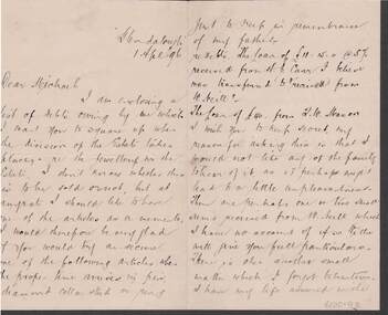
Letter to Michael from S. Carr, dated 1 Apr '96. S. Carr has enclosed a list of Debts he owes and he asks Michael to square up when the division of the Estate takes place. He doesn't know if the jewellery will be sold or not, but he would like a piece to keep in remembrance of his father. The loan from T. W. Mason he wished to keep secret because there might be a little bit of unpleasantness in the family. He also mentions one or two small sums from Mr. Neill which he has no account of. He also mentions he has a life assurance with the Australian Mutual Provident Society and where the policy is, and also if anything else crops up he will let him know. Signed S. Carr. On a separate piece of paper is a list of Loans from W. Neill, H. J. Carr and T. W. Mason.S. Carrbusiness, stockbroker, kelly & allsop, kelly and allsop collection - letter to michael, h j carr, w neill, t w mason, australian mutual provident society, s carr, 'glendalough' -
 Bendigo Historical Society Inc.
Document - CONNELLY, TATCHELL, DUNLOP COLLECTION: PERPETUAL EXECUTORS' & TRUSTEES ASSOCIATION OF AUSTRALIA
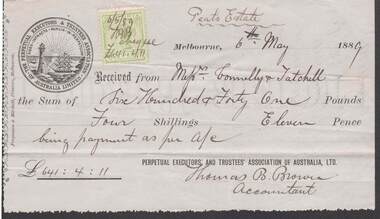
Receipt Perpetual Executors' & Trustees Association of Australasia, for 641/4/11, being payment for Peat's Estate. Dated 6th. May 1889.Green one penny stamp at the topt of the document Company emblem on the top leftbusiness, legal, peat's estate -
 Bendigo Historical Society Inc.
Book - COHN BROTHERS COLLECTION: BOOK OF DIVIDEND LIST
Cohns Bros book of dividend lists commencing 55th, 1915 - 79th, 1930. Inside front page attached receipt No L8728 re Asher Salaman trust dated 7th December 1916. Also attached receipt dated 13th January 1925 re estate of Catherine Hayes. Names and addresses of shareholders listed over 1915-1930 period. Attached payment slip name of M Cohn, Union Bank of Australia Limited dated 18th June 1925. Attached payment slip name Mrs Harriet E Richmond dated 18th June 1925. Attached payment slip name Mrs E M W Watson. Attached payment slip, J P & H L Hyland dated Dec 1924. Payment slip attached name E M Wilmott Watson Dec 6th 1924. Payment slip attached name C P W Dyring dated 21 / 6 1924. Payment slip attached name Jp & H L P Hyland dated 21st June 1824. Payment slip attached name I F hyland dated June 23 1923. Attached pencilled handwritten absenttees named Watson, Browne. Attached handwritten note pertaing to distribution of monies to E M Watson & Browne. Attached handwritten note pertaining to E M W Watson L W Browne L M Landishut. Two attached payment slips Dated 6th June 1916, June 17th 1916 name E Watson.bendigo, industry, cohn bros brewery, cohns bros dividend lists no 55 1915- 79th 1930. cohns shareholder names and addresses listed 1915-1930 -
 Bendigo Historical Society Inc.
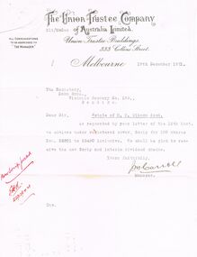
Document - COHN BROTHERS COLLECTION: TYPED LETTER DATED 1921
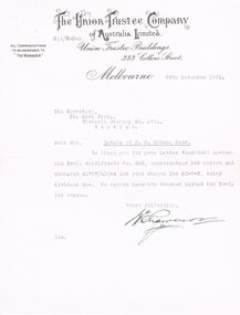
Typed correspondence on printed letterhead of The Union Trustee Company of Australia limited at Union Trustees Buildings 333 Collins Street Melbourne dated 29th December 1921 to the Secretary Cohn Bros brewery re shares in estate of M C Gibson deceased. Signed ? Manager.bendigo, industry, cohn bros brewery, the union trustee company. m c gibson. cohns bros brewery shares -
 Bendigo Historical Society Inc.
Document - COHN BROTHERS COLLECTION: TYPED LETTER DATED 1921
Typed correspondence on printed letterhead of The Union Trustee Company of Australia Limited Melbourne dated 19th December 1921 to Cohn Bros Brewery re shares in estate of M C Gibson deceased. Signed J M Carroll.bendigo, industry, cohn bros brewery, the union trustee company of australia limited. m c gibson j m carroll -
 National Vietnam Veterans Museum (NVVM)
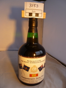
Memorabilia, Port Bottle
Unopened green bottle commemorating presentation of new colours to the battalion of 8 RAR and 9 RAR8th/9th Battalion Royal Australian Regiment Commemorative Tawny Port bottled on the occasion of the presentation of new colours to 8RAR and 9RAR 31st October 19898 rar, 9 rar, commemorative port -
 Port Melbourne Historical & Preservation Society
Poster - Map showing ancesttral family estates of Melbourne's first people pre European Settlement, Marcus Lee Design, This once as it was - the ancestral family estates of Melbourne's first people, 2016
This once as it was - the ancestral family estates of Melbourne's first people. Colour map with text. Pre European settlement. Based on Colonial survey maps of Port Phillip Bay region. 1837 and 1864australian aborigines, natural environment, arweet derrmut, point ormond, st kilda, yuro yuroke, bunjil, burrarung river, queensbridge falls -
Port Melbourne Historical & Preservation Society
Photograph - Four couples at champagne celebration, Tom Hills Archive, 1983
COPYRIGHT TOM HILLS ESTATE MUA Photograph of a group of 4 couples at champagne celebration, possibly 1983 as "Ünder the Hook" is on the table. Arcjie Alceri, Stan Clarke, Tom Hills, Mr Strong, two unidentified women, Mrs Strong and Till Beggs. Herald Sun copyrightsocieties clubs unions and other organisations, piers and wharves - waterside workers, transport - shipping, tom hills, waterside workers federation of australia, archie alceri, stan clarke, till beggs, mr strong, mrs strong -
Port Melbourne Historical & Preservation Society
Financial record - Commonwealth of Australia Treasury Bond, Commonwealth of Australia, May 1951
Belonged to Shirley Anderson, deceased Sept 01, whose estate was left to Wendy LowensteinCommonwealth of Australia Treasury Bond, 1951, interest coupons which have been partially spent to 15th Nov 1957. Printed on paper in coloured ink; (faceside) violet, reddish-orange and black graphics and type on off-white paper; (obverse side) light brownish graphics and text. The words "31/8% repayable 1st November, 1962-1965"appear as a heading.In pencil on faceside: '11/35' On back in stamped pink ink: '25 Jun 1951'commonwealth government -
 Royal Australian and New Zealand College of Obstetricians & Gynaecologists (RANZCOG)
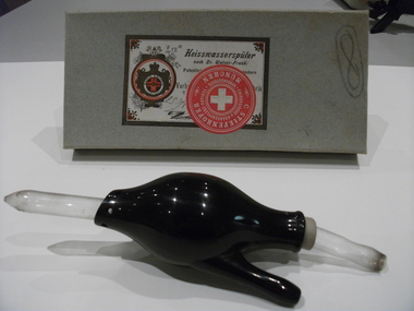
'Heisswasserpülar' vaginal douche associated with Dr Edward Rowden White
This douche, with the manufacturers object description of "heisswasserspulungen" which translates as healing water douche, came from the Edward Rowden White Estate. The heisswasserpular designed by Dr Walzer-Frank was used as a vaginal douche by attaching a rubber hose to the glass connector which was then inserted into the vagina. Acquired from Dr Harold Attwood, the Curator of the Medical History Unit, University of Melbourne, 2 April 1996. In a letter to Geoff Bishop ... " I think they are best held in your collection rather than here." (see accession file)Transferred from the collection of the Medical Unit (Brownless Medical Museum) University of Melbourne, from the Sir Edward Rowden White Estate. Sir Edward (1884-1958) was a Foundation Fellow of the Australian Regional Council of RCOG and was the first Chairman of the Arthur Wilson Foundation, and created (with his brother) the EA Rowden White and Edward R White Foundation for Medical Research at the Royal Women's Hospital in 1955. Black bakelite bulb with glass douche nozzle and irrigator connections at each end. Stored in original box. Handwritten in blue pencil on side of box: "Vaginal Douche".vaginal irrigation -
 Bendigo Historical Society Inc.
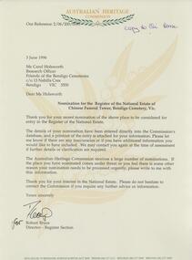
Document - FRIENDS OF WHITE HILLS CEMETERY COLLECTION: LETTER, 3 June 1996
Document. Letter to Carol Holsworth from Robert Bruce, Australian Heritage Commission RE nomination of Chinese Funeral Tower at Bendigo Cemetery for the register of the National Estate. Letter dated 3 June 1996. -
 Bendigo Historical Society Inc.
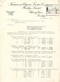
Document - HANRO COLLECTION: LETTER ESTATE CHARLES HANDSCHIN
Letter dated 1st March,1934 on Farmers and Citizens Trustees Company Bendigo Limited Charing Cross, Bendigo. the letter is addressed to the Secretary Hanro (Australia) Knitting Mills Pty. Ltd. Bendigo re Estate Charles Handschin P/A Alice Handschin. The letter list shares certificates in the names of Charles and Alice Handschin that have been enclosed in the letter and request the company to take the necessary steps the facilitate transfer to Hanro Consortium. The letter is signed by R. A. Rankin Manager.hanro, clothing, share register -
 Bendigo Historical Society Inc.
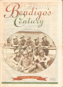
Newspaper - LONG GULLY HISTORY GROUP COLLECTION: BENDIGO'S CENTURY VOLUME FIVE: 1940 - 1949
Newspaper supplement titled Bendigo's Century Volume Five: 1940 - 1949. Each year has heading of Who's Who, Weather, Sport and Business. Front page is titled Bendigo's Century and has a photo of a group of soldiers in uniform and with rifles. They were district servicemen on leave in 1944. Each year has heading of Who's Who, Weather, Sport and Business. First years are 1940 - 1949 titled Bendigo as it was. It has two photos of women wading through the 1949 Pall Mall flood waters and one of Miners in the crib room of the Central Deborah Mine. They are Jackie Lewis, Bob Johnson, W Landy, Ryga Yates and Les Johnson. 1940 - Army moves in to racecourse, 1941 - Devastating fire at pottery, 1942 - Forces expand, 1943 - Nation's eyes on Bendigo, 1944 - News dawns of D-day landing, 1945 - City cheers the end of the war, 1946 - Celebrations begin in city, 1947 - Gallery gets top paintings, 1948 - Water plan looks good and 1949 - Flood takes a toll on city.bendigo, history, long gully history group, the long gully history group - bendigo's century - volume five: 1940 - 1949, bendigo advertiser, central deborah mine, jackie lewis, bob johnson, w landy, ryga yates, les johnson, central nell gwynne, department of defence, bendigo jockey club, 8th division, robert menzies, deborah mine, bendigo decentralisation vigilance committee, cr w h taylor, bendigo war funds organisation, the easter fair society, bendigo agricultural show committee, mr e g ham, mr j v fairbairn, cr a staples, the bendigo chamber of commerce, richard hartley smith abbott, captain harley abbott, bendigo art gallery, bill woodfull, bendigo high school, north deborah mine, boardwalk, toni riley pharmacy, windermere hotel, cr g a pethard, coliban system, north deborah mine, bendigo pottery, bendigo trades hall council, private lawrence burstall, major-general g j rankin mhr, andrew dunstan, ordnance factory, royal australian navy, hmas bendigo, sec offices, muioof, ymca, georger addlem, fred addlem, cr a j anderson, pauline buvhan thompson, leslie thompson, edward joseph leonski, bendigo football league, mr j dedman, william stephens, forest street methodist church, pte charles phillips, pte w e durward, pte t foley, william john stephens, central nell gwynne, air chief marshall sir arthur tedder, cr taylor, united nations, flying officer, r bruce tuff, flight lieutenant owens, royal air force, commonwealth war workers housing trust scheme, mr s mckinnon, bendigo decentralised vigilance committee, ravenswood estate, john lienhop mlc, margaret (peggy) brennan, strathfieldsaye shire council, school of mines, bendigo base hospital, william george ashman, ashman's tailors, bendigo jockey club, victorian football association, bendigo east swimming pool, deborah anticline, specimen hill methodist church, north deborah, adolf hitler, benito mussolini, australian 7th division, cr galvin, bendigo war funds organisation, hmas bendigo, lt-commander jackson, bendigo football league, central deborah mine, victoria day, cr truscott, bendigo gaol, lansellstowe, awas barracks, bendigo citizens committee, john cain snr, ordnance factory, bendigo agricultural society, the duke of gloucester, duchess of gloucester, bendigo tennis association, north deborah, gillies famous pies, aids & appliance shop, mrs georgina scott, dr j a neptune scott, alfred sisley, corot, daubigney, louis sonnenberg, gas employees' union, john lienhop, soldier settlement commission, burnewang estate, king george vi, princess elizabeth, lt philip mountbatten, mr e j w herbert, ansett airways, reg ansett, most rev, dr john mccarthy, dr bernard stewart, michael giudice, bendigo united breweries, bendigo lyric photo plays, bendigo sun newspaper, shamrock hotel, west bendigo progress association, alan mcdonald, south bendigo football club, albert collier, j t webbo, mervyn tresize, state rivers and water supply commission, eppalock reservoir, public works committee, bendigo rotary club, john edgar, bendigo base hospital, albert dunstan, benevolent home, magetti's wine hall, wallace reef wine hall, magetti family, albert magetti, lance galvin, bradford cotton spinnings (victoria) pty otd, arthur syer, stanley crossman, albert arthur dunstan, rev dr henry backhaus, city family hotel, lyric theatre, bank of australasia, city club hotelcolonial mutual building, r matchett & co, lansellstowe, leonard lansell, bendigo bas hospital, australian women's army service, mr hollway, kenworth (aust) ltd, foggitt jones's bacon factory, gordon sayers, sandhurst trustees, dr john drowley, alexander hislop, royal mint, north deborah mine, ironbark south mining company, central nell gwynne company, new chum syncline -
 Bendigo Historical Society Inc.
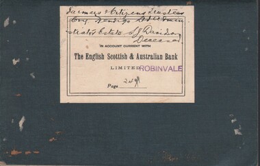
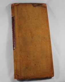
Document - MCCOLL, RANKIN AND STANISTREET COLLECTION: ESTATE - S. J. DAVIDSON DECEASED, 1928
Book: paper bag contains bank passbook - The English Scottish & Australian Bank Limited Robinvale.MCCOLL RANKIN & STANISTREETorganization, business, banking - legal, mccoll rankin & stanistreet -
 NMIT (Northern Melbourne Institute of TAFE)
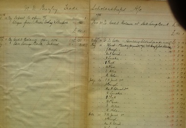
Account Book - CTS, Trade Scholarship Account 1915-1960, 1915-1960
Beazley Trade Scholarships. William Beazley was born in London in 1854 and arrived in Australia with his parents in 1855. Apprenticed as a saddlemaker he eventually became an estate agent and later local parliamentarian for Collingwood. Beazley lived all his life in Collingwood and following his death in 1912 part of his estate was bequeathed to Collingwood Technical School.Accounts from the early days of this trade scholarship. Includes names of early recipients.Black covered ledger book with dark red spine. Pasted inside cover is a printed explanation of the "W. D. Beazley Trade Scholarships for evening classes"Handwritten accounts throughout. No markings on cover.collingwood technical school, cts, accounts, w d beazley, beazley trade scholarships, account books, nmit, -
 Deaf Children Australia
Book, Endowment Book 1873 - 1920
Created by the Victorian Deaf & Dumb Institution, this is a record of the estates, bequests, bonds and insurance policies of the VD&DI from 1873 to 1920This is a record of how the VD&DI obtained funds from various sources.Brown leather bound book with red leather on spine under name with marbelled facing pages on front and back covers. Pages are laid out in ledger format and detail estates, bequests, bonds and insurance policies of the V.D.&D.I.Spine: "ENDOWMENT BOOK" in gold stampingdeaf children australia, deaf education, endowment book -
 Deaf Children Australia
Folder, Investigation Committee reports regarding future and policy for St Kilda rd policy, 1970-1973, started in 1970?
Sitting on a prime piece of real estate, over time there have been discussions on the best use of the site. Whilst there is no longer any suggestion of selling the site, it's ongoing development is still being discussed. Serious consideration was given to selling the St. Kilda Rd property to developers and changing sites. No indication is given for the rejection of this proposal, possibly in Board minutes of the time. This provides an insight into the pressures in the 1970s to sell the current site. A black foolscrap folder containing typed minutes of meetings of the Investigation Committee which was set up to investigate proposals which had been suggested regarding a future land policy. The meetings were held between 1970 and 1973. On front label: "MINITUES -/INVESTIGATION COMMITTEE/P.I.P." handwritten deaf children australia, dca, victorian school for deaf children, vsdc, st. kilda rd, the bluestone building -
Moorabbin Air Museum
Document (item) - John Porter Estate Collection, John Porter Estate Collection See Description for contents
-
Moorabbin Air Museum
Document (item) - John Porter Estate Collection, John Porter Estate Collection See Description for contents
-
 National Vietnam Veterans Museum (NVVM)
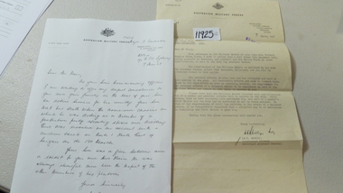
Document, Condolence Letter
Hand written Condolence Letter written to the family of Pte Douglas Brian Plain by his Commanding Officer Major N. Audeston on the 7th March 1968 on Australina Military forces letterhead. Type written letter by W.F. Sorsby, Lieutenant Colonel Adjutant General advising of Military Estate of Pte D.B. Plain and return of personal effects30cm x 21cmpte plain, condolence letter, australian military forces -
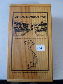
 National Vietnam Veterans Museum (NVVM)
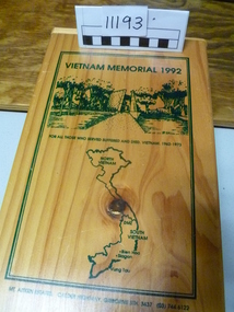
Memorabilia, Wine Box
Wooden wine box, lined with green felt and containing wine bottle and glass. Front features engravied map of Vietnam and outine of a memorial 1992.Vietnam Memorial 1992 (front). Inside of lid is info on National Memorial to the Australian Vietnam Forceswine box, vietnam memorial -
Moorabbin Air Museum
Document (item) - John Porter Collection
-
 National Vietnam Veterans Museum (NVVM)
Memorabilia, Vietnam memorial 1992
Commemorative wooden box containing a bottle of alcohol and inscribed liquor glass. Lid of box inscribed with map of Vietnam and jungle scenes. Inside of lid inscribed with description of national memorial to the Australian Vietnam Forces. Inside are two metal plaques inscribed "lest we forget" and "Vietnam 1962-1973"As abovememorial wooden box, vietnam memorial 1992 -
Clunes Museum
Financial record - BANK RECORDS, 1916-1979
The first Government controlled savings bank was established on 1 January 1842 under New South Wales legislation. Known as the Savings Bank of Port Phillip it was administered by a Board of Trustees and a Vice-President. Branches of this Bank were subsequently established in other parts of the colony. In 1853 a statutory body known as The Commissioners of Savings Banks in the Colony of Victoria was constituted under the Savings' Bank Act and each bank was thereafter to be a separate and independent institution with its own trustees and officers - however, between 1896 and 1912 the independent Savings Banks of Victoria merged to become a single institution and this development was formalised by the 1912 legislation. From 1980 the Bank was known as the State Bank of Victoria under the provisions of the State Bank Act 1980. The State Bank of Victoria established its own Archives before the Bank was sold in 1990 to the Commonwealth Bank of Australia. After the sale, the Archives of the State Bank continued to operate until the Archives' holdings were transferred to the state archives.Bundles of papers from the State Savings Bank, Clunes - Loss of Pass Book Notices 1918-1961 - Deceased Estates 1916-1965 - A/C Stops 1923-1961 - Passbook Cheque Book 1949 - Stat Dec 1946 - Dep. Book School Bank 1978-1979 - Pass Books (2) 1953-1968 and 1948-54state savings bank of victoria, bank documents -
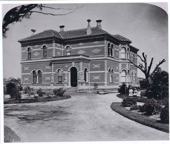 St Kilda Historical Society
Photograph, Donald McDonald, Rippon Lea, 1872
Two story polychorm mansion, victorian rennaisance, arched nische blacony and arched entryway, windows framed by arches, without double bay front rooms, garden setting with gravel drive and three little girls in formal dress. Built in 1868 for Sir Frederick Sargood, polychromatic romanesque style, architect Joseph Reed and Barnes, Photograph taken 1872. Ripponn Lea estate now in the National Trust of Australiablack and white photograph, unmounted, copy, good conditionRipponlea Photo 1872 -
Tatura Irrigation & Wartime Camps Museum
Army Uniform Accessories, 1939-45
Pieces from the uniform and personal effects of W. Culkin (Army WW2)15 Items from Estate of William Culkin, relating to his war service (WW2). Personal effects displayed in a clear topped box.|1x photo (sepia) of W. Culkin|Stripes|Colours (felt)|Colours (metal)|1x rising sun hat badge|1x prayer book (R.C.)|2x metal "Australia"s for shoulder straps|2x ID tags|1x summary of conditions of awards|1x description of ribbon awarded|2x compliments from Minister of State for the ArmyVarioustatura, ww2, uniform, uniforms, army -
Tatura Irrigation & Wartime Camps Museum
Book, Emergence of Bioregionalism in the MD Basin, 1993
An exploratory essay on he ongoing history of Murray Darling Basin includes legacies, explorations, soil erosion, irrigation divsity, land degradation, change, regionalism, conservation, maps of Vic. NSW and QueenslandGloosy cover, brown marbled scenes from Berri Irrigation Area Reiver Murray, South Australia on back. Maps, water scenes, Pyap Estates on front.murray darling basin, legacies, erosion, degradation, diversity, tatura, murray river, books, rural, industry -
 Robin Boyd Foundation
Slide, Robin Boyd, 1969
Robin Boyd travelled to the USA and Britain for several weeks. He attended the opening of the new Australian Chancery in Washington DC, where he had designed an innovative exhibition with cylindrical display cases and sound recordings.Colour slide in a mount. Thamesmead Estate, London, EnglandMade in Australia / 8 / JUL 69M2slide, robin boyd -
 Robin Boyd Foundation
Document - Manuscript, Robin Boyd, The Rape of Nareeb, 1965
Discusses the Estate of Nareeb, Kooyong Rd; 1888. The National Trust is disinterested, land denuded and house demolished, and there is needless destruction of natural and historic relics for redevelopment, particular destruction of trees exclusive to Australia. Boyd says it shows no consideration for future residents; innocence and undemanding passivity of consumers.Original manuscript of an article published as 'The Rape of Nareeb' in The Australian in 06.03.1965.Typewritten, quarto, 6 pagesnareeb, kooyong rd; national trust; destruction of natural historical environment; redevelopment, robin boyd, manuscript -
 Victorian Aboriginal Corporation for Languages
Book, Australian Heritage Commission, Conserving the national estate : a bibliography of national estate studies, 1991
... of national estate studies Book Australian Heritage Commission ...Since 1973 more than 3500 Aboriginal, historic and natural conservation projects have been funded. Many of these projects have led to both published and unpublished reports. This bibliography provides access to this information.national estate grants program, cultural heritage management, conservation