Showing 268 items
matching building relocation
-
 Lakes Entrance Historical Society
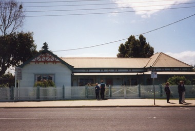
Photograph - Skippers Restaurant, 1999c
This building was the original home of the family of George Carpenter, son of John Carpenter, first contractor for construction of the man-made entrance to the lake system, the house was relocated to Hunters Lane, December 2002.Colour photograph of Skippers Restaurant, Esplanade. The photograph shows a weatherboard building, corrugated iron roof, gabled extension at left end, hipped extension at right. Historical evidence shows that the building consists of additions to original smaller residence. Lakes Entrance Victoriaarchitecture, township, restaurant -
 Sunbury Family History and Heritage Society Inc.
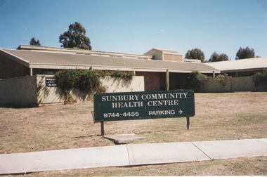
Photograph, Elwyn Davis, Former Sunbury Community Health Centre, March 2002
The first Sunbury Community Health Centre was built on the corner of Horne Street and Gap Road in a temporary building. As result of further funding in 1974, a permanent building was erected and opened in 1981 and operated from that site until 2000 when it was relocated into a larger and more modern building on the former Sunbury Primary School site in Macedon Street to accommodate Sunbury's expanding population and needs.It now operates under the name of Sunbury and Cobaw Community Health Centre. The old building was demolished and replaced with a fast-food outlet.A non-digital coloured photograph of the Sunbury Community Health Centre showing the notice board displayed in the front giving phone details and parking area.sunbury community health centre, health centres, gap road, horne street -
 Sunbury Family History and Heritage Society Inc.
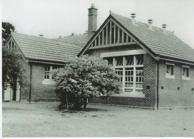
Photograph, c1910 - 1920s
The photo is of the Sunbury State School No. 1002, which replaced an earlier building. The Federation style red-brick school was built in 1911 and was officially opened on 2nd May 1912. An extra room was added in 1945 to accommodate increased enrolment. In 1999 the school closed at the Stawell Street site and the students relocated to the former and refurbished bluestone Industrial School in Jacksons Hill. The former red-brick school building is now part of the Sunbury Community Health Centre complex.Many former and present-day residents in Sunbury have attended this school over the years.A black and white photograph of a small school building. It is a federation style building with brick walls and a tiled roof.sunbury state school no. 1002. -
 Bendigo Military Museum
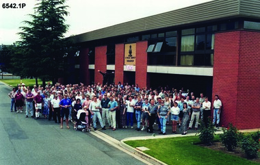
Photograph - 4 Fd Svy Sqn Closure Ceremony 25 Nov 1995, 4 Fd Svy Sqn, Keswick Barracks, Adelaide, 25.11.1995
Between 1915 and 1951, military topographical mapping in SA was conducted by Royal Australian Survey Corps (RASvy) units based outside the state. In February 1952, Army HQ Field Survey Section (Central Command Detachment) was established in Adelaide in a drill hall at Largs Bay. It was tasked with providing map coverage in the Woomera and Southern areas of the state. The section was subsequently reorganised as Central Command Field Survey Section moving firstly to Hampstead Barracks, Hampstead in 1953 and then into accommodation at Keswick Barracks in 1954. In 1957 the Section commenced mapping operations in the NT. The Unit was relocated to the old cavalry stables in 1961 and was redesignated Central Command Survey Unit and remained there till 1973. In 1970 the Unit was redesignated 4 Fd Svy Sqn and engaged in operations conducted in PNG from 1972 to 1974 inclusive. In 1973 the Squadron moved into a brand new two-storey specially designed and purpose built building adjacent to the old building. The old building then became the Squadron Q and Map store with an interconnecting lobby to the new building. Since 1975 the Unit was involved in the 1:50,000 Mapping Programme in WA, NT, QLD, SA and conducted many other operations within Australia and overseas. Post disbandment of the Corps the old Squadron building (cavalry stables) now houses the Army Museum of South Australia (AMOSA). The Royal Australian Survey Corps was amalgimated into the Royal Australian Engineer Corps in July 1996. In the lead up to this amalgamation, 4 Field Survey Squadron Keswick Barracks, Adelaide, South Australia was disbanded in 1995. A closing Ceremony was held on 25 November 1995 at 4 Fd Svy Sqn Keswick Barracks attended by about 208 former members of the Unit. A photo was taken of attendees at that event on the day and a list was prepared of attendees. All attendees were sent a copy of the photograph and the list of names as a momento of the Unit and the ceremony..1P A4 Print of an original photo of attendees at the 4 Fd Survey Sqn Closure Ceremony at Keswick Barracks 25 Nov 1995. .2P A4 Print of the names of the attendees at the 4 Fd Survey Sqn Closure Ceremony at Keswick Barracks 25 Nov 1995. Approx 208 attendees.royal australian survey corps, rasvy, fortuna, army survey regiment, army svy regt, asr, 4 fd svy sqn -
 Eltham District Historical Society Inc
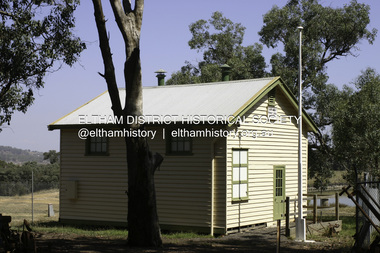
Photograph - Digital Photograph, Alan King, Yarrambat Heritage Museum, 23 January 2008
Original Yarrambat Primary School building at the Yarrambat Heritage Museum, Yarrambat Park. At the museum, visitors can gain an insight into Yarrambat’s past since non-Aboriginal settlement. The museum includes the original Yarrambat Primary School, which was moved to the site in 2000 and now serves as the Yarrambat Historical Society headquarters.The museum also includes a fully operational battery (gold-bearing ore crusher) driven by a McDonald 30HP diesel engine built in Richmond in 1938. The battery was relocated from the Golden King Mine in North Oatlands Road, Yarrambat, where it operated until 1984.1 Other exhibits include farming implements and machinery from the Yarrambat district. Published: Nillumbik Now and Then / Marguerite Marshall 2008; photographs Alan King with Marguerite Marshall.; p25This collection of almost 130 photos about places and people within the Shire of Nillumbik, an urban and rural municipality in Melbourne's north, contributes to an understanding of the history of the Shire. Published in 2008 immediately prior to the Black Saturday bushfires of February 7, 2009, it documents sites that were impacted, and in some cases destroyed by the fires. It includes photographs taken especially for the publication, creating a unique time capsule representing the Shire in the early 21st century. It remains the most recent comprehenesive publication devoted to the Shire's history connecting local residents to the past. nillumbik now and then (marshall-king) collection, yarrambat heritage museum, yarrambat historical society, yarrambat primary school -
 Lakes Entrance Historical Society
Photograph - Historic House, Holding M, 2004
Building was originally part of Mrs Carstairs Boarding House at New Works. Relocated to rear of Carstairs Heyfield House. Occupied by Orme Crawford, garage proprietor, motor mechanic in 1930's. Tommy Kent, garage proprietor, 1950's to 1960's. (Local knowledge)|Also nine photographs various views of the transportation of the house to Ostlers road Lakes Entrance.Colour photograph of a residence in Marine Parade, prior removal from site by Plymin Transport to a location on corner of Colquhoun and Ostlers Roads. Lakes Entrance Victoriahouses, local history -
 Falls Creek Historical Society
Photograph - Axtrack oversnow vehicle Falls Creek Hotel
This vehicle, an Axtrack is located outside the Falls Creek Museum. It was built by Axel Andre who worked in Falls Creek as a mechanic for several years in the early 1970s. Axel was an engineer by trade. He built this small twin track vehicle for Ivan Spargo at the Falls Creek Hotel and then progressed to building bigger and better models. This included one for Ziggy Doer at Koki and Neville Mashford at Snowland purchased two of them. Some of these machines were also exported to America. Axel Andre later established a company Axtrack Engineering in Melbourne. There are still three of these Axtrack vehicles on the hill at Falls Creek in 2024. The vehicles were used for commercial purposes such as transporting supplies and staff around the mountain. The Spargo family from the Falls Creek Hotel used this vehicle for oversnow transport and it advertised Harvey Wallbanger Happy Hour. Ivan and Joy Spargo relocated from Melbourne to Falls Creek in 1965. They purchased a piece of leasehold land and built Spargo Lodge. This was a dorm style chalet built to accommodate large groups and families. Their son Rob Spargo met his future wife Blanche in 1967 when she was on holiday in Falls Creek. They married and purchased the site where the Falls Creek Hotel is today. The steep gradient of the site was a challenge to build on but was the best location available in the village. In 1970 Rob’s sister Leonie and her husband Glenn joined the business, and they started operating the hotel in 1972. The family played a critical role in the growth of the Falls Creek community and were involved in the foundation of Falls Creek Primary School and Falls Creek Search & Rescue. Rob was also involved in the start-up of Ski Victoria and has served as a member of the Chamber and Resort Management Board. Rob’s eldest daughter Lisa competed with the Australian Ski Team from 1985 to 1989 and has worked as a ski instructor in Australia, Austria & Colorado. In 2010 Lisa and her husband Damien Allport joined the family business and her parents retired to Tawonga South in 2014. Their children are now the fourth generation of the Spargo family living at Falls Creek enjoying the alpine lifestyle and providing outstanding hospitality. The 40 year tradition of the Harvey Wallbanger Happy Hour held on Tuesdays and Thursdays continues at Falls Creek Hotel in 2024.This item is significant because it depicts an important form of transport at Falls Creek, VictoriaA coloured photo of a black Axtrack oversnow vehicle decorated with red and yellow advertising.FALLS CREEK HOTEL APRES ENTERTAINMENT HARVEY HOUR TUES & THURS 3.30 PM LIVE ENTERTAINMENTaxtrack, oversnow vehicles, falls creek transport, spargo lodge, falls creek hotel -
 Eltham District Historical Society Inc
Photograph - Digital Photograph, Alan King, Nillumbik Shire Offices, Greensborough, 30 March 2008
Nillumbik Shire Council transferred to the former Diamond Valley Shire Offices in Greensborough after municipal restructuing. The offices became the official Nillumbik Shire Council Offices on 16 October 1995. The former Shire of Diamond Valley Civic Centre or Shire Office building was officially opened on 26th February 1972. Archtiects were A.K. Lines, McFarlane & Marshall and it was built by L.U. Simon Pty Ltd, The Diamond Valley Shire had been created in 1964 from part of the City of Heidelberg. On December 15, 1994 the Shire of Nillumbik was established. Under the Council amalgamations imposed by the Kennett government, the Shire of Eltham, Shire of Diamond Valley and City of Heidelberg ceased to exist with the establishment of Nillumbik Shire Council and the City of Banyule.The new Nillumbik shire surrended the west riding from Eltham to Banyule but in place gained parts of the former Diamond Valley Shire which itself had been created in 1964 from parts of the City of Heidelberg. Three unelected and non-local Commissioners were put in place by the government bringing democracy into question by many members of the local community. The Commissioners determined to abandon the former Shire of Eltham offices located in Main Road, Eltham and in turn occupy the former Shire of Diamond Valley offices located at the boundary of the new shire with Banyule, in Civic Drive, Greensborough. In July 1996 the Commissioners sold the former Eltham Shire Offices and had them bulldozed leading to many years of communiity protest over the process and future development applications. The site has remained vacant ever since. Published: Nillumbik Now and Then / Marguerite Marshall 2008; photographs Alan King with Marguerite Marshall.; p43 It was the need for roads that led to this district’s first council. In 1853 a committee was formed to improve the rough roads, some in Kangaroo Ground being almost impassable in winter.1 The committee fundraised by voluntary levies and grants to improve in particular, the main road between Kangaroo Ground and the Plenty River. From this committee arose the Eltham District Road Board, in 1856, which was the precursor to the Eltham Shire Council. The Board’s first chairman was Kangaroo Ground farmer, John Barr. Secretary was the former committee’s secretary, Andrew Ross, Kangaroo Ground’s first school teacher, and founder of the district newspaper, The Evelyn Observer.2 Most of the board’s income came from a toll-house north of the Lower Plenty Bridge, which funded such projects as a road from Kangaroo Ground to the Caledonia Diggings. In 1871 the Shire of Eltham was proclaimed, with its boundaries the same as those of the Road Board, and Councillor A Donaldson of Kangaroo Ground was the first president. Eltham was at the southern tip of the shire, which extended north to Kinglake and east beyond Yarra Glen. In 1878, part of Kinglake was added to the shire, while the area east of Watts River, near Healesville was removed. In 1912, then again in 1958, the shire was further reduced. Yarra Glen, Steels Creek, Tarrawarra, parts of Healesville and Christmas Hills, were transferred to the Shire of Healesville. In 1972 a smaller area, at Kinglake, was transferred to the Shire of Yea, leaving 277 square kilometres in the Eltham Shire. Perhaps no other Victorian municipality has had so many meeting places. Although from 1858 to 1904, the council convened at the office in the home of Secretary Charles Wingrove, the board, and later the council, also met at other more central locations.3 The board moved from the Fountain of Friendship Hotel to the Eltham Courthouse, to the Kangaroo Ground schoolhouse. It then met at the Kangaroo Ground Hotel, which some considered put it in danger of interruptions by people ‘the worse for liquor’.4 In 1885 the council met at the hall on Mr J Donaldson’s land at Kangaroo Ground. After Wingrove’s retirement, the council rented space at the Kangaroo Ground General Store and Post Office. Then, in 1917, the council bought the former office of The Evelyn Observer, after its printing works transferred to Hurstbridge. In 1934, fire destroyed the shire office, which was temporarily relocated to the Kangaroo Ground home of Shire Secretary, Mr P J McMahon. In 1941, the shire office moved to a new building (which included a public hall) in Eltham, at the corner of Arthur Street and Main Road, where the Eltham Village Shopping Centre was eventually built. Growth required new offices, which opened in 1965, on the former Shillinglaw property in Main Road.5 In 1994, as part of municipal restructuring under the Jeff Kennett Liberal Government, most of the Eltham Shire formed part of the new Shire of Nillumbik. It joined with the north section of the Diamond Valley Shire and parts of the Healesville and Whittlesea municipalities. The Diamond Valley Shire had been created in 1964, from part of the City of Heidelberg. Turbulence followed Nillumbik Shire’s formation. Under the Commissioners the council transferred to the former Diamond Valley Shire offices in Greensborough, and the Eltham council offices were demolished. In March 1997 the first five-member Nillumbik Council was elected. But, in October 1998, the government suspended the council and appointed an administrator . Early in 1999, shire residents voted to increase councillors to nine: comprising five ward councillors and four shire-wide councillors. Elections were held in March 1999. Then, before the March 2002 elections, nine new wards were created.6 In 2008 these were reduced to seven. Today [2008] the council governs a varied population of more than 60,000 people living in townships and on bush properties in the green wedge.This collection of almost 130 photos about places and people within the Shire of Nillumbik, an urban and rural municipality in Melbourne's north, contributes to an understanding of the history of the Shire. Published in 2008 immediately prior to the Black Saturday bushfires of February 7, 2009, it documents sites that were impacted, and in some cases destroyed by the fires. It includes photographs taken especially for the publication, creating a unique time capsule representing the Shire in the early 21st century. It remains the most recent comprehenesive publication devoted to the Shire's history connecting local residents to the past. nillumbik now and then (marshall-king) collection, greensborough, nillumbik shire council offices, civic drive -
 Eltham District Historical Society Inc
Photograph - Digital Photograph, Marguerite Marshall, Eltham Library, Panther Place, Eltham, 18 April 2008
Rear view of Eltham Library showing loading dock and ramp to the front of the building. Designed by multi-award winning architect, Gregory Burgess, for which he won the 1995 Royal Australian Insitute of architects (Vic.) Merit Award in the New Institutional category. Covered under Heritage Overlay, Nillumbik Planning Scheme. Published: Nillumbik Now and Then / Marguerite Marshall 2008; photographs Alan King with Marguerite Marshall.; p183 Award-winning Eltham Library, with its earthy tones blending into the nearby parklands, celebrates some of the best of Eltham’s spirit. Designed by multi-award winning architect, Gregory Burgess, the library at Panther Place, won him the 1995 Royal Australian Institute of Architects (Vic) Merit Award in the New Institutional category.1 The design is typical of Burgess’ work, emphasising natural materials and forms, and the integration of building and site.2 In its distinctive architectural character, Burgess celebrated the spirit of Eltham’s artist/architect Justus Jörgenson and mud-brick builder Alistair Knox. However this library, which opened in 1994, follows decades of efforts to acquire a suitable library for local residents. It was only in 1971 that Eltham acquired its first purpose-built library. In the 1930s books were borrowed from a mobile library run by Mr Foster of Bible Street. From the 1930s to the early 1950s, adults borrowed books from the newsagency and general store in Main Road (still a newsagency) near Arthur Street. As late as the 1950s, adults borrowed books in the shire office foyer, then in Main Road near the corner of Arthur Street.3 In the early 1950s the ratepayers voted for lower rates rather than a library, in a referendum to build a public library financed by higher rates. Children depended on volunteers for their library service until 1966. In 1946 the inaugural meeting of the Eltham War Memorial Trust’s Women’s Auxiliary, decided to support the Trust by raising funds to buy land and build a Children’s Library, Baby Health Centre and other facilities. The auxiliary formed the Children’s Library Committee, which included Mrs Morrison, Mrs Bow and Mrs Currie. They ran a library service in the stage area of the Eltham Hall, at the corner of Arthur Street and Main Road. In 1952 the books were relocated to a room in the newly opened Baby Health Centre on Main Road. Then in 1961, the Children’s Library received its own hall beside the Eltham Pre-School Centre on Main Road. From there, each month, volunteers delivered books to every school in the shire. In 1966 the Children’s Library closed after 17 years of service, following the transfer of the Trust land and buildings to the Shire of Eltham. The books were donated to nine schools in the shire and to Community Aid Abroad. An important boost to the library service came in 1965, when the Heidelberg Regional Library Service was formed by the City of Heidelberg with the Shires of Eltham and Diamond Valley. Its first library service for Eltham Shire was a bookmobile van. Books for children and adults were finally housed in one building in 1966, when the shire converted the Brinkkotter house in Dudley Street, into a library. At last in 1971, the Eltham Library moved to new premises attached to the shire offices near Panther Place. However these were demolished in 1996, by State Government appointed commissioners during council amalgamations. Meanwhile the Heidelberg Regional Library Service was disbanded in 1985 and the Yarra Plenty Regional Library Service was established. The burgeoning population brought pressure for a bigger library. Eltham was one of several municipalities in the 1970s and 1980s, battling with the State Government for adequate funding for public libraries. Funds were so tight, that in 1987 Eltham councillors threatened to close the library. However public petitions persuaded them to set aside funds to replace the cramped library facilities. In 1992 the Federal Government gave $887,496 towards the $3 million cost of the 1560 square metre library.4 The result is a light and spacious building with surrounding verandas, made of sustainable natural materials including earth and recycled and radially sawn timbers. It includes a gallery and function areas. In 2004 Mr Burgess won Australian architecture’s highest accolade: the Royal Australian Institute of Architects Gold Medal. He has received more than forty professional and community awards.This collection of almost 130 photos about places and people within the Shire of Nillumbik, an urban and rural municipality in Melbourne's north, contributes to an understanding of the history of the Shire. Published in 2008 immediately prior to the Black Saturday bushfires of February 7, 2009, it documents sites that were impacted, and in some cases destroyed by the fires. It includes photographs taken especially for the publication, creating a unique time capsule representing the Shire in the early 21st century. It remains the most recent comprehenesive publication devoted to the Shire's history connecting local residents to the past. nillumbik now and then (marshall-king) collection, eltham, eltham library, panther place -
 Eltham District Historical Society Inc
Photograph - Digital Photograph, Alan King, Eltham Court House, 730 Main Road, Eltham, 28 December 2007
The Eltham Court House is Eltham's oldest public building. It was classified by the National Trust in 1977. In 1857 five Eltham residents petitioned the licensing magistrates of the Heidelberg district asking for better police protection, including from itinerant gold prospectors who turned to crime when their quest was unsuccessful. In response the Eltham Courthouse was constructed in 1860. Over the years it has also been used for other activities, including for electoral polling purposes, inquests, early meetings of the Eltham Roads Board and even as an overflow classroom. This type of localised solution is characteristic of the self-reliance preserved in Eltham today. The court house is an important symbol of the spirit which makes Eltham distinctive as a community. The Eltham Courthouse is historically significant because its construction was intended to emphasise the centralised control over law and order in the Colony of Victoria in the wake of the 1852 Snodgrass committee report on the Victorian police force and the resulting Police Regulation Act (1853). The nature of the Court House planning and use of architectural devices make the building's function easily interpreted. The arrangement of rooms, with public entry and clerical rooms to the rear, and the use of raised floor levels throughout these spaces to signify relative rank is easily perceived. The distinction in entries, public, magistrate and person-in-custody, and the existing court furniture enhances appreciation of this building. The Eltham Court House is one of only two intact examples in the state of this simple design with projecting entry. The building is of architectural significance because it retains intact early features. These include use of handmade bricks, simple decoration, roof trusses, timber ceiling boards, original windows, doors and associated hardware and a collection of court furniture. Additions to the court house have been done in a manner which did not interfere with the fabric of the original building. Typical cases heard before the Court of Petty Sessions included financial debt, straying livestock, theft, assault, drunkenness, public disorder, truancy, motor vehicle offences, unregistered animals and failing to have children attend school, or be vaccinated. The courthouse operated for over 120 years before it closed in 1985. In April 2021, Nillumbik Shire Council authorised restoration of the building and furnishings. The extensive works required for the total restoration of this highly valued heritage building was undertaken by Ducon Building Solutions and other specialist contractors. Covered under Heritage Overlay, Nillumbik Planning Scheme. Victorian Heritage National Trust of Australia (Victoria) State significance Published: Nillumbik Now and Then / Marguerite Marshall 2008; photographs Alan King with Marguerite Marshall.; p65 A demand for better police protection resulted in the building of the Eltham Courthouse and the police residence beside it. In 1857 five Eltham residents petitioned the Heidelberg district licensing magistrates. They pointed out that Eltham had two hotels, a population of about 1000, and many strangers employed on the public roads. Yet the nearest police were at Heidelberg eight miles (12.8km) away, or at the Caledonia Diggings 21 miles (33.7km) away.1 Subsequently the courthouse and then the police residence, near the corner of Main Road and Brougham Street, were built in 1859/60. The courthouse is Eltham’s oldest public building and the National Trust classified it in 1977. It ceased operation in 1984 and has since been used by local groups. There are only six other known examples of similar small brick country courthouses in Victoria . For £536, a Mr Duncan built the courthouse – a neat, narrow, oblong building with handmade orange bricks. Its gabled roof and porch are covered with brown slate tiles and it has 12-paned windows. Inside, the roof is peaked and the courthouse is still ventilated by oblong slits near the ceiling. Most of the fine carved timber and upholstered furniture is original. The original prisoners’ door, now permanently closed, led from the police station to the dock. Builders, Langridge Wright and Witney built a timber police station (since demolished) and a brick residence to its north,2 for £1150/7/-. Built around the same time were the lock-up behind the residence, also later demolished, and the two-storey orange brick stables. The former police residence also has a brown slate roof and handmade bricks. The front veranda roof is made of corrugated iron, as is the roof of the back weatherboard extension. The application for police protection was approved within a few months and police operated from a cottage rented at ten shillings a week and owned by William Jarrold. This was probably the one at the corner of Main Road and Dalton Street called Jarrold or White Cloud Cottage. In 1858 a second constable was appointed to Eltham following a fight at the hotel. The timber police office a replica of which was built in the early 1990s is at the building’s side. The lock-up was demolished following the relocation of the police to a new station in about 1952. The residence has been used as the Eltham District Historical Society centre since 1997. Records show court cases were held at Eltham before the courthouse was built, but the location is unknown. Some court cases were not very different from those today. In 1891 a man was charged with being drunk while in charge of a horse and was fined ten shillings. The courthouse was used for other purposes during its long history. It was probably used as a polling place as indicated by old photographs of election-day crowds outside. The Eltham Road Board met there from the early 1860s until 1868 when the Board transferred to Kangaroo Ground. During the same period the Road Board Secretary used the courthouse as an office until 1867 when it was transferred to his home at Wingrove Cottage. The courthouse was also used as an overflow classroom for the Dalton Street school in 1875. The two buildings can further link us with Eltham’s early days through Police Department correspondence. The first constable-in-charge was George Reid. In 1860 a letter to The Argus newspaper signed ‘A Sufferer’ declared the Eltham police were not active enough in their duties. The writer suggested that the ‘very snug’ police quarters were too comfortable, and he detailed various incidents including one of an alleged break-in to the Road Board Secretary’s home. But the Board Secretary, C S Wingrove, wrote to the Police Department refuting The Argus letter saying he had received full co-operation from Sen. Constable Peter Lawler.This collection of almost 130 photos about places and people within the Shire of Nillumbik, an urban and rural municipality in Melbourne's north, contributes to an understanding of the history of the Shire. Published in 2008 immediately prior to the Black Saturday bushfires of February 7, 2009, it documents sites that were impacted, and in some cases destroyed by the fires. It includes photographs taken especially for the publication, creating a unique time capsule representing the Shire in the early 21st century. It remains the most recent comprehenesive publication devoted to the Shire's history connecting local residents to the past. nillumbik now and then (marshall-king) collection, eltham, eltham court house, main road -
 Eltham District Historical Society Inc
Photograph - Digital Photograph, Alan King, St Andrews Anglican Church, St Andrews, 30 January 2008
Built c.1868, St Andrew’s Anglican Church is Nillumbik Shire’s oldest timber church and is historically, socially, and spiritually significant to the Shire of Nillumbik. The church is historically significant because it may have given its name 'St Andrews' to the town (another suggestion is that the name came from the local hotel), it is also historically significant as one of only four buildings that remain from the Caledonian goldfields era of Queenstown (now St Andrews) and one of only a handful of buildings that survived the 1960s bushfires. The church is historically, socially, and spiritually significant because it has played an important part in community life for more than 150 years; a proposal to move the church in 1984 met with strenuous opposition. Much of the fires on Black Saturday 2009 were the north of the town. The town itself remained intact - as did this heritage building. Covered under Heritage Overlay, Nillumbik Planning Scheme. National Trust of Australia (Victoria) Local significance Published: Nillumbik Now and Then / Marguerite Marshall 2008; photographs Alan King with Marguerite Marshall.; p69 The St Andrews Anglican Church and former St Andrews Primary School, are two reminders of the district’s early days, when it was founded on gold. St Andrews, then called Queenstown, was the earliest goldfield in the Caledonia Diggings.1 It was the Upper Diamond Gold Mining and Administrative Centre, with 3000 miners. Queenstown was also the seat of the Court of Petty Sessions. The church and school then stood close to European and Chinese stores, three hotels, a brewery and a quartz mill.2 In 1861, Queenstown was officially proclaimed a township. From 1865, the name Queenstown was interchangeable with St Andrews, until 1952, when the town was officially named St Andrews. As gold declined from the early 1880s, Queenstown changed dramatically into a settlement of small farms. St Andrew’s Anglican Church, built in 1868, is the Shire’s oldest timber church and possibly gave its name to the township.3 The small timber church was opened on November 1, 1869, by the Dean of Melbourne. Anniversary tea meetings helped raise funds, and in 1889, a three-bedroom parsonage was built alongside. In 1910, the vicar, the Rev Selwyn Chase (and friend of the Scouting Movement’s founder, Baden Powell), established the 1st Queenstown Scout Troop, only two years after Scouting began in Australia. The church was important to the lives of many local residents who were baptised, married and had funeral services there. But by the 1950s the population had decreased and so did the weekly attendances. Around the mid-1960s the church closed, then fell into disrepair. So in the mid 1980s it was sold to the Education Department and was under threat of relocation or demolition. However this caused such opposition from locals,4 that instead, the Anglican church leased it as part of the Panton Hill parish5 and it was reconsecrated in 1987. Queenstown’s first school was held in a tent after transferring from Andersons Creek, Warrandyte.6 From 1858 a church school, Caledonia Diggings, stood west of the main road, a quarter of a mile (0.4km) before Buttermans Track. In 1882 the school was moved from a leased building, owned by headmaster Robert Harris, into a larger building on the corner of the School and the Heidelberg-Kinglake Roads. It had been moved from Smiths Gully and included a teacher’s three-roomed residence.7 In 1887 the school was replaced by the Queenstown State School No 128, although it was also called Caledonia Diggings until 1891. In 1956 it was renamed St Andrews. Still standing, this building is now used as the St Andrews Community Centre and the residence is leased for private use. The original timber-lined room remains alongside the extensions, and is distinctive with its high ceiling and tall small-paned windows. In 1984 a new school was built 500 metres west of the old school. Many residents have contributed much to St Andrews but one family that has done so for several generations is the Harris family. Robert Harris was an active member of the St Andrew’s Anglican Church, and worked hard at improving the town’s amenities until his death in 1887. He was a signatory to the successful 1863 petition to the Chief Commissioner of Police, against the proposed removal of the Court of Petty Sessions and police station at the Caledonia Diggings. The police station stayed in the town until 1917. Harris was Head Teacher of Queenstown State School from 1864 to 1874, then of the Smiths Gully school until it closed in 1882, and he continued teaching at Panton Hill until his death. His son, Robert Charles Harris, was editor and printer of the local newspaper, The Evelyn Observer, from 1873 until 1915. Robert’s son, William Shelley Harris, served in the Boer War and in World War One. In 1928 he became Kinglake National Park’s first park ranger. Robert’s daughter Elizabeth, taught needlework at Queenstown State School, and later ran the post office in Kinglake.This collection of almost 130 photos about places and people within the Shire of Nillumbik, an urban and rural municipality in Melbourne's north, contributes to an understanding of the history of the Shire. Published in 2008 immediately prior to the Black Saturday bushfires of February 7, 2009, it documents sites that were impacted, and in some cases destroyed by the fires. It includes photographs taken especially for the publication, creating a unique time capsule representing the Shire in the early 21st century. It remains the most recent comprehenesive publication devoted to the Shire's history connecting local residents to the past. nillumbik now and then (marshall-king) collection, st andrews, st andrews anglican church -
 Eltham District Historical Society Inc
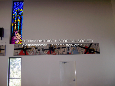
Photograph - Digital Photograph, Marguerite Marshall, Stations of the Cross, Clifton Pugh (1961); Our Lady Help of Christian's Church, Henry Street, Eltham, 11 October 2006
... of the Heidelberg Church Parish. In 1912 the church was relocated to a new... of the Heidelberg Church Parish. In 1912 the church was relocated to a new ...Stations of the Cross by Clifton Pugh is a contempooray art piece in four sections making up 11 stations of the cross. It was commissioned by the Catholic parish in Eltham (Our Lady Help of Christians) in 1961 Published: Nillumbik Now and Then / Marguerite Marshall 2008; photographs Alan King with Marguerite Marshall.; p81 Art is an important means of nurturing faith at Our Lady Help of Christians Church, Henry Street, Eltham. The Stations of the Cross by Clifton Pugh and The Crucifix with the Ascending Jesus by sculptor Charles Rocco are two of the fine works that enhance the parishioners’ worship. These two inspiring works of art were added in 2001 – long after Roman Catholics began worshipping in Eltham around 1864. This beautiful worship centre was built following hardship and change – for parishioners have endured their church being destroyed by fire and have built four churches since they first worshipped together. Before 1864, according to local legend, a visiting priest administered sacraments in the parlour of former convict-turned-respected citizen Thomas Sweeney at Sweeneys Lane, Eltham.1 The first church was blessed in September, 1865, by the Archbishop of Melbourne, Dr Goold. It stood on an acre (0.4ha) of land in Little Eltham as that area was known then, near the present Fordhams and Main Roads and was part of the Heidelberg Church Parish. In 1912 the church was relocated to a new building on the present primary school site at 1 Henry Street. This was closer to the town centre, which had moved from Little Eltham after the railway line was extended to Eltham in 1902.2 In 1958 the church split from the Sacred Heart parish, Diamond Creek, to become a parish in its own right, with Father Tom Curran as inaugural priest. Not long after in 1961, a fire destroyed the church and huge working bees under the prominent Catholic builders, the Sibbel brothers, rebuilt and extended it, using the original altar from the first church. It was then that builder and parishioner Herman Sibbel asked his friend, artist Clifton Pugh, to paint the Stations of the Cross for the church. But the priest, Father Curran, neither approved of Pugh’s bohemian reputation nor liked the paintings, so they were hung in the corridor of Our Lady’s Primary School instead. The parishioners almost sold the paintings in 1989 to pay for major school renovations. However the paintings remained there for about 40 years, until 2001, when the church was extensively renovated by Father Barry Caldwell. Another change awaited the church, as it outgrew its building, later to be used as the school hall. So, in 1976, the present church was built across the road. Three beautiful stained-glass windows depicting the Passion, Death, Resurrection and the presence of Christ’s Spirit, link these with the church’s experiences. The first depicts a bushfire in Eltham, referring to their church damaged by fire. Another represents the Resurrection of Christ with new growth on a blackened stump and the Holy Spirit is represented by the Southern Cross. A window depicting Our Lady Help of Christians by parishioner Bill Peperkamp, was donated by parishioners to commemorate the Silver Jubilee of Father Desmond G Jenkins’ ordination to the priesthood on July 27, 1977. This, with the statue of Mary, creates a Marian shrine. In the 14 Stations of the Cross painted on four masonite panels Pugh captures the pathos of the suffering Christ and his disciples.3 The figures are stylised, except intriguingly, that of Pontias Pilate, who looks like Clifton Pugh. Charles Rocco’s sculpture is an extraordinary Jesus figure being raised from the Cross. The delicate stainless steel mesh of the figure creates a sense of the power of God over death. The organ, built in 1868 by George Fincham and Sons, was first installed in the All Saints’ Anglican Church, East St Kilda, then in the St Andrews Church, Clifton Hill. It was rebuilt into a modern instrument with a donation from parishioner Jim Murray, in memory of his wife Gwendolene Mary.4 Church members created their own work of art in front of the entrance, by painting designs and messages on 700 tiles. This work indicates the strong church family and faith expressed in art, that awaits the worshipper inside.This collection of almost 130 photos about places and people within the Shire of Nillumbik, an urban and rural municipality in Melbourne's north, contributes to an understanding of the history of the Shire. Published in 2008 immediately prior to the Black Saturday bushfires of February 7, 2009, it documents sites that were impacted, and in some cases destroyed by the fires. It includes photographs taken especially for the publication, creating a unique time capsule representing the Shire in the early 21st century. It remains the most recent comprehenesive publication devoted to the Shire's history connecting local residents to the past. nillumbik now and then (marshall-king) collection, art, clifton pugh, stations of the cross, our lady help of christans, installation -
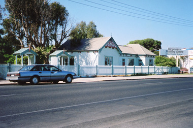 Lakes Entrance Historical Society
Photograph - Historic House, Fish, Marie, 2002c
This building was the home of the Carpenter family for about 80 years, converted to a restaurant known as 'Skippers', relocated as a private residence in 2003, whole lot demolished to make way for the Lakes Entertainment Centre.|This is the before paired photograph used in the 150 year Lakes Entrance 1858-2008 display.|The after paired photograph number is 01447.1|Also one 12 x 16 framed photograph used in room display.Colour photograph of a weatherboard building on Esplanade. The building has an iron roof, picket fence at front. Carpenters Holiday Centre sign to east of building. Motor vehicle parked on street. Lakes Entrance VictoriaCarpenters Holiday Centre houses, room display, local history -
 Sunbury Family History and Heritage Society Inc.
Photograph, Sunbury Gun
The Sunbury Gun was originally donated to the Shire of Bulla by the Clarke family. For many years it stood at the intersection of Barkly, Stawell and Macedon Streets. Over the years it became very dilapidated and as traffic along Macedon Street gradually increased it was decided to refresh and relocate it to a triangular site opposite the Memorial Hall in 1970. In March 1982, the weathered Sunbury Gun was restored and housed in an atmospherically controlled glass case and displayed again in the triangular site opposite the Memorial Hall along with the War Memorial and the Starkie fountain.A non-digital black and white photograph of a gun in a large building.sunbury gun, memorial hall, clarke family, stawell street, barkly street -
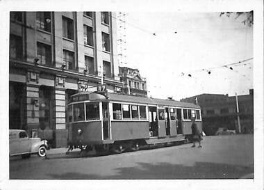
 Melbourne Tram Museum
Newspaper, Flemington Kensington News, "1900s Racecourse Rd lives on", Original photo c1906
Newspaper clipping from the Summer issue of Flemington Kensington News titled "1900s Racecourse Rd lives on", featuring a photo of a NMETL enclosed tramcar east bound in Racecourse Road at the intersection with Wellington St Flemington showing the centre poles and buildings in the street. In the background is the railway overbridge. On the corner is a Tailor and Hatter shop. Item written by Melissa Montang, mainly about the Bendigo Community Bank relocating from Racecourse Road. Source of the photograph - Images of Yesteryear.trams, tramways, racecourse rd, nmetl, flemington -
 Melbourne Tram Museum
Document - Research Notes, H. S. McComb, "Extracts from the Minutes of the Prahran and Malvern Tramways Trust which was constituted under Act of Parliament No. 21030 in 1907", 1940's
Original and carbon copy of "Extracts from the Minutes of the Prahran and Malvern Tramways Trust which was constituted under Act of Parliament No. 21030 in 1907", 10 foolscap sheets. Includes depot purchase, regrading of High St, extension to Burke Road, relocation of water mains, surveys, starting of construction, tenders for track and buildings, opening, extension, F. A. McCarty & Co., Dandenong Road lines, railway bridges, extension of High St to St Kilda Road, MMBW, finances. Items 2041 to 2052 within box 72.3 in a brown folder marked "PMTT" in red pencil.trams, tramways, pmtt, malvern, routes, track, surveys, malvern rd, tenders, construction, opening, dandenong rd, mmbw, finances -
 Melbourne Tram Museum
Photograph - Set of 2 Black & White Photograph/s, Lee A Ratten, late 1930s
Set of two black and white photographs of tramcar 815 in Collins St at Spencer St. Tram 815 was one of 24 W5 class trams built by MMTB at Preston Workshops in 1937. Entered service Saturday 13 November 1937. In April 1984 converted to SW5. Currently stored at Newport Workshops. Was relocated to the site of the former Glenhuntly Post Office in Glenhuntly Road Feb. 2020. Photo shows tram at corner with Specer St station parcels building and VR building in background. Also shows building on corner which was used by State Saving Bank of Victoria. Destination shown as "Kew Depot" route number 47.trams, tramways, w5 class, collins st, spencer st, route 47, tram 815 -
 Clunes Museum
Photograph
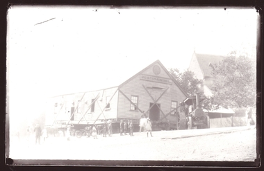
Although the inscription of .1 states this building was transported to Maryborough it's clear that the building remained in Clunes at least until the knitting mill was relocated from Fraser Street, (now known as Collins Place) to the corner of Bailey and Camp Streets, perhaps this building was extraneous its new location and was then moved to Maryborough at some date after 1918..1 SEPIA PHOTOGRAPH OF THE MOVE OF THE SALVATION ARMY HALL TO COLLINS PLACE WITH A CROWD OF PEOPLE IN FRONT OF THE BUILDING AND A LARGE "TRACTOR" IN THE DOORWAY .2 SEPIA PHOTOGRAPH OF THE MOVE OF THE SALVATION ARMY HALL TO COLLINS PLACE WITH SEVERAL PEOPLE IN FRONT OF THE BUILDING AND A TRACTOR MOVING INTO POSITION .1 on reverse; At Clunes part of mill ready for transport to Maryborough (Plate is similar not negative of this)local history, churches - salvation army, salvation army hall -
 Old Gippstown
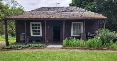
Building - Slab Kitchen
A slab construction cottage built in Ripplebrook in 1880 as a home for a single female landowner by the name of Ada Donaldson, and later relocated to Labertouche. It was donated to Old Gippstown by the Mason-Brook Pastoral Co. of Labertouche. A small building of horizontal timber slabs. It has a verandah over the front entrance and the front porch, a main living area with a cast iron stove in the fireplace and a separate room (probably a bedroom). There is a stone chimney on the back wall and the roof is shingled. Originally a cottage in its own right, the slab kitchen is now a part of the Bushy Park display.Medium local historic significance.A small building of horizontal timber slabs. It has a verandah over the front entrance and the front porch. There is a stone chimney on the back wall and the roof is shingled. This building was built in 1880sout kitchen, old gippstown, west gippsland, gippsland, gippsland heritage park, goldfields, coal mine, victorian era, moe, historical village, timber slab cottage, ripplebrook, labertouche, mason-brook pastoral co., baw baw shire, latrobe valley, old gippsland heritage park, gunaikurnai, latrobe city council -
 Lakes Entrance Historical Society
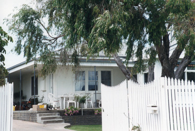
Photograph - Historic House, 2000
Building was lounge and ballroom for Robin Hood Inn, a popular guest house situated on corner of Esplanade and Carstairs Avenue. It was broken up, and components relocated, to make way for Sherwood Lodge Motel in 1958.Colour photograph of a fibro dwelling, hipped roof with gable extension, veranda over main room with triple sash window and French door. White timber picket fence and gate, situated at 8 North Arm Avenue, Lakes Entrance Victoriahouses, heritage study -
 Bendigo Military Museum
Document - SURVEYORS RESTORATION REPORT BENDIGO, Bendigo City Council, c.1986
Surveyors report 1986 regarding the restoration of the Bendigo Cenotaph continued on from Cat No 8255. The document starts with a report to a Council meeting held on August 18th 1986. This is a more detailed report of the first by Dr. A.H. Spry (AMDEL) followed by Mr W. Barton City Engineers Department. The state of the Cenotaph was also compounded by it's situation re the Bendigo Creek. Main points where. The Cenotaph is sited on the Bridge over the Creek not alongside it as was supposed. The Cenotaph concrete foundation was resting on the old timber decking which is in an advanced state of decay among 5 main points. Report goes on with points. Conclusion; "It would of course be necessary to demolish the Cenotaph to carry out this work". Estimate of costs in brief. 1. Bridge repairs $72,000.00. 2. Cenotaph repairs. - Demolish & rebuild $110,000.00. Options - There are only two options (as per estimate) or demolish and relocate to another location under 3 sections (a) (b) (c). Recommendations; Motions referred to Estimates 1986/87 and RSL for comments - 1 carried, 1 lost.Document, paper 3 pages foolscap size, all print in black, copy of original, stapled with the pages is a Bendigo City Compliments Card in blue text.Main points, "Building Surveyors report - 8th September 1986 - B.18/86 - restoration of Cenotaph (32.7.1)"document, surveyor, cenotaph, brsl, smirsl -
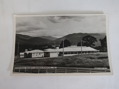 Kiewa Valley Historical Society
Photo - Tawonga District General Hospital
The hospital was transported from Bonegilla (ex-army hospital ward) and began operations in 1949. It was located at the corner of Ryder's Lane and the Kiewa Valley Highway opposite the Bogong pub. In 1961, the hospital was relocated to the centre of the Mt Beauty town in the former SEC Administration buildingThe Tawonga District General Hospital was created in the late 1940s as the local population grew as a result of the SECV constructing the KHES and the town of Mt Beauty. Prior to this, the nearest hospital was at Yackandandah and medical care was provided by medical practitioners in Mt Beauty.B & W postcard photo showing Tawonga District General Hospital in front of mountains and below a cloudy sky.Printed in white at the bottom left side "Tawonga District General Hospital" and on back "Postcard / A Genuine Photograph"tawonga hospital, medical care, mt beauty hospital., tawonga district general hospital -
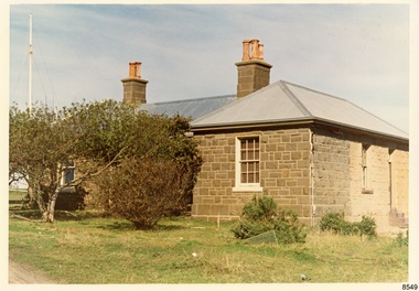 Flagstaff Hill Maritime Museum and Village
Photograph - Historical, Flagstaff Hill, The Lighthouse Keeper’s Cottage showing re-roofing carried out by Council, 1970s
The coloured photograph shows the Lighthouse Keepers' Quarters at Flagstaff Hill, Warrnambool. The building was erected in the 1850s on Middle Island, Lady Bay. It was relocated to its current location in the late 1870s along with the two lighthouses, the chart room and the privy. The Warrnambool City Council replaced the iron roof on the cottage in the 1970s and further work has since been carried out. The picture shows the poor condition of the stonework on the right hand side of the cottage. After the cottage ceased to be used by lighthouse keepers, it was rented out by various organisations and later became disused. The Historical Society requested the re-connection of power. The right hand side of the cottage was repurposed for use by Flagstaff Hill Maritime Museum and Village. in the 2020s it was restored and fitted out as the Alexander Farncombe room, which is used for temporary exhibitions. This photograph, a print, is one of a set of five that show the site of Flagstaff Hill. It is presumed to have been taken by John Lindsay, Founding Director of Flagstaff Hill Maritime Museum and Village. One of the photographs in the set has the pencil inscription "Photo J Lindsay". It was taken in the early 1970s during the initial stages of the development of Flagstaff Hill as a Museum and Maritime Village. The photographs belonged to the donor's grandparents, who lived in the Warrnambool district of Allansford/Naringal. The photograph is a record of the Lighthouse Keepers' Quarters at Flagstaff Hill Maritime Museum and Village before its development and opening in 1975. It shows the condition of the building at the time and some of the recent re-roofing. The photograph is significant for recording the condition of the original heritage listed building at that point in time.Coloured photograph, glassy print, one of a set of five. Photograph shows the Lighthouse Keepers' Quarters, focused on the Assistant's Quarters on the right. It shows the a new iron roof that had been installed by the Warrnambool City Council, and the condition of the bluestone,walls. There are clay chimney pots on the two chimneys. A set of steps are at the entry on the right hand side. The flagstaff is on the left of the photograph. The photograph's paper has the printer's watermark on the back. The early 1970s picture is presumed to have been photographed by John Lindsay, Warrnambool.Label on the back: "THE BLUESTONE COTTAGE SHOWING RE-ROOFING CARRIED OUT BY COUNCIL. The Historical Society has requested Council to have S.E.C. power re-connected"flagstaff hill maritime museum and village, warrnambool, maritime museum, shipwreck coast, 1970s, photograph, lady bay, flagstaff hill site, john lindsay, cannon emplacement, middle island, flagstaff, lighthouse keepers' quarters, lighthouse keepers' residence, alexander farncombe, re-roofing, s.e.c. connection -
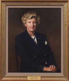 Vision Australia
Painting - Artwork, Portrait of Diana Jones, 1992
Framed portrait of Diana J. Jones who the first female president of the Association for the Blind since Tilly Aston. It is part of a series of paintings commissioned by the AFB Board to commemorate the work of past presidents of the organisation. Mrs Jones sits facing the painter with both hands clasped in her lap. She is wearing a black double breasted blazer, white shirt, blue beaded necklace and earrings and a gold bracelet . A white kerchief sits in her breast pocket. Diana Jones served for 8 years on the General Committee before being elected President. During this time she was deputy chairman of the Reach Out Appeal to raise funds for the building program and President of the Honorary Services Group which co-ordinated volunteers and gave them a spokesperson on the General Committee. In her 8 years as President a great deal was accomplished. New centres were opened or extended throughout Victoria and the Metropolitan area, volunteer services expanded and the Vision Resource Centre at Kooyong was built into which 3RPH radio was relocated. A Vision Information hotline, audiology services and the National Centre for Ageing and Sensory Loss were established, the Braille and Talking Book libraries was incorporated into the Association and the Charlie Bradley Cricket Pavilion opened at Kooyong. In 1990 Diana Jones became a member of the first Board of Directors of the newly incorporated Association for the Blind Ltd which ushered in a new era, requiring strict observance of financial and accounting methods in order to ensure continued Government funding. Mrs Jones was highly regarded by clients, volunteers and staff as a capable hard-working leader. Her services to the Association and over many years to the wider community, were recognised in her appointment as a Member of the Order of Australia in the 1993 Queen's Birthday Honours. She passed away in July 2009.1 art original in gold frame The plaque at the base of the painting reads 'Dame Diana J. Jones, AM DSJ / President 1984- 1992 / Association for the Blind'. association for the blind, diana jones -
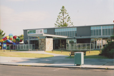 Lakes Entrance Historical Society
Photograph - Sports and Community Club Lakes Entrance Victoria, 2006
Lakes Sports and Community Club on Esplanade shows single story building with modern facade, child playground beside lawns in foreground Lakes Entrance Victoria. Built on site of Carpenters Camp Park residence which was relocated to Hunters Lane in 2003Colour photograph of Lakes Sports and Community Club on Esplanade shows single story building with modern facade, child playground beside lawns in foreground Lakes Entrance Victoriabusinesses, roads and streets -
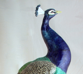 Flagstaff Hill Maritime Museum and Village
Decorative object - Peacock, Minton Majolica life-size model, Paul Comolera, artist, Designed: c. 1873; Made: c. 1875
This majestic peacock embodies the technical achievement, skill and ingenuity of artisans during the 19th century. It is now known as the 'Loch Ard Peacock' and was designed and modelled in 1873 by Paul Comolera (1818-1897) and fired in one piece at the Minton factory at Stoke-on-Trent in the United Kingdom in 1875. The peacock has been portrayed in symbolic motifs and has figured heavily in folktales and fables since antiquity, and many cultures around the world see it as a symbol of beauty, rebirth and power. Wealthy Victorians loved majolica, and the large peacock would have been the ultimate home accessory as a conservatory ornament – combining their desire for nature, the exotic and vibrant colours. The peacock model was listed in catalogues by Minton & Co. for a retail price of 35 guineas or sold as a pair for 90 guineas. Minton & Co. was founded in 1793 by Thomas Minton (1765–1836) and became a famous pottery and porcelain manufacturer. Comolera was a French artist and sculptor, renowned for dramatic naturalistic forms and life-size renditions of birds and animals that won him admiration in public and artistic circles. He was employed by Minton & Co. from 1873 to 1880, and the life-sized peacock became his best-known work. Comolera kept a live peacock loaned from the nearby Duke of Sutherland's Trentham Hall Estate in his studio to create a life-size model of fine buff earthenware model, which was then hand painted in brilliantly coloured green and blue glazes to mimic the peafowl’s dazzling plumage. There are no surviving production records, but according to documents in the Minton Archive, nine peacocks were made by Comolera. However, today, some historians now believe that twelve were fired at the Minton factory; research is ongoing. These peacocks were so admired that Minton & Co. used them as exhibition showpieces at International Exhibitions in London, Paris, and the United States of America, ensuring the company had a worldwide reputation. So, when Melbourne hosted an International Exposition in 1880, Minton & Co. sent out ceramics and tiles, and in particular, this peacock was intended to be part of their exhibit in the British Court in the Exhibition Building, built in the Carlton Gardens. The early dispatch date (1878) indicates that the company may have intended to exhibit their wares, including the peacock, at the 1879 Sydney International Exhibition, but the company did not take up this option. The ship that Minton & Co. used to bring the peacock and their other wares to the Australian colonies was the ill-fated Loch Ard, which sunk after striking Mutton Bird Island near Port Campbell, Victoria, in calm foggy weather in June 1878 on the final leg of the ship's journey to Melbourne. The loss of 52 lives made it one of Victoria’s worst shipwrecks. Therefore, this peacock never made it to the grand exposition in Melbourne, as Minton & Co. had planned. Charles McGillivray dragged this peacock, still in its original packing case, onto the beach in the gorge just two days after the Loch Ard went down. The peacock was rescued unscathed apart from a chip on its beak (only repaired in 1988). After a disagreement with a Melbourne Customs Officer, Joseph Daish, McGillivray stopped his salvage operations, leaving the peacock on the beach. The second salvagers were James Miller and Thomas Keys. Miller was a member of the firm Howarth, Miller and Matthews, Geelong, who had brought the salvage rights to the Loch Ard wreck on 10 June. When Miller and Keys arrived at the wreck site, a storm had washed many of the salvaged goods, including this peacoc,k back into the sea. The two men found the peacock in its case ‘bobbing along in the water’ and pulled it back to the beach. To ensure the peacock wasn't washed out to sea again, Miller and Keys hauled the packing case containing the peacock up the gorge's cliff face to the top, ready to be transported. In an interview in 1928, Keys claimed that at the time of the rescue, the head had broken from the body. This account was proven to be true in 1988, following the birds' display in Brisbane. This peacock began its life in Australia, not in the grandeur of an International Exhibition as intended, but in the hallway of a simple domestic house in Geelong. It appears Minton & Co. did not attempt to buy this peacock back. Florence Miller, daughter of James Miller (Loch Ard salvage rights holder), later remarked that the only item of real value rescued from the wreck had been the peacock and that this had been kept by her father in the family home at Malvern for many years and became a treasured family possession. As such, this 'Loch Ard peacock' was almost forgotten and mistaken with other Minton peacocks around the world. Miss Florence Miller tried to sell the peacock due to financial difficulties in the 1930s but was unsuccessful. While attempting to sell her Loch Ard relic, it was displayed in the window of the old Argus newspaper office, which was at 76 Collins Street, Melbourne; the Argus had relocated to the corner of Elizabeth and La Trobe Streets in 1926. Between 1935 and 1939, the old Argus building was occupied by the Joshua N. McClelland Print Room, which sold not only paintings and prints but also antiques and authentic replicas, as well as hosting exhibitions. Miss Florence Miller loaned her peacock for display at the Victorian Historical Exhibition held in the National Gallery on 1st June 1935, the 57th anniversary of the Loch Ard wreck. As a result, the peacock attracted public attention in books, newspapers and magazine articles that told the story of its survival from a shipwreck. Miss Florence Miller was keen to sell the peacock, even writing overseas to Captain Blain on November 30th, 1938, about the possibility of a sale, but this became no longer possible due to the outbreak of war. Recent information points to the Loch Ard peacock being owned by John S R Heath before its sale to Frank Ridley-Lee in May 1941. Research is ongoing, but it seems likely that John Samuel Robert Heath, a leading Melbourne dentist with a practice in Collins Street, and his wife, a dental mechanic, had purchased Miss Miller’s Loch Ard peacock before its sale in 1941. They were lovers of fine arts, music, wine and food. The peacock in the window of the old Argus building could have attracted their attention as they had already purchased the old stone Presbyterian Church on Warrigal Road, Oakleigh, in 1933 and had converted its interior. The home, renamed The Studio, even included Melbourne’s first all-electric kitchen. The peacock was perfect for display in the Studio’s entrance. A magazine article published after the conversion was completed included photographs of the interior. The picture of the ‘portico’ had a caption below that stated, “Some of her [Mrs Heath’s] finest pottery was salvaged from the Loch Ard Wreck”. In 2025, Heath’s two remaining sons remember running around in the entrance with the peacock standing there, oblivious to its value. Heath was an accomplished artist, studying under Max Meldrum. He painted and exhibited his works at The Studio and in a public exhibition, and he was a finalist eight times in the coveted Archibald Prize portrait competition, including the submission of his self-portrait that is now part of his grandson’s collection. The next owner of the Loch Ard Peacock was Frank Ridley-Lee. He displayed it at his home in Ivanhoe after buying it at an auction in May 1941. The peacock remained in the hands of the Ridley-Lee family until it was offered for sale by auction in 1975 as part of an art collection belonging to Mrs Ridley-Lee's estate. The peacock was not sold at this time, as the reserve price of $4500 was not met. This news was passed on to the board of the newly created Flagstaff Hill Maritime Village. Urgent efforts were made to collect the necessary money through fundraising by the Warrnambool City Council and public donations. The Fletcher Jones Company and the Victorian Government contributed half the cost. On 9 September 1975, the Loch Ard peacock was purchased by Flagstaff Hill Maritime Village, and it found a new home at the maritime museum. Since then, it has only left Warrnambool twice. Firstly, in 1980, at the centenary celebrations of the Royal Exhibition Building in Melbourne, and secondly, in 1988, the peacock was given pride of place at the entrance to the Victorian Pavilion at the Brisbane World Expo, acknowledging that this Minton Majolica peacock is the most significant shipwreck object in Australia. The Minton majolica peacock is considered of historical social and aesthetic significance to Victoria and is one of only a few 'objects' registered on the Victorian Heritage Register (H 2132), as it is a most notable and rare object associated with the Minton factory of the 1870s and works by the celebrated sculptor Paul Comolera along with the wreck of the Loch Ard on the Victorian coastline. This Minton peacock is historically significant for its rarity; it was one of only 9-12 known to exist. The shipwreck of the Loch Ard is also of significance for Victoria and is registered on the Victorian Heritage Register Ref (S 417). Flagstaff Hill has a varied collection of artefacts from Loch Ard and its collection is significant for being one of the largest accumulation of artefacts from this notable Victorian shipwreck. The collections object is to also give us a snapshot into history so we can interpret the story of this tragic event. The collection is also archaeologically significant as it represents aspects of Victoria's shipping history that allows us to interpret Victoria's early social and historical themes. The collection is historically significant is that it is associated, unfortunately with the worst and best-known shipwreck in Victoria's history. The peacock, resplendent in polychrome glaze, stands perched on a rocky plinth decorated with vines, leaves, flowers, blackberries and wild mushrooms. The peacock’s breast is cobalt blue; the wings and legs are in naturalistic colours. The tail is a mass of feathers coloured in green, ochre blue and brown — a fantastic display of artistry and Minton expertise. Inscribed at the base :P Comolera, and a Minton & Co. design number: 2045.flagstaff hill, warrnambool, maritime museum, shipwreck coast, loch ard, loch ard gorge, peacock, paul comolera, victorian heritage register, minton peacock, minton & co., stoke upon trent, bird figures, mintons, ceramics, international expositions, majolica, naturalistic, staffordshire, john samuel robert heath -
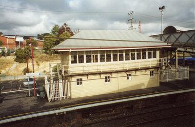 Ringwood and District Historical Society
Photograph, Ringwood Railway Precinct circa 2008, showing the heritage Signal Box, later relocated on the north side of the Station building
-
 Royal Australian and New Zealand College of Obstetricians & Gynaecologists (RANZCOG)
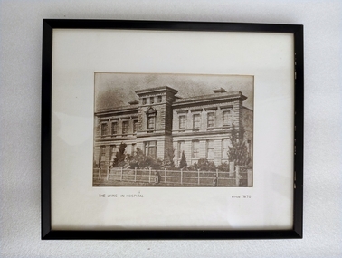
Photograph - Reproduction photograph, Charles Nettleton (1826-1902), The Lying In Hospital, circa 1870, c. 1868
This a cropped reproduction of a photograph taken by Charles Nettleton in c. 1868. Founded in 1856, the Lying-in Hospital was the second hospital to be established in Melbourne, after the Melbourne Hospital. It was, however, the first lying-in hospital in the Australasian colonies. The hospital was founded in a converted private house "Fairmont", which was located at 41 Albert Street, Eastern Hill (now East Melbourne). In 1858, the 'Lying-in Hospital' was relocated and opened in Madeline St, North Melbourne (now known as Swanston St, Carlton)." (The Women's) The building pictured here was eventually demolished in 1938 to make way for further extensions to the building. The original site in Albert Street was demolished in 1960, and the site is now occupied by the Melbourne Fire Brigade. A section of the wrought iron gates from the original site in Albert Street is held in RANZCOG's historical collection.Reproduction photograph of the front of a building. The building is three stories high. The lowest floor has eight large windows, with a door at centre, on the front side. One side window can also be seen at bottom right. There is a small flight of stairs leading up to the door. The second floor has eight windows in the same locations as the first floor, plus one additional window at centre instead of a door. The top floor is much smaller, with three small windows facing the front of the building. There are trees in the grounds in from of the building. House and grounds are enclosed behind a fence. There is a gate in the fence opposite the front door. Three figures are visible on the path outside the fence. One is at the centre of the image, and the other two are in the right hand corner. Text printed below image reads 'THE LYING - IN HOSPITAL circa 1870'. The image has been mounted and framed in a black wooden frame. An old display label for this image is attached to the back of the frame. handwritten text on backing board at back of work reads 'Probably prior to 1867 (J. Nattrass, 1968). Tape residue visible on backing board at upper right. A chain and two hooks have been added to the frame for hanging.