Showing 1995 items matching "cottage street"
-
 Ringwood and District Historical Society
Letter, Property for sale - Ringwood Shop and Dwelling Estate, Ringwood, Victoria - circa 1925
... on Block 81 in William Street ... £750 (K.) Cottage in Pitt Street... Street ... £750 (K.) Cottage in Pitt Street ... £650 (Total ...ID 5225 note: Further information relating to allotments marked on the hand-drawn plan are included in ID 5224 - Ringwood Station Estate.Typewritten letter from A.V. Greenwood with hand drawn plan of Ringwood Shop and Dwelling Estate, detailed description of property for sale, and top and side elevation views of house. (7 pages)(Transcript of first page - to unknown recipient) Phone 988 Central, 331 Canty Greenwood Pty. Ltd. 5 Flinders Street Melbourne. Dear Sir, 1. Attached please find drawings of my house at Ringwood. 2. It is for sale at £4,865 or to let at £5 per week to an approved tenant. 3. I sold it to Mr. De Garis and vacated it, but it is now back on my hands. 4. I leased another place instead of living in my own. I may be able to cancel same; in the meantime, however, I propose to sell or let my own. The painters are now going through the place; re-varnishing, re-oiling and re-polishing so that in about five days it will look "spick and span". 5. The house was specially built under my own supervision. 6. It is very suitable for a high class Guest House, Doctor's residence, Hospital or Convalescent Home. If you know of anyone whom it might suit, please communicate with them. DESCRIPTION 7. It stands on 305 feet of land facing Greenwood Avenue. It is cement, roughcast and hardwood, well oiled, and is now being redone so that the house is as good as new; red tile roof; verandahs three sides; two sleep-outs; five bedrooms; large dining room; very large music room with nooks, upstairs lounge, study; sewing room; built-in wardrobes and cupboards throughout; handsome kitchen with handsome pantry cupboard with drawers and glass front; one bath room; one shower room; wash house with patent copper and laundry. Every modern convenience, hot water system (through copper pipes with large copper cylinder) electric lights everywhere, outside and in, Yan Yean water laid on everwhere throughout house and gardens. Floors throughout are the very best, close set, stained and polished; dainty lead light windows etc. 8. There is a big garage, with tiled roof and two rooms with all conveniences for a married couple. Property is well drained with a system of its own. The house stands upon the top of a hill close to Railway Station, say 500 feet from the Footbridge. 9. The garden has expansive shrubs; sheds; fernery; tennis court. 10. A handsome piece of furniture goes with the house; a combination pantry and storeroom for groceries, milk, bread etc., consisting of drawers, glass and wire doors, as mentioned above. 11. It is within easy distance of Melbourne as it is only two minutes from Ringwood Station, which is a frequent electric train service bringing it within 39 minutes of the City. It is thought better by some to go further out into the country atmosphere and walk a short distance at the end than to go by train 20 minutes then walk 15 to 20 minutes. 12. The price quoted of £4,865 is made up as follows - 305 feet of land @ £5 ... £1,515 Garage and dwelling ... £300 House hot water system, American cupboard ... £2,600 Water, fencing, sheds & drain ... £250 For the lot ... £4,865 Should you require copies of the enclosed drawings I shall be pleased to supply same. 13. Mr. J.B. McAlpin is the local agent, Phone Ring. 7 (after hours Ring. 44) or you may phone me Central 988. 14. The house is south of the line, facing Greenwood Avenue and immediately at the back of Ringwood House, which is also my property. Yours sincerely, A.V. Greenwood (illegible) ..... (Transcript of second page) RINGWOOD SHOP AND DWELLING ESTATE See these letters on plan attached (H.) Ringwood House and Shops on 100 by 150 feet of land fronting Bedford Road 100 feet @ £10 per foot - £1,000 House and shops - £2,400 ... £3,400 Ringwood House consists of Boarding House, (Phone 101) and two shops, mainly brick; 9 inch walls. Will carry another story. Has music room, dining room, entrance halls, 10 bedrooms, large verandahs, all conveniences, hot and cold water, and stands on what will become a most valuable business corner. (F.)(G.) Mr. Greenwood's house, garage and sheds, stands on 307 feet of land fronting Greenwood Avenue. See detailed description attached ... £4,865 (J.) Cottage on Block 81 in William Street ... £750 (K.) Cottage in Pitt Street ... £650 (Total) £9,665 ..... (Description of third page - Subdivision Plan) Drawn by Edyth Greenwood, phone 988 Central. Subdivision includes Station Street, Pitt Street, Bedford Road, Wantirna Road, James Street, William Street (later Kendall Street), Greenwood Avenue, Ellison Street, and Haig Street. Circles denote blocks for sale. Squares denote house properties for sale. Other features marked include location of businesses along Main Street (Maroondah Highway), cool store, railway station, shop and police station on Bedford Road, church on Station Street, site of schoolmaster's residence and State School, and location of proposed public baths -
 The Beechworth Burke Museum
Audio - Oral History, Jennifer Williams, Nola (Nettie) Maher, 27 April 2000
Nola (Nettie) Maher was born in Beechworth on 31st December, 1935. Her father returned from World War One and purchased a miner’s cottage in 1919 where Nettie lived in for the majority of her life. Nettie worked for ten years at the Pittman’s Shoe Factory, once located on Ford Street, which was in operation from 1 July 1947 to 28 August 1961. She fondly recalls the camaraderie amongst the staff and certain managers, and details the factory processes, union activities and the work she continued to do once she was married and had children. This oral history recording was part of a project conducted by Jennifer Williams in the year 2000 to capture the everyday life and struggles in Beechworth during the twentieth century. This project involved recording seventy oral histories on cassette tapes of local Beechworth residents which were then published in a book titled: Listen to what they say: voices of twentieth century Beechworth. These cassette tapes were digitised in July 2021 with funds made available by the Friends of the Burke. Nola Nettie Maher’s account of her personal and working life in Beechworth and the local area during the 20th century is historically and socially significant to the cultural heritage of the region. She details important details about life and working in the region post World War Two, including insights into women’s working roles, as well as the social aspects of town life. This oral history account is socially and historically significant as it is part of a broader collection of interviews conducted by Jennifer Williams which were published in the book ‘Listen to what they say: voices of twentieth-century Beechworth.’ While the township of Beechworth is known for its history as a gold rush town, these accounts provide a unique insight into the day-to-day life of the town’s residents during the 20th century, many of which would have been lost had they not been preserved. This is a digital copy of a recording that was originally captured on a cassette tape. The cassette tape is black with a horizontal white strip and is currently stored in a clear flat plastic rectangular container. It holds up 40 minutes of recordings on each side.Nola Maher /beechworth, nola maher, nettie maher, listen to what they say, jennifer williams, oral history, hospital, private hospital, birth, miner’s cottage, kerosine, eucalyptus, rabbit, laundry, dressmaking, dressing certificate, dry cleaners, hotel, shoe, leather, shoe factory, uppers, pittman, ford street, charlie king, union, wages, new years eve, dance, memorial hall, married women, flexible hours, ice cream, milk bar -
 Orbost & District Historical Society
black and white photograph, late 19th century - early 20th century
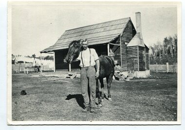
There are records of members of the Helmers family attending Bendoc State School. George Helmers was a prospector who mined all the gold from the dry gullies that ran into Bendoc. George was born in 1866, in Bombala, New South Wales, Australia. He was married to Euphemia Lock, born on October 19 1870, in Bendoc Upper, Victoria, Australia.This photograph is associated with early settlers of Bendoc, East Gippsland.A large black / white photograph of a man standing in front of a wooden cottage. there is a horse beside him, a woman standing on a verandah in the background and on the left is a clothes line with what seem to be nappies pegged out. There is also a copy of the original. on back - "George Helmers, Errinundra"helmers-george-bendoc -
 The Beechworth Burke Museum
Photograph - Carte de Visite
In July of 1880, Ann Jones' successful hotel in Glenrowan burnt to the ground during the Kelly siege. She had opened her business in the year prior having been unsuccessful in her attempt to run a tea-room business in Wangaratta. The first building on this particular site was the home Ann Jones had built for herself and her family. Two years later she converted the home and added the hotel to the rear of the structure. One year later it was burnt to the ground. This image depicts the streetscape of Glenrowan in 1883, three years after the siege. Importantly, it reveals the appearance of several buildings which can reveal information for how Glenrowan (as a small town) might have stood during the siege. These buildings are of typical Australian colonial "miner's cottage" style. On what would have been the site of Ann Jones' hotel, to the far left of the photograph, a police station stands. This police station was built before April 1883. This image was captured by an unknown photographer. This Carte-de-viste (CdV) previously belonged to the donor's grandfather, Daniel Mullins who was a Police Officer stationed at Glenrowan soon after the Kelly gang siege. Today, the siege has become an important part of Australian culture and Ned Kelly and the Kelly Gang (comprising of Ned Kelly, Dan Kelly, Steve Hart and Joe Byrne) has become ingrained in Australian history and mythology. A CdV is a sepia toned photograph mounted on card and is generally of a small size. This particular style was first patented by Andre Adolphe Eugene Disdéri (1819-1889) in 1854. In 1857, the CdV was introduced to England and after photographs of Queen Victoria, Prince Albert and their family were taken using CdV in 1860 the popularity of this method reached a peak.This photograph is part of the Burke Museum "Kelly album" which includes a significant collection of photographs and artefacts connected to Ned Kelly and the Kelly Gang. Ned Kelly and his gang have become ingrained in Australian popular culture and thus many museums, art galleries and private collections house material connected to the Kelly story which allows the events and people to be researched and interpreted. Artefacts and photographs pertaining to the Kelly gang are particularly valuable for Australian museums. This particular photograph is significant for its connection to the Glenrowan Siege and Ann Jones' Hotel which burnt down during the siege in June 1880. Taken in 1883, this photograph (taken by an unidentified photographer) has the opportunity to provide information about the townscape of Glenrowan shortly after the siege. It also provides important insight into the architecture and layout of the town. To the far right of the image, the photograph depicts the police station which was built on the site of Ann Jones' Hotel which can provide important information for the Kelly story and how the town evolved following 1880. It is also interesting to emphasise that the police station was built on the site of Ned Kelly and the Kelly gang's last stand.This photograph is a sepia image of the Glenrowan streetscape depicting several buildings. The newly built police station (in 1883) stands on the far right of the image on the site of the former Ann Jones Hotel. On the left are several buildings built in typical 'miner's cottage' Australian colonial style. This includes the gable roof with the skillion at rear. An unidentifiable individual stands next to the chimney of the front left building. Numerous paddocks appear in the image, particularly in the front right and the rear of the houses contain many trees. To the rear of the image, there is a mountain. A street runs through the centre of the photograph.Glenrowan / taken 1.4.83 ... / BMM 8086kelly album, ned kelly, glenrowan, police history, police, australian architecture, streetscape, glenrowan 1883, 1883, dan kelly, steve hart, joe byrne, carte-de-viste, james bray, daniel mullins, william e barnes, colonial australia, police station, photograph -
 The Beechworth Burke Museum
Photograph, 1907-8
The photo from 1907-8 is a sepia print, depicting a small valley with building at base. There are flumes visible above areas of water, trees on hills and a few small cottages on the hillside. Cock's Pioneer Gold & Tin Sluicing Co NZ No 2 Site. The photo was taken of Matthews Gully looking west. Sluicing was undertaken in the area from 1900 to 1942 with some short breaks between these periods. The image depicts a location mined by Cocks Pioneer Gold and Tin Sluicing Company (as recorded on the annotation on the card mount) The Cocks Pioneer Gold and Tin Mines N.L was one of El Dorado's two largest open cut sluicing mines of the 20th Century. The other was named the Cocks El Dorado Gold Dredging Company. The Cocks Pioneer Mines operated from 1901 until 1941 and found a total of 117,378 ounces of Gold and 1,673 tones of tin concentrates over these years. The Cocks company was formed in 1898 and operated until 1941. Open cut sluicing involved the use of high-powered hoses which used the centrifugal sand pump system (known as hydraulic sluicing) which broke down the soil which was then processed for gold and other precious metals. From 1914 , four years after this image was captured, the company reformed to Cocks Pioneer Gold and Tin Mines NL (previously it was known as Cocks Pioneer Sluicing Co) and undertook large scale sluicing operations until 1929 and then 1934-1941. El Dorado is located on Reedy Creek and is surrounded by forested country to the north and east. It is 20 km east of Wangaratta in Victoria's regional north-east. John Cock was the son of a Cornish minor who arrived in El Dorado in 1858. Cock founded his gold and tin mining company which ran successfully for many years in the El Dorado region. It was an open cut sluicing company because of the abandonment of underground mining after this was deemed too dangerous. In 1935 Cock's El Dorado Company commissioned the floating dredge which is still visible in El Dorado today. The dredge was built by the Thompson engineering works, Castlemaine, and weighed over 2,000 tones and today has a place on the Victorian Registers of historic buildings. Interestingly, the name El Dorado does not derive from the gold in the region, but from the Barambogie pastoral run completed by William Baker in 1840-1841. Gold was discovered in El Dorado 1854 but the gold was too deep for individual prospectors to find, it required the use of heavy machinery.The search for gold is ingrained into the history of Victoria and therefore, images like this one which portray an open cut sluicing site can reveal important information for society and technology for the date when the photograph was taken. This image is of important historical significance for its ability to convey information about sluicing and the methods used to find gold in 1910. It also shows a location where sluicing was undertook which provides insight into the impact of sluicing on the environment at a time when it was done. This image is important for current research into the history of El Dorado, a small regional location near Wangaratta in Victoria's North East. Therefore, this image has the capacity to be beneficial for research into society and the motivations of those living and working in this region during this period and therefore, has social significance. The Beechworth Burke Museum has additional images relating to gold sluicing and El Dorado which can be analysed and studied alongside images like this one.Sepia coloured rectangle photograph printed on gloss photographic paper Reverse: 1997. 2613/ A02613/ No2 site/ Matthews Gully/ Cocks Pioneer G&T. ?? Co NZ/ No2 Site looking West/ 1907-8/ (7)sluicing, hydraulic sluicing, 1907, 1908, mining, cock's pioneer gold & tin sluicing co nz, nz, site no 2, matthews gully, west, valley, building, cottages, hillside, trees, water, gold and tin mine -
 The Beechworth Burke Museum
Photograph
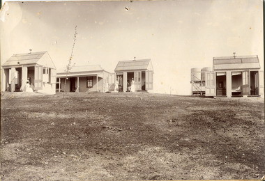
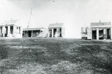
This photograph was captured in approximately 1900 and depicts the on site nurses homes. During the 1880s, these detached cottages were constructed and provided accommodation for the staff (in this case, the nurses) who lived within the hospital walls. Within the image are weatherboard buildings, a number of nurses and water tanks. Beechworth's Mayday Hills was chosen as the site of Victoria's newest asylum, at the time, due to the landscape and altitude. The hilltop atmosphere and the native fauna, it was argued, would assist in the cure of the patients kept at the hospital (Wood 1985, 122). The positioning of the hospital had a beneficial effect on the rural town. A pamphlet published by James Ingram and Son (1849) reveal that famous landmarks in Beechworth which included the Post Office, Gaol, Courthouse and Asylum "demonstrate the appreciation of Beechworth by the Government not only as as important district center, but also as a site unrivaled as a sanitarium". There were other locations in contention at the time, but ultimately Beechworth was chosen (Craig 2000, 33). Prior to the creation of the Asylum in Beechworth, those charged with having mental illnesses or, as it was termed, "insanity" were unable to be properly cared for in the Gaol (which is where they were often sent). John Buckley Castieau wrote, in 1861 for the Ovens and Murray Advertiser, that the Gaol was unable to properly care for those classified then as "insane" but that they would endeavor to treat them above the other inmates (which he notes is not always the case in other establishments). Castieau wrote this in favour of supporting the building of the Mayday Hills Hospital in Beechworth. It was stated that at the time the Mayday Hills Hospital was built, there were 83 prisoners kept in the Gaol who were to be rehoused to the Hospital on the grounds of "insanity". The classification as someone as "insane", in this period of time is a reflection on the inability to cure and understand illnesses of the mind during the mid to late 1800s. Opening on the 24th of October 1867, the Mayday Hills Hospital was originally named the "Ovens Lunatic Asylum", a title which is very much a product of its time. Whilst controversial, changes to the name is part of the history of the Hospital and can provide much insight into the understanding of mental illness throughout history and the use/disuse of this term provides information into the reception/changing opinions of mental illness in society. The Hospital would later become known as the "Mayday Hills Asylum" and/or "Mayday Hills Hospital" with the latter being the most commonly used title. An article in the Ovens and Murray Advertiser notes that on the 7th of March 1865, the foundation stone of the Hospital was laid (it would officially open in 1867) and that it was such a moment of accomplishment and joy for Beechworth that a letter to the editor even suggested that there should be a holiday dedicated to the day the foundation stone as laid. This reveals an extent to which the townspeople of early Beechworth valued the construction of the Hospital in their town. It provided the town with a sense of prestige and honour.At first glance, the remains of the Mayday Hills Hospital in Beechworth, Victoria, inspire tragedy, trauma and beauty. The buildings themselves, with their Italianate style Renaissance architecture designed by J.J. Clark (Craig 2000, 49 & Smith 2016, 203) reflect a bygone period of European and Australian history. The gardens provide a sense of tranquility and beauty. The experience of those within these walls remains a valuable area of study to provide a more complete understanding. This particular hospital is considered the fourth of its like and one of three identified as the largest of their kind. The Mayday Hills Hospital is a sister to the Kew and Ararat Asylums in Melbourne which are both located in relative proximity. Understanding the role of the Mayday Hills Hospital in Beechworth history is integral to understanding the development of the goldfields town, but also for providing important information as to the history of caring for, and the reception of, mental illnesses in Australian and wider European history. Mayday Hills provides a case study which can be researched through oral history, an analysis of the grounds/buildings and through images like these. Images like these depict the strong façade of the Hospital and provide a glimpse into the tranquility of the gardens. This has been done deliberately to provide a sense of comfort and healing about the building to those looking from the outside. Further research into the importance of the Hospital in Beechworth and it's connection to the town will be supported through images like these kept in the Mayday Hills photo album in the collection of the Burke Museum.Black and white rectangular photograph printed on photographic paper mounted on card"Early nurses quarters, Beechworth Mental Hospital, now May Day Hills Hospital."may day hills hospital, nurses quarters, beechworth, mayday hills, asylum -
 The Beechworth Burke Museum
Photograph
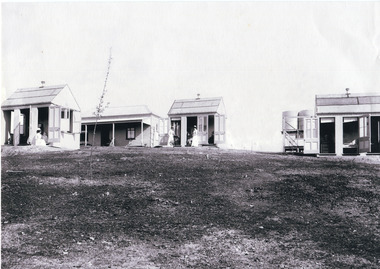
These images are copies of a photograph (3448) captured in approximately 1900 and depicts the on site nurses homes. During the 1880s, these detached cottages were constructed and provided accommodation for the staff (in this case, the nurses) who lived within the hospital walls. Within the image are weatherboard buildings, a number of nurses and water tanks. Beechworth's Mayday Hills was chosen as the site of Victoria's newest asylum, at the time, due to the landscape and altitude. The hilltop atmosphere and the native fauna, it was argued, would assist in the cure of the patients kept at the hospital (Wood 1985, 122). The positioning of the hospital had a beneficial effect on the rural town. A pamphlet published by James Ingram and Son (1849) reveal that famous landmarks in Beechworth which included the Post Office, Gaol, Courthouse and Asylum "demonstrate the appreciation of Beechworth by the Government not only as as important district center, but also as a site unrivaled as a sanitarium". There were other locations in contention at the time, but ultimately Beechworth was chosen (Craig 2000, 33). Prior to the creation of the Asylum in Beechworth, those charged with having mental illnesses or, as it was termed, "insanity" were unable to be properly cared for in the Gaol (which is where they were often sent). John Buckley Castieau wrote, in 1861 for the Ovens and Murray Advertiser, that the Gaol was unable to properly care for those classified then as "insane" but that they would endeavor to treat them above the other inmates (which he notes is not always the case in other establishments). Castieau wrote this in favour of supporting the building of the Mayday Hills Hospital in Beechworth. It was stated that at the time the Mayday Hills Hospital was built, there were 83 prisoners kept in the Gaol who were to be rehoused to the Hospital on the grounds of "insanity". The classification as someone as "insane", in this period of time is a reflection on the inability to cure and understand illnesses of the mind during the mid to late 1800s. Opening on the 24th of October 1867, the Mayday Hills Hospital was originally named the "Ovens Lunatic Asylum", a title which is very much a product of its time. Whilst controversial, changes to the name is part of the history of the Hospital and can provide much insight into the understanding of mental illness throughout history and the use/disuse of this term provides information into the reception/changing opinions of mental illness in society. The Hospital would later become known as the "Mayday Hills Asylum" and/or "Mayday Hills Hospital" with the latter being the most commonly used title. An article in the Ovens and Murray Advertiser notes that on the 7th of March 1865, the foundation stone of the Hospital was laid (it would officially open in 1867) and that it was such a moment of accomplishment and joy for Beechworth that a letter to the editor even suggested that there should be a holiday dedicated to the day the foundation stone as laid. This reveals an extent to which the townspeople of early Beechworth valued the construction of the Hospital in their town. It provided the town with a sense of prestige and honour.At first glance, the remains of the Mayday Hills Hospital in Beechworth, Victoria, inspire tragedy, trauma and beauty. The buildings themselves, with their Italianate style Renaissance architecture designed by J.J. Clark (Craig 2000, 49 & Smith 2016, 203) reflect a bygone period of European and Australian history. The gardens provide a sense of tranquility and beauty. The experience of those within these walls remains a valuable area of study to provide a more complete understanding. This particular hospital is considered the fourth of its like and one of three identified as the largest of their kind. The Mayday Hills Hospital is a sister to the Kew and Ararat Asylums in Melbourne which are both located in relative proximity. Understanding the role of the Mayday Hills Hospital in Beechworth history is integral to understanding the development of the goldfields town, but also for providing important information as to the history of caring for, and the reception of, mental illnesses in Australian and wider European history. Mayday Hills provides a case study which can be researched through oral history, an analysis of the grounds/buildings and through images like these. Images like these depict the strong façade of the Hospital and provide a glimpse into the tranquility of the gardens. This has been done deliberately to provide a sense of comfort and healing about the building to those looking from the outside. Further research into the importance of the Hospital in Beechworth and it's connection to the town will be supported through images like these kept in the Mayday Hills photo album in the collection of the Burke Museum.Black and white rectangular photograph printed on gloss photographic papermental hospital, mayday hills, beechworth, copy, nurse, nurses quarters, on-site dwelling, 1900s, 1880, beechworth asylum -
 The Beechworth Burke Museum
Photograph
This photograph is a copy of that captured in approximately 1900 and depicts the on site nurses homes. During the 1880s, these detached cottages were constructed and provided accommodation for the staff (in this case, the nurses) who lived within the hospital walls. Within the image are weatherboard buildings, a number of nurses and water tanks. Beechworth's Mayday Hills was chosen as the site of Victoria's newest asylum, at the time, due to the landscape and altitude. The hilltop atmosphere and the native fauna, it was argued, would assist in the cure of the patients kept at the hospital (Wood 1985, 122). The positioning of the hospital had a beneficial effect on the rural town. A pamphlet published by James Ingram and Son (1849) reveal that famous landmarks in Beechworth which included the Post Office, Gaol, Courthouse and Asylum "demonstrate the appreciation of Beechworth by the Government not only as as important district center, but also as a site unrivaled as a sanitarium". There were other locations in contention at the time, but ultimately Beechworth was chosen (Craig 2000, 33). Prior to the creation of the Asylum in Beechworth, those charged with having mental illnesses or, as it was termed, "insanity" were unable to be properly cared for in the Gaol (which is where they were often sent). John Buckley Castieau wrote, in 1861 for the Ovens and Murray Advertiser, that the Gaol was unable to properly care for those classified then as "insane" but that they would endeavor to treat them above the other inmates (which he notes is not always the case in other establishments). Castieau wrote this in favour of supporting the building of the Mayday Hills Hospital in Beechworth. It was stated that at the time the Mayday Hills Hospital was built, there were 83 prisoners kept in the Gaol who were to be rehoused to the Hospital on the grounds of "insanity". The classification as someone as "insane", in this period of time is a reflection on the inability to cure and understand illnesses of the mind during the mid to late 1800s. Opening on the 24th of October 1867, the Mayday Hills Hospital was originally named the "Ovens Lunatic Asylum", a title which is very much a product of its time. Whilst controversial, changes to the name is part of the history of the Hospital and can provide much insight into the understanding of mental illness throughout history and the use/disuse of this term provides information into the reception/changing opinions of mental illness in society. The Hospital would later become known as the "Mayday Hills Asylum" and/or "Mayday Hills Hospital" with the latter being the most commonly used title. An article in the Ovens and Murray Advertiser notes that on the 7th of March 1865, the foundation stone of the Hospital was laid (it would officially open in 1867) and that it was such a moment of accomplishment and joy for Beechworth that a letter to the editor even suggested that there should be a holiday dedicated to the day the foundation stone as laid. This reveals an extent to which the townspeople of early Beechworth valued the construction of the Hospital in their town. It provided the town with a sense of prestige and honour.At first glance, the remains of the Mayday Hills Hospital in Beechworth, Victoria, inspire tragedy, trauma and beauty. The buildings themselves, with their Italianate style Renaissance architecture designed by J.J. Clark (Craig 2000, 49 & Smith 2016, 203) reflect a bygone period of European and Australian history. The gardens provide a sense of tranquility and beauty. The experience of those within these walls remains a valuable area of study to provide a more complete understanding. This particular hospital is considered the fourth of its like and one of three identified as the largest of their kind. The Mayday Hills Hospital is a sister to the Kew and Ararat Asylums in Melbourne which are both located in relative proximity. Understanding the role of the Mayday Hills Hospital in Beechworth history is integral to understanding the development of the goldfields town, but also for providing important information as to the history of caring for, and the reception of, mental illnesses in Australian and wider European history. Mayday Hills provides a case study which can be researched through oral history, an analysis of the grounds/buildings and through images like these. Images like these depict the strong façade of the Hospital and provide a glimpse into the tranquility of the gardens. This has been done deliberately to provide a sense of comfort and healing about the building to those looking from the outside. Further research into the importance of the Hospital in Beechworth and it's connection to the town will be supported through images like these kept in the Mayday Hills photo album in the collection of the Burke Museum.Black and white rectangular photograph printed on photographic paper mounted on cardmayday hills, nurse, weatherboard, watertank, mayday hills hospital, asylum, mental health, kew, ararat, mental hospital, beechworth, gold town -
 The Beechworth Burke Museum
Photograph - Photograph Reproduction, 1998
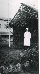
The photograph, created in 1998, is a copy of the original one, depicting a nurse in uniform at the Mental Hospital in Beechworth, with a fern house behind her. In the background, the two-storey building is in view, along with the covered walkway. The institution had to operate with serious shortage of female nurses for long periods of time. During the 1880s, small houses (cottages) were built to offer accommodation for the nurses living in the hospital and in 1937 began the construction of a nurses` hostel. In 1962 the upper level of the Nurses` Home was converted into a Nurses` Training School. The Mayday Hills Hospital was constructed between 1864 and 1867, with buildings created in a number of periods. It formally opened on 24 October 1867 and, along with the Ovens Hospital and the Benevolent Asylum, made Beechworth a prominent social welfare centre in Victoria. The need for an institution of this kind was arisen due to the increased number of people with mental disturbances (induced by the harsh living conditions on the goldfields) and the remoteness of the district from Melbourne. The two-storey buildings, designed in Italianate style, and the three-storey towers at the front, were influenced by the asylum at Colney Hatch in England. Large masses of granite were excavated for its foundation and around 250 workmen were employed for its construction. The building, divided into six sections, was comprised of dormitories, doctors` rooms and plenty ancillary rooms and facilities, such as laundries, reading rooms, a concert hall and cooking areas. The site was chosen for its panoramic view of the countryside, the hilltop atmosphere and the native fauna, all contributing to the cure of patients. The Hospital was originally named the “Ovens Lunatic Asylum” but, during the centenary celebrations in 1967, the name was officially changed to “Mayday Hills Hospital”, showing the gradual shift in the perception and understanding of mental health conditions over the last decades. The Hospital lies on the traditional land of the Kulin Nation.This photograph is historically significant as it provides an insight into the everyday life of staff living within the walls of the Mayday Hills Hospital. It also offers important information about the location and the exterior of the Hospital and contributes to the understanding of the district`s development and its importance to the course of Victoria`s history.Black and white rectangular photograph printed on paper unframed.Reverse: 3445/mental hospital, beechworth, fern house, female nurses, nurses` home, nurses` training school, nurses` hostel, mayday hills hospital, ovens hospital, colney hatch, two-storey buildings, italianate style, benevolent asylum, ovens lunatic asylum, kulin nation, workmen, covered walkway, granite, hilltop atmosphere, mental health -
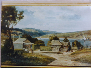
 Flagstaff Hill Maritime Museum and Village
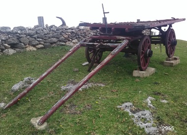
Wagon, circa 1850s
Bostock & Manifold were all from pioneering families in the Western District of Victoria almost from the time of settlement. Family history: The Bostock family were prominent in Warrnambool from the 1850s to the 1880s. Patriarch Robert Bostock had in 1813 been transported to Sydney from Sierra Leone for having 'felonious traded in slaves' and sentenced to 14 years transportation. He moved to Tasmania in 1821 where he died in 1847. A number of his children came to Port Phillip. Edward Robert Bostock held the Jellabad run from 1849 to 1853. George Bostock (1826-1858) was a Warrnambool Shire Councillor in 1856. Thomas Edward Bostock (1828-1874) was a Shire Councillor in the late 1860s. Augustus Bostock (1833-1920) lived in Warrnambool. Augustus Bostock was the 9th child of Robert and Rachael Bostock of Vaucluse Epping Forest, Van Diemen's Land. He was only 4 years old when his mother died. He was inspired by his father to seek his fortune in the Western District of Victoria. He arrived around 1850. He married Margaret Aitkin in July 1865. Augustus owned several properties in the district and leased others. He sat on the court of Warrnambool, Mortlake or Hexham as required. He resided at Marramook in Hawkesdale and later moved to Vaucluse in Hopetoun Road Warrnambool, where he died in 1920 at the age of 87. The Wagon is significant locally and state wide for its association with Augustus Bostock who was involved in many aspects of life in the Western District of Victoria, racing, cricket, and social activities to name a few. Bostock & Manifold were all from pioneering families in the Western District of Victoria almost from the time of settlement. The wagon is significant for its historical and economic association with the local Warrnambool business of Manifold & Bostock. These men had leased and owned vast tracts of land and operated businesses around the district together at various times often associated with the farming industry. One example is the Manifold & Bostock store and flour mill from which the wagon dray is believed to have been associated with for the delivery of goods. Their flour mill began operation in 1850 in 7-17 Stanley St South Warrnambool and was known as “Jetty Mills” Manifold and Bostock in 1858 purchased the Mill from John and G Elliot (brothers) with half an acre of ground and a cottage for £1600. It appears addresses of the company changed over the years as the town grew. These are listed in “Jones, Lewis & Peggy flour mills of Victoria” showing the company operating from, Fairy Street and later at the Merri River near the cutting, known as Banyan and Merri Streets. The company ceased trading in 1870. The Wagon Dray is also an example of agricultural freight and general transportation during the 1800 and 1900 century.A four-wheeled wooden horse-drawn wagon with flat top described as a Wagon Dray in historical writings. Painted brown and black. The wagon has rear brakes, wooden, operated from a metal handle at the front of the Wagon. Front wheels are attached to a turnstile to allow easy turning of the wagon. This flat-topped, horse driven, four-wheeled Wagon was used for cartage by the business of Manifold & Bostock, Warrnambool. The original sign writing of the wagon is obscured or painted over. There is a feint mark of lettering to the sides and back edges of the cart Manifold & Bostock. "Manifold and Bostock" very feintflagstaff hill, warrnambool, shipwrecked-coast, flagstaff-hill, flagstaff-hill-maritime-museum, maritime-museum, flagstaff-hill-maritime-village, cartage, manifold and bostock of warrnambool, manifold family of western victoria, bostock family of western victoria, four wheeled wagon, wagon, horse drawn wagon, farm wagon, aitkin, aitkin bostock manifold, dray, aitkin family, cart, aitken, flour mill -
 Flagstaff Hill Maritime Museum and Village
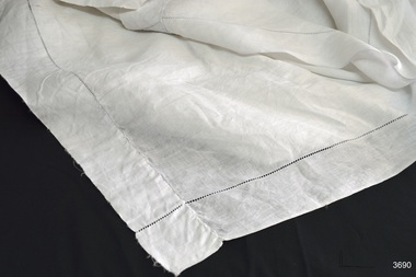
Textile - Tablecloth, late 19th century
The linen tablecloth has been hand worked using satin stitch embroidery and drawn thread work. This tablecloth is one of many 19th century items of furniture, linen and crockery donated to Flagstaff Hill Maritime Village by, Vera and Aurelin Giles. The items are associated with the Giles Family and are known as the “Giles Collection”. Most of the items in this Collection are in the Lighthouse Keeper’s Cottage at Flagstaff Hill. The majority came from the simple home of Vera’s Giles’ parents, Henry Giles and his wife Mary Jane (nee Freckleton), whose photographs are in the parlour. They married in 1880. Henry Giles was born at Tower Hill, Victoria in 1858 and worked as a labourer on the construction of the Warrnambool Breakwater. His wife, Mary Jane, was born in 1860 at Cooramook. She attended Mailor’s Flat State School, and later worked there as a student teacher, before (as family legend has it) she became a governess at “Injemira” where her grandfather, Francis Freckleton, owned the land. The Giles family of six, some of whom were born at Mailor’s Flat and the younger at Purnim West, lived at “The Maam”, Wangoom before moving to New South Wales in 1895, where Henry built bridges for about 7 years. Henry died in 1933 and Mary Jane died in 1940. The Giles family collection has social significance at a local level, because it illustrates the level of material support the Warrnambool community gave to Flagstaff Hill when the Museum was established.Tablecloth, white linen, part of the Giles Collection. Large white rectangular tablecloth, hand embroidered using white thread. Floral design in satin stitch and drawn threadwork. Cloth has additional white cloth iron-on label.Iron-on label, hand written in black pen "LHK B22". flagstaff hill, warrnambool, shipwrecked coast, flagstaff hill maritime museum, maritime museum, shipwreck coast, flagstaff hill maritime village, great ocean road, giles family, cooramook, 19th century linen, 19th century household goods, 19th century handcraft, 19th century manchester, 19th century table linen, 19th century tablecloth, giles family collection, 19th century household linen, warrnambool breakwater construction -
 Flagstaff Hill Maritime Museum and Village
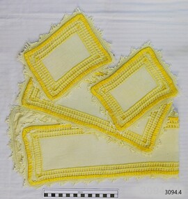
Textile - Runners, Mary Jane Giles (Mrs Harry Giles), Late 19th to Early 20th Century
This hand crafted set of runners is one of many 19th century items of furniture, linen and crockery donated to Flagstaff Hill Maritime Village by, Vera and Aurelin Giles. The items are associated with Warrnambool and the Giles Family history. Items donated by the family have come to be known as the “Giles Collection”. Many items in the Lighthouse Keeper’s Cottage were donated by Vera and Aurelin Giles and mostly came from the home of Vera’s parents-in-law, Henry Giles and his wife Mary Jane (nee Freckleton) who married in 1880 and whose photos are on display in the parlour. Henry was born at Tower Hill in 1858, and was a labourer on the construction of the Warrnambool Breakwater before leaving in 1895 for around seven years to build bridges in NSW. Mary Jane was born in 1860 at Cooramook and she attended Mailor’s Flat State School and where she eventually was to become a student teacher. After which she became a governess at “Injemiara” where her grandfather, Francis Freckleton, had once owned land. Henry and Mary’s family consisted of six, some of the children were born at Mailor’s Flat and later some children at Wangoom. They lived with their parents at Wangoom and Purnim west, and this is where Henry died in 1933 and Mary Jane in 1940.The Giles family collection is of social significance at a local level, because it not only illustrates the level of material support the Warrnambool community gave to Flagstaff Hill during it’s establishment. But the Giles collection also gives us today a snapshot into what domestic life was like in early colonial times prior to Federation.Set of four lined and embroidered runners and doilies, white with yellow huckaback embroidery, crochet fringe. The smaller runner has a small same-fabric patch in one corner with a label attached to it. (Giles Collection)."LHK / PAB" flagstaff hill, warrnambool, shipwrecked coast, flagstaff hill maritime museum, shipwreck coast, flagstaff hill maritime village, great ocean road, giles family, henry giles, cooramook, mailor’s flat, wangoom, 19th century linen, 19th century handcraft, textiles -
 Bendigo Military Museum
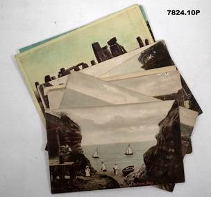
Postcard - POSTCARDS, PHOTOGRAPHIC, VARIOUS U.K, c. WW1
Postcards collected by R.H. Baron while on leave in England during WW1. Part of the "Robert H. Baron" (No. 3596) and Cooper Collections. See Catalogue No. 1981P for details of Baron's service. 1. Coloured coastal scene featuring yachts, beach goers and cliffs. People are standing on a pebbled beach. 2. Coloured coastal scene featuring cliffs and ocean. 3. Coloured coastal scene featuring beach, bathing machines, cliffs and town buildings. 4. Coloured coastal scene featuring beach with boats and town buildings. 5. Sepia toned photograph featuring houses. Stream running in front of house. Footpath between stream and house. 6. Coloured street scene featuring houses fronting a gravel road. 7. Black and white photograph of a street scene featuring buildings, pedestrians and horse drawn transport. 8. Sepia toned photograph of a street scene. Right side lined with houses. Single pedestrian on footpath. 9. Coloured scene featuring standing stones. 10. Coloured photograph of a ruined building overgrown with vegetation.1. Ladram Bay. 2. Ladram Bay. 3. Budleigh Salterton from East. 4. Budleigh Salterton from West. 5. Budleigh Salterton, Cottages at the Granery, 6. Budleigh Salterton, West Terrace. 7. High St. Budleigh Salterton. 8. Budleigh Salterton, Station Road. 9. Stonehenge. 10. Abbey Ruins, Waverley. robert h. baron, cooper collection, postcards, ww1 -
 Warrnambool and District Historical Society Inc.
Flyer - Embroiders Guild South West District
This leaflet lists five pieces of embroidery made by the South Western Branch of the Embroiderers Guild of Victoria and presented to the City of Warrnambool, one piece made for Flagstaff Hill Maritime Village, one piece containing the names of 170 members of the branch and one piece made for the Jones Foundation. The South Western Group of the Embroiderers Guild of Victoria was formed in Warrnambool in 1974. In 1976 they presented their first public piece of embroidery, a patchwork quilt for the Lighthouse Keepers’ Cottage to Flagstaff Hill Maritime Village .This leaflet is useful for its summary of the embroideries completed by the local embroidery branch involving many of its members. This is a four page leaflet depicting eight works of embroidery made by the Embroiderers Guild of Victoria, South Western Branch. The eight embroidery pieces are displayed in colour with written material attachedFront cover: Embroidery in Warrnambool, Victoria, Australia, The Embroiderers Guild (logo), A guide to the embroideries completed by The Embroiderers Guild, Victoria, South Western Branch, P.O. Box 433 Warrnambool 3280, W.C.C. Logo and a 50 year logo embroiderers guild, south western branch, warrnambool -
 Warrnambool and District Historical Society Inc.
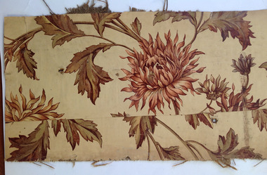
Textile - Wallpaper, Wallpaper fragment 1854, c1854
Wallpaper fragment from an early workman's cottage in Weller St, Geelong West built in 1854. This property was refurbished following its sale in the early 1990s. Over time many layers of wallpaper had been pasted to the original paper. The wallpaper was damp and hanging off the walls. It was removed to reveal packing case 'slats' on the stud wall. When the skirting board was removed the original wallpaper was revealed. Although not a Warrnambool artefact, the Weller St property was owned by a local resident. It shows the wallpaper design of the period and the manner in which wallpaper was attached in the mid 19th century.Wallpaper fragment with maroon flowers and olive green leaves on a bone-coloured background mounted on hessian backinggeelong west, weller st, workman's cottage, interior decoration, wallpapers -
 Warrnambool and District Historical Society Inc.
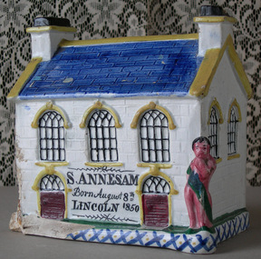
Decorative object - Esam Money Box, 1850
This money box is believed to be an antique Prattware piece modelled on a n English Methodist Chapel. It was a gift to a young girl, Sarah Ann Esam born in 1850 in Lincoln, England. Her parents John and Ann Esam emigrated to Australia in 1865 with six children one of whom was Sarah. John Esam became well known in Warrnambool as an engineer and windmill maker. His best known windmill is the one he made for "Lyndoch". Sarah Ann Esam died in Henna Street, Warrnambool in April 1915 on Easter Monday. This money box is of considerable significance because of its age, its artistic attractiveness and its connection to the Esam family who were prominent in Warrnambool in the 19th century. This glazed piece of pottery is a child's money box modelled on an English Methodist Chapel. It has a blue tiled roof with yellow edges, a slot for coins at the back.and two chimneys at each end of the building. The primary colour of the cottage is white It has two storeys, the upper one has six lead light windows framed with yellow and the ground storey has two brown doors with lead light fan windows. There is a pink colored figure standing in one corner of the base. The base is green representing grass. The edges of the base feature blue crosses interspersed with yellow dots. The black inscription on the front is artistically written. One chimney is damaged.as are the four base corners. S. ANN. ESAM. Born August 8th LINCOLN 1850esam, money box, prattware -
 Warrnambool and District Historical Society Inc.
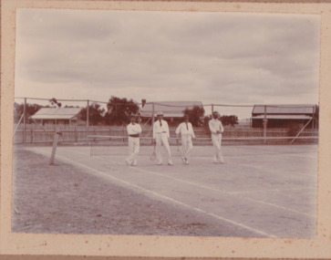
Photograph, 4 Male tennis players, 1900
People are unknown as is the area. Stubbs. F. J Stubbs operated as a photographer in Victoria between 1858 and 1908. G. U. Petterd as picture framer operated from Timor Street. He also acted as a house, land and commission agent and dealt in books, fine arts and toys. This photograph is a tangible link to a business which operated as a family business for many years in Timor Street Warrnambool.Black and white photograph depicting 4 men standing at the net on a tennis court. All are in long sleeve shirts and long white trousers and shoes. High timber framed fence behind them, behind which is a picket fence and 3 cottages. Glued and double mounted in cream and grey.Stubbs imprinted in lower right side of photo and lower left of cream mount. G. U. Petterd picture framer and plush worker Warrnambool, stamped on rear. Handwritten in pen on rear11/4/00warrnambool, stubbs, petterd, photographer, picture framer, 1900 tennis players -
 Warrnambool and District Historical Society Inc.
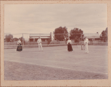
Photograph, 4 Mixed Tennis players, 1900
People are unknown as is the area. Stubbs. F. J Stubbs operated as a photographer in Victoria between 1858 and 1908. G. U. Petterd as picture framer operated from Timor Street. He also acted as a house, land and commission agent and dealt in books, fine arts and toys. This photograph is a tangible link to a business which operated as a family business for many years in Timor Street Warrnambool.Black and white photograph depicting two male and two female tennis players.High timber framed fence in background with picket fence and two cottages behind the fence. The men are dressed in white and the ladies are in white tops and dark skirts with straw boater hats. Stubbs imprinted on lower Left corner of photograph. “G U Petterd Picture framer and plush worker Warrnambool” in purple stamp on rear. Taken 11/4/00 in black ink on back upper right.warrnambool, g u petterd, stubbs, tennis players, 1900, mixed tennis players. -
 Warrnambool and District Historical Society Inc.
Photograph, Old Lyndoch - Photograph of Painting, Late 19th century (original painting); late 20th century (photograph of painting)
This is a photograph of a painting by the noted artist George Webb (1861-1949). Webb was best known for his portraits of civic dignitaries in Melbourne and Adelaide but he also produced many landscapes and seascapes. Some of these feature Warrnambool landmarks as he married, in the late 1890s, Christina Lake, the step-daughter of George Rolfe who owned the property known as ‘Lyndoch’, near the mouth of the Hopkins River. Webb painted the early cottages at ‘Old Lyndoch’ using a photograph taken some time earlier. The painting was given to Dick Allan, the chauffeur in the employ of Florence Lake, Christina’s sister. Florence Lake owned and resided at Lyndoch after her parents’ death. Dick Allan’s son, living in Tasmania, acquired the painting and Les O’Callaghan obtained the photograph of the painting from him. Although this is only a photograph of an original painting, it is of some considerable importance as the painting has great historical significance and this is the only representation we have of it. The man in the photograph represents George Rolfe and the story of Rolfe and his ownership and development of the property of Lyndoch is an important one in Warrnambool’s history. The original by George Webb is also an important work of art in its own right.This is a colour photograph of a painting. The frame of the original painting can be seen at the bottom of the photograph. The photograph is in on old frame which has two wooden edgings with the outer one having an ornate gold plaster edging and an inner one with a gold velvet insert next to the glass. The ornate gold plaster has a piece missing near the top left hand corner. The photograph is set into a gold-coloured wooden frame inside the glass. The photograph is mounted onto cardboard and covered with cardboard at the back with a small piece of wood attached (from the original frame). The backing is nailed on. lyndoch, george webb, george rolfe -
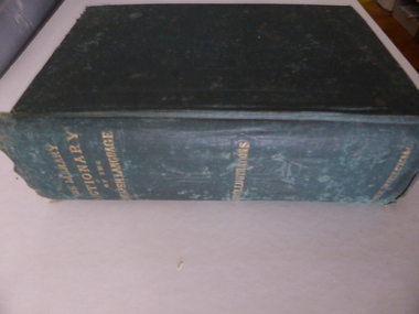 Warrnambool and District Historical Society Inc.
Book, The library dictionary of the Eng language
This dictionary belonged to John Brass, an early settler in South Warrnambool. He owned several block of land and operated a lighterage business with John Young. As a lighterman and boatman he was well-known in Warrnambool. He was drowned in March 1895 while attempting to cross a temporary foot bridge across the Merri River. His house (probably in Stanley Street) was built in 1868 and remained as an interesting example of a lighterman’s cottage until1974. The dictionary probably became the property of W. Macdonald after John Brass’ death. No information has been found on this W. Macdonald. This book is of interest as it belonged to John Brass, an important early settler in South Warrnambool. This is a hard cover book of 974 pages. The cover is green with embossed patterning and lettering on the front cover and gold lettering on the spine. The book has a Preface, a Contents page, the Dictionary entries and an Appendix. There are many illustrations, from engravings on wood, scattered throughout the text. The cloth binding is coming loose and there are several loose pages. The last page is missing. The inscriptions are written in pencil and in blue ink and there are red stamps of John Brass. The cover is stained and faded. ‘John Brass, South Warrnambool, Victoria, Aust- 1893’ ‘June 5 x 6 x 93’ ‘J.Brass, Jetty’ Stamps – ‘John Brass, South Warrnambool’ ‘W.J. Macdonald, Moyston, Dec.23-11-95’ ‘W.J.McDonald’ john brass, history of south warrnambool, w. macdonald (moyston), warrnambool’s maritime history -
 Warrnambool and District Historical Society Inc.
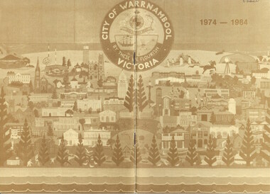
Booklet - Embroiderers Guild, 1984
This booklet, written by member Rita Williams, gives information on the history of the first decade of the South Western Embroiderers Guild, Warrnambool. The guild was formed in 1974 with an initial membership of 36. In the first ten years the guild members were active, making contact with other embroiderers, holding exhibitions, making a patchwork quilt for the bed at the Lighthouse Keepers’ Cottage at Flagstaff Hill Maritime Museum and making an embroidered mural of Warrnambool presented to the Warrnambool Regional Performing Arts Centre in 1983. This mural features over 80 local buildings, Norfolk Island pines and small figures and other objects. The Embroiderers Guild continues to prosper today. This booklet is of interest as it contains the early history of the South Western Embroiderers Guild, a significant organization in Warrnambool. This is a booklet of 24 pages with a cover in brown and cream tonings featuring an image of the Warrnambool Coat of Arms and a tapestry. The pages contain a sketch and printed material. The booklet was stapled but the staples have been removed.R.Isaacsouth western embroiderers guild, warrnambool, history of warrnambool -
 Warrnambool and District Historical Society Inc.
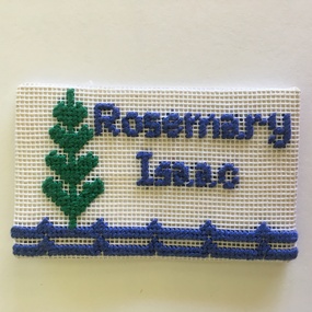
Badge, Rita Williams (designer), South Western Branch Embroiders Guild, late 20th century
This name badge belonged to Rosemary Isaac, a member of the South Western Branch of the Embroiderers Guild of Victoria. The badge, designed by long-time member Rita Williams, shows a Norfolk Island pine tree and a fence line. The South Western Branch of the Embroiderers Guild of Victoria was formed in Warrnambool in November 1974. Its first major project was the making of a patchwork quilt for the Lighthouse Keepers cottage at Flagstaff Hill. This was presented to the Warrnambool and District Historical Society at a meeting of the Embroiderers Guild attended by Historical Society members and representatives of Flagstaff Hill Maritime Village in October 1976. This badge is kept as a memento of the work of the local Embroiderers Guild, a prominent community organization in Warrnambool and district.This is a rectangular-shaped cloth badge with blue and green stitching on a white cloth surface. ‘Rosemary Isaac’south western group of the embroiderers guild of victoria -
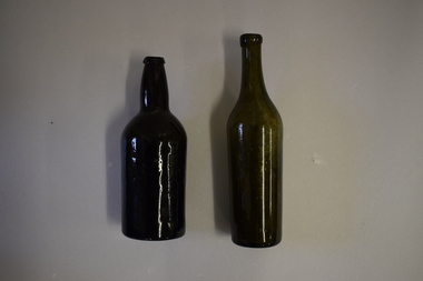 Warrnambool and District Historical Society Inc.
Bottles (2), Bottle, c. 1900
These two bottles were found by workmen building a new retaining wall on the north side of the Les O’Callaghan History House building in Gilles Street Warrnambool. The wall replaced one damaged beyond repair following a car accident in 2019. The building was erected in 1889 as the caretaker’s cottage in the Warrnambool Sea Baths complex (for most of its existence it had two swimming pools, a hot sea water baths building and a caretaker’s cottage). The water in the baths were pumped up from the ocean and, for the hot baths, heated on site. These baths were the municipal baths until the mid 1950s. The bottles may have originated from the one of the families residing in the cottage or from passers-by in the adjoining Merri Street or from patrons of the baths. They appear to be over 100 years old but there is no way the ownership of the bottles can be established.These bottles are of interest as archeological finds after repair works to the Les O’Callaghan History House. .1 A dark green (or black?) glass bottle with a hollowed out concave base, no stopper and a slightly chipped rim on the top. The bottle is stained inside. .2 A green glass bottle with a hollowed out concave base, a moulded top with no stopper and an elongated neck. The bottle is stained inside. warrnambool & district historical society, heritageworks warrnambool, les o’callaghan history house, warrnambool, history of warrnambool -
 Warrnambool and District Historical Society Inc.
Book, Amazon Printing, William Francis Brebner 1880-1852, 2018
This book documents the lives of William and Agnes Brebner and family. William’s father, Isaac had come to Warrnambool in the 1860s and had a tailoring business in the town. By the beginning of the 20th century he was the caretaker at the Sea Baths in Gilles Street, Warrnambool and the family lived in the caretaker’s cottage (Les O’Callaghan History House today). William Brebner established a paint shop in Timor Street in 1916 and this prominent business remained in the Brebner family until 1977. It continued in other hands until the early years of the 21st century. This book is of significance as it documents the life and times of William Brebner and his family. The Brebners have been important, particularly in the 20th century, in the business and community world of Warrnambool.This is a soft cover book of 132 pages. It has a blue cover with a black and white photograph of William Brebner and black printing on the front cover. It has four sections – one on the life of William Brebner and his wife and family, one on his ancestors and two on his descendants. The book contains many black and white and colour photographs.brebner family,, history of warrnambool -
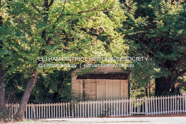
 Eltham District Historical Society Inc
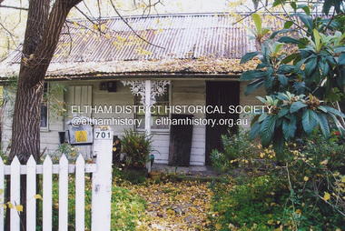
Photograph, Fay Bridge, Former Jarrold Cottage and Bootmaker's Shop, 701 Main Road, Eltham, n.d
Situated originally on the corner of the Dalton Street road reserve west of Main Road (now present-day Wingrove Park Trail), the former Jarrold Cottage (White Cloud) was purchased by Lena Skipper following Thekla Jarrold's death in 1943. It was built by William Jarrold in the early 1850s and was here that he married Hannah Coleman in 1856. The Bootmaker's shop was built by Thekla Jarrold in 1930 for use by her friend, John Clark, a local photographer who had boarded with the Jarrold family since about 1910. In 1930 he changed profession to a bootmaker and leather worker. The shop is one of only three remaining early 20th century shops in what was Little Eltham, the others being present-day San Antionio Barber Shop at 820 Main Road and Cafe Zen Den at 736 Main Road.fay bridge collection, bootmaker's shop, eltham, jarrold cottage, main road, shops, white cloud cottage, wingrove park trail -
 Eltham District Historical Society Inc
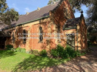
Photograph, Jim Connor, Eltham - Montmorency Uniting Church, 810 Main Rd, Eltham, 10 July 2023
Located on the corner of Main Road and John Street, the church first served the community as the Eltham Wesleyan Church since 1881. It became the Eltham Methodist Church in 1902, the year it united with the Primitive Methodists. Eltham Wesleyans first worshipped together in the home of William and Mary Crozier, on 24 acres bounded by Mount Pleasant Road and Pitt Street. From there they moved to a slab and bark hut in 1855 (this later served as the first school run by David Clark prior to the building of a new school in Dalton Street) and the members then built a chapel in 1858 on Lot 20, Henry Street (later to become the Rechabite Hall and Eltham Public Hall). The present church on John Street was designed by architects Crouch and Wilson in the Early English Gothic style with biochrome brick window frames, buttress heads and pinnacle. Church member George Stebbing built the church, the foundations were constructed with stone from the walls of the first Eltham State Primary School (No. 209) building which collapsed in 1874 and were purchased by Robert David Taylor. Stebbing was also responsible for building St Margaret’s Church and Shillinglaw Cottage. The Roll of Honour, which presently hangs in the church hall (which also doubles as the Opportunity Shop) lists 27 members of the congregation who served in the First World War, 11 of whom never returned. The red-brick Church Hall was opened in 1931 and in 1971 further additions linked the hall and church, including a foyer, vestry, meeting room and toilets reflecting the Eltham style of that time with its simplicity, extensive clear glass, reused baked clay-bricks from the 1881 church, heavy ceiling beams and compressed straw ceiling. On June 26, 1977, the church became part of the new Uniting Church in Australia consisting of the former Methodist and Congregational and most of the Presbyterian Churches. Following of declining numbers of worshippers, the church merged with the Montmorency Uniting Church on June 23, 1996. In 2023 the Uniting church approved a plan to renovate the church. It is understood that the historic church and the hall will be retained, and the building added in 1971 is to be demolished, to make way for a new purpose-built Opportunity shop. The proposed areas to be demolished include the current foyer, toilets, crèche, etc, including the area between the hall and the former RSL. Works are expected to commence mid to late July 2023. The Society was invited by a church member to take photographs of these areas to document them prior to demolition works commencing. Ref: “Nillumbik Now and Then” by Marguerite Marshall (2008)jim connor collection, 2023-07-10, eltham-montmorency uniting church, john street, methodist church, opportunity shop, uniting church, uniting church hall -
 Eltham District Historical Society Inc
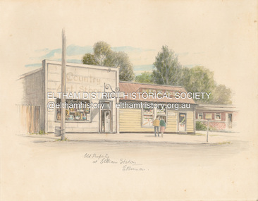
Artwork, other - Sketch, E. Foreman, Old property at Eltham Station, c.1980
Situated at 965 Main Road adjacent to the Eltham Railway Station, the Country Art Store was originally a hairdresser and Tattersalls agency In 1968 Pam Robinson and Caroline Shenton opened a small shop on the corner of Main Road and Napoleon Street. Four months later a damaged fire hyrdant flooded the store and ruined all their stock. The pair moved to the former hardresser shop at 965 Main Road, adjacent to the Eltham Railway Station, opposite the Stationmaster's house and opened the Country Art Store and adjacent gallery. At the time the only other shop selling pottery was the Potters Cottage in Warrandyte. During the 1970s the gallery was the Wiregrass Gallery. In 1993, after 25 years operating the Country Art Store, the pair decided to sell up and move to warmer climates. During the course of their business a number of craft shops and galleries opened and closed in Eltham. One such shop was Bimbadeen, next to Ansell and Muir's chicken shop opposite Eltham Lower Park. That business run by Don Brown, then a local artist was taken over as River Clay run by Leo Haanappel and Coeny Dommers but ultimately sat in a flood plain and was demolished. When the Country Art Store became available in 1993, Leo Haanappel and Coeny Dommers took it over. The premises became Platform 3095 cafe around 2015.Old Property at Eltha Station E. Foremanart store, country art store, country art store (eltham), eltham railway station, platform 3095, restaurants, shops, wiregrass gallery -
 Eltham District Historical Society Inc
Photograph (Item) - Print, Craig Price, Old Bootmakers Shop in Main Road, Eltham - Eltham's history worth preserving, 1988
701 Main Road, Eltham Situated originally on the corner of the Dalton Street road reserve west of Main Road (now present-day Wingrove Park Trail), the former Jarrold Cottage (White Cloud) was purchased by Lena Skipper following Thekla Jarrold's death in 1943. It was built by William Jarrold in the early 1850s and was here that he married Hannah Coleman in 1856. The Bootmaker's shop was built by Thekla Jarrold in 1930 for use by her friend, John Clark, a local photographer who had boarded with the Jarrold family since about 1910. In 1930 he changed profession to a bootmaker and leather worker. The shop is one of only three remaining early 20th century shops in what was Little Eltham, the others being present-day San Antionio Barber Shop at 820 Main Road and Cafe Zen Den at 736 Main Road. Craig Price 1988 Entrant No. 148 Ref: Series 34, Items 37, 38, 109, 110 SHIRE OF ELTHAM COMMUNITY PHOTOGRAPHIC SURVEY Photography is an artform which many of us practice, sometimes purely for artistic pursuit, sometimes to record the people and events in our lives. In 1988, as part of a local Bicentennial project, the Shire of Eltham conducted the Eltham Community Photographic Survey. Up to 100 entries were to be selected by a panel of photographers for entry into the Eltham Photographic Survey Exhibition. Entries had to be submitted by May 13, 1988. Entrants whose images were selected for the exhibition were contacted and requested to further submit an entry form providing entrant’s name, area of residence, age, and proposed captions. These details were then used to produce labels for the exhibition mounts. Where negatives had not been supplied, these were requested to support the display of printed enlargements mounted on 10” x 8” cardboard. The mounted prints were made available post exhibition for sale at $8.50 each for colour prints and $7.00 for B&W prints. Residents in the Shire were invited to collect a free roll of film and take a photograph of what they either liked or did not like about the area. A total of 160 entrants submitted multiple entries for the exhibition. Of those selected for exhibition, entrants ranged in age from 9 to 70 years. All custom colour and black and white printing for the exhibition was completed by Wattle Studios of Eltham. The Eltham Photographic Survey was jointly auspiced by the Shire of Eltham and Wattle Studios, of 953 Main Road, Eltham. The project was greatly assisted by: • David McRitchie, Media Studies Lecturer Victoria College, Rusden Campus. • Ian and Annette Toohill of Wattle Studios • Tracy Naughton, Eltham Community Arts Officer • Neville Emerson Pty. Ltd. • Superior Press, Eltham • Kodak Australasia Pty. Ltd. • Agfa Gevaert Ltd. • Townsend Colourtech Pty. Ltd. • The Australian Bicentennial Authority • Eleanor Bowers, Secretary, Eltham Arts Council The exhibition was placed on display in the Woolworths Arcade, Eltham between Monday June 6th and Saturday June 11, 1988. It was also intended to hold the exhibition at a venue in the Shire’s North Riding from Monday, June 20 to Friday June 24. It was then displayed at the Were Street Theatre, Montmorency from Friday, June 24 to Thursday, July 7. Series 34: Eltham Community Photographic Survey 1988 - Prints & Documentation Series consists of 117 photographs of Shire scenes taken by members of the community. Items I - 41 are larger photographs mounted on card, which were exhibited. Items 42 - 117 are unmounted copies, alternative takes and other entries. Corresponding negatives contained in Series 35: Eltham Community Photographic Survey 1988 – Negatives which consists of 267 colour and B&W negatives and one colour slide of Shire scenes taken by members of the community. The negatives are arranged by the entrant number of the photographer. The Eltham Community Photographic Survey collection is significant to the local community as it was curated by the local community - ordinary people of all ages - representing what they liked and did not like in the area where they lived. It represents an unfiltered representation of the Shire of Eltham as it was in 1988. It also represents one of many projects as part of the national programme of events and celebrations to commemorate the bicentenary. It is a time capsule of life in the 1980s of this urban and rural municipality in Melbourne's north. Front: Entrant No. and name on printed label Rear: Entrant No., name and address on printed label; also 'Series 34' and the 'Item No.' in pencilshire of eltham archives, bicentennial project, eltham, eltham community photographic survey, eltham photographic survey exhibition, series 34, series 35, bootmaker's shop, craig price, film - kodak ga 100 5095, main road, scan - 35mm negative -
 Eltham District Historical Society Inc
Photograph (Item) - Print, Andrew Peel, Untitled (Former Bootmaker's Shop), 1988
701 Main Road, Eltham Situated originally on the corner of the Dalton Street road reserve west of Main Road (now present-day Wingrove Park Trail), the former Jarrold Cottage (White Cloud) was purchased by Lena Skipper following Thekla Jarrold's death in 1943. It was built by William Jarrold in the early 1850s and was here that he married Hannah Coleman in 1856. The Bootmaker's shop was built by Thekla Jarrold in 1930 for use by her friend, John Clark, a local photographer who had boarded with the Jarrold family since about 1910. In 1930 he changed profession to a bootmaker and leather worker. The shop is one of only three remaining early 20th century shops in what was Little Eltham, the others being present-day San Antionio Barber Shop at 820 Main Road and Cafe Zen Den at 736 Main Road. Andrew Peel 1988 Entrant No. 28 Ref: Series 34, Items 11, 60-63 SHIRE OF ELTHAM COMMUNITY PHOTOGRAPHIC SURVEY Photography is an artform which many of us practice, sometimes purely for artistic pursuit, sometimes to record the people and events in our lives. In 1988, as part of a local Bicentennial project, the Shire of Eltham conducted the Eltham Community Photographic Survey. Up to 100 entries were to be selected by a panel of photographers for entry into the Eltham Photographic Survey Exhibition. Entries had to be submitted by May 13, 1988. Entrants whose images were selected for the exhibition were contacted and requested to further submit an entry form providing entrant’s name, area of residence, age, and proposed captions. These details were then used to produce labels for the exhibition mounts. Where negatives had not been supplied, these were requested to support the display of printed enlargements mounted on 10” x 8” cardboard. The mounted prints were made available post exhibition for sale at $8.50 each for colour prints and $7.00 for B&W prints. Residents in the Shire were invited to collect a free roll of film and take a photograph of what they either liked or did not like about the area. A total of 160 entrants submitted multiple entries for the exhibition. Of those selected for exhibition, entrants ranged in age from 9 to 70 years. All custom colour and black and white printing for the exhibition was completed by Wattle Studios of Eltham. The Eltham Photographic Survey was jointly auspiced by the Shire of Eltham and Wattle Studios, of 953 Main Road, Eltham. The project was greatly assisted by: • David McRitchie, Media Studies Lecturer Victoria College, Rusden Campus. • Ian and Annette Toohill of Wattle Studios • Tracy Naughton, Eltham Community Arts Officer • Neville Emerson Pty. Ltd. • Superior Press, Eltham • Kodak Australasia Pty. Ltd. • Agfa Gevaert Ltd. • Townsend Colourtech Pty. Ltd. • The Australian Bicentennial Authority • Eleanor Bowers, Secretary, Eltham Arts Council The exhibition was placed on display in the Woolworths Arcade, Eltham between Monday June 6th and Saturday June 11, 1988. It was also intended to hold the exhibition at a venue in the Shire’s North Riding from Monday, June 20 to Friday June 24. It was then displayed at the Were Street Theatre, Montmorency from Friday, June 24 to Thursday, July 7. Series 34: Eltham Community Photographic Survey 1988 - Prints & Documentation Series consists of 117 photographs of Shire scenes taken by members of the community. Items I - 41 are larger photographs mounted on card, which were exhibited. Items 42 - 117 are unmounted copies, alternative takes and other entries. Corresponding negatives contained in Series 35: Eltham Community Photographic Survey 1988 – Negatives which consists of 267 colour and B&W negatives and one colour slide of Shire scenes taken by members of the community. The negatives are arranged by the entrant number of the photographer. The Eltham Community Photographic Survey collection is significant to the local community as it was curated by the local community - ordinary people of all ages - representing what they liked and did not like in the area where they lived. It represents an unfiltered representation of the Shire of Eltham as it was in 1988. It also represents one of many projects as part of the national programme of events and celebrations to commemorate the bicentenary. It is a time capsule of life in the 1980s of this urban and rural municipality in Melbourne's north. Rear: Entrant No., name and address in blue ink; also 'Series 34' and the 'Item No.' in orange inkshire of eltham archives, bicentennial project, eltham, eltham community photographic survey, series 34, series 35, andrew peel, bootmaker's shop, film - kodak gb 200 5096, main road, scan - 35mm negative -
 Eltham District Historical Society Inc
Document - Building Plan, J.M. Harcourt, 22 Peter Street, Eltham, c.1946
Pise or Adobe Brick Cottage for Mr D. Sawer in Peter St., Eltham Design and drawings by J.M. Harcourt, Clay Nuneham, Eltham. The cottage at present day 22 Peter Street was built circa 1946. Also Drawing of planned carport and future extension for 22 Peter Street, Eltham22 peter street, building plans, clay nuneham, d. sawer, eltham, j.m. harcourt design, adobe house, j.m. harcourt designc.1946, pise house