Showing 1371 items
matching east side
-
 University of Melbourne, Burnley Campus Archives
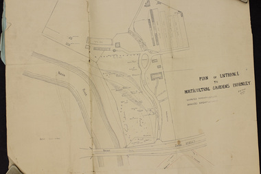
Plan, Plan of Entrance to Horticultural Gardens Burnley, 1932
... . Trees on East side named. (2) Memorandum to The Agricultural... on East side named. (2) Memorandum to The Agricultural ...Copy of plan photographed at the Public Records Office Victoria. (1) Hand drawn plan signed by A.W. Jessep 8/12/32 with 'Suspected Roadway' and ' Suggested Roadway'. Scale 1 inch - 1 chain. Trees on East side named. (2) Memorandum to The Agricultural Superintendent dated 08.12.1932 'Re Proposed Boulevard Along the River Yarra' from the Principal A.W. Jessep. Plan had been to put road through the Lagoon Paddock and he suggested the route outside the Burnley College grounds.prov, burnley gardens, a.w. jessep -
 Orbost & District Historical Society
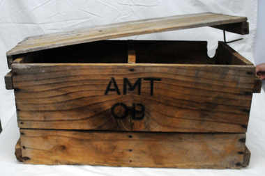
box, first half 20th century
... on the east side of the river, in order to save on the costs... on the east side of the river, in order to save on the costs ...This box was used by Lindsay Thomson's mother, Annie M. Thomson for the transport of hen eggs from Orbost to Melbourne by rail - C 1940's -1950's. The Bairnsdale-Orbost railway was opened in 1916 to serve the agricultural and timber industry. Because of the decline in traffic and heavy operating costs, the line was finally closed in August, 1987. Orbost Railway Station was opened on Monday 10 April 1916 as the terminus of the Orbost railway line, and closed in 1987. The station was located on the west side of the Snowy River despite the town of Orbost being on the east side of the river, in order to save on the costs of a bridge over the river, which at the time had highly variable levels. This item is associated with the history of the Orbost-Bairnsdale railway line and therefore reflects the role that the rail line played in the social and economic history of Orbost. A wooden box with two inside sections and a wooden lid which is secured on both ends by large nails/spikes which are fitted into a groove and are then turned. On front and back in black stencilled letters A M T O B container railway eggs -
 Ballarat Tramway Museum
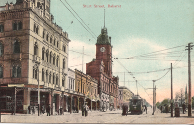
Postcard, JE, "Sturt Street Ballarat", 1909
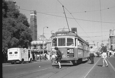
... from the east side of the intersection, looking towards... pedestrians in the picture. Taken from the east side ...Coloured postcard of an ESCo tram westbound at the intersection of Sturt and Lydiard St. Ballarat, c1906 - 7 - has a destination box. There are several pedestrians in the picture. Taken from the east side of the intersection, looking towards the Town Hall, with the National Mutual Insurance building and Snows in the photo. Also shows the overhead arrangements - two wire for Sturt St, single for Lydiard St, coming into the intersection. On the rear of the postcard are the initials "JE" in the top centre, a 1d Victorian stamp, cancelled 5/4/1909, addressed to a Mrs Sproston of Skeleton Cottage Avoca with a message from her granddaughters - Fervie and Edith. See item 3279 for a black-and-white version. Yields information about Sturt St at Lydiard St looking west and the tramway overhead.Printed colour postcard titled Postcard - "Sturt Street Ballarat" used - 1909See image i2 for letter and posting details.trams, tramways, esco, sturt st, postcards, overhead, town hall -
 Melton City Libraries
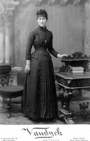
Photograph, Elizabeth (Lizzie) Daley, 1907, Unknown
... the cottage after Lizzie death. Max Myers built a house on the east... Lizzie death. Max Myers built a house on the east side ...Elizabeth (Lizzie) Daley, born c.1865, died 8 Aug 1949. Daughter of William and Eliza, Melton, sister of Ann. The Daley family's cottage was on High St north nearest to Alexander St. The photo of William Daley was taken in front of his Bootmaker Shop. The shop remained in the family later being run as a Haberdashery shop by Lizzie his second daughter John Lugg rented the cottage after Lizzie death. Max Myers built a house on the east side of the cottage in 1952. The cottage was demolished and the weatherboard house was eventually moved to another location when the street became a shopping area 1970’s. The Condon family lived beside Lizzie’s ShopPhotographs of Elizabeth Daley taken different periods of her lifelocal identities, pioneer families -
 Orbost & District Historical Society
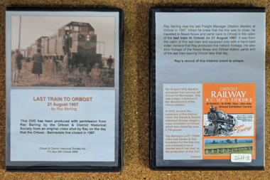
D.V.D. s, Last Train to Orbost, 21.8.1987
... the town of Orbost being on the east side of the river, in order... the town of Orbost being on the east side of the river, in order ...These are copies of an original video shot by Ray Barling on the day that the Orbost-Bairnsdale line closed in 1987. He used a hand-held video camera from his cabin on the train, The video was shown at the 2016 Centenary Exhibition in Orbost. The Bairnsdale-Orbost railway was opened in 1916 to serve the agricultural and timber industry. Because of the decline in traffic and heavy operating costs, the line was finally closed in August, 1987. Orbost Railway Station was opened on Monday 10 April 1916 as the terminus of the Orbost railway line, and closed in 1987. The station was located on the west side of the Snowy River despite the town of Orbost being on the east side of the river, in order to save on the costs of a bridge over the river, which at the time had highly variable levels. This item is associated with the history of the Orbost-Bairnsdale railway line and therefore reflects the role that the rail line played in the social and economic history of Orbost. On April 10 1916, the first scheduled train service left Orbost for Bairnsdale. The Bairnsdale-Orbost railway was opened to serve the agricultural and timber industry. Because of the decline in traffic and heavy operating costs, the line was finally closed in August, 1987. Orbost Railway Station was opened on Monday 10 April 1916 as the terminus of the Orbost railway line, and closed in 1987. The station was located on the west side of the Snowy River despite the town of Orbost being on the east side of the river, in order to save on the costs of a bridge over the river, which at the time had highly variable levels, The video was shown for the first time at the Centenary Exhibition held in Orbost, by the Orbost & District Historical Society, t created much interest leading to the production of the videos.Two copies of a D.V.D. titled"Last Train To Orbost 21 August 1987". The cover is a photo of the last train.rail-closure orbost-bairnsdale-railway -
 Federation University Historical Collection
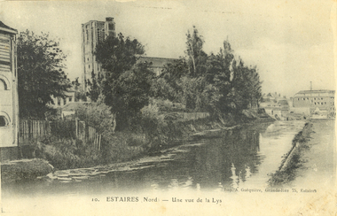
Postcard - black and white, Estaires, France, c1917, C1917
... and Extension is on the eastern outskirts of the town and on the east... is on the eastern outskirts of the town and on the east side of the road ...WW1 Australian soldier Holmes Famiiy memento. Estaires is a town and commune in the Department of the Nord, about 11 kilometres west of Armentieres. The Estaires Communal Cemetery and Extension is on the eastern outskirts of the town and on the east side of the road to Bailleul. Estaires town was occupied by French cavalry on the 15 October 1914, and passed at once into British hands. On the 10 April 1918 it was captured by the enemy, after an obstinate defence by the 50th (Northumbrian) Division; and it was finally retaken by British troops at the beginning of September 1918. The town was a Field Ambulance centre as early as November 1914, and later the 1st Australian Casualty Clearing Station was posted in it. (http://www.cwgc.org/find-a-cemetery/cemetery/26801/ESTAIRES%20COMMUNAL%20CEMETERY%20AND%20EXTENSION, accessed 11/07/2014)Australian soldier's WW1souvenirA black and white postcard with buildings along a river at Estaires in Northern France.estaires communal cemetery and extension, estaires, france, chatham-holmes family collection, 1st australian casualty clearing station, postcard -
 Ballarat Tramway Museum
Negative - Set of 4, Campbell Duncan, 2/07/1971 12:00:00 AM
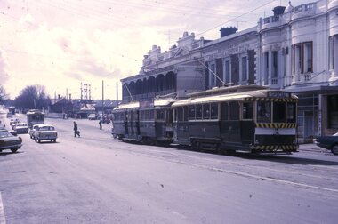
... station with No. 40 waiting. Has buildings on the east side... buildings on the east side of the street, including JJ Coller & Co ...Set of 4 photographs taken on 28/2/1971 by Campbell Duncan of trams on the Lydiard St North line between Sturt St and the Railway Station. .1 - No. 40 just after entering Lydiard St Nth, with Craigs Hotel, National Mutual Building and the ANZ bank in the background. .2 No. 36 entering the double track near the railway station with No. 40 waiting. Has buildings on the east side of the street, including JJ Coller & Co and Reid's Coffee Palace in the background. .3 - ditto .4 - Nos 36 and 40 crossing on the double track in Lydiard St North,trams, tramways, lydiard st north, tram 36 tram 40 -
 Ballarat Tramway Museum
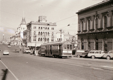
Photograph - Colour Photograph/s, 23/11/1962 12:00:00 AM
... are various buildings along the east side of Pall Mall and along.... In the background are various buildings along the east side of Pall Mall ...Colour postcard size print of SEC Bendigo trams 26 and a single trucker at Charing Cross with Mitchell St. in the background. Photo dated 21.11.1962. Printed on AGFA paper. Both trams fitted with dash canopy lighting, but no large white strip under the driver's windows. 26 showing destination of "Eaglehawk" with two SEC ads and another ad on the front dash panel. Single trucker has a Castrol ad on the roof. In the background are various buildings along the east side of Pall Mall and along Mitchell St. Pole by the front of 26 has directional signs "Melbourne" and "Heathcote / Echuca". On rear top left hand corner "21.11.62" in very wavy handwriting typical of an aged person.bendigo, pall mall, charing cross, tram 26 -
 Ballarat Tramway Museum
Slide - 35mm slide/s - set of 3, Peter Moses, Jan. 1969
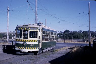
... in the distance and other buildings on the east side of the street... the Shamrock Hotel in the distance and other buildings on the east side ...Set of two colour slides taken at the North Bendigo terminus and another in Pall Mall, Bendigo, Jan. 1969. .1 - No. 30 at North Bendigo terminus - has destination "Golden Square" .2 - Interior view of Birney tram with crew members numbers 22, 29 and three seated passengers. .3 - View of Pall Mall looking north from the tram stop - has the Shamrock Hotel in the distance and other buildings on the east side of the street, including a 3BO (Bendigo radio) sign. Kodak cardboard mount slide, taken by Peter Moses, Jan. 1969.On the rear of all the slides "P. Moses" in black ink .1 -"Bendigo / North Bendigo terminus" in blue ink, and in red ink “12” .2 - " Jan 1969 Bendigo / Inside Brill car" in blue ink .3 - "Bendigo Pall Mall" in black ink and in red ink “7”.tramways, trams, bendigo, north bendigo, birney, tram crews, pall mall, tram 30 -
 Kew Historical Society Inc
Plan - Subdivision Plan, Myrtle Park Estate, Emerald, 1915
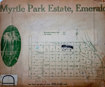
... allotments 8-12 on the east side of the Estate. The photograph... through allotments 8-12 on the east side of the Estate ...This subdivision plan for the ‘Myrtle Park Estate’ relates to land sales in Emerald, Victoria, rather than to the subdivision of the same name in East Kew (1913-16). The subdivision in Emerald included 32 one-acre lots facing Torley Road, Government Road (now Rawhiti and Wong Hee Roads) Beaconsfield Road (now Old Beaconsfield Road). On the plan, an unnamed creek flows through allotments 8-12 on the east side of the Estate. The photograph of a waterfall and the advertised price of Day Return and Weekend Return Fares provide an indication of who the prospective purchasers were likely to be.subdivision plans - emerald, myrtle park estate, torley road -- emerald (vic.) -
 Kew Historical Society Inc
Plan - Subdivision Plan, J Hurrey, Section 115 in the Parish of Boroondara Near Richmond Bridge, 1853
... named streets, the section was located on the east side of Burke... named streets, the section was located on the east side of Burke ...Despite the plans claims that it is a subdivision near the Richmond Bridge, Section 115 was located at what is now Camberwell Junction. While the plan only lists government roads rather than named streets, the section was located on the east side of Burke Road, stretching up the hill from the current Junction. Research on Trove, conducted by Kerry Fairbank, discovered an advertisement for unsold lots in Section 115 which clarifies the extent and location of subsequent land sales in the original section. The original article can be viewed through the link in the catalogue record. The interesting link to Kew is the reference to James Beavan as the purchaser of lots 14 and 15. The historian Gwen McWilliam has notes that a Mr Beavan changed his name from Bevan. The Bevans were descendants of the Derricks family of Kew. This subdivision plan is the earliest original map or plan in the collection which shows parts of what is now the City of Boroondara, dating from circa 1853. It provides important information for researchers on subsequent subdivisions following the original land sales in [Camberwell] Boroondara. The site, on the east side of Burke Road is a highly-significant and historic site. This is believed to be the only extant copy of the subdivision in public collections.A small plan on parchment listing 28 lots, between one and two acres each, for sale in Section 115 in the Parish of Boroondara, dating from 1853 when the portion was subdivided.Obverse: Lot 16 "Joseph Duval", Lots 14 & 15 "James Beavan". Other annotations (measurements) are unreadable. Reverse: "KH-981 / Section 115 in the Parish of Boroondara / Near Richmond Bridge / 1640T. / J Duval / 14-15 J. Beavanparish of boroondara, subdivision plans - camberwell, section 115 - boroondara, subdivision plans -- camberwell (vic), riverscape road, burke road, camberwell junction -
 Kew Historical Society Inc
Slide - 'Reno', St John 's Parade, 1977
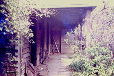
... ‘Reno’, stood on the east side of St John’s Parade. Its... ‘Reno’, stood on the east side of St John’s Parade. Its earliest ...‘Reno’, stood on the east side of St John’s Parade. Its earliest recorded owner was the architect Samuel Cocking who lived there from c.1865 until his death in 1888. The original landholding was bordered by Cotham Road, Glenferrie Road, Wellington Street, and Charles Street. The southern portion of this land included a fine orchard, with many imported trees. The old summer house, at first in the orchard, was later removed to the house garden. The MMBW Detail Plan No.1576 (1904) shows the remaining portion of the original land holding, including a semi-circular pathway at the front, and garden features such as an aviary, a fountain and grotto, and a fernery. The garden including rare plants supplied by Baron Von Mueller, surrounds the cottage in a tangled frenzy. Despite a ‘local significance’ classification by the National Trust, the house was demolished in 1977.Rare photograph of an historically important weatherboard cottage in St John's Parade.Colour positive transparency (slide) of the verandah of 'Reno' in St John's Parade, Kew (demolished 1977). historic houses -- kew (vic.), reno -- st john's parade -- kew (vic.) -
 Kew Historical Society Inc
Slide - 'Reno', St John 's Parade, 1977
... ‘Reno’, stood on the east side of St John’s Parade. Its... ‘Reno’, stood on the east side of St John’s Parade. Its earliest ...‘Reno’, stood on the east side of St John’s Parade. Its earliest recorded owner was the architect Samuel Cocking who lived there from c.1865 until his death in 1888. The original landholding was bordered by Cotham Road, Glenferrie Road, Wellington Street, and Charles Street. The southern portion of this land included a fine orchard, with many imported trees. The old summer house, at first in the orchard, was later removed to the house garden. The MMBW Detail Plan No.1576 (1904) shows the remaining portion of the original land holding, including a semi-circular pathway at the front, and garden features such as an aviary, a fountain and grotto, and a fernery. The garden including rare plants supplied by Baron Von Mueller, surrounds the cottage in a tangled frenzy. Despite a ‘local significance’ classification by the National Trust, the house was demolished in 1977.Rare photograph of an historically important weatherboard cottage in St John's Parade.Colour positive transparency (slide) of the a doorway of 'Reno' in St John's Parade, Kew (demolished 1977). historic houses -- kew (vic.), reno -- st john's parade -- kew (vic.) -
 Kew Historical Society Inc
Slide - 'Reno', St John 's Parade, 1977
... ‘Reno’, stood on the east side of St John’s Parade. Its... ‘Reno’, stood on the east side of St John’s Parade. Its earliest ...‘Reno’, stood on the east side of St John’s Parade. Its earliest recorded owner was the architect Samuel Cocking who lived there from c.1865 until his death in 1888. The original landholding was bordered by Cotham Road, Glenferrie Road, Wellington Street, and Charles Street. The southern portion of this land included a fine orchard, with many imported trees. The old summer house, at first in the orchard, was later removed to the house garden. The MMBW Detail Plan No.1576 (1904) shows the remaining portion of the original land holding, including a semi-circular pathway at the front, and garden features such as an aviary, a fountain and grotto, and a fernery. The garden including rare plants supplied by Baron Von Mueller, surrounds the cottage in a tangled frenzy. Despite a ‘local significance’ classification by the National Trust, the house was demolished in 1977.Rare photograph of an historically important weatherboard cottage in St John's Parade.Colour positive transparency (slide) of the verandah of 'Reno' in St John's Parade, Kew (demolished 1977). historic houses -- kew (vic.), reno -- st john's parade -- kew (vic.) -
 Kew Historical Society Inc
Slide - Grotto of 'Reno', St John 's Parade, 1977
... ‘Reno’, stood on the east side of St John’s Parade. Its... ‘Reno’, stood on the east side of St John’s Parade. Its earliest ...‘Reno’, stood on the east side of St John’s Parade. Its earliest recorded owner was the architect Samuel Cocking who lived there from c.1865 until his death in 1888. The original landholding was bordered by Cotham Road, Glenferrie Road, Wellington Street, and Charles Street. The southern portion of this land included a fine orchard, with many imported trees. The old summer house, at first in the orchard, was later removed to the house garden. The MMBW Detail Plan No.1576 (1904) shows the remaining portion of the original land holding, including a semi-circular pathway at the front, and garden features such as an aviary, a fountain and grotto, and a fernery. The garden including rare plants supplied by Baron Von Mueller, surrounds the cottage in a tangled frenzy. Despite a ‘local significance’ classification by the National Trust, the house was demolished in 1977.Rare photograph of an historically important weatherboard cottage in St John's Parade.Colour positive transparency (slide) of the grotto in the garden of 'Reno' in St John's Parade, Kew (demolished 1977). historic houses -- kew (vic.), reno -- st john's parade -- kew (vic.) -
 Kew Historical Society Inc
Slide - Former Summerhouse in the Garden of 'Reno', St John 's Parade, 1977
... ‘Reno’, stood on the east side of St John’s Parade. Its... ‘Reno’, stood on the east side of St John’s Parade. Its earliest ...‘Reno’, stood on the east side of St John’s Parade. Its earliest recorded owner was the architect Samuel Cocking who lived there from c.1865 until his death in 1888. The original landholding was bordered by Cotham Road, Glenferrie Road, Wellington Street, and Charles Street. The southern portion of this land included a fine orchard, with many imported trees. The old summer house, at first in the orchard, was later removed to the house garden. The MMBW Detail Plan No.1576 (1904) shows the remaining portion of the original land holding, including a semi-circular pathway at the front, and garden features such as an aviary, a fountain and grotto, and a fernery. The garden including rare plants supplied by Baron Von Mueller, surrounds the cottage in a tangled frenzy. Despite a ‘local significance’ classification by the National Trust, the house was demolished in 1977.Rare photograph of an historically important weatherboard cottage in St John's Parade.Colour positive transparency (slide) of the former summerhouse in the garden of 'Reno' in St John's Parade, Kew (demolished 1977). historic houses -- kew (vic.), reno -- st john's parade -- kew (vic.) -
 Kew Historical Society Inc
Slide - 'Reno', St John 's Parade, 1977
... ‘Reno’, stood on the east side of St John’s Parade. Its... ‘Reno’, stood on the east side of St John’s Parade. Its earliest ...‘Reno’, stood on the east side of St John’s Parade. Its earliest recorded owner was the architect Samuel Cocking who lived there from c.1865 until his death in 1888. The original landholding was bordered by Cotham Road, Glenferrie Road, Wellington Street, and Charles Street. The southern portion of this land included a fine orchard, with many imported trees. The old summer house, at first in the orchard, was later removed to the house garden. The MMBW Detail Plan No.1576 (1904) shows the remaining portion of the original land holding, including a semi-circular pathway at the front, and garden features such as an aviary, a fountain and grotto, and a fernery. The garden including rare plants supplied by Baron Von Mueller, surrounds the cottage in a tangled frenzy. Despite a ‘local significance’ classification by the National Trust, the house was demolished in 1977.Rare photograph of an historically important weatherboard cottage in St John's Parade.Colour positive transparency (slide) of the garden of 'Reno' in St John's Parade, Kew (demolished 1977). historic houses -- kew (vic.), reno -- st john's parade -- kew (vic.) -
 Kew Historical Society Inc
Slide - Former Summerhouse in the Garden of 'Reno', St John 's Parade, 1977
... ‘Reno’, stood on the east side of St John’s Parade. Its... ‘Reno’, stood on the east side of St John’s Parade. Its earliest ...‘Reno’, stood on the east side of St John’s Parade. Its earliest recorded owner was the architect Samuel Cocking who lived there from c.1865 until his death in 1888. The original landholding was bordered by Cotham Road, Glenferrie Road, Wellington Street, and Charles Street. The southern portion of this land included a fine orchard, with many imported trees. The old summer house, at first in the orchard, was later removed to the house garden. The MMBW Detail Plan No.1576 (1904) shows the remaining portion of the original land holding, including a semi-circular pathway at the front, and garden features such as an aviary, a fountain and grotto, and a fernery. The garden including rare plants supplied by Baron Von Mueller, surrounds the cottage in a tangled frenzy. Despite a ‘local significance’ classification by the National Trust, the house was demolished in 1977.Rare photograph of an historically important weatherboard cottage in St John's Parade.Colour positive transparency (slide) of the former summerhouse in the garden of 'Reno' in St John's Parade, Kew (demolished 1977). historic houses -- kew (vic.), reno -- st john's parade -- kew (vic.) -
 Kew Historical Society Inc
Photograph - 'Reno', 10 St John's Parade, John T Collins, 1977
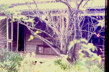
... ‘Reno’, stood on the east side of St John’s Parade. Its... ‘Reno’, stood on the east side of St John’s Parade. Its earliest ...‘Reno’, stood on the east side of St John’s Parade. Its earliest recorded owner was the architect Samuel Cocking who lived there from c.1865 until his death in 1888. The original landholding was bordered by Cotham Road, Glenferrie Road, Wellington Street, and Charles Street. The southern portion of this land included a fine orchard, with many imported trees. The old summer house, at first in the orchard, was later removed to the house garden. The MMBW Detail Plan No.1576 (1904) shows the remaining portion of the original land holding, including a semi-circular pathway at the front, and garden features such as an aviary, a fountain and grotto, and a fernery. The garden including rare plants supplied by Baron Von Mueller, surrounds the cottage in a tangled frenzy. Despite a ‘local significance’ classification by the National Trust, the house was demolished in 1977.Partial view, north side of the weatherboard cottage in St John's Parade, Kew, known as 'Reno' (demolished 1977). Architectural elements revealed in this photo by John T Collins include: two wing, hip roof construction; external buildings at angles to main wing; corrugated iron roofing [over shingles]; brick chimney external to building; unvarnished/unpainted external weatherboards. General dilapidated condition. "Kew 'Reno' 10 St Johns Pde / John Collins, 11 Anderson Road, Hawthorn East, 3123, Film 35B Exposure 27"reno - st john's parade -- kew (vic.), john t collins -
 Kew Historical Society Inc
Photograph - 'Reno', 10 St John's Parade, John T Collins, 1977
... ‘Reno’, stood on the east side of St John’s Parade. Its... ‘Reno’, stood on the east side of St John’s Parade. Its earliest ...‘Reno’, stood on the east side of St John’s Parade. Its earliest recorded owner was the architect Samuel Cocking who lived there from c.1865 until his death in 1888. The original landholding was bordered by Cotham Road, Glenferrie Road, Wellington Street, and Charles Street. The southern portion of this land included a fine orchard, with many imported trees. The old summer house, at first in the orchard, was later removed to the house garden. The MMBW Detail Plan No.1576 (1904) shows the remaining portion of the original land holding, including a semi-circular pathway at the front, and garden features such as an aviary, a fountain and grotto, and a fernery. The garden including rare plants supplied by Baron Von Mueller, surrounds the cottage in a tangled frenzy. Despite a ‘local significance’ classification by the National Trust, the house was demolished in 1977.Partial view, side of the weatherboard cottage in St John's Parade, Kew, known as 'Reno' (demolished 1977). Architectural elements revealed in this photo by John T Collins include: hip roof construction; corrugated iron roofing [over shingles]; unvarnished/unpainted external weatherboards; Externally opening 1860s-style casement window. General dilapidated condition. "Kew 'Reno' 10 St Johns Pde / John Collins, 11 Anderson Road, Hawthorn East, 3123, Film 35B Exposure 26"reno - st john's parade -- kew (vic.), john t collins -
 Kew Historical Society Inc
Photograph - 'Reno', 10 St John's Parade, John T Collins, 1977
... ‘Reno’, stood on the east side of St John’s Parade. Its... ‘Reno’, stood on the east side of St John’s Parade. Its earliest ...‘Reno’, stood on the east side of St John’s Parade. Its earliest recorded owner was the architect Samuel Cocking who lived there from c.1865 until his death in 1888. The original landholding was bordered by Cotham Road, Glenferrie Road, Wellington Street, and Charles Street. The southern portion of this land included a fine orchard, with many imported trees. The old summer house, at first in the orchard, was later removed to the house garden. The MMBW Detail Plan No.1576 (1904) shows the remaining portion of the original land holding, including a semi-circular pathway at the front, and garden features such as an aviary, a fountain and grotto, and a fernery. The garden including rare plants supplied by Baron Von Mueller, surrounds the cottage in a tangled frenzy. Despite a ‘local significance’ classification by the National Trust, the house was demolished in 1977.Side of the original, relocated summer house of 'Reno' at 10 St John's Parade, Kew, (demolished 1977). Architectural elements revealed in this photo by John T Collins include: four-sided construction; trellis and weatherboard walls; corrugated iron roofing. Re-use as woodshed. General dilapidated condition. "Kew 'Reno' 10 St Johns Pde / John Collins, 11 Anderson Road, Hawthorn East, 3123, Film 35B Exposure 24"reno - st john's parade -- kew (vic.), john t collins -
 Linton and District Historical Society Inc
Photograph, Carrie Murrell outside Murrell's Newsagency, Linton
... of Sussex Street to the east side, into a shop next to the Railway... of Sussex Street to the east side, into a shop next to the Railway ...Carrie Rogers Murrell, b.1905 at Daylesford, was a daughter of William Murrell and his wife Lily, née Clarke/Young. She was a grand-daughter of Ambrose and Mary Murrell. Carrie Murrell attended Linton State School, completing Grade 8 in 1n 1918. She then assisted her father in the Linton newsagency, before taking over as its manager, a role she enjoyed for some seventy years. In 1932 she moved the business from its site on the west side of Sussex Street to the east side, into a shop next to the Railway Hotel that had previously been run as a shoe shop by Dan Cornish. This shop remained as the Linton Newsagency until Carrie retired. It is now used as a private residence. Carrie Murrell died in 1998.Colour photo of Murrell's Newsagency, Miss Murrell seated in front doorway.carrie murrell, linton newsagency -
 Creswick Museum
Photograph, Herman Moser, 1867
... on East side and provided with seats for ladies; entrance 1... roped off on East side and provided with seats for ladies ...Photograph, Sepia, Easter Sports 22 and 23rd April 1867 in aid of Creswick Hospital. Structures in order from gate 1 No. 3 Publican’s Booth- W. Davies. 2 Richardson’s Show 50’ x 25’ inside platform 14’ outside 21’ x 18’ (Braganzro (?) provide poles) 3 Refreshment Booth 50’ x 12 ½ ‘ shingle roof, bazaar and wheel of fortune (J. Hook) 4 No. 1 Publican Booth, T. W. Anthony 40’ x 20'. 5 Storage for donations. Secretary’s office, Steward’s room 60’ x 13’. 6 Dancing Booth 80’ x 30’ floored with such boards; contains 8,000’ of ?? 7 No. 2 Publican’s Booth W. J. Whatman. Sports commenced 1 p.m. 2 large swings at south end of ground; running was 300 yards round platform for dancing in center; skittle alley fenced off near entrance; portion roped off on East side and provided with seats for ladies; entrance 1/- children 6d A. M. Wilson- Aunt Sally; Mr. Rowell- Doodlem Buck ; 3 shils a penny; Bobbly Down; Wheel of Fortune; Sunny’s ? ; skittles, Dancing excellent string band Monster balloon ascends last day, sent by J. Moore at conclusion of sport. Full brass band. Easter Sports Committee; H. Piening treasurer; C. Whiffle; E. Williams; J. Machiman; H. Williams; G. Frazer; B. Trevan; W. Johnson. W. Pobjoy Hon. Sec. Refreshement Booth; Mesdames Geljon, H. Williams, Moore, Sedon (2), Burke, Grigan, Whalley.Lennon Troupe: Lennon, Burrel, & Carroll Taming a Tiger. Photograph taken from Water street about intersection with East side of Roger street. Photo taken by H. Moser Monday 22nd April 1867) Easter Sports 22 and 23rd April 1867 in aid of Creswick Hospital. Photograph, Sepia, 1 No. 3 Publican’s Booth- W. Davies. 2 Richardson’s Show 50’ x 25’ inside platform 14’ outside 21’ x 18’ (Braganzro (?) provide poles) 3 Refreshment Booth 50’ x 12 ½ ‘ shingle roof, bazaar and wheel of fortune (J. Hook) 4 No. 1 Publican Booth, T. W. Anthony 40’ x 20'. 5 Storage for donations. Secretary’s office, Steward’s room 60’ x 13’. 6 Dancing Booth 80’ x 30’ floored with such boards; contains 8,000’ of ?? 7 No. 2 Publican’s Booth W. J. Whatman.photograph, h. moser, easter sports, creswick -
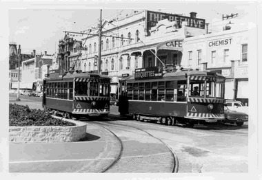 Ballarat Tramway Museum
Photograph - Black & White Photograph/s, Keith Kings, 24/09/1961 12:00:00 AM
... buildings on the east side of Pall Mall. Keith Kings No. L(n)(17... in the background and other buildings on the east side of Pall Mall ...Black and White photograph contained with Reg. Item 1902 - Photo Album from Keith Kings to Les Denmead 1970. Photograph of SEC Bendigo trams 28 and 29 at Charing Cross. Date of photo 24/9/1961. Both trams have the tiger stripes and dash canopy lighting added, but not the large white stripe above the headlight. Both trams have "Nothing Beats Briquettes for Heat" roof advertisements. The Beehive building in the background and other buildings on the east side of Pall Mall. Keith Kings No. L(n)(17) Scanning: i - image file, p - presentation file, b - back of photograph.Stamp in top left hand corner and handwritten number with "K.S. Kings No. L(n)(17) Copyright reserved". In blue ink "Bendigo / Nos. 28 and 29. / Birney Safety Cars. / Charing Cross 24/9/61"trams, tramways, bendigo, beehive building, charing cross, tram 28, tram 29 -
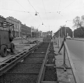 Ballarat Tramway Museum
Negative, Geoff Grant, 19/06/1955 12:00:00 AM
... . Buildings along the east side of Nicholson St. in background, cable.... Buildings along the east side of Nicholson St. in background, cable ...Negative No. N326 and black and white print made by a laser printer (stored in folder ) of view looking along the new track in Nicholson St. Fitzroy, with W6 988 in background by the Exhibition Crossover. Photo shows nature of track construction at this portion of the future East Brunswick, Blyth St. line, an air compressor and the wood/metal barriers to protect roadworks in use at the time. Buildings along the east side of Nicholson St. in background, cable winding house at Gertrude St. can just be seen. Date of photo 19/6/1955. Negative scanned hi res and imaged updated 21/5/2020.trams, tramways, melbourne, nicholson st., east brunswick, track construction., tram w6 988 -
 Melbourne Tram Museum
Photograph - Digital Image, changing the points for the cross over in Latrobe St, late 1960's or 1970
... for the cross over in Latrobe St on the east side of Swanston St... on the east side of Swanston St. The tram has terminated, for a Parade ...Digital image of a photograph from the Ron Scholten Collection of a conductress / conductor changing the points for the cross over in Latrobe St on the east side of Swanston St. The tram has terminated, for a Parade, possibly Moomba during the late 1960's or 1970 as the tram not fitted with side marker lights. In the background is the shot tower with a Penfolds Advert, the Argus building and the ? book Depot. A St Johns ambulance first aid van is parked. The tram has an advert for Queens Bridge Motor Holden and Viva cars (Vauxhall originally) and has a destination of Thornbury - Miller St Tram either SW6 855 or 955.trams, tramways, w6 class, latrobe st, crossover, events, swanston st, thornbury, conductors, conductresses, tram 855, tram 955 -
 Tatura Irrigation & Wartime Camps Museum
Photograph, Ken McInnes
... , Hogan Street, north side, east of Ross Street.... in shop, Hogan Street, north side, east of Ross Street. Ken ...Photo of Ken McInnes, former RAAF radar technician, and post war operated a wireless and TV repair service in shop, Hogan Street, north side, east of Ross Street. -
 Ringwood and District Historical Society
Photograph, Foundation stone for Ringwood State School No. 2997, laid by Mrs. J.K. Turnbull on 15th August, 1889
... 1889-1922. Situated in Ringwood Street, East Side sixty yards... - Ringwood State School 1889-1922. Situated in Ringwood Street, East ...Photograph of Foundation stone for Ringwood State School No. 2997 was laid by Mrs. J.K. Turnbull on 15th August, 1889, marking the opening of the school situated in Whitehorse Road at the corner of Ringwood Street (1889-1922). Mrs. Turnbull was the wife of the Ringwood Station Master. The stone was removed after the school closed in 1922 and re-laid in 1962 by the School Committee at this subsequent Greenwood Avenue school site and is pictured here being viewed near the entrance in 1973 by Mr. Ron Pullin, Archivist, Ringwood Historical Research Group".Sign below photograph reads, "Foundation stone of Ringwood State School (late Ringwood St.). Now in grounds of Greenwood Avenue Ringwood State School". Inscription on stone, "This foundation stone was laid by Mrs. J.K. Turnbull on 15th August 1889". Printed on plaque below stone, "No.2997 - Ringwood State School 1889-1922. Situated in Ringwood Street, East Side sixty yards north of Maroondah Highway. Foundation stone removed 19?? re-erected by the School Committee 1962". -
 Ballarat Tramway Museum
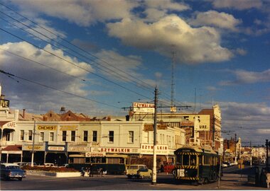
Slide - 35mm slide/s, Travis Jeffrey, late 1960's
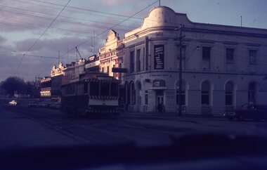
... and other buildings on the east side of Lydiard St. North... on the east side of Lydiard St. North and the rail level crossing ...Agfa plastic mount (blue base, white cover) of a photograph of No. 33 southbound in Lydiard St Nth crossing Mair St. Photo taken late 1960's. Has Howard Smith building in the background and other buildings on the east side of Lydiard St. North and the rail level crossing gates. Photo taken from a motor car, just after sunset. Tramcar has Eureka Roofing tiles and Everything's under control in my all electric kitchen roof advertisement. Slide rescanned at 3200 dpi 25-10-2020, jpg replaced, tiff file retained. This file was scanned in 2003 and may show colour changes."BAS 47" in penciltramways, trams, mair st, lydiard st nth, tram 33 -
 Ballarat Tramway Museum
Slide - 35mm slide/s, Peter Moses, 21/08/1971 12:00:00 AM
... buildings on the east side of Lydiard St. North. Two other single... buildings on the east side of Lydiard St. North. Two other single ...Photo of SEC Ballarat No. 14 and possibly No. 42 (Briquette roof advertisement and features on the same special trams in Reg. item 2064) waiting in Lydiard St. North for the arrival of the ARHS special on Saturday 21/8/1971 to undertake the last tour of Ballarat Tramways, prior to the closure of the system. The first line closure (Victoria St.) took place the following day. Has Reid's Coffee Palace building in the background and other buildings on the east side of Lydiard St. North. Two other single truck cars in the photo as are the railway gates at the station. Kodak cardboard mount slide, taken by Peter Moses 21 August 1971.On back of slide in light black ink "N14 Ballarat / ARHS / 4 trams special Lydiard St" and "P. Moses" in black ink in the upper right hand side of the slide.tramways, trams, arhs, lydiard st north, railway crossing, tram 14, tram 42