Showing 542 items
matching landmark
-
 Kew Historical Society Inc
Plan, Melbourne & Metropolitan Board of Works : Borough of Kew : Detail Plan No.1573, 1905
The Melbourne and Metropolitan Board of Works (MMBW) plans were produced from the 1890s to the 1950s. They were crucial to the design and development of Melbourne's sewerage and drainage system. The plans, at a scale of 40 feet to 1 inch (1:480), provide a detailed historical record of Melbourne streetscapes and environmental features. Each plan covers one or two street blocks (roughly six streets), showing details of buildings, including garden layouts and ownership boundaries, and features such as laneways, drains, bridges, parks, municipal boundaries and other prominent landmarks as they existed at the time each plan was produced. (Source: State Library of Victoria)This plan forms part of a large group of MMBW plans and maps that was donated to the Society by the Mr Poulter, City Engineer of the City of Kew in 1989. Within this collection, thirty-five hand-coloured plans, backed with linen, are of statewide significance as they include annotations that provide details of construction materials used in buildings in the first decade of the 20th century as well as additional information about land ownership and usage. The copies in the Public Record Office Victoria and the State Library of Victoria are monochrome versions which do not denote building materials so that the maps in this collection are invaluable and unique tools for researchers and heritage consultants. A number of the plans are not held in the collection of the State Library of Victoria so they have the additional attribute of rarity.Original survey plan, issued by the MMBW to a contractor with responsibility for constructing sewers in the area identified on the plan within the Borough of Kew. The plan was at some stage hand-coloured, possibly by the contractor, but more likely by officers working in the Engineering Department of the Borough and later Town, then City of Kew. The hand-coloured sections of buildings on the plan were used to denote masonry or brick constructions (pink), weatherboard constructions (yellow), and public buildings (grey). This plan has detailed annotations written in red or blue ink, showing prices, which may be the annual valuations of the properties, and some owners’ names, a most unusual feature on contractor's maps. Some areas, such as the buildings of Methodist Ladies’ College (MLC), include the school’s tennis court and swimming pool, but are not coloured to show building materials – did the draftsman just run out of time, or ink, or enthusiasm, before his plan had to be submitted? MLC had been founded in 1882 as a ‘modern school of the first order’ with buildings that formed ‘a collegiate institution for girls unsurpassed in the colonies’. The goal of its founders was to provide a high-class Christian education for girls, comparable with that provided elsewhere for boys. Some shops are shown along Edgevale Road, though they are not designated as commercial premises. Larger houses are depicted, including ‘Fairlawn’ in Barkers Road, and ‘Clevedon’ and ‘Rosehill’ (now demolished) in Fitzwilliam Street.melbourne and metropolitan board of works, detail plans, mmbw 1573, maps - borough of kew, cartography -
 Kew Historical Society Inc
Plan, Melbourne & Metropolitan Board of Works : Borough of Kew : Detail Plan No.1574, 1905
The Melbourne and Metropolitan Board of Works (MMBW) plans were produced from the 1890s to the 1950s. They were crucial to the design and development of Melbourne's sewerage and drainage system. The plans, at a scale of 40 feet to 1 inch (1:480), provide a detailed historical record of Melbourne streetscapes and environmental features. Each plan covers one or two street blocks (roughly six streets), showing details of buildings, including garden layouts and ownership boundaries, and features such as laneways, drains, bridges, parks, municipal boundaries and other prominent landmarks as they existed at the time each plan was produced. (Source: State Library of Victoria)This plan forms part of a large group of MMBW plans and maps that was donated to the Society by the Mr Poulter, City Engineer of the City of Kew in 1989. Within this collection, thirty-five hand-coloured plans, backed with linen, are of statewide significance as they include annotations that provide details of construction materials used in buildings in the first decade of the 20th century as well as additional information about land ownership and usage. The copies in the Public Record Office Victoria and the State Library of Victoria are monochrome versions which do not denote building materials so that the maps in this collection are invaluable and unique tools for researchers and heritage consultants. A number of the plans are not held in the collection of the State Library of Victoria so they have the additional attribute of rarity.Original survey plan, issued by the MMBW to a contractor with responsibility for constructing sewers in the area identified on the plan within the Borough of Kew. The plan was at some stage hand-coloured, possibly by the contractor, but more likely by officers working in the Engineering Department of the Borough and later Town, then City of Kew. The hand-coloured sections of buildings on the plan were used to denote masonry or brick constructions (pink), weatherboard constructions (yellow), and public buildings (grey). This plan shows several very large houses, particularly along Glenferrie Road, and the area now occupied by Ruyton Girls’ School. ‘Tarring’ (incorrectly spelled here as ‘Karring’) was built for Henry Henty in 1872, on part of his original allotment of 20 acres, and ‘Mount View’, which retains its original building and the fountain in the front garden, is part of Ruyton’s Junior School. The most significant change to Tarring and its grounds since 1903, involve the removal of a number of the outbuildings, including a Burmese temple, bought by Henty from the Burmese Exhibit at the Great Exhibition of 1880. It is shown on the plan as a summerhouse. The two-storey mansion, on the corner of Glenferrie Road and Wellington Street, was built in 1891 by leading architect Alfred White as his own home. Having an initial N.A.V. of £160, the house was purchased by a warehouseman Henry Lister, by 1900, when the N.A.V. was recorded at £111. By the turn of the century the house was known as ‘Comaques’. By contrast, much smaller houses are shown in Scott and Byron Streets, including a tiny Mission Hall in Byron Street, which belonged to the Anglican Church from at least 1903 to 1917.melbourne and metropolitan board of works, detail plans, maps - borough of kew, mmbw 1574, cartography -
 Kew Historical Society Inc
Plan, Melbourne & Metropolitan Board of Works : Borough of Kew : Detail Plan No.1575, 1905
The Melbourne and Metropolitan Board of Works (MMBW) plans were produced from the 1890s to the 1950s. They were crucial to the design and development of Melbourne's sewerage and drainage system. The plans, at a scale of 40 feet to 1 inch (1:480), provide a detailed historical record of Melbourne streetscapes and environmental features. Each plan covers one or two street blocks (roughly six streets), showing details of buildings, including garden layouts and ownership boundaries, and features such as laneways, drains, bridges, parks, municipal boundaries and other prominent landmarks as they existed at the time each plan was produced. (Source: State Library of Victoria)This plan forms part of a large group of MMBW plans and maps that was donated to the Society by the Mr Poulter, City Engineer of the City of Kew in 1989. Within this collection, thirty-five hand-coloured plans, backed with linen, are of statewide significance as they include annotations that provide details of construction materials used in buildings in the first decade of the 20th century as well as additional information about land ownership and usage. The copies in the Public Record Office Victoria and the State Library of Victoria are monochrome versions which do not denote building materials so that the maps in this collection are invaluable and unique tools for researchers and heritage consultants. A number of the plans are not held in the collection of the State Library of Victoria so they have the additional attribute of rarity.Original survey plan, issued by the MMBW to a contractor with responsibility for constructing sewers in the area identified on the plan within the Borough of Kew. The plan was at some stage hand-coloured, possibly by the contractor, but more likely by officers working in the Engineering Department of the Borough and later Town, then City of Kew. The hand-coloured sections of buildings on the plan were used to denote masonry or brick constructions (pink), weatherboard constructions (yellow), and public buildings (grey). Plan No.1575 shows that in the area bounded by Wellington Street, Edgevale Road, Glenferrie Road, and Cotham Road, there had already been significant subdivision of land and houses constructed. As one of the highest points in Kew, as expected, there were already some significant mansions built on large allotments of land. Many of these mansions are identified by name on the plan such as ‘Kelso’, ‘Abbotsford’, ‘Clarendon’ and ‘Ashlyn’ in Cotham Road. Other houses of equal size are unnamed on the plan.melbourne and metropolitan board of works, detail plans, maps - borough of kew, mmbw 1575, cartography -
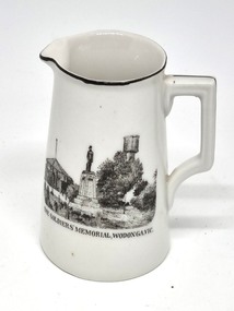 Wodonga & District Historical Society Inc
Souvenir - Souvenir Cream Jug - Soldiers' Memorial, Wodonga
This item is from a collection donated by descendants of John Francis Turner of Wodonga. A wide range of small china pieces carrying scenic views of holiday destinations or key locations were a popular kind of souvenir during much of the 20th century. Several different items have been produced to commemorate Wodonga and its landmarks over time. These items document key changes in Wodonga and its heritage. This plate depicts three key landmarks in Wodonga. THE SOLDIERS' MEMORIAL in Wodonga was unveiled on Tuesday 18th November 1924. It was designed by Messrs. Hosken & Co., of Hawthorn, Victoria. The monument is all of Australian workmanship. The pedestal is made of Harcourt granite, 9ft x 9ft at the base, and rising in seven courses to a height of 10ft 2in. The emblems (rising sun and wreath) are of bronze, and the lettering of the inscription and names of fallen soldiers are in raised lead letters. Originally the Memorial was completed with a full life size, 6ft in height, sculpture of an Australian soldier in Sicilian marble. The memorial bore the inscriptions: ERECTED BY THE RESIDENTS OF WODONGA AND DISTRICT IN MEMORY of the Men of this Town and District who fell in the Great War, 1914-1919, Also in grateful recognition of the men who served and returned. “Lest We Forget.” In 1982, due to frequent vandalism and high cost of materials to repair, the soldier statue was removed and later installed at the RSL Rooms. THE WATER TOWER is a major landmark of High Street, Wodonga. It began operation from January 1924 until it ceased operation in 1959. It stood unused for a decade until the lower section was modified and put to use as “ The Tower’s Cobbler’s Inn” in 1962. In 1972 Wodonga City Council proposed to demolish the Tower. Their suggestion received an unfavorable response from the city’s citizens, so the Tower still stands today. THE BAND ROTUNDA was officially opened on Sunday 5th September 1920 at the naming of the triangular reserve at the corner of High and Hovell Streets as Woodland Grove. The Wodonga Band gave a public performance on this occasion. The tri-coloured ribbon, which stretched across the entrance to the Rotunda was cut by Mrs R.H Murphy, daughter of Mr. John Woodland, secretary of the Wodonga Shire Council for 35 years, after whom the area was named. The rotunda has since been moved to Martin Park, Wodonga.This item comes from a collection used by a prominent citizen of Wodonga. It is also an excellent example of souvenir items created featuring landmarks to represent the city of Wodonga.White glazed porcelain cream jug with grooved square handle. The base is unglazed. The rim and outer face of the handle are outlined in black paint. On one side of the jug is a black transfer print of a the Wodonga Soldiers' Memorial. Text underneath the scene reads "THE SOLDIERS' MEMORIAL, WODONGA, VIC."'. The manufacturer's trademark is printed on the base of the jug. RKG stood for Rudolf Kampf of Grunlas. The mark with the initials under the crown was used from 1921 to 1938.Beneath the image: 'THE SOLDIERS' MEMORIAL WODONGA VIC" Under the jug Manufacturer's trademark printed in orange paint, in a circular formation '(crown) / RK / G' ('RK / G' within circle with handles) above the words "Made in Czechoslovakia"domestic items, souvenir wodonga, woodland grove wodonga -
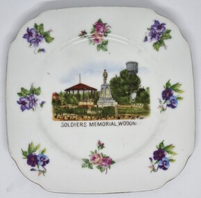 Wodonga & District Historical Society Inc
Souvenir - China Souvenir Plate Soldiers' Memorial. Wodonga, Victoria China, c1924 - 1939
This item is from a collection donated by descendants of John Francis Turner of Wodonga. A wide range of small china pieces carrying scenic views of holiday destinations or key locations were a popular kind of souvenir during much of the 20th century. Several different items have been produced to commemorate Wodonga and its landmarks over time. These items document key changes in Wodonga and its heritage. This plate depicts three key landmarks in Wodonga. THE SOLDIERS' MEMORIAL in Wodonga was unveiled on Tuesday 18th November 1924. It was designed by Messrs. Hosken & Co., of Hawthorn, Victoria. The monument is all of Australian workmanship. The pedestal is made of Harcourt granite, 9ft x 9ft at the base, and rising in seven courses to a height of 10ft 2in. The emblems (rising sun and wreath) are of bronze, and the lettering of the inscription and names of fallen soldiers are in raised lead letters. Originally the Memorial was completed with a full life size, 6ft in height, sculpture of an Australian soldier in Sicilian marble. The memorial bore the inscriptions: ERECTED BY THE RESIDENTS OF WODONGA AND DISTRICT IN MEMORY of the Men of this Town and District who fell in the Great War, 1914-1919, Also in grateful recognition of the men who served and returned. “Lest We Forget.” In 1982, due to frequent vandalism and high cost of materials to repair, the soldier statue was removed and later installed at the RSL Rooms. THE WATER TOWER is a major landmark of High Street, Wodonga. It began operation from January 1924 until it ceased operation in 1959. It stood unused for a decade until the lower section was modified and put to use as “ The Tower’s Cobbler’s Inn” in 1962. In 1972 Wodonga City Council proposed to demolish the Tower. Their suggestion received an unfavorable response from the city’s citizens, so the Tower still stands today. THE BAND ROTUNDA was officially opened on Sunday 5th September 1920 at the naming of the triangular reserve at the corner of High and Hovell Streets as Woodland Grove. The Wodonga Band gave a public performance on this occasion. The tri-coloured ribbon, which stretched across the entrance to the Rotunda was cut by Mrs R.H Murphy, daughter of Mr. John Woodland, secretary of the Wodonga Shire Council for 35 years, after whom the area was named. The rotunda has since been moved to Martin Park, Wodonga.This item comes from a collection used by a prominent citizen of Wodonga. It is also an excellent example of souvenir items created featuring landmarks to represent the city of Wodonga.A china plate depicting the Soldiers' Memorial Wodonga. The central coloured image is surrounded by a 8 representations of a variety of flowers and a silver edge trim. The makers mark underneath the dish was used between 1918 - 1939 so assists in establishing provenance of the irem.Beneath image: "SOLDIERS' MEMORIAL WODONGA On back of dish, Beneath a crown " VICTORIA CHINA CZECHOSLAVAKIA"victoria china, souvenir wodonga, wodonga soldiers memorial, woodland grove wodonga -
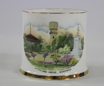 Wodonga & District Historical Society Inc
Memorabilia - China Souvenir Cup Woodland Grove Wodonga, c. 1925 - 1940
A wide range of small china pieces carrying scenic views of holiday destinations or key locations were a popular kind of souvenir during much of the 20th century. Several different items have been produced to commemorate Wodonga and its landmarks over time. These items document key changes in Wodonga and its heritage. This cup depicts three key landmarks in Wodonga. THE SOLDIERS' MEMORIAL in Wodonga was unveiled on Tuesday 18th November 1924. It was designed by Messrs. Hosken & Co., of Hawthorn, Victoria. The monument is all of Australian workmanship. The pedestal is made of Harcourt granite, 9ft x 9ft at the base, and rising in seven courses to a height of 10ft 2in. The emblems (rising sun and wreath) are of bronze, and the lettering of the inscription and names of fallen soldiers are in raised lead letters. Originally the Memorial was completed with a full life size, 6ft in height, sculpture of an Australian soldier in Sicilian marble. The memorial bore the inscriptions: ERECTED BY THE RESIDENTS OF WODONGA AND DISTRICT IN MEMORY of the Men of this Town and District who fell in the Great War, 1914-1919, Also in grateful recognition of the men who served and returned. “Lest We Forget.” In 1982, due to frequent vandalism and high cost of materials to repair, the soldier statue was removed and later installed at the RSL Rooms. THE WATER TOWER is a major landmark of High Street, Wodonga. It began operation from 1924 until it ceased operation in 1959. It stood unused for a decade until the lower section was modified and put to use as “ The Tower’s Cobbler’s Inn” in 1962. In 1972 Wodonga City Council proposed to demolish the Tower. Their suggestion received an unfavorable response from the city’s citizens, so the Tower still stands today. THE BAND ROTUNDA was officially opened on Sunday 5th September 1920 at the naming of the triangular reserve at the corner of High and Hovell Streets as Woodland Grove. The Wodonga Band gave a public performance on this occasion. The tri-coloured ribbon, which stretched across the entrance to the Rotunda was cut by Mrs R.H Murphy, daughter of Mr. John Woodland, secretary of the Wodonga Shire Council for 35 years, after whom the area was named. The rotunda has since been moved to Martin Park, Wodonga. This item has local historic and social significance as it depicts which features of the city the community valued in the past. It has artistic significance as an example of the kinds of souvenirs used widely across Australia to represent communities and the landscape.A white souvenir cup made from china with a water colour image of Woodland Grove, Wodonga which incorporates the Soldier Memorial, Water Tower and the Rotunda."WOODLAND GROVE, WODONGA."souvenirs, wodonga, woodland grove, soldiers memorial, wodonga landmarks -
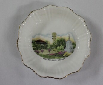 Wodonga & District Historical Society Inc
Memorabilia - China Souvenir Bowl Woodland Grove Wodonga, c. 1920 - 1940
A wide range of small china pieces carrying scenic views of holiday destinations or key locations were a popular kind of souvenir during much of the 20th century. Several different items have been produced to commemorate Wodonga and its landmarks over time. These items document key changes in Wodonga and its heritage. This plate depicts three key landmarks in Wodonga. THE SOLDIERS' MEMORIAL in Wodonga was unveiled on Tuesday 18th November 1924. It was designed by Messrs. Hosken & Co., of Hawthorn, Victoria. The monument is all of Australian workmanship. The pedestal is made of Harcourt granite, 9ft x 9ft at the base, and rising in seven courses to a height of 10ft 2in. The emblems (rising sun and wreath) are of bronze, and the lettering of the inscription and names of fallen soldiers are in raised lead letters. Originally the Memorial was completed with a full life size, 6ft in height, sculpture of an Australian soldier in Sicilian marble. The memorial bore the inscriptions: ERECTED BY THE RESIDENTS OF WODONGA AND DISTRICT IN MEMORY of the Men of this Town and District who fell in the Great War, 1914-1919, Also in grateful recognition of the men who served and returned. “Lest We Forget.” In 1982, due to frequent vandalism and high cost of materials to repair, the soldier statue was removed and later installed at the RSL Rooms. THE WATER TOWER is a major landmark of High Street, Wodonga. It began operation from 1924 until it ceased operation in 1959. It stood unused for a decade until the lower section was modified and put to use as “ The Tower’s Cobbler’s Inn” in 1962. In 1972 Wodonga City Council proposed to demolish the Tower. Their suggestion received an unfavorable response from the city’s citizens, so the Tower still stands today. THE BAND ROTUNDA was officially opened on Sunday 5th September 1920 at the naming of the triangular reserve at the corner of High and Hovell Streets as Woodland Grove. The Wodonga Band gave a public performance on this occasion. The tri-coloured ribbon, which stretched across the entrance to the Rotunda was cut by Mrs R.H Murphy, daughter of Mr. John Woodland, secretary of the Wodonga Shire Council for 35 years, after whom the area was named. The rotunda has since been moved to Martin Park, Wodonga. This item has local historic and social significance as it depicts which features of the city the community valued in the past. It has artistic significance as an example of the kinds of souvenirs used widely across Australia to represent communities and the landscape.A white glazed china souvenir bowl. Frilled edge. Includes a painted representation of Woodland Grove, Wodonga, VictoriaBeneath the painted central image "WOODLAND GROVE, WODONGAwodonga, souvenirs, woodland grove, ceramics -
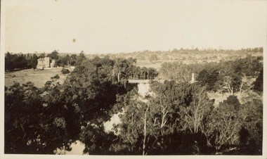 Kew Historical Society Inc
Photograph - Victorian Canoe Club, V.C.C. site, Studley Park, 1920-30
Canoeing on the River Yarra at Melbourne was an important and widespread recreational pursuit for Melbournians, especially in the first half of the twentieth century. The Victorian Canoe Club was formed in 1912 at a meeting in Melbourne and its first committee elected in the same year. Records indicate that the Club continued into at least the 1950s .The album has historic and social significance as a record of recreational activities (as well as canoe making) in the early years of the twentieth century. It has local significance as the site of the headquarters of the Club was in Studley Park. A number of photographs in the album provide vistas of Kew on the Yarra that are otherwise unavailable.One of 24 labelled photos in part album, originating from the Victorian Canoe Club, which had its headquarters in Studley Park, Kew. The album includes a photographic record of canoe construction and also locations in Studley Park and Kew where the canoes were used. The subject of this photograph is identified as 'V.C.C. site, Studley Park'.The panoramic view shows a number of important landmarks during this period. On the left of the photograph is one of the remaining buildings of the Yarra Bend Asylum. Stretching across the river is a suspension bridge on the site of the present Kane's Bridge. The reference to the V.C.C. site is unclear within the context of the photo which appears to be taken from the vicinity of the Johnston Street Bridge."V.C.C. site, Studley Park"victorian canoe club, river yarra, canoe clubs, yarra bend asylum, suspension bridge -- kew, kane's bridge, studley park -
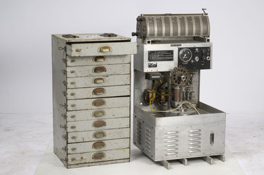
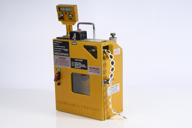 Department of Energy, Environment and Climate Action
Raindance Aerial Incendiary Machine R2
Alan McArthur from the CSIRO began his experimental burning program in the late 1950s near Canberra and published his landmark paper in 1962, “Controlled burning in eucalypt forests”. Leaflet No. 80, as it was known, proved a turning point for forest and fire managers across Australia. It led to the McArthur Forest Fire Danger Meter (FFDM) which first appeared in operational use in 1967 as the Mk 4. The CSIRO had developed its semi-automatic aerial incendiary machine dropping small capsules, with the first trial from a fixed-wing Cessna 337 at Manjimup in December 1965. Many technological and safety improvements followed including the Raindance machineAerial Incendiary Machine developed in Western Australia Rather than "ping pong balls" it uses a belt of incendiary "caplets" which are injected inside the machine before being ejected Raindance Systems R2forests commission victoria (fcv), planned burning, bushfire aviation, bushfire -
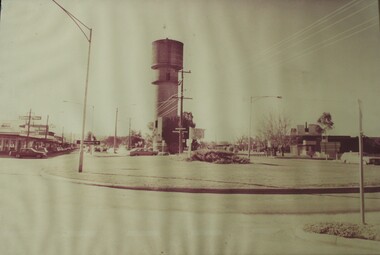 Wodonga & District Historical Society Inc
Photograph - Wodonga Water Tower, July 1984
THE WATER TOWER is a major landmark of High Street, Wodonga. It began operation from 1924 until it ceased operation in 1959. It stood unused for a decade until the lower section was modified and put to use as “ The Tower’s Cobbler’s Inn” in 1962. In 1972 Wodonga City Council proposed to demolish the Tower. Their suggestion received an unfavorable response from the city’s citizens, so the Tower still stands today. This image shows High Street and Hovell Street looking to the north The Civic Centre Theatre is on the right in Hovell Street. On the left in High Street is Tower Place on left. On the far left Repco which by 1998 became a Chinese restaurant and remains so in 2022.This photo is significant as it depicts a major building which has been used to represent the city of Wodonga in many souvenirs and publications over time.One of many photos of the Wodonga Water Tower in our collection. It is a large black and white image which has been mounted in a metal frame.wodonga water tower, wodonga city -
 Federation University Historical Collection
Booklet, Ballarat School of Mines Annual Report. 1913, 1913
Sheetmetal was introduced to the Ballarat School of Mines in this year, as was the Ballarat Junior Technical School - a division of the Ballarat School of Mines. Assay and Chemical Laboratories remodelled. It was decided that the new Ballarat Technical Art School would be built on the site of the former Circuit Courthouse, which for many years served as a Museum for the School. It was noted that demolishing this building would remove one of the very oldest landmarks of Ballarat. Swinger operated between 1972 and 1975 at Ballarat Civic Hall. The Ballarat Observatory was transferred to the Ballarat East Council. Thomas S. Hart resigned to fulfil the position of Head Master of the School of Forestry at Creswick. B. Whitington resigned to fill the position of Directorr of the School of Mines at Queenstown, Tasmania. Two printed copies of the Ballarat School of Mines Annual Report for the year 1913. ballarat school of mines annual report, ladies' art association, sheetmetaltrades, albert steane, ballarat observatory, ballarat technical art school, former circuit courthouse, thomas hart, creswick school of forestry, queenstown, b. whittington, ralph williams, charles fenner, university of melbourne, donald clark, w.h. middleton, swinger -
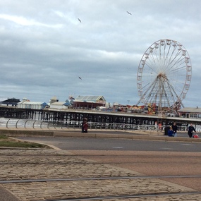 Ballarat Heritage Services
Digital photographs, Blackpool 2016, 2016
Black pool was one of the first seaside towns to experience middle and lower class visitations in the Edwardian period. The Blackpool tower is noted as an iconic landscape. "Blackpool is a seaside resort on the Irish Sea coast of England. It's known for Blackpool Pleasure Beach, an old-school amusement park with vintage wooden roller coasters. Built in 1894, the landmark Blackpool Tower houses a circus, a glass viewing platform and the Tower Ballroom, where dancers twirl to the music of a Wurlitzer organ. Blackpool Illuminations is an annual light show along the Promenade. Weather: 8 °C, Wind SE at 18 km/h, 81% Humidity Local time: Wednesday 8:44 am Postcode: FY1-FY4" wikipediaDigital images in colour -
 Department of Energy, Environment and Climate Action
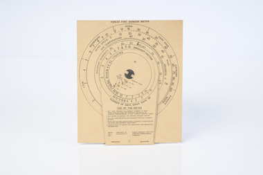
McArthur Forest Fire Danger Meter MK5 1973
The Forest Fire Danger Index (FFDI) was originally invented by the grandfather of Australian bushfire science, Alan Grant McArthur, during the 1950s and ‘60s. Alan published his landmark paper, “Controlled burning in eucalypt forests” in 1962. Leaflet No. 80, as it was known, proved a turning point for forest and fire managers across Australia. More importantly, Alan was very practical forester and wanted his work to be useful to people in the field, so after several iterations he came up with the now familiar circular slide rule called the Forest Fire Danger Meter (FFDM). The Mk 4 version first appeared in operational use in 1967. This is the Mark 5 from 1973Alan McAthur's scientific legacy with the FFDI meter is unquestionably huge and has served forest firefighters very well over the decades.Cardboard fire danger meter Series of circular slide rules to calculate Forest Fire Danger Index (FFDI)forests commission victoria (fcv), bushfire -
 Forests Commission Retired Personnel Association (FCRPA)
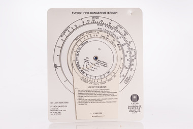
McArthur Forest Fire Danger Meter - Mk 5, 1992
The Forest Fire Danger Index (FFDI) was originally invented by the grandfather of Australian bushfire science, Alan Grant McArthur, during the 1950s and ‘60s. Alan published his landmark paper, “Controlled burning in eucalypt forests” in 1962. Leaflet No. 80, as it was known, proved a turning point for forest and fire managers across Australia. More importantly, Alan was very practical forester and wanted his work to be useful to people in the field, so after several iterations he came up with the now familiar circular slide rule called the Forest Fire Danger Meter (FFDM). The Mk 4 version first appeared in operational use in 1967. This is the Mark 5 from 1992Alan McAthur's scientific legacy with the FFDI meter is unquestionably huge and has served forest firefighters very well over the decades.Control burning meter Series of circular slide rules to calculate Forest Fire Danger Index (FFDI)bushfire, forests commission victoria (fcv) -
 Kew Historical Society Inc
Work on paper - Sepia Wash & Ink, G B Richardson, Creek and Old Watering Stage, on the Yarra, East Collingwood, 1854, 1854
Blind Creek was located between the Abbotsford Convent and what is now the Collins Bridge in Studley Park. In an 1858 map of East Collingwood by Clement Hodgkinson, in the State Library of Victoria, one can see how the creek was originally a significant landmark in Collingwood; remaining vacant land until a barrel drain enclosed it. The area was later filled in, surveyed and developed. The position where Blind Creek entered the Yarra was in the immediate vicinity of Hodgson’s Punt, which had linked Kew to the other side of the Yarra from 1839. The Punt was purchased by the Colonial Government in 1852 and was in use until the opening of the Studley Park Road (Johnston Street) Bridge in 1858 made its continued use redundantThe point of view selected by the artist for the watercolour is from the banks of Blind Creek in East Collingwood, looking across the Yarra to the Kew side of the river.Inscribed verso 'Creek and Old Watering stage, on the Yarra East Collingwood 1854 / Trees, stage, &c have long since disappeared / [Artist Signature] / FT 110 / Creek itself now being filled in 1903.gb richardson, blind creek - abbotsford, yarra river - abbotsford (vic) - kew (vic), colonial artists, australian art - 19th century, george bouchier richardson -
Frankston RSL Sub Branch
Framed Artwork, Sketch of Frankston RSL Clubrooms, Davey Street, 1972
Framed artwork produced by artist Marie Minton, dated 1972. The artwork is an ink drawing with watercolour tonings and depicts the Frankston RSL Sub Branch clubrooms of the time. The artwork is mounted with a gold coloured wooden frame and glass front. Artist, Marie Minton was apparently the daughter of a member of the time, Laurie Minton. This scene is of a Frankston landmark building on the corner of Davey Street and Young Street, Frankston locally known as the 'Plowman Residence'. Prior to being the clubrooms of the Frankston RSL Sub Branch this building was the family home of Dr Sidney Plowman. In Dr Plowman's time the building was known as the 'The Lofts' and was his residence and operated as a private hospital, the building was constructed ca 1900. Dr Plowman died in May 1932. Title 'Frankston RSL' and the artist's name 'Marie Minton '72' appear on the front lower area of the sketch. The rear has the following note inscribed "Sketch of RSL clubrooms Davey St. by Marie Minton daughter of member (Laurie)" -
Victorian Aboriginal Corporation for Languages
Book, Helen Gardner et al, Southern Anthropology : a History of Fison and Howitt's Kamilaroi and Kurnai, 2015
From far-flung sites in Australia and the Pacific Islands, Lorimer Fison and A. W. Howitt produced the landmark study, 'Kamilaroi and Kurnai' (1880). Their book revealed the complexity of Aboriginal and Pacific Island societies and changed the course of anthropology in the early years of the discipline. Using archival sources and an innovative approach, Southern Anthropology explores the research, writing and reception of 'Kamilaroi and Kurnai'. Historical chapters track Fison and Howitt's collection and analysis of anthropological material in the context of raging debates about the evolution of humans. This narrative is interspersed with an introduction to the kinship and social organisation of Aboriginal and Pacific Island people that highlight the enduring value of Fison and Howitt's methods and the resurgence of their questions in contemporary anthropology. Southern Anthropology is designed to be read across disciplinary boundaries. b&w illustrations, b&w photographs, tables, document reproductionshistories, anthropology, howitt, fisson, kamilaroi, kurnai, evolution, archives, australia -
 Kew Historical Society Inc
Plan - Subdivision Plan, Belford Heights Estate, Kew, ca. 1925
Pru Sanderson, in her groundbreaking ‘City of Kew Urban Conservation Study : Volume 2 - Development History’ (1988), summarised the periods of urban development and subdivisions of land in Kew. The periods that she identified included 1845-1880, 1880-1893, 1893-1921, 1921-1933, 1933-1943, and Post-War Development. These periods were selected as they represented periods of rapid growth or decline in urban development. An obvious starting point for Sanderson’s groupings involved population growth and the associated economic cycles. These cycles also highlighted urban expansion onto land that was predominantly rural, although in other cases it represented the decline and breakup of large estates. A number of the plans in the Kew Historical Society’s collection can also be found in other collections, such as those of the State Library of Victoria and the Boroondara Library Service. A number are however unique to the collection.The Kew Historical Society collection includes almost 100 subdivision plans pertaining to suburbs of the City of Melbourne. Most of these are of Kew, Kew East or Studley Park, although a smaller number are plans of Camberwell, Deepdene, Balwyn and Hawthorn. It is believed that the majority of the plans were gifted to the Society by persons connected with the real estate firm - J. R. Mathers and McMillan, 136 Cotham Road, Kew. The Plans in the collection are rarely in pristine form, being working plans on which the agent would write notes and record lots sold and the prices of these. The subdivision plans are historically significant examples of the growth of urban Melbourne from the beginning of the 20th Century up until the 1980s. A number of the plans are double-sided and often include a photograph on the reverse. A number of the latter are by noted photographers such as J.E. Barnes.The Belford Heights Estate was a subdivision in Kew East, even though the title of the plan indicates that it was located in Kew. The subdivision had been approved by 1915, and included 105 lots facing Strathalbyn, Kitchener, Hamilton and Beresford Streets, as well as Balfour and Belford Roads. Those lots hand coloured with red probably represent blocks that had been sold. The additional information provided on the plan is also of interest. The plan includes the original location of East Kew State (Primary) School in Strathalbyn Street, which opened in 1892. The inset Locality Plan also includes the route of the Outer Circle Railway and the location of the Wilsmere and East Kew Stations. The location of the landmark Harp of Erin Hotel is also marked on the Locality Plan.belford heights estate, subdivision plans - kew -
 Orbost & District Historical Society
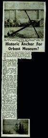
newspaper clippings, 1928 - 1975
These newspaper articles were collated by Mary Gilbert. Mary Isabelle Gilbert was born in 1905 in Orbost, Australia. She was born to John Gilbert and Annie Cameron Gilbert, and had seven sisters and one brother. Four siblings died at a young age. She was a teacher historian loved and respected by her family and the wider community.These articles are contemporary records of events in the history of Orbost and as such are useful reference tools.A manila folder containing black / white newspaper cuttings of articles relating to the local history of Orbost. They are from the Snowy River Mail. 746.1 is titled, "Historic anchor for Orbost Museum". 746.2, August 9, 1967, is titled, ""Orbost Historical Museum". 746.3 is titled, "When The Snowy Was Angry". On the back is "Resident's Sudden Death - Mrs Ada Bowtell (67)". 746.4 from 1934 is titled, "The Duke's Visit - Welcome at Cann River'. 746.5, Wednesday November 24, 1954 is titled, "Naming of Orbost District Landmarks". 746.6, Wednesday November 24, is titled, " Convict First White Settler in Orbost District?". 746.7, Wednesday, July 25, 1928 is titled, " Dedication of St James' Memorial Church, Orbost". 746.8 and 746.9, Wednesday September 24, 1975 are titled, "Piece of History Returns".orbost- museum anchor-orbost street-names-orbost st-james'-orbost -
 Warrnambool and District Historical Society Inc.
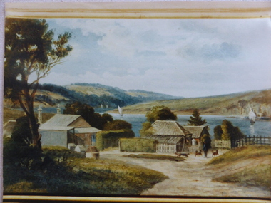
Photograph, Old Lyndoch - Photograph of Painting, Late 19th century (original painting); late 20th century (photograph of painting)
This is a photograph of a painting by the noted artist George Webb (1861-1949). Webb was best known for his portraits of civic dignitaries in Melbourne and Adelaide but he also produced many landscapes and seascapes. Some of these feature Warrnambool landmarks as he married, in the late 1890s, Christina Lake, the step-daughter of George Rolfe who owned the property known as ‘Lyndoch’, near the mouth of the Hopkins River. Webb painted the early cottages at ‘Old Lyndoch’ using a photograph taken some time earlier. The painting was given to Dick Allan, the chauffeur in the employ of Florence Lake, Christina’s sister. Florence Lake owned and resided at Lyndoch after her parents’ death. Dick Allan’s son, living in Tasmania, acquired the painting and Les O’Callaghan obtained the photograph of the painting from him. Although this is only a photograph of an original painting, it is of some considerable importance as the painting has great historical significance and this is the only representation we have of it. The man in the photograph represents George Rolfe and the story of Rolfe and his ownership and development of the property of Lyndoch is an important one in Warrnambool’s history. The original by George Webb is also an important work of art in its own right.This is a colour photograph of a painting. The frame of the original painting can be seen at the bottom of the photograph. The photograph is in on old frame which has two wooden edgings with the outer one having an ornate gold plaster edging and an inner one with a gold velvet insert next to the glass. The ornate gold plaster has a piece missing near the top left hand corner. The photograph is set into a gold-coloured wooden frame inside the glass. The photograph is mounted onto cardboard and covered with cardboard at the back with a small piece of wood attached (from the original frame). The backing is nailed on. lyndoch, george webb, george rolfe -
 Federation University Art Collection
Oil & acrylic on linen, 'Guitar 2003' by Robert Jacks, 2006
Robert JACKS (1943-2014) Jacks studied sculpture at Prahran Technical College from 1958–1960 and painting at RMIT in 1961–62. His first solo exhibition was held to great acclaim in 1966 and in 1968 his work was included in the landmark exhibition, The Field, at the National Gallery of Victoria. Beginning in 1968, Jacks spent ten years living and working in Canada and the United States. It was during this period that his unique visual language matured, incorporating influences from the major exponents of contemporary abstraction, minimalism and conceptual practice. In 2001 the Bendigo Art Gallery established the Robert Jacks Drawing Prize. In 2006, he was named an Officer of the Order of Australia (AO) This item is part of the Federation University Art Collection. The Art Collection features over 2000 works and was listed as a 'Ballarat Treasure' in 2007.art, artwork, robert jacks, the field, abstraction, contemporary art -
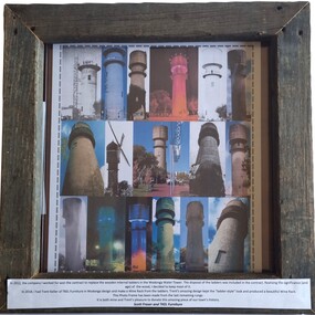 Wodonga & District Historical Society Inc
Memorabilia - Water Tower Picture Frame
The Water Tower is a major landmark of High Street, Wodonga. Construction of the Water Tower was completed in early 1924 and after thorough testing throughout that year, the completed new water system for Wodonga was officially opened on 4th December 1924. It was decommissioned in 1959. It stood unused until the lower section was modified and put to use as “ The Tower’s Cobbler’s Inn” in 1962. In 1972 Wodonga City Council proposed to demolish the Tower. Their suggestion received an unfavorable response from the city’s citizens, so the Tower still stands today. The community celebrated its centenary on 4th December 2024. This picture frame was created from timber taken from the ladders that were inside the Tower, allowing access to the water tank itself and the external balconies. It was donated to the Wodonga & District Historical Society at the Centenary Celebration.This item is significant because it is made from timber from the original ladders inside the Wodonga Water Tower.A timber frame made from sections of timber from the ladders once part of the Wodonga Water Tower.On sign at base on frame: In 2012, the company I worked for won the contract to replace the wooden internal ladders in the Wodonga Water Tower. The disposal of the ladders was included in the contract. Realising the significance (and age) of the wood, I decided to keep most of it. In 2018, I had Trent Keller of TKEL Furniture in Wodonga design and make a Wine Rack from the ladders. Trent's amazing design kept the "ladder-style" look and produced a beautiful Wine Rack. This Photo Frame has been made from the last remaining rungs. it is both mine and Trent's pleasure to donate this amazing piece of our town's history. Scott Fraser and TKEL Furniturewodonga water tower, landmarks wodonga -
 Eltham District Historical Society Inc
Document - Property Binder, 559 Main Road, Eltham
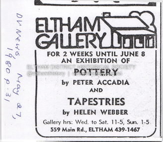
Newspaper advertisement: Diamond Valley News, 27 May 1980, Exhibition, Peter Accadia, pottery, and Helen Webber, tapestries. Newspaper article: Five for the price of one, Diamond Valley News, Tuesday, July 8, 1986, p27; exhibition of five artists at Eltham Gallery. On reverse, numerous advertisements for food and entertainment Newspaper advertisement: The Age ,17 June 1989, Exhibition, Donald Ramsay "Watching the river flow". Newspaper article: Landmark gallery says goodbye, Diamond Valley Leader, 24 November 2004, Gallery site sold to Sentinel Equities, present tenant Julie Skate, quotes from former part-owner Val Murray. Newspaper article: Rift over gallery plans, Diamond Valley Leader, 21 February 2007, purchasers Jethro Tull and Suzanne Still plan to build offices, gallery and cafe; Eltham Gateway Action Group objected while supporting need for a gallery elsewhere. Newspaper article: New try for gallery-cafe ready soon, Diamond Valley Leader, 18 April 2007, purchaser Jethro Tull to have a new plan ready in two weeks for gallery and cafe. Newspaper article: Gateway for artists, Diamond Valley Leader, 25 May 2007, Jenni Mitchell opened a new gallery pending decision by Nillumbik Council. Newspaper article: Art gallery proposal rejected, Diamond Valley Leader, 30 May 2007, Nillumbik Council against planned new building. Newspaper article: Artful win for gallery, Diamond Valley Leader, 30 January 2008, VCAT approved mudbrick art gallery. Newspaper article: Rocky road to create a landmark, Diamond Valley Leader, 13 February 2008, VCAT approved Robert Marshall's design, artists's impression, Eltham Gateway Action Group opposed.main road, property, businesses, eltham gallery, wiregrass gallery, eltham gateway action group, robert marshall, mud brick building, eltham (vic), 559 main road eltham, artists, bernhard rust, bob smith, jan neil, john adams, marian sussex, michael wilson, tony dopheide, 47-55 main street diamond creek, 50 were street montmorency, 55 rattray road montmorency, 410 main road lower plenty, abbey of diamond creek, adams north riding restaurant, advertising, eltham barrel, montmorency, mustard seed restaurant, peking house restaurant, st andrews, tamara's -
 Blacksmith's Cottage and Forge
Matchbox and Matchbox Holder, Box : Bryant and May's, early 20th. century
The Bryant and May Factory is located in the suburb of Cremorne in Melbourne, Australia. It was constructed in 1909 as the Empire Works to a design by prolific Melbourne architect William Pitt. It was purchased soon after by British safety match manufacturer Bryant and May who significantly expanded the building adding an additional level and the landmark clock tower. Bryant and May were unique in that they operated as a model factory providing workers with conditions and amenities which even today seem generous. These included a dining hall and sports facilities such as a tennis court and bowling green which were constructed in the 1920s. Bryant and May ceased Australian match manufacture in the early 1980s as a result of import competition. Their iconic Redheads matches are now imported from Sweden. The complex has since been converted for use as offices and showrooms but is extremely well preserved. It is listed on the Victorian Heritage Register. Source: www.wikipedia.org Local social history of Bacchus MarshMetal matchbox holder for a matchbox-one side has a photo of a local cricket team, the other side has a caricature of a man's face when held one way up is smiling and when turned up the other way the face is looking unhappy. The cover is blue with yellow. The matchbox cover is made of a thin veneer wood. The makers inscription is in blue and red.Cover/spine: Strike The Border Inn Bacchus Marsh for a good spot Phone 16 Cyril Jones, Proprietor. Cover/side: This man always calls in at the Border Inn. This Man wishes he did Matchbox:Bryant & May's "Crown" Safety Matchesbox, souvenir, sport, item, cricket, match, team, cyril, jones, border, inn, cover, novelty -
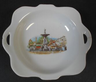 Bendigo Historical Society Inc.
Memorabilia - Alexandra Fountain Souvenir Plate
Alexandra Fountain is a fountain in the Australian city of Bendigo, Victoria. It is regarded as one of the city's most prominent landmarks and monuments The fountain is located in Bendigo's Charing Cross area at the intersection of View Street and Pall Mall. Charing Cross effectively stands at the centre of the city and is one of Bendigo's busiest and most prominent intersections. The fountain stands opposite the main entrance of Rosalind Park. Alexandra Fountain was funded from the proceeds of the Bendigo Juvenile Industrial Exhibition (1879), a £500 gift from George Lansell and a further £700 from the Sandhurst City Council (now the City of Greater Bendigo). The fountain was designed by William Vahland (1828–1915), a local architect responsible for some of the city's most prominent buildings. The fountain was named in honour of Alexandra, Princess of Wales. Its grand opening on 5 July 1881 was attended by her sons Prince Albert and Prince George.White shallow bowl with transfer of Alexandra Fountain in centreMade in Japanalexandra fountain, bendigo landmarks -
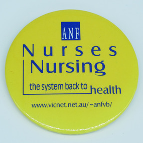 Australian Nursing & Midwifery Federation
Australian Nursing Federation ratios campaign badge, 2001
Button distributed to and worn by Australian Nursing Federation (ANF) members and staff as part of a campaign to secure minimum nurse staffing in the public healthcare sector. This badge was accompanied by a booklet 'Nursing the system back to health : Nurse patient ratios 2001', published in April 2002. The booklet describes some of the rationale for minimum staffing ratios and developments in 2000-2001 regarding campaigning for ratios, particular the landmark decision of the Australian Industrial Relations Commission in 2000 that saw the ANF securing the world's first mandated minimum nurse-to-patient ratios. After decades of campaigning from the ANF/ANMF, ratios were legislated for the public sector in Victoria with the passing of the Safe Patient Care (Nurse to Patient and Midwife to Patient) Bill in 2015. The web address on the badge was active from 1999 to 2004, and the shortcut 'anfvic.asn.au' was active from April 2001, suggesting this badge dates from 2001.Circular yellow, blue and white badge. Silver metal, plastic-coated, with safety pin fastener adhered to back. Badge printed with a blue and white ANF [Australian Nursing Federation] logo, the text 'Nurses Nursing the system back to health' and the (then) website of the ANF (Victorian Branch), 'www.vicnet.net.au/~anfvb/'.nursing, ratios, workforce, staffing, nurses, unionism, badges, buttons, pins, campaigning, trade unions, labour history, safe patient care (nurse to patient and midwife to patient ratios) act 2015, australian nursing federation, victoria, enterprise bargaining -
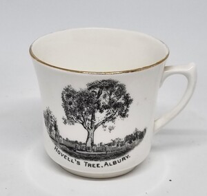 Wodonga & District Historical Society Inc
Souvenir - Cup Hovell's Tree, Albury
This souvenir represents the Hovell Tree, a local historic landmark in Albury, NSW. This item is from a collection donated by descendants of John Francis Turner of Wodonga. The Hovell Tree commemorates the exploration and naming of the Hume River (now the Murray) by Hume and Hovell`s expedition of 1824. In 1824, Governor Brisbane asked Hume to join forces with an English sea captain, William Hovell, to go from Lake George to the Spencer Gulf in South Australia. The Hovell Tree, marked by William Hovell on November 17, 1824 was flanked by another tree marked by Hamilton Hume which was destroyed by fire in the 1840's. The river gum was marked by William Hovell when discovering river. Hume and Hovell travelled from the Yass area and after crossing the Murray River where Lake Hume now is, they crossed the Mitta Mitta River and proceeded to Corio Bay, Westernport.This item is representative of souvenirs produced to represent key buildings and historic landmarks in the Albury-Wodonga district.A white cup with gilt trim around the lip. It bears an image of the Hovell Tree in Albury, NSWBeneath image: "HOVELL'S TREE, ALBURY."albury souvenirs, hovell tree, hume and hovell, australian exploration -
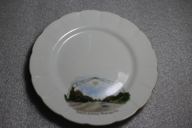 Wodonga & District Historical Society Inc
Memorabilia - Souvenir Plate Pollard Arch, Wodonga, Victoria, C. 1960s
A wide range of souvenirs have been produced to commemorate Wodonga and its landmarks over time. These items document key changes in Wodonga and its heritage. The arch is named in honour of Cr Charles Pollard, a foundation member of the Wodonga Show Society and former Wodonga Shire councillor and president. The arch is 29 metres wide and 15 metres high and consists of two boomerangs coming together to form an archway. Originally spanning across a single carriageway of the Lincoln Causeway, the arch was opened by Princess Alexandra of Kent in 1959 and was built for £1230. When the Country Roads Board said the causeway would have to be duplicated in 1973, a new home was required for the arch. At the request of the Wodonga Show Society, the arch was moved to the entrance of the showgrounds in 1982. After development of the precinct in 2015, the Pollard Arch was erected on Hamilton Smith Drive Wodonga.Small china pieces carrying scenic views of holiday destinations were a popular kind of souvenir during much of the 20th century. These items have local and social significance as they reflect the landmarks or local features valued by the community over time.Fine china round plate, white with image of the Pollard Archway in Wodonga, Victoria in the bottom third of the plate. Inscription below the image.On bottom of image "Pollard Archway, Wodonga, Vic". Manufacturer's mark on back "St Kilda/ Fine China/ Australia / Hand Painted"souvenir, wodonga, victoria, pollard archway, landmarks wodonga -
 Department of Energy, Environment and Climate Action
CSIRO Incendiary Machine
Alan McArthur from the CSIRO began his experimental burning program in the late 1950s near Canberra and published his landmark paper in 1962, “Controlled burning in eucalypt forests”. Leaflet No. 80, as it was known, proved a turning point for forest and fire managers across Australia. It led to the McArthur Forest Fire Danger Meter (FFDM) which first appeared in operational use in 1967 as the Mk 4. The CSIRO had developed its semi-automatic aerial incendiary machine dropping small capsules, with the first trial from a fixed-wing Cessna 337 at Manjimup in December 1965. In April 1969, the Forests Commission borrowed the second prototype of the CSIRO machine to carry out fuel reduction burning at Orbost. The success prompted the purchase of their own machine in 1970, which now sits in the Altona Museum. Pioneering machine in the development of aerial ignition in AustraliaAerial Incendiary Machineforests commission victoria (fcv), planned burning, bushfire aviation, bushfire -
 Kew Historical Society Inc
Photograph, J F C Farquhar, Railway Bridge Over the Yarra, 1891
At the beginning of the 1890s, the Kew businessman and Town Councillor, Henry Kellett, commissioned J.F.C. Farquhar to photograph scenes of Kew. These scenes included panoramas as well as pastoral scenes. The resulting set of twelve photographs was assembled in an album, Kew Where We Live, from which customers could select images for purchase.The preamble to the album describes that the photographs used the ‘argentic bromide’ process, now more commonly known as the gelatine silver process. This form of dry plate photography allowed for the negatives to be kept for weeks before processing, hence its value in landscape photography. The resulting images were considered to be finely grained and everlasting. Evidence of the success of Henry Kellett’s venture can be seen today, in that some of the photographs are held in national collections.It is believed that the Kew Historical Society’s copy of the Kellett album is unique and that the photographs in the book were the first copies taken from the original plates. It is the first and most important series of images produced about Kew. The individual images have proved essential in identifying buildings and places of heritage value in the district.Completed in November 1890, the railway viaduct (now the Chandler Highway Bridge) linked Kew and Fairfield. The viaduct is significant as the most substantial extant engineering remnant of the Outer Circle Railway Line. Opened in March 1891, the viaduct crossed the Yarra River in a single span, atop three supporting brick pillars. Following the closure of the railway line in 1927, and the construction of the Chandler Highway in 1930, the bridge was used for vehicular traffic. In 1891 when this panoramic photograph was taken, the grounds of what was then the Kew Lunatic Asylum extended down to the River and eastward beyond the viaduct. The landscape surrounding the Asylum was planted with traditional exotic trees such as Oaks, Pines and Cedars, and landmark trees from northern Australia such as the Hoop Pine. Remnant indigenous trees such as the River Red Gum, Yellow Box and Lightwood were scattered around the site, including beside the Yarra River.Railway Bridge Over the Yarrakew illustrated, kew where we live, photographic books, henry kellett, railway viaduct - - kew (vic)