Showing 523 items
matching lands department
-
 The Beechworth Burke Museum
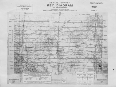
Photograph - Aerial Survey, 5/9/1947
... department of lands and survey... and surrounding area. Issued by Department of Lands and Survey, Victoria..., APPROXIMATE SCALE OF MILES / DEPARTMENT OF LANDS AND SURVEY VICTORIA... and surrounding area. Issued by Department of Lands and Survey, Victoria ...This image is an Aerial Survey, Key Diagram of Beechworth and surrounding area. Issued by Department of Lands and Survey, Victoria in 1947. Photographed at an average height of 12300 feet above sea level, areas depicted are; Beechworth, Stanley, Bruarong, Baranduda, Muagegonga, Myrtleford, Everton, Wooragee North Tarrawinge, Dederang, Kergunyah North, Kergunyah, Yackandandah, El-Dorado, Barambogie, Murmungee, Barwidgee, Oxley, CarraragarmungeeBlack and white rectangular photograph. Image is printed on matt photographic paper and has a white un-printed border. Obverse: AERIAL SURVEY, KEY DIAGRAM OF PHOTOGRAPHS, APPROXIMATE SCALE OF MILES / DEPARTMENT OF LANDS AND SURVEY VICTORIA 5.9.1947. BEECHWORTH 792 ZONE 7. Reverse: BMM7010.1 (written in pencil) aerial survey, beechworth, burke museum, department of lands and survey, victoria, 1947 -
 Federation University Historical Collection
Map - Geological, Tallangatta, New South Wales: 1:250,000 Geological Series, SJ 55-3, 1966, 1966
... department of lands... Hydro Electrical Authority, Department of Lands, County maps... Electrical Authority, Department of Lands, County maps and Snowy ...Compiled by the Geological Survey of N.S.W., Division of Regional Geology. Topographical base compiled from Snowy Mountains Hydro Electrical Authority, Department of Lands, County maps and Snowy Lease Map. Other sheet adjoin this map. There are 13 formation sections grouped into 9 - Quaternary, Tertiary, Middle Devonian, Lower to Middle Devonian, Lower Devonian, Upper Silurian, Silurian, Upper Ordovician and Ordovician.Large coloured map showing geological features, faults, bores, rivers and mineral deposits.Scale of map, longitude and latitude, river names. "Tallangatta 1:250,00" written in black pen.tallangatta, new south wales, geological survey, topographical base, snowy mountains hydro electrical authority, department of lands, snowy lease map, department of mines, quaternary, tertiary, middle devonian, lower to middle devonian, lower devonian, uper siluran, silurian, upper ordovician, ordovician -
 Bendigo Historical Society Inc.
Map - DIGGORRA PARISH : COUNTY OF BENDIGO, 6-9-21
... Railway. Photo-Lithographed at the Department of Lands and Survey... at the Department of Lands and Survey, Melbourne by W.J. Butson, 6-9-21 ...Map. Parish of Diggorra, County of Bendigo, Parish of Bamawm, Rochester West, Pannoomilloo, Warragamba, Minto, Egerton, Elmore, Northern Railway, Parish of Ballendella. Elmore /Cohuna Railway. Photo-Lithographed at the Department of Lands and Survey, Melbourne by W.J. Butson, 6-9-21, Price 1/-.. By authority A.J. Mullett, Government Printer. (number 57 in map cupboard 1)A.J. Mullett, Government Printer.map, bendigo, diggorra -
Bendigo Historical Society Inc.
Map - JANIEMBER EAST : COUNTY OF BENDIGO, 15-1-34
... at the Department of Lands and Survey, Melbourne, Victoria. Price 2/-. 15-1.... Printer, Melbourne. Drawn and reproduced at the Department ...Map. Janiember East, County of Bendigo, Jarklan, Pompapiel, Yarrayne, Powlet, Janiember West, Serpentine Creek, Caney's Blind Creek Long Plain Creek, Loddon River. By authority : H.J. Green, Govt. Printer, Melbourne. Drawn and reproduced at the Department of Lands and Survey, Melbourne, Victoria. Price 2/-. 15-1-34. (number 45 in map cupboard 1)H.J. Green, Govt. Printer, Melbourne.map, bendigo, janiember east -
 Bayside Gallery - Bayside City Council Art & Heritage Collection
Map, Department of Crown Lands and Survey et al, Moorabbin, County of Bourke, Government Roads, 1920
... Department of Lands and Survey... from the Secretary for Department of Lands and Survey (dated 26...Department of Crown Lands and Survey... Foreshores Hampton Beaumaris Highett Cheltenham Department of Lands ...The cadastral map of the Parish of Moorabbin in Victoria (L.6104) shows parish boundaries and land ownership 1920 when Sandringham was a Town. The government roads have been coloured in red pencil.moorabbin, county of bourke, map, plan, land subdivision, land titles, foreshores, hampton, beaumaris, highett, cheltenham, department of lands and survey, land owners, cartographic material, brighton, sandringham, town of sandringham, government roads -
Bendigo Historical Society Inc.
Map - HEATHCOTE : COUNTY OF BENDIGO, May 1952
... at the Department of Lands and Survey, Melbourne. May 1952, Price 2... Printer, Melbourne, Drawn and reproduced at the Department ...Map. Heathcote, County of Bendigo, County of Housie, Knowsley, Knowsley East, Langwornor, Tooborac, Warrowitue, Costerfield, Dargile, Township of Heathcote, Meadows Valley Creek, Wallan and Bendigo Railway, C.R.B. Main Road. By authority J.J. Gourley, Government Printer, Melbourne, Drawn and reproduced at the Department of Lands and Survey, Melbourne. May 1952, Price 2/-. (number 89 in map cupboard 1)J.J. Gourley, Government Printer, Melbourne.map, bendigo, heathcote -
Bendigo Historical Society Inc.
Map - MARONG : COUNTY OF BENDIGO, June 1953
... at the Department of Lands and Survey, Melbourne, Victoria. June 1953. Price... Printer. Drawn and reproduced at the Department of Lands ...Map. Marong, County of Bendigo, Nerring, Sandhurst, Lockwood, Shelbourne, Woodstock, Leichardt, Fletcher Creek, Bullock Creek, Township of Marong, Marong Railway Station, Bendigo Railway Line, Spring Creek, Crusoe Aqueduct. By authority W.M. Houston, Government Printer. Drawn and reproduced at the Department of Lands and Survey, Melbourne, Victoria. June 1953. Price 2/-. (number 73 in map cupboard 1)W.M. Houston, Government Printermap, bendigo, marong -
Bendigo Historical Society Inc.
Map - REDESDALE : COUNTY OF BENDIGO, 24-12-24
... , Melbourne. Photo-Lithographed at the Department of Lands and Survey.... Photo-Lithographed at the Department of Lands and Survey ...Map. Redesdale, County of Bendigo, County of Dalhousie, Kimbolton, Langwornor, Spring Plains, Glenhope, Emberton, Metcalfe, Hawkestone, County of Talbot, Campaspe River, Back Creek, River Coliban, Lyell. By authority H.J. Green, Government Printer, Melbourne. Photo-Lithographed at the Department of Lands and Survey, Melbourne by W.J. Butson, 24-12-24, Price 1/-. (number 120 in map cupboard 1)H.J. Green, Government Printer, Melbourne.map, bendigo, redesdale -
Clunes Museum
Document - LAND LICENCE
... DEPARTMENT OF LANDS AND SURVEY....1 LICENCES FOR DEPARTMENT OF LANDS AND SURVEY - OCCUPATION... FOR DEPARTMENT OF LANDS AND SURVEY - OCCUPATION BRANCH. LICENCE NO 315892 ....1 LICENCES FOR DEPARTMENT OF LANDS AND SURVEY - OCCUPATION BRANCH. LICENCE NO 315892 TO 315901. 25 FEBRUARY 1901 TO FEBRUARY 1902 STAPLED TOGETHER .2 LAND ACT 1869 SEC 20 BOOK 88. ON SPINE "THE CROWN - LAND ACT1869. SEC 20. 88 RECEIPTS FROM REVENUE OFFICE NO 2 TO 118 RECEIPTS 119 TO 249 HAVE NOT BEEN USED, THEY ARE CUT IN HALF.2 WHITE ROUND STICKER WITH "5" ON FRONTdepartment of lands and survey, land act 1869, occupation branch, revenue office -
 Bayside Gallery - Bayside City Council Art & Heritage Collection
Map, Department of Lands and Survey, Land under the control of the City of Sandringham, 1962
... department of lands and survey...Print. Map in black ink on cream paper by the Department...Department of Lands and Survey... cheltenham department of lands and survey cartographic material ...The cadastral map showing land under the control of the City of Brighton in 1962.map, plan, foreshores, sndringham, hampton, beaumaris, cheltenham, department of lands and survey, cartographic material, moorabbin, black rock, street map, city of sandringham, board of lands and works -
 Federation University Historical Collection
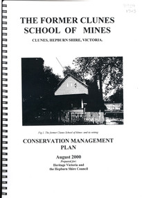
Book, The Former School of Mines Clunes Conservation Management Plan, 2000, 08/2000
... information, structural engineers Report, Department of Lands Survey... and keeping information, structural engineers Report, Department ...The Clunes School of Mines was a campus of the Ballarat School of Mines. The conservation plan was prepared for Hepburn Shire Council and Heritage Victoria to guide the future management of the former Clunes School of Mines in Service Street, Clunes, The building was opened in February 1892 as the Clunes branch of the Ballarat School of Mines, and ceased operating in June 1893.Spiral bound black and white copy of the Conservation Plan for the Clunes School of Mines. Contents include the history, chronology development, context of the building and site, current and past function of the building, original fabric, impact of later alterations, condition of the building, statement of significance, conservation action plan, caring for the site, collecting and keeping information, structural engineers Report, Department of Lands Survey 1955, Memorandum of Agreement 1956.ballarat school of mines, clunes school of mines, australian native association, ana, australian native association clunes branch, eygelaar inner spring mattress factory, clunes infant welfare centre, clunes angling club -
Bendigo Historical Society Inc.
Map - SUTTON GRANGE : COUNTY OF BENDIGO, 21-7-22
... Printer, Melbourne. Photo-Lithographed at the Department of Lands... Printer, Melbourne. Photo-Lithographed at the Department of Lands ...Map. Sutton Grange, County of Bendigo, County of Talbot, Mandurang, Sedgwick, Ravenswood, Hawkestone, Harcourt, Faraday. Myrtle Creek. Victorian Water Supply - Main Line of Aquaduct from Malmsbury to Sandhurst. By authority A.J. Mullett, Government Printer, Melbourne. Photo-Lithographed at the Department of Lands and Survey, Melbourne by W.J. Butson, 21-7-22. Price 1/-. (number 125 in map cupboard 1)A.J. Mullett, Government Printer, Melbourne.map, bendigo, sutton grange -
Bendigo Historical Society Inc.
Map - SUTTON GRANGE : COUNTY OF BENDIGO, 21-7-22
... , Government Printer, Melbourne. Photo-Lithographed at the Department..., Government Printer, Melbourne. Photo-Lithographed at the Department ...Map. Sutton Grange, County of Bendigo, County of Talbot, Mandurang, Ravenswood, Harcourt, Faraday, Hawkestone, Lyell, Sedgwick, Myrtle Creek, Victorian Water Supply - Main Line of Aquaduct from Malmsbury to Sandhurst. By authority A.J. Mullett, Government Printer, Melbourne. Photo-Lithographed at the Department of Lands and Survey, Melbourne by W.J. Butson 21-7-22. Price 1/-. (number 124 in map cupboard 1)A.J. Mullett, Government Printer, Melbourne.map, bendigo, sutton grange -
Bendigo Historical Society Inc.
Map - KNOWSLEY : COUNTY OF BENDIGO, 21-1-19
... . Photo-Lithographed at the Department of Lands and Survey.... Photo-Lithographed at the Department of Lands and Survey ...Map. Knowsley, County of Bendigo, County of Rodney, Weston, Crosbie, Knowsley, Dargile, Heathcote, Shingle Hut Creek, Sheep Station Creek, Forest Creek, Bendigo and Wallan Railway, Mt. Ida Creek. By authority A.J. Mullett, Government Printer, Melbourne. Photo-Lithographed at the Department of Lands and Survey, Melbourne by W.J. Butson 21-1-19, Price 1/-. (number 102 in map cupboard 1)A.J. Mullett, Government Printer, Melbourne.map, bendigo, knowsley east -
 Bendigo Historical Society Inc.
Document - NEVILLE KING COLLECTION: OCCUPATION CERTIFICATE HOMESTEAD FARM NO. 15/939 IN THE NAME OF DAVID WILLIAMS AT A COST OF ONE POUND, DATED 25 SEPTEMBER 1897, 1897
... and distinguished in the maps and books of the Department of Lands... and distinguished in the maps and books of the Department of Lands ...Under the Western Australia 'the Homestead act 1893' an Occupation Certificate, Homestead Farm No. 15/939 for David Williams of Bendigo for 160 acres (near Woolkabunning near Bunbury WA); at a cost of one pound. Signed by order of the Commissioner of Crown Lands. Dated 25 September 1897. The land is marked and distinguished in the maps and books of the Department of Lands and Surveys of the said (WA) Colony as Williams Location No. 702. -
 City of Greater Bendigo - Civic Collection
Administrative record - Land Sales, Department of Lands and Survey et al, 1929
... three Department of Lands and Survey maps pasted in. Index page...Department of Lands and Survey ... Department of Lands and Survey maps pasted in. Index page. Maps have ...This type of album was created by agents auctioning and selling land.Large portfolio style album with green cloth cover bound with three large metal pins. One hundred and then pages with thirty three Department of Lands and Survey maps pasted in. Index page. Maps have handwritten notes and markings throughout in pencil and pen. Covers the Counties of Bendigo, Rodney, Talbot, Gunbower, Gladstone, Tatchera and Karkarooc, Shires of East Loddon and Huntly and Swan Hill District. -
Bendigo Historical Society Inc.
Map - HARCOURT : COUNTY OF BENDIGO, December 1951
... at the Department of Lands and Survey, Melbourne. December 1951. Price 5... at the Department of Lands and Survey, Melbourne. December 1951. Price 5 ...Map. Harcourt, County of Bendigo, County of Talbot, Town of Harcourt, Walmer, Sutton Grange, Ravenswood, Victorian Water Supply Reservoir, in connection with Barkers Creek Reservoir, Barkers Creek, Calder Highway, Northern Railway, Axe Creek. By authority J.J. Gourley, Government Printer, Melbourne. Drawn and reproduced at the Department of Lands and Survey, Melbourne. December 1951. Price 5/- per sheet. (number 100 in map cupboard 1)J.J. Gourley, Government Printer, Melbourne.map, bendigo, harcourt -
Bendigo Historical Society Inc.
Map - HARCOURT : COUNTY OF BENDIGO, December 1951
... .Drawn and reproduced at the Department of Lands and Survey... and reproduced at the Department of Lands and Survey, Melbourne. December ...Map. Harcourt, County of Bendigo, County of Talbot, Ravenswood. Sutton Grange, Walmer, Castlemaine, Faraday, Calder Highway, Northern Railway, Town of Harcourt, Barkers Creek, Victorian Water Supply Res., in connection with Barkers Creek Reservoir. By authority J.J. Gourley, Government Printer, Melbourne .Drawn and reproduced at the Department of Lands and Survey, Melbourne. December 1951. Price 2/- per sheet. (number 96 in map cupboard 1)J.J. Gourley, Government Printer, Melbourne.map, bendigo, harcourt -
 Eltham District Historical Society Inc
Photograph, View looking up 'Policeman's Hill' on Main Road from Dalton Street showing Police Residence, c.1906, 2010c
... Destruction Section of the Department of Crown Lands and Survey... Destruction Section of the Department of Crown Lands and Survey ...For original image see EDHS_00533 This photo was originally mounted on 3mm MDF fibre board with notes and stickers applied as part of a display on the former Police Residence and now present day Local History Centre, home to Eltham District Historical Society; possibly put together by Harry Gilham during his time as president of the society. Eltham Police Station and Residence: A brief history 1860 Eltham Courthouse built in Main Road, together with an adjoining police residence, office, lock–up and stables. 1959 Police Department purchases a house in Pryor Street to be refurbished as Eltham Police Station 1961 Police in Eltham move into Pryor Street refurbished buildings and office. c.1961-1981 Occupied by Vermin and Noxious Weeds Destruction Section of the Department of Crown Lands and Survey. Former Police Station dragged around to rear of Police Residence (prior to August 1967) to make way for the construction of a driveway and access from Main Road. The building was placed on the site of a former Scullery and modified for Lands Department use. 1981 Shire of Eltham take over management of old Police Residence in Eltham. It remains unoccupied for a period of time whilst its future is discussed in Council. 1981-1985 Used for community job creation scheme 1985 Shire of Eltham Parks and Environment occupy the residence. Council improve the driveway but later add a second rear access from Brougham Street due to the dangerous nature of the Main Road entrance. Also add a rear toilet facility between the Police Residence and former Police Station, which was doubling up as a lunch room. Council also commence discussions to re-establish a replica Police Station. c.1986 November. Former Police Station demolished; believed to have been suffering termite damage. c.1989 After some years of discussion a replica Police Station is built, based on photographs, to act as a lunch room and meeting room for Parks and Environment staff and volunteers doing community service. 1996 Eltham District Historical Society in discussions with Nillumbik Shire Council commisioners throughout the year regarding a home for the Society. A proposal put forward by the Society in October to occupy the former Police Residence. 1997 March. Eltham District Historical Society gains access to former Police Residence. 1998 July 12th. Eltham District Historical Society Inc moves into its Local History Centre, 728 Main Road Eltham (the former Police Residnce built in 1860). 2018 July. Eltham District Historical Society gains access to the replica Police Station for use as part of regular heritage tours for schools and community based groups.Black and white photocopyLabels and handwriting in pencil and ink identifying various buildings. Also highlighted is the acetylene gas lamp and on reverse is written "Lamplighter Jimm Saville"728 main road, eltham, local history centre, parks and environment, police residence, police station, shire of eltham -
 Eltham District Historical Society Inc
Document - Property Binder, 906 Main Road, Eltham
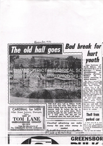
... , Lands Department photograph at 15,500 feet, Alistair Knox quoted..., Lands Department photograph at 15,500 feet, Alistair Knox quoted ...Newspaper article: unidentified possibly Diamond Valley News, November 1970: The old hall goes, photograph of old shire hall part-demolished. Newspaper article: unidentified possibly Diamond Valley News, November 1970: Bad break for hurt youth, Peter Cockrane injured in car accident. Letter Eltham Film Society to Eltham Historical Society, 18 May 1972: Advising of demolition threat to building housing Ashrill Cinema. Newspaper article: The Valley Voice, 19 October 1978, A birds eye view, Lands Department photograph at 15,500 feet, Alistair Knox quoted re style of Eltham arcade in contrast to shopping centres, advertisements for local businesses. Newspaper advertisement: Diamond Valley News, 27 May 1980, Eltham Village Music Centre. Newspaper article: Diamond Valley News, 10 September 1985, Supermarket is now here, photograph of Main Road looking north from corner Dudley Street. Newspaper article: Diamond Valley News, 10 September 1985, Woolworths Arcade Eltham, 14th birthday Sell-a-bration! photograph of Woolworth site. Photocopy advertising flier Coles Eltham and Arcade shops, 1 December 1999. Newspaper advertisement: Diamond Valley News, 16 November 1994, Application for Planning Permit. Newspaper article: Nillumbik Mail, 26 July 2000, A GST-free shop, Eltham Village Fruit Barn. Newspaper advertisement: Diamond Valley Leader, 22 June 2005, Alta Vita restaurant. Newspaper article: Diamond Valley Leader, 6 July 2005, Skin care for individuals, Ella Bache, Shop 8. Newspaper article: Diamond Valley Leader, 27 July 2005, Great all day food and service, Alta Vita Cafe/Bar/Restaurant, owner Anna Carlucci. Newspaper advertisement: Valley Weekly, 17 August 2005, Brumby's Bakery. Newspaper article: Valley Weekly, 17 August 2005, Plus for rides, Traders charged up to help scooter users, power points will be provided in Eltham shopping district for scooter and electric wheelchair users, photograph of Bronnie Hattam, Angela Lampard and Bob Bruce. Newspaper article: Diamond Valley Leader, 28 March 2007, Fine touch for jewellery, Magenta Creative Jewellery, owners Kate Maroney and Andrew Rose. Newspaper advertisement: Diamond Valley Leader, 30 July 2008, Fine Fruit of Eltham shop. Appointment Card (x3): 2017, no date, 2023, Ella Bache Eltham. Newspaper advertisement: Leader Associated Newspapers, Eltham Centenary Supplement, March 30, 1971, Safewaymain road, eltham, property, shops, businesses, eltham shire hall, ashrill cinema, alistair knox, eltham arcade, gordon ford, eltham village music centre, woolworth supermarket eltham, k g mcgorlick (real estate) pty ltd, bimbi baby wear, kinderplay, eltham hardware & plumbing supplies pty ltd, e j doherty pty ltd, cafe de chine, eltham hotel, manser meats, gordon knight discounts, bill penna pharmacy, eltham village radio and tv, gilbertsons, eedens art supplies, penguin dry cleaners, bend of isles shop, jeaneration shop, pauls cycles and sports, eltham bread inn, sussans shop, lenards hair care, grant taylor shop, eltham village fruit barn, madeleine's cake ship and bakery, eltham gourmet poultry and game, ella bache eltham, alta vita cafe bar restaurant, anna carlucci, brumby's bakery eltham, kip mcgrath education centre eltham, biba hairdresser eltham, just sport eltham, gifts of elegance shop eltham, bronnie hattam, angela lampard, bob bruce, magenta creative jewellery, kate maroney, andrew rose, fine fruit of eltham shop, safeway supermarket -
 Eltham District Historical Society Inc
Document - Map, Victoria. Department of Crown Lands and Survey, Town of Eltham, Parish of Nillumbik, County of Evelyn, 2 October 1929
... / lithographed at the Department of Lands & Survey Melbourne 5th June...Victoria. Department of Crown Lands and Survey... / lithographed at the Department of Lands & Survey Melbourne 5th June ...Township of Eltham, Parish of Nillumbik, County of Evelyn / lithographed at the Department of Lands & Survey Melbourne 5th June 1888, amended 2 October 1929 This amendment from the 1888 original shows the reserve for the the State School marked as permanent with dimensions added to Main Road and block frontages along Main Road between Mount Pleasant Road and Dalton Street and Metery Road Possibly photocopied from a copy held at PROV by Harry Gilham whilst resaerching Eltham Primary School history in 1995.a. armstrong, a. lavard, arthur c. allan, arthur c. allen, b. bowatere, baxter street, benjamin oliver wallis, bolton steet, c. souter, c.s. hain, cemetery reserve, charles brown, charles newman, charles symons wingrove, christopher caldwell, church of england, d. anderson, dalton street, david ballard, e. james, e.m. peck, edward dumaresq, eltham town, ely street, f.e. falkiner, f.m. peck, falkiner street, flint street, g. buckingham, g. drabble, george stebbing, godalmin street, h. peck, h.c.whess, h.h. farquharson, h.j. bews, henry stooke, j. goer, j. mcdonald, j. mclaren, j. roberts, j.b. knagers, james irish, jane bailey (nee matthews), john l. smith, john mason, john scott, john smith, joseph stevenson, joseph verse, k. wingrove, k.e. dunstan, kerby street, kirby street, location tbd, m. coman, map, michael o'shea, o.b. mccutcheon, p. & g. tumbull, p.k. mccaughan, p.p. cotter, porter street, pound reserve, robert hepburn, roman catholic church, s. evans, samuel dagley, samuel phillips, samuel ramsden, t. upton, t. watkins, t.a. stark, t.c.b. batt, t.p. cross, thomas grant, thornton street, w. adam, w. blain, w. long, w. watkins, w.f. ford, w.h. hull, w.r. belcher, w.t. schultz, william thomas, eltham primary school, eltham state school, eltham state school no. 209, quarry reserve -
 City of Greater Bendigo - Civic Collection
Administrative record - Land Sales, A. J. Mullet Government Printer, 1927
... . Seventy nine pages, seventy five with Department of Lands...Department of Lands and Survey ... endpapers. Seventy nine pages, seventy five with Department of Lands ...This type of album was created by agents auctioning and selling land.Large portfolio style album with black cloth cover bound with three large metal pins. Blue marbled pastedown endpapers. Seventy nine pages, seventy five with Department of Lands and Survey maps attached. No index page. Maps have handwritten notes and markings throughout in pencil and pen. Covers the Counties of Bendigo, Rodney, Gladstone and Talbot and Parishes of Kerang, Salisbury, Mandurang and Tarnagulla. Includes a hand written note on William Wallace & Co letterhead. city of bendigo commerce -
Bendigo Historical Society Inc.
Map - REDESDALE : COUNTY OF BENDIGO, 25 -10-77
... River, Back Creek. Photo-Lithographed at the Department of Lands... at the Department of Lands and Survey, Melbourne by J. Noune, 25-10-77 ...Map. Redesdale, County of Bendigo, County of Dalhousie, County Of Talbot, Lyell, Kimbolton, Langwornor, Spring Plains, Glenhope, Emberton, Metcalfe, Hawkestone, River Coliban, Campaspe River, Back Creek. Photo-Lithographed at the Department of Lands and Survey, Melbourne by J. Noune, 25-10-77. Compared with original plans 12-11-78 M. Kemp. J.C.Kelsh, Draughtsman April 1876. Examined by E. Downward, 5-6-77. (number 121 in map cupboard 1)J. Nounemap, bendigo, redesdale -
Bendigo Historical Society Inc.
Map - TARNAGULLA : COUNTY OF BENDIGO, 13-5-22
... , Arnold Railway Station. Photo-Lithographed at the Department..., Arnold Railway Station. Photo-Lithographed at the Department ...Map. County of Bendigo, County of Gladstone.Inglewood, Glenalbyn, Kingower, Moliagul, Waanyarra, Laaneoorie, Woodstock, Loddon River, Township of Tarnagulla, Township of Newbridge, Township of Llanelly, Dunolly to Inglewood Railway, Tarnagulla Rifle Range, Laurie Station, Bullabul Creek, Arnold Township, Arnold Railway Station. Photo-Lithographed at the Department of Lands and Survey, Melbourne by W.J. Butson, 13-5-22.Price 1/-.By authority A.J. Mullett, Government Printer, Melbourne. (number 118 in map cupboard 1)A.J. Mullett, Government Printer, Melbourne.map, bendigo, tarnagulla -
Bendigo Historical Society Inc.
Map - TARNAGULLA : COUNTY OF BENDIGO, 1959
... and reproduced at the Department of Lands and Survey, Melbourne, 1959..., Government Printer, Melbourne. Drawn and reproduced at the Department ...Map. Tarnagulla, County of Bendigo, County of Gladstone, Inglewood, Glenalbyn, Kingower, Moliagul, Painswick, Waanyarra, Laanecoorie, Woodstock, Derby, Loddon River, Dunolly to Inglewood Railway, Laurie Railway Station, Township of Tarnagulla, Tarnagulla Rifle Range, Township of Llanelly, Arnold Railway Station, Bullabul Creek, Kangderaar Creek, Township of Newbridge. By authority A.C. Brooks, Government Printer, Melbourne. Drawn and reproduced at the Department of Lands and Survey, Melbourne, 1959. (number 117 in map cupboard 1)A.C. Brooks, Government Printer, Melbourne.map, bendigo, tarnagulla -
Bendigo Historical Society Inc.
Map - YALLOOK : COUNTY OF BENDIGO, 1957
... at the Department of Lands and Survey, Melbourne,1957. Distances shown... at the Department of Lands and Survey, Melbourne,1957. Distances shown ...Map. Yallook, County of Bendigo, Talambe, Neilborough, Yarraberb, Salisbury, Pompapiel. Drawn and reproduced at the Department of Lands and Survey, Melbourne,1957. Distances shown on the plan are derived from original surveys of varying dates and whilst approximately correct do not necessarily conform to modern standards of accuracy. For survey information application should be made to the central plan office, or to the office of titles. Some ink scibbles appear at the right top of this map. Price 2/-. (number 14 in map cupboard 1)By Authority W.M.Houston, Govt.Printer,Melbourne.map, bendigo, yallook -
Bendigo Historical Society Inc.
Map - KNOWSLEY : COUNTY OF BENDIGO, 7-11-1941
... Printer, Melbourne. Drawn and reproduced at the Department... Printer, Melbourne. Drawn and reproduced at the Department ...Map. Knowsley, County of Bendigo, County of Rodney, Weston, Axedale, Eppalock, Knowsley East, Langwornor, Heathcote, Campaspe River, Mt. Ida Creek or Wild Duck Creek, Sandhurst and Heathcote Railway, Kilmore-Heathcote-Bendigo Road. Knowsley Station Ground. Shingle Hut Creek, Forest Creek. By authority H.E. Daw, Government Printer, Melbourne. Drawn and reproduced at the Department of Lands and Survey, Melbourne. 7-11-1941. Price 2/-. (number 103 in map cupboard 1)H.E. Daw, Government Printer, Melbourne.map, bendigo, knowsley -
Bendigo Historical Society Inc.
Map - HEATHCOTE : COUNTY OF BENDIGO
... . Green, Govt. Printer, Photo-Lithographed at the Department..., Photo-Lithographed at the Department of Lands and Survey ...Map. Heathcote, County of Bendigo, County of Dalhousie, Knowsley, Knowsley East, Dargile, Costerfield, Warrowitue, Tooborac, Langwornor, Argyle Station Ground, Bendigo to Heathcote to Kilmore Railway Line, Township of Heathcote, C.R.B. Main Road. Mount Ida Creek, Wild Duck Creek, Meadow Valley Creek. By Authority H.J. Green, Govt. Printer, Photo-Lithographed at the Department of Lands and Survey, Melbourne by W.J. Butson, Price 1/-. (number 91 in map cupboard 1)H.J. Green Govt. Printer.map, bendigo, heathcote -
 City of Greater Bendigo - Civic Collection
Administrative record - Land Sales, A. J. Mullet Government Printer et al, 1927
... with twenty seven Department of Lands and Survey maps and newspaper...Department of Lands and Survey ... pages with twenty seven Department of Lands and Survey maps ...This type of album was made by agents auctioning and selling land.Large portfolio style album with dark green / black cloth cover bound with three large metal pins. Forty eight pages with twenty seven Department of Lands and Survey maps and newspaper clippings about land sales and auction details pasted in. Index page. Maps have handwritten notes and markings throughout in pencil and pen. Covers the County's of Gunbower and Tatchera. Includes a receipt slip with hand written notes on reverse on William Wallace & Co letterhead. city of bendigo commerce -
 Eltham District Historical Society Inc
Photograph, Former Eltham Police Residence, 728 Main Road, Eltham, c.1985, 1985c
... Weeds Destruction Section of the Department of Crown Lands... Weeds Destruction Section of the Department of Crown Lands ...This photo is believed to have been taken circa 1985 when the Shire of Eltham Parks and Environment occupied the site. This photo was originally mounted on 3mm MDF fibre board with notes and stickers applied as part of a display on the former Police Residence and now present day Local History Centre, home to Eltham District Historical Society; possibly put together by Harry Gilham during his time as president of the society. Eltham Police Station and Residence: A brief history 1860 Eltham Courthouse built in Main Road, together with an adjoining police residence, office, lock–up and stables. 1959 Police Department purchases a house in Pryor Street to be refurbished as Eltham Police Station 1961 Police in Eltham move into Pryor Street refurbished buildings and office. c.1961-1981 Occupied by Vermin and Noxious Weeds Destruction Section of the Department of Crown Lands and Survey. Former Police Station dragged around to rear of Police Residence (prior to August 1967) to make way for the construction of a driveway and access from Main Road. The building was placed on the site of a former Scullery and modified for Lands Department use. 1981 Shire of Eltham take over management of old Police Residence in Eltham. It remains unoccupied for a period of time whilst its future is discussed in Council. 1981-1985 Used for community job creation scheme 1985 Shire of Eltham Parks and Environment occupy the residence. Council improve the driveway but later add a second rear access from Brougham Street due to the dangerous nature of the Main Road entrance. Also add a rear toilet facility between the Police Residence and former Police Station, which was doubling up as a lunch room. Council also commence discussions to re-establish a replica Police Station. c.1986 November. Former Police Station demolished; believed to have been suffering termite damage. c.1989 After some years of discussion a replica Police Station is built, based on photographs, to act as a lunch room and meeting room for Parks and Environment staff and volunteers doing community service. 1996 Eltham District Historical Society in discussions with Nillumbik Shire Council commisioners throughout the year regarding a home for the Society. A proposal put forward by the Society in October to occupy the former Police Residence. 1997 March. Eltham District Historical Society gains access to former Police Residence. 1998 July 12th. Eltham District Historical Society Inc moves into its Local History Centre, 728 Main Road Eltham (the former Police Residnce built in 1860). 2018 July. Eltham District Historical Society gains access to the replica Police Station for use as part of regular heritage tours for schools and community based groups.Colour printHandwritten in faded blue felt pen ink "No. 3 - Front of 728 Police Residence. 1860 Court House over the paling fence. Verandah missing from earlier photographs"728 main road, eltham, local history centre, parks and environment, police residence, police station, shire of eltham