Showing 420 items
matching localities
-
 Bendigo Historical Society Inc.
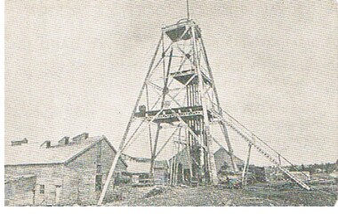
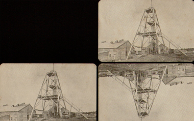
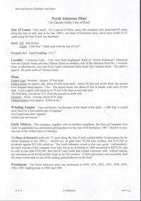
Photograph - EXTENDED HUSTLERS FREEHOLD
black and white photograph of Great Extended Hustlers Freehold poppet head, now at Wattle Gully, Chewton ( james Lerk 26.22.1999 ) Poppet head in front of mining buildings, stacks of sawn timber tonight. Great Extended Hustlers/locality/Hustlers Hill Nth. Bendigo/ formed 1865/last production 1921. Depth of shaft 3,470 ( 1045 m ) Poppet legs, steel 70 feet high ( 21.08 ) Gold very rich, total yield 300,000 ozs. Dividends 675,000 pounds sterling ( $1,350,000 )organization, business, great extended hustlers mine -
 Kew Historical Society Inc
Plan - Camberwell Panorama Estate, 1923
Subdivision plans and real estate flyers/brochures reveal a number of aspects of urban development and history. The Kew Historical Society's collection of these plans, as well as advertisements extracted from magazines, cover key aspects of community development and architectural history of Kew and Kew Eat as well as surrounding suburbs. While most of the plans in the collection were gifted to the Society by the former City of Kew, a number of other plans and advertisements have been donated by individuals, of which this is an example.Promotional brochure for the Camberwell Panorama Estate. The four page bifold handout advertises 216 home sites bounded by Bulleen Road, The Nook, Fortuna Avenue, and Doncaster Road. Other streets in the subdivision include: Sunburst Avenue, The Moor, and Macedon Avenue. The brochure has been damaged at some time in the past and so masking tape obscures the tram on page 1. Page 2 includes the plan of the subdivision, page 3 information about the site and a locality plan, while page 4 includes photographs and terms of sale. subdivision plans -- balwyn north (vic.), camberwell panorama estate -
 Ringwood and District Historical Society
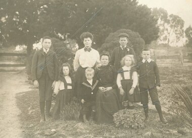
Photograph, Mrs Sherburn and family in garden in front of cottage, Ringwood, late 1800's
Black and white photograph (2 copies- one original mounted on cardboard backing, and one copy)Image shows Mrs Sherburn with 7 children in garden. Mr Charles Sherburn came to Australia as a widower who left a grown- up family in England, but married Polly Claridge and had another 10 children. Charles and Polly formed one of the early 'Bands of Hope' and went about the locality preaching Methodism. (Refer book 'Place of Many Eagles). -
 Flagstaff Hill Maritime Museum and Village
Book, Wool Wool Cookery Book
The book belonged to Mrs Bessie Neil, a daughter of Mr and Mrs William McKenzie who came from Scotland, possibly in the 1860s, and were employed at Glenample station, near Port Campbell. In about 1905, the Neills moved to South Africa, and the cookery book went with them. Recently Mrs Roger Pearce, formerly Lorraine Snell, who is married to a great grandson of Bessie Neill, thought it fitting that the book should be returned to this locality, and sent it to her mother, Mrs Mary Snell. Wool Wool Cookery Book Publisher F W Cheshire Printed in Camperdown by the Camperdown Chronicle 1903 inside cover has hand writting Bessie Keill, "Merkeering" (W), 27 Browning Street, Moonee Ponds. March 16th 04 flagstaff hill, warrnambool, shipwrecked-coast, flagstaff-hill, flagstaff-hill-maritime-museum, maritime-museum, shipwreck-coast, flagstaff-hill-maritime-village, wool wool cookery book, book, glenample homestead -
 Frankston RSL Sub Branch
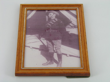
Photograph, Ron Gage, Generic frame
Details from World War 2 Nominal Roll GAGE, RONALD WILLIAM Service Australian Army Service Number VX107470 (V32070) Date of Birth 29 Aug 1921 Place of Birth MELBOURNE, VIC Date of Enlistment 16 Sep 1942 Locality on Enlistment GLENHUNTLY, VIC Place of Enlistment IN THE FIELD, QLD Next of Kin GAGE, FREDERICK Date of Discharge 31 Jul 1946 Rank Private Posting at Discharge 115 HEIDLEBERG MILITARY HOSPITAL Framed photograph, of serviceman Ron Gage, in uniform of the Australian Militia Horse Artillery ca 1936. The frame is of a light brown wood with silver trim and has a glass front.Label on the obverse; PRESENTED BY RON GAGE MILITIA ARTILLERY (HORSE) 1936 SELF PHOTOGRAPHron gage, -
 Bendigo Historical Society Inc.
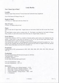
Photograph - GREAT EXTENDED HUSTLERS
Black and white postcards showing Great Extended Hustlers poppet head in foreground. Timber buildings, stacks of timber in background. Three copies of loose postcards. Inscriptions: 'Royal Historical Society of Victoria, Bendigo Branch, Great Extended Hustlers. Locality, Hustlers Hill, Nth. Bendigo. Formed 1865 - last production 1921. Depth of shaft - 3,470 feet. Poppet legs - steel, 70 feet high. Winding Engine: first motion, 8ft. Drums. Gold Very Rich, Total yield - 3000,000 ozs. Dividends L675,000.cottage, miners -
 Bendigo Historical Society Inc.
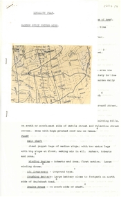
Document - LADY BARKLY MINE - NOTES ON THE LADY BARKLY MINE
One hand written and four typed copies of notes on the Lady Barkly Mine on the New Chum Line of Reef. Hand written copy has a small hand drawn locality map and a reference list attached. Notes include localilty, depth of shaft, size of lease, Plant. Battery was shared by The South St Mungo Mine, Early History, Prominence, Production and Reference. First year of production 1864 and last year of production 1907. One typed copy signed by A Richardson 29 Harrison St Bendigo. 4 typewritten copies not scanned.document, gold, lady barkly mine, lady barkly mine, st mungo group, snobs' hill, sadowa shaft, st mungo shaft, lady barkly, special edition aust. mining standard 1/6/99, mines dept booklet 'bendigo goldfield 1936, mines dept annual and quarterly reports, annalso fbendigo mining section 1880 - 1908, a richardson, kilfoy and co, robbins & co, ringale and north devonshire cos -
 Bendigo Historical Society Inc.
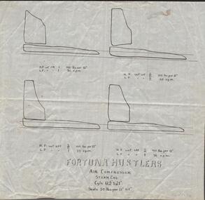
Document - FORTUNA COLLECTION: FORTUNA HUSTLERS - NOTES ON THE FORTUNA HUSTLERS
Four copies, 1 hand written and 3 typed copies of notes on the Fortuna Hustlers Mine. Notes include depth of shaft, size of lease, locality, plant, other mines where the winding engine worked, prominence, best reefs, total production. References: Mines Dept Special Edition 'Australian Mining Standard' 1/6/1899; Mines Dept Booklet 'Bendigo Goldfield' Geo Brown 1936; Mines Dept Booklet No 33 H. Herman 1914; 'Annals of Bendigo' (Mining Sections, From 1888 - 1913): A. Richardson.mine, gold, fortuna hustlers, fortuna hustlers, hustlers line of reef, railway goods sheds, buckell & jeffrey's, roberts & sons, tambour major, birds reef, hercules no 1, north virginia mine, gold production & dividends, australian mining standard (special edition) 1/6/1899, mines dept booklet 'bendigo goldfields' 1936, mines dept bulletin no 33, h herman 1914, annals of bendigo mining section 1888 - 1913, a richardson -
Bendigo Historical Society Inc.
Photograph - WINIFRED JENNINGS COLLECTION: MONIER BRIDGE, 1902
A photograph of Weerona Avenue's Monier Bridge testing failure in 1902. Here is a description from engineers australia.org detailing the bridges in Bendigo: "The 8 bridges in Bendigo represent the centre group of the 18 bridges built by Monash & Anderson under the Monier patents. The first group consisted of the two multi-span bridges at Fyansford and Wheelers Bridge in 1900. The eight Bendigo Bridges were built close together between 1901 and 1902. A further 7 Monier arch bridges were built at various other localities by Monash & Anderson during the period 1901 to 1913. "bendigo, history, early bendigo, weerona avenue, construction, incident. -
Bendigo Historical Society Inc.
Document - VICTORIA HILL - VICTORIA HILL IRONBARK
Typed copy of notes on Victoria Hill, Ironbark and New Chum Hill - An Historic Landmark. Notes include locality, some of the early mines, their depth, gold produced, dividends paid, vertical winding engine and crushing battery. Mines mentioned are: Rae's, Wittscheibe and Company 'Jeweller's Shop', the Advance, Cinderella Mine, Lansell's 180, North Old Chum, Victoria Quartz, Burrowes and Sterry's, Lazarus' Claim, Gibbs and Lazarus, Bonatti's, Menzies, Hildebrandt and Kock's, Ellesmere, Old Chum, New Chum and Victoria, New Chum United, New Chum Consolidated and the Garibaldi.document, gold, victoria hill, victoria hill, victoria hill ironbark, rae's, wittscheibe and company 'jeweller's shop', hopetoun band room, advance, cinderella mine, geo lansell, lansell's 180, new chum hill, fortuna mansion, new chum drainage association, north old chum, b c v 8 television studio, royal survey regiment, burrowes and sterry, lazarus claim, gibbs and lazarus, bonatti's, menzies, hildebrandt and kock's, ellesmere, old chum, p m g repeater station, ballerstedt, mr geo lansell, new chum and victoria, phoenix, mt alvernia hospital, new chum united, new chum consolidated, garibaldi, mr clarke magee -
 Ballarat Tramway Museum
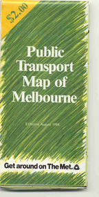
Map, Ministry of Transport and The Met, "Public Transport Map of Melbourne" - "Effective August 1988", 1988
Map - Pocket size - folded - public transport map of Melbourne, printed in colour on art paper, showing public transport services in greater Melbourne, an index of localities. The City Saver area shown in detail. On the rear, route numbers, line maps of tram routes, train lines, outer metropolitan services, ticketing information, Transport Neighbourhoods, . Shows the St Kilda and Port Melbourne light rail lines. Price $2. Shows "The Met" logo. On front under The Met logo and above the scale bar is "Effective 1/7/1988". Niltrams, tramways, melbourne, map, routes -
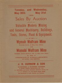 Bendigo Historical Society Inc.
Document - IAN DYETT COLLECTION: AUCTION CATALOGUE - WYMAH WOLFRAM MINE & WOMOBI WOLFRAM MINE
Two greyish covered catalogues for an auction of Modern Mining and General Machinery, Buildings, Tools, Stores, Plant & Equipment held on the 30th May 1944 at the Wymah Wolfram Mine, Wymah, N.S.W., and on the 31st May at the Womobi Wolfram Mine, Womobi (near Granya) Vic. Sales by Order of Commonwealth of Australia - Department of Supply and Shipping. Catalogue gives the locality of the two mines. Sale conducted by permission of the Director of Machine Tools and Gauges under the Regulation 59 of the National Security (General) Regulations. J. H. Curnow & Son were the auctioneers.business, auctioneers, j h curnow & son pty ltd, ian dyett collection - auction catalogue - wymah wolfram mine & womobi wolfram mine, commonwealth of australia-department of supply and shipping, j l jamieson, the cambridge press -
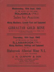 Bendigo Historical Society Inc.
Document - IAN DYETT COLLECTION: AUCTION CATALOGUE - GIBRALTAR GOLD MINE
Two red covered catalogues for an auction of Mining Machinery, Cyanide Plant and Equipment held on the 15th September 1943 at the Gibraltar Gold Mine at Majorca, Vic. Sale by Order of Frank Cooper & Co. Also on 16th September 1943 a sale of Mining Machinery, Buildings and Equipment of the Illabarook Alluvial Mine N. L. By Order of the Mines Department. Catalogue gives the locality of the two mines. Sale conducted by permission of the Director of Machine Tools and Gauges under the Regulation 59 of the National Security (General) Regulations. J. H. Curnow & Son were the auctioneers.business, auctioneers, j h curnow & son pty ltd, ian dyett collection - auction catalogue - gibraltar gold mine, frank cooper & co, mines department, j h curnow & son, j l jamieson, regulation 59 of the national security (general) regulation, illabarook alluvial mine n l, the cambridge press -
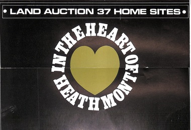 Ringwood and District Historical Society
Pamphlet, Land Auction Brochure - Heathmont Hills Estate, Heathmont, Vic
Multi-fold brochure advertising auction of 37 home sites on Saturday May 6th, (1967?). Brochure includes terms of sale, description of subdivision features and local facilities, with locality map. Subdivision includes Canterbury Road, Cuthbert Street, and Craig Court, off Balfour Avenue, Heathmont. Agent - N.R. Reid & Co Pty Ltd., 173 Coleman Parade, Glen Waverley, (phone) 560 0355 A.H. 28 3185, in conjunction with H.G. McLean Pty Ltd., 166 Canterbury Road, Heathmont, 87 7808 A.H. 842 2708. -
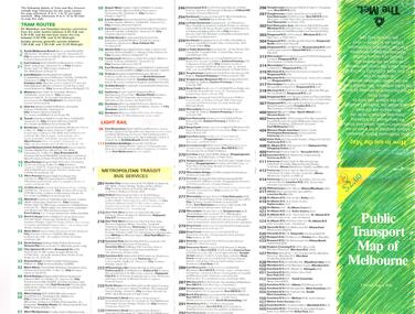 Melbourne Tram Museum
Map, The Met, "Public Transport Map of Melbourne" - "Effective August 1988", 1988
Map - Pocket size - folded - public transport map of Melbourne, printed in colour on art paper, showing public transport services in greater Melbourne, an index of localities. The City Saver area shown in detail. On the rear, route numbers, line maps of tram routes, train lines, outer metropolitan services, ticketing information, Transport Neighbourhoods, . Shows the St Kilda and Port Melbourne light rail lines. Price $2. Shows "The Met" logo. On front under The Met logo and above the scale bar is "Effective 1/7/1988".In ink in top left hand corner, "11" in a circle.trams, tramways, melbourne, map, routes -
 Bendigo Historical Society Inc.
Document - NORTH JOHNSONS MINE - NOTES ON THE NORTH JOHNSONS MINE
One typed, one handwritten and one handwritten carbon copy of notes on the North Johnsons Mine on the Garden Gully Line of Reef. Notes include size of lease (which was very small, only 83 yards along the line of reef, and the late 1890's absorbed the Rose of Denmark lease, the next mine north, of 57 yeards along the line of reef, Depth of shaft, height of Sill, Locality, Plant, Early History, Prominence, Best Gold, Total Gold Yield and Dividends,Underground Connections and References. Albert Richardson Collection. document, gold, north johnsons mine, north johnsons mine, garden gully line of reef, rose of denmark, camerons reef, dagmar reef, johnsons no 1, johnsons no 2, special edition australian mining standard 1/6/1899, mines dept booklet bendigo goldfield geo brown 1936, mines dept quarterly and annual reports, annals of bendigo mining sections 1866 - 1917, a richardson, e j dunn's special report no 1 measurements taken from north johnsons mine transverse section 22/9/1892, wood & mcnair sharebrokers plan of leases of portion of bendigo goldfield to 4/5/1912 -
 Bendigo Historical Society Inc.
Document - ALBERT RICHARDSON COLLECTION: GARDEN GULLY UNITED MINE
Three-page typed document plus map showing location of the Garden Gully United Mine. The history and features of the mine operation are described and include: the locality of the shafts, winding engine, air compressor, crushing battery, engine house, gold obtained and dividends and gold production. The lookout tower in Rosalind Park was formerly the poppet legs of the Garden Gully United Gold Mining Company. Albert Richardson writes: ' a fitting tribute to Bendigo's most famous goldmine. The four-legged lookout tower was originally the six-legged poppet legs of the Garden Gully United.bendigo, mining, garden gully united mine, gold mining, poppet legs, rosalind park -
 Warrnambool and District Historical Society Inc.
Film - Directory : microfiche, Wise's Post Office Directory Victoria, Original directories 1890's. Microfiche circa 1980's
These directories provide information on localities and surnames, services and trade information throughout Victoria. Included in this folder are the following: Wise’s Victoria Post Office Directory 1884-85 Wise’s Victoria Post Office Directory 1888-89 Wise’s Victoria Post Office Directory 1891-92 Wise’s Victoria Post Office Directory1893-94 Wise’s Victoria Post Office Directory 1895-96 Wise’s Victoria Post Office Directory 1897-98 Wise’s Victoria Post Office Directory 1899-00 This directory is a useful resource in researching people and towns of the given areaRed plastic folder with white printed label attached to front cover. Contains smaller card index inserts. Four plastic sleeves containing microfiche. Ref 929.3945 Aus/Nif written in black pen inside front cover wise’s victoria post office directory 1884-85, wise’s victoria post office directory 1888-89, wise’s victoria post office directory 1891-92, wise’s victoria post office directory1893-94, warrnambool history -
 Bacchus Marsh & District Historical Society
Map, Allotments in the Village of Rowsley, Parish of Gorrocburkghap, County of Grant c.1856
Rowsley is a locality 11 kilometers south-west of Bacchus Marsh. The date of this map is uncertain. A very similar map held by the State Library of Victoria (SLV) contains slightly more information than this copy and is dated as an 1856 map. SLV reference: 'Allotments in the Village of Rowsley, Parish of Gorrocburkghap, County of Grant', by T. Nixon, Assistant Surveyor, May 1856 ; Surveyor General’s Office, July 18 1856 (lithographed by R. Meikle). (1856). Melbourne: Surveyor General’s Office. MAPS 820 BJE 1837- ROWSLEY 1856. A single page paper map. A cadastral map of the Village of Rowsley in Victoria, showing numbered land allotments. 57 allotments are shown on the map and some areas set aside as reserves. Allotments 8, and 10-16 are outlined in red ink and allotment 9 has a cross in red ink on it. The map is pasted into a bound volume containing 76 maps or plans in total. High resolution digital image stored on BMDHS computer network. rowsley victoria history, rowsley victoria maps -
 Bacchus Marsh & District Historical Society
Map, Maddingley Township, Parish of Parwan, circa 1890s
Maddingley is a locality or township within the broader township area of Bacchus Marsh. This map is not dated. However features in Maddingley which appeared in the 1880s and 1890s are present in the map, These include the Bacchus Marsh Railway Station and the Bacchus Marsh Showgrounds. The main residential and commercial area of Maddingley is shown on this map in an area bounded by Bacchus Street, Barry Street, Griffith Street and Maddingley Road. Other streets visible are Franklin Street, Inglis Street, Labilliere Street, McCrae Street, Moore Street and part of Station Street.A single page paper map showing land allotments, streets, rivers, creeks, park lands, the railway line and Bacchus Marsh railway station in the township of Maddingley. The map is pasted into a bound volume containing 76 maps or plans in total. bacchus marsh victoria maps, maddingley victoria maps, land use, maddingley victoria history -
 Warrnambool and District Historical Society Inc.
Book, Road register loose binder, 1953
This is an Alphabetical Register of the streets in Warrnambool as listed by Warrnambool City Council officers. It appears to have been a working register used in the 1950s, 60s and 70s and information has been added to the entries as it became available and as Council works were carried out in these streets. It contains information on the locality, wards, allotment numbers, lodged plan numbers, footpaths and printed information from the Victorian Local Government Departments. It sometimes gives the origin of the name of the street and some other miscellaneous information is included. It is presumed that the information contained therein has now been stored electronically. This is a most important ledger as it contains much valuable historical information on Warrnambool streets. It will be of great use to researchers. This is a loose leaf binder with a black leather cover and a black metal and cord binding mechanism. The pages are unnumbered but there is provision for insertion or removal of pages and there are leather alphabetical tabs protruding from the pages. The pages have blue ruled lines with blue lined margins and headings. The streets in Warrnambool are listed alphabetically and the information in the register contains both typed and handwritten material. There are also printed notices from the Victorian Local Government department, extracts from newspapers, copies of letters and plans of street subdivisions. There is one loose page.warrnambool city council, warrnmbool streets register -
 Kiewa Valley Historical Society
Maps, Unknown
There are 2 maps: 1. Broadbent's Makers of Maps since 1896, No. 323 Across the Alps/Official Copyright Map./ The cover is blue, green and orange with advertising for Ólympic' and 'Bosch' and there is further advertising on the fold out covers/ 2/-. 2. Robinson's Kiewa Hydro-Electric Scheme & Hotham Heights Map No. 613, with Insets of: Bright, Mt Beauty, Falls Creek Ski Village, Hotham Heights Ski Village/ the cover is blue, green and orange with image of skier, hydro tower and locality map./Other fold out sides have advertising and information for tourists./ 4/-.maps, tourism, kiewa hydro electric scheme, victorian alps, skiing -
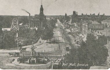 Bendigo Historical Society Inc.
Postcard - BLACK AND WHITE PHOTO OF PALL MALL BENDIGO: EARLY DAYS TO LATE 1800'S
Black and white Photo of Pall Mall Bendigo - early days - late 1800's - postcard -rear of card shows Royal Historical Society of Victoria Bendigo Branch - Hustlers Royal Reserve No.2 Locality; Pall Mall Bendigo RSL Memorial Hall now occupies site. Depth of shaft -1,660 feet, Formed 1885, closed 1917, Poppet legs - steel, 60 feet high. Winding engine: First motion, 24 in. Cylinders, 10ft. Drums. Gold Yield - 10,262 ozs .Dividends 3,200 pounds. / Photo shows Beehive sign.postcard, photograph, bendigo, pall mall bendigo - early days - late 1800's /--hustlers royal reserve no.2 locaility ; pall mall bendigo rsl memorial hall / beehive sign -
Bendigo Historical Society Inc.
Document - NEW CHUM LINE OF REEF - LEASE SANDHURST NO 100 NEW CHUM COMPANY
Handwritten page of notes on the New Chum Company, Lease Sandhurst No 100. Notes give period of lease, locality, nature of lease and area of lease. In 1863 there was a disagreement with neighbouring leases. By 22/10/1866 Leases 81, 100.113.306,424,425 & 872 were surendered and R Schlesinger on behalf of New Chum Co was granted a new lease in their place. Item 7 Lease details, Edward Hunt & Anthony Stephens, Lease holders Application lodged 13/8/1859 No 134. Date 5/3/1860 for a term of ten years. Reference; Lease Book, Mines Department.document, gold, new chum line of reef, new chum line of reef, lease sandhurst no 100 new chum company, d mcdougall, menzies claim, r schlesinger, edward hunt, anthony stephens, lease book mines dept -
 Bendigo Historical Society Inc.
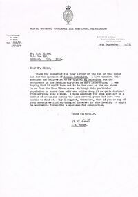
Document - PETER ELLIS COLLECTION: LETTER, 24th September, 1973
Letter, dated 24th September, 1973, to Mr P N Ellis from A B Court of the Royal Botanic Gardens and National Herbarium. In the A B Court thanks Mr Ellis for his letter and for the specimen of Acacia hakeoides. He was hoping it would turn out to be the same as the one known to him from the Moon Mines area. He had searched for this species? During the last several years but had been unable to find it. He suggest that if Mr Ellis or his associates find anything of interest in the locality it might be worthwhile forwarding a specimen for examination. Signed A B Court.communication, postal, letters, peter ellis collection, department of crown lands and survey victoria, royal botanic gardens and national herbarium, p n ellis, moon mines area, a b court -
Kew Historical Society Inc
Plan - Saxonwood Estate, Doncaster [East]
Subdivision plans and real estate flyers/brochures reveal a number of aspects of urban development and history. The Kew Historical Society's collection of these plans, as well as advertisements extracted from magazines, cover key aspects of community development and architectural history of Kew and Kew Eat as well as surrounding suburbs. While most of the plans in the collection were gifted to the Society by the former City of Kew, a number of other plans and advertisements have been donated by individuals, of which this is an example.Undated, multi-page subdivision plan advertising lots for sale bounded by Blackburn Road, George Street, Windermere Avenue, and Saxonwood Drive in what is currently Doncaster East. Other streets in the subdivision include: Mowbray Court, Stafford Court, Rugby Court, and Robin Hood Court. The front page includes a Birdseye view of the estate which identifies existing and projected civic amenities, as well as the estate's relationship to surrounding suburbs and the city centre. Red crosses on the detailed plan of lots on page two indicate those that have been sold. The final page includes a locality plan. saxonwood estate -- doncaster east (vic.), subdivision plans -- doncaster east (vic.) -
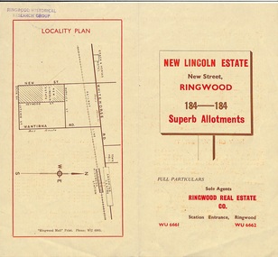 Ringwood and District Historical Society
Document - Folder, Land Sale Brochure, New Lincoln Estate, Ringwood, Vic. - circa 1960. Also 1951 newspaper advertisement
Bi-fold advertisement for sale of residential allotments - New Lincoln Estate, New Street, Ringwood, with summary of local facilities and services, locality plan, layout of sub-division, and price list. Also an advertisement from Ringwood Mail dated 12 July 1951. Subdivision includes New Street, Heywood Street, Barkly Street, Keith Grove, Maurice Avenue, Inez Avenue, Catherine Street, Neville Street, Neale Grove (later Heather Grove), and Sylvia Grove. Agent - Ringwood Real Estate Co., Station Entrance, Ringwood. (Phone) WU 6661, WU 6662.Accompanying handwritten sales notes researched in 2024 by Richard Carter - Carter Real Estate ... "Maurice Ashkanasy KC CMG owned the rectangular estate located between New, Barkly, Heywood Streets and Sylvia Grove in South-West Ringwood. It was given the name "The New Lincoln Estate". It was first advertised around July 1951 as "48 superb allotments", through Ringwood Real Estate (Station Entrance). A sub-divisional plan from CE Carter showed 152 blocks with 60-foot frontages and varying between 110 and 150 feet in length. Later, in 1954 house and land packages were offered through William White in Elsternwick - "Three modern bedrooms, large lounge-dining-room, kitchen with dinette, nicely equipped bathroom - £2,685 to £2,762, deposit £300". The roads were created and named after family members - Neale (later Heather) Grove - after Maurice's son Neal Mark Ashkanasy. The street was later re-named Heather Grove after Maurice's wife, Heather Helen Ashkanasy (Epstein), who passed away in 1999, aged 95. Neville Street - after Marice's other son, Aaron Solomon Neville Ashkanasy known as Neville. Catherine Street and Inez Street - after Heather's mother Catherine Inez Epstein. Maurice Avenue - after Maurice Ashkanasy, vendor. Keith Grove - after Keith Epstein. ..." -
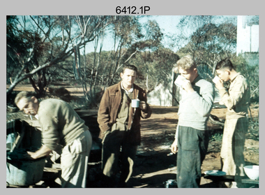 Bendigo Military Museum
Photograph - Royal Australian Survey Corps Surveyors in the Field – Victoria, 1956 - 1958
This is a set of two photographs of surveyors and support staff in the field undertaking tasks in Victoria 1956 – 1958. The surveyors were employed in the establishment of mapping and geodetic control. In this era surveyors used theodolites to observe horizontal and vertical angles and chains to measure base line distances between survey stations. This is a set of 23 photographs of surveyors and support staff in the field undertaking duties in Victoria 1956 – 1958. The photographs were printed on photographic paper and are part of the Army Survey Regiment’s Collection. The photographs were scanned at 300 dpi. .1) - Photo, colour, 1956. Surveyors enjoying a tea break. L to R: Tom Gilbert (cook), Barry Broad, Tony Slattery, John Van De Graff. Taken at Boonoonar, a locality south of Mildura. .2) - Photo, colour, 1958. Surveyors taking a break from driving. L to R: Leo Bub, Bob Thompson. Taken at Puckapunyal..1P to .2P annotated on back – personnel names, the year and the location. royal australian survey corps, rasvy, army survey regiment, asr, army svy regt, fortuna, surveying -
 Bendigo Historical Society Inc.
Document - OLD CHUM MINE - NOTES ON THE OLD CHUM MINE
Handwritten notes on the Old Chum Co. Ref. M. D. Early History of Old Chum & The Old Chum Coy. Notes mention the popularity and locality of the mine. The shaft being well timbered. List of dates, tons of ore and the ounces of gold obtained from it, Dividends paid, Mine worked by steam. Engine 18 H. P. 13 in dia cylinders. No pumps, mine perfectly dry. No crushing battery. Mine crushed at Endeavour and the 'Fortuna'. Keeping 3 batteries going altogether. Mine registered 16/6/1871. Notes prepared by Albert Richardson.document, gold, old chum mine, old chum mine, notes on the old chum mine, endeavour, fortuna, m d early history of old chum & the old chum coy -
 Warrnambool and District Historical Society Inc.
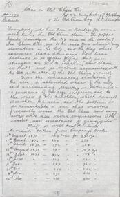
Book - Hospital Auxiliary Minute Book, Secretary of Allans Forest Red Cross Hospital Auxiliary, 1925-1930
This book contains the Minutes and financial details from the Allans Forest Red Cross Hospital Auxiliary from 1925 to 1930. Allans Forest is a small locality on the Great Ocean Road about three kilometres from the township of Allansford on the eastern fringe of Warrnambool. The Hospital Auxiliary was formed as an extension of the Allansford group in 1925 to provide support for the Warrnambool and District Hospital. The group raised funds with dances and jumble sales and donated to the hospital such items as groceries (especially home made jams and soaps), hospital linen and baby wear. The hospital would provide tins of fat for the ladies to make the soap. This exercise book is of interest as a memento of the activities of a small group in a small settlement in the Warrnambool area nearly a hundred years ago. It shows the reliance in the past of a town hospital on local groups to provide basic items such as food and linen.This is an exercise book with a dark red cardboard cover and black binding on the spine. The pages have ruled black lines and handwritten entries in ink. Some pages are blank.Allan's Forest Red Cross Hospital Auxiliaryallans forest, warrnambool and district hospital, allans forest red cross