Showing 346 items
matching municipal history
-
 Kew Historical Society Inc
Journal, The Kewriosity Sheet Vol.4 No.2 : September 1982
Studley Park Ward Councillors - Cr J. Tutt, Cr R. Sanders, Cr J. O'Brien [City of Kew; Political profiles/ p1. Stolen [instruments; Kew Philharmonic Society] / p1. Deafness Awareness Week / p2. Mediate at home / p2. I.E.C.D. [Short courses; Institute of Early Childhood Development] / p2. What's doing in Kew for September / p2. Native Plant Group / p2. Kew Garden Club / p2. Family & Community Services Programme (F.A.C.S.) [Community Service Grants] / p3. Kew Philharmonic Orchestra / p3. Drop In [Kew Uniting Church] / p3. Come Alive! / p3. Good news for craft workers [Worco Recyclotron] / p3. Caregivers needed [Family Day Care] / p3. Kew Municipal Library / p3. Moderator to visit [Moderator of the Synod of Victoria] / p3. Highbury Grove Kew Uniting Church - History of Church [former Kew Methodist Church] / p4. Centenary concert [Kew Uniting Church] / p4. Mission Spring Fair [Missionary Sisters of St Peter Claver] / p4. Hyde Park Fellowship [Hyde Park Uniting Church] / p4. Uniting Church East Kew / p4.The Kewriosity Sheet (1979-83) was first published in the City of Kew (Victoria) in June 1979 as a two-sided 'community newssheet'. It aimed to: 'share news about Kew happenings and Kew people, and to exchange ideas about living in Kew'. Later issues gradually evolved into a 4-page, quarto sized publication. The Kewriosity Sheet was superseded by the Kew Council publication 'Kewriosity' (1983-1994).non-fictionStudley Park Ward Councillors - Cr J. Tutt, Cr R. Sanders, Cr J. O'Brien [City of Kew; Political profiles/ p1. Stolen [instruments; Kew Philharmonic Society] / p1. Deafness Awareness Week / p2. Mediate at home / p2. I.E.C.D. [Short courses; Institute of Early Childhood Development] / p2. What's doing in Kew for September / p2. Native Plant Group / p2. Kew Garden Club / p2. Family & Community Services Programme (F.A.C.S.) [Community Service Grants] / p3. Kew Philharmonic Orchestra / p3. Drop In [Kew Uniting Church] / p3. Come Alive! / p3. Good news for craft workers [Worco Recyclotron] / p3. Caregivers needed [Family Day Care] / p3. Kew Municipal Library / p3. Moderator to visit [Moderator of the Synod of Victoria] / p3. Highbury Grove Kew Uniting Church - History of Church [former Kew Methodist Church] / p4. Centenary concert [Kew Uniting Church] / p4. Mission Spring Fair [Missionary Sisters of St Peter Claver] / p4. Hyde Park Fellowship [Hyde Park Uniting Church] / p4. Uniting Church East Kew / p4. community publications --- kew (vic.), the kewriosity sheet, newsletters - kew (vic.) -
Kew Historical Society Inc
Journal, Kew Historical Society, Newsletter No.144, September 2023
Elephants in Kew [Kew Library redevelopment] / David White p1. History News - 2023 Dickinson Lecture; Kew Court House [exhibition]; Additions to the Collection; New members; Grants & Sponsors / p3. Victorian Municipal Directories / Robert Baker p4. Michael Meszaros: Kew sculptor / Felicity Renowden p6. Chipperfield's Boathouse: 'The Moorings' and floating pontoon / Julie King p8. Wilfred Kent Hughes: scholar, sportsman, soldier, businessman, author, politician / John Torpey p10.Published quarterly since 1977, the newsletters of the Kew Historical Society contain significant research by members exploring relevant aspects of the Victorian and Australian Framework of Historical Themes. Frequently, articles on people, places and artefacts are the only source of information about an aspect of Kew, and Melbourne’s history.non-fictionElephants in Kew [Kew Library redevelopment] / David White p1. History News - 2023 Dickinson Lecture; Kew Court House [exhibition]; Additions to the Collection; New members; Grants & Sponsors / p3. Victorian Municipal Directories / Robert Baker p4. Michael Meszaros: Kew sculptor / Felicity Renowden p6. Chipperfield's Boathouse: 'The Moorings' and floating pontoon / Julie King p8. Wilfred Kent Hughes: scholar, sportsman, soldier, businessman, author, politician / John Torpey p10.kew historical society (vic.) -- periodicals., kew historical society (vic.) -- newsletters, kew historical society (vic.) -- journals -
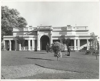 Kew Historical Society Inc
Photograph - 'Southesk', Cotham Road, c. 1965
Ordsall (c.1864-1970) - Situated on the southwest corner of Cotham Road and Charles Street, the single-storey Italianate mansion, Ordsall, was built for John Halfey in the 1860s. Following extensions in 1878 and 1881to designs by Michael Hennessy, Halfey commissioned the decorating firm of Cullis Hill & Co to create elaborate coloured frescoes on the ceilings of the drawingroom and ballroom in 1882. These frescoes were among the finest created in Melbourne during this period. Sold in 1905 to David Carnegie, and renamed South Esk, it was sold to the City of Kew in 1947 and demolished in 1970.This work forms part of the collection assembled by the historian Dorothy Rogers, that was donated to the Kew Historical Society by her son John Rogers in 2015. The manuscripts, photographs, maps, and documents were sourced by her from both family and local collections or produced as references for her print publications. Many were directly used by Rogers in writing ‘Lovely Old Homes of Kew’ (1961) and 'A History of Kew' (1973), or the numerous articles on local history that she produced for suburban newspapers. Most of the photographs in the collection include detailed annotations in her hand. The Rogers Collection provides a comprehensive insight into the working habits of a historian in the 1960s and 1970s. Together it forms the largest privately-donated collection within the archives of the Kew Historical Society.The front garden and facade of South Esk in Cotham Road, Kew, during the period when it was owned by the City of Kew. The mansion was demolished by the City in 1970."2. Chap 22 Southesk . Ordsall John Halfey. Orig. part to 1858. Additional about 1862. Southesk once Ordsall . Demolished to make way for Municipal Chambers. Commenced approx. 1858 added front by John Halfey 1862."south esk, ordsall, david carnegie, kew city council, cotham road (kew), dorothy rogers, john halfey -
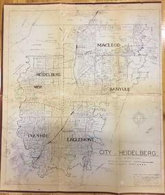 Kew Historical Society Inc
Plan, City Engineers Department (Heidelberg), City of Heidelberg Plan: Scale 20 chns to 1 inch, 1970-1993
Gwen Barton McWilliam (nee: Nelson), OAM, BA (1933- ). Gwen McWilliam is well known as an authority on the history of Boroondara and the author of a large number of books and pamphlets about the City. She was awarded the medal of the Order of Australia in 2001 ‘for service to the community of Hawthorn and district, particularly through the research, documentation and publication of its history.’ Primary source annotated by a distinguished local historian.Plan of number of areas in the City of Heidelberg showing municipal and ward boundaries, subsequently annotated by the historian Gwen McWilliam, identifying significant landholdings, subdivisions and key dates.The base map was printed in 1970 and annotated c.1993. The plan was donated to the Kew Historical Society by Gwen McWilliam. Handwritten annotations by Gwen McWilliam, 1993city of heidelberg, maps -- heidelberg (vic.), gwen mcwilliam -
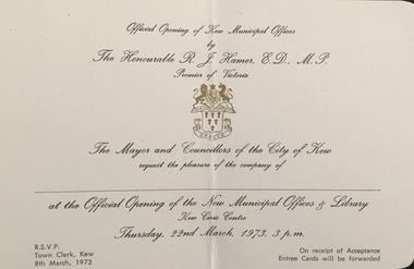 Kew Historical Society Inc
Document (item) - Invitation, City of Kew, Official Opening of Kew Municipal Offices, 1973
The Municipality of Kew (1860-1863), the Borough of Kew (1863-1910), the Town of Kew (1910-1921) and the City of Kew (1921-1994) were local government instrumentalities in the State of Victoria. In 1994, the City of Kew was amalgamated, together with the former Cities of Camberwell and Hawthorn, into the new City of Boroondara (1994- ). Like other local government entities of the period, Kew was administered by town clerks. The two notable town clerks in Kew's history were H. H. (Henry Hirst) Harrison (1868-1955) and W. D. (William Dickie) Birrell (1899-1974). Harrison was appointed to the position in 1901 and retired in 1938 after 37 years. Birrell, appointed Acting Town Clerk in 1921, became Town Clerk in 1938, following Harrison's retirement. He continued in this role until his retirement in 1966.This card is part of an historically significant civic collection, containing hundreds of separate invitations, documents, greeting cards, programmes and tickets issued and/or collected by successive town clerks. Items in the collection illuminate the political, social and cultural history of the district. As a continuous record, ranging across most decades of the Twentieth Century, they reveal changing tastes in design, values and relationships in the history of local government in Victoria.OFFICIAL OPENING OF KEW MUNICIPAL OFFICES / BY / THE HONOURABLE R J HAMER, PREMIER OF VICTORIA / THE MAYOR AND COUNCILLORS OF THE CITY OF KEW / REQUEST THE PLEASURE OF THE COMPANY OF / ___________ / OFFICIAL OPENING OF THE NEW MUNICIPAL OFFICES & LIBRARY / KEW CIVIC CENTRE / THURSDAY, 22ND MARCH, 1973, 3 P.M./ RSVP TOWN CLERK , KEW 8TH MARCH, 1973 / ON RECEIPT OF ACCEPTANCE ENTREE CARDS WILL BE FORWARDEDcivic invitations -- kew (vic), kew town hall -- charles street -- kew (vic.), kew civic offices -
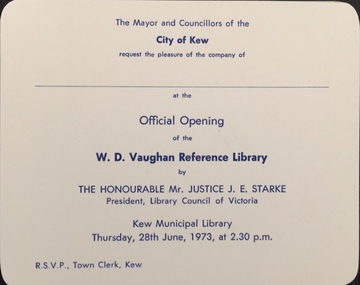 Kew Historical Society Inc
Document (item) - Invitation, City of Kew, Official Opening of the W D Vaughan Reference Library, 1973
The Municipality of Kew (1860-1863), the Borough of Kew (1863-1910), the Town of Kew (1910-1921) and the City of Kew (1921-1994) were local government instrumentalities in the State of Victoria. In 1994, the City of Kew was amalgamated, together with the former Cities of Camberwell and Hawthorn, into the new City of Boroondara (1994- ). Like other local government entities of the period, Kew was administered by town clerks. The two notable town clerks in Kew's history were H. H. (Henry Hirst) Harrison (1868-1955) and W. D. (William Dickie) Birrell (1899-1974). Harrison was appointed to the position in 1901 and retired in 1938 after 37 years. Birrell, appointed Acting Town Clerk in 1921, became Town Clerk in 1938, following Harrison's retirement. He continued in this role until his retirement in 1966.This card is part of an historically significant civic collection, containing hundreds of separate invitations, documents, greeting cards, programmes and tickets issued and/or collected by successive town clerks. Items in the collection illuminate the political, social and cultural history of the district. As a continuous record, ranging across most decades of the Twentieth Century, they reveal changing tastes in design, values and relationships in the history of local government in Victoria.THE MAYOR AND COUNCILLORS OF THE CITY OF KEW / REQUEST THE PLEASURE OF THE COMPANY OF / ________________________ / AT THE OFFICIAL OPENING OF THE W D VAUGHAN REFERENCE LIBRARY / BY / THE HONOURABLE MR JUSTICE J E. STARKE / PRESIDENT LIBRARY COUNCIL OF VICTORIA / KEW MUNICIPAL LIBRARY / THURSDAY 28TH JUNE, 1973, AT 2.30 P.M. / RSVP TOWN CLERK, KEWcivic invitations -- kew (vic), kew municipal library, w d vaughan -
 Kew Historical Society Inc
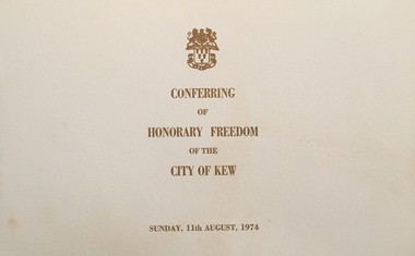
Document - Programme, City of Kew, Conferring of Honorary Freedom of the City of Kew, 1974
The Municipality of Kew (1860-1863), the Borough of Kew (1863-1910), the Town of Kew (1910-1921) and the City of Kew (1921-1994) were local government instrumentalities in the State of Victoria. In 1994, the City of Kew was amalgamated, together with the former Cities of Camberwell and Hawthorn, into the new City of Boroondara (1994- ). Like other local government entities of the period, Kew was administered by town clerks. The two notable town clerks in Kew's history were H. H. (Henry Hirst) Harrison (1868-1955) and W. D. (William Dickie) Birrell (1899-1974). Harrison was appointed to the position in 1901 and retired in 1938 after 37 years. Birrell, appointed Acting Town Clerk in 1921, became Town Clerk in 1938, following Harrison's retirement. He continued in this role until his retirement in 1966.This card is part of an historically significant civic collection, containing hundreds of separate invitations, documents, greeting cards, programmes and tickets issued and/or collected by successive town clerks. Items in the collection illuminate the political, social and cultural history of the district. As a continuous record, ranging across most decades of the Twentieth Century, they reveal changing tastes in design, values and relationships in the history of local government in Victoria.Multi-page programme given to attendees at the ceremony conferring the honorary freedom of the City of Kew on the Rt Hon R G Menziescivic invitations -- kew (vic), kew municipal library, w d vaughan -
Kew Historical Society Inc
Journal, Kew Historical Society, Newsletter No.124, September 2018
History & Heritage / Robert Baker p1. Society News p3. Kew Municipal Baths / David White p4. Kew East Heritage Gap Study / Brad Miles p6. Preserving Visual Evidence in Paintings / Robert Baker {with Don Garden, Lisa Worrell] p5. Performing & Visual Arts: the Vandersluys-Kelly Collection / Robert Baker p9. Notice of Annual General Meeting / Brad Miles p10. Form for Appointment of Proxy; Nomination form p11. Membership & Donations p12.Published quarterly since 1977, the newsletters of the Kew Historical Society contain significant research by members exploring relevant aspects of the Victorian and Australian Framework of Historical Themes. Frequently, articles on people, places and artefacts are the only source of information about an aspect of Kew, and Melbourne’s history.non-fictionHistory & Heritage / Robert Baker p1. Society News p3. Kew Municipal Baths / David White p4. Kew East Heritage Gap Study / Brad Miles p6. Preserving Visual Evidence in Paintings / Robert Baker {with Don Garden, Lisa Worrell] p5. Performing & Visual Arts: the Vandersluys-Kelly Collection / Robert Baker p9. Notice of Annual General Meeting / Brad Miles p10. Form for Appointment of Proxy; Nomination form p11. Membership & Donations p12.kew historical society (vic.) -- periodicals., kew historical society (vic.) -- newsletters, kew historical society (vic.) -- journals -
 Kew Historical Society Inc
Map, MMBW, MMBW Town of Kew, 1910-21
The Melbourne and Metropolitan Board of Works (MMBW) was established by an act of the Victorian Parliament in 1890 to prepare for and to implement a sewerage and water reticulation system across what was then inner Melbourne, its surrounding and middle distance suburbs, including Kew. The MMBW was disbanded in 1991.The map collection of the Kew Historical Society has at its core the historic maps assembled and originally stored in the City Engineer's Department of the City of Kew. These include maps in a number of scales. The vast majority of maps were produced by the MMBW in the first two decades of the twentieth century, and are solid working maps, backed by linen for durability. These maps are historically significant to Kew, the City of Boroondara and to the history of the development of state utilities in Victoria. A number of the Kew maps have additional details added by former municipal officers, including the levels reached by various floods. As these were working documents, information was added to them long after the period of their initial production and distribution.Early map of the Town of Kew, created after 1910, at a scale 440 ft to 1 inch. The 'assembled' map by the City of Kew Engineer's Department includes scaled down copies of The Melbourne and Metropolitan Board of Works maps, Nos. 39, 40, 64, 65, 66, 67, 68, and 117. The map covers the entirety of the Town of Kew, bordered on its north and west by the River Yarra, by Burke Road in the East and Barkers Road in the south. The map shows the extent of urban development by that time, prominent institutions and the outlines of built structures in the municipality. TOWN OF KEW / SCALE 400 FEET TO 1 INCHmelbourne & metropolitan board of works, mmbw maps, mmbw plans, town of kew, cartography -
 Kew Historical Society Inc
Map, MMBW, MMBW Plan No.39 Kew & Heidelberg, 1900-1910
The Melbourne and Metropolitan Board of Works (MMBW) was established by an act of the Victorian Parliament in 1890 to prepare for and to implement a sewerage and water reticulation system across what was then inner Melbourne, its surrounding and middle distance suburbs, including Kew. The MMBW was disbanded in 1991.The map collection of the Kew Historical Society has at its core the historic maps assembled and originally stored in the City Engineer's Department of the City of Kew. These include maps in a number of scales. The vast majority of maps were produced by the MMBW in the first two decades of the twentieth century, and are solid working maps, backed by linen for durability. These maps are historically significant to Kew, the City of Boroondara and to the history of the development of state utilities in Victoria. A number of the Kew maps have additional details added by former municipal officers, including the levels reached by various floods. As these were working documents, information was added to them long after the period of their initial production and distribution.Early map of part of the Borough of Kew, created in the first decade of the twentieth century, at a scale 160 ft to 1 inch. The map covers what was then the north western section of Kew, bordered on its north by Wills Street and the Kew Lunatic Asylum, in the west by the River Yarra [and the later added Yarra Boulevard] , by Princess Street in the East and Holroyd Street in the south. The map shows the extent of urban development by that time, prominent institutions and the outlines of built structures in the municipality. Contour lines were added in ink to the map at a later stage.MELBOURNE AND METROPOLITAN BOARD OF WORKS / PLAN NO. 39 / KEW & HEIDELBERGmelbourne & metropolitan board of works, mmbw maps, mmbw plans, borough of kew, cartography -
 Kew Historical Society Inc
Map, MMBW, MMBW Plan No.40 Collingwood & Kew, 1900-1910
The Melbourne and Metropolitan Board of Works (MMBW) was established by an act of the Victorian Parliament in 1890 to prepare for and to implement a sewerage and water reticulation system across what was then inner Melbourne, its surrounding and middle distance suburbs, including Kew. The MMBW was disbanded in 1991.The map collection of the Kew Historical Society has at its core the historic maps assembled and originally stored in the City Engineer's Department of the City of Kew. These include maps in a number of scales. The vast majority of maps were produced by the MMBW in the first two decades of the twentieth century, and are solid working maps, backed by linen for durability. These maps are historically significant to Kew, the City of Boroondara and to the history of the development of state utilities in Victoria. A number of the Kew maps have additional details added by former municipal officers, including the levels reached by various floods. As these were working documents, information was added to them long after the period of their initial production and distribution.Early map of part of the Borough of Kew, created in the first decade of the twentieth century, at a scale 160 ft to 1 inch. The map covers what was then the south western section of Kew, bordered on its north by Studley Park Road, in the west by Walmer Street and the River Yarra, by High Street South and Princess Street in the East and Barkers Road in the south. The map shows the extent of urban development by that time, prominent institutions and the outlines of built structures in the municipality. Contour lines and historic flood levels were added in ink to the map at a later stage.MELBOURNE AND METROPOLITAN BOARD OF WORKS / PLAN NO. 40 / COLLINGWOOD & KEWmelbourne & metropolitan board of works, mmbw maps, mmbw plans, borough of kew, cartography -
 Kew Historical Society Inc
Map, MMBW, MMBW Plan No.64 Kew & Heidelberg, 1900-1910
The Melbourne and Metropolitan Board of Works (MMBW) was established by an act of the Victorian Parliament in 1890 to prepare for and to implement a sewerage and water reticulation system across what was then inner Melbourne, its surrounding and middle distance suburbs, including Kew. The MMBW was disbanded in 1991.The map collection of the Kew Historical Society has at its core the historic maps assembled and originally stored in the City Engineer's Department of the City of Kew. These include maps in a number of scales. The vast majority of maps were produced by the MMBW in the first two decades of the twentieth century, and are solid working maps, backed by linen for durability. These maps are historically significant to Kew, the City of Boroondara and to the history of the development of state utilities in Victoria. A number of the Kew maps have additional details added by former municipal officers, including the levels reached by various floods. As these were working documents, information was added to them long after the period of their initial production and distribution.Early map of part of the Borough of Kew, created in the first decade of the twentieth century, at a scale 160 ft to 1 inch. The map covers what was then the northern most part of Kew, bordered on its north and west by the Yarra River, in the East by Connor's Creek and by the Asylum in the south. The map shows the extent of urban development by that time, prominent institutions and the outlines of built structures in the municipality. Contour lines and historic flood levels were added in ink to the map at a later stage.MELBOURNE AND METROPOLITAN BOARD OF WORKS / PLAN NO. 64 / KEW & HEIDELBERGmelbourne & metropolitan board of works, mmbw maps, mmbw plans, borough of kew, cartography -
 Kew Historical Society Inc
Map, MMBW, MMBW Plan No.65 Kew & Heidelberg, 1900-1910
The Melbourne and Metropolitan Board of Works (MMBW) was established by an act of the Victorian Parliament in 1890 to prepare for and to implement a sewerage and water reticulation system across what was then inner Melbourne, its surrounding and middle distance suburbs, including Kew. The MMBW was disbanded in 1991.The map collection of the Kew Historical Society has at its core the historic maps assembled and originally stored in the City Engineer's Department of the City of Kew. These include maps in a number of scales. The vast majority of maps were produced by the MMBW in the first two decades of the twentieth century, and are solid working maps, backed by linen for durability. These maps are historically significant to Kew, the City of Boroondara and to the history of the development of state utilities in Victoria. A number of the Kew maps have additional details added by former municipal officers, including the levels reached by various floods. As these were working documents, information was added to them long after the period of their initial production and distribution.Early map of part of the Borough of Kew, created in the first decade of the twentieth century, at a scale 160 ft to 1 inch. The map covers what was then the south central part of Kew, bordered on its north by Malmsbury Street, in the west by Florence Avenue, in the south by Barkers Road, and in the east by Princess Street. The map shows the extent of urban development by that time, prominent institutions and the outlines of built structures in the municipality. Contour lines were added in ink to the map at a later stage.MELBOURNE AND METROPOLITAN BOARD OF WORKS / PLAN NO. 65 / KEW & HEIDELBERGmelbourne & metropolitan board of works, mmbw maps, mmbw plans, borough of kew, cartography -
 Kew Historical Society Inc
Map, MMBW, MMBW Plan No.66 Kew, 1900-1910
The Melbourne and Metropolitan Board of Works (MMBW) was established by an act of the Victorian Parliament in 1890 to prepare for and to implement a sewerage and water reticulation system across what was then inner Melbourne, its surrounding and middle distance suburbs, including Kew. The MMBW was disbanded in 1991.The map collection of the Kew Historical Society has at its core the historic maps assembled and originally stored in the City Engineer's Department of the City of Kew. These include maps in a number of scales. The vast majority of maps were produced by the MMBW in the first two decades of the twentieth century, and are solid working maps, backed by linen for durability. These maps are historically significant to Kew, the City of Boroondara and to the history of the development of state utilities in Victoria. A number of the Kew maps have additional details added by former municipal officers, including the levels reached by various floods. As these were working documents, information was added to them long after the period of their initial production and distribution.Early map of part of the Borough of Kew, created in the first decade of the twentieth century, at a scale 160 ft to 1 inch. The map covers what was then the south eastern part of Kew, bordered on its north by Adeney Avenue, in the west by Sackville Street, in the south by Barkers Road, and in the east by Burke Road. The map shows the extent of urban development by that time, prominent institutions and the outlines of built structures in the municipality. Contour lines were added in ink to the map at a later stage.MELBOURNE AND METROPOLITAN BOARD OF WORKS / PLAN NO. 66 / KEW melbourne & metropolitan board of works, mmbw maps, mmbw plans, borough of kew, cartography -
 Kew Historical Society Inc
Map, MMBW, MMBW Plan No.67 Kew, 1900-1910
The Melbourne and Metropolitan Board of Works (MMBW) was established by an act of the Victorian Parliament in 1890 to prepare for and to implement a sewerage and water reticulation system across what was then inner Melbourne, its surrounding and middle distance suburbs, including Kew. The MMBW was disbanded in 1991.The map collection of the Kew Historical Society has at its core the historic maps assembled and originally stored in the City Engineer's Department of the City of Kew. These include maps in a number of scales. The vast majority of maps were produced by the MMBW in the first two decades of the twentieth century, and are solid working maps, backed by linen for durability. These maps are historically significant to Kew, the City of Boroondara and to the history of the development of state utilities in Victoria. A number of the Kew maps have additional details added by former municipal officers, including the levels reached by various floods. As these were working documents, information was added to them long after the period of their initial production and distribution.Early map of part of the Borough of Kew, created in the first decade of the twentieth century, at a scale 160 ft to 1 inch. The map covers what was then the north central part of Kew, bordered on its north by the Outer Circle Railway Spruzen and Beresford Avenues, in the west by Princess Street, in the south by High Street, and in the east by (about) Belford Road. The map shows the extent of urban development by that time, prominent institutions and the outlines of built structures in the municipality. Contour lines were added in ink to the map at a later stage.MELBOURNE AND METROPOLITAN BOARD OF WORKS / PLAN NO. 67 / KEW melbourne & metropolitan board of works, mmbw maps, mmbw plans, borough of kew, cartography -
 Kew Historical Society Inc
Map, MMBW, MMBW Plan No.68 Kew, 1900-1910
The Melbourne and Metropolitan Board of Works (MMBW) was established by an act of the Victorian Parliament in 1890 to prepare for and to implement a sewerage and water reticulation system across what was then inner Melbourne, its surrounding and middle distance suburbs, including Kew. The MMBW was disbanded in 1991.The map collection of the Kew Historical Society has at its core the historic maps assembled and originally stored in the City Engineer's Department of the City of Kew. These include maps in a number of scales. The vast majority of maps were produced by the MMBW in the first two decades of the twentieth century, and are solid working maps, backed by linen for durability. These maps are historically significant to Kew, the City of Boroondara and to the history of the development of state utilities in Victoria. A number of the Kew maps have additional details added by former municipal officers, including the levels reached by various floods. As these were working documents, information was added to them long after the period of their initial production and distribution.Early map of part of the Borough of Kew, created in the first decade of the twentieth century, at a scale 160 ft to 1 inch. The map covers what was then the north central part of Kew, bordered in the north by Oak Avenue, in the west by the Yarra River and Connor's Creek, in the south by Beresford and Carnegie Avenues, and in the east by Glass's Creek and Burke Road. The map shows the extent of urban development by that time, prominent institutions and the outlines of built structures in the municipality. Contour lines and the levels of historic floods were added in ink to the map at a later stage.MELBOURNE AND METROPOLITAN BOARD OF WORKS / PLAN NO. 68 / KEW melbourne & metropolitan board of works, mmbw maps, mmbw plans, borough of kew, cartography -
 Kew Historical Society Inc
Map, MMBW, MMBW Plan No.117 Heidelberg & Kew, 1900-1910
The Melbourne and Metropolitan Board of Works (MMBW) was established by an act of the Victorian Parliament in 1890 to prepare for and to implement a sewerage and water reticulation system across what was then inner Melbourne, its surrounding and middle distance suburbs, including Kew. The MMBW was disbanded in 1991.The map collection of the Kew Historical Society has at its core the historic maps assembled and originally stored in the City Engineer's Department of the City of Kew. These include maps in a number of scales. The vast majority of maps were produced by the MMBW in the first two decades of the twentieth century, and are solid working maps, backed by linen for durability. These maps are historically significant to Kew, the City of Boroondara and to the history of the development of state utilities in Victoria. A number of the Kew maps have additional details added by former municipal officers, including the levels reached by various floods. As these were working documents, information was added to them long after the period of their initial production and distribution.Early map of part of the Borough of Kew, created in the early twentieth century, at a scale 160 ft to 1 inch. The map covers what was then the north eastern part of Kew showing the natural landscape and limited development on the south side of the Yarra River. In the Kew section, south of the river, the land is occupied currently by the Greenacres and Kew Golf Clubs. The map shows the extent of urban development by that time and the outlines of the few built structures in the municipality. The height above sea level of all parts of the landscape are indicated numerically in feet. Contour lines and the levels of historic floods were added in ink to the map at a later stage. MELBOURNE AND METROPOLITAN BOARD OF WORKS / PLAN NO. 117 / HEIDELBERG & KEW melbourne & metropolitan board of works, mmbw maps, borough of kew, cartography, mmbw plan no. 117, kew (vic.) -- maps, heidelberg (vic.) -- maps -
 Kew Historical Society Inc
Map, MMBW, River Yarra Beautification Schemes, c.1913
The Melbourne and Metropolitan Board of Works (MMBW) was established by an act of the Victorian Parliament in 1890 to prepare for and to implement a sewerage and water reticulation system across what was then inner Melbourne, its surrounding and middle distance suburbs, including Kew. The MMBW was disbanded in 1991.The map collection of the Kew Historical Society has at its core the historic maps assembled and originally stored in the City Engineer's Department of the City of Kew. These include maps in a number of scales. The vast majority of maps were produced by the MMBW in the first two decades of the twentieth century, and are solid working maps, backed by linen for durability. These maps are historically significant to Kew, the City of Boroondara and to the history of the development of state utilities in Victoria. A number of the Kew maps have additional details added by former municipal officers, including the levels reached by various floods. As these were working documents, information was added to them long after the period of their initial production and distribution.Map of the City of Kew showing part of the River Yarra Beautification Schemes. The map shows development to date and the flood levels reached in 1923 and 1924. This map may have been adapted from an earlier map, as most development in central Kew and Studley Park had occurred by this date yet numerous streets are not represented. Public buildings and institutions are clearly represented and named on the map as are significant public transport infrastructure (eg the Outer Circle railway).MELBOURNE AND METROPOLITAN BOARD OF WORKS / RIVER YARRA BEAUTIFICATION SCHEMES / SCHEME / SCALE 10 CHAINS TO AN INCHmelbourne & metropolitan board of works, mmbw maps, mmbw plans, city of kew, flood levels -- kew (vic.), cartography -
Kew Historical Society Inc
Archive (series) - Subject File, Masonic Lodges
Kew Historical SocietySince its foundation in 1958, members of the Kew Historical Society have been compiling and storing information about subjects relating to the history of Kew and its environs, of which this file is an example. Arranged by Secondary Values (value of records to users)Subject file created by researchers of the Kew Historical Society containing information about former Masonic Lodges in Kew (Vic.). The main Lodge was located in Walpole Street, Kew, next to the former Municipal Library and former Kew Town Hall (now the site of a Woolworths supermarket). The file contains information and images. It specifically includes an invitation card to a birthday party at the Masonic Lodge, an article criticising the City of Kew's decision to demolish the Masonic Temple in Walpole Street, and an image of the Temple. masonic lodges -- kew (vic), masonic temple -- walpole street --- kew (vic.), copy shop -- walpole street -- kew (vic.), walpole street (kew), marshall slatterymasonic lodges -- kew (vic), masonic temple -- walpole street --- kew (vic.), copy shop -- walpole street -- kew (vic.), walpole street (kew), marshall slattery -
Kew Historical Society Inc
Book, Kew Municipal Library, Kew Births 1849-1870, 1994
Kew births 1849-1870 : records extracted from the Victorian pioneers index under the district names of Kew, Cotham and Studley ParkKew, Vic. : Kew Library, 1994. 1 vol. ; 30cm.non-fictionKew births 1849-1870 : records extracted from the Victorian pioneers index under the district names of Kew, Cotham and Studley Parkbirths - deaths - marriages -- kew (vic.) 1849-1870 -
 Glen Eira City Council History and Heritage Collection
Photograph - Building, Glen Eira Town Hall, 1884
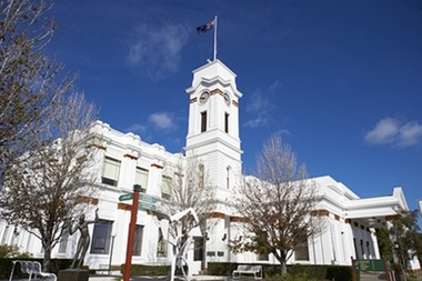
Originally known as Caulfield Shire Hall, the original 1884 building was designed by Shire surveyor Sydney Smith. In 1931 the Caulfield Town Hall, as it was then known, was remodelled to include the main hall and foyer and a Neo-Grecian portico with Corinthian Order columns. Major works completed since 1945 include Caulfield Arts Complex (opened 20 August 1988), Caulfield Library (opened 4 December 1993) and the award-winning Caulfield Municipal Offices extension which opened on 24 February 1991. The building is listed as No. H0106 in the GECC Heritage Overlay Schedule. The site also includes a Significant Tree (H&H Register No. 034). Brick exterior of two storey building painted white and featuring pillared portico entrance and solid glass doors on Glen Eira road facing north. On the eastern side of the portico is a two storey clock tower with clock surmounted by a flagpole and flag. Some of the eastern section of the building is original with various alterations over the years. The award winning service centre and offices in the westerly aspect of the town hall were extended on to the original buliding in 2000.building, town hall, council, local government, caulfield, glen eira, moorabbin, sydney smith -
Glen Eira City Council History and Heritage Collection
Robe
Official Municipal (?) Robe, Black pleated (woollen?) robe.Makers details printed in gold on cotton tag stitched on inner side, back of robe. -
Glen Eira City Council History and Heritage Collection
Greeting Card, June Evelyn Productions, After 1991
No date on card. Image includes the Caulfield Municipal Offices extension which was completed on 24 February 1991 therefore, the image must have been created after this date. Considered to be of significance as this is the only copy of this card sighted to date. Greeting card in, flips open, blank inside, with a printed sketch of the Caulfield Town Hall on the front. The card is cream coloured and the sketch is in red. The sketch includes the signature of the artist, "June Evelyn". The Town Hall is viewed looking from Glen Eira Road to the front of the Arts Centre Portico and showing the Caulfield Municipal Offices extension which was opened on 24 February 1991. Printed on back of card in same colour ink as printed sketch on the front of the card are the details of production. -
 Glen Eira City Council History and Heritage Collection
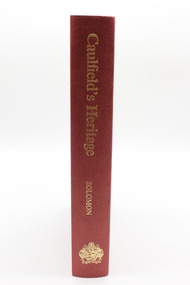
Book, "Caulfield's Heritage"
This book was written by Dr. Geulah Solomon.Single publication combining Volumes 1-4 of "Caulfield's Heritage" by Dr Geulah Solomon. Red hardcover book with gold embossed lettering down spine which reads 'Caulfield's Heritage Solomon' and post-1975 City of Caulfield Ensign. Housed in hardcover red sleeve. Includes Volume 1: Caulfield's Building Heritage, Volume 2: Caulfield's Cultural Heritage, Volume 3: Caulfield's Recreational Heritage, Volume 4: Caufield's Recent Municipal Heritage. -
 Glen Eira City Council History and Heritage Collection
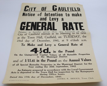
Flyer, The Craftsman Press Pty. Ltd, 1941
This flyer is entitled "City of Caulfield / Notice of Intention to make and Levy a General Rate" and served to notify residents that the Council of the City of Caulfield intended to "make and levy a General Rate of four and a half pence in the pound on the unimproved Capital Values of all Rateable Properties in the Municipal District and of 1/11.65 in the pound on the Annual Values of all Special Rateable Properties in the Municipal District for the Year ending the 30th September, 1942" at its meeting to be held at the Town Hall of Caulfield on Tuesday 23rd of December, 1941. The flyer bears the name of the Town Clerk, James R. Briggs. The flyer was printed by The Craftsmen Press for City of Caulfield, and is dated 17th December, 1941.Single page flyer printed on buff paper with black ink. Entitled "City of Caulfield / Notice of Intention to make and Levy a General Rate" -
 Glen Eira City Council History and Heritage Collection
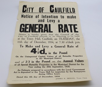
Flyer, 1934
This flyer is entitled "City of Caulfield / Notice of Intention to make and Levy a General Rate" and served to notify residents that the Council of the City of Caulfield intended to "make and levy a General Rate of four and a half pence in the pound on the unimproved Capital Values of all Rateable Properties in the Municipal District and of 2/3 in the pound on the Annual Values of all Special Rateable Properties in the Municipal District for the Year ending the 30th September, 1935" at its meeting to be held at the Town Hall of Caulfield on Tuesday 11th of December, 1934. The flyer bears the name of the Town Clerk, James R. Briggs. The flyer was printed by The Craftsmen Press for City of Caulfield, and is dated 4th December, 1934.Single page flyer printed on buff paper with black ink. Entitled "City of Caulfield / Notice of Intention to make and Levy a General Rate" -
Glen Eira City Council History and Heritage Collection
Document (Item) - Newspaper (digital), Caulfield Contact
The Caulfield Contact was the official newspaper of the City of Caulfield from 1976-1994. The City of Caulfield was the Municipal Council for an area of the South Eastern suburbs of Melbourne, including Brighton East, Carnegie, Caulfield, Elsternwick, Gardenvale, Glen Huntly, McKinnon, Murrumbeena, Ormond and St Kilda East. Following the amalgamation of City of Caulfield and parts of the City of Moorabbin in 1994, the municipality was renamed the City of Glen Eira. The Caulfield Contact was replaced by the Glen Eira News. 320-001-1976-001-001-07-28 Vol 1 edition 1 July 1976 Twenty-fifth (25th) anniversary of home help service; Profiles on Councillors Ray Mann, David Nolan; Murray and Wells call out for historical material; Resident's proposal for ward boundary changes accepted by Council, Profiles Councillor Bert Caldwell, Stan Hunter Town Hall Reprieve, History of Caulfield First Caulfield Arbor Day, Results of Council Elections held on 26 August 1976 city of caulfield, caulfield, history of caulfield, glen eira -
Glen Eira City Council History and Heritage Collection
Document (Item) - Newspaper (digital), Caulfield Contact
The Caulfield Contact was the official newspaper of the City of Caulfield from 1976-1994. The City of Caulfield was the Municipal Council for an area of the South Eastern suburbs of Melbourne, including Brighton East, Carnegie, Caulfield, Elsternwick, Gardenvale, Glen Huntly, McKinnon, Murrumbeena, Ormond and St Kilda East. Following Amalgamation of City of Caulfield and parts of the City of Moorabbin in 1994, the Caulfield Contact was followed by the Glen Eira News. Includes references to the following: Children's Neighbourhood Centre Caulfield; Fire destroyed Caulfield Park Bowling Club; Naming of Harleston Park; Home Handyman Service; Profiles Councillors Peter Baitz, Ron Walters; Carnegie-Glenhuntly Football Club formed Council drops approval of rail crossings over Neerim and Glenhuntly Roads; Profiles Councillor Alwyn Samuel, Glen Richards; First stage of Nepean Highway widening; Minister approved re-subdivision; Council spills; Exciting development of Caulfield Park; Profiles Councillor Max Blair, Councillor Brian Rudzki; Tram shelter classified by National Trustcity of caulfield, caulfield, glen eira, city of glen eira, caulfield contact, children's neighbourhood centre caulfield, fire destroyed caulfield park bowling club, naming of harleston park, home handyman service, profiles councillors peter baitz, ron walters, carnegie-glenhuntly football club formed, council drops approval of rail crossings over neerim and glenhuntly roads, profiles councillor alwyn samuel, glen richards, first stage of nepean highway widening, minister approved re-subdivision, council spills, exciting development of caulfield park, profiles councillor max blair, councillor brian rudzki, tram shelter classified by national trust -
Glen Eira City Council History and Heritage Collection
Document (Item) - Newspaper (digital), Caulfield Contact
The Caulfield Contact was the official newspaper of the City of Caulfield from 1976-1994. The City of Caulfield was the Municipal Council for an area of the South Eastern suburbs of Melbourne, including Brighton East, Carnegie, Caulfield, Elsternwick, Gardenvale, Glen Huntly, McKinnon, Murrumbeena, Ormond and St Kilda East. Following Amalgamation of City of Caulfield and parts of the City of Moorabbin in 1994, the Caulfield Contact was followed by the Glen Eira News. Contains References to the following Freedom of Entry to 3rd ordinance of the RAAOC, visit by Sir Zelman Cowen, Return to Rosstown, A 'spacy new home' (nursery at Caulfield Park), Profile on Gus Theobold, Meals on Wheels Aviary completed Caulfield Park. Profile resident Gus Theobold. Cr Irene Capek win Herald Australia Day essay prize. Caulfields Meals on Wheels set Victorian record. Historical feature Return to Rosstown. New ambulance station Glenhuntly and Clarinda roads opens. Volume 4 Number 5 Date 03 August 1978 Features Where and How to Vote in council election. Cr Irene Capek retires from council. Profiles election candidates. Image: Image Cr Irene Capek. Images of election candidates. Volume 5 Number 1 Date 14 September 1978 Freedom of Entry to 3rd ordinance of the RAAOC, visit by Sir Zelman Cowen, Subjects from Carol: GG Sir Zelman Cowen and Lady Cowen offical visit. Off street carpark project underway Pyne St and Hawthorn Rd. City Manager Graeme Caldwell submits plans for Townhall renovations. Action plan for development of Elsternwich Shopping precint to be developed. Freedom of Entry ceremony. Profile Rosemary Keppel. Booran Motors Glenhuntly donate dual control Holden Gemini to Caulfield Tech school pre-driver education program. council election results. Comments from elected Crs Jack Campell, Bob Baxter, Dorothy Ford, Brian Rudzki. Promotion of Caulfield Institute of Technology and TAFE. Image: Image Sir Zelman Cowen, Lady Cowen. Images Freedom of Entry ceremony and citizens attending. Image Rosemary Keppel. Cartoon pre-driver education program. Image Mayor Cr Geoff Patience in robes. Volume 5 Number 2 Date 26 October 1978 Rate rise 5.73% announced. Readership of Caulfield Contact surveyed. Caulfield ranger Reg Dixon and members of works dept rescue duck family from drain and reinstate them to Caulfield Racecourse dam. Profile resident and teacher Claire Manning. Image: Image of Reg Dixon and the rescued ducks. Image Claire Manning and students at Waverley Private school. city of caulfield, caulfield, glen eira, city of glen eira, caulfield contact, freedom of entry to 3rd ordinance of the raaoc, visit by sir zelman cowen, return to rosstown, a 'spacy new home' (nursery at caulfield park), profile on gus theobold, meals on wheels -
Glen Eira City Council History and Heritage Collection
Document (Item) - Newspaper (digital), Caulfield Contact
The Caulfield Contact was the official newspaper of the City of Caulfield from 1976-1994. The City of Caulfield was the Municipal Council for an area of the South Eastern suburbs of Melbourne, including Brighton East, Carnegie, Caulfield, Elsternwick, Gardenvale, Glen Huntly, McKinnon, Murrumbeena, Ormond and St Kilda East. Following Amalgamation of City of Caulfield and parts of the City of Moorabbin in 1994, the Caulfield Contact was followed by the Glen Eira News.city of caulfield, caulfield, glen eira, city of glen eira, caulfield contact