Showing 485 items
matching parcels
-
 Bendigo Historical Society Inc.
Document - MINING REPORTS - GOLD ESCORTS
Two typed copies of Gold Escorts, Some Statistics. First one is South Australia - Mt. Alexander to Adelaide for 1852 and 1853. Mentioned are number, Escort Commdr, departure and arrival, days return, parcels, weight of gold and value in pounds. For Victoria - Ballarat to Melbourne, Geelong and Mount Alexander to Melbourne for 1852 mentioning date, Govt. Gold, Private Gold, ounces and value in pounds. Escort Loadings Sample - Castlemaine 1853, ounces and cash. Escort Loadings - All areas, 1860, number of ounces and total. Also mentioned are Total Escort Loadings, Victoria for each year 1851 to 1862 in ounces and dwts. Document is part of the Albert Richardson Collection. document, gold, mining reports, mining reports, gold escorts, tolmer, alford, rose, stuart, lamb, cromie, wyndham, howell, malcolm blume, l j blake -
 Eltham District Historical Society Inc
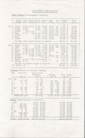
Photograph, The Jelbart Barn, 93 Arthur Street, Eltham, 1972c
Owned at the time by architect, Ian Jelbart, the property had been in the Jelbart family since the 1940s; a 5560sqm secluded hilltop parcel in Eltham. When the manor house and its barn were built, Eltham was a rural community; Jelbart’s grandfather Ronald was a businessman whose poultry farm formed part of the family’s original 100ha holding. A portion would later be subdivided into residential lots to make way for new homes that would form the basis of the Woodridge Estate in the early 1970s. The Barn was developed as a residence by Ian Jelbart in the late 1960;'s. Handmade mud bricks were used in its construction. This is a view from The Barn looking towards the Manor HouseDigital file only; created from scan undertaken by EDHSarthur street, eltham, houses, jelbart barn, jelbart property, kinloch gardens, verandah, mud bricks, enclosure -
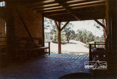
 Halls Gap & Grampians Historical Society
Photograph - B/W, C 1880
1880-1902 Land owned by Robert and Sarah Graham who owned a large portion of land best described as Upper Fyans Valley. At some time after 1880, they sold a parcel of the land under Sundial Peak to David Austin who built a slab hut. C1896, The land was sold to James and Amy Balmain which they named 'Bellfield' Amy was a daughter of John D/Alton who built the Stawell Water Supply System. Balmain purchased the vacant school cottage at Burnt Bridge and moved it to 'Bellfield' Over the next six years the house was enlarged to accommodate their growing family but sold in 1902 following the death of Amy Balmain.House with addition People leaving house by horse and carriage, people standing in groundsState Library Victoria, Rose's Australasian Views Victorian Series photographed and published by George Rose 123 Chapel St., Windsor, Victoriabuildings, houses, bellfield -
 Otway Districts Historical Society
Photograph, Crowes: Terminus of the railway line, 1911
The terminus of the railway, and the southern-most station on the Australian mainland, was Crowes, approximately 2 kilometres from Lavers Hill. The line ended at "The Black Stump". Crowes was designed as a fully functioning terminus and received a complete instalment of facilities. The site was laid out with three roads plus a dead end siding for a locomotive shed and ash pit. Goods sheds, a platform and livestock ramps catered for freight loadings, while on the north side was a station office, waiting room, parcels shed and passenger shelter. Three departmental residences were also provided. The resident Station Master was withdrawn in November 1916 and the station closed with the line on 10 December 1954.Photograph. Terminus of the Colac-Crowes at Crowes.crowes; terminus; "the black stump"; -
 Eltham District Historical Society Inc
Photograph, Frank Stokes with his mother Florence (nee West) and children, Dorothy (left), David (centre) and Beryl (right), Stokes Orchard, Nyora Road, Eltham, c.1950, 1950c
Frank's mother Florence was visiting from England at the time. Frank Stokes first traveled to the district by train in 1944 to find land with the intention to establish an orchard. By chance he met Arthur Bird of Bird Orchard (bounded by Pitt Street, Eucalyptus Road and Wattle Grove) and they got talking over their common interest. Arthur put Frank up for the night and pointed out the land, part of Crown Allotment 15, Section 5, Parish of Nillumbik (CA15) somewhat diagonally opposite Bird Orchard. Frank bought the land and for the next two years would travel by train from Melbourne to Eltham every weekend establishing Stokes Orchard and building a home for his family, which they eventually moved into in 1946. In the mid 1970s the Shire of Eltham divided the orchard up into numerous rate-able parcel lots, which became affordable for Frank. As a consequence Stokes Orchard was turned into a housing development by Macquarie Builders and marketed as the Stokes Orchard Estate in two stages; Stage 1 encompassing Scarlet Ash Court, Ironbark Close and Peppermint Grove bounded by Nyora and Eucalyptus roads c.1976 and Stage 2 encompassing Stokes Place, Orchard Way, The Crest and The Lookout bound by Nyora and Diosma roads c.1979. The development of Orchard Way, The Crest and The Lookout did not proceed as planned due to the lack of the sewer along Diosma Road and so many of the proposed lots were incorporated into five-acre parcels instead.Representative of the orchard growing areas of ElthamDigital file only - Digitised by EDHS from a scrapbook (containing commercially printed photos of digital scans) on loan from Beryl Bradbury (nee Stokes), daughter of Frank Stokes.1950, beryl bradbury (nee stokes), beryl bradbury (nee stokes) collection, david stokes, dorothy stokes, eltham, flatbed truck, florence stokes (nee west), frank stokes, nyora road, stokes orchard -
 Eltham District Historical Society Inc
Photograph, The Stokes family home blanketed with snow, corner Nyora and Eucalyptus roads, Eltham, winter 1951, 1951
Taken from outside the family home on the southest corner of the intersection of Nyora Road and Pitt Street with Eucalyptus Road. Frank Stokes first traveled to the district by train in 1944 to find land with the intention to establish an orchard. By chance he met Arthur Bird of Bird Orchard (bounded by Pitt Street, Eucalyptus Road and Wattle Grove) and they got talking over their common interest. Arthur put Frank up for the night and pointed out the land, part of Crown Allotment 15, Section 5, Parish of Nillumbik (CA15) somewhat diagonally opposite Bird Orchard. Frank bought the land and for the next two years would travel by train from Melbourne to Eltham every weekend establishing Stokes Orchard and building a home for his family, which they eventually moved into in 1946. In the mid 1970s the Shire of Eltham divided the orchard up into numerous rate-able parcel lots, which became affordable for Frank. As a consequence Stokes Orchard was turned into a housing development by Macquarie Builders and marketed as the Stokes Orchard Estate in two stages; Stage 1 encompassing Scarlet Ash Court, Ironbark Close and Peppermint Grove bounded by Nyora and Eucalyptus roads c.1976 and Stage 2 encompassing Stokes Place, Orchard Way, The Crest and The Lookout bound by Nyora and Diosma roads c.1979. The development of Orchard Way, The Crest and The Lookout did not proceed as planned due to the lack of the sewer along Diosma Road and so many of the proposed lots were incorporated into five-acre parcels instead.Representative of the orchard growing areas of Eltham. One of the rare times it has snowed in ElthamDigital file only - Digitised by EDHS from a scrapbook (containing commercially printed photos of digital scans) on loan from Beryl Bradbury (nee Stokes), daughter of Frank Stokes.1951, beryl bradbury (nee stokes) collection, eltham, eucalyptus road, nyora road, snow, stokes family home -
 Eltham District Historical Society Inc
Photograph, The first houses in construction on the new Stokes Orchard Estate, July 1976, July 1976
Viewed from near the Stokes family home at 1 Nyora Road looking northeast across Ironbark Close to Scarlet Ash Court with Peppermint Grove in the distance. Frank Stokes first traveled to the district by train in 1944 to find land with the intention to establish an orchard. By chance he met Arthur Bird of Bird Orchard (bounded by Pitt Street, Eucalyptus Road and Wattle Grove) and they got talking over their common interest. Arthur put Frank up for the night and pointed out the land, part of Crown Allotment 15, Section 5, Parish of Nillumbik (CA15) somewhat diagonally opposite Bird Orchard. Frank bought the land and for the next two years would travel by train from Melbourne to Eltham every weekend establishing Stokes Orchard and building a home for his family, which they eventually moved into in 1946. In the mid 1970s the Shire of Eltham divided the orchard up into numerous rate-able parcel lots, which became affordable for Frank. As a consequence Stokes Orchard was turned into a housing development by Macquarie Builders and marketed as the Stokes Orchard Estate in two stages; Stage 1 encompassing Scarlet Ash Court, Ironbark Close and Peppermint Grove bounded by Nyora and Eucalyptus roads c.1976 and Stage 2 encompassing Stokes Place, Orchard Way, The Crest and The Lookout bound by Nyora and Diosma roads c.1979. The development of Orchard Way, The Crest and The Lookout did not proceed as planned due to the lack of the sewer along Diosma Road and so many of the proposed lots were incorporated into five-acre parcels instead.Housing development in Eltham as an extension to the Woodridge EstateDigital file only - Digitised by EDHS from a scrapbook (containing commercially printed photos of digital scans) on loan from Beryl Bradbury (nee Stokes), daughter of Frank Stokes.1976-07, beryl bradbury (nee stokes) collection, building construction, ironbark close, nyora road, peppermint grove, scarlet ash court, stokes orchard estate, houses -
 City of Moorabbin Historical Society (Operating the Box Cottage Museum)
Badge - WWI Red Cross Buttons
The International Committee of the Red Cross was formed in 1862. Initially its purpose was to try and find ways of overcoming the inadequacy of army medical services so as to alleviate the suffering of those wounded in armed conflict. Over time it has extended its work to include many forms of humanitarian aid in times of peace and war. The Australian Red Cross Society (ARCS) was formed just after the outbreak of the First World War in August 1914, originally as a branch of the British Red Cross. It is especially remembered in the provision of “comforts” for soldiers overseas. Enormous sums of money were raised, and thousands of women volunteers contributed their time by making vast quantities of clothing: socks, vests, mittens, mufflers, pyjamas and a variety of linen. Items were sent to headquarters located in the state capitals, often using government houses as depots, where, after being sorted and packed by yet more volunteers, they were sent to Britain or the front. The effect of this work for the recipients was to bring comfort in its truest sense, for a seemingly trivial gift of a bar of chocolate of a pair of dry socks could bring the most profound relief for a soldier on the Western Front. From the date of its inception until the armistice the ARCS dispatched 395,695 food parcels and 36,339 clothing parcels Between 1914 and 1918 more than £3,500,00 was collected and spent on Red Cross services to the Australian Forces and Empire Forces. During WW1 and WW2 Red Cross raised funds selling buttons.Early settlers in Moorabbin Shire held fundraising events for the support of Red Cross Victoria and made cakes and knitted socks, gloves and scarves for distribution to serving men and women Metal buttons with printing on themRed Crossred cross, fund raising buttons, wwi, wwii, french red cross, british red cross, market gardeners, early settlers, moorabbin shire, bentleigh, cheltenham, caulfield repatriation hospital -
 City of Moorabbin Historical Society (Operating the Box Cottage Museum)
Badge - Red Cross - Springvale, 1917
The International Committee of the Red Cross was formed in 1862. Initially its purpose was to try and find ways of overcoming the inadequacy of army medical services so as to alleviate the suffering of those wounded in armed conflict. Over time it has extended its work to include many forms of humanitarian aid in times of peace and war. The Australian Red Cross Society (ARCS) was formed just after the outbreak of the First World War in August 1914, originally as a branch of the British Red Cross. It is especially remembered in the provision of “comforts” for soldiers overseas. Enormous sums of money were raised, and thousands of women volunteers contributed their time by making vast quantities of clothing: socks, vests, mittens, mufflers, pyjamas and a variety of linen. Items were sent to headquarters located in the state capitals, often using government houses as depots, where, after being sorted and packed by yet more volunteers, they were sent to Britain or the front. The effect of this work for the recipients was to bring comfort in its truest sense, for a seemingly trivial gift of a bar of chocolate of a pair of dry socks could bring the most profound relief for a soldier on the Western Front. From the date of its inception until the armistice the ARCS dispatched 395,695 food parcels and 36,339 clothing parcels Between 1914 and 1918 more than £3,500,00 was collected and spent on Red Cross services to the Australian Forces and Empire Forces. During WW1 and WW2 Red Cross raised funds selling buttons.This Carnival was an example of the support given to Red Cross by market gardeners, early settler families and schools in Moorabbin ShireDandenong Red Cross Carnival 1917red cross, dandenong, springvale, chelsea, dingley, keysborough -
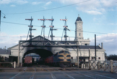 Ballarat Tramway Museum
Photograph - Digital image, W. J. Llewelyn, late 1960s
Set of three colour digital images taken by W. J. Llewelyn of the Ballarat Railway Station at Lydiard St North. .1 - Possibly a S class loco on the Horsham / Dimboola/Serviceton St, about to leave Ballarat station during the late 1960's or early 1970's. A freight train is on platform 2. Note the Parcels Office and that the clock had not been fitted to the station building. .2 - S305? shunting at Ballarat station, during the late 1960's or early 1970's. Photos taken from the signal box. .3 - R766 on a special train at the station - late 1980's. Has the failed Melbourne - Canberra - Sydney tourism venture carriages at the rear.trams, tramways, railway station, level crossings, lydiard st north, steam locomotive -
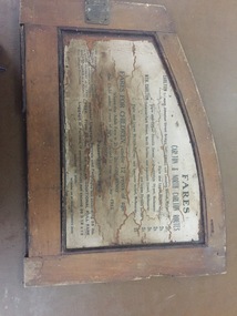 Melbourne Tram Museum
Functional object - Cable tram door frame piece/s, Melbourne Tramway & Omnibus Co. Limited, c1890
Fare board panel from Melbourne Cable tram saloon, from the inside or internal framing panels around a door. Made from soft wood, cut and assembled with wood screws, glued and then varnished. Part or panel that fitted over the end saloon window - fitted with hinges to allow access to the saloon door slide mechanism. Internal part of this part has a light colour finish on the rear. Details the fares for the Carlton / North Carlton routes. Also provides information on luggage and parcels. Issued by the MMTB. For detailed image of the panel, see the pdf file. Something not quite right when dB text opens it, open with a pdf reader to see the full text.trams, tramways, cable trams, components, fares, carlton, north carlton -
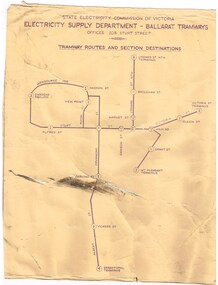 Ballarat Tramway Museum
Poster, State Electricity Commission of Victoria (SECV), "Schedule of Fares and Charges - 26-1-1969", Feb. 1971
704 - Dyeline print of a drawing showing Ballarat Tramway (SEC) Fares, Charges, and Section Map. Also gives charges for Scholar's Monthly tickets, Luggage, Parcels, Newspapers and Chartered trams. Printed from Drawing No. VIX/131/1. Titled "Schedule of Fares and Charges - 26-1-1969". 2nd copy of 704 added 4/10/2015 from donation of Brendan Allan. 704.1 - as above, but with mileages added by the SEC - 26-2-1971 as part of the Transport Regulation Board review of tramway and bus services pending the replacement of the tramways later in 1971. Shows mileages between the various fare points in the nearest 1/4 mile. Two copies held - one rolled longitudinally, the other vertically.trams, tramways, ballarat, fares, sections, map -
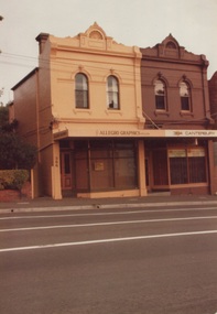 Surrey Hills Historical Society Collection
Photograph, 386-384 Canterbury Road Surrey Hills
The donor, Bob Lennox believed that these were the work of his great-grandfather William Lennox and his builders. William and his son were plasterers and often used the shell motif which is seen on the pediment of the buildings. These two terraces were part of the retail development of five terraces along Canterbury Road which were constructed on land subdivided from the parcel of land originally owned by John Woodhead. The Alan Holt register of properties in 3127 gives a list of proprietors / residents at the beginning of each decade from 1890-1980. There are also earlier photos depicting these buildings in the collection. These buildings have been included in the City of Boroondara Heritage Overlay Union Road Commercial Precinct 2011, Surrey Hills.These buildings were amongst the first commercial buildings serving the area of Surrey Hills and followed the extension of the railway from Camberwell in 1883.A colour photo with rounded corners taken from slightly diagonally across Canterbury Road from 2 double-storey Victorian style buildings. Both have the decorative shell motif in the pediment.Back of photo in green pencil "CANTERBURY RD SURREY HILLS / EAST OF UNION RD"victorian style, allegro graphics, william lennox, 386-384 canterbury road, shops, victorian terraces, canterbury road, surrey hills, john woodhead, heritage overlay union road commercial precinct 2011, heritage overlays -
 Eltham District Historical Society Inc
Photograph, Stokes family with horse and sled, Nyora Road, Eltham, c.1950, 1950c
Taken from outside the family home on the southest corner of the intersection of Nyora Road and Pitt Street with Eucalyptus Road, looking northeast across the Stokes Orchard Frank Stokes with children, Dorothy (left), Beryl and David Frank Stokes first traveled to the district by train in 1944 to find land with the intention to establish an orchard. By chance he met Arthur Bird of Bird Orchard (bounded by Pitt Street, Eucalyptus Road and Wattle Grove) and they got talking over their common interest. Arthur put Frank up for the night and pointed out the land, part of Crown Allotment 15, Section 5, Parish of Nillumbik (CA15) somewhat diagonally opposite Bird Orchard. Frank bought the land and for the next two years would travel by train from Melbourne to Eltham every weekend establishing Stokes Orchard and building a home for his family, which they eventually moved into in 1946. In the mid 1970s the Shire of Eltham divided the orchard up into numerous rate-able parcel lots, which became affordable for Frank. As a consequence Stokes Orchard was turned into a housing development by Macquarie Builders and marketed as the Stokes Orchard Estate in two stages; Stage 1 encompassing Scarlet Ash Court, Ironbark Close and Peppermint Grove bounded by Nyora and Eucalyptus roads c.1976 and Stage 2 encompassing Stokes Place, Orchard Way, The Crest and The Lookout bound by Nyora and Diosma roads c.1979. The development of Orchard Way, The Crest and The Lookout did not proceed as planned due to the lack of the sewer along Diosma Road and so many of the proposed lots were incorporated into five-acre parcels instead.Representative of the orchard growing areas of ElthamDigital file only - Digitised by EDHS from a scrapbook (containing commercially printed photos of digital scans) on loan from Beryl Bradbury (nee Stokes), daughter of Frank Stokes.1950, beryl bradbury (nee stokes), beryl bradbury (nee stokes) collection, david stokes, dorothy stokes, eltham, frank stokes, horse, nyora road, sled, stokes orchard -
 Eltham District Historical Society Inc
Photograph, Looking south towards Nyora Road, Eltham, 1977, 1977
Viewed from near the end of Stokes Place where the linear reserve now runs between 8 and 9 Stokes Place just visible through trees in foreground, 24 Nyora with red roof is the first house in middle of view. Frank Stokes first traveled to the district by train in 1944 to find land with the intention to establish an orchard. By chance he met Arthur Bird of Bird Orchard (bounded by Pitt Street, Eucalyptus Road and Wattle Grove) and they got talking over their common interest. Arthur put Frank up for the night and pointed out the land, part of Crown Allotment 15, Section 5, Parish of Nillumbik (CA15) somewhat diagonally opposite Bird Orchard. Frank bought the land and for the next two years would travel by train from Melbourne to Eltham every weekend establishing Stokes Orchard and building a home for his family, which they eventually moved into in 1946. In the mid 1970s the Shire of Eltham divided the orchard up into numerous rate-able parcel lots, which became affordable for Frank. As a consequence Stokes Orchard was turned into a housing development by Macquarie Builders and marketed as the Stokes Orchard Estate in two stages; Stage 1 encompassing Scarlet Ash Court, Ironbark Close and Peppermint Grove bounded by Nyora and Eucalyptus roads c.1976 and Stage 2 encompassing Stokes Place, Orchard Way, The Crest and The Lookout bound by Nyora and Diosma roads c.1979. The development of Orchard Way, The Crest and The Lookout did not proceed as planned due to the lack of the sewer along Diosma Road and so many of the proposed lots were incorporated into five-acre parcels instead.Housing development in Eltham as an extension to the Woodridge EstateDigital file only - Digitised by EDHS from a scrapbook (containing commercially printed photos of digital scans) on loan from Beryl Bradbury (nee Stokes), daughter of Frank Stokes.1977, beryl bradbury (nee stokes) collection, nyora road, stokes orchard estate, stokes place -
 Eltham District Historical Society Inc
Photograph, Stokes Place, Eltham, July 1977, July 1977
Viewed from near the end of Stokes Place where the linear reserve now runs between 8 and 9 Stokes Place looking slightly east of south towards Nyora Road. The new Christian Church on Nyora now the Baptist Church visible in middle view. Frank Stokes first traveled to the district by train in 1944 to find land with the intention to establish an orchard. By chance he met Arthur Bird of Bird Orchard (bounded by Pitt Street, Eucalyptus Road and Wattle Grove) and they got talking over their common interest. Arthur put Frank up for the night and pointed out the land, part of Crown Allotment 15, Section 5, Parish of Nillumbik (CA15) somewhat diagonally opposite Bird Orchard. Frank bought the land and for the next two years would travel by train from Melbourne to Eltham every weekend establishing Stokes Orchard and building a home for his family, which they eventually moved into in 1946. In the mid 1970s the Shire of Eltham divided the orchard up into numerous rate-able parcel lots, which became affordable for Frank. As a consequence Stokes Orchard was turned into a housing development by Macquarie Builders and marketed as the Stokes Orchard Estate in two stages; Stage 1 encompassing Scarlet Ash Court, Ironbark Close and Peppermint Grove bounded by Nyora and Eucalyptus roads c.1976 and Stage 2 encompassing Stokes Place, Orchard Way, The Crest and The Lookout bound by Nyora and Diosma roads c.1979. The development of Orchard Way, The Crest and The Lookout did not proceed as planned due to the lack of the sewer along Diosma Road and so many of the proposed lots were incorporated into five-acre parcels instead.Housing development in Eltham as an extension to the Woodridge EstateDigital file only - Digitised by EDHS from a scrapbook (containing commercially printed photos of digital scans) on loan from Beryl Bradbury (nee Stokes), daughter of Frank Stokes.1977-07, beryl bradbury (nee stokes) collection, eltham, eltham christian church, stokes orchard estate, stokes place -
 Federation University Historical Collection
Letter, F.W. Calaby, Letters from F.W. Calaby to School of Mines Ballarat, 18/07/1910
Clementston is a small gold town to the north of Creswick, Victoria. Formerly known as Beaconsfield, the Beaconsfield gold mining mullock heap is probably the sole remaining remnant of the village.Hand written noteClemontston 11/7/1910 Mr F.W. Martell Ser Sir, I am sending in a parcel of gold for smeling and sale with Mr Tolliday. Yours Faithfully F.W. Calaby. Clemontston, July, 18th 1910 Mr F.J. Martell Dear Sir I received your letter with cheque for 10 poinds 3 shillings 7 pence, also receipt for 5 shillings charges and I am very much obliged to you. Yours faithfully F.W. Calabyf.w. calaby, frederick martell, clementston, beacsonfield -
 Federation University Historical Collection
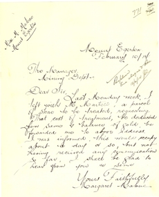
Letter - Correspondence, Margaret Malone, Letter regarding gold assay from Mount Egerton Mine, 10/02/2014
Margaret Malone was associated with a kaolin mine at Mount Egerton. WOMAN WHO MANAGES A MINE Works With A Vision (By a Special Corespondent) BALLARAT, August 22.—Like a Heroine in a Bret Harte story of the Soaring: Forties Miss Margaret Malone, the only woman mine manager in Australia, has lived most of her life in an atmosphere where hope springs eternal in the gold-seeking breast. Forty years ago her father gave up farming to seek the elusive mineral near Ballarat. "One day my mother went for a walk along the Gordon-Egerton road and picked up a pebble with a few specks of gold in it," she told an interviewer yesterday, recounting the early history of the nine she now runs at Egerton. "Dad said, There must be more where that came from,' and hopefully sank a shaft. Our hopes were dashed, however, when he found only white clay. No one realised then the value of the disappointing looking white stuff which was all that Dad could find from every shaft he sank. At last be gave up the search, and the kaolin remained untouched." Later an Englishman from a pottery town in the old country urged Mr. Malone to try and sell his clay, and he sent some to the Bendigo potteries, but nothing came of it, and it was left to Miss Malone, after her father's death, to start on her unusual career by finding purchasers in Sydney and Melbourne for her clay, and herself working the mine. Strenuous Work "Mine managing is strenuous work in more ways than one," she admitted. "I have, to go down my mine daily, ad sometimes have to descend perpendicular ladders for about 150 ft. to reach areas being worked. I have to be my own manager, she explained, "because it is necessary to teach the men I employ the methods of grading clays." A New Cure She is convinced that a number of uses for kaolin, apart from pottery, soap and drugs, are yet to be discovered. "One of my employees has already found a new use for it," she said, "although scarcely one to be generally recommended, perhaps. By chewing a small piece of the clay he firmly believes that he "cured himself of heart burn." "All That Glistens" There is more in Miss Malone's mining than meets the eye, however. The actual working of the field and the substantial profit she makes on it do not fill her days. Always before her - dangles the compelling vision that caused her father, in his day, to give up farming to seek for gold. "All the time I am getting my clay dug," she confessed, "1 am watching for the colour of gold. One of these days I may strike it." WOMAN WHO MANAGES A MINE Works With A Vision (By a Special Corespondent) BALLARAT, August 22.—Like a Heroine in a Bret Harte story of the Soaring: Forties Miss Margaret Malone, the only woman mine manager in Australia, has lived most of her life in an atmosphere where hope springs eternal in the gold-seeking breast. Forty years ago her father gave up farming to seek the elusive mineral near Ballarat. "One day my mother went for a walk along the Gordon-Egerton road and picked up a pebble with a few specks of gold in it," she told an interviewer yesterday, recounting the early history of the nine she now runs at Egerton. "Dad said, There must be more where that came from,' and hopefully sank a shaft. Our hopes were dashed, however, when he found only white clay. No one realised then the value of the disappointing looking white stuff which was all that Dad could find from every shaft he sank. At last be gave up the search, and the kaolin remained untouched." Later an Englishman from a pottery town in the old country urged Mr. Malone to try and sell his clay, and he sent some to the Bendigo potteries, but nothing came of it, and it was left to Miss Malone, after her father's death, to start on her unusual career by finding purchasers in Sydney and Melbourne for her clay, and herself working the mine. Strenuous Work "Mine managing is strenuous work in more ways than one," she admitted. "I have, to go down my mine daily, ad sometimes have to descend perpendicular ladders for about 150 ft. to reach areas being worked. I have to be my own manager, she explained, "because it is necessary to teach the men I employ the methods of grading clays." A New Cure She is convinced that a number of uses for kaolin, apart from pottery, soap and drugs, are yet to be discovered. "One of my employees has already found a new use for it," she said, "although scarcely one to be generally recommended, perhaps. By chewing a small piece of the clay he firmly believes that he "cured himself of heart burn." "All That Glistens" There is more in Miss Malone's mining than meets the eye, however. The actual working of the field and the substantial profit she makes on it do not fill her days. Always before her - dangles the compelling vision that caused her father, in his day, to give up farming to seek for gold. "All the time I am getting my clay dug," she confessed, "1 am watching for the colour of gold. One of these days I may strike it." (WOMAN WHO MANAGES A MINE Works With A Vision (By a Special Corespondent) BALLARAT, August 22.—Like a Heroine in a Bret Harte story of the Soaring: Forties Miss Margaret Malone, the only woman mine manager in Australia, has lived most of her life in an atmosphere where hope springs eternal in the gold-seeking breast. Forty years ago her father gave up farming to seek the elusive mineral near Ballarat. "One day my mother went for a walk along the Gordon-Egerton road and picked up a pebble with a few specks of gold in it," she told an interviewer yesterday, recounting the early history of the nine she now runs at Egerton. "Dad said, There must be more where that came from,' and hopefully sank a shaft. Our hopes were dashed, however, when he found only white clay. No one realised then the value of the disappointing looking white stuff which was all that Dad could find from every shaft he sank. At last be gave up the search, and the kaolin remained untouched." Later an Englishman from a pottery town in the old country urged Mr. Malone to try and sell his clay, and he sent some to the Bendigo potteries, but nothing came of it, and it was left to Miss Malone, after her father's death, to start on her unusual career by finding purchasers in Sydney and Melbourne for her clay, and herself working the mine. Strenuous Work "Mine managing is strenuous work in more ways than one," she admitted. "I have, to go down my mine daily, ad sometimes have to descend perpendicular ladders for about 150 ft. to reach areas being worked. I have to be my own manager, she explained, "because it is necessary to teach the men I employ the methods of grading clays." A New Cure She is convinced that a number of uses for kaolin, apart from pottery, soap and drugs, are yet to be discovered. "One of my employees has already found a new use for it," she said, "although scarcely one to be generally recommended, perhaps. By chewing a small piece of the clay he firmly believes that he "cured himself of heart burn." "All That Glistens" There is more in Miss Malone's mining than meets the eye, however. The actual working of the field and the substantial profit she makes on it do not fill her days. Always before her - dangles the compelling vision that caused her father, in his day, to give up farming to seek for gold. "All the time I am getting my clay dug," she confessed, "1 am watching for the colour of gold. One of these days I may strike it." (Adelaide Observer, 31 August 1929.)Hand written letter from Margaret Malone of the Mount Egerton Mine.Mount Egerton Mine February 10/14 The Manager Mining Dept Dear Sir, Last Monday week, I left with Mr Martell, a parcel of stone to be treated, requesting that cost of treatment, be deducted from some and balance of gold be forwarded me to above address. I was informed, this would occupy about a day or so, but not having received any communication so far, I shall be glad to hear from you are same. Yours faithfully Margaret Malonemargaret malone, female mine manager, kaolin, mount egerton, women -
 Melton City Libraries
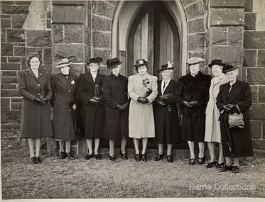
Photograph, Presbyterian Women's Missionary Union P.W.M.U, 1947
The P.W.M.U. was formed in May 1914, during the ministry of the Rev. Ben Williams. Mrs Williams presided at the first meeting. The object of the Union is to further the work of missions at home and abroad. t is responsible for mission work in china, Korea, New Hebrides, and deaconess work in the city.. Parcels of food are sent away from time to time. Last year the member made four quilts for the Babies’ Home. The Union has sustained severe losses in the departure from the district of Mrs I Robinson and Mrs E. Jessie Barrie: and Mrs Cameron was called to higher service on July 28th, 1947. The first President appointed was Mrs Atkin, Miss Macdonald, acted at Secretary of the Union for 22 years. For all the women who recognise the need of mission work for Christ, this Union is a wonderful opportunity for service. Presbyterian Women's Missionary Union (P.W.M.U): Mrs Jessie Barbarella nee (McIntosh) Miss Elsie Raleigh, Mrs Minnie Barrie nee Agar, Miss Jean Macdonald, Mrs Alison Raileigh?, Miss Christine McPherson, Miss Agnes Riddell, Miss Lois Raleigh and Mrs Ross.churches, local identities -
 Warrnambool and District Historical Society Inc.
Document - Warrnambool City Council Preliminary Report Industrial Estate West Warrnambool, E Johnson, 9 March 1973
This preliminary report relates to 32½ acres of council owned land in West Warrnambool bounded on the North by McMeekin Road, on the East by Scott Street, on the South by Evans Street and on the West by the rear boundaries of properties facing Landmann and Granter Streets. In 2010, West Warrnambool was the largest of Warrnambool’s existing industrial areas, comprising approximately 109ha of industrial zoned land, the majority of which (101ha) is zoned IN1Z, with the remainder zoned INZ3. The area comprises a mixture of lot sizes supporting a diverse mix of industries. Larger parcels are occupied by the abattoirs, scrap metal industries, freight, the Council Depot and storage. Smaller lots are occupied by smaller manufacturers and wholesalers and service industries. [Ref: Warrnambool Industrial Land Use Review. Mesh Pty Ltd July 2010]This document is a preliminary report prepared by the Warrnambool City Council Engineer in March 1973 and provides an example of the planning process undertaken to develop one of Warrnambool's industrial areas. It contains details and costings of the proposed subdivision. Two foolscaps size pages of typewritten information. A detailed topographical map of the area with areas highlighted in blue, red, green, blue and purple pen.warrnambool city council, west warrnambool, industrial estate -
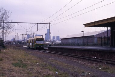 Melbourne Tram Museum
slide - Colour - Melbourne Trams, David Verrier, August 1989
1 - B2 2014 arriving Port Melbourne - showing Exhibition Route 111 - the tram stop is on the north side of the former railway platform at this time. 2- headon photo - shows the undeveloped nature of the background. 3 - W6 996 Spencer St with A2 288 behind - both trams running route 48 - note the Outward Parcels Office building and the VR Head Office. 4 - A2 288 and Z16 - as above 5 - Z16 as above - Route 75, showing East Burwood 6 - Z57 at La Trobe University terminus, route 87 7 - Z3 113 and Z1 9, both running route 86 - Bundoora - in High St 8 - Z3 186 at Bundoora terminus, with many people at the bus stop interchange.Yields information about Melbourne tram operations in Sept 1999Set of eight white / grey plastic slides, marked "CS System" and date stamped 08/89tramways, z3 class, b2 class, port melbourne, route 109, tram 2013, route 111, spencer st, tram 288, tram 996, route 48, w6 class, a2 class, z class, tram 16, route 75, tram 113, tram 9, bundoora, high st, la trobe university, tram 186 -
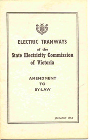 Ballarat Tramway Museum
Book, State Electricity Commission of Victoria (SECV), "Electric Tramways of the State Electricity Commission of Victoria Amendment to By-Law January 1962", Jan. 1963
Book cover has title "Electric Tramways of the State Electricity Commission of Victoria Amendment to By-Law January 1962". Pages are numbered pages 1 to 9 amending the 9/3/1937 By-Laws. Used to revise fares, parcel and luggage and charter rates in for Bendigo and Ballarat from 1/3/1963. Page 1 gives a list of amendments by date to the original by-law of 9/3/1937. Defines Pensioners and Child fares. Booklet dated January 1962, SEC Sealed the document 18/1/1962, Governor-In-Council approval granted 15/1/1963 and came into force 1/3/1963. Six copies held. See Fares in Ballarat – from Alan Bradley 11/4/2005 – appendix for Book. See item 9826 for the draft document. Yields information about SEC By-Laws regarding fares and sections.Twelve page booklet, plus medium weight card covers. Two copies (2 and 3) have written in pen on top right hand side of book "Ballarat Tramway Preservation Society Catalogue No. 205" and one copy (No. 5) "1962" on top of cover. Copy 3 has a formula in red ink on back cover.trams, tramways, secv rules, by laws, tickets, fares, ballarat, bendigo -
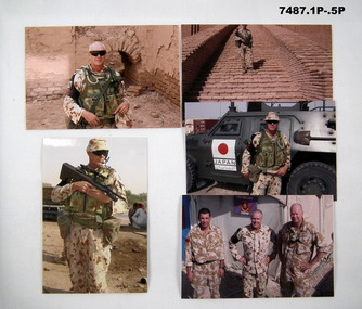 Bendigo Military Museum
Photograph - PHOTOGRAPHS - IRAQ
Items in the collection of Greg Westhead. Refer Cat No. 1496.7 for his service details.1. Photograph of Australian MP in desert camouflage, carrying equipment in front of an old brick building. 2. Australian MP in desert camouflage standing on steps of old building. 3. Australian soldier in desert camouflage and equipment. 4. Australian soldier in desert camouflage and equipment standing in front of a vehicle (Japan on the side). 5. Coloured photo of three soldiers in desert camouflage in front of a tent. 6. Coloured photo of a soldier in desert camouflage and equipment standing beside a civilian. 7. Coloured photo of people at a market including two soldiers in desert camouflage and equipment. 8. Coloured photo of a soldier surrounded by children in front of shops. 9. Coloured photo of soldiers near and in Bushmaster vehicle, a woman in black clothes carries a large parcel on her head.iraq, military vehicle, photographs -
 Bendigo Historical Society Inc.
Ephemera - JACK EMMETT COLLECTION: VICTORIANA PAPER CUT OUTS
JACK EMMETT COLLECTION Early 1900's Victoriana paper glossy scrap sheets cut-outs including 'Giant relief No. 895 - deer/rabbits -people animals and birds from around the world /angels -sign attached 'Gigantic Relief No.978 Raphael Tuck & Sons Ltd - Christmas cut-outs / 'Giant relief No. 920 / child wearing a bonnet carrying flask and a parcel titled 'Father's Dinner ' / picture of Postman titled 'The Jolly Postman / colour enhanced photo 'The Queen's Grandchildren -Child's Own magazine 1865 '- writing on back 'Prince Frederick William born …1859 , Princess Charlott .., Prince Henry / piece of paper with brown print - 'The Kings Business -Nicholson - Hemminger United Mission - Royal Princess Theatre -Evangelistic Services showing days with corresponding lecture subjects.Raphael Tuck & Sons Ltdephemera, mementoes, raphael tuck & sons ltd / -child's own magazine 1865 ' ./ nicholson - hemminger united mission -
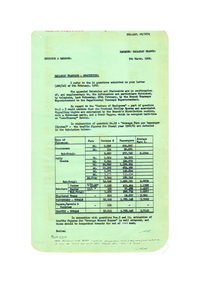 Ballarat Tramway Museum
Document - Report, State Electricity Commission of Victoria (SECV), "Ballarat Tramways - Statistics", Mar. 1962
Yields detailed information about the statistics of the Ballarat Tramway system during the 1960/61 Financial year, passenger loadings, finances and tramcar operation..1 - Report titled "Ballarat Tramways - Statistics", carbon copy, dated 5/3/1962, responding to a head office letter of 6/3/1962. Compiled in association with Schedules and Statements required, in response to specific questions for compilation of reports by the SEC. Details types of passengers (Pensions, Adults, Scholars, chartered trams, passenger totals including parcels) for 1960/61. .2 - Four foolscap sheets giving details of fares and charges, route length, services, fare sections, length of fare sections, employees, trams in service, tram usage, area and population served, expenditure, revenue, loss, average fare per passenger and extra trams needed for events. Also refers to Reg Item 7932 and 7951 for the original request. All sheets have rounded corners.trams, tramways, reports, passengers, employees, fares, tramcars, routes, revenue, finances, tickets -
 Ballarat Tramway Museum
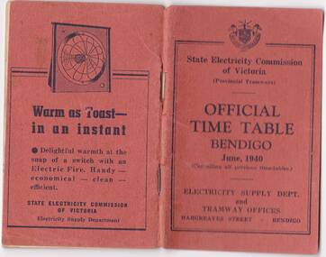
Photograph - Digital image, State Electricity Commission of Victoria (SECV), "Official Timetable Bendigo June 1940"
Yields information about the Bendigo Tram services.Digital image or copy of the SEC "Official Timetable Bendigo June 1940", 22 image files - 44 pages, giving details of the fares, transfers, luggage or parcels, lost property, times of each tram on the Quarry Hill, Eaglehawk, Lake Weeroona and Golden Square for both directions and Monday to Thursday, Friday, Saturday and Sunday. Has a number of advertisements for SEC home equipment, cookers, toasters, refrigerator, electric radiators and hot water. In the middle page is a map of the Tramway Routes, which has been hand drawn to shown North Bendigo and the depot location. Inside the rear cover, on a sheet headed "Memorandum" is a photograph, taped in of a conductor loading a pram onto a Birney tram. Under the photograph is in ink "Len Smith (Geelong)" See item3127 for an original copy and pdf scan. trams, tramways, bendigo, timetables -
 City of Kingston
Photograph - Black and white, 20 December 1945
This aerial photograph depicts the changing landscape of Cheltenham and Highett since WWII. Photographed in 1945, there is a mix of urban dwellings and industrial development and precedes the major transformation of Cheltenham with the development of the Southland shopping centre in the 1960s and expansion in the 1990s.A large part of Cheltenham was originally established as a rural market gardening community. The railway line and station brought urban development to the area and in the north, the Highett area was dominated by the Highett Gas Works. Cheltenham became a major destination for shopping in the 1960s with the opening of Southland.Aerial photograph taken in 1945 of Cheltenham and Highett within the City of Kingston. The image includes the Highett Reserve, (top right), the Methodist Children Homes (now Southland), Nepean Highway and Jamieson Street. Highett Gas Works is visible in the top left and the land now named William Fry Reserve at the intersection of Bay Road and Nepean Highway. A visible large parcel of land on the corner of Bay Road and Nepean Highway was developed in the 1990s as the west side addition to Southland. The densely vegetated area in the upper right sector of the image is now dense with housing. Tulip Grove, Heather Grove and Gilford Street are visible bottom left. This image is possibly from the collection of aerial photographs commissioned by the Department of Crown Lands and Survey and taken by Adastra Airways.Black ink: 57252 White lettering: VIC-10 57252 20.12.45 [lens information indecipherable] PROJ. No.5 MELB. METROP AREA Black pencil: 80highett, cheltenham, highett gas works, urbanisation -
 City of Kingston
Photograph - Black and white, 20 December 1945
This aerial photograph depicts the changing landscape of Cheltenham and Highett since WWII. Photographed in 1945, there is a mix of urban dwellings and industrial development and precedes the major transformation of Cheltenham with the development of the Southland shopping centre in the 1960s and expansion in the 1990s.A large part of Cheltenham was originally established as a rural market gardening community. The railway line and station brought urban development to the area and in the north, the Highett area was dominated by the Highett Gas Works. Cheltenham became a major destination for shopping in the 1960s with the opening of Southland.Aerial photograph taken in 1945 of Cheltenham and Highett within the City of Kingston. The image includes the Highett Reserve, (top right), the Methodist Children Homes (now Southland), Nepean Highway and Jamieson Street. Highett Gas Works is visible in the top left and the land now named William Fry Reserve at the intersection of Bay Road and Nepean Highway. A visible large parcel of land on the corner of Bay Road and Nepean Highway was developed in the 1990s as the west side addition to Southland. The densely vegetated area in the upper right sector of the image is now dense with housing. Tulip Grove, Heather Grove and Gilford Street are visible bottom left. This image is possibly from the collection of aerial photographs commissioned by the Department of Crown Lands and Survey and taken by Adastra Airways.Black type: Reverse lettering VIC-10 57252 20.12.45 [lens information indecipherable] PROJ. No.5 MELB. METROP AREA White lettering: Reverse writing 57252cheltenham, highett, highett gas works, urbanisation -
 Ballarat Tramway Museum
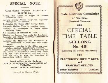
Photograph - Digital image, State Electricity Commission of Victoria (SECV), "Official Timetable Geelong No. 45"
Digital image or copy of the SEC "Official Timetable Geelong No. 45", 16 image files - 32 pages, giving details of the fares, transfers, luggage or parcels, lost property, times of each tram on the Belmont (1), Chilwell (2), East Geelong (3), Eastern Park (4), Newtown (5), North (6), West Geelong (7). Gives details of railway station trams, transfer ticket arrangements, depot workings and the night signs carried out each tram. Based on the 4d max fare, it is a circa 1949 timetable - see reference. See also Reg Item 5629 for Timetable No. 39, c1943 and 8552 for a photocopy of No. 47, March 1953 and 9821 for a photocopy of No. 46. See BTM document, "SEC fare changes - by law references etc.doc, dated 3/9/2006.trams, tramways, geelong, timetables -
 Eltham District Historical Society Inc
Photograph, Stokes family, Nyora Road, Eltham, c.1952, 1952c
Taken from outside the family home on the southest corner of the intersection of Nyora Road and Pitt Street with Eucalyptus Road, looking northeast across the Stokes Orchard L-R: David, Howard, Beryl (kneeling), Dorothy and Gladys Stokes with Gladys's mother sitting in Gladys's father's car with Spot the dog, Nyora Road, Eltham, c.1952 Frank Stokes first traveled to the district by train in 1944 to find land with the intention to establish an orchard. By chance he met Arthur Bird of Bird Orchard (bounded by Pitt Street, Eucalyptus Road and Wattle Grove) and they got talking over their common interest. Arthur put Frank up for the night and pointed out the land, part of Crown Allotment 15, Section 5, Parish of Nillumbik (CA15) somewhat diagonally opposite Bird Orchard. Frank bought the land and for the next two years would travel by train from Melbourne to Eltham every weekend establishing Stokes Orchard and building a home for his family, which they eventually moved into in 1946. In the mid 1970s the Shire of Eltham divided the orchard up into numerous rate-able parcel lots, which became affordable for Frank. As a consequence Stokes Orchard was turned into a housing development by Macquarie Builders and marketed as the Stokes Orchard Estate in two stages; Stage 1 encompassing Scarlet Ash Court, Ironbark Close and Peppermint Grove bounded by Nyora and Eucalyptus roads c.1976 and Stage 2 encompassing Stokes Place, Orchard Way, The Crest and The Lookout bound by Nyora and Diosma roads c.1979. The development of Orchard Way, The Crest and The Lookout did not proceed as planned due to the lack of the sewer along Diosma Road and so many of the proposed lots were incorporated into five-acre parcels instead.Representative of the orchard growing areas of ElthamDigital file only - Digitised by EDHS from a scrapbook (containing commercially printed photos of digital scans) on loan from Beryl Bradbury (nee Stokes), daughter of Frank Stokes.1948-1951 vauxhall velox, 1948-1951 vauxhall wyvern, 1952, beryl bradbury (nee stokes), beryl bradbury (nee stokes) collection, david stokes, dorothy stokes, eltham, gladys stokes, nyora road, spot (dog), stokes orchard