Showing 1360 items matching "parks and reserves"
-
 Bendigo Historical Society Inc.
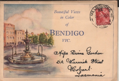
Postcard - VIEWS OF BENDIGO - FOLD OUT PHOTOS IN FOLDER
Sepia coloured folder, enclosing photos of Bendigo. On front 'Beautiful Views in Color of Bendigo Vic.' Photo of Alexandra Fountain on LH side. 3 1/2d stamp on top RH corner. Folder addressed to Miss Diane Gordon 5A Warwick Street, Hobart, Tasmania. Colour photos include : Alexandra Fountain, The City Hall, The Botanic Gardens, Hargreaves Street, The Conservatory Gardens, Rosalind Park, Pall Mall, The Upper Reserve Lake and The Conservatory Gardens. Photos appear to be from the 1940's. Enclosed letter states that the donor's grandfather 'mailed them me during his visit to your city in what appears to be 1953. Diane Palmer'Valentine Publishing Co Pty Ltdbendigo, tourism, post card folder -
 Eltham District Historical Society Inc
Photograph - Digital Photograph, Marguerite Marshall, Eltham Lower Park, 20 April 2008
Originally a race course, the park has brought the community together with a variety of activities. Published: Nillumbik Now and Then / Marguerite Marshall 2008; photographs Alan King with Marguerite Marshall.; p45 Once used for horse racing, which attracted visitors from Melbourne, the Eltham Lower Park has brought the community together with a wide range of activities. Horse riding is now enjoyed as a recreation in the park as are other sports. The park also includes the Diamond Valley Railway miniature trains and a sanctuary for the rare and vulnerable Eltham Copper Butterfly. Eltham Lower Park, with other parks, forms an almost continuous green band from Eltham’s centre, along the Diamond Creek to the Yarra River.1 Before European settlement the Wurundjeri people met on this land, particularly at the junction of the Diamond Creek with the Yarra River, which they called Birr-arung. This is commemorated by the sculpture, Not just a Pretty Place by Aleks Danko, winner of the 2000 Nillumbik Art in Public Places Award. The first European to settle here was probably Henry Foley, who in 1841 used it as part of his pastoral run. Foley sold his leasehold to Joseph Wilson in 1845, who soon after sold it to Frederick Falkiner. During the 1840s the future park was part of a government square mile (2.6 sqkm) reserve, north of the Yarra, within the Parish of Nillumbik, later named Eltham. Soon the land was used for horse racing after nearby residents cleared ten acres (4ha) in the early 1850s. A three-quarter of a mile (1.2km) race secured the winner the £10 Publican’s Prize. In response to popular demand, the newly formed Eltham District Road Board petitioned the Surveyor General of the Colony of Victoria, in 1856, for 36 acres (14.6ha) of crown land for a racecourse and recreation. By 1858 the Eltham races had become an institution. ‘Many skirmishes occurred and the way home was paved with temptation, with sly-grog for sale.3 In the early 1870s, two jockeys were sons of the police officer in charge of the Eltham Police Station, Miles S Lyons. Another ten acres (4ha) was added to the area in 1866 and 12 acres (4.8ha) – Hohnes Hill – in 1870. In 1866, two acres (0.8ha) on the creek banks became an animal pound with William Walsh the pound keeper in 1870, but this was later incorporated into the park. By 1877 the area was called a public park but horse racing and training continued into the 1920s. In the mid-1900s trotters were trained on a circuit road. In 1953 the Eltham Pony Club was established and used a cross-country course on Hohnes Hill. From the mid 1950s the club held the Eltham Easter Fair at the park, later to include a procession along Main Road from the town centre to the park. The park also attracted picnic parties and campers from the inner suburbs as did Wingrove Park, and businesses catering for visitors, sprang up on the opposite side of Main Road. Bus-loads of school children visited the park for Gould League bird days in the 1960s. In 1979 the Eltham Shire Council bought Lenister Farm, linking the park with the Yarra River. The Lenister Farm wetland includes a bird hide, viewing platform and interpretive signs.5 Pioneer Henry Stooke, later Road Board chairman, bought the 11 acres (4.5ha) - later to become Lenister Farm - from the Crown in 1862. Stooke never lived on this site and the two houses at Lenister Farm were built in the 20th century. Since its formation in 1871, the Council has controlled this crown land, which it named Eltham Park. But in the 1920s Eltham Council bought land near the town centre for a park, which it named Eltham Central Park. To avoid confusion the Council renamed Eltham Park, Eltham Lower Park. Since 2004 the Yarra footbridge has linked the park with the Yarra Valley Metropolitan Park and the Main Yarra Trail.This collection of almost 130 photos about places and people within the Shire of Nillumbik, an urban and rural municipality in Melbourne's north, contributes to an understanding of the history of the Shire. Published in 2008 immediately prior to the Black Saturday bushfires of February 7, 2009, it documents sites that were impacted, and in some cases destroyed by the fires. It includes photographs taken especially for the publication, creating a unique time capsule representing the Shire in the early 21st century. It remains the most recent comprehenesive publication devoted to the Shire's history connecting local residents to the past. nillumbik now and then (marshall-king) collection, eltham lower park, eltham park -
 Eltham District Historical Society Inc
Document - Property Binder, 1225 Main Road, Eltham
Newspaper article: Order upsets family, Diamond Valley Leader, 5 October 2005, Helen Fitzpatrick ordered to vacate Nillumbik Council owned property at Alan Marshall Reserve for creation of a park. Newspaper article: Nature calls again for a real blessing, Diamond Valley Leader, 5 October 2005, St Margaret's Anglican Church to hold annual blessing of the animals service. Newspaper article: Family gets council reprieve on house until 2007, Diamond Valley Leader, 12 October 2005, Helen Fitzpatrick permitted to remain at property until 2007.main road, eltham, helen fitzpatrick, anna fitzpatric, molly fitzpatrick, ellen fitzpatrick, alan marshall reserve, bronnie hattam, bill forrest, greg johnson, libby delbridge, st margaret's anglican church eltham, gordon roberts -
 Ballarat Tramway Museum
Map, Electric Supply Co. of Vic (ESCo), Ballarat Electoral Map - ESCo, 1900
Document prepared by the Electric Supply Co of Victoria, as part of an order under the Electric Light and Power Act 1896, section 5 of order No. 17 granted to company. Dated 19/2/1901 and signed by the Postmaster-General. Shows the order area being parts of the City of Ballaarat, Sebastopol and Ballarat East. Shows the street names, boundaries, principal power line routes, land reserves, parks, mine locations, railways and Lake Wendouree. Signed by R L Williams Town Clerk City of Ballarat, J R Hall for the Borough of Sebastopol, and John Gent for the Town of Ballarat EastYields information about the power supply to the Ballarat area.Cloth backed paper map, coloured and marked up as exhibit 17.Notes in ink including the signature of Benjamin Deakin 24/9/00 and certified by the three involved municipal Town Clerks.ballarat power supply, esco, electric supply co of victoria, city of ballaarat, east ballarat, sebastopol, orders, power lines, power supply -
 Eltham District Historical Society Inc
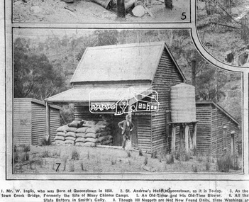
Photograph, Queenstown - St. Andrews District. "Quartz awaiting crushing at the State Battery in Smith's Gully.", c.1929
"The State Battery was the central component in the gold mining of this area from the 1920s. The battery crushed the gold bearing quartz extracted from the mines and was a sizeable weatherboard building enclosing the engine and stampers. All that now remains are the bases for the machinery that comprised the battery, one timber and a couple of concrete bases and the nearby dam, which supplied water. However the historic significance of the site remains and is enhanced by the Queenstown Cemetery on the other side of Smiths Gully Road". - Bick Study 1922 This site is now the Peter Franke Reserve and is managed by Parks Victoria Photo Source: The Leader, Nov. 2nd, 1929This photo forms part of a collection of photographs gathered by the Shire of Eltham for their centenary project book,"Pioneers and Painters: 100 years of the Shire of Eltham" by Alan Marshall (1971). The collection of over 500 images is held in partnership between Eltham District Historical Society and Yarra Plenty Regional Library (Eltham Library) and is now formally known as the 'The Shire of Eltham Pioneers Photograph Collection.' It is significant in being the first community sourced collection representing the places and people of the Shire's first one hundred years.Digital imagesepp, shire of eltham pioneers photograph collection, queenstown, st andrews, gold mining, smiths gully -
 The Beechworth Burke Museum
Photograph, c1960
The photograph depicts a view across the water at Lake Sambell. The image is thought to date from the 1960s so may show the lake during a period of drought, such as that experienced across South-Eastern Australia in 1967. The present day park and reserve occupies the site of the former Rocky Mountain Mining Company, an open-cut sluice mine that began operations in the mid-Nineteenth Century and operated until the early 1900s, through the peak of Victoria’s Gold Rush. It was converted into a park and leisure area in the 1920s. Lake Sambell was formally opened to the public on Friday 5th October 1928 and was opened by the Victorian Government’s Minister of Lands, Mr Bailey, as part of initiatives to boost the economies and development of country towns. The lake was named after Mr L.H. Sambell, a shire engineer and secretary of the Forward Beechworth Committee who was involved in promoting the transformation of the mining site and promoting plantation forestry and tourism as alternative industries. £300 to begin the process was provided by Mr J. McConvill, a former resident of Beechworth, who is remembered in a street name adjacent to the lake. Residents of Beechworth have worked to raise funds to improve the Lake Sambell reserve several times, such as efforts in the 1930s and 1940s to raise the banks several feet to deepen the water for swimming purposes. Fundraising campaigns include the ‘Ugly Man’ competition conducted on behalf of the Wallace Park-Lake Sambell Development Scheme. The latter competition was run by the Fire Brigade Bend’s team as part of a larger competition called the ‘Mile of Pennies’; it was won by Mr Len Knight of Beechworth’s Commercial Hotel. The ‘Mile of Pennies’ was conducted at a Carnival held on New Year’s Eve, 1947. It was proposed by the Beechworth and District Progress Association. As well as improving swimming facilities, funds were raised to install a caravan park facility near the lake. Funds were also donated by commercial entities, such as £250 received from Zwar Bros. Pty Ltd.The photograph is significant as it shows Lake Sambell at lower water levels, such as may have been experienced during period of drought.Sepia rectangular photograph printed on matte photographic paperObverse: nil Reverse: 3470beechworth, beechworth lake, lake sambell, lake, beechworth and district progress association, forward beechworth committee, ugly man, mile of pennies, wallace park lake sambell development scheme, wallace park-lake sambell development scheme, zwar bros, zwar, l.h. sambell, j. mcconvill, minister of lands, commercial hotel, len knight, rocky mountain mining company, rocky mountain mining co, gold rush, redevelopment, transformation, community fundraising, drought, 1967, 1960s -
 Eltham District Historical Society Inc
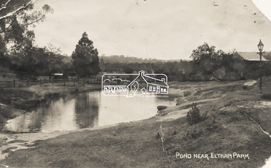
Photograph - Photo Postcard, Pond near Eltham Park, c.1910
This card depicts the pond near Eltham Park (later Eltham Lower Park) circa 1910. The view is taken from Maria Street (Main Road) opposite Dalton Street looking northwest across the Dalton Street road extension reserve (now Wingrove Park Trail) and Jarrold farm. A haystack is visible. Also visible is a gas streetlight and White Cloud cottage which belonged to the Jarrold family From the same collection as accession no. 00778, (Yarra at Eltham) - sent from Eltham and addressed to "Mr J. L. Brown, "Elthamville", Tinning Street, Brunswick" "with love from Nellie" who was most probably a member of the extended Brown family, and no. 00780 (Eltham, J.H. Clark Photo - dated 20 May 1911). Sending postcards to family and friends including short messages was a common form of communication in the early 20th century. Part of a slide show presentation "Bridges & Waterways of the Shire" by Russell Yeoman to the 13 September 1989 Society meeting. The presentation included slides of historic photos from the Shire of Eltham Pioneers collections as well as several recent views.Sending postcards to family and friends including short messages was a common form of communication in the early 20th century.Sepia postcard in very poor condition which has been removed from an album. Glue residue and album page adhering preventing information being readFront: Pond near Eltham Parkpostcard, eltham, pond, dalton street, duck pond, eltham park, elthamville, gas lamp, haystack, jarrold cottage, jarrold property, main road, maria street, white cloud cottage, wingrove park trail -
 Whitehorse Historical Society Inc.
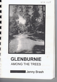
Book, Glenburnie among the trees, 1997
History of Glenburnie Road, VermontHistory of Glenburnie Road, Vermont prepared by Jenny Brash, 1997. Includes a brief history of Vermont with maps of the area. Mentioned are gold mining, orchards, farming and the tile factories. Visits by gypsies. The flora of the area. The establishment of Bloom Reserve and Hales Park, the Kirkpatrick Homes and the Vermont Elderley People's Homes. People mentioned include Paton 1940-53, Hamilton ca 1935, Brereton ca 1937-70, Tovey ca 1930-60, Rawson 1943-, Palmer 1937-, Ken Hauser 1956-, Kirkpatrick 1924-68, Hale 1946-, Esme White, Tom and Pat Fagetter, Francis Hall 1924-, Leonard Uren 1922- (Farley Green Estate). 33 pages, photographs, maps.History of Glenburnie Road, Vermont glenburnie road, vermont, brash, jenny, bloom reserve, hales park, native plants -
 Bendigo Historical Society Inc.
Map - HUSTLERS LINE OF REEFS - LONGITUDINAL SECTION THROUGH THE SADDLE REEFS
Drawing with Longitudinal Section through the Saddle Reefs along portion of Hustler's Line of Reefs, Bendigo. Map shows the depth of the mines, reef numbers and Datum 700 ft above sea level. North and South is also noted on the map. Map signed by H. S, Whitelaw, Underground Survey Office, Bendigo, September 1913. Bulletin No 33, Plate No XXXIV. Bendigo Creek, Ironbark Creek and Long Gully are also noted. Mines are: Fortuna Hustlers, Hustler's Royal Reserve No 2 Main Shaft, Hustler's Royal Reserve No 2 Park Shaft, Royal Hustler's, Imperial Hustler's, Extended Hustler's Freehold, Great Extended Hustler's Tribute (Pups), Old Shaft, Great Extended Hustler's Reef No 2, Great Extended Hustler's Main Shaft, Old Shaft, Hustler's Reef, Hustler's Reef No 1, Comet, K. K., United Hustler's & Redan, Old Shaft and Hustler's Consols. Has Geological Survey of Victoria Crest and underneath is: H. Herman, Director, W. Dickson, Secretary for Mines, The Hon. J Drysdale Brown M L C. Minister of Mines.Geological Survey of Victoria Crestmining, hustler's reef maps, hustlers line of reefs, bendigo creek, royal hustler's, imperial hustler's, extended hustler's freehold, great extended hustler's tribute (pups), great extended hustler's reef no 2, great extended hustler's main shaft, hustler's reef, hustler's reef no 1, united hustler's & redan, old shaft and hustler's consols.h s whitelaw, underground survey office bendigo september 1913 -
 The Beechworth Burke Museum
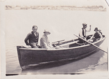
Photograph, 1920
Taken in 1920, depicted are four people in a rowing boat on Lake Sambell, Beechworth. From left to right, it is believed that the names of the people are Eric Beard, Mrs Doris Beard, and S/L to Bert Beard. The last two figures are unknown. Lake Sambell is a beautiful Victorian recreation lake and urban park with a unique history. It was created in the mid-1800s by the Rocky Mountain Mining company during the gold rush era and used as a mining site until the early 1900s, which brought Europeans into the area. It was turned into a reserve for residents in 1920 and is considered an icon of Beechworth as it represents the development of the community, human endeavour, and the spirit of the landscape.This photograph represents the community's social use of the lake in 1920.Black and white rectangular photograph print on paper.Reverse: LAKE SAMBELL/ c 1920/ from LTOR/ 1 ERIC? - BERT'S SON/ 2 MRS DORIS BEARD/ 3 S/L TO BERT BEARD/ 4 #beechworth, lake sambell, lake sambell boating, beechworth lake, social, 1920, victoria -
 Warrnambool and District Historical Society Inc.
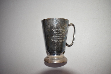
Golf Club Trophy, 1950
This item comes from the estate of Dorothy and Agnes Ardlie of Warrnambool. Dorothy Ardlie (1910-1993) and Agnes Ardlie (1915-1993) were the daughters of Arthur and Ethel Ardlie of Warrnambool, the granddaughters of the prominent Warrnambool lawyer, William Ardlie and his wife Mary and the great granddaughters of John and Mary Ardlie, pioneer settlers in Warrnambool. The trophy was won by Agnes Ardlie in 1950. The Warrnambool Golf Club was established in the late 19th century and the game was played by both men and women at Albert Park until 1929 when it shifted to its present day course in what was once part of the old Western Reserve. This trophy is of interest as a mid 20th century memento of a member of a prominent family in Warrnambool, Miss Agnes Ardlie and of the Warrnambool Golf Club.This is an electro-plated nickel silver mug with a circular base, a tapering body and a handle. It is much stained. There is an inscription on one side of the mug and a maker’s name on the base but this is not decipherable. Warrnambool Golf Club ‘B’ Grade Scratch Event 1950 Miss A.M. Ardlieardlie family, history of warrnambool -
 Victorian Interpretive Projects Inc.
Photograph - Colour, Clare Gervasoni, Tower Hill, Victoria, 2013, 2013
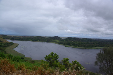
The Tower Hill Reserve is located inside a dormant volcano, and features a lake and wetlands. It became Victoria's first national park in 1892, but by the 1930s the early settlers had cleared much of the land for grazing, cropping and quarrying. In the 1960s the bare hills and islands were revegetated based in species identified from Eugene von Guerard's painting of Tower Hill. Tower Hill was formed around 30,000 years ago in a violent volcanic eruption. The initial eruption created the outer rim of the volcano, and later smaller eruptions formed the internal hills that are evident today. The layers of volcanic ash layers include artefacts relating to indigenous communites.A series of colour digital photographs showing Tower Hill, near Port Fairy, Victoria. Tower Hill is an extinct volcano.tower hill, volcano, extinct -
 Kew Historical Society Inc
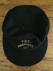
Uniform, K.B.C. Premiers 1927
The Victorian Baseball League was established in 1889 with the following clubs - MCC, Metropolitan, Richmond, Richmond Cricketers, Kew, Geelong, Fitzroy, The Age, Carlton, Coburg. MCC defeated Metropolitan for the first Premiership. By 1897 Kew had built up to six teams, but went into recess about the turn of the century. They reformed c.1906 and did not resume until 1926 under Captain/Coach Frank Littlefield. I think he was ex Hawthorn Baseball and/or Cricket club(s). They won the D Grade Premiership of 1926 and/or 1927 playing out of Victoria Park at 12 noon, and as a curtain raiser to either Kew or Kew District or East Kew Football Club and after World War 2, North Kew which had now joined Kew as a tenant. Team members were H.L. Barclay (ex Richmond), A. Brierley (ex Collingwood), H. Ely (ex Essendon), Frank Littlefield, J. Marshall and C. Robinson (ex Hawthorn-East Melbourne Cricket Club). In 1926, the KBC played against Caulfield, Fairfield, Fitzroy, Ivanhoe, Northcote, Prahran, University, Williamstown, YMCA. In 1927, Preston replaced Fairfield. A third team was formed post WW2 which played at Willsmere Park. The Reserves followed to Willsmere Park in 1963 and the Seniors in c.1970. Kew Council moved the club to a sub-standard Stradbroke Park No 2 Oval for the 1976 season and this proved to be the last for the club. Melbourne Baseball Club moved in for two seasons, but also moved when improvements to No 2 Oval were not made. They then moved to Macleay Park in a share arrangement with North Balwyn BC. Research: Ian Job, 2015A premiership cap awarded to Christopher Robinson of the Kew Baseball Club in 1927.Navy blue peaked baseball cap, embroidered in gold thread with K B.C. Premiers 1927sports uniforms, caps, premiership caps, baseball, -
 Kew Historical Society Inc
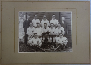
Photograph, Kew Baseball Club, c.1927
The Victorian Baseball League was established in 1889 with the following clubs - MCC, Metropolitan, Richmond, Richmond Cricketers, Kew, Geelong, Fitzroy, The Age, Carlton, Coburg. MCC defeated Metropolitan for the first Premiership. By 1897 Kew had built up to six teams, but went into recess about the turn of the century. They reformed c.1906 and did not resume until 1926 under Captain/Coach Frank Littlefield. I think he was ex Hawthorn Baseball and/or Cricket club(s). They won the D Grade Premiership of 1926 and/or 1927 playing out of Victoria Park at 12 noon, and as a curtain raiser to either Kew or Kew District or East Kew Football Club and after World War 2, North Kew which had now joined Kew as a tenant. Team members were H.L. Barclay (ex Richmond), A. Brierley (ex Collingwood), H. Ely (ex Essendon), Frank Littlefield, J. Marshall and C. Robinson (ex Hawthorn-East Melb Cricket Club). In 1926, the KBC played against Caulfield, Fairfield, Fitzroy, Ivanhoe, Northcote, Prahran, University, Williamstown, YMCA. In 1927, Preston replaced Fairfield. A third team was formed post WW2 which played at Willsmere Park. The Reserves followed to Willsmere Park in 1963 and the Seniors in c.1970. Kew Council moved the club to a sub-standard Stradbroke Park No 2 Oval for the 1976 season and this proved to be the last for the club. Melbourne Baseball Club moved in for two seasons, but also moved when improvements to No 2 Oval were not made. They then moved to Macleay Park in a share arrangement with North Balwyn BC. Research: Ian JobTeam photo of the Kew Baseball Club players and club officials and or supporters. The grandfather of the donor, Christopher Robinson has been identified as sitting in the middle row, 2nd from left.kew baseball club, victoria park -
 Kew Historical Society Inc
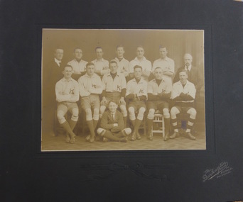
Photograph, The Burlington Studios, Kew Baseball Club, c. 1926
The Victorian Baseball League was established in 1889 with the following clubs - MCC, Metropolitan, Richmond, Richmond Cricketers, Kew, Geelong, Fitzroy, The Age, Carlton, Coburg. MCC defeated Metropolitan for the first Premiership. By 1897 Kew had built up to six teams, but went into recess about the turn of the century. They reformed c.1906 and did not resume until 1926 under Captain/Coach Frank Littlefield. I think he was ex Hawthorn Baseball and/or Cricket club(s). They won the D Grade Premiership of 1926 and/or 1927 playing out of Victoria Park at 12 noon, and as a curtain raiser to either Kew or Kew District or East Kew Football Club and after World War 2, North Kew which had now joined Kew as a tenant. Team members were H.L. Barclay (ex Richmond), A. Brierley (ex Collingwood), H. Ely (ex Essendon), Frank Littlefield, J. Marshall and C. Robinson (ex Hawthorn-East Melb Cricket Club). In 1926, the KBC played against Caulfield, Fairfield, Fitzroy, Ivanhoe, Northcote, Prahran, University, Williamstown, YMCA. In 1927, Preston replaced Fairfield. A third team was formed post WW2 which played at Willsmere Park. The Reserves followed to Willsmere Park in 1963 and the Seniors in c.1970. Kew Council moved the club to a sub-standard Stradbroke Park No 2 Oval for the 1976 season and this proved to be the last for the club. Melbourne Baseball Club moved in for two seasons, but also moved when improvements to No 2 Oval were not made. They then moved to Macleay Park in a share arrangement with North Balwyn BC. Research: Ian JobTeam photo of the Kew Baseball Club players and club officials and or supporters. The grandfather of the donor, Christopher Robinson has been identified as sitting in the back row, 2nd from left.kew baseball club, victoria park, christopher robinson -
 Orbost & District Historical Society
black and white photographs, 1980s? (winter months)
All photographs seem to have been takenfrom the Telecom tower on the corner of Browning and Wolseley Streets in Orbost 3259.1 is a view of the Orbost township looking north-east. The swimming pool and bowling club can be seen in the foreground. 3259.2 is aview looking north-west and showing the tennis courts and clubhouse, the Recreation Reserve oval, the Youth Centre, Historical Museum, Municipal Offices, Senior Citizens clubrooms with the fire station in the foreground. 3259.3 is a view looking south with the Shire of Orbost Municipal offices and Ruskin Street in the foreground. Munro Street can be seen running from Ruskin Street to St Joseph's School in the middle distance. Lochiel Park oval, Lochiel House, the Snowy River and highway bridge are in the background. 3259.4 is a view looking south showing the Club Hotel, C.B.C. Bank in the middle distance and Hoffman's paddock (Forest Park) and the Snowy River beyond. 3259.5 is a view looking north-east over houses. 3259.6 is aview over the main street, Nicholson Street.showing the main shopping precinct. Shop signs for Permewans, Williams Shoes, F.B. Dicken and Orbost Bakery can be seen. 3259.7 is a view looking south west and shows Forest park and beyond towards Bete Bolong.These photographs are detailed pictorial records of the township of Orbost.Seven black / white photographs taken from above a township. Chimney smoke can be seen in the photographs.orbost-township-1980s aerial-photograph-orbost -
 Bendigo Historical Society Inc.
Postcard - BENDIGO POSTCARDS x 5
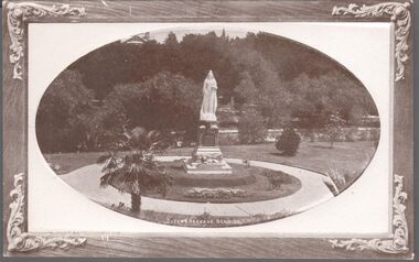
Five sepia postcards of Bendigo - St. Paul's Church, Bendigo; Queen's Reserve, Bendigo; St. Andrew's Presbyterian Church and School, Bendigo; The Orphanage, Bendigo; and Conservatory Gardens, Bendigo. 'C & L Series' and 'Semco Series', Bendigo. Early 1900's. Unused, and no writing on the reverse of the postcards. May have been connected with the Waterworth family. St. Paul's Church: St Paul's Cathedral, Bendigo was built in stages. The nave was built in 1868, the tower in 1872-73 and the transepts and sanctuary in 1926-27. Robert Love was the architect, although the final stage was supervised by architects Gawler and Drummond. Cathedral status was transferred from the original cathedral All Saints to St Paul's in 1981. The Gothic style cathedral is constructed of red brick with stone dressings. It has a simple cruciform plan comprising a six bay nave, transepts and sanctuary. A tall tower centrally located at the west end dominates the exterior. The peal of eight bells was cast by Meares and Co of London and installed in 1873. The interior features elaborately cusped roof principals; an organ by Alfred Fuller built in 1883 with a console and pipes added later from St Andrew's Cathedral, Sydney; and notable stained glass by Ferguson, Urie and Lyon. St Paul's Rectory was built in 1885 to a design by the architect W C Vahland. The Parish Office and Hall was built as a Sunday School in 1898 to a design by F W Lehmann. Queen's Reserve: Now known as part of the Bendigo Botanic Gardens, Rosalind Park, Pall Mall. In 1851, the gold rush transformed the area and eventually the mullock heaps became the most prominent public park in Bendigo. Rosalind Park was added to the Victorian Heritage Register in 2000 for its historic, archaeological, aesthetic, scientific (botanical) and architectural significance to the state of Victoria. The statue of Queen Victoria dates to 1903. St. Andrew's Presbyterian Church: Opened in 1859 as part of the Presbyterian Church, St. Andrew's. Union of the Presbyterian, Methodist and Congregational Churches in 1977 saw this church join the Uniting Church. Located in Myers Street, Bendigo. The Orphanage: The Convent of the Good Shepherd, Bendigo was established in 1905. It was established at the request of the Bishop to cater for children in the diocese of Bendigo (although it housed children from other areas as well). It was also known as St Aidan’s Orphanage, and was the only Good Shepherd Convent in Australia to care for boys. The section named St Aidan’s accommodated girls aged up to around 16 years, as well as boys aged up to around 11. Maryfields housed girls and women aged from around 15 years. The Convent ceased to operate as a residential facility for children in 1981. A number of women with disabilities remained at the Convent until it closed in 1984. Conservatory Gardens: Now known as part of the Bendigo Botanic Gardens, Rosalind Park, Pall Mall. In 1851, the gold rush transformed the area and eventually the mullock heaps became the most prominent public park in Bendigo. Rosalind Park was added to the Victorian Heritage Register in 2000 for its historic, archaeological, aesthetic, scientific (botanical) and architectural significance to the state of Victoria. The Conservatory Gardens feature an ornate 19th century Conservatory building, erected in 1897 - this was the last building of its type in a public park in Victoria. bendigo, gardens, buildings, chinese, church -
 Kew Historical Society Inc
Album - Scrapbook, Eva Grant, Historic Buildings, Kew, 1958-78, 1970s
One of three scrapbooks of photographs and newspaper cuttings taken and or collected by Eva Grant, a past member of the Kew Historical Society, which were donated by her niece, Julie Thomson. The albums include many photographs of Kew from the 1950s to the 1970s. Buildings included in the scrapbook include: Billy Hughes' house - 167 Cotham Road Congregational Church - Walpole Street (c.1978) Country Roads Board - Denmark Street (1960) Dorothy Rogers Reserve - Studley Park Road Ellsmere (also Ellesmere/Ellsmore) - Princess Street Field Place - 3 Henty Court Fernhurst - 13 Fernhurst Grove Kew Civic Centre (1959) Kew Junction (1958) Kew Railway Station (1902, 1959) Kew Recreation Hall - Wellington Street (1960) Neama (Hall) - Studley Park Road Southesk (formerly Ordsall) - Cotham Road (c.1960) St Anthony's Home for Babies (formerly Madford) - 43 Wellington Street (c.1976) Studley House - Nolan AvenueThe scrapbook contains historically significant, rare and sometimes unique images of significant heritage buildings in Kew, including their erection and demolition. 11-page scrapbook of photographs and newspaper clippings with annotations by Eva Grant, a past member of the Kew Historical Society. The pages of the album can be viewed in the image carousel above. Based on the text and known dates of demolition of a number of the buildings, the scrapbook was assembled over a twenty year period between c.1958-c.1978.Includes letter from donoreva grant, billy hughes' house - 167 cotham road, congregational church - walpole street - kew, country roads board - denmark street - kew, dorothy rogers reserve - studley park road - kew, field place - 3 henty court - kew (vic), ellsmere (also ellesmere/ellsmore) - princess street - kew, fernhurst - 13 fernhurst grove - kew (vic), kew civic centre - civic drive - kew (vic), kew junction - kew (vic), kew railway station - denmark street - kew (vic), recreation hall - wellington street - kew, neama - hall - studley park road - kew (vic), southesk - ordsall - cotham road- kew (vic), st anthony's home for babies - madford - 43 wellington street (vic), studley house - nolan avenue - kew (vic) -
 Kew Historical Society Inc
Photograph - Entrance to Boroondara General Cemetery
Boroondara Cemetery, established in 1858, is within an unusual triangular reserve bounded by High Street, Park Hill Road and Victoria Park, Kew. The caretaker's lodge and administrative office (1860 designed by Charles Vickers, additions, 1866-1899 by Albert Purchas) form a picturesque two-storey brick structure with a slate roof and clock tower. A rotunda or shelter (1890, Albert Purchas) is located in the centre of the cemetery: this has an octagonal hipped roof with fish scale slates and a decorative brick base with a tessellated floor and timber seating. The cemetery is surrounded by a 2.7 metre high ornamental red brick wall (1895-96, Albert Purchas) with some sections of vertical iron palisades between brick pillars. Albert Purchas was a prominent Melbourne architect who was the Secretary of the Melbourne General Cemetery from 1852 to 1907 and Chairman of the Boroondara Cemetery Board of Trustees from 1867 to 1909. He made a significant contribution to the design of the Boroondara Cemetery. (Source: Heritage Victoria)This photograph is one of the earliest known photographs of the cemetery, showing the early plantings and fences.Later print copy of an undated original photographic positive of the entrance to the Boroondara General (Kew) Cemetery. The Cemetery had been opened in 1855. This view is from Bulleen Road (now High Street) showing a group of 12 or 13 men standing in a line outside the entrance. At this time, the clocktower and high brick fence had not been constructed, but the trees have reached a substantial heightPencil inscription on reverse - "Boroondara Cemetery Entrance 1862"boroondara general (kew) cemetery, cemeteries -- melbourne (vic.) -
 Sunbury Family History and Heritage Society Inc.
Photograph, Lamgama Park - Soccer Pitch, C 1970s
Sunbury United Soccer Club was established in 1973 by a group of expatriate Europeans who wanted to play the game they grew up with. Their first games were played on the recreation reserve in Evans Street on the ground designed for AFL football. (Now the site of a shopping complex). In August 1975, Sunbury United moved to its present home on seven and a half acres of sporting ground at Langama Park in Mitchells Lane . Over the years that area has developed and there are now three senior, and two junior soccer pitches with two cricket pitches and practice nets. Although there is still room for improvement to the floodlighting on the main pitch, the night games have proven successful. The Sunbury United Soccer Club has played an important roll in district competition and is one of the many sporting clubs in Sunbury.A non-digital black and white photograph of a soccer ground showing a set of goal posts with the clubrooms and change rooms in the background.soccer, sunbury united soccer club, football, langama park, mitchells lane -
 Surrey Hills Historical Society Collection
Work on paper - Vertical file, Beckett Park and Maranoa Gardens
1. ‘Observation tower Beckett Park’, B.H. Reporter, 23.11.1934 (2 pages). 2. ‘Glory of a native garden’, F. Chapman, Literary Section unknown paper, 2.9.1939 (1 page, 2 copies original and copy). 3. Copy ‘Centenary tower’, The Herald, 21.5.1937 (1 page). 4. ‘Maranoa’, Camberwell City News, August, 1990 (1 page). 5. ‘Rotary Club’s gift to garden’, ? Age, 1990s ? (1 page) 6. ‘Maranoa Gardens & Beckett Park’ supplement, Boroondara Bulletin, 1997 (2 page spread). 7. ‘Beckett Park revisited’ by Annie Gillison, 8.7.1985, Melbourne Week ? (1 page). 8. Maranoa gardens Boroondara Council brochure (undated) (1 page). 9. Re Mr. Arthur J. Swaby, information from various sources, undated (1 page). 10. Beckett Park – ‘Glory of a Native Garden’, F. Chapman, unnamed newspaper, 2.9.1939, copy. (1 page). 11. Beckett Park: information re Robert Beckett from various sources (2 pages). 12. ‘Most will like gardens plan’, unnamed newspaper, letter from Dennis Whelan, undated (1 page). 13. Extracts from J.A. Allan’s unpublished history of Camberwell re Beckett Park & Maranoa Gardens, undated (1 page). 14. Maranoa Gardens Self-guided walk, undated (4 page brochure). 15. Notes on F. Chapman and interests, various sources, (2 pages). 16. Empire Day celebrations, extract from Argus, 24.5.1937 (1 page). 17. Extract from Camberwell Conservation Plan, 1989 by McConville (1 page). 18. ‘A lesson in serenity’, Maranoa Botanic Gardens, Balwyn, Domain Review, 7.7.2021 (2 pages). 19. Boroondara City Council Notice of proposed naming of reserve, Progress Leader, 5.12.2019 (1 page). 20. Maranoa Botanic Gardens, undated (double sided pamphlet). 21. 2 extracts from Box Hill Recorder, 23.10.1925 and 27.11.1925 (1 page). 22. Extract from BHR, 15.1.1926 ‘Visit of Field Naturalists Club of Victoria’ (1 page). -
 Glen Eira Historical Society
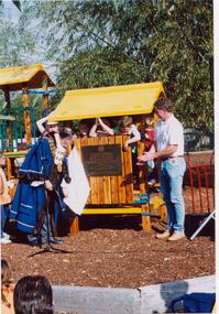
Letter - Halley Park
... Parks ...This file contains three items. A letter to Ms Wendy A. Ross from Hazel Ford, secretary of the Glen Eira Historical Society, dated 31/05/2002. A letter to Felicitie Camplbell from Wendy A. Ross dated 07/05/2002, along with three photographs which were enclosed with the letter, including two of Mayor of Moorabbin, Cr. R. J. Bob Flavell, opening the playground at Halley Park, and one of a plaque. Three photographs including two of Halley Park Opening Ceremony where the Mayor of Moorabbin opened the playground at Halley Park which was the winner of the COMMUNITY PROJECT OF THE YEAR 1994 award, and one of the plaque commemorating the organisations that developed the park, photographs taken on 01/05/1994.ross wendy a., campbell felicitie, moorabbin, bentleigh, marquis road bentleigh, halley park, glen eira historical society, ford hazel, flavell r. j. cr., flavell bob cr., jasper road bentleigh, mortimore street bentleigh, playgrounds, parks, reserves, friends of halley park inc., community project of the year, apex club, playground equipment, children’s playgrounds, gardens, recreations establishments, healthy hearts local government state awards 1994, plaques -
 Wodonga & District Historical Society Inc
Photograph - Opening of Wodonga Band Rotunda, 1920
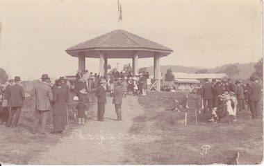
The Band Rotunda was officially opened on Sunday 5th September 1920 at the naming of the triangular reserve as Woodland Grove at the corner of High and Hovell Streets. The Wodonga Band gave a public performance on this occasion. The tri-coloured ribbon, which stretched across the entrance to the Rotunda was cut by Mrs R. H. Murphy, daughter of Mr John Woodland, Secretary of the Wodonga Shire Council for 35 years, after whom the area was named. The rotunda has since been moved to Martin Park, Wodonga. This image is one of a collection of photos taken by Robert Prentice. The images are clearly identified as he inscribed in the glass a back-to-front capital R (Я) on to which was joined a capital P creating his mark ЯР.These images are significant as they record an important event in the history of Wodonga.Two black and white images showing people gathered for the opening of the new band rotunda in Wodonga in 1920.On photos Wodonga Initials ЯР wodonga band rotunda, wodonga band, robert prentice -
 Eltham District Historical Society Inc
Album - Photograph, J.A. McDonald, Eltham-Diamond Creek Road, 21 Oct. 1953
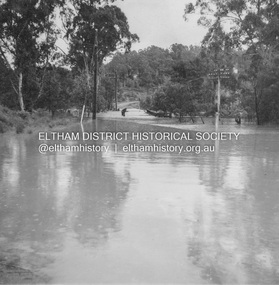
18 October 1956 Flood level on road at corner of Railway Parade. On the immediate left out of view is Mrs Lucy Egan's home. That house still stands today nestled up against the Wattletree Road Bridge on the other side built in 1959 and is owned by the Bakos family purchased by Mrs Heather Bakos in 1960.. Prior to the Wattletree Road bridge being built, Railway Parade extended up the alignment of present-day Gastons Road to the Eltham-Diamond Creek road which ran past the entrance of the present-day carpark for Edendale Farm. This view is looking west across the Glen Park Bridge, and the beginning of Wattletree Road which sweeps around to the right in the distance. Progress Road does not exist though a road reserve is present on maps.Record of various Shire of Eltham infrastructure works undertaken during the period of 1952-1962 involving bridge and road reconstruction projects, sometimes with Eltham Shire Council Project Reference numbers quoted. It was during this period that a number of significant improvements were made to roads and new bridges constructed within the shire that remain in place as of present day (2022). In many situations, the photos provide a tangible visible record of infrastructure that existed throughout the early days of the Shire. The album was put together by or under the direction of the Shire Engineer, J.A. McDonald.infrastructure, road construction, shire of eltham, bridge construction, eltham north, floods, floodwater, glen park bridge, 1956-10-18, diamond creek (creek), eltham, railway parade, wattletree road, wattletree road bridge, gastons road -
 Eltham District Historical Society Inc
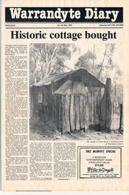
Folder, Warrandyte Miner's Cottage, 1984
Report and photograph about purchase of historically significant slab cottage in Castle Road, Warrandyte. Newspaper also includes articles relating to Jock Macneish and his ultra-light aircraft, construction of foot bridge over Andersons Creek, Mrs Ruth Norman, Warrandyte Co-op, local results of the 1981 census, construction of elderly citizens' flats in Stiggant Street (Warrandyte), South Warrandyte Primary School, Professor's Hill and Warrandyte Football Club. The road guide features advertisments for Inglenook Tea Rooms, Warrandyte, Warrandyte Recreation Reserve Cafe (Mrs C. Miller, Proprietress), Eltham Motor Garage, Plaza Cafe Eltham, Eltham Park Team Rooms, Diamond Creek Garage and Engineering Works and The Dean Guesthouse Strathewen.Complete issue of "Warrandyte Diary" No 145, May 1984 with feature article headed "Historic cottage bought". 12 pages with section cut out of back page. Also includes photocopy of Broadbents Roadguide: central Victoria, 1946 pages 230-231HG Booklet 281981 census, advertisment, andersons creek, castle road, diamond creek garage and engineering works, eltham motor garage, eltham park team rooms, footbridge, harry gilham collection, inglenook tea rooms, jock macneish, mrs c. miller, mrs ruth norman, plaza cafe eltham, professor's hill, senior citizens, south warrandyte primary school, stiggant street, the dean guesthouse strathewen, warrandyte, warrandyte co-op, warrandyte football club, warrandyte recreation reserve cafe, warrandyte slab cottage -
 Eltham District Historical Society Inc
Book, Jenny Brown et al, Out of the Mist; Osborne Peninsula, 2024
The Osborne Peninsula on the Yarra River at Warrandyte accommodates a limited number of properties and residents (70 households). The area is rich in geology and ecology, and an unusually rich endowment of human, built and creative history. Contents: Welcome: The landform: The River: Aboriginal occupation: The Miners: North Warrandyte :The Subdivision: The Lowes: The Osbornes: The Last Osborne: The Elders: The Relics: Dray Track: Water Wheel"Kauri Plaque: River track: Pines: Windmill Creek Bridge: The Koornong School: The Houses" Man Cave: MidCentury Classic: Enduring Original" Masterwork: The Muddies: The State Park: The Saving of Koornong Reserve: The Landcare Story: Flora and Fauna: The Vulnerable, Endangered and threatened: Birds: Mammals: "Waring" the wombat: Reptiles: Fish: Invertebrates: Flora: Fire. Published by the North Warrandyte (Osborne Peninsula) Landcare Group. Includes photos from EDHS collection.64 p. : ill., map ; 29.7 x 21 cm. (2 copies)yarra river, birrarung, dray track, fauna, geology, houses, indigenous history, koornong reserve, koornong school, lowe family, mining, mudbrick houses, north warrandyte, osborne family, warrandyte state park, water wheel, north warrandyte (osborne peninsula) landcare group, osborne peninsula -
 Bendigo Historical Society Inc.
Document - LONG GULLY HISTORY GROUP COLLECTION: COMMUNITY GARDENS IN LONG GULLY
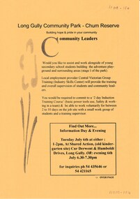
An invitation to a Community gathering - walk around the grounds of the House and future family park (Chum Reserve) & look at ideas and plans people have for starting a basic food producing, interesting gardens at the Long Gully Community House. Community people have been meeting over a few meetings to look at ideas to start a community garden in Long Gully. Some ideas are mentioned. Over the page is An Information Day & Evening at Shared Action re assisting and working alongside young secondary school students building the adventure playground and surrounding areas. Central Victorian Group Training (Industry Skills Center) will provide training and overall supervision of students and community leaders. A 2 day Induction Training Course and be able to work voluntarily for between 2 to 10 days on the job site with a small work group is required.bendigo, history, long gully history group, the long gully history group - community gardens in long gully, chum reserve, long gully community house, central victorian group training (industry skills center) -
 Bendigo Historical Society Inc.
Document - NOTES FOR RHSV BENDIGO BRANCH NEWSLETTER ''BENDIGO MEMORIES, 1860 TO 80''
Notes for Aug. 1973 RHSV Bendigo Branch Newsletter ''Bendigo Memories, 1860 -80'' by G Meudell, author of ''The pleasant reflections of a spend thrift and his later reflections'', article submitted by Mr R Buick - continuation of this article in the Nov 1973 issue (see Mosaic #6544) - reference to George Lansell; Baranet Lazarus; William Hunter; Joseph Hunter; Robert Hunter; Burnewang Park; William Moffat; Andrew O'Keefe; David Grant; Thomas Luxton; James Vickery; James Taylor; Jim Maddox; Cocky Brown (caretaker of Camp Reserve); W D C Donovan; Eureka Stockade. 2. Article entitled ''Looking Back'' by Joch - re Historical Societies of Bendigo - mention of a long list of Bendigo names involved with the early Society and a call for readers of the article to research and record the History of Bendigo!!!document, names of bendigo pioneers, bendigo -
City of Kingston
Photograph - Colour, 6 March 1993
Edithvale is a suburb in the City of Kingston. It is located between Aspendale and Chelsea on the Port Phillip Bay and built within remnant areas of the Carrum Carrum swamp. The foreshore precinct comprises a wide sandy beach, with low sand dunes and numerous historic boat sheds. The suburb consists of older style dwellings and former holiday houses, combined with mid-century housing and newer homes. The large blocks are increasingly subdivided and the existing dwellings demolished to accommodate units and townhouses, thus changing the landscape of the area and reducing the tree canopy.The beachside suburb of Edithvale was previously part of the extensive Carrum Carrum Swamp. The area was once a source of fish and eels for the Mayone-Bulluk clan of the Bunurong people. Over time the area was drained and predominantly devoted to dairy farming and holiday houses. The farms were gradually sold and subdivided with a large number of homes built after World War II and in the 1960s. Edithvale is mainly residential with a shopping strip along Nepean Highway but little significant industry was ever established in the area apart from a plaster works and confectionary factory, both now closed.Laminated aerial colour photograph of Edithvale as viewed from Alexandra Avenue in the north to Ella Grove Chelsea/Edithvale in the south. regents Park Aspendale can be seen in the top left. The area is built-up with residential housing and facilities including Edithvale Primary School, numerous churches and the Edithvale Railway station. Large sections depict the remnant Carrum Carrum swamp. Edithvale Common and the former "Duck Inn" (Melbourne Water/Friends of Edithvale Seaford Wetlands) can be seen. Edithvale Recreational reserve, the valodrome and Edithvale Public Golf Course are prominent. The image shows vacant land in the area now known as Aspendale Gardens and the newer residential section of Chelsea Heights is not developed. A bike path has been established to cover the secondary drain. The Golf Links Court residential development located off Hughes Avenue is a large vacant block.Black type on white adhesive label: 6-3-93 Black type on white adhesive label: 25/9211, 6/3/93, 11.20 am Black type on white adhesive label: 9211 Yellow circular adhesive sticker Black pencil: 9211 6-3-93 arrow pointing Nedthvale, carrum carrum swamp, aspendale, chelsea -
 Bendigo Historical Society Inc.
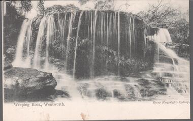
Postcard - Australia, Elliot Collection, 1895 - 1914
Thought to have originated in Austria in 1869, postcards first gained popularity in Australia in the 1890s.They were used to send short messages to friends and family. This collection was generated by Mary Emma Elliot of Talgarno. Talgarno is a rural locality in Victoria, Australia, situated on the southern shoreline of Lake Hume, about 23 km east of Albury-Wodonga. The collection contains postcards from across the world. Mary Emma Sibley was born in Ironbark, Bendigo in 1859. She married James Elliot in 1893 and they settled at “Kelso”, Talgarno. They had two children – Mona and Sibley. Mary Emma Elliot died in Melbourne in 1944, aged 84 years. Australian postcards collected by Mrs. James Elliot between 1898 and 1915. 1405.041 weeping Rock, Sydney 1405.042 Railway Yards, Newcastle 1405.043 Botanic Gardens, Sydney, N.S.W. 1405.044 Mullet Creek, Dapto 1405.045 The Corso, Manly, Sydney 1405.046 The Gap Watson's Bay, Sydney 1405.047 Hyam Pass, Showgrounds Reserve, Nowra 1405.048 Newcastle N.S.W., "Nobby's". 1405.049 Commonwealth Bank of Australia, Sydney 1405.050 Beach, Stanwell Park 1405.051 Stroud Cutting 1405.052 The Derwent River, Tasmania 1405.053 Hume Bridge and Cooma St., Yass 1405.054 Yass River 1405.055 The Fernery, Blackheath, Blue Mountains 1405.056 Yass River at Kenilworth 1405.057 Hawkesbury River 1405.058 Market Street, Sydney 1405.059 Georges St. from Margaret St., Sydney 1405.060 'Neath Southern Skiespostcards, collecting, collections, talgarno