Showing 353 items matching "planning officer"
-
 Ambulance Victoria Museum
Magneto Crank TelephoneTelephone, Early 20th centry
Probably from regional station or regional station officer's house for after hours call outs. Possibly from suburban station officer's house. Source Chas Martin AHSV curator. label on telephone states that this was a spare disaster plan (displan) magneto telephone. Other details on label.Black telephone with wind up handle in front centre. Batteries behindTO CALL TURN HANDLE & KIFT HANDSETcommunications, disaster -
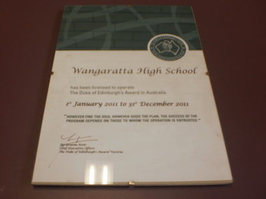 Wangaratta High School
WHS Framed Certificate, 2011
White certificate with a green section at the top and a round green Duke of Edinburgh symbol in the top right. Maroon and green text reads:Wangaratta High School has been licensed to operate The Duke of Edinburgh's Award in Australia 1st January 2011 to 31st December 2011 "HOWEVER FINE THE IDEA, HOWEVER GOOD THE PLAN, THE SUCCESS OF THE PROGRAM DEPENDS ON THOSE WHOM THE OPERATION IS ENTRUSTED." Mr Graeme Kent Chief Executive Officer The duke of Edinburgh's Award Victoria -
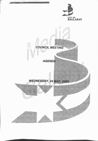 Ballarat Tramway Museum
Document - Report, City of Ballaarat, "Ballarat City Tram Study", May. 2000
Twenty Six sheet document pertaining to the reinstatement of trams to Ballarat, presented to the Ballarat City Council on Wed. 24 May 2000. Details are: Sheets 1 to 3 - Cover and contents sheets for the Council Meeting of 24/5/2000 containing the Agenda, Ballarat City logo on white A4 paper. Sheet 4 - pages 37 and 38 of the Agenda, Officers report on the study work carried out, noting the Ballarat Tourism Board work, giving a summary, background, issues, options, financial implications, attachments and recommendation. On a white sheet of A4 paper. Sheets 5 - 26 - on green A4 paper - document titled "Ballarat Tourist Tram Study", final report dated August 1999, though not received by the Ballarat Tourism Board until March 2000. Written by G.D. Harrison Project Management Pty Ltd. Report looks at the marketing aspects, planning, infrastructure, staffing, ticketing and financial analysis, map of suggested route and comparative operations elsewhere.trams, tramways, ballarat city tramway, ballarat revival, harrison report, city of ballarat -
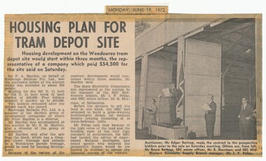 Ballarat Tramway Museum
Newspaper, The Courier Ballarat, "Housing plan for tram depot site", 19/06/1972 12:00:00 AM
Newspaper clipping from The Courier, Ballarat, dated Monday, June 19, 1972 titled "Housing plan for tram depot site". Reports on the sale of the former tram depot on Saturday June 17 for $54,500. The purchaser expected to start development of housing on the site within three months. Reports on the sale, purchaser and SEC's views. Features a photo of Edgar Bartrop reading the contract. Others in the photo are Bruce Bartrop, SEC Estate officer, Mr. R. Morrison and SEC Manager Mr. I. F. Pellas. One of a large group of newspaper cuttings from John Bainbridge, 7/4/02.depot, buildings, auctions, bartrop -
 Bendigo Historical Society Inc.
Document - MERLE HALL COLLECTION: CORRESPONDENCE AND DOCUMENTATION RE SITE FOR PERFORMING ARTS CENTRE 1975/76
a. Extensive and detailed correspondence and documentation re site for Performing Arts Centre 1975/76; Letters from City Engineers; Town Clerk; Dr Westbrook (Ministry for the Arts); Drama officer (Ministry for the Arts); includes list in of Arts Council sponsored performances over the period 1971-1975; questionnaire relating to a Cultural & Arts Centre; list of Potential Users of an Art Centre Complex; minutes/correspondence re The Bendigo Urban Renewal Liaison Committee; plans for sites. Would need to be read and examined in its entirety due to complexity of the issue; b. Correspondence between City of Bendigo and Bendigo Arts Council (April 1976); Correspondence between City of Bendigo and Arts Council of Australia (Feb/Mar 1974) with Valuer's Letter and handwritten notes of sub-committee meeting. -
 Bendigo Historical Society Inc.
Plan - SANDHURST BOYS CENTRE COLLECTION: SANDHURST TRAINING CENTRE ADMINISTRATION BUILDING FLOOR PLAN
Photocopy of the Administration building floor plan, showing Clinic, switch room, store, sick ward with patients toilet, utility and cleaners rooms, nurses station, pantry, doctors office, waiting room, locker rooms, reception foyer, general office, offices for chief training officer and secretary. Location unknown 16.02.2023.bendigo, institutions, sandhurst boys centre, victoria. ministry of housing and construction; sandhurst training centre; floor plan - administration building; -
 Bendigo Historical Society Inc.
Document - MERLE HALL COLLECTION: VARIOUS DOCUMENTS RELATED TO A ''REGIONAL CENTRE FOR THE PERFORMING ARTS''
Various combined documents related to a regional Centre for the Performing Arts - comprises Draft letter from ''Bendigo Branch of A.C.A.'' sent to all councillors of Bendigo, Huntly, Marong, Strathfieldsaye, Bendigo Trust and Members of Parliament (with handwritten annotations/unsigned); Notes on the Arts Council Theatre Project (''this office has been engaged on this project since June 1972 and working on the proposal to use the present site since September 1973'' (with handwritten annotations); ''Thoughts of Robert Herriot and Jack Cannon about the possibility of engaging a Community Arts Promotion Officer for Bendigo'' (with handwritten annotation from Bob H referring to''tape made in the car in Canberra 2/8/74''; City of Bendigo - Consultants Brief in connection with the preparation of a report of own Planning problems and solutions in the central business area of the City of Bendigo (''submissions in accordance with this brief by 30th April 1974''). -
Bendigo Historical Society Inc.
Document - MERLE HALL COLLECTION: ROSALIND PARK CREATIVE VILLAGE BENDIGO PROJECT AND FINAL REPORTS, 1995
MERLE HALL COLLECTION: ROSALIND PARK CREATIVE VILLAGE BENDIGO Project and Final Reports 3858.13 PDF File 11th August 1997 - three pages From: Merle Hall, Secretary Arts Bendigo To: Mike (final Media Release probably the Bendigo Advertiser) Content: Media Release two pages and a poem read out by Mosaic Artist Maery Gabriel (Hall) 'Reflections from Rosalind Park' Date Unknown: First invitation mail-out for C.V.T. Presentation and notes. Invitations to Felicity Kingerlee, Rod, Orr, Jane Cleary, Ian Stewart (Flora Hill Secondary College), Marion Stewart (White Hills Secondary College), Marion Wright, G. Maddams (& staff), Frank Ham, Tony Morris (Astronomy chap), Trevor Tonking (Cont. Ed.), Bernard smith and others at City of Bendigo, All A.B. Committee. Included are handwritten notes. Date Unknown: Two page document entitled: Enhancing the livable environment. Document contains details of the project, aims etc. 14th March 1995 To: The Greater City of Bendigo From Arts Bendigo Content: Two pages, a formal proposal for the involvement of the City of Greater Bendigo in the Creative Village project of the V.A.C. It contains information on Background, Concept,Implementation,Expected outcomes, Summary, Appendix 1 and 2 (Examples of the work of the artist). Date Unknown From John L. Content: one page of notes on similar projects and involvement by Arts Bendigo. The title of the document is Creative Village - Enhancing the Livable Environment. 5th Septemberh 1995 To: Members of the community who contributed ideas and suggestions From Arts Bendigo Ann Buzza and Merle Hall. Content: Invitation to attend a meeting with the Creative Village Team to view the Team's full report and explanation of designs etc. 9-10 June To: Participants in the Maery Hall Workshop From Arts Bendigo Ann Buzza and Merle Hall. Content: Location - ceramic department, Fine Arts building, Latrobe University Bendigo; acces information and what to bring to the workshop. Date Unknown To: City of Greater Bendigo Content: Arts Bendigo committment to the guidelines discussed with the relevent Council officers. Date Unknown To: City of Greater Bendigo From Arts Bendigo Content: Title - Historic Mining Mosaic Pavement at rosalind Park Poppet Head. A report on the project so far. Typed and ewritten notes. 28 July To: Public From Arts Bendigo Merle Hall. Content: Public invite to mark the completion of the project. June 1997 To: Public Content: A copy of Bendigo Heritage Mosaic City of Greater Bendigo plaque. 2nd September To: Attention Leanne McDonnell, Bendigo Advertiser From Arts Bendigo Merle Hall. Content: Media Release on 'The Laying Begins' Date Unknown To: Potential Donors From Arts Bendigo Merle Hall, sponsorship committee. Content: Description of the project titled 'Exciting Addition to Bendigo's Central Area. Date Unknown To: Potential Donors From Arts Bendigo Merle Hall, sponsorship committee. Content: Description of the project titled 'Exciting Addition to Bendigo's Central Area. Date Unknown List of LEAP team members for the project. Date Unknown To: Emma Power From Arts Bendigo Secretary Merle Hall. Content: three pages of information on the project (1. Intoduction 2. Small leaflet, prepared for visitors to the team 3. General outline of the project and the background on the Creative Village Team. 19-21 July To: All schools of the Bendigo area From: Merle Hall Secretary Arts Bendigo Content: An invitation for staff and students to visit the Creative Village Team during their time in Bendigo, at the Central Library on 19-21 July 19-21 July To: The Public From: Merle Hall Secretary Arts Bendigo Content: An invitation for staff and students to visit the Creative Village Team during their time in Bendigo, at the Central Library on 19-21 July 5th October 1995 To: Mr Peter Seamer, Chief Executive Officer, City of Greater Bendigo. From Merle Hall Secretary Arts Bendigo Content: RE 'Creative village team report and ongoing plans' 14 March 1996 To: Committee of Arts Bendigo From: Ann Buzza Content: Two pages hand-written report on visit of Maery Hall ot Bendigo 14/3/96 Date Unknown To: Bernard Smith, City ogf Greater Bendigo From: Merle Hall, Secretary Arts Bendigo Content: A list of urgent requirements needed by May 24th, material list from council stock. 27 June 1996 To: The Professionals, 54 Mitchell Street Bendigo, Attention Stephen Carter From: Merle Hall, Secretary Arts Bendigo Content: Account for use of shop in Allan's walk and cheque. 2nd July 1996 To: Cr Megan Weston Mayor, city of Greater Bendigo, copy to Bernard Smith. From: Merle Hall, Secretary Arts Bendigo Content: Thank you for $3500 to match the Arts Bendigo sponsorship. 2 June 1996 To: James C donnelly and associates, 5 School Lane, Wangi Wangi. From: Merle Hall, Secretary Arts Bendigo Content: Draft cover letter including a one page draft letter and a two page submission. James Donnelly was a parent of one of the LEAP workers who were helping on the project. James donnelly had suggestions for approaching mining companys for potential sponsorship. 1st October 1996 To: Mr D. Goldsworthy, City of Greater Bendigo From: Merle Hall, Secretary Arts Bendigo Content: Historic mining Mosaic Project, Rosalind Park Poppet Head. A formal submission for the council for some essential provisions for the extension of work on this project. 1st October 1996 To: Cr M. Weston, Mayor, City of Greater Bendigo. From: Merle Hall, secretary arts Bendigo Content: Three pages including a listing of income and costs to the project. 28th October 1996 To: Arts Bendigo From: Maery Hall Artist Content: two page report on the status of the project and problems that have been faced. 19th To: Leanne (maybe the Bendigo Advertiser) From: Merle Hall, secretary arts Bendigo Content: two pages on the finished project (Bendigo's Newest attraction) 19th March 1997 To: Steve From: Merle Hall, secretary arts Bendigo Content: Asking for rough quotes for printing of brochures. Date Unknown To: The Bendigo Bank From: Merle Hall, secretary arts Bendigo Content: two pages seeking a sum of $1000 to complete the project. 28th April 1997 To: Suzi Birthisel, Sponsorship Coordinator, Bendigo bank, Fountain Court, Bendigo From: Merle Hall, secretary arts Bendigo Content: Asking for a small sum for production of coloured brochures Date Unknown To: Committee From: Merle Hall, secretary arts Bendigo Content: Suggested invitation list from 'Arts Victoria' to the Committee re the opening on 28th July of the Bendigo Heritage Mosaic. 28 July 1997 From: City of Greater Bendigo and Arts Bendigo to public Content: Invitation to a brief ceremony to mark the occasion of the completion of The Bendigo Heritage Mosaic at the Poppet Head Lookout, Rosalind Park on Monday 28 July 1997. 5th August 1999 From: Merle Hall, Secretary Arts Bendigo To: Cr. B. Ackerman, Mayor, City of Greater Bendigo. Content: A brief note from the committee of Arts Bendigo, in appreciation of your attendance and speech at the 'completion ceremony, last week. 30th October 1997 From Merle Hall, Secretary Arts Bendigo To: the National Community links Awards, Category 1 - Arts and Culture Content: Included were Nomination Form, Written Statement as required under (5), a written reference from the mayor of the City of Greater Bendigo, two pages of photographs of the project, and five copies of a brochure printed to publicise the project. 2nd Feb 1998 From Merle Hall, Secretary Arts Bendigo To: Mrs. S. Parain, President, Regional Arts Fund Content: Regional Arts Fund Application, Sections 1 to 4 requesting a grant of $5197.00 -
 Kew Historical Society Inc
Plan, Melbourne & Metropolitan Board of Works : Borough of Kew : Detail Plan No.1576, 1904
The Melbourne and Metropolitan Board of Works (MMBW) plans were produced from the 1890s to the 1950s. They were crucial to the design and development of Melbourne's sewerage and drainage system. The plans, at a scale of 40 feet to 1 inch (1:480), provide a detailed historical record of Melbourne streetscapes and environmental features. Each plan covers one or two street blocks (roughly six streets), showing details of buildings, including garden layouts and ownership boundaries, and features such as laneways, drains, bridges, parks, municipal boundaries and other prominent landmarks as they existed at the time each plan was produced. (Source: State Library of Victoria)This plan forms part of a large group of MMBW plans and maps that was donated to the Society by the Mr Poulter, City Engineer of the City of Kew in 1989. Within this collection, thirty-five hand-coloured plans, backed with linen, are of statewide significance as they include annotations that provide details of construction materials used in buildings in the first decade of the 20th century as well as additional information about land ownership and usage. The copies in the Public Record Office Victoria and the State Library of Victoria are monochrome versions which do not denote building materials so that the maps in this collection are invaluable and unique tools for researchers and heritage consultants. A number of the plans are not held in the collection of the State Library of Victoria so they have the additional attribute of rarity.Original survey plan, issued by the MMBW to a contractor with responsibility for constructing sewers in the area identified on the plan within the Borough of Kew. The plan was at some stage hand-coloured, possibly by the contractor, but more likely by officers working in the Engineering Department of the Borough and later Town, then City of Kew. The hand-coloured sections of buildings on the plan were used to denote masonry or brick constructions (pink), weatherboard constructions (yellow), and public buildings (grey). Development in the 20th century has irreparably altered that part of Kew represented in this plan. In the block bounded by Cotham Road, Charles Street, Wellington Street and Gellibrand; just one house standing in 1903 remains. This block included two of the most historic houses in Kew: ‘Ordsall’ (later ‘Southesk’) and ‘Madford’ (previously ‘Elm Lodge’). Ordsall was the home of the second chairman of Kew, John Halfey. It contained some of the most significant interior murals in Kew, created for Halfey by artists working for Cullen & Co. It was demolished in 1960 to make way for the Kew Civic Centre. Elm Lodge had been built for William Siddeley in ca. 1864. Arthur Septimus King purchased it in 1874. The lower paddocks of Madford were sold in 1905 by his wife to the Borough of Kew and, after landscaping by George and Thomas Pockett, opened as the Alexandra Gardens in 1908. Elm Lodge/Madford was in 1922 to become St. Anthony’s Home for Little Children before its subsequent demolition in the 1980s.melbourne and metropolitan board of works, detail plans, maps - borough of kew, mmbw 1576, cartography -
 Kew Historical Society Inc
Plan, Borough of Kew Detail Plan No.1577, 1904
The Melbourne and Metropolitan Board of Works (MMBW) plans were produced from the 1890s to the 1950s. They were crucial to the design and development of Melbourne's sewerage and drainage system. The plans, at a scale of 40 feet to 1 inch (1:480), provide a detailed historical record of Melbourne streetscapes and environmental features. Each plan covers one or two street blocks (roughly six streets), showing details of buildings, including garden layouts and ownership boundaries, and features such as laneways, drains, bridges, parks, municipal boundaries and other prominent landmarks as they existed at the time each plan was produced. (Source: State Library of Victoria)This plan forms part of a large group of MMBW plans and maps that was donated to the Society by the Mr Poulter, City Engineer of the City of Kew in 1989. Within this collection, thirty-five hand-coloured plans, backed with linen, are of statewide significance as they include annotations that provide details of construction materials used in buildings in the first decade of the 20th century as well as additional information about land ownership and usage. The copies in the Public Record Office Victoria and the State Library of Victoria are monochrome versions which do not denote building materials so that the maps in this collection are invaluable and unique tools for researchers and heritage consultants. A number of the plans are not held in the collection of the State Library of Victoria so they have the additional attribute of rarity.Original survey plan, issued by the MMBW to a contractor with responsibility for constructing sewers in the area identified on the plan within the Borough of Kew. The plan was at some stage hand-coloured, possibly by the contractor, but more likely by officers working in the Engineering Department of the Borough and later Town, then City of Kew. The hand-coloured sections of buildings on the plan were used to denote masonry or brick constructions (pink), weatherboard constructions (yellow), and public buildings (grey). MMBW Plan No.1577 includes some of the most significant houses in Kew: Herbert Henty’s ‘Roxeth’ (now part of Trinity Grammar), ‘Butleigh Wooton’, ‘Bokara’ and ‘Harrow’. It also includes the streets that have since changed their names. That part of College Parade linked to Glenferrie Road is now named College Place, College Parade now extends further north, and Charles Street did not yet reach Barkers Road. Roxeth is one of a number of Henty houses in Kew. Herbert Henty made his home here and was elected a member of Kew Municipal Council in 1864 and mayor in 1868-69. Walter Henry Serle, of Harrow served in the First World War. He was awarded the Military Medal ‘’For conspicuous bravery and devotion to duty. On 29th September near BELLICOURT he showed the greatest bravery and determination when his platoon was attacked by enemy bombing parties. It was due largely to his personal efforts that all the attacks were repulsed. Until wounded, his utter disregard of personal safety and boldness in dealing with the attacks were the means of saving the situation and were an inspiring example to his men.’melbourne and metropolitan board of works, detail plans, maps - borough of kew, mmbw 1577, cartography -
 Kew Historical Society Inc
Plan, Melbourne & Metropolitan Board of Works : Borough of Kew : Detail Plan No.1578, 1904
The Melbourne and Metropolitan Board of Works (MMBW) plans were produced from the 1890s to the 1950s. They were crucial to the design and development of Melbourne's sewerage and drainage system. The plans, at a scale of 40 feet to 1 inch (1:480), provide a detailed historical record of Melbourne streetscapes and environmental features. Each plan covers one or two street blocks (roughly six streets), showing details of buildings, including garden layouts and ownership boundaries, and features such as laneways, drains, bridges, parks, municipal boundaries and other prominent landmarks as they existed at the time each plan was produced. (Source: State Library of Victoria). This plan forms part of a large group of MMBW plans and maps that was donated to the Society by the Mr Poulter, City Engineer of the City of Kew in 1989. Within this collection, thirty-five hand-coloured plans, backed with linen, are of statewide significance as they include annotations that provide details of construction materials used in buildings in the first decade of the 20th century as well as additional information about land ownership and usage. The copies in the Public Record Office Victoria and the State Library of Victoria are monochrome versions which do not denote building materials so that the maps in this collection are invaluable and unique tools for researchers and heritage consultants. A number of the plans are not held in the collection of the State Library of Victoria so they have the additional attribute of rarity.Original survey plan, issued by the MMBW to a contractor with responsibility for constructing sewers in the area identified on the plan within the Borough of Kew. The plan was at some stage hand-coloured, possibly by the contractor, but more likely by officers working in the Engineering Department of the Borough and later Town, then City of Kew. The hand-coloured sections of buildings on the plan were used to denote masonry or brick constructions (pink), weatherboard constructions (yellow), and public buildings (grey). MMBW Plan No.1578 is significant in that it defines the extent of two private schools: Xavier College and Kew High School (now part of Trinity Grammar) by 1904. In relation to the latter, the plan clarifies which buildings the High School operated from behind the mansion ‘Molina’. Established in 1902, Trinity Grammar was to later lease and subsequently buy Molina (now ‘Merritt House’) and ‘Elsinore’ (now ‘Roberts House’). Xavier College had been established in 1872. This 1904 plan delineates the West Wing and the Great Hall (built in 1890).melbourne and metropolitan board of works, detail plans, maps - borough of kew, mmbw 1578, cartography -
 Kew Historical Society Inc
Plan, Melbourne & Metropolitan Board of Works. Borough of Kew Detail Plan No.1579, 1904
The Melbourne and Metropolitan Board of Works (MMBW) plans were produced from the 1890s to the 1950s. They were crucial to the design and development of Melbourne's sewerage and drainage system. The plans, at a scale of 40 feet to 1 inch (1:480), provide a detailed historical record of Melbourne streetscapes and environmental features. Each plan covers one or two street blocks (roughly six streets), showing details of buildings, including garden layouts and ownership boundaries, and features such as laneways, drains, bridges, parks, municipal boundaries and other prominent landmarks as they existed at the time each plan was produced. (Source: State Library of Victoria). This plan forms part of a large group of MMBW plans and maps that was donated to the Society by the Mr Poulter, City Engineer of the City of Kew in 1989. Within this collection, thirty-five hand-coloured plans, backed with linen, are of statewide significance as they include annotations that provide details of construction materials used in buildings in the first decade of the 20th century as well as additional information about land ownership and usage. The copies in the Public Record Office Victoria and the State Library of Victoria are monochrome versions which do not denote building materials so that the maps in this collection are invaluable and unique tools for researchers and heritage consultants. A number of the plans are not held in the collection of the State Library of Victoria so they have the additional attribute of rarity.Original survey plan, issued by the MMBW to a contractor with responsibility for constructing sewers in the area identified on the plan within the Borough of Kew. The plan was at some stage hand-coloured, possibly by the contractor, but more likely by officers working in the Engineering Department of the Borough and later Town, then City of Kew. The hand-coloured sections of buildings on the plan were used to denote masonry or brick constructions (pink), weatherboard constructions (yellow), and public buildings (grey). While MMBW Plan No.1579 does not include many buildings, those that it does show are significant to Kew’s history. These include the ‘Kew [Railway] Station’ in Denmark Street and the ‘Recreation Hall’ and rear courts off Wellington Street. The plan shows the outline of the Recreation Hall, constructed in 1880, at the rear of which is listed a bowling green, two tennis courts, a ‘skittle alley’ and a pavilion. When the Hall was first built, the Kew Cricket Club occupied an adjacent ground, however in 1885 this was acquired by the State Government as the future location of the Kew Railway Station. The Plan also shows a single oval at Xavier College. This oval was completed in 1883. One of the current ovals conforms to this oval’s original shape and position in the school grounds.melbourne and metropolitan board of works, detail plans, maps - borough of kew, mmbw 1579, cartography -
 Kew Historical Society Inc
Plan, Melbourne and Metropolitan Board of Works, Borough of Kew : Detail Plan No.1580, 1904
The Melbourne and Metropolitan Board of Works (MMBW) plans were produced from the 1890s to the 1950s. They were crucial to the design and development of Melbourne's sewerage and drainage system. The plans, at a scale of 40 feet to 1 inch (1:480), provide a detailed historical record of Melbourne streetscapes and environmental features. Each plan covers one or two street blocks (roughly six streets), showing details of buildings, including garden layouts and ownership boundaries, and features such as laneways, drains, bridges, parks, municipal boundaries and other prominent landmarks as they existed at the time each plan was produced. (Source: State Library of Victoria)This plan forms part of a large group of MMBW plans and maps that was donated to the Society by the Mr Poulter, City Engineer of the City of Kew in 1989. Within this collection, thirty-five hand-coloured plans, backed with linen, are of statewide significance as they include annotations that provide details of construction materials used in buildings in the first decade of the 20th century as well as additional information about land ownership and usage. The copies in the Public Record Office Victoria and the State Library of Victoria are monochrome versions which do not denote building materials so that the maps in this collection are invaluable and unique tools for researchers and heritage consultants. A number of the plans are not held in the collection of the State Library of Victoria so they have the additional attribute of rarity.Original survey plan, issued by the MMBW to a contractor with responsibility for constructing sewers in the area identified on the plan within the Borough of Kew. The plan was at some stage hand-coloured, possibly by the contractor, but more likely by officers working in the Engineering Department of the Borough and later Town, then City of Kew. The hand-coloured sections of buildings on the plan were used to denote masonry or brick constructions (pink), weatherboard constructions (yellow), and public buildings (grey). The area represented in this detail plan has undergone significant change during the 20th century. The widening of High Street in the 1930s and 1950s involved the shops on the south side of High Street being demolished and later rebuilt to fit the widened street. Another significant loss was the mansion ‘Drayton’ fronting Wellington Street, owned at this stage by Susannah Fenton. Her family name would later to be given to Fenton Way, which was to be built over the grounds of the house following its demolition. The plan of the garden is particularly interesting, containing a batten dome fronting Wellington Street, an ornamental pond, a fountain and a brick and glass conservatory. The notes by the plumbing contractor on this plan are particularly detailed. Pink borders delineate the ownership of the varying parcels of land. Some of the better known owners listed include the real estate agent Cr. Henry de Castres Kellett (bt) and John Padbury, the funeral director. This particular plan provides a clear view of the configuration of the Kew Junction in 1903 and the commercial buildings that surrounded it.melbourne and metropolitan board of works, detail plans, maps - borough of kew, mmbw 1580, cartography -
 Kew Historical Society Inc
Plan, Melbourne & Metropolitan Board of Works : Borough of Kew : Detail Plan No.1581, 1904
The Melbourne and Metropolitan Board of Works (MMBW) plans were produced from the 1890s to the 1950s. They were crucial to the design and development of Melbourne's sewerage and drainage system. The plans, at a scale of 40 feet to 1 inch (1:480), provide a detailed historical record of Melbourne streetscapes and environmental features. Each plan covers one or two street blocks (roughly six streets), showing details of buildings, including garden layouts and ownership boundaries, and features such as laneways, drains, bridges, parks, municipal boundaries and other prominent landmarks as they existed at the time each plan was produced. (Source: State Library of Victoria)This plan forms part of a large group of MMBW plans and maps that was donated to the Society by the Mr Poulter, City Engineer of the City of Kew in 1989. Within this collection, thirty-five hand-coloured plans, backed with linen, are of statewide significance as they include annotations that provide details of construction materials used in buildings in the first decade of the 20th century as well as additional information about land ownership and usage. The copies in the Public Record Office Victoria and the State Library of Victoria are monochrome versions which do not denote building materials so that the maps in this collection are invaluable and unique tools for researchers and heritage consultants. A number of the plans are not held in the collection of the State Library of Victoria so they have the additional attribute of rarity.Original survey plan, issued by the MMBW to a contractor with responsibility for constructing sewers in the area identified on the plan within the Borough of Kew. The plan was at some stage hand-coloured, possibly by the contractor, but more likely by officers working in the Engineering Department of the Borough and later Town, then City of Kew. The hand-coloured sections of buildings on the plan were used to denote masonry or brick constructions (pink), weatherboard constructions (yellow), and public buildings (grey). The streets and built structures in this plan were surveyed in 1903 and released to contractors in 1904. In addition to the designation of building types by colour, the plan includes detailed descriptions of land use and ownership. While many buildings remain from this period, a number of the buildings represented have been demolished including the original Kew Town Hall, and the Congregational and Roman Catholic churches in Walpole Street. While the mansion ‘Illapa’ in Princess Street is still extant – now part of ‘Rylands’ – the neighbouring mansion ‘Elsmere’ was demolished some decades ago. Rivalling Illapa and Elsmere in size were two mansions in Walpole Street, one named on the plan as ‘Gnarlbine’. Over time, Kew Junction and the south side of High Street have been reconfigured and widened, so that the commercial buildings on the corner of Princess and High Street no longer exist. A surprising feature of this part of central Kew to the northwest of Kew Junction is the amount of vacant land. In a number of cases, this land is noted by the contractor as used for vegetable gardens.melbourne and metropolitan board of works, detail plans, maps - borough of kew, mmbw 1581, cartography -
 Kew Historical Society Inc
Plan, Melbourne & Metropolitan Board of Works : Borough of Kew : Detail Plan No.1582, 1904
The Melbourne and Metropolitan Board of Works (MMBW) plans were produced from the 1890s to the 1950s. They were crucial to the design and development of Melbourne's sewerage and drainage system. The plans, at a scale of 40 feet to 1 inch (1:480), provide a detailed historical record of Melbourne streetscapes and environmental features. Each plan covers one or two street blocks (roughly six streets), showing details of buildings, including garden layouts and ownership boundaries, and features such as laneways, drains, bridges, parks, municipal boundaries and other prominent landmarks as they existed at the time each plan was produced. (Source: State Library of Victoria)This plan forms part of a large group of MMBW plans and maps that was donated to the Society by the Mr Poulter, City Engineer of the City of Kew in 1989. Within this collection, thirty-five hand-coloured plans, backed with linen, are of statewide significance as they include annotations that provide details of construction materials used in buildings in the first decade of the 20th century as well as additional information about land ownership and usage. The copies in the Public Record Office Victoria and the State Library of Victoria are monochrome versions which do not denote building materials so that the maps in this collection are invaluable and unique tools for researchers and heritage consultants. A number of the plans are not held in the collection of the State Library of Victoria so they have the additional attribute of rarity.Original survey plan, issued by the MMBW to a contractor with responsibility for constructing sewers in the area identified on the plan within the Borough of Kew. The plan was at some stage hand-coloured, possibly by the contractor, but more likely by officers working in the Engineering Department of the Borough and later Town, then City of Kew. The hand-coloured sections of buildings on the plan were used to denote masonry or brick constructions (pink), weatherboard constructions (yellow), and public buildings (grey). Public buildings, coloured grey on the Plan 1582 include the police station and post office, churches and schools. The earliest church school, Common School No.356 was located at the rear of the Congregational Church in Peel Street. It was constructed in 1859. The first buildings of Kew Primary School No.1075 on the other side of Peel Street were constructed in 1871. The school in 1903 only occupied a small fraction of its current site. In 1903, where the rear playground is now located, were two weatherboard and one brick villa. Trinity Grammar School was founded in 1902 and opened in the Parish Hall at the rear of Holy Trinity Anglican Church. It was not to move to its current site until 1906. The outline of the building housing the Kew Fire Brigade in the centre of the north side of Walton Street is shown but not named on the plan. Further down Pakington Street stood the two-storey Italianate mansion ‘Overton’. The home of Stanford Chapman, it was to be featured in the Imperial Institute series of bromide photographs of Victoria, Vol. 1: Homes and scenery. It was later to become a boarding house before it was later demolished.melbourne and metropolitan board of works, detail plans, maps - borough of kew, mmbw 1582, cartography -
 Kew Historical Society Inc
Plan, Melbourne & Metropolitan Board of Works : Borough of Kew : Detail Plan No.1585, 1904
The Melbourne and Metropolitan Board of Works (MMBW) plans were produced from the 1890s to the 1950s. They were crucial to the design and development of Melbourne's sewerage and drainage system. The plans, at a scale of 40 feet to 1 inch (1:480), provide a detailed historical record of Melbourne streetscapes and environmental features. Each plan covers one or two street blocks (roughly six streets), showing details of buildings, including garden layouts and ownership boundaries, and features such as laneways, drains, bridges, parks, municipal boundaries and other prominent landmarks as they existed at the time each plan was produced. (Source: State Library of Victoria)This plan forms part of a large group of MMBW plans and maps that was donated to the Society by the Mr Poulter, City Engineer of the City of Kew in 1989. Within this collection, thirty-five hand-coloured plans, backed with linen, are of statewide significance as they include annotations that provide details of construction materials used in buildings in the first decade of the 20th century as well as additional information about land ownership and usage. The copies in the Public Record Office Victoria and the State Library of Victoria are monochrome versions which do not denote building materials so that the maps in this collection are invaluable and unique tools for researchers and heritage consultants. A number of the plans are not held in the collection of the State Library of Victoria so they have the additional attribute of rarity.Original survey plan, issued by the MMBW to a contractor with responsibility for constructing sewers in the area identified on the plan within the Borough of Kew. The plan was at some stage hand-coloured, possibly by the contractor, but more likely by officers working in the Engineering Department of the Borough and later Town, then City of Kew. The hand-coloured sections of buildings on the plan were used to denote masonry or brick constructions (pink), weatherboard constructions (yellow), and public buildings (grey). This plan, which covers parts of High Street, Pakington Street and Derby Street is dominated by two historic Kew mansions: ‘Konetta’ and ‘Ramornie’. Ramornie was constructed in 1890 for James Maitland Campbell, three times Mayor of Kew. Sold in 1940, it became a boarding house known as ‘The Towers’. Now a private residence again, it has only one of its three balconies remaining. The location of the missing two balconies can be seen on the plan. In 1903, the grounds of Ramornie included a large tennis court fronting Pakington Street. The rear of the property is shown as extending to Cobden Street. One of Kew’s oldest hotels, the Prospect Hill Hotel on the corner of High and Cobden Street was established in 1858. The outline of the hotel shown on the plan represents the second building on the site. During the 19th century it was often used for electoral meetings. The Prospect Hill Hotel was to be redeveloped again in 1928, by the local architect Robert McIntyre. Since the 1980s, the hotel has been a live music venue, the home of the Melbourne Jazz Club, a restaurant and a liquor outlet.melbourne and metropolitan board of works, detail plans, maps - borough of kew, mmbw 1585, cartography -
 Kew Historical Society Inc
Plan, Melbourne & Metropolitan Board of Works : Borough of Kew : Detail Plan No.1588, 1904
The Melbourne and Metropolitan Board of Works (MMBW) plans were produced from the 1890s to the 1950s. They were crucial to the design and development of Melbourne's sewerage and drainage system. The plans, at a scale of 40 feet to 1 inch (1:480), provide a detailed historical record of Melbourne streetscapes and environmental features. Each plan covers one or two street blocks (roughly six streets), showing details of buildings, including garden layouts and ownership boundaries, and features such as laneways, drains, bridges, parks, municipal boundaries and other prominent landmarks as they existed at the time each plan was produced. (Source: State Library of Victoria)This plan forms part of a large group of MMBW plans and maps that was donated to the Society by the Mr Poulter, City Engineer of the City of Kew in 1989. Within this collection, thirty-five hand-coloured plans, backed with linen, are of statewide significance as they include annotations that provide details of construction materials used in buildings in the first decade of the 20th century as well as additional information about land ownership and usage. The copies in the Public Record Office Victoria and the State Library of Victoria are monochrome versions which do not denote building materials so that the maps in this collection are invaluable and unique tools for researchers and heritage consultants. A number of the plans are not held in the collection of the State Library of Victoria so they have the additional attribute of rarity.Original survey plan, issued by the MMBW to a contractor with responsibility for constructing sewers in the area identified on the plan within the Borough of Kew. The plan was at some stage hand-coloured, possibly by the contractor, but more likely by officers working in the Engineering Department of the Borough and later Town, then City of Kew. The hand-coloured sections of buildings on the plan were used to denote masonry or brick constructions (pink), weatherboard constructions (yellow), and public buildings (grey). This plan shows the original configuration of the Kew Post Office, Court House and Police Station, which had opened in 1888. This configuration was to essentially remain until the purchase of the Court House and Police Station by the City of Boroondara in 2007 and its subsequent renovation. Interestingly, the MMBW surveyors incorrectly labelled parts of the complex. In the triangle in front of the Post Office, before the erection of the Kew Cenotaph in 1925, was located a lawn and the Queen Victoria Jubilee Fountain. While many of the shops on the south side of High street had been constructed by 1903 a number of sites were still used as vegetable gardens. Further along High Street, on the corner of Charles Street, the Salvation Army Barracks can be seen on the plan. These Barracks predate the later Citadel and ‘Young People’s Hall’ that were opened in 1919. At 22 Charles Street can be seen the house of James Venn Morgan. Hailed as the ‘father of Kew’, Morgan arrived in Melbourne in 1840. He was first engaged as a bookmaker, but a fortunate venture on the goldfields enabled him to purchase land in Kew. He conducted a market garden and dairy in Kew for many years.melbourne and metropolitan board of works, detail plans, maps - borough of kew, mmbw 1588, cartography -
 Kew Historical Society Inc
Plan, Melbourne & Metropolitan Board of Works : Borough of Kew : Detail Plan No.1590, 1905
The Melbourne and Metropolitan Board of Works (MMBW) plans were produced from the 1890s to the 1950s. They were crucial to the design and development of Melbourne's sewerage and drainage system. The plans, at a scale of 40 feet to 1 inch (1:480), provide a detailed historical record of Melbourne streetscapes and environmental features. Each plan covers one or two street blocks (roughly six streets), showing details of buildings, including garden layouts and ownership boundaries, and features such as laneways, drains, bridges, parks, municipal boundaries and other prominent landmarks as they existed at the time each plan was produced. (Source: State Library of Victoria)This plan forms part of a large group of MMBW plans and maps that was donated to the Society by the Mr Poulter, City Engineer of the City of Kew in 1989. Within this collection, thirty-five hand-coloured plans, backed with linen, are of statewide significance as they include annotations that provide details of construction materials used in buildings in the first decade of the 20th century as well as additional information about land ownership and usage. The copies in the Public Record Office Victoria and the State Library of Victoria are monochrome versions which do not denote building materials so that the maps in this collection are invaluable and unique tools for researchers and heritage consultants. A number of the plans are not held in the collection of the State Library of Victoria so they have the additional attribute of rarity.Original survey plan, issued by the MMBW to a contractor with responsibility for constructing sewers in the area identified on the plan within the Borough of Kew. The plan was at some stage hand-coloured, possibly by the contractor, but more likely by officers working in the Engineering Department of the Borough and later Town, then City of Kew. The hand-coloured sections of buildings on the plan were used to denote masonry or brick constructions (pink), weatherboard constructions (yellow), and public buildings (grey). Surveyed by the Board of Works in 1903 and published in 1904, Plan No.1590 shows development north of Cotham Road. While this plan includes built structures in Mary Street, Cotham Road, High Street, Park Hill Road, Kent Street, Ridgeway Avenue, and Ermington Lane (now Ermington Place), only part of this section was notated and coloured in this contractor’s copy. Numerous houses, large and small are named on the plan: ‘Cholula’, ‘Belper’, ‘The Uplands’, ‘Spring Grove’ facing Cotham Road; ‘Marion’ facing Kent Street; and ‘Kia Ora’ facing Ridgeway Avenue.melbourne and metropolitan board of works, detail plans, mmbw 1590, survey plans - borough of kew, cartography -
 Kew Historical Society Inc
Plan, Melbourne & Metropolitan Board of Works : Borough of Kew : Detail Plan No.1591, 1905
The Melbourne and Metropolitan Board of Works (MMBW) plans were produced from the 1890s to the 1950s. They were crucial to the design and development of Melbourne's sewerage and drainage system. The plans, at a scale of 40 feet to 1 inch (1:480), provide a detailed historical record of Melbourne streetscapes and environmental features. Each plan covers one or two street blocks (roughly six streets), showing details of buildings, including garden layouts and ownership boundaries, and features such as laneways, drains, bridges, parks, municipal boundaries and other prominent landmarks as they existed at the time each plan was produced. (Source: State Library of Victoria)This plan forms part of a large group of MMBW plans and maps that was donated to the Society by the Mr Poulter, City Engineer of the City of Kew in 1989. Within this collection, thirty-five hand-coloured plans, backed with linen, are of statewide significance as they include annotations that provide details of construction materials used in buildings in the first decade of the 20th century as well as additional information about land ownership and usage. The copies in the Public Record Office Victoria and the State Library of Victoria are monochrome versions which do not denote building materials so that the maps in this collection are invaluable and unique tools for researchers and heritage consultants. A number of the plans are not held in the collection of the State Library of Victoria so they have the additional attribute of rarity.Original survey plan, issued by the MMBW to a contractor with responsibility for constructing sewers in the area identified on the plan within the Borough of Kew. The plan was at some stage hand-coloured, possibly by the contractor, but more likely by officers working in the Engineering Department of the Borough and later Town, then City of Kew. The hand-coloured sections of buildings on the plan were used to denote masonry or brick constructions (pink), weatherboard constructions (yellow), and public buildings (grey). That area of Kew bordered by Cotham Road, Park Hill Road, Ermington Lane (now Ermington Place), and Belmont Avenue contained some of the significant homes owned by Kew pioneers. Chief among these was ‘Park Hill’ on an enormous lot facing Park Hill Road. The Jubilee History of 1910 noted, six years after this plan was drawn, that: ‘Park Hill Road, forming the southern boundary of the cemetery, takes its name from Park Hill, the residence of Mr. Thomas Judd, who has resided there since December, 1852.’ Other named houses on the plan include ‘Ferndale’ facing Cotham Road; ‘Ermington’ adjacent to Judd’s Park Hill, facing Park Hill Road; and ‘Gilden’ and ‘Mont Belmont’ facing Belmont Avenue. Mont Belmont was designed by the architectural firm of Reed, Henderson and Smart for William George Lilley in 1887 and was completed in 1888. Lilley was Mayor of Kew in 1887-88, a Justice of the Peace and a member of the first Board of Guardians of Kew’s St. Hilary’s Church of England.melbourne and metropolitan board of works, detail plans, survey plans - borough of kew, mmbw 1591, cartography -
 Kew Historical Society Inc
Plan, Melbourne & Metropolitan Board of Works : Borough of Kew : Detail Plan No.1592, 1905
The Melbourne and Metropolitan Board of Works (MMBW) plans were produced from the 1890s to the 1950s. They were crucial to the design and development of Melbourne's sewerage and drainage system. The plans, at a scale of 40 feet to 1 inch (1:480), provide a detailed historical record of Melbourne streetscapes and environmental features. Each plan covers one or two street blocks (roughly six streets), showing details of buildings, including garden layouts and ownership boundaries, and features such as laneways, drains, bridges, parks, municipal boundaries and other prominent landmarks as they existed at the time each plan was produced. (Source: State Library of Victoria). This plan forms part of a large group of MMBW plans and maps that was donated to the Society by the Mr Poulter, City Engineer of the City of Kew in 1989. Within this collection, thirty-five hand-coloured plans, backed with linen, are of statewide significance as they include annotations that provide details of construction materials used in buildings in the first decade of the 20th century as well as additional information about land ownership and usage. The copies in the Public Record Office Victoria and the State Library of Victoria are monochrome versions which do not denote building materials so that the maps in this collection are invaluable and unique tools for researchers and heritage consultants. A number of the plans are not held in the collection of the State Library of Victoria so they have the additional attribute of rarity.Original survey plan, issued by the MMBW to a contractor with responsibility for constructing sewers in the area identified on the plan within the Borough of Kew. The plan was at some stage hand-coloured, possibly by the contractor, but more likely by officers working in the Engineering Department of the Borough and later Town, then City of Kew. The hand-coloured sections of buildings on the plan were used to denote masonry or brick constructions (pink), weatherboard constructions (yellow), and public buildings (grey). In MMBW Plan No.1592, the pink line indicates that area of the plan for which the contracting engineer was responsible. Included in the Plan are a number of primarily brick villas in a section of Belmont Avenue off Cotham Road. The house ‘Uvadale’ north of Belmont Avenue, and facing Cotham Road is also included in the contract. Excluded from the contract but shown on the Plan are ‘Glendonald’, ‘Mont Belmont’ and ‘Gilden’.melbourne and metropolitan board of works, detail plans, survey plans - borough of kew, mmbw 1592, cartography -
 Kew Historical Society Inc
Plan, Melbourne & Metropolitan Board of Works / Borough of Kew, Detail Plan No.1593, 1905
The Melbourne and Metropolitan Board of Works (MMBW) plans were produced from the 1890s to the 1950s. They were crucial to the design and development of Melbourne's sewerage and drainage system. The plans, at a scale of 40 feet to 1 inch (1:480), provide a detailed historical record of Melbourne streetscapes and environmental features. Each plan covers one or two street blocks (roughly six streets), showing details of buildings, including garden layouts and ownership boundaries, and features such as laneways, drains, bridges, parks, municipal boundaries and other prominent landmarks as they existed at the time each plan was produced. (Source: State Library of Victoria)This plan forms part of a large group of MMBW plans and maps that was donated to the Society by the Mr Poulter, City Engineer of the City of Kew in 1989. Within this collection, thirty-five hand-coloured plans, backed with linen, are of statewide significance as they include annotations that provide details of construction materials used in buildings in the first decade of the 20th century as well as additional information about land ownership and usage. The copies in the Public Record Office Victoria and the State Library of Victoria are monochrome versions which do not denote building materials so that the maps in this collection are invaluable and unique tools for researchers and heritage consultants. A number of the plans are not held in the collection of the State Library of Victoria so they have the additional attribute of rarity.Original survey plan, issued by the MMBW to a contractor with responsibility for constructing sewers in the area identified on the plan within the Borough of Kew. The plan was at some stage hand-coloured, possibly by the contractor, but more likely by officers working in the Engineering Department of the Borough and later Town, then City of Kew. The hand-coloured sections of buildings on the plan were used to denote masonry or brick constructions (pink), weatherboard constructions (yellow), and public buildings (grey). The laborious task of hand-tinting these Board of Works plans was not without hazards as is evidenced by Plan No. 1593. On the Plan, the original colourist spilt black and green ink, partially obscuring some parts. The most obvious casualty is ‘Clifton’ located on the corner of Cotham Road and Park Street [now Adeney Avenue]. Included in this Plan, and outlined in pink is that part of the section that the contracting engineer was tasked with completing. This included sewering on both sides of this part of Cotham Road, but excluded properties such as ‘Glendonald’ and ‘Monnington’. This area was to undergo a series of subdivisions including the ‘Clifton Estate’, which created housing lots on Adeney Avenue and Florence Avenue in 1916. The most notable occupant of Clifton was William Adeney [died 1893], a pioneer of Camperdown, after which Park Street was later renamed.melbourne and metropolitan board of works, detail plans, survey plans - borough of kew, mmbw 1593, cartography -
 Kew Historical Society Inc
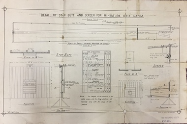
Plan, JC Brown, Detail of Step Butt and Screen for Miniature Rifle Range, 26 February 1910
On 19 July 1907, The Box Hill Reporter published an article on the Miniature Rifle Range. It stated: "Miniature Rifle Range for Kew. The Kew rifle club has made arrangements for the establishment of a miniature rifle range. The Kew borough council has provided a site in the yard at the rear of the town hall, fronting Brougham street. The site has been inspected by the military authorities, who have approved of the locality selected and the arrangements to be made to render the range absolutely safe. The plans are at present being prepared, and it is expected that the range will be completed within the next two months. The range will be under the direct control of the rifle club, subject to the supervision of a joint committee from the council and the club. The first committee will consist of Crs Wishart (mayor), Kellett, and Hiscock as representing the council, and Captain Argyle and Mr S. Abbott representing the rifle club. The range when completed will be available for the use of cadets, friendly societies, and other miniature rifle clubs in the district. Miniature rifle ranges are now occupying a great deal of attention in Great Britain, on the Continent, and in America. Lord Roberts, writing recently on the subject, remarks- "While I do not for a moment pretend that miniature rifle shooting is, in all respects, as useful as knowing how to shoot on a long range, I am satisfied that men can learn to shoot on miniature ranges, and that unless miniature ranges are very generally made use of, the greatest majority in this country will never learn to shoot at all." It is possible by this means also to divert the at present dangerous enthusiasm of uninstructed youths for the pea rifle into safer and more useful channels."Important early document identifying the specifications for a miniature rifle range in central Kew. Rifle clubs and rifle ranges were an important element in defending Victorians and Australians to outside threats. Single page plan (folded), created and approved in 1910, listing the approved specifications for a miniature rifle range in Brougham Street, Kew.Handwritten signature: J.M. / Staff officer for Works Victoria / 26-2-10rifle clubs - rifle ranges, miniature rifle ranges, rifle clubs -- kew (vic) -
Kew Historical Society Inc
Journal, Kewriosity : August 1991
The greening of Kew [Street Tree Masterplan] / p1. Free mulching of prunings / p1. Looming threat to the character of Kew [Victorian Government plans for medium-density housing] / p1. Diary dates for August / p2. Free self-defence and relaxation classes / p2. Anonymous house [house numbering requirements] / p2. Tom's incredible Spider Ring! ['The Spider Ring' by Track Players] / p2. Commentary / Cr Daryl Oldaker p3. Chief Executive's Column [Property valuations] / p3. Looking down rat holes [storm water drain audit] / p4. Waste plans not half baked [120 Litre Mobile Bin Recycling Trial] / p4. Lower your gas and electricity bills [Kew Community House workshops] / p4. Tribute to John Fleet Maughan 1898-1991 [City Engineer 1924-63] / p4. Indoor celebration of parkland [opening of Burke Road to High Street section of Outer Circle Linear Park] / p5. Forward planning for youth [survey] / p5. Kew saves an endangered species [Studley Park Red Gum - E.Studleyensis] / p5. Compliments, criticism and complaints [Kew Library Comments Book] / p6. Life in East Kew / Mr Tony de Clifford p6. New face [Pierrette Boustany, Outside School Hours Co-ordinator] / p6. New face [Lisa Gaffney, Public Relations Officer] / p6. Kewriosity deadlines / p6. Advertising [charges] / p6. Thankyou to the volunteers of Kew / p7. Another Anniversaire [Count Francoise de la Perouse] / p7. Heartfelt thanks [donation by East Kew Synagogue congregation to Kew Citizens' Advice Bureau] / p7. Kew Rotary Club good works / p7. Cinema to expand [Balwyn Cinema] / p7. Winter Song [Brian Hansford performs 'Winterreise at St John's Hall, Camberwell] / p8. Come to Cameron Country [Donald Cameron et al at Kew Gallery] / p8. You be the Gypsy [Victor Herbert's 'Gipsy Lady' by Viola Musical Comedy Society] / p8. Classical music in Kew [Kew Philharmonic Society] / p8.Kewriosity was a local newsletter combining Kew Council and community news. It was published between November 1983 and June 1994, replacing an earlier Kewriosity [broad] Sheet (1979-84). In producing Kewriosity, Council aimed to provide a range of interesting and informative articles covering its deliberations and decision making, together with items of general interest and importance to the Kew community and information not generally available through daily media outlets.non-fictionThe greening of Kew [Street Tree Masterplan] / p1. Free mulching of prunings / p1. Looming threat to the character of Kew [Victorian Government plans for medium-density housing] / p1. Diary dates for August / p2. Free self-defence and relaxation classes / p2. Anonymous house [house numbering requirements] / p2. Tom's incredible Spider Ring! ['The Spider Ring' by Track Players] / p2. Commentary / Cr Daryl Oldaker p3. Chief Executive's Column [Property valuations] / p3. Looking down rat holes [storm water drain audit] / p4. Waste plans not half baked [120 Litre Mobile Bin Recycling Trial] / p4. Lower your gas and electricity bills [Kew Community House workshops] / p4. Tribute to John Fleet Maughan 1898-1991 [City Engineer 1924-63] / p4. Indoor celebration of parkland [opening of Burke Road to High Street section of Outer Circle Linear Park] / p5. Forward planning for youth [survey] / p5. Kew saves an endangered species [Studley Park Red Gum - E.Studleyensis] / p5. Compliments, criticism and complaints [Kew Library Comments Book] / p6. Life in East Kew / Mr Tony de Clifford p6. New face [Pierrette Boustany, Outside School Hours Co-ordinator] / p6. New face [Lisa Gaffney, Public Relations Officer] / p6. Kewriosity deadlines / p6. Advertising [charges] / p6. Thankyou to the volunteers of Kew / p7. Another Anniversaire [Count Francoise de la Perouse] / p7. Heartfelt thanks [donation by East Kew Synagogue congregation to Kew Citizens' Advice Bureau] / p7. Kew Rotary Club good works / p7. Cinema to expand [Balwyn Cinema] / p7. Winter Song [Brian Hansford performs 'Winterreise at St John's Hall, Camberwell] / p8. Come to Cameron Country [Donald Cameron et al at Kew Gallery] / p8. You be the Gypsy [Victor Herbert's 'Gipsy Lady' by Viola Musical Comedy Society] / p8. Classical music in Kew [Kew Philharmonic Society] / p8. publications -- city of kew (vic.), kewriosity, council newsletters, community newsletters -
Kew Historical Society Inc
Journal, Kewriosity : October 1986
Focus on Children's Services [Children's Services Consultative Committee (CSCC)] / Elizabeth Sullivan p1&5. Kew is safe! [Local Government re-organisation] / p1. A gentle reminder about Kew's By-laws [overhanging trees] / p1. Dates for October / p2&8. [Community] Notices / p2&8. Commentary [How Council manages traffic] / Cr Joe Ormando, Mayor of Kew p3. Good gardening [Growing lawns] / Peter Davies p3. Profile - Cr Jim Tutt / p4. Radio controlled car track for Foley Park / p4. Focus on children [Focus on Children Report] / p5. Cap/disability / Craig Midgley p5. Doing something worthwhile [Interchange; Relief care for children with disabilities] / p6. Our bands are winners! [Kew Citizens' Band; Kew Junior Band] / p6. Would you like to be an honorary probation officer? / p6. Kew Community House [Annual dinner; A range of courses; Annual General Meeting; Your house] / Rhonda McCaw p7. Planning for retirement [Kew Early Planning for Retirement Group] / p7. Anyone for tennis? [Kew Uniting Church Tennis Club] / p8. Footy news [Kew Football Club] / p8. Keeping you informed [Citizens' Advice Bureau] / p8. Letter - Staff refute rumours about Library / Staff of Kew Library p8. Ever thought about playing Bowls [East Kew Bowling Club] / Gerard Petrie p8.Kewriosity was a local newsletter combining Kew Council and community news. It was published between November 1983 and June 1994, replacing an earlier Kewriosity [broad] Sheet (1979-84). In producing Kewriosity, Council aimed to provide a range of interesting and informative articles covering its deliberations and decision making, together with items of general interest and importance to the Kew community and information not generally available through daily media outlets.non-fictionFocus on Children's Services [Children's Services Consultative Committee (CSCC)] / Elizabeth Sullivan p1&5. Kew is safe! [Local Government re-organisation] / p1. A gentle reminder about Kew's By-laws [overhanging trees] / p1. Dates for October / p2&8. [Community] Notices / p2&8. Commentary [How Council manages traffic] / Cr Joe Ormando, Mayor of Kew p3. Good gardening [Growing lawns] / Peter Davies p3. Profile - Cr Jim Tutt / p4. Radio controlled car track for Foley Park / p4. Focus on children [Focus on Children Report] / p5. Cap/disability / Craig Midgley p5. Doing something worthwhile [Interchange; Relief care for children with disabilities] / p6. Our bands are winners! [Kew Citizens' Band; Kew Junior Band] / p6. Would you like to be an honorary probation officer? / p6. Kew Community House [Annual dinner; A range of courses; Annual General Meeting; Your house] / Rhonda McCaw p7. Planning for retirement [Kew Early Planning for Retirement Group] / p7. Anyone for tennis? [Kew Uniting Church Tennis Club] / p8. Footy news [Kew Football Club] / p8. Keeping you informed [Citizens' Advice Bureau] / p8. Letter - Staff refute rumours about Library / Staff of Kew Library p8. Ever thought about playing Bowls [East Kew Bowling Club] / Gerard Petrie p8. publications -- city of kew (vic.), kewriosity, council newsletters, community newsletters -
Kew Historical Society Inc
Journal, Kewriosity : April 1985
Occasional Care [Centre] is a winner [Strathalbyn Street] / p1. And what a Parade it was! [Kew Festival] / p1. Community Notices - General; Clubs and societies; Religious notices; Politics; Auxiliaries; Support Groups] / p2&8. Update: Notes from Council - Trees: Our heritage [street trees] / Cr Robin Saunders [Mayor of Kew] p3. Doorknock in traffic management Area 5 / p4. Driver needed! [Kew Community Bus] / p4. We have a place for your child! [Davis Street Kindergarten] / p4. Council supports Community Employment Program / p4. New Residents Kit / p4. What is a playgroup? [Highbury Grove Playgroup] / p5. Future planning for children's services / p5. Don't burn those leaves / p5. Kew Community House [short courses] / p5. Youth Page: What does the Youth Services Officer do? Junior footballers: where are you? [Kew Football Club]; Youth groups - let more people know about your club; Recreation and enjoyment / p6. Proposed Kew Full Day Care Centre / p7. Greek Easter / p7. "Spring" Festivals and the origins of the Easter Bunny / p7. This Kewriosity is being delivered to you by - Kew Preschool Support Group [Woodlands Avenue Baptist Church Hall] / p8. A fond farewell to A.C.K.D.A. [Artists’ Co-operative for the Kew/Deepdene area] / p8.Kewriosity was a local newsletter combining Kew Council and community news. It was published between November 1983 and June 1994, replacing an earlier Kewriosity [broad] Sheet (1979-84). In producing Kewriosity, Council aimed to provide a range of interesting and informative articles covering its deliberations and decision making, together with items of general interest and importance to the Kew community and information not generally available through daily media outlets.non-fictionOccasional Care [Centre] is a winner [Strathalbyn Street] / p1. And what a Parade it was! [Kew Festival] / p1. Community Notices - General; Clubs and societies; Religious notices; Politics; Auxiliaries; Support Groups] / p2&8. Update: Notes from Council - Trees: Our heritage [street trees] / Cr Robin Saunders [Mayor of Kew] p3. Doorknock in traffic management Area 5 / p4. Driver needed! [Kew Community Bus] / p4. We have a place for your child! [Davis Street Kindergarten] / p4. Council supports Community Employment Program / p4. New Residents Kit / p4. What is a playgroup? [Highbury Grove Playgroup] / p5. Future planning for children's services / p5. Don't burn those leaves / p5. Kew Community House [short courses] / p5. Youth Page: What does the Youth Services Officer do? Junior footballers: where are you? [Kew Football Club]; Youth groups - let more people know about your club; Recreation and enjoyment / p6. Proposed Kew Full Day Care Centre / p7. Greek Easter / p7. "Spring" Festivals and the origins of the Easter Bunny / p7. This Kewriosity is being delivered to you by - Kew Preschool Support Group [Woodlands Avenue Baptist Church Hall] / p8. A fond farewell to A.C.K.D.A. [Artists’ Co-operative for the Kew/Deepdene area] / p8. publications -- city of kew (vic.), kewriosity, council newsletters, community newsletters -
 Kew Historical Society Inc
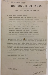
Document, Holland Loxton, Notification to the Residents of Derrick Street by the Local Board of Health, 1885, 1885
Streets and drains were the basic infrastructure problems for Kew in the 1880s. Decent streets and drains were fundamental to the quality of life of the residents. Without drainage, streets became muddy, boggy and sometimes impassable. Pools and puddles of stagnant water became smelly. The run off water, mixed with human and animal wastes, because there was no sewerage, became a health hazard. Streets and drains then became what were known as 'a nuisance'. Kew suffered from bouts of typhoid fever during the 1880s. Derrick Street was a private street on the margin of the business district of Kew and a well-used thoroughfare. We hear first about Derrick Street when the ratepayers applied to Council to have the street 'taken over' in January 1881. The Council agreed, after much debate, but ratepayers had to pay half the costs. The argument of the majority of the Council was that there was an established policy that ratepayers of private streets either had to hand over the street fully-formed or pay half the costs if Council did the work. It was felt that to make an exception for Derrick Street would create a precedent for ratepayers of other private streets. On the other hand the ratepayers, and a minority of Council, believed that there were extenuating circumstances in the case of Derrick Street. They believed that the costing by the Borough Surveyor was excessive. They felt the Council was partly responsible for the state of the street due to a channel on Bulleen Road, which deposited sand in the street. The Council had also put in some kerbing at the entrance to the street. Finally, the ratepayers believed that the street had become an important and convenient thoroughfare in Kew, and thus should be an exception to the policy on private streets. In the end a decision was delayed to allow the ratepayers to drain and form the street themselves. And there the matter stood till September 1882, when Miss Reilly complained about rubbish on a block of land in Derrick Street. So, in October 1882 the Council agreed to take over and form the street with the ratepayers paying half the costs. The ratepayers did not want to pay, so the argument continued in Council into 1883. There was a standoff for a further 18 months, until the problem could no longer be ignored. In October 1884 the Inspector of Nuisances and the Health Officer reported that Derrick Street was a health hazard as there was no drainage outlet for waste water. These reports changed the status of the problem of Derrick Street. It became an issue of public health, and thus the Council, acting as the Local Board of Health, had power to prepare plans and order the ratepayers to drain the street and pay all the costs, or let the Council do the work and charge ratepayers half the costs of the works. By April 1885, the time for ratepayers to complete the works themselves had expired, so the Council proceeded with the work and required ratepayers to pay for their share of the costs. All ratepayers had paid by the end of April except Mr Whiddycombe, who refused to pay. Mr Whiddycombe was warned to pay in October 1885. Legal action was taken against him in November. The Council lost the case on technical grounds. The Council, acting as the Local Board of Health, relaunched the legal action and won. The last we hear of Derrick Street is that seven day’s notice was given to Derrick Street ratepayers to pay for the drainage works in May 1887. We presume that Mr Whiddycombe paid. (Research: Andrew Frost)Rare and historic publication issued by the Board of Health in the Borough of Kew in 1885 to residents of Derrick street regarding the need for proper drainage for the purpose of improving public health.Printed formal notice sent by the Board of Health of the Borough of Kew to landowners in Derrick Street, Kew. The notice advised the owners that they were required to form and drain the street according to the levels and specifications approved by the Board. The letter was sent on January 23rd 1885, and signed by the Inspector of Nuisances.borough of kew -- greater melbourne (vic.), council notices -- public health, derrick street -- kew (vic.) -
 Kew Historical Society Inc
Plan, Melbourne & Metropolitan Board of Works : Borough of Kew : Detail Plan No.1291, 1905
The Melbourne and Metropolitan Board of Works (MMBW) plans were produced from the 1890s to the 1950s. They were crucial to the design and development of Melbourne's sewerage and drainage system. The plans, at a scale of 40 feet to 1 inch (1:480), provide a detailed historical record of Melbourne streetscapes and environmental features. Each plan covers one or two street blocks (roughly six streets), showing details of buildings, including garden layouts and ownership boundaries, and features such as laneways, drains, bridges, parks, municipal boundaries and other prominent landmarks as they existed at the time each plan was produced. (Source: State Library of Victoria). This plan forms part of a large group of MMBW plans and maps that was donated to the Society by the Mr Poulter, City Engineer of the City of Kew in 1989. Within this collection, thirty-five hand-coloured plans, backed with linen, are of statewide significance as they include annotations that provide details of construction materials used in buildings in the first decade of the 20th century as well as additional information about land ownership and usage. The copies in the Public Record Office Victoria and the State Library of Victoria are monochrome versions which do not denote building materials so that the maps in this collection are invaluable and unique tools for researchers and heritage consultants. A number of the plans are not held in the collection of the State Library of Victoria so they have the additional attribute of rarity.Original survey plan, issued by the MMBW to a contractor with responsibility for constructing sewers in the area identified on the plan within the Borough of Kew. The plan was at some stage hand-coloured, possibly by the contractor, but more likely by officers working in the Engineering Department of the Borough and later Town, then City of Kew. The hand-coloured sections of buildings on the plan were used to denote masonry or brick constructions (pink), weatherboard constructions (yellow), and public buildings (grey). A detail plan of part of Studley Park bordered by the major streets of Hodgson Street, Stevenson Street and Studley Park Road. Included on the plan are a number of significant Studley Park mansions in existence at the beginning of the 20th century. The unnamed street shown in the middle of the plan is McEvoy Street. The most important house still extant is Campion House, formerly named Dalsraith [Dalswraith] and Glendalough, owned since the 1940s by the Society of Jesus. Campion House can be seen on the corner of Hodgson and Studley Park Road. Its stables at the rear of the block have now been incorporated into a contemporary residence. An interesting feature of the plan is the 1910 annotation by Ed Seitz, professional designing engineer. Is Seitz the contractor who modified the MMBW original?melbourne and metropolitan board of works, detail plans, mmbw 1291, cartography -
 Kew Historical Society Inc
Plan, Melbourne and Metropolitan Board of Works, Melbourne & Metropolitan Board of Works : Borough of Kew : Detail Plan No.1294 & 1295, 1904
The Melbourne and Metropolitan Board of Works (MMBW) plans were produced from the 1890s to the 1950s. They were crucial to the design and development of Melbourne's sewerage and drainage system. The plans, at a scale of 40 feet to 1 inch (1:480), provide a detailed historical record of Melbourne streetscapes and environmental features. Each plan covers one or two street blocks (roughly six streets), showing details of buildings, including garden layouts and ownership boundaries, and features such as laneways, drains, bridges, parks, municipal boundaries and other prominent landmarks as they existed at the time each plan was produced. (Source: State Library of Victoria). This plan forms part of a large group of MMBW plans and maps that was donated to the Society by the Mr Poulter, City Engineer of the City of Kew in 1989. Within this collection, thirty-five hand-coloured plans, backed with linen, are of statewide significance as they include annotations that provide details of construction materials used in buildings in the first decade of the 20th century as well as additional information about land ownership and usage. The copies in the Public Record Office Victoria and the State Library of Victoria are monochrome versions which do not denote building materials so that the maps in this collection are invaluable and unique tools for researchers and heritage consultants. A number of the plans are not held in the collection of the State Library of Victoria so they have the additional attribute of rarity.Original survey plan, issued by the MMBW to a contractor with responsibility for constructing sewers in the area identified on the plan within the Borough of Kew. The plan was at some stage hand-coloured, possibly by the contractor, but more likely by officers working in the Engineering Department of the Borough and later Town, then City of Kew. The hand-coloured sections of buildings on the plan were used to denote masonry or brick constructions (pink), weatherboard constructions (yellow), and public buildings (grey).The streets and built structures in MMBW Detail Plan 1294 & 1295 were surveyed in 1903 and released to contractors in 1904. This plan is one of two in the collection where the lithographers amalgamated two separate plans. Both plans include sections of Studley Park. Dominating the south and west corners of Kew Junction are the Clifton and Kew Hotels. The Kew Hotel, owned by Patrick O’Shaughnessy was one of the oldest in Kew. MMBW plans were amended over time to take account of new subdivisions such as that which created Merrion Place. Of the four mansions shown in Studley Park Road, three remain – ‘Field Place’, the home of Frances Henty, ‘Leaghur’ and ‘Darley’. ‘Byram’ (later ‘Goathland’, then ‘Tara Hall’) was an architectural marvel. Designed in 1888 by E.G. Kilburn for the paper magnate George Ramsden, it was demolished in 1960. While an earlier sale of the southern section of Byram had created Tara Avenue in 1927, the demolition of the house in 1960 enabled the extension of Tara Avenue northward.melbourne and metropolitan board of works, detail plans, mmbw 1294, mmbw 1295, cartography -
 Kew Historical Society Inc
Plan, Melbourne & Metropolitan Board of Works : Borough of Kew : Detail Plan No.1296, 1904
The Melbourne and Metropolitan Board of Works (MMBW) plans were produced from the 1890s to the 1950s. They were crucial to the design and development of Melbourne's sewerage and drainage system. The plans, at a scale of 40 feet to 1 inch (1:480), provide a detailed historical record of Melbourne streetscapes and environmental features. Each plan covers one or two street blocks (roughly six streets), showing details of buildings, including garden layouts and ownership boundaries, and features such as laneways, drains, bridges, parks, municipal boundaries and other prominent landmarks as they existed at the time each plan was produced. (Source: State Library of Victoria)This plan forms part of a large group of MMBW plans and maps that was donated to the Society by the Mr Poulter, City Engineer of the City of Kew in 1989. Within this collection, thirty-five hand-coloured plans, backed with linen, are of statewide significance as they include annotations that provide details of construction materials used in buildings in the first decade of the 20th century as well as additional information about land ownership and usage. The copies in the Public Record Office Victoria and the State Library of Victoria are monochrome versions which do not denote building materials so that the maps in this collection are invaluable and unique tools for researchers and heritage consultants. A number of the plans are not held in the collection of the State Library of Victoria so they have the additional attribute of rarity.Original survey plan, issued by the MMBW to a contractor with responsibility for constructing sewers in the area identified on the plan within the Borough of Kew. The plan was at some stage hand-coloured, possibly by the contractor, but more likely by officers working in the Engineering Department of the Borough and later Town, then City of Kew. The hand-coloured sections of buildings on the plan were used to denote masonry or brick constructions (pink), weatherboard constructions (yellow), and public buildings (grey). This area was once known as O’Shaughnessy’s Paddock. O’Shaughnessy was the licensee of the Kew Hotel. The ‘Paddock’ or farm was for many years the closest farm to Melbourne. By 1903, when this plan was surveyed and lithographed, little of the farm remained. The area is dominated by a ‘clay hole’, on the site of the current Foley Reserve. It was used by Smart’s Brickyard from the 1880s until 1911, when the Council purchased it for a rubbish dump. It is notable as the site is one of the few industrial operations to have existed in Kew. By 1903, urban development was characterised by larger houses fronting Barkers Road and brick and weatherboard villas in Foley Street. Nearer the pit, weatherboard houses predominated. Foley Street bisected the triangular block and continued right to Denmark Street. At this stage, a house impeded the through road, only allowing access via a right of way to High Street.melbourne and metropolitan board of works, detail plans, mmbw 1296, cartography -
 Kew Historical Society Inc
Plan, Melbourne & Metropolitan Board of Works : Borough of Kew : Detail Plan No.1297, 1904
The Melbourne and Metropolitan Board of Works (MMBW) plans were produced from the 1890s to the 1950s. They were crucial to the design and development of Melbourne's sewerage and drainage system. The plans, at a scale of 40 feet to 1 inch (1:480), provide a detailed historical record of Melbourne streetscapes and environmental features. Each plan covers one or two street blocks (roughly six streets), showing details of buildings, including garden layouts and ownership boundaries, and features such as laneways, drains, bridges, parks, municipal boundaries and other prominent landmarks as they existed at the time each plan was produced. (Source: State Library of Victoria)This plan forms part of a large group of MMBW plans and maps that was donated to the Society by the Mr Poulter, City Engineer of the City of Kew in 1989. Within this collection, thirty-five hand-coloured plans, backed with linen, are of statewide significance as they include annotations that provide details of construction materials used in buildings in the first decade of the 20th century as well as additional information about land ownership and usage. The copies in the Public Record Office Victoria and the State Library of Victoria are monochrome versions which do not denote building materials so that the maps in this collection are invaluable and unique tools for researchers and heritage consultants. A number of the plans are not held in the collection of the State Library of Victoria so they have the additional attribute of rarity.Original survey plan, issued by the MMBW to a sewage contractor with responsibility for constructing sewers in the area identified on the plan within the Borough of Kew. The plan was at some stage hand-coloured, possibly by the contractor, but more likely by officers working in the Engineering Department of the Borough and later Town, then City of Kew. The hand-coloured sections of buildings on the plan were used to denote masonry or brick constructions (pink), weatherboard constructions (yellow), and public buildings (grey). This plan of Kew encompasses the area bounded by Barkers Road, High Street and Stevenson Street. Because of the angle created by High Street, a number of houses on the northern side of High Street are shown. The area is dominated by one of the great original landholdings in Kew, described here as the ‘Findon Paddock’. ‘Findon’, the house from which the name of the paddock was taken fronts Stevenson Street and was clearly a rambling structure. The best-known occupant of Findon was Henry ‘Money Miller’ who bought the house in 1871. Miller was a member of Victoria’s first parliament and assisted in the framing of its constitution. Findon was to be subdivided as early as 1912, when the Findon Subdivision was advertised to be sold by auction. In the plan of the subdivision, the original house is not shown, so, presumably it had previously been demolished. Fincham & Son moved the organ, built by Henry Willis, which was installed in the house, first to ‘Whernside’ in Toorak, and later to the Box Hill Methodist Church.melbourne and metropolitan board of works, detail plans, mmbw 1297, cartography, kew (vic.) — municipal collection