Showing 549 items
matching significant tree
-
 Ballarat Heritage Services
Photograph - Digital photographs, L.J. Gervasoni, Wombat Hill Botanic Gardens 150 anniversary event Daylesford community event, 2013
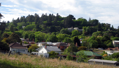
... . The Daylesford Botanic Gardens are historically significant as a fine.... The Daylesford Botanic Gardens are historically significant as a fine ...The Daylesford Botanic Gardens are of historic, scientific (botanic), and aesthetic significance to the State of Victoria. The Daylesford Botanic Gardens are historically significant as a fine example of a regional botanic garden demonstrating the typical characteristics of a carriage drive, informal park layout, decorative structures and works such as the memorial tower, conservatory, rotunda, cascade and fernery, which contrasts with the open lawns planted with specimen trees, areas of intensive horticultural interest and close proximity to a township developed during the mid to late nineteenth century. The Daylesford Botanic Gardens are historically significant for the design input by noted landscape designer William Sangster, and for the survival of his 1884 plan, which is a rare example of a plan from this prolific garden designer. The Daylesford Botanic Gardens are of scientific (botanic) significance for the extensive conifer collection and cool climate plants. The Gardens contain an outstanding collection of conifers and other mature trees, many of which were donated by renowned botanist Ferdinand von Mueller. Significant trees include Pinus ponderosa (Western Yellow Pine), Pinus coulteri (Big Cone Pine), twoAbies nordmanniana (Caucasian Fir), Abies pinsapo, (Spanish Fir) and a Cedrus atlantica f. glauca(Blue Atlas Cedar), Pinus wallichiana (Bhutan Pine), Pinus pinaster (Maritime Pine), Sequoiadendron giganteum (Giant Redwood), (Monkey Puzzle) and Aesculus hippocastanum (Horse Chestnut), many the largest or finest examples in Victoria. Other outstanding trees include a Tilia cordata (Small-leaved European Linden), a row of Cupressus lusitanica (Mexican cypress), a Quercus robur (English Oak) planted in 1863, avenues of Dutch Elms and a rare Quercus leucotrichophora (Himalayan Oak). The Daylesford Botanic Gardens are of aesthetic significance as a rare example of a botanic garden spectacularly sited on an extinct volcanic cone which allows a panoramic view, aided by the 1938 Pioneers’ Memorial Tower, as well as vistas within and out of the gardens and from the township to the gardens. As the most prominent local landmark, the Garden’s vertical dominance in the landscape provides a dark contrast to the elms avenues, oaks and other deciduous species. (Heritage Victoria Register, )Digital imagesvictoria, 150, anniversary, botanic, gardens, wombat hill, botanic gardens, heritage, celebration, garden party, daylesford, people, crowd, community, john hawker, john madigan, stilt, trees, owls, wombat hill botanic gardens -
 Ballarat Heritage Services
Photograph - digital photographs, Lisa Gervasoni, Wombat Hill, Daylesford, c2006-2016
... . The Daylesford Botanic Gardens are historically significant as a fine.... The Daylesford Botanic Gardens are historically significant as a fine ...The Daylesford Botanic Gardens are of historic, scientific (botanic), and aesthetic significance to the State of Victoria. The Daylesford Botanic Gardens are historically significant as a fine example of a regional botanic garden demonstrating the typical characteristics of a carriage drive, informal park layout, decorative structures and works such as the memorial tower, conservatory, rotunda, cascade and fernery, which contrasts with the open lawns planted with specimen trees, areas of intensive horticultural interest and close proximity to a township developed during the mid to late nineteenth century. The Daylesford Botanic Gardens are historically significant for the design input by noted landscape designer William Sangster, and for the survival of his 1884 plan, which is a rare example of a plan from this prolific garden designer. The Daylesford Botanic Gardens are of scientific (botanic) significance for the extensive conifer collection and cool climate plants. The Gardens contain an outstanding collection of conifers and other mature trees, many of which were donated by renowned botanist Ferdinand von Mueller. Significant trees include Pinus ponderosa (Western Yellow Pine), Pinus coulteri (Big Cone Pine), twoAbies nordmanniana (Caucasian Fir), Abies pinsapo, (Spanish Fir) and a Cedrus atlantica f. glauca(Blue Atlas Cedar), Pinus wallichiana (Bhutan Pine), Pinus pinaster (Maritime Pine), Sequoiadendron giganteum (Giant Redwood), (Monkey Puzzle) and Aesculus hippocastanum (Horse Chestnut), many the largest or finest examples in Victoria. Other outstanding trees include a Tilia cordata (Small-leaved European Linden), a row of Cupressus lusitanica (Mexican cypress), a Quercus robur (English Oak) planted in 1863, avenues of Dutch Elms and a rare Quercus leucotrichophora (Himalayan Oak). The Daylesford Botanic Gardens are of aesthetic significance as a rare example of a botanic garden spectacularly sited on an extinct volcanic cone which allows a panoramic view, aided by the 1938 Pioneers’ Memorial Tower, as well as vistas within and out of the gardens and from the township to the gardens. As the most prominent local landmark, the Garden’s vertical dominance in the landscape provides a dark contrast to the elms avenues, oaks and other deciduous species. (Heritage Victoria Register, )Colour photograph of Wombat Hill Botanical Gardens, Daylesford.heritage, daylesford, townscape, wombat hill, wombat hill botanical gardens, wombat hill botanic gardens -
 Ballarat Heritage Services
Photograph - Digital photographs, L.J. Gervasoni, Wombat Hill in the Fog, c2015
... . The Daylesford Botanic Gardens are historically significant as a fine.... The Daylesford Botanic Gardens are historically significant as a fine ...The Daylesford Botanic Gardens are of historic, scientific (botanic), and aesthetic significance to the State of Victoria. The Daylesford Botanic Gardens are historically significant as a fine example of a regional botanic garden demonstrating the typical characteristics of a carriage drive, informal park layout, decorative structures and works such as the memorial tower, conservatory, rotunda, cascade and fernery, which contrasts with the open lawns planted with specimen trees, areas of intensive horticultural interest and close proximity to a township developed during the mid to late nineteenth century. The Daylesford Botanic Gardens are historically significant for the design input by noted landscape designer William Sangster, and for the survival of his 1884 plan, which is a rare example of a plan from this prolific garden designer. The Daylesford Botanic Gardens are of scientific (botanic) significance for the extensive conifer collection and cool climate plants. The Gardens contain an outstanding collection of conifers and other mature trees, many of which were donated by renowned botanist Ferdinand von Mueller. Significant trees include Pinus ponderosa (Western Yellow Pine), Pinus coulteri (Big Cone Pine), twoAbies nordmanniana (Caucasian Fir), Abies pinsapo, (Spanish Fir) and a Cedrus atlantica f. glauca(Blue Atlas Cedar), Pinus wallichiana (Bhutan Pine), Pinus pinaster (Maritime Pine), Sequoiadendron giganteum (Giant Redwood), (Monkey Puzzle) and Aesculus hippocastanum (Horse Chestnut), many the largest or finest examples in Victoria. Other outstanding trees include a Tilia cordata (Small-leaved European Linden), a row of Cupressus lusitanica (Mexican cypress), a Quercus robur (English Oak) planted in 1863, avenues of Dutch Elms and a rare Quercus leucotrichophora (Himalayan Oak). The Daylesford Botanic Gardens are of aesthetic significance as a rare example of a botanic garden spectacularly sited on an extinct volcanic cone which allows a panoramic view, aided by the 1938 Pioneers’ Memorial Tower, as well as vistas within and out of the gardens and from the township to the gardens. As the most prominent local landmark, the Garden’s vertical dominance in the landscape provides a dark contrast to the elms avenues, oaks and other deciduous species. (Heritage Victoria Register, )Black and white photograph of a treed landscape covered with fog. The trees are in the Daylesford Botanical Gardens on Wombat Hill.wombat hill botanic gardens, wombat hill, daylesford, daylesford botanic gardens, fog, weather, arboretum -
 Ballarat Heritage Services
Photograph - Photograph - Colour, Clare Gervasoni, Wombat Botanic Gardens, Daylesford, 2019, 23/04/2019
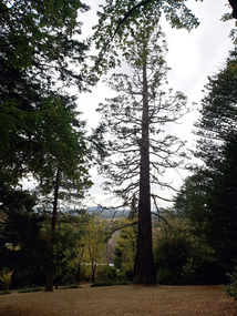
... . The Daylesford Botanic Gardens are historically significant as a fine.... The Daylesford Botanic Gardens are historically significant as a fine ...The Daylesford Botanic Gardens are of historic, scientific (botanic), and aesthetic significance to the State of Victoria. The Daylesford Botanic Gardens are historically significant as a fine example of a regional botanic garden demonstrating the typical characteristics of a carriage drive, informal park layout, decorative structures and works such as the memorial tower, conservatory, rotunda, cascade and fernery, which contrasts with the open lawns planted with specimen trees, areas of intensive horticultural interest and close proximity to a township developed during the mid to late nineteenth century. The Daylesford Botanic Gardens are historically significant for the design input by noted landscape designer William Sangster, and for the survival of his 1884 plan, which is a rare example of a plan from this prolific garden designer. The Daylesford Botanic Gardens are of scientific (botanic) significance for the extensive conifer collection and cool climate plants. The Gardens contain an outstanding collection of conifers and other mature trees, many of which were donated by renowned botanist Ferdinand von Mueller. Significant trees include Pinus ponderosa (Western Yellow Pine), Pinus coulteri (Big Cone Pine), twoAbies nordmanniana (Caucasian Fir), Abies pinsapo, (Spanish Fir) and a Cedrus atlantica f. glauca(Blue Atlas Cedar), Pinus wallichiana (Bhutan Pine), Pinus pinaster (Maritime Pine), Sequoiadendron giganteum (Giant Redwood), (Monkey Puzzle) and Aesculus hippocastanum (Horse Chestnut), many the largest or finest examples in Victoria. Other outstanding trees include a Tilia cordata (Small-leaved European Linden), a row of Cupressus lusitanica (Mexican cypress), a Quercus robur (English Oak) planted in 1863, avenues of Dutch Elms and a rare Quercus leucotrichophora (Himalayan Oak). The Daylesford Botanic Gardens are of aesthetic significance as a rare example of a botanic garden spectacularly sited on an extinct volcanic cone which allows a panoramic view, aided by the 1938 Pioneers’ Memorial Tower, as well as vistas within and out of the gardens and from the township to the gardens. As the most prominent local landmark, the Garden’s vertical dominance in the landscape provides a dark contrast to the elms avenues, oaks and other deciduous species. (Heritage Victoria Register, )A tree in the Wombat Hill Gardens.wombat botanical gardens, daylesford botanical gardens, daylesford, trees, wombat hill botanic gardens -
 Ballarat Heritage Services
Photograph - Photograph - Colour, Clare Gervasoni, Wombat Botanic Gardens, Daylesford, 2019, 23/04/2019
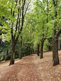
... . The Daylesford Botanic Gardens are historically significant as a fine.... The Daylesford Botanic Gardens are historically significant as a fine ...The Daylesford Botanic Gardens are of historic, scientific (botanic), and aesthetic significance to the State of Victoria. The Daylesford Botanic Gardens are historically significant as a fine example of a regional botanic garden demonstrating the typical characteristics of a carriage drive, informal park layout, decorative structures and works such as the memorial tower, conservatory, rotunda, cascade and fernery, which contrasts with the open lawns planted with specimen trees, areas of intensive horticultural interest and close proximity to a township developed during the mid to late nineteenth century. The Daylesford Botanic Gardens are historically significant for the design input by noted landscape designer William Sangster, and for the survival of his 1884 plan, which is a rare example of a plan from this prolific garden designer. The Daylesford Botanic Gardens are of scientific (botanic) significance for the extensive conifer collection and cool climate plants. The Gardens contain an outstanding collection of conifers and other mature trees, many of which were donated by renowned botanist Ferdinand von Mueller. Significant trees include Pinus ponderosa (Western Yellow Pine), Pinus coulteri (Big Cone Pine), twoAbies nordmanniana (Caucasian Fir), Abies pinsapo, (Spanish Fir) and a Cedrus atlantica f. glauca(Blue Atlas Cedar), Pinus wallichiana (Bhutan Pine), Pinus pinaster (Maritime Pine), Sequoiadendron giganteum (Giant Redwood), (Monkey Puzzle) and Aesculus hippocastanum (Horse Chestnut), many the largest or finest examples in Victoria. Other outstanding trees include a Tilia cordata (Small-leaved European Linden), a row of Cupressus lusitanica (Mexican cypress), a Quercus robur (English Oak) planted in 1863, avenues of Dutch Elms and a rare Quercus leucotrichophora (Himalayan Oak). The Daylesford Botanic Gardens are of aesthetic significance as a rare example of a botanic garden spectacularly sited on an extinct volcanic cone which allows a panoramic view, aided by the 1938 Pioneers’ Memorial Tower, as well as vistas within and out of the gardens and from the township to the gardens. As the most prominent local landmark, the Garden’s vertical dominance in the landscape provides a dark contrast to the elms avenues, oaks and other deciduous species. (Heritage Victoria Register, 2025)An avenue of trees in the Wombat Hill Gardens. wombat botanical gardens, daylesford botanical gardens, daylesford, trees -
 Ballarat Heritage Services
Photograph - Photograph - Colour, Clare Gervasoni, Wombat Botanic Gardens, Daylesford, 2019, 23/04/2019
... . The Daylesford Botanic Gardens are historically significant as a fine.... The Daylesford Botanic Gardens are historically significant as a fine ...The Daylesford Botanic Gardens are of historic, scientific (botanic), and aesthetic significance to the State of Victoria. The Daylesford Botanic Gardens are historically significant as a fine example of a regional botanic garden demonstrating the typical characteristics of a carriage drive, informal park layout, decorative structures and works such as the memorial tower, conservatory, rotunda, cascade and fernery, which contrasts with the open lawns planted with specimen trees, areas of intensive horticultural interest and close proximity to a township developed during the mid to late nineteenth century. The Daylesford Botanic Gardens are historically significant for the design input by noted landscape designer William Sangster, and for the survival of his 1884 plan, which is a rare example of a plan from this prolific garden designer. The Daylesford Botanic Gardens are of scientific (botanic) significance for the extensive conifer collection and cool climate plants. The Gardens contain an outstanding collection of conifers and other mature trees, many of which were donated by renowned botanist Ferdinand von Mueller. Significant trees include Pinus ponderosa (Western Yellow Pine), Pinus coulteri (Big Cone Pine), twoAbies nordmanniana (Caucasian Fir), Abies pinsapo, (Spanish Fir) and a Cedrus atlantica f. glauca(Blue Atlas Cedar), Pinus wallichiana (Bhutan Pine), Pinus pinaster (Maritime Pine), Sequoiadendron giganteum (Giant Redwood), (Monkey Puzzle) and Aesculus hippocastanum (Horse Chestnut), many the largest or finest examples in Victoria. Other outstanding trees include a Tilia cordata (Small-leaved European Linden), a row of Cupressus lusitanica (Mexican cypress), a Quercus robur (English Oak) planted in 1863, avenues of Dutch Elms and a rare Quercus leucotrichophora (Himalayan Oak). The Daylesford Botanic Gardens are of aesthetic significance as a rare example of a botanic garden spectacularly sited on an extinct volcanic cone which allows a panoramic view, aided by the 1938 Pioneers’ Memorial Tower, as well as vistas within and out of the gardens and from the township to the gardens. As the most prominent local landmark, the Garden’s vertical dominance in the landscape provides a dark contrast to the elms avenues, oaks and other deciduous species. (Heritage Victoria Register, 2025)A large tree in the Wombat Gardens. wombat botanical gardens, daylesford botanical gardens, daylesford, trees, lisa gervasoni, wombat botanic gardens -
 Eltham District Historical Society Inc
Photograph - Digital Photograph, Alan King, Heritage apple tree, 24 January 2008
... of Significant Trees, as the oldest apple tree in Victoria. Published... of Significant Trees, as the oldest apple tree in Victoria. Published ...This old apple tree situated beside the Plenty River Trail at Greensborough has been associated with Melbourne Founder John Batman. Known as Batman's Tree, this apple tree is on the bank of the Plenty River near Leischa Court, Greensborough. It is said that Melbourne Founder John Batman may have planted the tree and later signed his treaty here with the Aboriginal people. It still bears fruit and its recorded on the National Trust's Register of Significant Trees, as the oldest apple tree in Victoria. Published: Nillumbik Now and Then / Marguerite Marshall 2008; photographs Alan King with Marguerite Marshall.; p7 Was This John Batman's Tree? An apple tree on the bank of the Plenty River near Leischa Court, Greensborough, is believed to have belonged to Melbourne’s founder, John Batman. It could also stand where John Batman signed his famous treaty with the Aboriginal people.1 Known as Batman’s Tree, it still bears fruit and is recorded on the National Trust’s Register of Significant Trees, as the oldest apple tree in Victoria. It is ‘Believed to have been planted by either John Batman, (c1837) or Martin Batey (1841)’.2 In 1966 a Horticultural Adviser, Mr Rolfe, after extensive questioning of aged Greensborough residents, wrote: ‘it thus seems fairly certain that the old tree on the banks of the Plenty River is an original Batman apple tree’. Mr Rolfe said that the tree stood on a spot formerly called Wattle Bend: ‘one of the sites claimed to be where John Batman signed his famous treaty with the aboriginals. ‘My main source of information has been interviews with people who attended school in the Greensborough area from 70 to 80 years ago. Their parents were close to the days when Melbourne was founded so information passed on by word of mouth.’ Around 1920 the tree was struck by lightning and a concrete block was placed in the split. The concrete is inscribed with the date 1841 when the tree was thought to have been planted. Not everyone agrees with Mr Rolfe however. Former secretary of the Nillumbik Historical Society, Kevin Patterson, said there was no written evidence to support the claim. But he said the tree had been known to locals for decades as Batman’s Tree. In the 1920s a holiday resort in the area advertised: ‘Come to Greensborough and see John Batman’s tree’. Mr Patterson said it was thought that when Batman died in 1839 his land was sold and a Greensborough man Frederick Flintoff bought seedlings from his orchard for £1 each. This was the only one left.3 Mr Rolfe said: ‘If planted in 1837, or even a few years later, it undoubtedly is the oldest living apple tree in Victoria. Title records of the property on which the tree grows show that the land was a crown grant of F D Wickham in 1840. Mr Wickham was reputed to be a friend of John Batman. All the early settlers prior to the crown grants were squatters, by virtue of Batman’s treaty. This treaty was revoked by the then New South Wales Government, so it is likely that Wickham or an agent was in occupation before 1840. ‘According to Mrs Mavis Latham (John Batman – Great Australian Series, Oxford University Press) when Batman came to Port Phillip in 1835 he brought fruit trees with him. He failed to get a crown grant for his selection on Collins Street, which included 20 acres (eight ha) of orchard and cultivation. His residence became the Government Office and Melbourne grew from wild bushland in 1835 to a town of over 20,000 people by 1841. It is possible Batman visited Wickham and presented him with a tree.’ However a Flintoff descendant in 1933 said Frederick Flintoff ordered his bailiff Martin Batey to transplant the Batman Tree from the Spencer Street orchard to its present site as a memorial to his friend Batman.4 Mr Rolfe spoke to many people, including descendants of the Bateys and Flintoffs and pupils at the Greensborough Primary School. Many had gained their information from a ‘very highly respected’ head master Lewis Amiet at the Greensborough School from 1895 to 1917. He must have gained this information from residents in the district and had this information been incorrect, the parents of the children would have promptly corrected him.’ One woman who attended the school before Mr Amiet’s appointment, said the previous teacher also taught that the tree on the Plenty River was a Batman tree, Mr Rolfe said.This collection of almost 130 photos about places and people within the Shire of Nillumbik, an urban and rural municipality in Melbourne's north, contributes to an understanding of the history of the Shire. Published in 2008 immediately prior to the Black Saturday bushfires of February 7, 2009, it documents sites that were impacted, and in some cases destroyed by the fires. It includes photographs taken especially for the publication, creating a unique time capsule representing the Shire in the early 21st century. It remains the most recent comprehenesive publication devoted to the Shire's history connecting local residents to the past. nillumbik now and then (marshall-king) collection, greensborough, john batman tree, plenty river trail -
 Ballarat Heritage Services
Photograph - Digital photographs, L.J. Gervasoni, Wombat Hill Botanic Gardens 150 anniversary event Daylesford organiser Gael Shannon, 2013
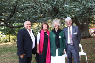
... . Significant trees include Pinus ponderosa (Western Yellow Pine), Pinus.... Significant trees include Pinus ponderosa (Western Yellow Pine), Pinus ...The Wombat Hill Botanic Gardens 150 anniversary event organiser was Gael Shannon. The Daylesford Botanic Gardens are of historic, scientific (botanic), and aesthetic significance to the State of Victoria. The Daylesford Botanic Gardens are historically significant as a fine example of a regional botanic garden demonstrating the typical characteristics of a carriage drive, informal park layout, decorative structures and works such as the memorial tower, conservatory, rotunda, cascade and fernery, which contrasts with the open lawns planted with specimen trees, areas of intensive horticultural interest and close proximity to a township developed during the mid to late nineteenth century. The Daylesford Botanic Gardens are historically significant for the design input by noted landscape designer William Sangster, and for the survival of his 1884 plan, which is a rare example of a plan from this prolific garden designer. The Daylesford Botanic Gardens are of scientific (botanic) significance for the extensive conifer collection and cool climate plants. The Gardens contain an outstanding collection of conifers and other mature trees, many of which were donated by renowned botanist Ferdinand von Mueller. Significant trees include Pinus ponderosa (Western Yellow Pine), Pinus coulteri (Big Cone Pine), twoAbies nordmanniana (Caucasian Fir), Abies pinsapo, (Spanish Fir) and a Cedrus atlantica f. glauca(Blue Atlas Cedar), Pinus wallichiana (Bhutan Pine), Pinus pinaster (Maritime Pine), Sequoiadendron giganteum (Giant Redwood), (Monkey Puzzle) and Aesculus hippocastanum (Horse Chestnut), many the largest or finest examples in Victoria. Other outstanding trees include a Tilia cordata (Small-leaved European Linden), a row of Cupressus lusitanica (Mexican cypress), a Quercus robur (English Oak) planted in 1863, avenues of Dutch Elms and a rare Quercus leucotrichophora (Himalayan Oak). The Daylesford Botanic Gardens are of aesthetic significance as a rare example of a botanic garden spectacularly sited on an extinct volcanic cone which allows a panoramic view, aided by the 1938 Pioneers’ Memorial Tower, as well as vistas within and out of the gardens and from the township to the gardens. As the most prominent local landmark, the Garden’s vertical dominance in the landscape provides a dark contrast to the elms avenues, oaks and other deciduous species. (Heritage Victoria Register, )Four people photographed at the 150th anniversary event at the Wombat Botanic Gardens.victoria, 150, anniversary, botanic, gardens, wombat hill, botanic gardens, heritage, celebration, garden party, daylesford, people, crowd, community, organiser, tour, gael shannon, don henderson, wombat hill botanic gardens -
 The Beechworth Burke Museum
Animal specimen - King Parrot, Trustees of the Australian Museum, 1860-1880
This specimen is part of a collection of almost 200 animal specimens that were originally acquired as skins from various institutions across Australia, including the Australian Museum in Sydney and the National Museum of Victoria (known as Museums Victoria since 1983), as well as individuals such as amateur anthropologist Reynell Eveleigh Johns between 1860-1880. These skins were then mounted by members of the Burke Museum Committee and put-on display in the formal space of the Museum’s original exhibition hall where they continue to be on display. This display of taxidermy mounts initially served to instruct visitors to the Burke Museum of the natural world around them, today it serves as an insight into the collecting habits of the 19th century. The red-and green Australian King-Parrot is seldom seen flying above the tree tops of the dense forests which it inhabits — it prefers to fly below tree level, weaving in and out through the tree trunks instead. When they are disturbed by a person, they usually fly off with a harsh screech, and often do not land until they are lost to view. Their flight is swift and strong, characterised by deep, rhythmic wing-beats and regularly punctuated with rapid twists and turns.This specimen is part of a significant and rare taxidermy mount collection in the Burke Museum. This collection is scientifically and culturally important for reminding us of how science continues to shape our understanding of the modern world. They demonstrate a capacity to hold evidence of how Australia’s fauna history existed in the past and are potentially important for future environmental research. This collection continues to be on display in the Museum and has become a key part to interpreting the collecting habits of the 19th century. Male Australian King-Parrots are the only Australian parrots with a completely red head. Females are similar to males except that they have a completely green head and breast. Both sexes have a red belly and a green back, with green wings and a long green tail. King parrots are normally encountered in pairs or family groups. This particular specimen has duller colour and appears more orange with a misshapen head Label: National Museum Victoria / King Parrot / Aprosmietus W5435 / Gris (recht) Mount: APPOSMICTUS / SCAPULARIS / King Parrottaxidermy, parrot, bird, king parrot -
 The Beechworth Burke Museum
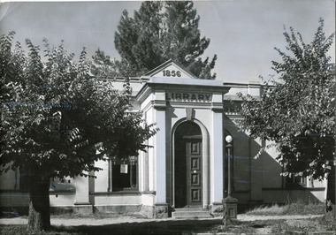
Photograph, Caldwell, c1950/60s
A photo of the original Burke Library building between two medium sized trees, a lamp post sits between them and a large tree is behind the building. This photo was taken c1950/60s.This photo is of both historical and social significance to the people and community of Beechworth because it shows the development of the Burke Museum from what it was in this picture, to what can be seen today. It also shows the Burke Museum's prominent architecture marking it as a particular point of interest within Beechworth. Along with the aspects of the building that the Burke museum is known for today, such as the façade and the central lamp post, all of which are significant to the town of Beechworth and its people.Black and white rectangular photograph printed on photographic paper.Obverse: 1856 / Library Reverse: Beechworth Library / 33 1/3% / Caldwell / 19 eu (illegible) / 11 eu (illegible) / 729 / 3 1/6 / BMM 8691 / S / T / E / T (Scribbles and arrows across the page)burke museum, beechworth, 1950s, architecture, landscaping, development -
 The Beechworth Burke Museum
Photograph, 2000
Woolshed is a small area about five kilometres north west of Beechworth, and almost about 225km north east of Melbourne. When gold was discovered at the nearby Spring Creek in February 1852, Woolshed was one of three settlements set up to house miners and their families. At its peak in 1857, Woolshed was also populated by 29 storekeepers and 14 hotels, as well as the Woolshed State School, which stood near where this photograph was taken. The school often played host to public meetings, as well as a public dance in 1897. The school was subject to some controversy in 1874 when one parent complained about the head of the school in the local newspaper, the Owens and Murray Advertiser, and at least three letters to the editor were exchanged between the two. According to the parent, C. O'Donoghue was not providing enough amusement for the children and was disrespectful to parents and staff. When the State Governor, Sir Reginald Talbot, visited Beechworth in 1906, the school organised a celebratory welcome. The Woolshed State School was ultimately closed in 1922 as miners had exhausted the Spring Creek gold supply and were moving elsewhere. This photograph, taken in about 2000, shows the trees that grew on or near the site of the original school. The Woolshed State School Honour Roll, with a list of the men from the school who served in the First World War, also still exists. It is stored in the Beechworth RSL as of 2015.This photograph is significant for its connection to an important site in Beechworth's gold mining history. Woolshed served a significant community of miners, with a population of at least 138 according to the 1911 census, with families that needed the school site to ensure their children's education. The image is also useful for prompting discussion about how Beechworth has changed over time, with the photograph taken 78 years after the school closed down.A colour rectangular photograph printed on glossy photographic paper.Woolshed State. / School site / 2000 / - remnant trees / / cobeechworth, burke museum, school, education, trees, nature, state school, woolshed, gold mining, teachers, over time, owens and murray advertiser, public meetings, public dance, c. o'donoghue, spring creek, state governor, sir reginald talbot, miners, honour roll, world war 1 -
 The Beechworth Burke Museum
Postcard, 1910 - 1912
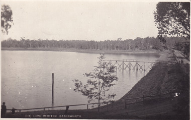
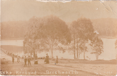
This photograph is taken of Lake Kerferd in around 1910. The photograph shows the road circling around the large lake and the jetty on the lake. On the other side, there is a written message from Fred Pulling to Win Pulling. Fred seems to have gone away and was not sure when he would return. He was also glad to hear about a gentlemen called Perc, who he stated to be a 'decent enough chap'.This postcard is significant because Lake Kerferd itself is significant within Beechworth's history. This lake was constructed in 1862 and was named after the former Beechworth Mayor, Hon. G B Kerferd. This lake was originally constructed to supply the town with water. Fred's correspondence with Win demonstrates a glimpse into what life was like during this time. Black and white rectangular postcard printed on cardObverse: (113) Lake Kerferd Beechworth / Reverse: Beechworth / 29.11.19 / [ Stamped: POST CARD / KODAK AUSTRALIA / Dear Win / Gald to hear that you / have made up your mind about / Perc / He seems a decent enough chap / too / Anyway, Thanks for the letter / Dont exactly know when we are / returning / will write later. Regards / to Nell of course, and H. (indecipherable) / Lots of love / Fred / lake kerferd, jetty, chap, postcard, letter, trees, lake, horse drawn carriage, horse drawn cart, kodak, australia, gum trees, gravel road, beechworth, kerferd -
 The Beechworth Burke Museum
Photograph, c1900
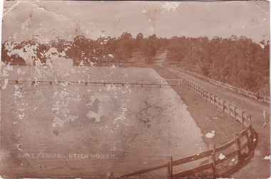
... disappears into the trees. This photograph is significant because ...This photograph is of Lake Kerferd in the early 1900s. Both the spillway for the lake and the jetty can be seen. There is also a road that wraps around the lake and eventually disappears into the trees. This photograph is significant because it shows Lake Kerferd at the beginning of the twentieth century. The lake itself is significant because it was Beechworth's main source of water. This made it very important to the community.Black and white rectangular photograph printed on paperLake Kerferd, Beechworth / spillway, lake, dam, lake kerferd, kerferd, road, photograph, trees, gum tree, jetty, wooden fence, gravel road, australia, victoria, beechworth, 1900s beechworth, waterworks, water, water supply -
 The Beechworth Burke Museum
Photograph - Postcard, c1900
This is a photograph of Lake Kerferd in Beechworth taken in the late nineteenth or early twentieth centuries. It depicts two women, two young boys and four young girls standing in front of the lake. The women seem to be either the mothers or caregivers of the children. This photograph is significant because it depicts a group of people enjoying a outing at Lake Kerferd. This demonstrates that Lake Kerferd was a place of enjoyment for the people that lived in Beechworth during this time period. Lake Kerferd itself was also Beechworth's main water supply. This makes it very important to the community who lived there. Sepia rectangular postcard printed on paperObverse: Lake Kerferd Beechworth / wade / Reverse: Postcard / 5568 / This space may be used for correspondence / (For Address Only) /children, lake kerferd, lake, sepia photograph, photograph, beechworth, mothers, young girls, young boy, trees, caregivers, victoria, outing -
 The Beechworth Burke Museum
Photograph - Postcard, R Warren, 1920
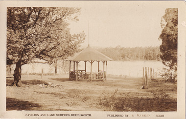
These photographs are of Lake Kerferd and the Pavilion. There are no people in the first image but in the second image there are a man and women sitting on the railing of the pavilion. The Pavilion sits in a picnic ground and there are a few trees around it. Lake Kerferd is significant to Beechworth and the surrounding area because it was the main source of water for the community. In addition, it is also significant because this photograph indicates that it was a popular picnic spot during the beginning of the twentieth century. Sepia rectangular postcard printed on paper 2960.1- Obverse: Pavilion and Lake Kerferd, Beechworth / Published by R Warren / M.5311/ 2960.1- Reverse: POST CARD / Correspondence / Address Only / 2960.2-Obverse: Picnic Grounds, Lake Kerferd, Beechworth / Real Photo Series / M.5949/ 2960.2-Reverse: Published by the Valentine Publishing Co Pty (indecipherable) Queen St (indecipherable) / Valentines / Real Photo Series/ lake kerferd, beechworth, picnic, outing, park, trees, lake, picnic grounds, victoria, district views, pavilion, warren, photograph, 1920 -
 The Beechworth Burke Museum
Postcard - Postcard - Reproduction, c.1930's - 1940's
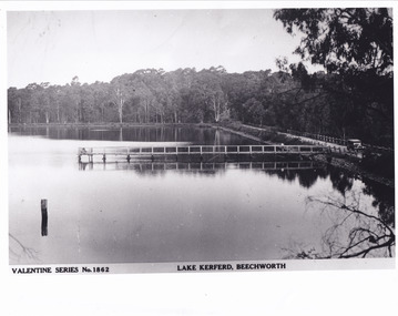
This photograph is a copy of the Valentine series postcard originally produced c.1920. The photograph copy was recorded made c. 1930's - 40's, depicting Lake Kerferd, Beechworth. Lake Kerferd was built in 1862 to assist for gold mining activities as it held the waters of the Hurdle Swamp. The retaining wall built to create Lake Kerferd is depicted in the photograph adjacent to a narrow road, the make of the single automobile shown is consistent with the date recorded. The photograph is socially significant due to the connection of Beechworth in the past, present and future. Originally developed for gold mining activities which is a strong research area as the foundation of many towns in Australia's history. Black and white rectangular photograph printed on matte photographic paper.5461 Obverse: Valentine Series No.1862/LAKE KERFERD, BEECHWORTH 5461 Reverse: BMM2961/5461burke museum, lake kerferd, hurdle swamp, gold mining, beechworth, valentine series postcard, automobile, trees, jetty, reflection, car -
 The Beechworth Burke Museum
Photograph - Photographs, c1900
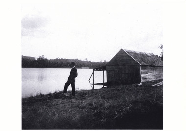
Both of these stereoscopic images depict a man standing by Lake Kerferd in Beechworth. The boathouse is located behind him. Lake Kerferd is significant because it was created in 1862 and Beechworth's main water supply. These images depict how Lake Kerferd was once used for boats because of the boathouse shown in the background of the image. However this boathouse appears to be in poor condition. This could give an indication that either boating was not a popular activity or that this boathouse in particular was not well looked after. Black and white photograph mounted on cardA03074.2 obverse: Lake Kerferd/ Beechworth/boathouse, lake, lake kerferd, man, stereoscopic, beechworth lake, beechworth, victoria, trees, boat, wooden house -
 Orbost & District Historical Society
pictorial magazine, From Drought to Deluge '98, 1998
This magazine cost $2.50 and was produced to support the East Gippsland Red Cross Flood Appeal. Following heavy rain in East Gippsland in June, 1998, major flooding occurred in the Mitchell, Nicholson, Tambo, Snowy, Brodribb and Bemm Rivers. Other streams in the region also experienced high flows during this time. Probably the most severe direct impacts of the floods were to the rural sector.This magazine is a contemporary record of a significant local event.Two copies of a magazine pictorial of the floods of 1998. Photos are black and white. They are of Bairnsdale, Orbost, Lakes Entrance, Raymond Island, Bemm River, Bruthen , Tambo and Cabbage Tree. flood-1998 flood-east gippsland disaster-floods -
 Orbost & District Historical Society
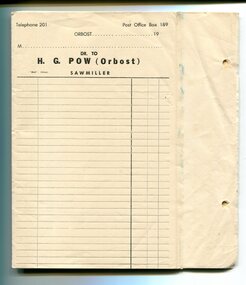
invoice forms, Snowy River Mail as "Mail" Print, 19th century
These invoice forms were to be used by Hector G. Pow's Sawmiller Company in Newmerella ( Henty's & Pow). Pow's had a mill at Cabbage Tree as well. The mill is currently owned by Mectec.Orbost has historically been based on the timber industry, but that industry has declined considerably over the last 20 years. The number of locals involved in the timber industry has declined and many of the mills have closed. This item reflects a time when that industry was a significant contributor to the economy of the district.Unused invoice forms for H.G.Pow Orbost Sawmillers. They are white paper with black print and lines. On the right hand side are two small holes for filing. The page is perforated with carbon underneath to provide two copies - one for filing and one for the customer. At the top of each page is "Telephone 201 Post Office 189 Orbost" and a line for the date. Below this is a line for the customer's name and "Dr to H.G. Pow (Orbost) Sawmiller". There are columns for item descriptions and costs.h.g.pow sawmills timber-orbost -
 Orbost & District Historical Society
map/poster, Victorian Government Printer, 22.4.1926
The Department of Crown Lands and Survey was originally established in 1857 as part of the Board of Land and Works. In 1964 it ceased to be controlled by the Board. The Department functioned for almost twenty more years before being combined with other Ministries to form the Department of Conservation, Forests and Land. It was responsible for the management of the State's Crown land and pastoral estates. This map was used by Don Mehlert after 1928. The VERMIN AND NOXIOUS WEEDS ACT 1928 was an Act to consolidate the Law relating relating to Vermin and Noxious Weeds. E. J. E. G. Pemberton who published this poster was Superintendent of Field Staff, Dept. of Lands and Survey. This map and posters are significant records of early settlement history in Murrangower, between Cabbage Tree and Orbost,A paper map of Murrangower showing settlement subdivisions. This is glued onto the back of four overlapping cloth poster of "Notices of Vermin Destruction". All print is black."DON MEHLERT" in black pen. Pike's block shaded in blue. School site marked in blue pencil. on poster "MURRANGOWAR" along side.map-murrangower poster-vermin-and-noxious-weeds murrangower-settlement -
 Orbost & District Historical Society
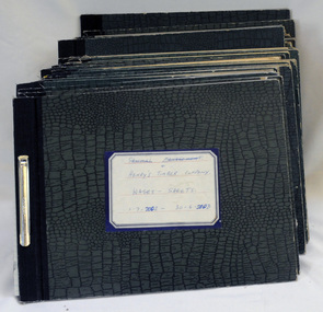
wages sheets, 1.7.1970 - 30.6.1988
These forms were used by Hector G. Pow's Sawmiller Company in Newmerella ( Henty's & Pow). Pow's had a mill at Cabbage Tree as well. Hec Pow and his father sold the Newmerella mill to Henry Silverberg and Les Grace. The mill is currently owned by Mectec.Orbost has historically been based on the timber industry, but that industry has declined considerably over the last 20 years. The number of locals involved in the timber industry has declined and many of the mills have closed. This item reflects a time when that industry was a significant contributor to the economy of the district.Thirty dark green hard-backed folders with black spines and silver metal fastenings, containing wages sheets for employees of POW's Sawmills P/L. All have labels with "POW's Sawmills P/L" and dates of wages sheets included. They are hand-written. -
 Orbost & District Historical Society
black and white photograph, late 19th century / early 20th century
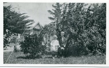
The first settler to occupy the Marlo township area was James Stirling around the year 1875. He built a bark hut on the bluff that had two rooms, bark walls, earthen floors and a shingle roof. By 1884, this structure had expanded to a 9 roomed accommodation house and in 1886 became the Marlo Hotel when a liquor license was granted. The Governor-in-Council declared Marlo to be a township on 18 February 1889. During May 1889, the government surveyor, E.L. Bruce set out 19 sections of the new township, with the first sales of subdivided land occurring the following May. At this time, Stirling's Marlo Hotel was the unofficial hub for the community. It was a general store, accommodation house and the unofficial post office, with settlers taking turns in bringing the mail from Orbost or Cunningham. This continued until Aug 1942, and in 1969 was located in a house adjacent to the Marlo Hotel, before being transferred to the Marlo General Store in this year. The official Post Office List states the Marlo Post Office opened around 1902. in 1925, the "Marlo House" (a nine room accommodation guest house) was granted a liquor licence. The "Marlo House" became "The Marlo Hotel". The Marlo Hotel was popular with many Orbost and district settlers, who travelled to Marlo by horseback or buggy. In the early 20th century the hotel advertised itself as " Under Vice-Regal Patronage. Situated on High Cliff, fronting Ocean, Lakes and Snowy River. Those in search of Health, Rest and Sport should visit Marlo. Boating, Fishing, Shooting, Bathing, Golf. Comfort and Convenience at Marlo Hotel, near Orbost, East Gippsland. Nixon's Cars would meet the train at at Orbost. Fare---6s single, 12s return. Telephone No. 1, Marlo. S, P, STEWART, Proprietor." The Marlo Hotel, perched on the hill overlooking the estuaries and the entrance is a significant building in Marlo. Established in 1886, it has been operating for over 120 yearsAn original black / white photograph and a black / white copy of a party being held under trees on the lawn of the Marlo Hotel. It is a postcard with advertising of Marlo on the back.on back - "Where to spend your holiday - Marlo" on front - "Vice Regal Party at Hotel, Marlo"marlo-hotel -
 Orbost & District Historical Society
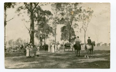
black and white photograph, C 1910
The first meeting to form an Agricultural society in Orbost was convened by the then Orbost Progress Association and held in the Mechanics Hall on Saturday, 10th October 1891. Its first show was held on 3rd March 1904...on a site alongside the Bonang Road where the present Golf Club stands. It is currently held at the Recreation Reserve at Newmerella. This item is associated with the Orbost Agricultural Society 's Annual Show which has been a major event in Orbost for over a century. Agricultural shows are an important part of cultural life in small country towns and the Orbost Show is an integral part of Orbost 's agricultural history. Horse riding as transport, a recreational and sporting activity has always played a significant role in the social history of Orbost. A small black / white photograph of several small groups of people at an agricultural show. Some are walking, others are on horseback and some are in carts / coaches. They are in an open grassed area with trees in the background.equestrian orbost-agricultural-show recreation -
 Orbost & District Historical Society
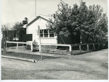
black and white photograph, 1960s - 1970s
This photograph shows the former Orbost Police Station in Wolseley Street before it was demolished and a new larger brick building was built behind it in Lawson Lane - late 1980s.This is a pictorial record of a significant community building no longer existing.A large black / white photograph of the Orbost township police station. It is a weatherboard building surrounded by trees. A sign "POLICE" is hanging from a pole.on back - " Orbost Police Station in Wolseley Street, Donated by Debbie Hall 31/8/94"orbost-police-station -
 Orbost & District Historical Society
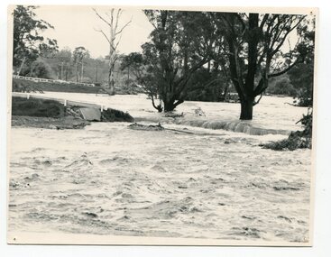
black and white photograph, February, 1971
This photograph shows the floodwaters during the 1971 flood at Orbost. The two mahogany trees in the photograph stopped the Snowy River from changing its course. The 1971 flood was the the worst flood on record. At Jarrahmond it was at least 11 metres and up to one and a half kilometres wide on the flats causing enormous damage to the flood plain. Records say that "The brown floodwater stain in Bass Strait could be seen from passing airliners." Considerable damage was done to railway infrastructure, roads and farms. More information from the APRIL, 2008 newsletter by John Phillips. (see orbosthistory.com.au)This is a pictorial record of a significant event in the history of floods in Orbost.A black / white photograph of raging floodwaters at the bottom of the Orbost township.orbost-flood-1971 -
 Orbost & District Historical Society
black and white photograph, 1919
Ian and Jean McDonald are the children of Mr and Mrs Norman McDonald of 42 Gladstone Street, Orbost. This photograph was taken in late January 1919 on the occasion of Jean's first day of school at the house of John Rowe, a former headmaster, who then lived opposite the school. Norman Alexander McDonald was a book-keeper at Macarthur‟s and was very musical. He was proprietor of the Capitol Cafe, Nicholson Street, Orbost, selling the business to Mr Coad on 4th December 1947.This is a pictorial record of a significant event in the life of the McDonald family of early Orbost.A black / white photograph of two children, holding their hats , standing in front of a tree outside a school fence. on back - "Ian & Jean McDonald opposite the school"mcdonald-ian mcdonald-jean orbost-education rowe-john -
 The Beechworth Burke Museum
Animal specimen - Musk Lorikeet, Trustees of the Australian Museum, 1860-1880
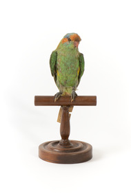
The Musk Lorikeet is a bright coloured bird which commonly resides in south-eastern Australia. They also live in the drier areas of Tasmania. These birds are common in suburban and urban areas and are nomadic, meaning they are willing to travel significant distance to find flowering trees. The bright colours of this Lorikeet enable the bird to camouflage in dense foliage. This specimen is part of a collection of almost 200 animal specimens that were originally acquired as skins from various institutions across Australia, including the Australian Museum in Sydney and the National Museum of Victoria (known as Museums Victoria since 1983), as well as individuals such as amateur anthropologist Reynell Eveleigh Johns between 1860-1880. These skins were then mounted by members of the Burke Museum Committee and put-on display in the formal space of the Museum’s original exhibition hall where they continue to be on display. This display of taxidermy mounts initially served to instruct visitors to the Burke Museum of the natural world around them, today it serves as an insight into the collecting habits of the 19th century.This specimen is part of a significant and rare taxidermy mount collection in the Burke Museum. This collection is scientifically and culturally important for reminding us of how science continues to shape our understanding of the modern world. They demonstrate a capacity to hold evidence of how Australia’s fauna history existed in the past and are potentially important for future environmental research. This collection continues to be on display in the Museum and has become a key part to interpreting the collecting habits of the 19th century.The Musk Lorikeet is a beautiful species of parrot with mainly green plumage. it has a patch of yellow on the side of the breast which has faded to a grey on this specimen. This could be due to the impact of the taxidermy process or a product of time. The bird has an orange patch on the forehead and band through he eye to the ear coverts which has also faded from a brighter red colour. The crown of this bird is grey and would have been a grey-blue colour originally.87a / (89a)? Musk Lorikeet / See catalogue, page 24. /taxidermy mount, taxidermy, animalia, burke museum, beechworth, australian museum, skin, reynell eveleigh johns, bird, australian birds, lorikeet, musk lorikeet -
 The Beechworth Burke Museum
Animal specimen - Musk Lorikeet, Trustees of the Australian Museum, 1860-1880
The Musk Lorikeet is a bright coloured bird which commonly resides in south-eastern Australia. They also live in the drier areas of Tasmania. These birds are common in suburban and urban areas and are nomadic, meaning they are willing to travel significant distance to find flowering trees. The bright colours of this Lorikeet enable the bird to camouflage in dense foliage. This specimen is part of a collection of almost 200 animal specimens that were originally acquired as skins from various institutions across Australia, including the Australian Museum in Sydney and the National Museum of Victoria (known as Museums Victoria since 1983), as well as individuals such as amateur anthropologist Reynell Eveleigh Johns between 1860-1880. These skins were then mounted by members of the Burke Museum Committee and put-on display in the formal space of the Museum’s original exhibition hall where they continue to be on display. This display of taxidermy mounts initially served to instruct visitors to the Burke Museum of the natural world around them, today it serves as an insight into the collecting habits of the 19th century.This specimen is part of a significant and rare taxidermy mount collection in the Burke Museum. This collection is scientifically and culturally important for reminding us of how science continues to shape our understanding of the modern world. They demonstrate a capacity to hold evidence of how Australia’s fauna history existed in the past and are potentially important for future environmental research. This collection continues to be on display in the Museum and has become a key part to interpreting the collecting habits of the 19th century.The Musk Lorikeet is a beautiful species of parrot with mainly green plumage. It has a patch of yellow on the side of the breast which has faded to a grey on this specimen. This could be due to the impact of the taxidermy process or a product of time. The bird has an orange patch on the forehead and band through he eye to the ear coverts which has also faded from a brighter red colour. The crown of this bird is grey and would have been a grey-blue colour originally.88a / Musk Lorikeet / See Catalogue, page 24. /taxidermy mount, taxidermy, animalia, burke museum, beechworth, australian museum, skin, reynell eveleigh johns, bird, australian birds, lorikeet, musk lorikeet -
 The Beechworth Burke Museum
Photograph, c. 1902
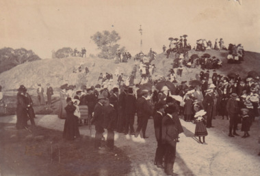
... on the Indigo Shire’s Significant Tree Register. entertainment album ...Taken in c. 1902, depicted is a group of adults and children dressed in formal clothing, with some of the women in the crowd carrying parasols, standing and sitting around and upon the rock at Queen Victoria Park on the Ford Street side of the park. This group is celebrating the official opening of the park. On top of the rock is a gas lamp post.Originally known as the Beechworth Botanical Gardens, the Queen Victoria Park features a extensive collection of historic trees and plants, which have been listed on the Indigo Shire’s Significant Tree Register. Sepia rectangular photograph printed on matte photographic paperReverse: 3716 (in black pen)/ 97.2273 (in pencil)/entertainment album, beechworth, queen victoria park, gardens & parks, opening, burke museum -
 The Beechworth Burke Museum
Photograph, c. 1905
... Park features a extensive collection of historic trees ...Taken in c. 1905, depicted is a large group of children and adults dressed in formal attire sitting and standing upon a granite rock that is located in the centre of Queen Victoria Park. In front of the group is a wooden picket wire fence that sides the granite rock. On top of the rock is a gas lamp post.Originally known as the Beechworth Botanical Gardens, the Queen Victoria Park features a extensive collection of historic trees and plants, which have been listed on the Indigo Shire’s Significant Tree Register.Black and white rectangular reproduced photograph printed on matte photographic paperReverse: 6956 (in pencil)/ ©/ DONALD HAYES/ BEECHWORTH (stamped in orange ink)/entertainment album, burke museum, beechworth, queen victoria park, park