Showing 1987 items
matching victoria bridge
-
 Flagstaff Hill Maritime Museum and Village
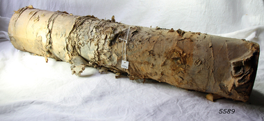
Functional object - Paper, circa 1908
This roll or reel of paper was part of a consignment carried as cargo of the Falls of Halladale. The iron-hulled, four-masted barque, the Falls of Halladale, was a bulk carrier of general cargo. She left New York in August 1908 on her way to Melbourne and Sydney. In her hold, along with 56,763 tiles of unusual beautiful green American slates (roofing tiles), 5,673 coils of barbed wire, 600 stoves, 500 sewing machines, 6500 gallons of oil, 14400 gallons of benzene, and many other manufactured items, were 117 cases of crockery and glassware. Three months later and close to her destination, a navigational error caused the Falls of Halladale to be wrecked on a reef off the Peterborough headland at 3 am on the morning of the 15th of November, 1908. The captain and 29 crew members all survived, but her valuable cargo was largely lost, despite two salvage attempts in 1908-09 and 1910. ABOUT THE ‘FALLS OF HALLADALE’ (1886 - 1908) Built: in1886 by Russell & Co., Greenock shipyards, River Clyde, Scotland, UK. The company was founded in 1870 (or 1873) as a partnership between Joseph Russell (1834-1917), Anderson Rodger and William Todd Lithgow. During the period 1882-92 Russell & Co., standardised designs, which sped up their building process so much that they were able to build 271 ships over that time. In 1886 they introduced a 3000 ton class of sailing vessel with auxiliary engines and brace halyard winches. In 1890 they broke the world output record. Owner: Falls Line, Wright, Breakenridge & Co, 111 Union Street, Glasgow, Scotland. Configuration: Four masted sailing ship; iron-hulled barque; iron masts, wire rigging, fore & aft lifting bridges. Size: Length 83.87m x Breadth 12.6m x Depth 7.23m, Gross tonnage 2085 ton Wrecked: the night of 14th November 1908, Curdies Inlet, Peterborough south west Victoria Crew: 29 The Falls of Halladale was a four-masted sailing ship built-in 1886 in Glasgow, Scotland, for the long-distance cargo trade and was mostly used for Pacific grain trade. She was owned by Wright, Breakenridge & Co of Glasgow and was one of several Falls Line ships, all of which were named after waterfalls in Scotland. The lines flag was of red, blue and white vertical stripes. The Falls of Halladale had a sturdy construction built to carry maximum cargo and able to maintain full sail in heavy gales, one of the last of the ‘windjammers’ that sailed the Trade Route. She and her sister ship, the Falls of Garry, were the first ships in the world to include fore and aft lifting bridges. Previous to this, heavily loaded vessels could have heavy seas break along the full length of the deck, causing serious injury or even death to those on deck. The new, raised catwalk-type decking allowed the crew to move above the deck stormy conditions. This idea is still used today on the most modern tankers and cargo vessels and has proved to be an important step forward in the safety of men at sea. On 4th August 1908, with new sails, 29 crew, and 2800 tons of cargo, the Falls of Halladale left New York, bound for Melbourne and Sydney via the Cape of Good Hope. The cargo on board was valued at £35,000 and included 56,763 tiles of American slate roofing tiles (roof slates), 5,673 coils of barbed wire, 600 stoves, 500 sewing machines, 6,500 gallons of oil, 14,400 gallons of benzene, plumbing iron, 117 cases of crockery and glassware and many other manufactured items. The Falls of Halladale had been at sail for 102 days when, at 3 am on the night of 14th November 1908, under full sail in calm seas with a six knots breeze behind and misleading fog along the coast, the great vessel rose upon an ocean swell and settled on top of a submerged reef near Peterborough on the south-west Victoria’s coast. The ship was jammed on the rocks and began filling with water. The crew launched the two lifeboats and all 29 crew landed safely on the beach over 4 miles away at the Bay of Islands. The postmistress at Peterborough, who kept a watch for vessels in distress, saw the stranding and sent out an alert to the local people. A rescue party went to the aid of the sailors and the Port Campbell rocket crew was dispatched, but the crew had all managed to reach shore safely by the time help arrived. The ship stayed in full sail on the rocky shelf for nearly two months, attracting hundreds of sightseers who watched her slowly disintegrate until the pounding seas and dynamiting by salvagers finally broke her back, and her remains disappeared back into deeper water. The valuable cargo was largely lost, despite two salvage attempts in 1908-09 and 1910. Further salvage operations were made from 1974-1986, during which time 22,000 slate tiles were recovered with the help of 14 oil drums to float them, plus personal artefacts, ship fittings, reams of paper and other items. The Court of Marine Inquiry in Melbourne ruled that the foundering of the ship was entirely due to Captain David Wood Thomson’s navigational error, not too technical failure of the Clyde-built ship. The shipwreck is a popular site for divers, about 300m offshore and in 3 – 15m of water. Some of the original cargo can be seen at the site, including pieces of roof slate and coils of barbed wire. The roll of paper is an example of cargo brought to Australia in the early 20th century. It is also significant for its association with the Falls of Halladale shipwreck, which is listed on the Victorian Heritage Register (No. S255). She was one of the last ships to sail the Trade Routes. She is one of the first vessels to have fore and aft lifting bridges. She is an example of the remains of an International Cargo Ship and also represents aspects of Victoria’s shipping industry. The wreck is protected as a Historic Shipwreck under the Commonwealth Historic Shipwrecks Act (1976).Roll of paper. Paper has remains of a wooden peg up through the centre and a lot of sedimentation. This roll was recovered from the wreck of the Falls of Halladale. It was part of a large consignment of paper listed as part of the cargo manifesto.flagstaff hill, warrnambool, shipwrecked coast, flagstaff hill maritime museum, maritime museum, shipwreck coast, flagstaff hill maritime village, great ocean road, falls of halladale, shipwreck peterborough, 1908 shipwreck, great clipper ships, russell & co., paper, reel, roll, paper reel, paper roll, cargo, consignment -
 Bendigo Military Museum
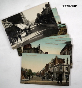
Postcard - POSTCARD, ALDERSHOT, UK, Valentine's Series, c 1914 - 1918
R..H. Baron took leave from Herdcott Camp between 4.10.19918 and 8.10.1918 to visit Aldershot. See Catalogue No. 7743 for leave pass details. Relatives lived in the Aldershot area. Part of the 'Robert H. Baron', No.3596 and Cooper Collections. See Catalogue No. 19819 for details of Baron's service.1. Coloured street scene with buildings, groups of people and horse drawn transport. 2. Coloured street scene with buildings, groups of people and horse drawn transport. 3. Coloured street scene with buildings, groups of people. 4. Coloured scene features a canal with boat, tow path, bridge and house. 5. Coloured, Band marching down a street. Spectators lining the road. Church in background. 6. Coloured Group of soldiers in uniform marching along the road. Spectators, church in background. 7. Coloured statue of a man on a horse. Statue located on a hill 8. Coloured scene of gardens surrounded by buildings and a church. Groups of women. 9. Coloured - Large building with a clock tower. 10. Coloured column of uniformed soldiers on horseback. Buildings lining road. Horse drawn transport sharing road. 11. Coloured street scene with red brick building and pedestrians. 12. Coloured Monument with inscription. Buildings in background. 13. Black and wgite street scene. Street lined with buildings. Horse drawn transport. Pedestrians.1. High Street, Aldershot. 2. Wellington Street, Aldershot. 3. Union Street, Aldershot. Handwritten in black ink on back: (Notice how narrow the streets are). 4. Wharf Bridge, Farnborough Road, Aldershot. Handwritten in black ink on back: "I was all over these places with Uncle. I had a good time in Aldershot, Bob. 5. Wellington Avenue (Church Parade), Aldershot. Handwritten in black ink: 'One of the Aldershot bands', R.H. Baron.' 6. Queens Avenue and St. George's Church, Aldershot. Handwritten in black ink on back: 'Soldiers going to church". 7. Wellington Monumental, Aldershot. Handwritten on back in black ink: 'I was right up around this place!' 8. Municipal Gardens, Aldershot. Handwritten on back in black ink: 'This place is very pretty, Bob'. 9. Cambridge Hospital, Aldershot. Handwritten on back in black ink "This is a fine place!". 10. Hospital Hill, Aldershot. 11. Smith Dorrien Home, Aldershot. Handwritten on back in black ink. 'I was all over Aldershot with Uncle. I have saw all these places. Bob.' 12. R.A.M.C. Memorial, Aldershot. 13. Victoria Rd, Aldershot.robert h. baron, cooper collection, aldershot uk, postcards -
 Warrnambool and District Historical Society Inc.
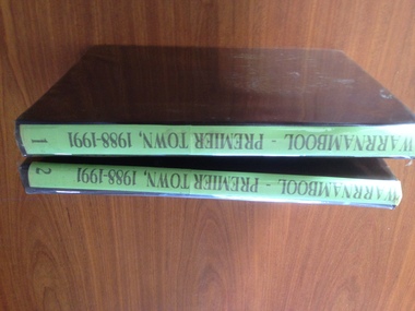
Book - Album, 1988-1991 Premier Town Volume 2, Circa 1988
The Premier towns is an award given by the Victorian state Government. It recognises positive actions by regional communities to protect and enhance their local environment. It is based on criteria relating to litter prevention and waste management, environmental and heritage management as well as activities among community groups and leadership. The following is taken from Hansard at the announcement of the awards in 1988 That the Senate- (a) congratulates the Mayor, Councillors, the Premier Town Committee, and the people of the City of Warrnambool, Victoria, for their achievement, on Saturday, 20 November 1988, in taking out the Victorian `Premier Town Award' for an unprecedented third time; (b) congratulates the business people of Warrnambool for their efforts in helping the city to win the Victorian Industrial and Commercial Development Award, including a special award for coastline preservation and studies This album is significant in that it documents an important award to the City of Warrnambool. It is also a comprehensive pictorial record of Warrnambool as it was in 1988.Volume 2. Covers Warrnambool rivers, bridges, coastal features, places of learning, clubs and sporting facilities and historical and general interest all of which have played an important role in the development of and history of the city and lives of its people.Soft brown vinyl cover with plastic cover. Pages are dark cream cover paper. A sticker with the Warrnambool Premier Town logo is inside the front cover. The album consists of photographs of various buildings and streetscapes with relevant descriptive text.Sticker inside front cover, Mr J Gietz Po Box 1007 Warrnambool Vic 3280. warrnambool, ideal town 1988-1991, victoria’s bicentennial premier town premier town awards -
 Warrnambool and District Historical Society Inc.
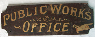
Sign - Public Works Office
This sign points has two different messages. The first states Public Works Office, which was operational in Victoria between 1855 and 1987 dealt with many aspects of the states infrastructure. It had many different reponsibilities and roles from building government accommodation and fit out of buildings, licences for unused roads and water ways, main roads and bridges, ports and harbour,and water supplies. Much of this work was managed through local offices such as the one at Warrnambool. The sign on the reverse which states Witnesses Waiting Room relates to the court house which is where this sign originated.The Warrnambool court house was built in 1870-71 by the Victorian Public Works department and it is possible that this sign relates to that period.It is one of a number of public buildings built in the period 1870-1890 including the Police station and stables and police quarters, the Post Office and drill Hall , all in the same vicinity. This building reflects the growth of the town and also the importance it held at the time from a state level. The building while no longer used as a court house is a building of significance to Warrnambool as well as to the state of Victoria, being one of six around the state which were built in free classical style. This sign denotes the waiting room for witnesses which was situated on the western side of the building.A tangible link which provides historical and social significance to Warrnambool.Rectangular wooden sign with rounded corners. There is text on both sides painted in gold paint with shadow in black. One side is a darker brown stain . There are screw holes in each corner.and one hole on left middle of sign. Rounded edge on one side.Side 1:Witnesses Waiting Room Side 2:Public Works Office.warrnambool, warrnambool court house, public works department warrnambool -
 Warrnambool and District Historical Society Inc.
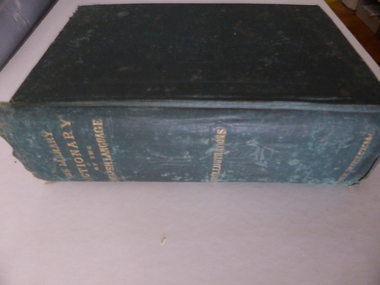
Book, The library dictionary of the Eng language
This dictionary belonged to John Brass, an early settler in South Warrnambool. He owned several block of land and operated a lighterage business with John Young. As a lighterman and boatman he was well-known in Warrnambool. He was drowned in March 1895 while attempting to cross a temporary foot bridge across the Merri River. His house (probably in Stanley Street) was built in 1868 and remained as an interesting example of a lighterman’s cottage until1974. The dictionary probably became the property of W. Macdonald after John Brass’ death. No information has been found on this W. Macdonald. This book is of interest as it belonged to John Brass, an important early settler in South Warrnambool. This is a hard cover book of 974 pages. The cover is green with embossed patterning and lettering on the front cover and gold lettering on the spine. The book has a Preface, a Contents page, the Dictionary entries and an Appendix. There are many illustrations, from engravings on wood, scattered throughout the text. The cloth binding is coming loose and there are several loose pages. The last page is missing. The inscriptions are written in pencil and in blue ink and there are red stamps of John Brass. The cover is stained and faded. ‘John Brass, South Warrnambool, Victoria, Aust- 1893’ ‘June 5 x 6 x 93’ ‘J.Brass, Jetty’ Stamps – ‘John Brass, South Warrnambool’ ‘W.J. Macdonald, Moyston, Dec.23-11-95’ ‘W.J.McDonald’ john brass, history of south warrnambool, w. macdonald (moyston), warrnambool’s maritime history -
 Warrnambool and District Historical Society Inc.
Document, Wollaston sale, 1919
This is a poster advertising the sale of part of the Wollaston Estate in Warrnambool in 1919. The sections for sale were Allotments 1, 18 and 19 which included the Wollaston Homestead. The original Wollaston property of 679 acres was selected by Thomas Manifold in the late 1840s. This land, on the northern side of the Merri River, near the Woodford Road was three kilometres from the Warrnambool town. The first farmer we know who leased the property was William Simpson. Walter Manifold inherited the property and he took it over in 1884. The swing bridge he built in 1890 still stands today. In 1919 the Closer Settlement Board of Victoria acquired Wollaston and 17 lots were sold to returned soldiers for farming purposes. By 1930 there were only five soldier settlers remaining. In 2009 further subdivision took place with lots sold for residential purposes. The homestead allotments were sold separately in 1919 with various owners of the homestead itself recorded since that time. This poster is of interest as it shows the areas of the Wollaston Estate which were sold in 1919. The history of this estate is well-documented and of importance in the history of Warrnambool. This is a sheet of paper with red and black printing and a map of the Wollaston Estate which is photo-lithographed. The sheet has been folded three times. It has some small tears at the top of the page. wollaston, history of warrnambool, walter manifold -
 Kiewa Valley Historical Society
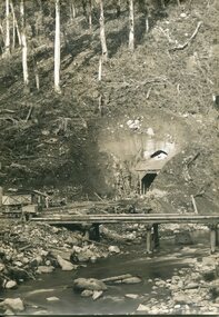
Photographs – SECV – Clover Power Station
The Junction Dam and Clover Dam Power Station, stages of the Kiewa Hydro-Electric Scheme, were needed to meet the increased power demands of the wartime industry in Victoria. Clover added 26 megawatts to the grid. Junction Dam was completed and ready to hold water by September 1943, but was emptied in December 1943 and not filled again until May 1944. Construction of Clover Power Station commenced in July 1941 and both turbines were in service by May 1945.Clover Power Station and Junction Dam were part of the Kiewa Hydro Electric Scheme constructed by the State Electricity Commission of Victoria.Set of 22 black and white photographs taken by the official SECV photographer who gave each photo a number prefixed by K (for Kiewa) K60 -no date- A bridge and entrance to tunnel K519 -no date- Welding steel lining in the tunnel K531 –no date- Construction on the Kiewa Scheme (tunnel in background K821 – no date- Bogong Village, early days K928 -15 Oct 1942- Construction Clover Power Station K947 -26 Oct 1942- Construction Clover Power Station K948 -26 Oct 1942- Construction Clover Power Station K949- 26 Oct 1942- Clover Camp in background K950 -26 Oct 1942- Construction Clover Power Station K955 -27 Oct 1942- Constructing the bridge at Clover K1102 -7 April 1943- Inlet pipe to power station K1179 –no date- Clover Power Station K1187 – no date- Clover Power Station K1189 -24 June 1943- Part of the spiral casing 1199 -7 July 1943- Clover Power Station K1201 -7 July 1943- Clover Power Station K1231 -26 July 1943- Gantry crane for Clover Power Station K1308 -6 Sept 1943- Spiral casing K1334 -6 Oct 1943- Lake Guy. Bogong Village in background K1342 -29 Oct 1943- Power station under construction K1365 -19 Nov 1943- Power station under construction K1366 -19 Nov 1943- Gantry crane for Clover Power Station On the back- each photograph has a handwritten reference number starting with K and the date stamped or written (see above)secv; kiewa hydro electric scheme; official photographer; junction dam; clover power station; bogong; -
 Kiewa Valley Historical Society
Photograph - Folder of Photographs (KVHS 1150 A - F) – Photocopied set of black and white photographs from the display folder (pages 1 - 8) put together by KVHS to document life on the Kiewa Valley Hydro-electric Scheme
Although the Kiewa Hydro-Electric Scheme was first proposed in 1911, construction did not commence until 1938. As part of the push to cut electricity costs and diversify supply, the Victorian Government (circa 1930) initiated the conversion from primarily brown coal supply to hydro – electricity. Field investigations during the 1940’s resulted in a new proposal for a scheme that had more than double the capacity of the 1938 scheme. The Kiewa Hydroelectric Scheme became the largest scheme of its kind in the State Of Victoria and the second largest scheme in Australia. The number of personnel involved in the planning and construction of the scheme increased dramatically. During the late 1940’s, most activity centred around the construction of the West Kiewa Power Station, Rocky Valley Reservoir, McKay Creek Power Station and the Bogong Creek Aqueduct.A common thread across all the larger hydro scheme constructions was the need for workers, both qualified and unqualified who came from around the world seeking a new life for themselves and their families. New accommodation and facilities were required for the army of workers engaged in construction in often remote and wild areas. The SEC had a high demand for timber, and set up the first of a number of sawmills at Bogong Creek in 1939 and set up the first hardwood logging in the headwaters of the Kiewa River. These new ‘towns’ such as Mt Beauty and Bogong, survived, serving the needs of operational personnel and their families, and expanding with growth of new industries. Mount Beauty, and to a lesser extent Bogong, are among these places. Large A3 size spiral bound display folder containing 21 of 58 pages of photocopied black and white photographs of various aspects of the early days of the Kiewa Valley Hydro-electric scheme including equipment, various work sites and photographs of workers and their families. 1-Front page; 2-Security gate at Mt Beauty Camp; 3-Channel 1 on East Kiewa River; 4-Junction Dam – Diversion Tunnel Inlet; 5-Sawmill; 6- Homan’s Gap Sawmill; 7 Junction Dam: 8-Homan Dam Site-Diamond Drilling on River Buttress; 9- Homan Dam Site View Upstream 10-Homan Dam Investigation Camp 1-Windsor & Newton Visual Diary 60 sheet (120 pages) 11’ x 14’ 280 x 356mm 110 GSM Acid Free Drawing Paper 2-1940-Security Gate on Mt Beauty side of Kiewa River bridge. Part of old Mt Beauty camp and mess in background 3- STATE ELECTRICITY COMMISSION OF VICTORIA Date; 11.3.40 Time: 10.30am No K35 Kiewa Hydro Electric Works. Diverting East Kiewa River into Channel Page number 1 4-STATE ELECTRICITY COMMISSION OF VICTORIA Date: 5.4.40 Time: Noon No K58 Kiewa Hydro Electric Works. Junction Dam – Diversion Tunnel Inlet – Normal Flow Page number 2 5- STATE ELECTRICITY COMMISSION OF VICTORIA Date: 19.8.42 Time: 2.30pm No K883 Kiewa Hydro Electric Works. Sawmill – General View Page number 3 6- STATE ELECTRICITY COMMISSION OF VICTORIA Date: 12.1.42 Time: 2.00pm No K540 Kiewa Hydro Electric Works. Homan’s Gap Sawmill – General View Page number 4 7- STATE ELECTRICITY COMMISSION OF VICTORIA Date: 12.1.42 Time: 2.00pm No K540 Kiewa Hydro Electric Works. Junction Dam – General View looking upstream Page number 5 8- STATE ELECTRICITY COMMISSION OF VICTORIA Date: 16.11.45 Time: 10.32amm No K52153 Kiewa Hydro Electric Works Homan Dam Site – Diamond Drilling on River Buttress Page number 6 9-STATE ELECTRICITY COMMISSION OF VICTORIA Date: 15.1.45 Time: 4.10pm No K1781 Kiewa Hydro Electric Works Homan Dam Site – View Upstream Page number 7 10- STATE ELECTRICITY COMMISSION OF VICTORIA Date: 15.1.45 Time: 4.10pm No K1781 Kiewa Hydro Electric Works Homan Dam Investigation Camp 1944 – 1945 Page number 8 secv; kiewa hydro electric scheme; mt beauty; bogong; construction work; -
 Kiewa Valley Historical Society
Photograph - Folder of Photographs – Photocopied set of black and white photographs (pages 9 - 18) from the display folder put together by KVHS to document life on the Kiewa Valley Hydro-electric Scheme
Although the Kiewa Hydro-Electric Scheme was first proposed in 1911, construction did not commence until 1938. As part of the push to cut electricity costs and diversify supply, the Victorian Government (circa 1930) initiated the conversion from primarily brown coal supply to hydro – electricity. Field investigations during the 1940’s resulted in a new proposal for a scheme that had more than double the capacity of the 1938 scheme. The Kiewa Hydroelectric Scheme became the largest scheme of its kind in the State Of Victoria and the second largest scheme in Australia. The number of personnel involved in the planning and construction of the scheme increased dramatically. During the late 1940’s, most activity centred around the construction of the West Kiewa Power Station, Rocky Valley Reservoir, McKay Creek Power Station and the Bogong Creek Aqueduct.A common thread across all the larger hydro scheme constructions was the need for workers, both qualified and unqualified who came from around the world seeking a new life for themselves and their families. New accommodation and facilities were required for the army of workers engaged in construction in often remote and wild areas. The SEC had a high demand for timber, and set up the first of a number of sawmills at Bogong Creek in 1939 and set up the first hardwood logging in the headwaters of the Kiewa River. These new ‘towns’ such as Mt Beauty and Bogong, survived, serving the needs of operational personnel and their families, and expanding with growth of new industries. Mount Beauty, and to a lesser extent Bogong, are among these places. PHYSICAL: Large A3 size spiral bound display folder containing 21 pages of photocopied black and white photographs of various aspects of the early days of the Kiewa Valley Hydro-electric scheme including equipment, various work sites and photographs of workers and their families. 1-Bridge across Tailrace Channel 1946 2-New Mess building, Mt Beauty 3-Homan’s Gap Saw Mill 4- Diamond Drilling Plant – Big Hill 5-Rocky Valley Camp-Mess Building 6-Parlimentary Party at Rocky Valley 7-No.4 Headrace Tunnel 8- Allis-Chalmers Tractor School 9- SECV Heavy Machinery lined up by road 10- No. 5 Raceline – Balasting Track with improvised truck 1-1946 – Bridge across tailrace channel Page number 9 2-New mess building, Mt Beauty 6.4.46 Page number 10 3- STATE ELECTRICITY COMMISSION OF VICTORIA Date: 10.1.47 Time: 11.40am No K2271 Kiewa Hydro Electric Works Homan’s Gap Saw Mill – Rip Saw Page number 11 4- STATE ELECTRICITY COMMISSION OF VICTORIA Date: 5.10.47 Time: 11am No K4111 Kiewa Hydro Electric Works Diamond Drilling Plant – Big Hill Page number 12 5- STATE ELECTRICITY COMMISSION OF VICTORIA Date: 11.2.48 Time: 3pm No K4277 Kiewa Hydro Electric Works Rocky Valley Camp-Mess Building Page number 13 6- STATE ELECTRICITY COMMISSION OF VICTORIA Date: 15.4.48 Time: 4.30pm No K4397 Kiewa Hydro Electric Works Parlimentary Party at Rocky Valley Page number 14 7- STATE ELECTRICITY COMMISSION OF VICTORIA Date: 22.8.48 Time: 9am No K4668 Kiewa Hydro Electric Works General view of No.4 Headrace Tunnel Page number 15 8-STATE ELECTRICITY COMMISSION OF VICTORIA Date: 5.9.49 Time: 10am No K5180 Kiewa Hydro Electric Works Allis-Chalmers Tractor School – HD 19, Mr I Crossthwaite at Controls Page number 16 9- No markings Page number 17 10- STATE ELECTRICITY COMMISSION OF VICTORIA Date: 7,12.49 Time: 4pm No K5423 Kiewa Hydro Electric Works No. 5 Raceline – Balasting Track with improvised truck. Page number 18 secv; kiewa hydro electric scheme; mt beauty; bogong; construction area -
 Kiewa Valley Historical Society
Photograph - Folder of Photographs – Photocopied set of 10 black and white photographs (pages 19 - 28) from the display folder put together by KVHS to document life on the Kiewa Valley Hydro-electric Scheme
Although the Kiewa Hydro-Electric Scheme was first proposed in 1911, construction did not commence until 1938. As part of the push to cut electricity costs and diversify supply, the Victorian Government (circa 1930) initiated the conversion from primarily brown coal supply to hydro – electricity. Field investigations during the 1940’s resulted in a new proposal for a scheme that had more than double the capacity of the 1938 scheme. The Kiewa Hydroelectric Scheme became the largest scheme of its kind in the State Of Victoria and the second largest scheme in Australia. The number of personnel involved in the planning and construction of the scheme increased dramatically. During the late 1940’s, most activity centred around the construction of the West Kiewa Power Station, Rocky Valley Reservoir, McKay Creek Power Station and the Bogong Creek Aqueduct.A common thread across all the larger hydro scheme constructions was the need for workers, both qualified and unqualified who came from around the world seeking a new life for themselves and their families. New accommodation and facilities were required for the army of workers engaged in construction in often remote and wild areas. The SEC had a high demand for timber, and set up the first of a number of sawmills at Bogong Creek in 1939 and set up the first hardwood logging in the headwaters of the Kiewa River. These new ‘towns’ such as Mt Beauty and Bogong, survived, serving the needs of operational personnel and their families, and expanding with growth of new industries. Mount Beauty, and to a lesser extent Bogong, are among these places. Large A3 size spiral bound display folder containing 21 pages of photocopied black and white photographs of various aspects of the early days of the Kiewa Valley Hydro-electric scheme including equipment, various work sites and photographs of workers and their families. 1-Allis Chalmers Tractor School 2- Gardens outside Administrative Office – Mt Beauty 3- Mt Beauty house – 1950 4-Bridge over Pretty Valley River, Bogong 5-Rocky Valley Spillway Tunnel break through 6-Ni 1 Headrace Tunnel drilling face 7-No 4 Power Station Drilling 8-Clover Dam Flood Waters 9-No1 Head Race Tunnel Portal Building 10-Clover Dam 1-STATE ELECTRICITY COMMISSION OF VICTORIA Date: 5.9.49 Time: 10amm No K5174 Kiewa Hydro Electric Works Allis Chalmers Tractor School Page number 19 2-STATE ELECTRICITY COMMISSION OF VICTORIA Date: 22.2.50 Time: 3.30pm No K5601 Kiewa Hydro Electric Works Gardens outside Administrative Office – Mt Beauty Page number 20 3-Mt Beauty house – 1950 Page number 21 4-STATE ELECTRICITY COMMISSION OF VICTORIA Date: 23.10.50 Time: 11.15am No K6331 Kiewa Hydro Electric Works Bogong-Bridge over Pretty Valley River Page number 22 5-STATE ELECTRICITY COMMISSION OF VICTORIA Date: 23.6.50 Time: 2.30pm No K5844 Kiewa Hydro Electric Works ROCKY VALLEY SPILLWAY TUNNEL BREAK THROUGH Page number 23 6-20/3/52 – No. 1 Headrace Tunnel Drilling face (E.E.E. contract) Page number 24 7-6/6/52 – No 4 Power Station – Drilling Page number 25 8-STATE ELECTRICITY COMMISSION OF VICTORIA Date: 6/6/52 Time: No K7113 Kiewa Hydro Electric Works Clover Dam Flood Waters Page number 26 9-STATE ELECTRICITY COMMISSION OF VICTORIA Date: Oct 1952 Time: No K7239 Kiewa Hydro Electric Works No. 1 HEAD RACE TUNNEL PORTAL BUILDING. Handwritten underneath – This information from Ron White-the later Principal Hydro Engineer of the SEC. Oct 1952 Location incorrect? All work on No 1 had ceased after financial crash of 1951. This photo would refer to No 4 Headrace Tunnel? Page number 27 10-STATE ELECTRICITY COMMISSION OF VICTORIA Date: Jan 1953 Time: No K7307 Kiewa Hydro Electric Works CLOVER DAM Page number 28 secv; kiewa hydro electric scheme; bogong; mt beauty; construction area -
 Kiewa Valley Historical Society
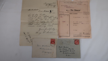
Letters x4 - Re Mrs Stiles
The Advocate was the Catholic newspaper of Victoria. The correspondence is in regard to payment and receipt of the newspapers.4 letters, 2 with envelopes. Chronological order: 1. 11 Jan 1927. From George W. Maddison, Tawonga P. O. Via Dederang to Mrs E. Stiles re money for 'Leader'. 2. 5th Apr. 1928. From Melbourne to Mrs Stiles, Melbourne re Account or "Advocate' 3. late July 1928. From Miss Mary Hessian, Mongans Bridge. Via Wodonga to Mrs Stiles re 'advocate' 4. 28th Jan. 1929 From Chas Martin to Mrs Wallace Bonnie Brae, Bruarong re Mrs Stiles papers. Envelopes: 1. (letter 3)Mrs Stiles c/- Miss Reid 26 Hoddle St. Elsternwick S-4 and in pencil Miss Mary Hessian, Mongan's Bridge, Huon via Wodonga 2. (letter 4) Mrs Wallace, Wallacedale, Kergunyah.mrs e. stiles, mary hessian, george w. maddison, mr wallace, 'advocate' newspaper, chas martin -
 Kiewa Valley Historical Society
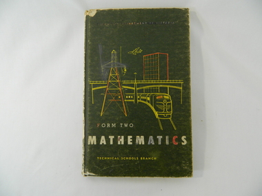
Book - Maths, Wilke and Co P/L, Form Two Mathematics, 1965
Educational book for teaching mathematics in Form 2 in Victoria. Kerrie Davies lived in the Kiewa Valley on a dairy farm.Historical: Comparison of the teaching of Mathematics in Victorian schools. Provenance: Davies family.Dark green hard covered book with sketch of power line, bridge, multi storey building and train in yellow and re. Writing in white.Education Department of Victoria (in white but coloured in) / Form Two / Mathematics / Technical Schools Branch Inside back of cover some scribbled maths. On first page: Kerrie Davieseducation. schools. davies family. mathematics. -
 Kiewa Valley Historical Society
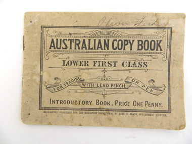
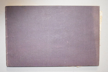
Book - Student Exercise Book for Writing, Australian Copy Book / Lower First Class, 2.10.1906 to 2.7.1907
In 1906 and 1907, students were taught to write with the letters joined. To achieve this booklets were designed to enable the student to copy the example and to repeat this, often to gain perfection. A student could be practising his/her writing while the teacher attended to other students and/or classes.Oliver Fisher lived at Mongan's Bridge a small, remote, rural area in the Kiewa Valley.Soft covered small booklet - grubby blue on back and very faded 'blue' on front with black writing. Held together with 2 staples. "For Tracing with lead pencil or pen. / Introductory Book, Price One penny" Writing surrounded by fancy graphics. Border is thick but not solid black line.Inside book letters have been copied but joined up to practice writing eg. m m m and then mu mu mu Each page is different. On some pages the date has been writteneducation, writing, mongan's bridge, oliver fisher, school -
 Warrnambool and District Historical Society Inc.
Ledger, Letters on Suspension Bridges, 1890s
This book contains information on the building of suspension bridges and dates from the 1890s. It belonged to John William Crawley Junior, an engineer, surveyor and architect in private practice in Warrnambool and also the engineer for the Shire of Warrnambool from 1895 to 1935. The information in the book comes in the form of lectures on suspension bridge making and these were sent to John Crawley by his tutor or coach, Arnold Lilley (Lilly). Arnold Lilley was an Oxford mathematician working in Victoria and it is said that he coached or trained 95% of the municipal surveyors in Victoria in the 1890s. John Crawley has obviously had this material bound into a book and it was passed on to his son, Rolf, who was the engineer for the Shire of Warrnambool from 1935 to 1968. It then came into the possession of Michael Hand who took over the private surveying business of Rolf Crawley in Warrnambool. The Warrnambool and District Historical Society acquired the book, along with several Crawley ledgers and letter books, from the estate of Michael Hand. This book is of interest as it contains lectures and other material on the building of suspension bridges and belonged to John William Crawley Junior, an engineer for the Shire of Warrnambool for 40 years. It also is a memento of the work of Arnold Lilley who produced the material on suspension bridges and coached John Crawley in his surveying studies.This is a hard cover book with a purple cover. The cover is slightly faded. The book contains handwritten material regarding the building of suspension bridges and includes sketches, lectures on suspension bridges and pages with postage stamps on them. There are three loose pages. ‘’Letters on Suspension Bridges Arnold Lilly Esq. Coach J Wm. Crawley Pupil’john william crawley junior, warrnambool, rolf crawley, warrnambool, shire of warrnambool, arnold lilley, teacher of surveying. -
 Port of Echuca
Black and white photograph, Approx. 1975
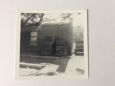
The old brick Murray River Sawmill office was demolished around 1975. This appears to be part of one of the office buildings associated with the sawmill, taken in shadow, with the building well back on the block, on the bridge side. There is a dirt driveway in front of the building and stacks of timber next to the chimney side of the building. Trees are visible behind these stacks of timber. Two stacks of timber (1x 4 blocks high, 1 X 3 blocks high) are in front of the building between the window and the chimney This relates to photographs P000106, P000105 Sawmills in the Echuca area were historically and socially significant being a large employer in the area. The Murray River sawmill was one of the biggest and longest operating sawmills in the area. Black and white photograph of an old Murray River Sawmill building with the chimney to the right and a door and window on the left. Two stacks of timber planks are against the wall between the window and the chimney. A dirt driveway is in front of the building with timber planks edging the driveway.On the reverse in pencil "Old M. R. S. Building well back on the block on the bridge side. Near old offices, also demolished about 1975??" Kodak, , in blue ink "0932"murray river sawmills, echuca, echuca, victoria, pullicino, j (unconfirmed) -
 Port of Echuca
Colour Photograph, Approx.1979
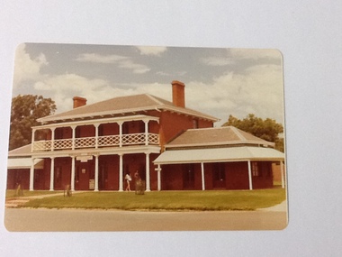
The Bridge Hotel was built by Henry Hopwood, founder of Echuca. The building was in disrepair until it was bought by the Port of Echuca and renovated to be turned into part of the Port of Echuca tourist exhibits and was leased out to be run as a restaurant.The Bridge Hotel is of historical and social significance to Echuca as it was built be Echuca's founder Henry Hopwood. The hotel was situated between the 2 rivers, Murray and Campaspe, where Hopwood ran his punt business, charging people and animals to cross the rivers. The hotel accommodated a variety of paying guest from wealthy squatters to salesmen and general workers. The building was purchased by the Port of Echuca to be part of the tourist attraction. It was extensively renovated to bring it back to its former glory. The Bridge hotel played an important role in the TV series "All the Rivers Run". Colour photograph of the Bridge Hotel, Echuca, after restorations (c.1979)On front of building : Bridge Hotel / Restaurant Printed on reverse:"This paper manufactured by Kodak"bridge hotel, echuca, port of echuca, echuca, victoria -history, henry hopwood -
 Port of Echuca
Photograph, Original photo c.1920
The iron bridge was completed in 1878 and was used by the Deniliquin and Moama Railway company for goods trains only - it was another year before passengers were included in the transport service. On 4 March 1879 citizens of Echuca and Moama stormed the bridge, opened the gates and declared it open for their use.At the turn of the century the railway line carried produce from southern New South Wales & the Riverina to Melbourne, with goods trains being a very important mode to transport. When the bridge was being constructed, six workmen were killed and another maimed when a pile on the Moama bank collapsed. After the storming of the bridge by local people in March 1879 it was declared open for use of local residents traveling between the towns of Echuca and Moama. The bridge was shared by rail, road and pedestrian traffic.An image of the iron bridge at Echuca, taken looking East from Victoria bank.Verso: "Iron bridge"murray river bridge , echuca, murray bridge, echuca, iron bridge, echuca -
 Eltham District Historical Society Inc
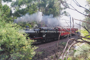
Photograph, Fay Bridge, United Service Station, Main Road, Eltham, 26 August 2019
fay bridge collection, 2019-08-26, hurstbridge wattle festival, k-153, k-class steam locomotive (vr newport workshops), steam locomotive, steamrail victoria -
 Eltham District Historical Society Inc
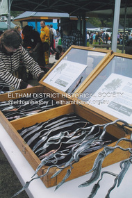
Photograph, Fay Bridge, Ancient Eel trap on the Yarra River at Laughing Waters, Eltham - pre-dating European settlement, 6 September 2023
Laughing Waters is the name for a stretch of the Yarra Valley Parklands consisting of river flats and hilly riparian bushland. With Birrarung (Yarra River) flowing through, Laughing Waters has been an important gathering place for thousands of years. For the Wurundjeri, ‘Garambi Baan’ (the name for Laughing Waters in Woi wurrung) is an important site for growing and harvesting food. Significantly, Wurundjeri iuk (eel) traps remain at Garambi Baan to this day. The Wurundjeri Woi Wurrung People take their name from the Woi wurrung language word ‘wurun’ meaning the Manna Gum (Eucalyptus viminalis) which is common along ‘Birrarung’ (Yarra River), and ‘djeri’, the grub which is found in or near the tree. Wurundjeri are the ‘Manna Gum People’ and their Ancestors have lived on this land for millennia. The site on the Yarra River near the former Morrison property Killeavey was given a language name in 2015 at the instigation of Wurundjeri Elder, Dave Wandin. Garambi Baan means “laughing waters” in the traditional language, Woi wurrung. The site at Warrandyte was rediscovered by Campbell Beardsell OAM in 2007 and is one of only a few known remaining iuk (eel) traps on Country once found the length of the Birrarung (Yarra) and the Maribyrnong. Original Indigenous aquacultural infrastructure was dismantled, taken away from sites and used to build houses, fords and roads by Europeans. The difficult and restricted access to this site is thought to be one of the reasons for its survival. The iuk trap is located within lands managed by Parks Victoria. The Narrap team in partnership with Parks Victoria and Acacia Land Management have been improving the native vegetation with a program of woody weed removal, exclusion fencing and revegetation. Importantly, the team have restored the trap’s infrastructure and have demonstrated its effectiveness.” References: Wurundjeri Woi Wurrung Cultural Heritage Aboriginal Corporation - Laughing Waters. (2023, September 3). Retrieved from https://inplace.org.au/laughing-waters/ GARAMBI BAAN LAUGHING WATERS RESIDENCY CENTRE 2020 2024 Strategic Plan, Nillumbik Shire Council (2023, September 3). Retrieved from https://www.nillumbik.vic.gov.au/files/assets/public/minutes-and-agendas/2020/09-sep/15-sep-cm/ocm.177-20-attachment-1-laughing-waters-arts-program_1.pdffay bridge collection, eel trap, laughing waters, yarra river, wurundjeri woi wurrung, garambi baan, 2023-09-06 -
 Eltham District Historical Society Inc
Film - Video (VHS), Diamond Creek Fire Brigade, c.1955-1987
Combination of three movie films. Movie One (1950s): 00:00 – 13:14 Black and white footage of Diamond Creek firemen practising in Diamond Street in the 1950s for forthcoming demonstrations of abilities. Mentions of Gordon Brandy and Joe Hislop Running out hoses from old hose reels along Diamond Street, Diamond Creek Displays from various brigades running out and connecting hoses. Also scenes from the 1950s of Diamond Creek Fire Brigade competing in various locations around Victoria and Tasmania. Mentions of Brigade members Dave Kidd, Bruce Hackett, Ron Kirkbride, Jack Marks, Graham Upton who are prominent in these events. Members of Kyneton Fire Brigade also present. Members competing in running out hose reels, connecting hoses togethers and to hydrants then climbing towers to direct water from hose or at a target hanging above the road. Diamond Creek members identified wearing a diamond on their chest and back. Includes scenes of Scottish pipe bands at the events and significant crowds of spectators. Footage of Mel Stone and Beryl Marks, Stan Redpath and Ron Kirkbride, then Ron Kirkbride and Eric Holt viewing flower displays. Film changes to colour at Diamond Creek oval for practice with fire engine entering oval. Members depicted include Bill May, Jack Sinclair, Jim Cox, Bob Beale, Dave Kidd, Bruce Hackett and Captain Clarrie Stone. Reverts to black and white in the 1950s where the Brigade joins forces with the Diamond Valley Community Hospital for a Gala Day on the Diamond Creek Oval. Changes to colour again, possibly same event and scenes of children on bikes and scooters or with prams and carts racing around the oval. Mention of young lad Brian Laurie who has his own fire truck. Dart throwing, pony rides. Scenes with Dr Don Cordner, Gus Lyons, Vic Cohn (?) and spinning wheel and Diamond Creek School children entertain a large crowd with Maypole dancing. Movie Two (1950s): 13:25 – 19:00 This black and white film was taken by a TV film crew in the 1950s depicts a typical call out for the Diamond Creek Fire Brigade. In this case the careless action of a member of the public throwing a lighted match from a car, which can cause extensive damage. Footage features the Shire of Eltham War Memorial tower at Kangaroo Ground before it was modified with a fire spotter’s cabin. Discusses fire spotting operations from the tower. Shows a fire spotter walking around the top of the tower. A fire is detected, and the information is relayed to the nearest fire station, in this case, Diamond Creek. The telephone call is received, and the alarm sounded. Captain Clarrie Stone and firemen May and Shaw leave their workplaces and prepare for action. Scenes of running across the Main Hurstbridge road showing the shops (Shell service station and Chemist prominent). Scenes entering the fire station which has a pictorial warning covering the entire door “Only you can prevent forest fires – If you’re careless – we’re homeless!” Eric Holt pinpoints the location of the fire while Captain Clarrie Stone and Fireman Shaw take note. The advance vehicle (an FE Holden ute, rego GTE-696) leaves to assess the extent of the fire. Having assessed the fire, Fireman Shaw communicates with base showing radio with call sign VL3JZ. Eric Holt takes the call. In the meantime, Captain Clarrie Stone and Fireman Shaw undertake some limited action to address the fire. Firemen Bill May, Jim Bates and Hugh Bar (?) man the tanker. A photo portrait of Queen Elizabeth is visible hanging on the wall. They are later joined by Firemen Jim Cox, Eric DeBuse (?) and Jack Marks. The tanker is seen departing the station and diverging off before the bridge. Captain Clarrie Stone and Fireman Shaw are seen pumping water on the flames with hand pumps when the tanker arrives. The hose is unreeled, and water turned on the flames. Jack Sinclair joins the action. Jim Cox directs water to the high stuff. The fire put out, Jack Marks and Eric DeBuse wind in the hoses and the team head back to town. It’s peaceful again at the memorial tower. Movie Three (1969-1987): 19:14 – 34:34 Colour film “Fired with Dedication”, Country Fire Authority Victoria, produced by I.L. Wadeson, Commentary by A.M. Hem. Credits with CFA Victoria emblem and then placed over a view of an old-style ladder engine. Opens with the scene of a fire engine outside the Diamond Creek Fire Station then various trophies reflecting the competition success of the brigade in various track and disciplined events. Two trophies shown of particular pride to the brigade were for first place in the Torchlight Procession at the State Championships in Mildura in 1986 and also at Swan Hill in 1981. Still photo scenes of ex Captain Clarrie Stone, Brigade Captain for 21 years; ex Captain Jack Marks, 10 years; ex Captain Ian Douglas, 10 years. Cuts to scene of radio control room, January 1969, and news of a fire on the northern side of the township of Diamond Creek. With scenes of flames in bush, the narration explains that until the early 1960s the area was an orchard district which protected the town against the savagery of bushfires. But due to competition from other areas more suitable for orcharding and easier transport to Melbourne the district could no longer remain competitive, and orchards were replaced by grassed areas, which together with the bush areas were a feeding ground for fire. On 8th January 1969, high temperatures and strong north winds, were, with the carelessness of some individual all that was necessary to produce the worst fire the district had seen. Cuts to scene of blackened fields and cattle - Hundreds of hectares of grass land were blackened, and cattle had to be transported to other areas for agistment. Scene of destroyed buildings in the township – 13 houses and the public hall in the town were destroyed as was the theatre equipment which was owned by the fire brigade. The Church of England Hall and bell tower were badly damaged. The whole town could have been burnt out but for the determination, skill, and courage of the Diamond Creek Fire Brigade. Scenes of all that was left of the home on the hill on the west side of the Church of England. Also, the remains of the old Pisy (?) home on the top of the same hill near Lambert Street, and the ruined Crocker home. Cuts to a scene in the mid-1970s to mid-1980s of a house fire in Haley Street attended by the Diamond Creek Fire Brigade. Although the house was severely damaged, it was saved. Mentions that whilst assistance is appreciated, in some circumstances, those doing so are not properly dressed for fighting fires. Breathing apparatus is a must in structure fire attack. Next scene (either on Mangarook or Coventry oval) showing off four Diamond Creek Fire Brigade efficient and very expensive firefighting units. Features a forward control vehicle Toyota 4WD used for conveying task force personnel to the required areas; a Hino Model 3.2 tanker, diesel powered and carries 3,000 litres of water and has a 16 HP petrol driven pump which delivers 900 litres of water per minute; an International tanker (registration TCM-418) which carries 3,000 litres of water with pumping capacity of 600 litres per minute. The Ford diesel powered pumper (registration MXE-754) is a well-equipped vehicle with a water capacity of 1,000 litres and capable of pumping 1,900 litres of water per minute from the main pump, has many lockers which hose equipment such as breathing apparatus and various types of hose nozzles and foam making equipment. The vehicle carries 360m of 64mm diameter hose which can be laid out from the rear lockers and a portable lighting plant, an Oxy Viva resuscitator to revive smoke inhalation victims and forcible entry tools to gain access to structure fires. Views of the main pump and control panel on the vehicle. As well as the main pump, the vehicle is equipped with an auxiliary pump which allows the facility to pump whilst moving. Fire fighters must undergo constant training and hone their skills, Scenes of a training exercise using the pumper to pump from static water. First, the short lengths of suction hose are coupled, a strainer fitted to ensure debris does not foul the pump. Gauges must be constantly monitored to ensure manageable water pressures are maintained. Pressures are normally controlled to allow two fire fighters to work at each nozzle outlet. Two nozzles are tested, one adjustable jet fog type which is used on flammable gasses or within a structure fire to absorb heat. A straight jet nozzle to project water long distances to protect exposed surfaces close to a fire radiated heat. The pumper is quite a versatile vehicle in handling structure fires, but it also carries specialist equipment needed in containing hazardous chemical incidents. Cuts to scene of parade – the Diamond Creek Fire Brigade has with other neighbouring brigades participated in most town fairs and earns the respect of the watching public. It can be seen why this brigade has been so successful at disciplined contests. Views of Plenty Fire Brigade Road Rescue unit which is equipped with the “Jaws of Life” Scenes of athletic competitions – many neighbouring brigades indulge in friendly but keen competition at the Diamond Creek Town Fair. The young are also encouraged to participate in all aspects of Junior Fire Brigade activities and become tomorrow’s generation of volunteer fire fighters. Scene of the 1986 Diamond Creek Town Fair which was the last time veteran Captain Clarrie Stone BEM marched with the brigade. Clarrie was awarded the British Empire Medal for his service to the Country Fire Authority. Also, scenes of vehicles in the parade. Cuts to scene of brigade members in drill formation for inspection by Acting Chief Harry Rothsay (?) on the occasion of the opening of the new fire station extensions on August 29, 1987. Rudy Libel (?) Captain at the time. Scenes of crowds including many dignitaries of neighbouring brigades present including Lieutenant Gordon Grandy (who came down from Queensland for the occasion) and ex-Secretary David Kidd and wife Betty, also ex Captain Clarrie Stone and Mrs Nel Stone, a life member of the Ladies Auxiliary, the Reverend Jock Ryan, son of J.L Ryan, founder of the Diamond Creek Fire Brigade, Foundation Captain of the fire brigade, Keith Bradbury and Mrs Bradbury. Pauline Dick accepts a community service award for services to the CFA. Recognising over 47 and a half years of service, a presentation is made by Mr Neil Marshall, Acting Chairman of the CFA to ex Captain Clarrie Stone with response by Clarrie. Other members of the official party include Cr. Martin Wright, Shire President Wayne Phillips and local Member of Parliament, Mrs Pauline Toner. Ex foreman John Bennett is presented with a life member’s awards by Captain Rudy Libel. The camera also catches Gwen Cox, Jean Ryan and Bessie Layton (?) Provides historic footage of people, places and equipment and a record of the worst fires expoerienced in Diamond Creek in 1969BASF Standard Quality SQ E-180 VHS dubbing (poor quality) of three films Converted to MP4 file format 0:34:38, 1.85GBOn label: "Donation - August 2000 Diamond Creek Unit Old films made up from Fire Brigade shows at competitions - also Kangaroo Ground Tower being used"video recording, diamond creek fire brigade, 1986 diamond creek town fair, a.m. hem, acting chief harry rothsay, athletic competitions, beryl marks, bessie layton, betty kidd, bill may, bob beale, brian laurie, bruce hackett, captain clarrie stone, chemist, church of england hall, clarrie stone, clarrie stone bem, country fire authority victoria, coventry oval, cr. martin wright, crocker home, dart throwing, dave kidd, david kidd, diamond creek, diamond creek fire station, diamond creek oval, diamond creek school, diamond creek town fair, diamond street, diamond valley community hospital, dr don cordner, eric debuse, eric holt, fe holden ute, fire damage – buildings, fire spotter, fire spotter’s cabin, fire station extension, fired with dedication (film), firefighting units, fireman shaw, firemen jim cox, ford pumper, foundation captain, gala day, gordon brandy, gordon grandy, graham upton, gus lyons, gwen cox, haley street, hino model 3.2 tanker, house fire, i.l. wadeson, ian douglas, international tanker, j.l ryan, jack marks, jack sinclair, january 1969, jaws of life, jean ryan, jim bates and hugh bar, jim cox, joe hislop, john bennett, kangaroo ground, kangaroo ground tower, keith bradbury, kyneton fire brigade, lambert street, main hurstbridge road, mangarook oval, maypole dancing, mel stone, mildura 1986, mrs bradbury, mxe754 vic registration, neil marshall, nel stone, orchard district, oxy viva resuscitator, pauline dick, pauline toner mp, pisy home, plenty fire brigade road rescue unit, pony rides, radio control room, reverend jock ryan, ron kirkbride, rudy libel, shell service station, shire of eltham war memorial, shire president wayne phillips, spinning wheel, stan redpath, state championships, swan hill 1981, tcm418 vic registration, torchlight procession, toyota 4wd, trophies, vic cohn, victorian bushfires - 1969, vl3jz -
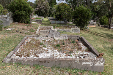
 Eltham District Historical Society Inc
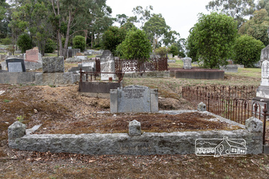
Photograph, Peter Pidgeon, Grave of George and Mary Knapman. Eltham Cemetery, Victoria, 5 April 2021
George Knapman was born c.1851 in Ashburton, Devon, England, the son of George Knapman and Elizabeth Grant nee Wyatt. George, his mother and three sisters arrived in the Port of Melbourne, 28 Jul 1857 aboard the ship, Mindoro from Plymouth, his father having preceded them some eighteen months earlier. George married Mary Jane Williams in 1877 and they settled in Eltham where they had five children; Percival George (1878), Florence Maud (1880), Laura Blanche (1882), Alfred Edgar (1886) and Gladys Victoria (1897). In 1879 George was elected a vestryman for St Margaret’s Church, a position he would be re-elected to for many years. Both he and Mary were active members of the church and social activities. In 1884 George was also engaged in collecting funds for the renovation of the St Helena church George was also a member of the Eltham Cricket Club. In May 1884 following completion of the cricket season, several players banded together to form a group holding fortnightly meetings for the purpose of giving readings, recitations, etc to relieve the dullness of the long winter evenings. Charles Wingrove was elected President, Rev. J.B. Gason Treasurer and George along with Messrs Evans, Bourke, D. McColl, C. Jarrold, George Hill and William Brown, members of the Committee. In 1885, George advertised two horses had strayed from his premises (reward £2) and in 1891 he had a cultivator for sale (price £7/10/-). In 1902 he was treasurer of the Eltham Rifle Club. His children attended Eltham Primary School. In 1904 he was a member of the school's Board of Advice and addressed children at an Arbor Day planting activity. In 1907 he was elected president of the Eltham Progressive League, calling for public toilets to be erected at a local picnic spot. George along with William John Taylor and Isaac Hill was also appointed a Trustee of the Eltham Rechabite Hall in Henry Street on behalf of the Hope of Eltham Tent No. 195 Victoria District Independent Order of Rechabites from December 1901 until its sale to the community in December 1921 for use as a public hall. George ‘Snowy’ Knapman was a blacksmith by trade. He owned and operated a shoeing forge and wheelwright workshop, known as Snowy Knapman’s Forge, in Main Road Eltham, next door to the Eltham Court House. The location was well chosen. Mail coaches from Melbourne passed through Eltham enroute to Christmas Hills and Yarra Glen, with another heading to Kingstown (now Panton Hill). It was common practice for horses to be changed at Eltham. Two photos taken June 4, 1907, captioned ‘Election Day Eltham’, show a large crowd of men assembled in Main Road outside Knapman's premises. They are waiting to vote at the Court House. There are no women in the crowd; they were not empowered to vote. George's brothers William and John were also blacksmiths at Heidelberg, continuing the business established by their father George, who had died in 1900. After William died in 1909, George moved to Heidelberg to take over from him. George died at his residence, ‘Devon’, Yarra Street, Heidelberg on March 16, 1923, and is buried in Eltham Cemetery with his wife Mary who died July 16, 1935, at Kew. Their former house at Eltham was located near where the WW1 Monument was erected in 1919, after they had moved to Heidelberg, at the corner of Bridge Street and Main Road and occupied by Mr. R. Trevena at the time of Mary’s death. Mary was sister to E.J. Williams, W. Williams and Mrs Fawkner, all residents of Eltham. In Loving Memory of George Knapman Died 15th March 1923 Also his wife Mary Jane Died 16th July 1935 Sadly Missed Born Digitaleltham cemetery, gravestones, george knapman, mary jane knapman (nee williams) -
 Eltham District Historical Society Inc
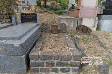
Photograph, Peter Pidgeon, Grave of William MacMahon Ball and Katrine S. Ball, Eltham Cemetery, Victoria, 5 April 2021
William MacMahon Ball (‘Mac’ Ball) was Professor of Political Science at Melbourne University from 1949 to 1968, having lectured there since 1923. He became known as an ABC commentator on international affairs from the early 1930s to the early 1960s. Between 1940 and 1944 he was Controller of Overseas Broadcasting (which later became Radio Australia). In 1945, he was political consultant to the Australian Delegation at the conference leading to the establishment of the United Nations, and in 1946 was the British Commonwealth Representative on the Allied Council during the post-war occupation of Japan. Mac and his wife Katrine (plus daughter Jenny) came to Eltham in 1942, and in 1945 moved into an old timber cottage at the eastern end of York Street. With help from Alistair Knox, Sonia Skipper, Gordon Ford and John Harcourt, the house was totally renovated to become an early example of Eltham mud-brick. Mac died in 1986 and is buried in Eltham Cemetery with Katrine. Part of their land backing onto Bridge Street was donated to Eltham Shire Council and is now a reserve called MacMahon Ball Paddock. In Loving Memory W. MacMahon Ball A.C. 29. 8. 1901 – 26. 12. 1986 Also Katrine S. Ball 1st Nov. 1899 to 29th Oct. 1991 Loved wife of Mac. Ball Mother of Jenny Grandmother of Bronwyn, David and Michael Much belovedBorn Digitaleltham cemetery, gravestones, katrine s. ball, william mcmahon ball -
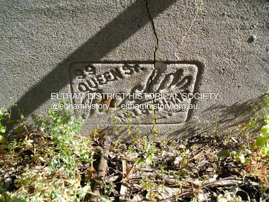
 Eltham District Historical Society Inc
Photograph, Peter Pidgeon, Grave of Richard George, Emily Ann (nee Davis) and Edith Jane Kaylock, Eltham Cemetery, Victoria, 5 April 2021
In his early adult life, Richard Kaylock worked as a whaler (visiting California and New Zealand) and later as a drover on a large cattle station in New South Wales. In 1848 he came to Melbourne, working as a slaughterman, then settled in Eltham in 1854, his occupation thereafter being variously recorded as butcher or orchardist. He also had some experiences at Ballarat during the Eureka Rebellion. He died in 1910 at the age of 84. His obituary described him as a "striking personality" who was "brusque to a fault" and "strictly upright, expecting others to be the same". It seems from his will that he was illiterate. He is buried in Eltham Cemetery with his wife Emily. His property was in Wellington Street (now Brougham Street) and apparently extended across the Diamond Creek. The land on the western side of the creek was farmed, the house being on the eastern side. For many years the Brougham Street bridge was generally known as "Kaylock's Bridge". It formed part of the original coach road to Eltham and in 1922 was described as an "old rustic bridge". Its low level and insubstantial construction made it susceptible to flood damage, necessitating frequent closures until repairs could be carried out. The original bridge was demolished in 1923 and replaced by a "new up-to-date" one. When a lack of finances delayed repairs to the Bridge Street bridge in 1931, traffic had to detour via Brougham Street for some time. Local residents feared that the Bridge Street bridge might never reopen. In Loving Memory Of Our Dear Father & Mother R.G. and E.A. Kaylock Also E.J. Kaylock Died 21st Jan. 1927 The Eternal God Is My PledgeBorn Digitaleltham cemetery, gravestones, brougham street bridge, edith jane kaylock, emily ann kaylock (nee davis), kaylocks bridge, richard george kaylock -
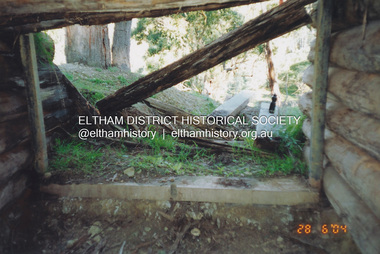 Eltham District Historical Society Inc
Photograph, Fay Bridge, Former Morrison property, Killeavey, Laughing Waters Road, Eltham, 28 June 2004
Beatrice Wanliss Irvine was the daughter of former Victorian Premier Sir William Irvine. From age 13 she lived at “Killeavey” off Laughing Waters Road (later accessed from Reynolds Road). In 1923 she married James Morrison and the couple received Killeavey as a wedding gift. The property supported fruit and vegetable growing as well as an impressive botanical garden. But James died in 1936 after a period of ill health, leaving Beatrice to support their six children. The Killeavey house was built atop a cliff, 40 metres above the Yarra River. The garden was designed in 1910 by William Guilfoyle who was the second director of the Royal Botanical Gardens. The house was totally destroyed in the Black Friday bushfires in 1939, but was rebuilt. Beatrice continued to live at Killeavey and became well regarded as a botanist and naturalist. She died in 1989 and is buried in Eltham Cemetery with her husband and one of their sons. The (rebuilt) house was demolished by Parks Victoria. It contains significant garden remnants. The surrounding bushland is valued for its significant plant communities.fay bridge collection, 2004-06-28, beatrice wanliss morrison (nee irvine), eltham, james morrison, killeavey, laughing waters road, william irvine -
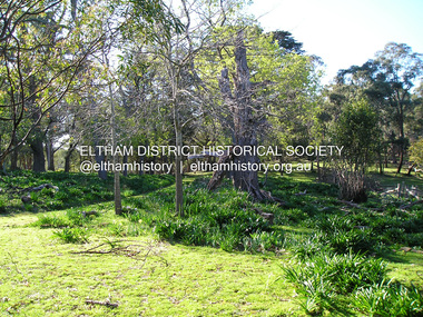 Eltham District Historical Society Inc
Photograph, Fay Bridge, Former Morrison property, Killeavey, Laughing Waters Road, Eltham, 30 August 2019
Beatrice Wanliss Irvine was the daughter of former Victorian Premier Sir William Irvine. From age 13 she lived at “Killeavey” off Laughing Waters Road (later accessed from Reynolds Road). In 1923 she married James Morrison and the couple received Killeavey as a wedding gift. The property supported fruit and vegetable growing as well as an impressive botanical garden. But James died in 1936 after a period of ill health, leaving Beatrice to support their six children. The Killeavey house was built atop a cliff, 40 metres above the Yarra River. The garden was designed in 1910 by William Guilfoyle who was the second director of the Royal Botanical Gardens. The house was totally destroyed in the Black Friday bushfires in 1939, but was rebuilt. Beatrice continued to live at Killeavey and became well regarded as a botanist and naturalist. She died in 1989 and is buried in Eltham Cemetery with her husband and one of their sons. The (rebuilt) house was demolished by Parks Victoria. It contains significant garden remnants. The surrounding bushland is valued for its significant plant communities.fay bridge collection, beatrice wanliss morrison (nee irvine), eltham, james morrison, killeavey, laughing waters road, william irvine, 2019-08-30 -
 Eltham District Historical Society Inc
Photograph, Fay Bridge, Former Morrison property, Killeavey, Laughing Waters Road, Eltham, 27 October 2019
Beatrice Wanliss Irvine was the daughter of former Victorian Premier Sir William Irvine. From age 13 she lived at “Killeavey” off Laughing Waters Road (later accessed from Reynolds Road). In 1923 she married James Morrison and the couple received Killeavey as a wedding gift. The property supported fruit and vegetable growing as well as an impressive botanical garden. But James died in 1936 after a period of ill health, leaving Beatrice to support their six children. The Killeavey house was built atop a cliff, 40 metres above the Yarra River. The garden was designed in 1910 by William Guilfoyle who was the second director of the Royal Botanical Gardens. The house was totally destroyed in the Black Friday bushfires in 1939, but was rebuilt. Beatrice continued to live at Killeavey and became well regarded as a botanist and naturalist. She died in 1989 and is buried in Eltham Cemetery with her husband and one of their sons. The (rebuilt) house was demolished by Parks Victoria. It contains significant garden remnants. The surrounding bushland is valued for its significant plant communities.fay bridge collection, beatrice wanliss morrison (nee irvine), eltham, james morrison, killeavey, laughing waters road, william irvine, 2019-10-27 -
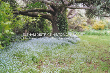 Eltham District Historical Society Inc
Photograph, Fay Bridge, New Zealand Oak at former Morrison property, Killeavey, Laughing Waters Road, Eltham, n.d
Beatrice Wanliss Irvine was the daughter of former Victorian Premier Sir William Irvine. From age 13 she lived at “Killeavey” off Laughing Waters Road (later accessed from Reynolds Road). In 1923 she married James Morrison and the couple received Killeavey as a wedding gift. The property supported fruit and vegetable growing as well as an impressive botanical garden. But James died in 1936 after a period of ill health, leaving Beatrice to support their six children. The Killeavey house was built atop a cliff, 40 metres above the Yarra River. The garden was designed in 1910 by William Guilfoyle who was the second director of the Royal Botanical Gardens. The house was totally destroyed in the Black Friday bushfires in 1939, but was rebuilt. Beatrice continued to live at Killeavey and became well regarded as a botanist and naturalist. She died in 1989 and is buried in Eltham Cemetery with her husband and one of their sons. The (rebuilt) house was demolished by Parks Victoria. It contains significant garden remnants. The surrounding bushland is valued for its significant plant communities.fay bridge collection, beatrice wanliss morrison (nee irvine), eltham, james morrison, killeavey, laughing waters road, william irvine, new zealand oak -
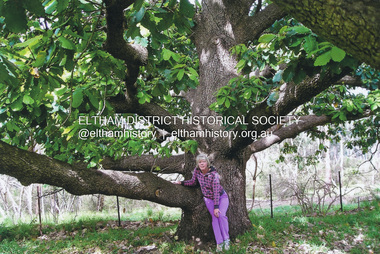 Eltham District Historical Society Inc
Photograph, Fay Bridge, Fay Bridge with New Zealand Oak at former Morrison property, Killeavey, Laughing Waters Road, Eltham, n.d
Beatrice Wanliss Irvine was the daughter of former Victorian Premier Sir William Irvine. From age 13 she lived at “Killeavey” off Laughing Waters Road (later accessed from Reynolds Road). In 1923 she married James Morrison and the couple received Killeavey as a wedding gift. The property supported fruit and vegetable growing as well as an impressive botanical garden. But James died in 1936 after a period of ill health, leaving Beatrice to support their six children. The Killeavey house was built atop a cliff, 40 metres above the Yarra River. The garden was designed in 1910 by William Guilfoyle who was the second director of the Royal Botanical Gardens. The house was totally destroyed in the Black Friday bushfires in 1939, but was rebuilt. Beatrice continued to live at Killeavey and became well regarded as a botanist and naturalist. She died in 1989 and is buried in Eltham Cemetery with her husband and one of their sons. The (rebuilt) house was demolished by Parks Victoria. It contains significant garden remnants. The surrounding bushland is valued for its significant plant communities.fay bridge collection, beatrice wanliss morrison (nee irvine), eltham, james morrison, killeavey, laughing waters road, william irvine, new zealand oak, fay bridge -
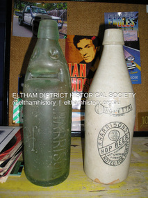 Eltham District Historical Society Inc
Photograph, Fay Bridge, Old bottles found at former Morrison property, Killeavey, Laughing Waters Road, Eltham, 2019
Lemonade, Non-alcoholic Hop Beer and milk bottlkes recovered from Killeavey give an insight into the types of drinks consumed by the Morrison family. Beatrice Wanliss Irvine was the daughter of former Victorian Premier Sir William Irvine. From age 13 she lived at “Killeavey” off Laughing Waters Road (later accessed from Reynolds Road). In 1923 she married James Morrison and the couple received Killeavey as a wedding gift. The property supported fruit and vegetable growing as well as an impressive botanical garden. But James died in 1936 after a period of ill health, leaving Beatrice to support their six children. The Killeavey house was built atop a cliff, 40 metres above the Yarra River. The garden was designed in 1910 by William Guilfoyle who was the second director of the Royal Botanical Gardens. The house was totally destroyed in the Black Friday bushfires in 1939, but was rebuilt. Beatrice continued to live at Killeavey and became well regarded as a botanist and naturalist. She died in 1989 and is buried in Eltham Cemetery with her husband and one of their sons. The (rebuilt) house was demolished by Parks Victoria. It contains significant garden remnants. The surrounding bushland is valued for its significant plant communities.fay bridge collection, beatrice wanliss morrison (nee irvine), eltham, james morrison, killeavey, laughing waters road, william irvine, bennett lemonade, bottles, milk bottle, o'neill bros north fitzroy, r. harrison, r. harrisons hop beer -
 Eltham District Historical Society Inc
Photograph, Fay Bridge, The Tree Project, 2009
... . It stands in the township of Strathewen, Victoria, Australia ...Australia's worst natural disaster, fed by extreme temperatures, tornado-like wind speeds and tinder-dry land, culminated in the disaster we now know as Black Saturday, February 7, 2009. Before the sun would set on the blackest day in Australia's history, thousands of hectares would become blackened landscape and an unparalleled loss of lives could only mean that many areas would never be the same again. To remember the people lost to the devastating Black Saturday fires of 2009 and our brave CFA men and women who battled the elements to protect our towns, the Australian Blacksmiths Association (Victoria) Inc. invited blacksmiths from across the country and around the world to contribute to the creation of a steel gumtree. The Blacksmiths' Tree, as it came to be called, was erected on February 14, 2014. Five years in the making, this 10m high stainless steel and copper tree was forged with love and care by hundreds of blacksmiths across 20 countries. It stands in the township of Strathewen, Victoria, Australia to remember all of those who perished in the Black Saturday fires of 2009, those who fought the fires and those who continue to live their lives with hope and courage. The tree stands at the Peter Avola Memorial Pavilion, 160 Chadds Creek Road, Strathewen, Victoria.fay bridge collection, black saturday, kinglake, victorian bushfires - 2009, the tree project