Showing 635 items
matching w form
-
 Halls Gap & Grampians Historical Society
Photograph - B/W, 1866
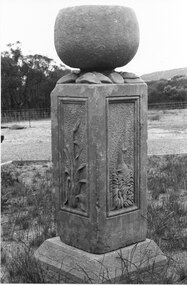
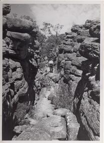
Watkins created his sculpture for an exhibition in Melbourne 1866: "I dressed the pillar about 2 foot 6 inches high and 16 inches square and proceeded to carve in each panel representation characteristic of Victoria 1st Panel a Kangaroo in a small scrub thicket, 2nd an Emu amongst a clump of little flowering correa; 3rd the Wimmera Down and on the 4th side my name and the date AD 1866 On the top of the pillar was an urn of globular form to represent the seed pod of the Eucalypti with spreading leaves underneath" Extract taken from 'Victoria's Wonderland' a Grampians history Monument now in private handsHeatherlie Quarry; Obelisk : Photo shows stone monument created by Francis Watkins using materials from quarry Photo shows two sided view of monument with large stone on topquarrying, mt difficult quarry -
 Halls Gap & Grampians Historical Society
Photograph - B/W
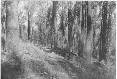
The Jinker tracks were vitally important during the early years of European settlement The first routes were known as bridle pathsPhoto shows track through bush track better formed than othersBridle track written on backaccess routes, jinker track -
 Halls Gap & Grampians Historical Society
Photograph - B/W, C 1920s
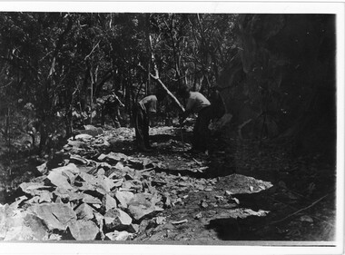
Men have started to form the Mt Victory Road. Until the 1900's access to the Stoney Creek gorge was via a winding bridal jinker track. Increased traffic lead to much of this route being widened into what became known as Bluff Road. Within a few years the route was further improved and was officially named Mount Victory Road in 1930.Photo shows 3 men working with pick and shovel on roadPick and shovel Mt Victory Rdaccess routes, roads, access routes, road building -
 Halls Gap & Grampians Historical Society
Photograph - B/W
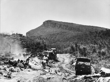
Photo shows men & machinery forming the road up Mt William. There are 8 men, 1 bull-dozer, 1 jeepaccess routes, roads, access routes, mt william road -
 Halls Gap & Grampians Historical Society
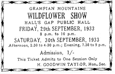
Document - Ticket (B/W), C 1933
Annual wildflower shows took over the Hall's Gap Hall during spring and, in the 1930's, transformed it into a veritable wonderland. So popular were these displays that they have continued through until present times, the format has altered but the display of flowers remains the same. Ladies' Committees were formed to sell art and crafts during shows, and much of the revenue from these events went towards a future new building. The ticket shows that the admission price in 1933 was 1/- (one shilling). A comparison with Record 387 shows that the price had not risen from that rate in 1938. The Hon. Sec at this time was H. Goodwin Taylor.A ticket for the Grampians Mountains Wildflower Show to be held in Halls Gap Public Hall on 29/09/1933 and 30/09/1933.media, tickets, events, wildflower show -
 Halls Gap & Grampians Historical Society
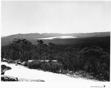
Photograph - B/W, C 1960s (?)
This photo is a view from the road at Reed's Lookout.The photo shows the view from beside a road (the road at Reed's Lookout), across bushland to a large reservoir (Lake Wartook). There is a range of peaks in the background. The road forms the foreground.'Forests Commission, Victoria' inscribed on bottom, right of border. 'Publicity & Public relations Branch, When reproducing please Acknowledge Forests Commission, Victoria, Negative No. 322-34' stamped on back.scenery, lookouts -
 Halls Gap & Grampians Historical Society
Photograph - B/W
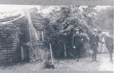
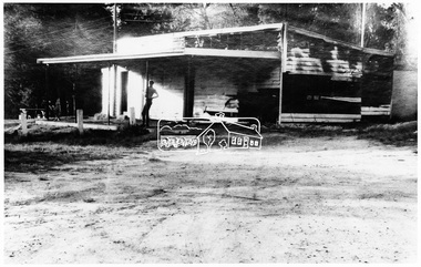
Frederick Paasch 's house with two Chandlers outside. See Victoria's Wonderland p98-99. Weather board slab building with climbing rose growing on side of house. Bricks form base of chimney with an iron flue forming rest of chimney. Two men and a horse stand to the right of the cottage.buildings, houses -
 Halls Gap & Grampians Historical Society
Photograph - B/W, C 1960s (?)
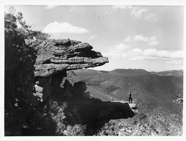
The photo is of "The Balconies" overlooking the back of the Wonderland Range. The photo of typical of those taken by the Forestry Commission at that time.Photo shows a woman standing on a rocky platform which protrudes out over a well-treed valley. Another rock almost forms a canopy overhead. Part of the rock on which the woman is standing on is in shade, she is in the full sun."No. 5" written in pencil on the back.scenery, lookouts -
 Halls Gap & Grampians Historical Society
Photograph - B/W, C 1960s
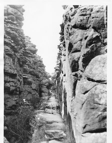
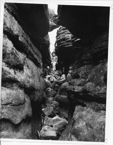
Photo is of area known as ' Silent Street'. It is on path to Pinnacle Lookout.Photo shows a man walking along slabs of rock that form a path between rocky outcrops. He is walking away from the camera. Various shrubs line the path. Gum trees can be seen in background.'Copyright photograph'. This photograph may be reproduced on condition that it is acknowledged as 'Victorian Railways Photograph', p3456- Silent Street . Halls Gap.scenery, wonderland range -
 Halls Gap & Grampians Historical Society
Photograph - B/W, C 1960s
This part of the walking track is known as "Silent Street' and forms part of the Wonderland /Pinnacle track. the photo is typical of those produced by Victorian Railways for tourism.Photo shows walking track through rocky gorge. A step ladder and railings can be seen. A man is walking up the track.scenery, wonderland range -
 Halls Gap & Grampians Historical Society
Photograph - B/W, C 1960s
Area in photo is known as the Grand Canyon and forms part of the Wonderland /Pinnacle walk. This photo is typical of those taken by the Victorian Railways for tourism.Photo shows 2 women and a child seated on rocks and looking up at camera. they are the middle of a large rocky canyon. An iron ladder and railing can be seen through bushland in background.scenery, wonderland range -
 Halls Gap & Grampians Historical Society
Photograph - B/W, C 1930s
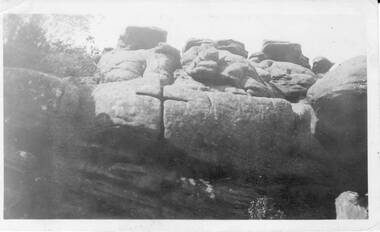
Image is known as 'The Cross' and was in the area of 'Silent Street',part of the walk to the Pinnacle.Photo shows an outcrop of rocks with a 'cross' which has been formed in the rocks.'The Cross in Silent Street, Wonderland.scenery, wonderland range -
 Halls Gap & Grampians Historical Society
Photograph - B/W, 14/04/1931
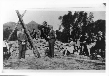
The photo shows the opening ceremony of Henham Township by Lord Stradbroke (the man on the right of the structure). A strip of land 2 kilometres long and half a kilometre wide had been approved as suitable for subdivision into 591 quarter acre blocks valued at 30-35 pounds each. Unfortunately it turned out to be a "fizzer". For further information see Victoria's Wonderland pp 93-95, 103.Photo shows a group of people sitting on and standing behind a low pile of rocks that sweeps around a wooden structure, which is three rough logs standing and lashed together to form a rough pyramid. A pulley is attached to the apex of the pyramid and a large stone block is suspended from it. Two men stand, one in front of and one beside the structure, both wear suits and are holding pieces of paper. A young boy sits in the left foreground in front of one of the poles.events, ceremonies -
 Halls Gap & Grampians Historical Society
Photograph - B/W
the three women appear to be in 'Silent Street', part of the Wonderland Range on the pathway to The Pinnacle lookout.3 young women sitting and standing amongst 2 rock cliffs with tumbled rocks that appear to form steps. a railing can be seen behind standing girl. Clothing is suggestive of the 1970s period.scenery, wonderland range -
 Eltham District Historical Society Inc
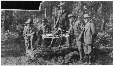
Photograph, Members of the Committee of Management of the Kinglake National Park who spent the week-end inspecting the improvements in this beautiful forest reserve
L-R: Prof. J. Neill Greenwood, Messrs. H. Hewitt and A.B. Blair (Sec.), Prof. W.A. Laver (Chairman) and Mr. W. Thorn. Source: Dr. Edith J. Hewitt from The Argus, 11 Jan 1930This photo forms part of a collection of photographs gathered by the Shire of Eltham for their centenary project book,"Pioneers and Painters: 100 years of the Shire of Eltham" by Alan Marshall (1971). The collection of over 500 images is held in partnership between Eltham District Historical Society and Yarra Plenty Regional Library (Eltham Library) and is now formally known as the 'The Shire of Eltham Pioneers Photograph Collection.' It is significant in being the first community sourced collection representing the places and people of the Shire's first one hundred years.Digital imagesepp, shire of eltham pioneers photograph collection, kinglake, committee of management, a.b. blair, h. hewitt, kinglake national park, prof. j. neil greenwood, prof. w.a. laver, w. thorn -
 Eltham District Historical Society Inc
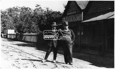
Photograph, Queenstown; St. Andrews Hotel
Source: Mrs. W. Moss (nee Nink), Box 20, MonbulkThis photo forms part of a collection of photographs gathered by the Shire of Eltham for their centenary project book,"Pioneers and Painters: 100 years of the Shire of Eltham" by Alan Marshall (1971). The collection of over 500 images is held in partnership between Eltham District Historical Society and Yarra Plenty Regional Library (Eltham Library) and is now formally known as the 'The Shire of Eltham Pioneers Photograph Collection.' It is significant in being the first community sourced collection representing the places and people of the Shire's first one hundred years.Digital imagesepp, shire of eltham pioneers photograph collection, queenstown, st andrews, st andrews hotel -
 Eltham District Historical Society Inc
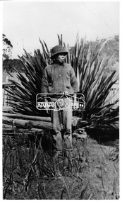
Photograph, Queenstown - St. Andrews District. Ah Yet of Queenstown
Source: Mrs. W. Moss (nee Nink), Box 20, MonbulkThis photo forms part of a collection of photographs gathered by the Shire of Eltham for their centenary project book,"Pioneers and Painters: 100 years of the Shire of Eltham" by Alan Marshall (1971). The collection of over 500 images is held in partnership between Eltham District Historical Society and Yarra Plenty Regional Library (Eltham Library) and is now formally known as the 'The Shire of Eltham Pioneers Photograph Collection.' It is significant in being the first community sourced collection representing the places and people of the Shire's first one hundred years.Digital imagesepp, shire of eltham pioneers photograph collection, queenstown, st andrews, ah yet, gold miners -
 Eltham District Historical Society Inc
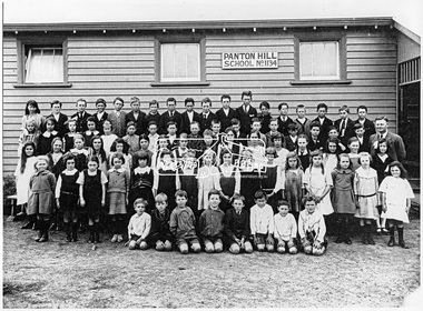
Photograph, Panton Hill School, 1924
Source: Mr. Frank Smith, "Kia-Ora", Panton Hill Also a separate list of names PANTON HILL SCHOOL 1924 (SEPP_0244) Two hand written lists of names with some conflicting information L-R Back Row: Eily O’Day, R. Foubister, E. Moore, H. Purcell, F. Peake, C. Williams, H. Hewitt, J. Coutie, D. Cracknell, F. Smith, J. Smith, A. Purcell, Bob O’Day, C. Colvin, Belfield?, K. Smith, R. Gardiner, Colin Rogers Second Row: ?, Lorraine Smith, Phyllis Howard, Jean Cracknell, Edna Williams, Ces Tosch, Charlie Peake, Les Smith, Reg Hargreaves, Ken Canty, ?, Keith Smith, ?, B. Cracknell, Ron Smith, Guy Mills (Greford), Sefton Howard, Mr. Gardiner (Head Teacher) Third Row: E. Mosely, Phillis Saville, Floss Tosch, M. Milson, Essie Howard, Ethel Smith, Jessie Sinclair, Edna Woodman, Una Saville, Ida Kennedy, Dorothy Smith, Rene Keele, Margaret Powell, L. Mosely, Una Williams, Rene Purcell Fourth Row: Hazel Mills, Gladys Stone, Ruby O’Day, Stella Tosch, Joyce Smith, Peg Powell, Ailsa Gardiner, Milly Adams, Phil Groube, M. Carter, W. Stone, D. Milsom?, D. Mills, Roma Howard, Marg Howard Front Row: Donaldson?, Doug Smith?, Len Smith?, Podge Cracknell, G Carter, A. Glennon, ?,? Alternate list L-R Back Row: Eillen O’Day, R. Foubister, Eric Moore, H. Purcell, F. Peake, C. Williams, H. Hewitt, J. Coutie, Don Cracknell, F. Smith, J. Smith, H. Purcell, B. O’Day, C. Colvin, J. Belfield, K. Smith, R. Gardiner, C. Rogers Second Row: M. Millisom, L. Smith, M. Moon, J. Cracknell, U. Williams, C. Tosch, C. Peake, L. Smith, R. Hargreaves, G. Carter, H. Stone, K. Smith, B. Moon, L. Cracknell, R. Smith, G. Mills, S. Howard, Mr. Gardiner (Head Teacher) Third Row: E. Moseley, P. Saville, F. Tosch, M. Millisom, E. Howard, E. Smith, J. Sinclair, E. Woodman, U. Saville, I. Kennedy, D. Smith, R. Keele, M. Powell, L. Mosely, E. Williams, R. Purcell First Row: H. Mills, W. Stone, R. O’Day, S. Tosch, J. Smith, P. Powell, A. Gardiner, M. Adams, P. Groube, M. Carter, G. Stone, J. Millisom, D. Millisom, D. Mills, R. Howard, M. Howard Front Row: Maisch, D. Smith, A. Belfield, L. Smith, A. Howard, A. Moseley, A. Glennon, D. Millisom This photo forms part of a collection of photographs gathered by the Shire of Eltham for their centenary project book,"Pioneers and Painters: 100 years of the Shire of Eltham" by Alan Marshall (1971). The collection of over 500 images is held in partnership between Eltham District Historical Society and Yarra Plenty Regional Library (Eltham Library) and is now formally known as the 'The Shire of Eltham Pioneers Photograph Collection.' It is significant in being the first community sourced collection representing the places and people of the Shire's first one hundred years.Digital imagesepp, shire of eltham pioneers photograph collection, panton hill, panton hill state school, state school -
 Eltham District Historical Society Inc
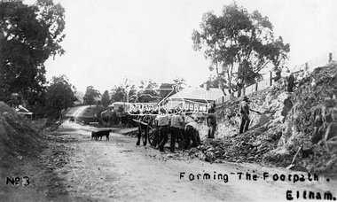
Photograph, Tom Prior, Forming the footpath, Eltham, c.1906
... construction York Street Digital image (4 x 4 inch B&W neg copy missing ...Photo: Tom Prior (brother of Mrs Ernest Richard Reynolds) using his home-made camera. Shows Richard Reynolds' cart and horses (Old Mac and Punch) and the Reynolds' dog. Gahan house on left. Bakery on right at corner of York Street. This image was used in August 1971 issue of Australian Municipal JournalThis photo forms part of a collection of photographs gathered by the Shire of Eltham for their centenary project book,"Pioneers and Painters: 100 years of the Shire of Eltham" by Alan Marshall (1971). The collection of over 500 images is held in partnership between Eltham District Historical Society and Yarra Plenty Regional Library (Eltham Library) and is now formally known as the 'The Shire of Eltham Pioneers Photograph Collection.' It is significant in being the first community sourced collection representing the places and people of the Shire's first one hundred years. The Reynolds family were early settlers in Research. The Reynolds/ Prior collection of photographs were taken by Tom Prior, the maternal uncle of Ivy Reynolds, around 1900 and the 60 photos in the album give a fine overview of many of the landmarks of Research and Eltham over 100 years ago. lvy lived in the family home for many years at 106 Thompson Cres Research. Ivy's father, Ernst Richard Reynolds and grandfather, Richard Reynolds, lived at the same address. Ivy's father Richard worked for Mr. Trail on his property in Research. Reynolds Road is named after the family. Mr Tom Prior (wife Eva) worked at the Melbourne zoo. He was very innovative and made his own camera, using the black cloth hood to exclude the light. The photographs are a reminder of the rural nature of Research and Eltham and its rich heritage.Digital image (4 x 4 inch B&W neg copy missing)shire of eltham pioneers photograph collection, eltham, main road, australian municipal journal august 1971, dudley street, gahan house, maria street, old mac (horse), punch (horse), reynolds prior collection, richard reynolds, road construction, york street -
 Eltham District Historical Society Inc
Negative - Photograph, George W. Bell, Excavation of site for new Eltham Shire Office building, 895 Main Road, Eltham, 1964
Black and white photograph of bulldozer excavating the former Shillinglaw Cottage site for new Shire Offices. 'Shillinglaw Trees' in background. The cottage and land were purchased by the Shire of Eltham as the site for a new shire office building. The cottage was destined for demolition but members of the community concerned at losing one of the areas earliest buildings (built c.1859) initiated a fund-raising campaign to save the cottage. In 1964 the cottage was dis-assembled, all the bricks numbered and reassembled several hundred meters to the south on a site between the Gahan house and the Eltham Railway Trestle Bridge (present-day Panther Place), which became known as the Eltham Common. The new shire offices at 895 Main Road were opened in 1965. Following the Kennett Government amalgamation of local government areas in 1994, the Shire of Eltham ceased to exist, and a new Shire of Nillumbik was created 15 December 1994 from the former Eltham shire and parts of the Diamond Valley shire. The former West Riding which included parts of Montmorency, Lower Plenty and Briar Hill were ceded to the new City of Banyule. Commissioners were appointed for several years and the new Council occupied the former offices of the Shire of Diamond Valley in Greensborough. The former Eltham Shire offices remained vacant until August 1996 the Commissioners suddenly elected to have the former Shire offices demolished immediately and the site has remained vacant ever since. It was not until 1997 before the community was allowed to democratically elect new Councillors to represent them. This photo forms part of a collection of photographs gathered by the Shire of Eltham for their centenary project book,"Pioneers and Painters: 100 years of the Shire of Eltham" by Alan Marshall (1971). The collection of over 500 images is held in partnership between Eltham District Historical Society and Yarra Plenty Regional Library (Eltham Library) and is now formally known as the 'The Shire of Eltham Pioneers Photograph Collection.' It is significant in being the first community sourced collection representing the places and people of the Shire's first one hundred years.Digital image 4 x 5 inch B&W Negeltham, eltham shire office, excavation, george w. bell collection, main road, municipal offices, shillinglaw cottage, shillinglaw trees, shire of eltham pioneers photograph collection, shire offices, significant tree -
 Eltham District Historical Society Inc
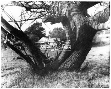
Negative - Photograph, George W. Bell, Gahan house, Main Road, Eltham, c.1964
View of Gahan house originally known as 'Derril' framed by an old tree. Part of a collection of photos donated by George W. Bell to the former Shire of Eltham, c.1970. In 1964 the Shire of Eltham acquired the land upon which Shillinglaw Cottage stood for the purposes of building a new Shire Office. Shillinglaw Cottage was to be demolished but a campaign was managed by the local community to save Shillinglaw Cottage which was relocated to its present day site, (Panther Place, Eltham) immediately in front of the Gahan house as viewed in the photo. The Gahan house was subsequently demolished.This photo forms part of a collection of photographs gathered by the Shire of Eltham for their centenary project book, "Pioneers and Painters: 100 years of the Shire of Eltham" by Alan Marshall (1971). The collection of over 500 images is held in partnership between Eltham District Historical Society and Yarra Plenty Regional Library (Eltham Library) and is now formally known as 'The Shire of Eltham Pioneers Photograph Collection.' It is significant in being the first community sourced collection representing the places and people of the Shire's first one hundred years.Digital image 4 x 5 inch B&W Negsepp, shire of eltham pioneers photograph collection, eltham, shillinglaw cottage, gahan, gahan house, george w. bell collection, houses, main road, panther place, significant tree -
 Eltham District Historical Society Inc
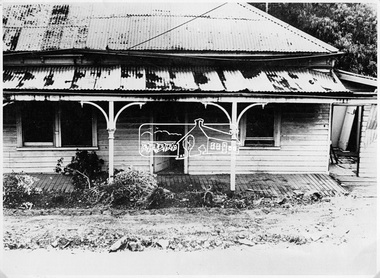
Negative - Photograph, Eltham - Gahan's House (now demolished)
Source: Geo. W. Bell, ElthamShillinglaw Cottage is itself historically, aesthetically and socially significant to the Shire of Nillumbik and is registered on the Victorian Heritage Database. This photo forms part of a collection of photographs gathered by the Shire of Eltham for their centenary project book, "Pioneers and Painters: 100 years of the Shire of Eltham" by Alan Marshall (1971). The collection of over 500 images is held in partnership between Eltham District Historical Society and Yarra Plenty Regional Library (Eltham Library) and is now formally known as 'The Shire of Eltham Pioneers Photograph Collection.' It is significant in being the first community sourced collection representing the places and people of the Shire's first one hundred years.Digital image 4 x 5 inch B&W Negsepp, shire of eltham pioneers photograph collection, eltham, shillinglaw cottage, gahan house -
 Eltham District Historical Society Inc
Negative - Photograph, Eltham - Burnt out football pavilion. Eltham Central Park
Source: Geo. W. Bell, ElthamThis photo forms part of a collection of photographs gathered by the Shire of Eltham for their centenary project book,"Pioneers and Painters: 100 years of the Shire of Eltham" by Alan Marshall (1971). The collection of over 500 images is held in partnership between Eltham District Historical Society and Yarra Plenty Regional Library (Eltham Library) and is now formally known as the 'The Shire of Eltham Pioneers Photograph Collection.' It is significant in being the first community sourced collection representing the places and people of the Shire's first one hundred years.Digital image 4 x 5 inch B&W Negsepp, shire of eltham pioneers photograph collection, eltham, eltham central park, football pavillion -
 Kiewa Valley Historical Society
Pat Butter Profiler, Circa 1950s
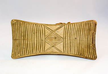
This butter pat profiler may have been manufactured post 1967(year post codes appeared in Australia) however the post code was only stamped on after it was machined. This type of butter mould was used by rural families to fashion home/farm made butter. This period was in most rural regions a time of self sufficiency where any domestic type implement which could be fashioned by the family would be crafted with skill. Shopping for goods required catalogues from stores located in major rural towns and cities and involved lengthy waiting times. Travelling to and from these specialised stores was not pleasant due to the relatively poor quality of the roads and the lengthy times taken. The small general stores in the Kiewa Valley could not cater for all the needs of the valley. The 1960's was a time when facilities especially goods and services started to improve drastically. The S.E.C. of Victoria with its Kiewa Hydro Electricity Scheme provided not only an improvement of facilities in the valley but also a increase in the population. This increase resulted in a greater demand for local produce.This item is one of many domestic food processing implements used by Kiewa Valley households in the mid 1900s, whether on the farm or in the small towns and hamlets. Self sufficiency was the key to survival during these early times. Where ever possible supplies from within the valley were preferred to that brought in by travelling salesmen or traders. This butter mould and butter pat was commonly used to fashion "home" made butter throughout the valley and in some cases supplied to "outside" regional towns. Although this method of production was phased out by better access to goods from nearby cities the revival of the good organic home grown produce in the 1980s saw a greater demand of this type of farm based produce.This butter Pat/Profiler has on its base two patterns. On each end it has horizontal grooves cut into the wood which produce distinct lines onto the surface of the butter. between these grooves there is a section of two double lines crossing in the middle and separated by eleven horizontal lines The base has an elongated rectangular shape. The upper body has been sanded into a smooth convex shaped form where a wooden circular hand grip has been fashioned.On the top of the hand grip is stamped in black print"T. & W. Davies" and under this"TAWONGA 3697"domestic food preparation, wooden butter pat, butter mould circular, dairy industry -
 4th/19th Prince of Wales's Light Horse Regiment Unit History Room
Instrument - Trumpet, Cavalry, Couesnon Cie, 1901 (exact)
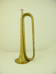
The 2nd Light Horse Regiment was raised at Enoggera in Queensland on 18 August 1914. Its recruits came mainly from Queensland but some hailed from the northern rivers district of New South Wales. The 2nd was one of three regiments of the 1st Light Horse Brigade – the first Australian mounted formation raised by Australia during the First World War. The regiment sailed from Brisbane on 25 September and disembarked in Egypt on 9 December. The 2nd Light Horse Regiment deployed to Gallipoli without its horses and landed there on 12 May 1915, joining the New Zealand and Australian Division. It played a defensive role for most of the campaign but did attack the Turkish trenches opposite Quinn’s Post, one of the most contested positions along the ANZAC Line. The first assault wave was mown down and fortunately the officer commanding the attack had the wisdom and courage to call it off. The 2nd was withdrawn from the front line in September and left the peninsula on 18 December. Back in Egypt, the 2nd Light Horse joined the ANZAC Mounted Division. Between January and May 1916, the regiment was deployed to protect the Nile valley from bands of pro-Turkish Senussi Arabs. On 18 May, as part of its parent brigade, it joined the forces defending the Suez Canal. The 1st Light Horse Brigade played a significant role in turning back the Turkish advance on the canal at the battle of Romani on 4 August. In ensuing days the regiments of the brigade participated in the immediate follow-up of the defeated Turks, but were soon withdrawn to rest. The 2nd Light Horse Regiment rejoined the Allied advance across the Sinai in November and was subsequently involved in the fighting to secure the Turkish outposts on the Palestine frontier – Maghdaba on 23 December 1916 and Rafa on 9 January 1917. A stint of protective duty along the line of communications through the Sinai followed. The 2nd’s next major engagement was the abortive second battle of Gaza on 19 April. Gaza finally fell on 7 November, after a wide outflanking move via Beersheba, in which the 1st Light Horse Brigade played a part. With the capture of Gaza, the Turkish position in southern Palestine collapsed. The 2nd Light Horse Regiment participated in the advance to Jaffa that followed, and was then committed to operations to clear and occupy the west bank of the Jordan River. It was involved in the Amman (24–27 February) and Es Salt (30 April–4 May) raids and the repulse of a major German and Turkish attack on 14 July 1918. The final British offensive of the campaign was launched along the Mediterranean coast on 19 September 1918, with the ANZAC Mounted Division taking part in a subsidiary effort east of the Jordan aimed at Amman. Turkey surrendered on 30 October 1918. The 2nd Light Horse Regiment sailed for Australia on 13 March 1919 without their horses, which were either shot or transferred to Indian cavalry units. Events in the daily routine of the soldier were signalled by bugle and trumpet calls. This trumpet is signicant because historically, it was issued to the 2nd Australian Light Horse Regiment in 1912. This Regiment served with distinction in Gallipoli and Palestine in World War 1. It is probable, but not confirmed, that tthe trumpet was used by the Regiment during these operations. Each light horse regiment was divided into four squadrons. Each squadron had a trumpeter sergeant, equipped with a cavalry trumpet, who was employed at the Squadron Headquarters Technically called a cavalry trumpet, this brass instrument can be described as a "simple trumpet" ie. the direct forerunner of the modern valve trumpet. It is in E flat not B flat as is the bugle. Both were carried slung over the player's body by means of green tasselled cords.Crest with inscription: "Exposition Universelle De Paris" with circular logo with inscribed "1900". "Hors Concours Membre De Jury". Logo formed of initials (not deciphered). "Couesnon Cie 94 Rue Dangouleme Paris". Bomb burst type logo with "01" in centre. "W H Paling & Co Ltd Sydney NSW Brisbane" On bell: "Mounted Rifles (2nd ALH)" trumpet, cavalry, musical instrument, 2nd light horse, mounted rifles -
 4th/19th Prince of Wales's Light Horse Regiment Unit History Room
Photo, Light Horse Parading at Race Course
Photo is believed to be of the 3rd Light Horse Regiment parading at Morphetville Race Course, South Australia prior to embarking for service in World War 1B&W photo of an Australian Light Horse Regiment formed up on a race course. Includes support wagons and a Furphy water cart. Mounted on cardboard backing.Not any3rd light horse, photo -
 Kiewa Valley Historical Society
Sign - C.W.A. - Country Women's Association
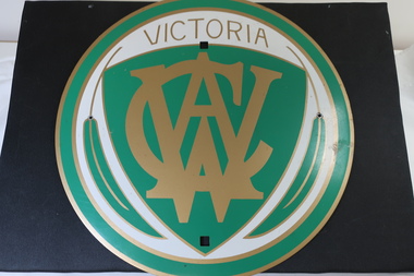
C.W.A. is the Country Women's Association of Victoria and was formed in 1928. It is a self funded philanthropic organisation. It is non-sectarian, non-party-political, non profit lobby group working predominantly in the interests of women and children in rural areas. It helps in the provision of services to its members and the improvement of amenities in rural areas.The C. W. A. has had branches in the Kiewa Valley up until the present day.Round metal sign. On the front it is green, white and gold. There are four holes in it for attaching it to a fixture eg. Entry to town sign.c.w.a., country women's association -
 Warrnambool and District Historical Society Inc.
Document Warrnambool Woollen Mill, Loose sheets Production analysis 1937-1938, 1937
In 1869, the Warrnambool Meat Preserving Company commenced their business on the site, where it operated until 1875 when it was sold to the directors of the Warrnambool Woolen Mill Company. After being destroyed by fire in 1882 it wasn’t until 1910 that the Warrnambool Chamber of Commerce was approached by Marcus Saltau and Peter McGennan to invest in a new mill. The original directors were James Dickson, P J McGennan, Robert Swinton, M Saltau, and J W Younger. In 1955 the Warrnambool Woollen Mill formed a partnership with the Wangaratta Woollen Mills. Dunlop bought the mill in 1968. From that time until its closure in 2000 it had a number of different owners, the last being the Smith Family Industries. These sheets provide data relating to sales of various different blankets in colours and sizes and where sales occurred . All the capital cities are listed with quantities and customer numbersThe woollen mill was one of the major industries of Warrnambool for nearly100 years. This document is one of many in the collection of the Warrnambool and district historical society which gives an insight into the scale and type of production during the 20th century.Rectangular bundle of loose pages with card on either side and held together with string. Pages are lined and typed with data and also have two small holes and one elongated hole stamped between the smaller ones.Analysis Season 1937-1938 written in red pencil on front card. 'These sheets stocked in 25 patterns by peacock Bros Pty Ltd Melbourne Sydney Adelaide Perth and Brisbane. When ordering this pattern specify No D5' printed on each of the paper sheets.warrnambool, warrnambool woollen mill, woolen mill, dunlop olympic, marcus saltau p j mcgennan james dickson, robert swinton j w younger, wangaratta, dreamspun -
 Warrnambool and District Historical Society Inc.
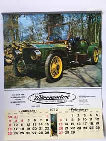
Calendar, Warrnambool Woollen Mill 1972, 1971
In 1869, the Warrnambool Meat Preserving Company commenced their business on the site, where it operated until 1875 when it was sold to the directors of the Warrnambool Woolen Mill Company. After being destroyed by fire in 1882 it wasn’t until 1910 that the Warrnambool Chamber of Commerce was approached by Marcus Saltau and Peter McGennan to invest in a new mill. The original directors were James Dickson, P J McGennan, Robert Swinton, M Saltau, and J W Younger. In 1955 the Warrnambool Woollen Mill formed a partnership with the Wangaratta Woollen Mills. Dunlop bought the mill in 1968. From that time until its closure in 2000 it had a number of different owners, the last being the Smith Family Industries. this calendar is an advertising item associated with the Woollen Mill.A common item associated with a long running Warrnambool business.Large 6 page calendar for 1972 with coloured photographs of vintage cars.with Warrnambool Woollen Mill logo underneath with months [printed in black on yellow at the bottom of each page. Metal strip at top.Printed in New Zealand by tanner Couch Ltdwarrnambool,, warrnambool woollen mill 1972 -
 Warrnambool and District Historical Society Inc.
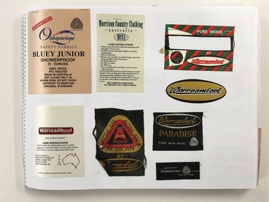
Booklet, Scrap Book Warrnambool Woollen Mill, Late 20th century
In 1869, the Warrnambool Meat Preserving Company commenced their business on the site, where it operated until 1875 when it was sold to the directors of the Warrnambool Woolen Mill Company. After being destroyed by fire in 1882 it wasn’t until 1910 that the Warrnambool Chamber of Commerce was approached by Marcus Saltau and Peter McGennan to invest in a new mill. The original directors were James Dickson, P J McGennan, Robert Swinton, M Saltau, and J W Younger. In 1955 the Warrnambool Woollen Mill formed a partnership with the Wangaratta Woollen Mills. Dunlop bought the mill in 1968. From that time until its closure in 2000 it had a number of different owners, the last being the Smith Family Industries.This book contains a large number of labels some of which would have been sewn to the corner of the many blankets which were manufactured over the long history of the Woollen Mill.Some are cloth of a satin type. Some state care instructions and some have been made under other name brands such as Myer, Patersons and Nile. There is also a range of types of blankets such as travel and picnic rugs, baby blankets.Some are pure wool, others are a blend of synthetic and wool, mohair. In the latter stages of its operation, under the ownership of the Smith family , recycled woollen product was produced.This is an interesting collection of labels which were produced and collected over a long period of time and therefore provide a valuable insight into different styles and variety of the blankets produced by the Warrnambool Woollen mill which played a large part in the social and employment history of the city for nearly all of the 20th century. The different styles and colours provide a snapshot of design and artistic styles of the period. Large Spirax folder with yellow and white check patterned cover with dark blue writing.A Warrnambool label in gold,black and white is glued to front cover . Back cover is grey heavier card. The white pages have a large number of labels which relate to the Warrnambool Woollen Mill . Some are stapled and others are glued.Genuine drawing cartridge 48 sheets . Made in Indonesia.warrnambool, warrnambool woollenmill,warrnambool blankets warrnambool blankets labels,