Showing 429 items matching "whittlesea"
-
 City of Whittlesea
Badge - Badges - Advocacy Campaign, Access Denied, 2014
Access Denied was a joint advocacy campaign between the City of Whittlesea and the local community in the lead up to the 2014 Victorian State Election. The campaign called on all political parties to commit to extending the railway line from South Morang to Mernda and building access ramps on the Hume Freeway at O’Herns Road in Epping North. The campaign was a success and secured almost $650 million in promises from the incoming Labor Government to build these projects. Badge, metal back with pin, white plastic printed front, black and red textConnect O'Herns Road / Access Denied / Get on Board / www.accessdenied.net.au / Build Mernda Railbadges, campaign badges, south morang railway, mernda railway -
 City of Whittlesea
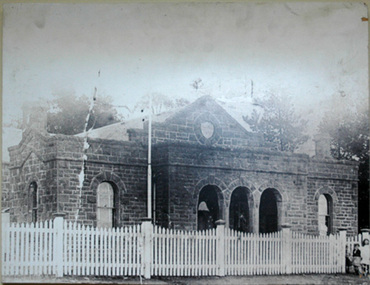
Photograph (item) - Photographs - Buildings, Epping Shire Hall
Image - Epping Shire Hall, c 1905 (F Coote) The Shire Hall was erected by Thomas Mitchell in 1871, at a cost of 628 Pounds. It served as council chambers and offices, courthouse, public meeting room and dance hall. (Wuchatsch & Hawke, 1988/1985). Part of Epping Civic Precinct Heritage Conservation Area - 'the building reverted to its original role in 1939 when Epping again became the seat of the Whittlesea Council'epping shire council, whittlesea council, epping police station -
 Eltham District Historical Society Inc
Document - Folder, Patching, Ian
Ian Patching lived in Wattle Glen. He worked in youth services, later Youth Services Co-ordinator and he worked at Edendale Community Farm in a community development role, As a contractor he worked at Montmorency Secondary College, Whittlesea Secondary College and Diamond Valley College (the later also with Peter Sartori aka Ticarno Sartori), He volunteered with Hurstbridge Youth Activity Centre with Jack Lawson and Martin Drews. Contents Email exchange 2014: Enquiry and research.Newspaper clippings, A4 photocopies, etcian patching, youth services in eltham, edendale community farm, hurstbridge youth activity centre', wattle glen, jack lawson, martin drews, montmorency secondary college, whittlesea secondary college, diamond valley college, peter sartori, ticarno sartori -
 Eltham District Historical Society Inc
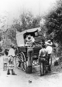
Negative - Photograph, Loading fruit for market, Kinglake, c.1895
Loading buckets of fruit, probably raspberries from "The Oaks" Thomson family property, Kinglake into a covered cart hitched to a horse by four hatted farm workers. Most likely the fruit was headed to the "jam factory" at Kinglake operated by the Kinglake Fruit Growers Preserving Company which was formed about 1900. The fruit was pulped as the first step in the process by beng cooked in a steam bolier. The barrels of processed druit pulpt were then transported in barrels by horse and cart to the Whittlesea railway station.This photo forms part of a collection of photographs gathered by the Shire of Eltham for their centenary project book,"Pioneers and Painters: 100 years of the Shire of Eltham" by Alan Marshall (1971). The collection of over 500 images is held in partnership between Eltham District Historical Society and Yarra Plenty Regional Library (Eltham Library) and is now formally known as 'The Shire of Eltham Pioneers Photograph Collection.' It is significant in being the first community sourced collection representing the places and people of the Shire's first one hundred years.Digital image 4 x 5 inch B&W Neg 12.5 x 9 cm printshire of eltham pioneers photograph collection, kinglake, harvesting, pioneers and painters, fruit industry, market garden -
 Eltham District Historical Society Inc
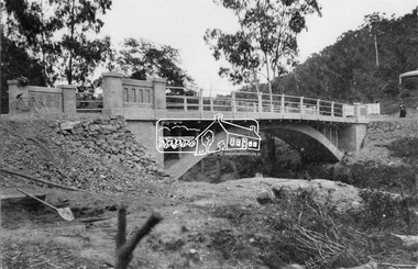
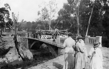
Negative - Photograph, New bridge at Hurstbridge, 1917
The newly constructed re-inforced concrete arched bridge across the Diamond Creek at Hurstbridge designed by John Monash. Eltham Shire shared the cost of the construction of the bridge with Heidelberg and Whittlesea Shires. The bridge was officially opened on 3rd November 1917. Part of a slide show presentation "Bridges & Waterways of the Shire" by Russell Yeoman to the 13 September 1989 Society meeting. The presentation included slides of historic photos from the Shire of Eltham Pioneers collections as well as several recent views.This photo forms part of a collection of photographs gathered by the Shire of Eltham for their centenary project book, "Pioneers and Painters: 100 years of the Shire of Eltham" by Alan Marshall (1971). The collection of over 500 images is held in partnership between Eltham District Historical Society and Yarra Plenty Regional Library (Eltham Library) and is now formally known as 'The Shire of Eltham Pioneers Photograph Collection.' It is significant in being the first community sourced collection representing the places and people of the Shire's first one hundred years.Digital image 4 x 5 inch B&W Negshire of eltham pioneers photograph collection, hurstbridge, bridge, 1917, diamond creek (creek), monash bridge -
 Eltham District Historical Society Inc
Newsletter, Eltham District Historical Society, Newsletter, No. 244 February 2019
Contents: • A Playful History by Jim Connor • Our February Meeting • March Excursion – Return to Research • You May Notice • Early Days Recalled At Eltham (Eltham and Whittlesea Shires Advertiser, 21 Nov 1941, p4) • Montmorency Press association – 1927 (Advertiser, 12 Aug 1927, p4) • An Eltham Road (The Argus, 27 Jul 1911, p5) • An Eltham Old resident (Advertiser, 19 Aug 1932, p6) • Eltham Cemetery Stories by Richard Pinn • Contacts for the Eltham District Historical Society The Shire of Eltham Historical Society was formed in October 1967. The first newsletter of the Society was issued May 1978 and has been published continuously ever since on a bi-monthly basis. With the cessation of the Shire of Eltham in late 1994, the Society's name was revised to Eltham District Historical Society and this name first appeared with issue No. 103, July 1995. The collection of the Society's newsletters provides a valuable resource on the history of the Society's activities, office bearers and committee members, guest speakers and subjects of historical interest pertinent to the former Shire of Eltham and the Eltham District.A4 newsletter distributed to membersnewsletter, eltham district historical society -
 Greensborough Historical Society
Map, Melbourne and Metropolitan Board of Works. Survey Division, MMBW, Yarra 2500 / 12.22. Watsonia North, 1978_03
Melbourne and Metropolitan Board of Works. Yarra 2500 [base map]. 12-22, Parishes of Keelbundora 2856, Municipalities of Whittlesea 239 and Diamond Valley 257. Shows street names, easement sizes, lot numbers, lodged plan numbers, names of prominent features, contour values, creek or river names. Watsonia Railway Station and environs. Prominent streets: Edmund Rice Parade and Macorna Street. Includes Christian Brothers Edmund Rice College and Janefield Special School sites and "proposed future freeway" (now Metropolitan Ring Road).MMBW Map in 1:2500 [scale] series. Cream parchment with green tape reinforcing on edges and punched holes on left edge.mmbw, melbourne and metropolitan board of works, shire of diamond valley, watsonia - maps, bundoora - maps -
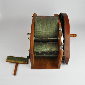 National Wool Museum
Tool - Drum Carder, Kacoonda, c.1980
This drum carder was purchase by Gill Stange at the Whittlesea Show in the late 1980s. The carder allowed Gill to spin fleece from her own Merino sheep. Merino is a difficult wool to spin when compared to other popular varieties, such as Corriedale or crossbred wool. The carder helped her to tease out the fleece, slightly separating the fibres before spinning. It also allowed for easier removal of foreign matters, such as seeds and mud. Little is known about the Kacoonda brand who produced the carder. They were Australian based and appear to have only operated throughout the 1980s.The carder has one large central roller with two smaller rollers on either side. The larger roller rotates in the inverse direction of the two smaller rollers. The carding cloth is a mint green in which closely spaced wire pins are embedded. The shape, length, diameter, and spacing of these wire pins is that of a standard carder. On one side of the carder a handle is found that is used to spin the three rollers. Additionally on this side is a sticker which reads “The Kacoonda Carder. Subject to Patent Action”. A Silver grip for the easy movement of the carder can also be found high on this side. On the opposite side of the carder, many nuts and plates can be found which hold the rollers in place. This is opposed to the other side of the carder, which has a brown plastic cover plate attached underneath the handle. The walls providing a path for the carded wool to follow when being carded, are made of wood. The carder comes complete with a teasing tool. This tool has the same mint green carding cloth as the carder’s rollers. It is attached to a simple wood handle for ease of use.Wording, green, printed. Sticker on side of carder. “The Kacoonda Carder / SUBJECT TO PATENT ACTION”whittlesea show, drum carder, textile production, carding wool, kacoonda -
 Eltham District Historical Society Inc
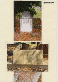
Folder, Andrew
James Andrew Kangaroo Ground, 1870 "James Andrew, Whittlesea, born in East Palford, Devonshire, England, in 1827, arrived in Adelaide in February 1850 per ship Lady McCaughton and almost immediately sailed in a coasting vessel to Melbourne, where the first work he undertook was clearing earth from a stone quarry in Collingwood. He next carried stones for masons engaged in building the Bishop’s Palace, and then was employed in Cambellfield mowing hay. He was at Saltwater River on Black Thursday, and afterwards took a little farm at Darebin Creek, remaining there for four years. He went up to Kangaroo Ground in 1859 and lived there until he bought his present property at Whittlesea, a farm of between 300 and 400 acres. He has been twice married, and had a family of six children." "Andrew, W. B. Eltham, is a native of England, born in 1822. Coming out to Australia in 1842, he lived in Brighton, Victoria for fifteen years, when he re-visited England for a year. Returning to Victoria fourteen or fifteen years ago, he commenced storekeeping at Eltham, where he has carried on that business ever since. Mr Andrew has always taken a lively interest in the public affairs of town and district” from "Victoria and its Metropolis: Past and Present" written in 1888 by Alexander Sutherland. Chapter 19, "The Upper Yarra District" pages [402] - 415. Includes descriptions of some townships and short biographies of local residents. Page 405 Folder of information on James Andrew, Trustee Kangaroo Ground Cemetery, Kangaroo Ground 1870 William Bravery Andrew, Eltham, 1870s-1880s Ernest James Andrew, Eltham, Eltham Shire Councillor, 1920s-1950 and Ellen Matilda Brown Andrewjames andrew, pioneer, kangaroo ground, ernest james andrew, william bravery andrew, ellen andrew, eltham cemetery, biography, ellen harper andrew (nee clarke), ellen matilda andrew (nee brown), eltham war memorial gate, eltham war memorial trust -
 Eltham District Historical Society Inc
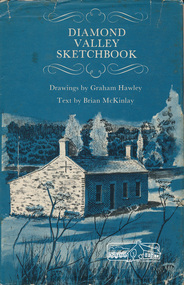
Book, Diamond Valley sketchbook / text by Brian McKinlay ; drawings by Graham Hawley, 1973
Contents include short articles and illustrations of historic properties within the municipalities of Banyule, Nillumbik and Whittlesea. Including The Griffin House, Rosehill, Lower Plenty, The Austin Hospital, Heidelberg, St John's Church, Heidelberg, Banyule, Heidelberg, Trestle Bridge, Eltham, Diamond Valley railway, The Shillinglaw Cottage, Eltham, Montsalvat, Old England Hotel, Heidelberg, Eltham Primary School, Mud brick homes, Eltham, Sweeney's Cottage, Eltham, Pound Pend Tunnel, The Gold Memorial, Potter's Cottage, Memorial Tower, Charterisville, Weller's Pub, The Barrel, Eltham, Hassall's Gallery, The Old Bridge, Greensborough, Diamond Valley Shire Offices, Greensborough, St Katherine's Chapel, Yan Yean Reservoir, Mernda Hotel, Mernda Mechanics Institute, Old Barn, Mernda, Parade College, La Trobe University.Hardback with jacket ; 63 p. : ill., maps ; 22cm. diamond valley shire, shire of nillumbik, city of whittlesea, city of banyule, shillinglaw cottage, weller's hotel -
 Eltham District Historical Society Inc
Negative - Photograph, Opening of the new bridge at Hurstbridge, 1917
The opening ceremony of new the bridge over the Diamond Creek at Hurstbridge, designed by Sir John Monash. The single arch concrete bride replaced the original wooden structure erected in 1881. People gathering around 3pm for the Official Opening of Hurst's Bridge, 3 November 1917. View of steam train at Hurstbridge Railway Station in distance. Part of a slide show presentation "Bridges & Waterways of the Shire" by Russell Yeoman to the 13 September 1989 Society meeting. The presentation included slides of historic photos from the Shire of Eltham Pioneers collections as well as several recent views. 1917 'HURST'S BRIDGE.', Eltham and Whittlesea Shires Advertiser and Diamond Creek Valley Advocate (Vic. : 1917 - 1922), 9 November, p. 3. (MORNING.), viewed 28 Jul 2018, http://nla.gov.au/nla.news-article57641838This photo forms part of a collection of photographs gathered by the Shire of Eltham for their centenary project book,"Pioneers and Painters: 100 years of the Shire of Eltham" by Alan Marshall (1971). The collection of over 500 images is held in partnership between Eltham District Historical Society and Yarra Plenty Regional Library (Eltham Library) and is now formally known as the 'The Shire of Eltham Pioneers Photograph Collection.' It is significant in being the first community sourced collection representing the places and people of the Shire's first one hundred years.Digital image 120 format B&W negativesepp, shire of eltham pioneers photograph collection, diamond creek, hurstbridge, wattle glen, bridge, mia mia, opening day, sir john monash -
 Eltham District Historical Society Inc
Document - Folder, Miscellaneous newsclippings pertaining to Eltham Public Hall (henry Street and Arthur Street), 1903-1951
CONCERT AT ELTHAM. (1902, June 20). Mercury and Weekly Courier (Vic. : 1878 - 1903), p. 3. Retrieved November 22, 2024, from http://nla.gov.au/nla.news-article58580761 NEW PUBLIC HALL AT ELTHAM. (1921, December 2). Eltham and Whittlesea Shires Advertiser and Diamond Creek Valley Advocate (Vic. : 1917 - 1922), p. 3 (MORNING.). Retrieved November 22, 2024, from http://nla.gov.au/nla.news-article57640472 ELTHAM HALL (1924, February 22). Advertiser (Hurstbridge, Vic. : 1922 - 1939), p. 3 (AFTERNOON). Retrieved November 22, 2024, from http://nla.gov.au/nla.news-article56656807 THE Eltham and Whittlesea Shires Advertiser AND Diamond Creek Valley Advocate (1925, February 6). Advertiser (Hurstbridge, Vic. : 1922 - 1939), p. 2 (AFTERNOON). Retrieved November 22, 2024, from http://nla.gov.au/nla.news-article56658074 ELTHAM PUBLIC HALL. (1927, January 21). Advertiser (Hurstbridge, Vic. : 1922 - 1939), p. 3 (AFTERNOON.). Retrieved November 22, 2024, from http://nla.gov.au/nla.news-article57754280 ELTHAM. (1927, January 28). Advertiser (Hurstbridge, Vic. : 1922 - 1939), p. 3 (AFTERNOON.). Retrieved November 22, 2024, from http://nla.gov.au/nla.news-article57754308 ELTHAM. (1929, February 15). Advertiser (Hurstbridge, Vic. : 1922 - 1939), p. 2 (AFTERNOON.). Retrieved November 22, 2024, from http://nla.gov.au/nla.news-article57759218 ELTHAM PUBLIC HALL. (1929, March 1). Advertiser (Hurstbridge, Vic. : 1922 - 1939), p. 3 (AFTERNOON.). Retrieved November 22, 2024, from http://nla.gov.au/nla.news-article57759343 Eltham Council; Items of Interest (1951, September), Heidelberger, p1 – Eltham Public Hall Committee granted Council approval to purchase two shop frontage blocks next to shire hall. Traces the earliest history of the Eltham Public Hall in Henry Streeteltham public hall, eltham shire hall, henry street, eltham rechabite hall, arthur street -
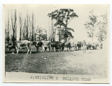 Orbost & District Historical Society
black and white photograph, late 19th century - early 20th century
Aged 19 James Stirling arrived in Melbourne on January 26, 1842 with his family - parents, three sisters and two brothers. James Stirling moved around a lot to Whittlesea, Ballarat goldfields, Cunninghame, (now Lakes Entrance), then to the Old Station about 36 miles to the east along the coast near the mouth of the Snowy River and for a time settled there with his wife also from Wigton, Scotland, and their family four sons two daughters (James, John, William, George, Margaret and Polly). The first settler to occupy the Marlo township area was James Stirling around the year 1875. He built a bark hut on the bluff that had two rooms, bark walls, earthen floors and a shingle roof. By 1884, this structure had expanded to a 9 roomed accommodation house and in 1886 became the Marlo Hotel when a liquor license was granted. (more information from “Snowy River Mail”, Wednesday, April 13th 1977: MEMORIES OF MARLO by Mrs Elsbeth Conlon (nee Stirling ) During the 19th century bullock teams were the most effective means of transporting people and goods inland, as the roads were badly made and in poor condition. The better roads were closer to the towns, and the further away from the town, the worse the conditions of the roads. Bullock teams drew heavily laden carts full of provisions, equipment and people from town to town and into the countryside to isolated homes. This item is associated with that era. It is also associated with James Sterling a very early settler of Marlo.A black / white photograph of a bullock team with a man standing beside it.on front - J STIRLING S BULLOCK TEAMstirling-james marlo-history bullock-team transport -
 Eltham District Historical Society Inc
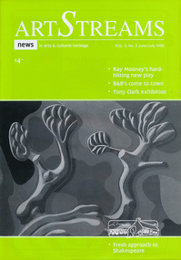
Journal, Peter Doughtery, ArtStreams: News in arts and cultural heritage; Vol. 3, No. 3, Jun-Jul 1998, 1998
Vol. 3, No. 3, Jun-Jul 1998 CONTENTS BANNERS MAKE A MARK Whittlesea lifts its arts profile 2 THE DROVER'S BOY A new play by Ray Mooney 3 HOME AWAY FROM HOME Nillumbik finally discovers a new tourist potential 5 OUT OF DESIGN, INTO ART A tour of Tony Clark's public and private paintings at Heide 7 BOOK REVIEW The Blue Gate, by Alison Groggon 11 THE ACCIDENTAL ARCHIVE The work of Jenni Mitchell 12 GOING IT ALONE David Moore make a critical decision 14 ENTERTAINMENT Pictorial round-up of local artists 16 A WAY WITH BOOKS Kay Sagar sets the scene in schools 18 SHORT STORY BY JON WEAVING 19 THEATRE WITH CAROLYN PICKETT 22 BOOK REVIEW - NICE TRY 25 CD REVIEW 26 PLEASURE IN ART Interview with Marian Sussex, aged 82 27 FRESH APPROACH TO SHAKESPEARE 29 ARTS SERVICES & TEACHING 30 WINING, DINING & ENTERTAINING 31 New looks in local parks 32 "Peter Dougherty has been involved in the local art scene for many years. As publisher and editor of the arts magazine Artstreams, his comments on the various branches of the arts are widely respected. His "The Arts" column in the Diamond Valley Leader presents a brief summary for a much wider cross section of the local community. Peter also operates his own gallery and the Artstreams Cafe at the St Andrews market. Peter has a wealth of knowledge about present day and historical aspects of local art and artists." - Eltham District Historical Society Newsletter No. 161, March 2005Colour front and back cover with feature articles and literary pieces with photographs and advertisements printed in black and white. 36 pages, 30 cm. Vol. 1, no. 1 (Nov. 1996) - Vol. 10, no. 5 (summer ed. 2005/06) art streams, were street cafe, sam alessi, plenty ranges arts and convention centre, ray mooney, dymocks booksellers, adams of north riding, bed and breakfasts, b&b, eltham garden retreat, tony clark, eltham library community gallery, alison croggan, ian mcbryde, ward sagar, jenni mitchell, emma lew, ken taylor, pietro ristorante grossi, david moore, dynamic vegies, yarra valley country club, tim mclean, petery haydon, mirth, volumes, cate bailey, songlines, jane mcgeogh-brittan, azure, margaret roadknight, mezze restaurant warrandyte, andre mcauley, robbie grieg, melanie shanahan, ricky ozimo, george dreyfus, sebastian jorgensen, angie mcmillan, kay sagar, jon weaving, heidelberg thearte company, carolyn pickett, llobex image wizards, shane moloney, michelle lonsdale, birrarung, anglea abbot, don james, john wakefield, la piazza restaurant bar & cafe, eltham high school, kavisha mazzello, robbie grieg, recherche speciality picture framing, marian sussex, maree wesols, anne maree graham, art in public places, albert tucker, museum of modern art at heide, montsalvat -
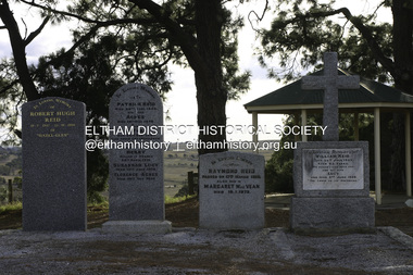 Eltham District Historical Society Inc
Photograph - Digital Photograph, Alan King, Reid family graves, Arthurs Creek Cemetery, 30 March 2008
The Arthurs Creek Cemetery was originally the private cemetery of pioneers Agnes and Patrick Reid. Published: Nillumbik Now and Then / Marguerite Marshall 2008; photographs Alan King with Marguerite Marshall.; p11 The Hazel Glen property, at Middle Hut Road, Arthurs Creek, which includes one of Victoria’s earliest pioneer buildings, was the forerunner to the Arthurs Creek and Doreen townships. At one time the Doreen Post Office and school were called Hazel Glen. The Hazel Glen State School No 945, before it was moved to its present site, stood on land to the south of Chapel Lane, which had been donated by Hazel Glen owner, William Reid. In May 1895 the post office was renamed Doreen to avoid confusion with the Reid’s address. The Arthurs Creek Cemetery was originally the private cemetery of Hazel Glen pioneers Agnes and Patrick Reid. The Reids with their eight children, arrived in Melbourne in April 1839. In 1844 Patrick Reid took over the licence to the Stewart Ponds run of 5120 acres (2072ha). Reid renamed it Hazel Glen, after Hazelden, the name of the Reid estate at Mearns in Renfrewshire, Scotland. Reid built a small cottage from local stone and hand-made bricks, with walls one yard (91 cm) thick, a flagstone floor and a shingle roof. Today two rooms and a store room survive as part of a larger house. Agnes died in 1847 aged 49, and was buried on a hill overlooking Hazel Glen, where it is said she had asked to be buried as it had been a favourite picnic spot.2 In 1858 Patrick died aged 74, and was buried near her. Their son William was to become Whittlesea Shire’s first president. From 1868 he was a Whittlesea Roads Board member, then a shire councillor until shortly before his death in 1923 aged 88. In 1865 the Reid’s burial area was no longer on their property, so it was declared a cemetery site. In 1867 it became the Linton Public Cemetery, being in the Linton Parish. However, to avoid confusion with Linton near Ballarat, the cemetery was renamed the Arthurs Creek Public Cemetery in 1926. Arthurs Creek was named after Henry Arthur, a pastoralist and public servant, who ran 1000 sheep lower down the Creek, from 1836 to 1841. It is believed he built his home at the end of today’s Challenger Street in Diamond Creek.This collection of almost 130 photos about places and people within the Shire of Nillumbik, an urban and rural municipality in Melbourne's north, contributes to an understanding of the history of the Shire. Published in 2008 immediately prior to the Black Saturday bushfires of February 7, 2009, it documents sites that were impacted, and in some cases destroyed by the fires. It includes photographs taken especially for the publication, creating a unique time capsule representing the Shire in the early 21st century. It remains the most recent comprehenesive publication devoted to the Shire's history connecting local residents to the past. agnes reid, arthurs creek cemetery, nillumbik now and then (marshall-king) collection, patrick reid, reid family -
 Eltham District Historical Society Inc
Photograph, Shire of Nillumbik World War One Memorials tour, 10 August 2016, 10 August 2016
Memories Memories of a boyhood's day. When he went to scahool away Letters in a schoolboy's hand. telling of the things he's planned, Linned in colours bright and fair - THESE - are what I have to-night. Visions of a soldier-led, In his dress of khaki clad, Saying, "Mohter, do not grieve." When he has his final leave. His dear face, and my dimmed signt THESE - are what I have to-night. R.M. Conway, Christmas Hills From the Eltham and Whittlesea Shire Advertiser and Diamond Creek Advocate, 13 December 1918. As part of a program to acknowledge the Anzac Centenary Nillumbik Shire Council partnered with Yarra Plenty Regional Library to provide a bus tour with commentary of local sites of significance. These included Eltham township, the Shire of Eltham War Memorial at Kangaroo Ground, Christmas Hills, Hurstbridge memorial recreation park and finished at Eltham Library to view the Writing the War exhibtion at Eltham Library Community Gallery. In May 2015 Nillumbik Shire Council received Anzac centenary Local Grants Program funding for the restoration and enhancement of Christmas Hills cenotaph as a project to commemorate the First World War. Born Digitalworld war 1, war memorials, shire of nillumbik, christmas hills, interpretative signage, poem, "r.m. conway" -
Eltham District Historical Society Inc
Document - Folder, Pelling, Charis
Charis Pelling, daughter of Professor William Osborne and Dr Ethel Osborne, was active in local activities, including being Eltham Shire's first female president and a councillor. Contents Newspaper articles: About Whittlesea Show 1964, Diamond Valley News, 1964 (photocopy). Magazine article: "A woman who gets things done", The Australian Women's Weekly, 26 October 1966. Charis Pelling's life and activities. Note card: Thanks for sympathy following destruction of "Woodlands" and "The Hall" in 8 January 1969 bushfire. Newspaper article: "Quietly proud of her life", Diamond Valley News, 19 June 1984. Charis Pelling's childhood and activities. Note card: Thanks for sympathy following death of Edwin Oswald Pelling. Newspaper notice: Death notice, Charis Meta Aleander Pelling. Order of Service: Celebration of life of Charis Meta Aleander Pelling, 2006. Letter: Eltham District Historical Society to Charis Pelling, 21 June 1995, Invitation to be presented with certificate to her as foundation President of the Society. Note card: Charis Pelling, Thanks for presentation. Newsletter: Eltham District Historical Society, number 172, January 2007. Obituary of Charis Meta Alexander Pelling.Newspaper clippings, A4 photocopies, etccharis pelling, whittlesea show, kangaroo ground victoria, michael pelling, margaret pelling, nicholas pelling, deborah pelling, warrandyte water works trust, eltham arts council, eltham old people's committee, eltham art show, shillinglaw cottage preservation committee, woodlands kangaroo ground victoria, gareth jones roberts, peter glass, alkis astrix, matcham skipper, mervyn horton, the flavor of eltham, bush fire january 1969, the hall kangaroo ground victoria, professor william osborne, dr ethel osborne, william pelling, alistair knox, harold bartlett, gerald yunken, edwin oswald pelling, charis meta alexander pelling -
 Eltham District Historical Society Inc
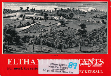
Book, Kenneth Eric Eckersall, Eltham inhabitants : for most, the serious part : church in community 1850-2000 / Kenneth Eric Eckersall, 2000
ArtStreams: Arts in Banyule, Darebin, Manningham, Nillumbik, Whittlesea & Yarra Vol. 5 No. 6 Summer Issue, 2000 Book Review "Ken Eckersall has been a member of the Eltham community for 40 years. He has been a member of the Methodist / Uniting Church for all of his 66 years. Having moved from being a compositer in the printing trade to a teacher and lecturer, in his retirement he has become an historian. Eltham Inhabitants is ostensibly a history of the Eltham Uniting Church, written to celebrate its 150th anniversary. The book is considerably broader than the commission suggests. This is hinted at in Eckersalls reference to the Eltham Wesleyan/Methodist/Uniting Church. Eckersall writes on the history and philosophy of the church from its beginnings in the 18th century to the present and places it in the context of the sociology and history of the period. Recognising the nexus between church and community, the author has in large part written a history of the Eltham community including the churches of other denomination(s). There are very few artists, academics or other interesting characters from the district who don't get a mention. Despite a plethora of information about the church, Eltham Inhabitants is a fund of historical information on many other fronts."Paperback; viii, 175 p. : ill. ; 21 cm. 2 copieseltham, churches, uniting church, eltham uniting church -
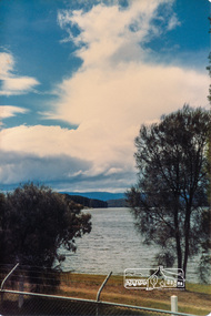
 Eltham District Historical Society Inc
Photograph, Yan Yean, 1987, 1987
Originally contained in a 'magnetic' photo album of scenic photos of Yan Yean and Warrandyte believed to be donated by Mrs Eric Stephenson, Jingalong, 110 Ryans Road, Eltham, Vic. 3095; relocated to archival safe storage. On the 20th December 1853 Lieut Governor Charles LaTrobe took his spade to turn the first sod of an embankment across the swampy bed of the Plenty River at a lonely place called Yan Yean, in order to create Melbourne’s first water supply. In the early 1850’s water had been drawn from the Yarra which even then was known as Yarra Soup. A convict by the name of James Blackburn produced the basic design for supplying water to Melbourne from a reservoir on the Plenty River at Yan Yean, and later on he was appointed consulting engineer on the project. In 1853 a contract was let for the building of the wall for 91 thousand 575 pounds, and at one stage some 400 labourers were at work in the area. A tramway was constructed to convey stone and other materials from Melbourne. So famous was this magnificent stretch of water that illustrations of the bluestone embankment and tower appeared in London journals Whittlesea Historical Society – Historic items for Diamond Valley Community Radio September 1990 Colour photographyan yean, yan yean reservoir -
 Eltham District Historical Society Inc
Photograph, Yan Yean, 1987, 1987
Originally contained in a 'magnetic' photo album of scenic photos of Yan Yean and Warrandyte believed to be donated by Mrs Eric Stephenson, Jingalong, 110 Ryans Road, Eltham, Vic. 3095; relocated to archival safe storage. On the 20th December 1853 Lieut Governor Charles LaTrobe took his spade to turn the first sod of an embankment across the swampy bed of the Plenty River at a lonely place called Yan Yean, in order to create Melbourne’s first water supply. In the early 1850’s water had been drawn from the Yarra which even then was known as Yarra Soup. A convict by the name of James Blackburn produced the basic design for supplying water to Melbourne from a reservoir on the Plenty River at Yan Yean, and later on he was appointed consulting engineer on the project. In 1853 a contract was let for the building of the wall for 91 thousand 575 pounds, and at one stage some 400 labourers were at work in the area. A tramway was constructed to convey stone and other materials from Melbourne. So famous was this magnificent stretch of water that illustrations of the bluestone embankment and tower appeared in London journals Whittlesea Historical Society – Historic items for Diamond Valley Community Radio September 1990Colour photographyan yean, yan yean reservoir -
 Eltham District Historical Society Inc
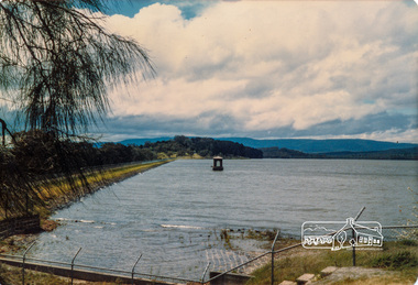
Photograph, Yan Yean Reservoir
Originally contained in a 'magnetic' photo album of scenic photos of Yan Yean and Warrandyte believed to be donated by Mrs Eric Stephenson, Jingalong, 110 Ryans Road, Eltham, Vic. 3095; relocated to archival safe storage. On the 20th December 1853 Lieut Governor Charles LaTrobe took his spade to turn the first sod of an embankment across the swampy bed of the Plenty River at a lonely place called Yan Yean, in order to create Melbourne’s first water supply. In the early 1850’s water had been drawn from the Yarra which even then was known as Yarra Soup. A convict by the name of James Blackburn produced the basic design for supplying water to Melbourne from a reservoir on the Plenty River at Yan Yean, and later on he was appointed consulting engineer on the project. In 1853 a contract was let for the building of the wall for 91 thousand 575 pounds, and at one stage some 400 labourers were at work in the area. A tramway was constructed to convey stone and other materials from Melbourne. So famous was this magnificent stretch of water that illustrations of the bluestone embankment and tower appeared in London journals Whittlesea Historical Society – Historic items for Diamond Valley Community Radio September 1990 Colour photographyan yean, yan yean reservoir -
 Eltham District Historical Society Inc
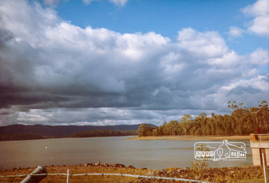
Photograph, Yan Yean, 1988, 1988
Originally contained in a 'magnetic' photo album of scenic photos of Yan Yean and Warrandyte believed to be donated by Mrs Eric Stephenson, Jingalong, 110 Ryans Road, Eltham, Vic. 3095; relocated to archival safe storage. On the 20th December 1853 Lieut Governor Charles LaTrobe took his spade to turn the first sod of an embankment across the swampy bed of the Plenty River at a lonely place called Yan Yean, in order to create Melbourne’s first water supply. In the early 1850’s water had been drawn from the Yarra which even then was known as Yarra Soup. A convict by the name of James Blackburn produced the basic design for supplying water to Melbourne from a reservoir on the Plenty River at Yan Yean, and later on he was appointed consulting engineer on the project. In 1853 a contract was let for the building of the wall for 91 thousand 575 pounds, and at one stage some 400 labourers were at work in the area. A tramway was constructed to convey stone and other materials from Melbourne. So famous was this magnificent stretch of water that illustrations of the bluestone embankment and tower appeared in London journals Whittlesea Historical Society – Historic items for Diamond Valley Community Radio September 1990 Colour photographyan yean, yan yean reservoir -
 Eltham District Historical Society Inc
Photograph, Flowering Gum at Yan Yean, 1988, 1988
Originally contained in a 'magnetic' photo album of scenic photos of Yan Yean and Warrandyte believed to be donated by Mrs Eric Stephenson, Jingalong, 110 Ryans Road, Eltham, Vic. 3095; relocated to archival safe storage. On the 20th December 1853 Lieut Governor Charles LaTrobe took his spade to turn the first sod of an embankment across the swampy bed of the Plenty River at a lonely place called Yan Yean, in order to create Melbourne’s first water supply. In the early 1850’s water had been drawn from the Yarra which even then was known as Yarra Soup. A convict by the name of James Blackburn produced the basic design for supplying water to Melbourne from a reservoir on the Plenty River at Yan Yean, and later on he was appointed consulting engineer on the project. In 1853 a contract was let for the building of the wall for 91 thousand 575 pounds, and at one stage some 400 labourers were at work in the area. A tramway was constructed to convey stone and other materials from Melbourne. So famous was this magnificent stretch of water that illustrations of the bluestone embankment and tower appeared in London journals Whittlesea Historical Society – Historic items for Diamond Valley Community Radio September 1990 Colour photographyan yean -
 Eltham District Historical Society Inc
Photograph - Digital Photograph, Alan King, Kinglake National Park, 27 March 2008
Fern gullies around Jehosaphat Gully Covered under National Estate. Published: Nillumbik Now and Then / Marguerite Marshall 2008; photographs Alan King with Marguerite Marshall.; p125 The magnificent Kinglake National Park, fringing Nillumbik’s north, is the largest national park close to Melbourne. Thanks to the vision and hard work of a band of local people, the park was created from what was rapidly becoming degraded land. Seeing a threat to Kinglake’s indigenous flora and fauna, several prominent local people campaigned for a national park, which was established in 1928.1 Since then, the park has grown through donations and acquisitions of land, from around 13,800 acres of land (5585ha) to 22,360 hectares. The Sugarloaf and Everard Blocks – of almost 8000 hectares – stand in Nillumbik and the park extends into Mitchell and Murrundindi Shires and the City of Whittlesea. Mt Everard commemorates William Hugh Everard, State member for Evelyn when the park was established. Before 1928, European settlers had degraded the Kinglake area, which was named after the celebrated English author and lawyer, Alexander William Kinglake. Remains of gold shafts and diggings in the park are reminders of Kinglake’s first settlers, who hoped to strike it rich at the gold diggings. But like other gold fields in this shire, they proved not very lucrative and soon timber cutting replaced mining in importance. However, before long, the accessible timber supply ran out, so in the 1920s agriculture took over – particularly potatoes and berry fruits – which involved large-scale clearing.2 The park’s instigator was retired Melbourne University Professor of Music, William Laver.3 As chair of the Kinglake Progress Association he began negotiations to have crown lands on the southern scarp of the Great Dividing Range reserved as a national park. Even before the park was proclaimed, from 1927, KPA members cut tracks to the major scenic points. Professor Laver was one of several people who gave land for the park, donating around 50 acres (20ha), including the Jehosaphat Gully.4 Laver chaired the park’s first Committee of Management, which raised money to employ a ranger and provide facilities, including tracks and roads for fire protection vehicles, toilets and shelters. The committee charged fees for firewood collection, some grazing of livestock, and visitor entrance, and obtained small State Government and Eltham Shire grants. In 1957 the State Government provided revenue for national parks. Then, in 1975, the State Government took over the management and the Committee of Management became an advisory committee, which disbanded in 1978. Originally, the park covered crown land in the Shires of Eltham and Whittlesea; then Wombelano Falls in Yea and other areas were added. In 1970 the park extended into the Shires of Eltham, Healesville, Whittlesea and Yea.5 Bush fires have been an ongoing problem. In 1939 hundreds of eucalypts and acacias had to be sown around the Jehosaphat Gully to rejuvenate the forest. To manage bushfires, the Committee of Management, then the State Government, worked closely with the Forestry Commission, shire councils and local fire brigades. Early national parks focussed on recreation. But by the 1980s, conservation, education and scientific research became more important, playing a vital role in preserving representative samples of the natural environment. Each year many thousands of people use the park’s extensive network of walking tracks amongst the protected plant and animal life as well as camping, cycling and horse riding. The park, along the slopes of the Great Dividing Range, has lookouts revealing magnificent views of the Melbourne skyline, Port Phillip Bay, the Yarra Valley and the You Yangs. Vegetation in the Masons Falls area includes messmate forest, Austral grass-trees, ferns and Hazel Pomaderris. In spring, orchids, lilies, everlasting daisies, correas, grevillea and heath appear. Around Jehosaphat Gully are wet and dry forest, fern gullies and banksia. Animal life includes wallabies, kangaroos, koalas, echidnas, possums, gliders and bandicoots. Male lyrebirds can be heard mimicking in the Jehosaphat Gully, particularly in the Everard Block in winter.This collection of almost 130 photos about places and people within the Shire of Nillumbik, an urban and rural municipality in Melbourne's north, contributes to an understanding of the history of the Shire. Published in 2008 immediately prior to the Black Saturday bushfires of February 7, 2009, it documents sites that were impacted, and in some cases destroyed by the fires. It includes photographs taken especially for the publication, creating a unique time capsule representing the Shire in the early 21st century. It remains the most recent comprehenesive publication devoted to the Shire's history connecting local residents to the past. nillumbik now and then (marshall-king) collection, kinglake national park, jehosaphat gully -
 Orbost & District Historical Society
black and white photograph, July 1922
Jean Stirling , born 1901 in Orbost, married Charles Frances Reginald Joyes on 15th July 1922 in Orbost. Jean's father was John Stirling, son of James Stirling and Ann Gray. Her mother was Robina Harvey McNair, Aged 19 James Stirling arrived in Melbourne on January 26, 1842 with his family - parents, three sisters and two brothers. James Stirling moved around a lot to Whittlesea, Ballarat goldfields, Cunninghame, (now Lakes Entrance), then to the Old Station about 36 miles to the east along the coast near the mouth of the Snowy River and for a time settled there with his wife also from Wigton, Scotland, and their family four sons two daughters (James, John, William, George, Margaret and Polly). The first settler to occupy the Marlo township area was James Stirling around the year 1875. He built a bark hut on the bluff that had two rooms, bark walls, earthen floors and a shingle roof. By 1884, this structure had expanded to a 9 roomed accommodation house and in 1886 became the Marlo Hotel when a liquor license was granted. (more information from “Snowy River Mail”, Wednesday, April 13th 1977: MEMORIES OF MARLO by Mrs Elsbeth Conlon (nee Stirling )This photograph is associated with the Stirling family early settlers of Marlo. It is also a pictorial record of styles of wedding dress popular in the 1920s.A black / white studio portrait / photograph of a bridal couple. The bride on the left is wearing a typical 1920s wedding dress. tTe front is short with a hem that is in different length in front than behind. She is wearing a hat in the cloche-style. She is holding a bouquet of flowers and her train is draped to the left. The groom is wearing a three piece morning suit. he has a with a wingtip collar white dress shirt and a cravat tie.on front - hand - written "Jean Stirling's wedding (Marlo) ? Joyce"stirling-jean-wedding melba-&co wedding-clothing-1920s joyes-charles-francis-reginald -
 Eltham District Historical Society Inc
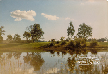
Photograph - Digital Photograph, Alan King, Blue Lake, Plenty Gorge Park, 2008
A quarry was transformed into the Blue Lake. Published: Nillumbik Now and Then / Marguerite Marshall 2008; photographs Alan King with Marguerite Marshall.; p179 The dramatic steep-sided Plenty Gorge lies along the divide of two geological areas, and separates the Nillumbik Shire and the City of Whittlesea. On the Nillumbik side are undulating hills and sedimentary rock, and in Whittlesea, lies a basalt plain formed by volcanic action up to two million years ago. This provides the Plenty Gorge Park with diverse vegetation and habitats, making it one of Greater Melbourne’s most important refuges for threatened and significant species. The park, established in 1986, consists of around 1350 hectares, and extends 11 kilometres along the Plenty River, from Greensborough to Mernda. It provides a wildlife corridor for around 500 native plant and 280 animal species. The area’s plentiful food and water attracted the Wurundjeri Aboriginal people and then European settlers. By 1837 squatters had claimed large runs of land for their sheep and cattle. The Plenty Valley was among the first in the Port Phillip District to be settled - mainly in the less heavily timbered west - and was proclaimed a settled district in 1841.But by the late 1880s, the settlers’ extensive land clearing for animal grazing, then agriculture, depleted the Wurundjeri’s traditional food sources, which helped to drive them away. Many Wurundjeri artefacts remain (now government protected), and so far 57 sites have been identified in the park, including scarred trees, burial areas and stone artefacts. Pioneer life could be very hard because of isolation, flooding, bushfires and bushrangers. Following the Black Thursday bushfires of 1851, basalt was quarried to build more fire-resistant homes. Gold discoveries in the early 1850s swelled the population, particularly around Smugglers Gully; but food production made more of an impact. In the late 1850s wheat production supplanted grazing. In the 1860s the government made small holdings available to poorer settlers. These had the greatest effect on the district, particularly in Doreen and Yarrambat, where orchards were established from the 1880s to 1914. Links with a prominent early family are the remains of Stuchbery Farm, by the river’s edge bounded by Smugglers Gully to the north and La Trobe Road, Yarrambat, to the east. The Stuchberys moved to the valley in 1890, and the family still lives in the area. In 1890, Alfred and Ada first lived in a tent where four children were born, then Alfred built the house and outbuildings around 1896. They planted an orchard, then a market garden, and developed a dairy. The family belonged to the local Methodist and tennis communities. Their grandson Walter, opened the Flying Scotsman Model Railway Museum in Yarrambat, which his widow, Vi, continues to run. Wal was also the Yarrambat CFA Captain for 22 years until 1987. Walter sold 24 hectares in 1976 for development - now Vista Court - and in 1990, the remaining 22.6 hectares for the park. Remaining are an early stone dairy and remnants of a stone barn, a pig sty and a well. Until it was destroyed by fire in 2003, a slab hut stood on the Happy Hollow Farm site, at the southern end of the park. The hut is thought to have been built in the Depression around 1893. This was a rare and late example of a slab hut with a domestic orchard close to Melbourne. Emmet Watmough and his family first occupied the hut, followed by a succession of families, until the Bell family bought it around 1948. There they led a subsistence lifestyle for 50 years, despite encroaching Melbourne suburbia. The Yellow Gum Recreation Area includes the Blue Lake, coloured turquoise at certain times of the year. Following the 1957 bushfires, this area was quarried by Reid Quarries Pty Ltd for Melbourne’s first skyscrapers, then by Boral Australia. However in the early 1970s water began seeping into the quarry forming the Blue Lake and the quarry was closed. The State Government bought the site in 1997 and opened it as a park in 1999.This collection of almost 130 photos about places and people within the Shire of Nillumbik, an urban and rural municipality in Melbourne's north, contributes to an understanding of the history of the Shire. Published in 2008 immediately prior to the Black Saturday bushfires of February 7, 2009, it documents sites that were impacted, and in some cases destroyed by the fires. It includes photographs taken especially for the publication, creating a unique time capsule representing the Shire in the early 21st century. It remains the most recent comprehenesive publication devoted to the Shire's history connecting local residents to the past. nillumbik now and then (marshall-king) collection, blue lake, plenty gorge park -
 Eltham District Historical Society Inc
Negative - Photograph, Opening of St. Andrews Battery, Queenstown, 29 Aug. 1919
Reproduced on p31 of 'Pioneers & Painters' Was destroyed in 1962 bushfire. Now Peter Franks Reserve, St Andrews On Friday 29th (August 1919) …, the Hon. S. Barnes, M. L. A., Minister of Mines, accompanied by Mr W. Everard, M.L.A., Mr. V. Dickson, secretary for Mines, and Mr. Merrin, Chief Mining Inspector, visited Smith's Gully for the purpose of opening, the new Government battery which has recently been erected. The party arrived punctually at 12.30, and was received by an assemblage of about 200 residents, including, those representing local prospecting and mining interests. At the mill house the Minister wished prosperity to mining on the old Queenstown field, and, in a few appropriate remarks, gave the battery the name of St. Andrew's. Then, as the stamps began to fall, three hearty cheers were given by the gathering. ….. The Queenstown field, dating back to the early sixties, might be regarded as a link that took them back to the Augustine age of gold mining in Victoria…From 1868 to 1918 the total yield of gold from the field was 274,606 fine oz. It might be that here, as elsewhere, deeper prospecting would give new life to the Queenstown goldfield. The miners of Queenstown, who through long year's had never lost faith in the possibilities of the field, felt that the purpose for which they were that day marked the beginning of a new era in the history of local reefing. …. The new mill is situated on the bank of the creek opposite the Queenstown Cemetery, and consists of a five head battery (Berdan pan) and 12 h.p. portable steam engine housed in a spacious structure of wood and iron. A concrete weir across the creek provides a good water supply, and all the necessary pumps, settling dams, etc., have been installed. Later on, should circumstances warrant it, it is pro-posed to erect Wilfley tables for concentrates. Eltham and Whittlesea Shires Advertiser and Diamond Creek Valley Advocate, Friday 5 September 1919, page 3This photo forms part of a collection of photographs gathered by the Shire of Eltham for their centenary project book,"Pioneers and Painters: 100 years of the Shire of Eltham" by Alan Marshall (1971). The collection of over 500 images is held in partnership between Eltham District Historical Society and Yarra Plenty Regional Library (Eltham Library) and is now formally known as the 'The Shire of Eltham Pioneers Photograph Collection.' It is significant in being the first community sourced collection representing the places and people of the Shire's first one hundred years.Digital image 4 x 5 inch B&W Neg Print 20 x 25 (2)shire of eltham pioneers photograph collection, queenstown, st andrews, st. andrews battery, gold mining, s. barnes, merrin, st andrews battery, v. dickson, william h. everard, peter franks reserve