Showing 3481 items
matching collection -- kew historical society
-
 Kew Historical Society Inc
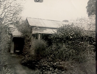
Photograph, 'Rangeview', Mary Street, c.1960
This work forms part of the collection assembled by the historian Dorothy Rogers, that was donated to the Kew Historical Society by her son John Rogers in 2015. The manuscripts, photographs, maps, and documents were sourced by her from both family and local collections or produced as references for her print publications. Many were directly used by Rogers in writing ‘Lovely Old Homes of Kew’ (1961) and 'A History of Kew' (1973), or the numerous articles on local history that she produced for suburban newspapers. Most of the photographs in the collection include detailed annotations in her hand.The Rogers Collection provides a comprehensive insight into the working habits of a historian in the 1960s and 1970s. Together it forms the largest privately-donated collection within the archives of the Kew Historical Society.Small black and white photograph of 'Rangeview', Mary Street, Kew."2"historic houses -- kew (vic.), rangeview -- mary street -- kew (vic.) -
 Kew Historical Society Inc
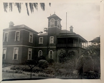
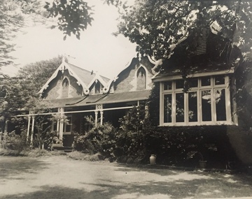
Photograph, 'Campion Hall', Studley Park Road, c.1960
This work forms part of the collection assembled by the historian Dorothy Rogers, that was donated to the Kew Historical Society by her son John Rogers in 2015. The manuscripts, photographs, maps, and documents were sourced by her from both family and local collections or produced as references for her print publications. Many were directly used by Rogers in writing ‘Lovely Old Homes of Kew’ (1961) and 'A History of Kew' (1973), or the numerous articles on local history that she produced for suburban newspapers. Most of the photographs in the collection include detailed annotations in her hand.The Rogers Collection provides a comprehensive insight into the working habits of a historian in the 1960s and 1970s. Together it forms the largest privately-donated collection within the archives of the Kew Historical Society.Small black and white photograph of 'Campion Hall' (also known as Dalsraith, Dalswraith, Glendalough) in Studley Park Road, Kew."17"historic houses -- kew (vic.), campion house -- campion hall, dalsraith -- dalswraith, glendalough, mansions -- studley park road -- kew (vic), ussher and kemp -
 Kew Historical Society Inc
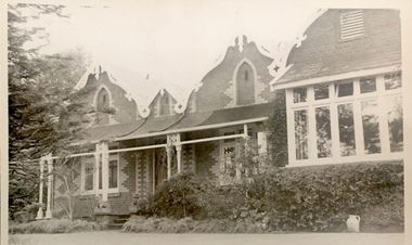
Photograph, 'Roseneath', Pakington Street, c.1960
This work forms part of the collection assembled by the historian Dorothy Rogers, that was donated to the Kew Historical Society by her son John Rogers in 2015. The manuscripts, photographs, maps, and documents were sourced by her from both family and local collections or produced as references for her print publications. Many were directly used by Rogers in writing ‘Lovely Old Homes of Kew’ (1961) and 'A History of Kew' (1973), or the numerous articles on local history that she produced for suburban newspapers. Most of the photographs in the collection include detailed annotations in her hand.The Rogers Collection provides a comprehensive insight into the working habits of a historian in the 1960s and 1970s. Together it forms the largest privately-donated collection within the archives of the Kew Historical Society.Small black and white photograph of 'Roseneath' in Pakington Street, Kew."34"historic houses -- kew (vic.), roseneath -- pakington street -- kew (vic.) -
 Kew Historical Society Inc
Photograph, 'Roseneath', Pakington Street, c.1960
This work forms part of the collection assembled by the historian Dorothy Rogers, that was donated to the Kew Historical Society by her son John Rogers in 2015. The manuscripts, photographs, maps, and documents were sourced by her from both family and local collections or produced as references for her print publications. Many were directly used by Rogers in writing ‘Lovely Old Homes of Kew’ (1961) and 'A History of Kew' (1973), or the numerous articles on local history that she produced for suburban newspapers. Most of the photographs in the collection include detailed annotations in her hand.The Rogers Collection provides a comprehensive insight into the working habits of a historian in the 1960s and 1970s. Together it forms the largest privately-donated collection within the archives of the Kew Historical Society.Small black and white photograph of 'Roseneath' in Pakington Street, Kew."Roseneath - C. 1858. North wing built by E.J. Dunn / 2 of this house print either one"historic houses -- kew (vic.), roseneath -- pakington street -- kew (vic.) -
 Kew Historical Society Inc
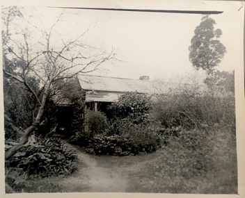
Photograph - 'Reno', St John's Parade, c.1960
This work forms part of the collection assembled by the historian Dorothy Rogers, that was donated to the Kew Historical Society by her son John Rogers in 2015. The manuscripts, photographs, maps, and documents were sourced by her from both family and local collections or produced as references for her print publications. Many were directly used by Rogers in writing ‘Lovely Old Homes of Kew’ (1961) and 'A History of Kew' (1973), or the numerous articles on local history that she produced for suburban newspapers. Most of the photographs in the collection include detailed annotations in her hand.The Rogers Collection provides a comprehensive insight into the working habits of a historian in the 1960s and 1970s. Together it forms the largest privately-donated collection within the archives of the Kew Historical Society.Small black and white photograph of 'Reno' (demolished 1977), St John's Parade, Kew."Reno / 3"historic houses -- kew (vic.), reno -- st john's parade -- kew (vic.) -
 Kew Historical Society Inc
Photograph - 'Reno', St John's Parade, c.1960
This work forms part of the collection assembled by the historian Dorothy Rogers, that was donated to the Kew Historical Society by her son John Rogers in 2015. The manuscripts, photographs, maps, and documents were sourced by her from both family and local collections or produced as references for her print publications. Many were directly used by Rogers in writing ‘Lovely Old Homes of Kew’ (1961) and 'A History of Kew' (1973), or the numerous articles on local history that she produced for suburban newspapers. Most of the photographs in the collection include detailed annotations in her hand.The Rogers Collection provides a comprehensive insight into the working habits of a historian in the 1960s and 1970s. Together it forms the largest privately-donated collection within the archives of the Kew Historical Society.Small black and white photograph of 'Reno' (demolished 1977), St John's Parade, Kew."49"historic houses -- kew (vic.), reno -- st john's parade -- kew (vic.) -
 Kew Historical Society Inc
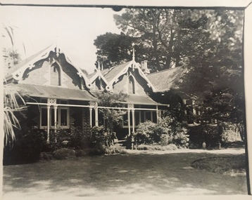
Photograph, 'Roseneath', Pakington Street, c.1960
This work forms part of the collection assembled by the historian Dorothy Rogers, that was donated to the Kew Historical Society by her son John Rogers in 2015. The manuscripts, photographs, maps, and documents were sourced by her from both family and local collections or produced as references for her print publications. Many were directly used by Rogers in writing ‘Lovely Old Homes of Kew’ (1961) and 'A History of Kew' (1973), or the numerous articles on local history that she produced for suburban newspapers. Most of the photographs in the collection include detailed annotations in her hand.The Rogers Collection provides a comprehensive insight into the working habits of a historian in the 1960s and 1970s. Together it forms the largest privately-donated collection within the archives of the Kew Historical Society.Small black and white photograph of 'Roseneath', Pakington Street, Kew."Roseneath. Ca.1858. North Wing added by E.J. Dunn"historic houses -- kew (vic.), roseneath -- pakington street -- kew(vic.) -
 Kew Historical Society Inc
Photograph, J E & B L Rogers, 'Swinton', Swinton Avenue, c.1959
This work forms part of the collection assembled by the historian Dorothy Rogers, that was donated to the Kew Historical Society by her son John Rogers in 2015. The manuscripts, photographs, maps, and documents were sourced by her from both family and local collections or produced as references for her print publications. Many were directly used by Rogers in writing ‘Lovely Old Homes of Kew’ (1961) and 'A History of Kew' (1973), or the numerous articles on local history that she produced for suburban newspapers. Most of the photographs in the collection include detailed annotations in her hand.The Rogers Collection provides a comprehensive insight into the working habits of a historian in the 1960s and 1970s. Together it forms the largest privately-donated collection within the archives of the Kew Historical Society.Small black and white photograph of 'Swinton', Swinton Avenue, Kew"SWINTON"swinton -- swinton avenue -- kew (vic.), historic houses -- kew (vic.) -
 Kew Historical Society Inc
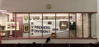
Photograph - Exhibition: Outdoor Leisure Activities: Lawn bowls, tennis and croquet [series], 2021
Following the acquisitions of the combined collections of the Kew Bowling Club, the Auburn Heights Recreation Club, and the Kew Heights Sports Club, the Kew Historical Society mounted exhibitions of selected items from these collections at the Kew Court House and Kew Library in March 2021.Series of born digital photos of exhibition at Kew Court House of 'Outdoor leisure activities: lawn bowls, tennis and croquet'. kew bowling club, auburn heights recreation club, auburn heights bowling club, auburn heights tennis club, kew heights bowling club, kew historical society -- exhibitions -
 Kew Historical Society Inc
Photograph - Outdoor Leisure Activities: Lawn bowls, tennis and croquet, 2021
Following the acquisitions of the combined collections of the Kew Bowling Club, the Auburn Heights Recreation Club, and the Kew Heights Sports Club, the Kew Historical Society mounted exhibitions of selected items from these collections at the Kew Court House and Kew Library in March 2021.Born digital photo of exhibition at Kew Library of 'Outdoor leisure activities: lawn bowls, tennis and croquet'. kew bowling club, auburn heights recreation club, auburn heights bowling club, auburn heights tennis club, kew heights bowling club, kew historical society -- exhibitions, kew library -
 Kew Historical Society Inc
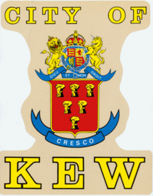
Sign, City of Kew Crest, 1975-1994
The seal of the former City of Kew is held in the collection of the City of Boroondara, as is the Mayoral Chain of Office. The original design was circular and cast in high relief to allow impressions to be made. Later versions such as this modernise the style for a range of purposes.Four colour version of the City of Kew Crest, adopted by the Municipality in 1861 for use in its circular seal but later adapted as in this version for printing or for identification. There are two examples this version: both transfers designed to be affixed to Council vehicles. The collection includes 11 copies of the large transfers and one copy of the smaller version. The bright colours used were typical of the period. The large version is 375 x 295 mm; the smaller is 205 x 155 mm.CITY OF KEW / DIEU ET MON DROITcity of kew, crests, municipal crests -
 Kew Historical Society Inc
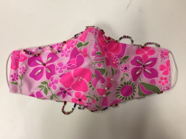
Accessory - Decorated Covid-19 Masks, 2020
... for the collection. masks covid-19 kew historical society -- celebrations ...The outbreak of Coronavirus COVID-19 in Melbourne in 2020 resulted in changed behaviours by the population. These changes included, at least in Kew, the placing of teddy bears in windows. In the final months of 2020, an easing of restrictions allowed members of the Kew Historical Society to meet face-to-face, including during the annual Christmas Dinner, on this occasion at the Greenacres Golf Club. At the event a decorated mask competition was held. Individual masks were donated by a number of attendees for the collection.A series of hand-made and adapted commercial masks worn during the COVID-19 pandemic in Melbourne at the annual Xmas Party of the Kew Historical Society. Attendees were advised that an award would be made to the creator/wearer of the best decorated mask. This was won by Jan Walker the owner of the pink patterned fabric beaded mask. The makers of each mask is identified in the Media Reuse credit underneath the image.masks, covid-19, kew historical society -- celebrations -
 Kew Historical Society Inc
Map, MMBW, MMBW Town of Kew, 1910-21
... Kew Historical Society Inc 1 Civic Drive Kew melbourne ...The Melbourne and Metropolitan Board of Works (MMBW) was established by an act of the Victorian Parliament in 1890 to prepare for and to implement a sewerage and water reticulation system across what was then inner Melbourne, its surrounding and middle distance suburbs, including Kew. The MMBW was disbanded in 1991.The map collection of the Kew Historical Society has at its core the historic maps assembled and originally stored in the City Engineer's Department of the City of Kew. These include maps in a number of scales. The vast majority of maps were produced by the MMBW in the first two decades of the twentieth century, and are solid working maps, backed by linen for durability. These maps are historically significant to Kew, the City of Boroondara and to the history of the development of state utilities in Victoria. A number of the Kew maps have additional details added by former municipal officers, including the levels reached by various floods. As these were working documents, information was added to them long after the period of their initial production and distribution.Early map of the Town of Kew, created after 1910, at a scale 440 ft to 1 inch. The 'assembled' map by the City of Kew Engineer's Department includes scaled down copies of The Melbourne and Metropolitan Board of Works maps, Nos. 39, 40, 64, 65, 66, 67, 68, and 117. The map covers the entirety of the Town of Kew, bordered on its north and west by the River Yarra, by Burke Road in the East and Barkers Road in the south. The map shows the extent of urban development by that time, prominent institutions and the outlines of built structures in the municipality. TOWN OF KEW / SCALE 400 FEET TO 1 INCHmelbourne & metropolitan board of works, mmbw maps, mmbw plans, town of kew, cartography -
 Kew Historical Society Inc
Map, MMBW, MMBW Plan No.39 Kew & Heidelberg, 1900-1910
... Kew Historical Society Inc 1 Civic Drive Kew melbourne ...The Melbourne and Metropolitan Board of Works (MMBW) was established by an act of the Victorian Parliament in 1890 to prepare for and to implement a sewerage and water reticulation system across what was then inner Melbourne, its surrounding and middle distance suburbs, including Kew. The MMBW was disbanded in 1991.The map collection of the Kew Historical Society has at its core the historic maps assembled and originally stored in the City Engineer's Department of the City of Kew. These include maps in a number of scales. The vast majority of maps were produced by the MMBW in the first two decades of the twentieth century, and are solid working maps, backed by linen for durability. These maps are historically significant to Kew, the City of Boroondara and to the history of the development of state utilities in Victoria. A number of the Kew maps have additional details added by former municipal officers, including the levels reached by various floods. As these were working documents, information was added to them long after the period of their initial production and distribution.Early map of part of the Borough of Kew, created in the first decade of the twentieth century, at a scale 160 ft to 1 inch. The map covers what was then the north western section of Kew, bordered on its north by Wills Street and the Kew Lunatic Asylum, in the west by the River Yarra [and the later added Yarra Boulevard] , by Princess Street in the East and Holroyd Street in the south. The map shows the extent of urban development by that time, prominent institutions and the outlines of built structures in the municipality. Contour lines were added in ink to the map at a later stage.MELBOURNE AND METROPOLITAN BOARD OF WORKS / PLAN NO. 39 / KEW & HEIDELBERGmelbourne & metropolitan board of works, mmbw maps, mmbw plans, borough of kew, cartography -
 Kew Historical Society Inc
Map, MMBW, MMBW Plan No.40 Collingwood & Kew, 1900-1910
... Kew Historical Society Inc 1 Civic Drive Kew melbourne ...The Melbourne and Metropolitan Board of Works (MMBW) was established by an act of the Victorian Parliament in 1890 to prepare for and to implement a sewerage and water reticulation system across what was then inner Melbourne, its surrounding and middle distance suburbs, including Kew. The MMBW was disbanded in 1991.The map collection of the Kew Historical Society has at its core the historic maps assembled and originally stored in the City Engineer's Department of the City of Kew. These include maps in a number of scales. The vast majority of maps were produced by the MMBW in the first two decades of the twentieth century, and are solid working maps, backed by linen for durability. These maps are historically significant to Kew, the City of Boroondara and to the history of the development of state utilities in Victoria. A number of the Kew maps have additional details added by former municipal officers, including the levels reached by various floods. As these were working documents, information was added to them long after the period of their initial production and distribution.Early map of part of the Borough of Kew, created in the first decade of the twentieth century, at a scale 160 ft to 1 inch. The map covers what was then the south western section of Kew, bordered on its north by Studley Park Road, in the west by Walmer Street and the River Yarra, by High Street South and Princess Street in the East and Barkers Road in the south. The map shows the extent of urban development by that time, prominent institutions and the outlines of built structures in the municipality. Contour lines and historic flood levels were added in ink to the map at a later stage.MELBOURNE AND METROPOLITAN BOARD OF WORKS / PLAN NO. 40 / COLLINGWOOD & KEWmelbourne & metropolitan board of works, mmbw maps, mmbw plans, borough of kew, cartography -
 Kew Historical Society Inc
Map, MMBW, MMBW Plan No.64 Kew & Heidelberg, 1900-1910
... Kew Historical Society Inc 1 Civic Drive Kew melbourne ...The Melbourne and Metropolitan Board of Works (MMBW) was established by an act of the Victorian Parliament in 1890 to prepare for and to implement a sewerage and water reticulation system across what was then inner Melbourne, its surrounding and middle distance suburbs, including Kew. The MMBW was disbanded in 1991.The map collection of the Kew Historical Society has at its core the historic maps assembled and originally stored in the City Engineer's Department of the City of Kew. These include maps in a number of scales. The vast majority of maps were produced by the MMBW in the first two decades of the twentieth century, and are solid working maps, backed by linen for durability. These maps are historically significant to Kew, the City of Boroondara and to the history of the development of state utilities in Victoria. A number of the Kew maps have additional details added by former municipal officers, including the levels reached by various floods. As these were working documents, information was added to them long after the period of their initial production and distribution.Early map of part of the Borough of Kew, created in the first decade of the twentieth century, at a scale 160 ft to 1 inch. The map covers what was then the northern most part of Kew, bordered on its north and west by the Yarra River, in the East by Connor's Creek and by the Asylum in the south. The map shows the extent of urban development by that time, prominent institutions and the outlines of built structures in the municipality. Contour lines and historic flood levels were added in ink to the map at a later stage.MELBOURNE AND METROPOLITAN BOARD OF WORKS / PLAN NO. 64 / KEW & HEIDELBERGmelbourne & metropolitan board of works, mmbw maps, mmbw plans, borough of kew, cartography -
 Kew Historical Society Inc
Map, MMBW, MMBW Plan No.65 Kew & Heidelberg, 1900-1910
... Kew Historical Society Inc 1 Civic Drive Kew melbourne ...The Melbourne and Metropolitan Board of Works (MMBW) was established by an act of the Victorian Parliament in 1890 to prepare for and to implement a sewerage and water reticulation system across what was then inner Melbourne, its surrounding and middle distance suburbs, including Kew. The MMBW was disbanded in 1991.The map collection of the Kew Historical Society has at its core the historic maps assembled and originally stored in the City Engineer's Department of the City of Kew. These include maps in a number of scales. The vast majority of maps were produced by the MMBW in the first two decades of the twentieth century, and are solid working maps, backed by linen for durability. These maps are historically significant to Kew, the City of Boroondara and to the history of the development of state utilities in Victoria. A number of the Kew maps have additional details added by former municipal officers, including the levels reached by various floods. As these were working documents, information was added to them long after the period of their initial production and distribution.Early map of part of the Borough of Kew, created in the first decade of the twentieth century, at a scale 160 ft to 1 inch. The map covers what was then the south central part of Kew, bordered on its north by Malmsbury Street, in the west by Florence Avenue, in the south by Barkers Road, and in the east by Princess Street. The map shows the extent of urban development by that time, prominent institutions and the outlines of built structures in the municipality. Contour lines were added in ink to the map at a later stage.MELBOURNE AND METROPOLITAN BOARD OF WORKS / PLAN NO. 65 / KEW & HEIDELBERGmelbourne & metropolitan board of works, mmbw maps, mmbw plans, borough of kew, cartography -
 Kew Historical Society Inc
Map, MMBW, MMBW Plan No.66 Kew, 1900-1910
... Kew Historical Society Inc 1 Civic Drive Kew melbourne ...The Melbourne and Metropolitan Board of Works (MMBW) was established by an act of the Victorian Parliament in 1890 to prepare for and to implement a sewerage and water reticulation system across what was then inner Melbourne, its surrounding and middle distance suburbs, including Kew. The MMBW was disbanded in 1991.The map collection of the Kew Historical Society has at its core the historic maps assembled and originally stored in the City Engineer's Department of the City of Kew. These include maps in a number of scales. The vast majority of maps were produced by the MMBW in the first two decades of the twentieth century, and are solid working maps, backed by linen for durability. These maps are historically significant to Kew, the City of Boroondara and to the history of the development of state utilities in Victoria. A number of the Kew maps have additional details added by former municipal officers, including the levels reached by various floods. As these were working documents, information was added to them long after the period of their initial production and distribution.Early map of part of the Borough of Kew, created in the first decade of the twentieth century, at a scale 160 ft to 1 inch. The map covers what was then the south eastern part of Kew, bordered on its north by Adeney Avenue, in the west by Sackville Street, in the south by Barkers Road, and in the east by Burke Road. The map shows the extent of urban development by that time, prominent institutions and the outlines of built structures in the municipality. Contour lines were added in ink to the map at a later stage.MELBOURNE AND METROPOLITAN BOARD OF WORKS / PLAN NO. 66 / KEW melbourne & metropolitan board of works, mmbw maps, mmbw plans, borough of kew, cartography -
 Kew Historical Society Inc
Map, MMBW, MMBW Plan No.67 Kew, 1900-1910
... Kew Historical Society Inc 1 Civic Drive Kew melbourne ...The Melbourne and Metropolitan Board of Works (MMBW) was established by an act of the Victorian Parliament in 1890 to prepare for and to implement a sewerage and water reticulation system across what was then inner Melbourne, its surrounding and middle distance suburbs, including Kew. The MMBW was disbanded in 1991.The map collection of the Kew Historical Society has at its core the historic maps assembled and originally stored in the City Engineer's Department of the City of Kew. These include maps in a number of scales. The vast majority of maps were produced by the MMBW in the first two decades of the twentieth century, and are solid working maps, backed by linen for durability. These maps are historically significant to Kew, the City of Boroondara and to the history of the development of state utilities in Victoria. A number of the Kew maps have additional details added by former municipal officers, including the levels reached by various floods. As these were working documents, information was added to them long after the period of their initial production and distribution.Early map of part of the Borough of Kew, created in the first decade of the twentieth century, at a scale 160 ft to 1 inch. The map covers what was then the north central part of Kew, bordered on its north by the Outer Circle Railway Spruzen and Beresford Avenues, in the west by Princess Street, in the south by High Street, and in the east by (about) Belford Road. The map shows the extent of urban development by that time, prominent institutions and the outlines of built structures in the municipality. Contour lines were added in ink to the map at a later stage.MELBOURNE AND METROPOLITAN BOARD OF WORKS / PLAN NO. 67 / KEW melbourne & metropolitan board of works, mmbw maps, mmbw plans, borough of kew, cartography -
 Kew Historical Society Inc
Map, MMBW, MMBW Plan No.68 Kew, 1900-1910
... Kew Historical Society Inc 1 Civic Drive Kew melbourne ...The Melbourne and Metropolitan Board of Works (MMBW) was established by an act of the Victorian Parliament in 1890 to prepare for and to implement a sewerage and water reticulation system across what was then inner Melbourne, its surrounding and middle distance suburbs, including Kew. The MMBW was disbanded in 1991.The map collection of the Kew Historical Society has at its core the historic maps assembled and originally stored in the City Engineer's Department of the City of Kew. These include maps in a number of scales. The vast majority of maps were produced by the MMBW in the first two decades of the twentieth century, and are solid working maps, backed by linen for durability. These maps are historically significant to Kew, the City of Boroondara and to the history of the development of state utilities in Victoria. A number of the Kew maps have additional details added by former municipal officers, including the levels reached by various floods. As these were working documents, information was added to them long after the period of their initial production and distribution.Early map of part of the Borough of Kew, created in the first decade of the twentieth century, at a scale 160 ft to 1 inch. The map covers what was then the north central part of Kew, bordered in the north by Oak Avenue, in the west by the Yarra River and Connor's Creek, in the south by Beresford and Carnegie Avenues, and in the east by Glass's Creek and Burke Road. The map shows the extent of urban development by that time, prominent institutions and the outlines of built structures in the municipality. Contour lines and the levels of historic floods were added in ink to the map at a later stage.MELBOURNE AND METROPOLITAN BOARD OF WORKS / PLAN NO. 68 / KEW melbourne & metropolitan board of works, mmbw maps, mmbw plans, borough of kew, cartography -
 Kew Historical Society Inc
Map, MMBW, MMBW Plan No.117 Heidelberg & Kew, 1900-1910
... Kew Historical Society Inc 1 Civic Drive Kew melbourne ...The Melbourne and Metropolitan Board of Works (MMBW) was established by an act of the Victorian Parliament in 1890 to prepare for and to implement a sewerage and water reticulation system across what was then inner Melbourne, its surrounding and middle distance suburbs, including Kew. The MMBW was disbanded in 1991.The map collection of the Kew Historical Society has at its core the historic maps assembled and originally stored in the City Engineer's Department of the City of Kew. These include maps in a number of scales. The vast majority of maps were produced by the MMBW in the first two decades of the twentieth century, and are solid working maps, backed by linen for durability. These maps are historically significant to Kew, the City of Boroondara and to the history of the development of state utilities in Victoria. A number of the Kew maps have additional details added by former municipal officers, including the levels reached by various floods. As these were working documents, information was added to them long after the period of their initial production and distribution.Early map of part of the Borough of Kew, created in the early twentieth century, at a scale 160 ft to 1 inch. The map covers what was then the north eastern part of Kew showing the natural landscape and limited development on the south side of the Yarra River. In the Kew section, south of the river, the land is occupied currently by the Greenacres and Kew Golf Clubs. The map shows the extent of urban development by that time and the outlines of the few built structures in the municipality. The height above sea level of all parts of the landscape are indicated numerically in feet. Contour lines and the levels of historic floods were added in ink to the map at a later stage. MELBOURNE AND METROPOLITAN BOARD OF WORKS / PLAN NO. 117 / HEIDELBERG & KEW melbourne & metropolitan board of works, mmbw maps, borough of kew, cartography, mmbw plan no. 117, kew (vic.) -- maps, heidelberg (vic.) -- maps -
 Kew Historical Society Inc
Map, MMBW, River Yarra Beautification Schemes, c.1913
... Kew Historical Society Inc 1 Civic Drive Kew melbourne ...The Melbourne and Metropolitan Board of Works (MMBW) was established by an act of the Victorian Parliament in 1890 to prepare for and to implement a sewerage and water reticulation system across what was then inner Melbourne, its surrounding and middle distance suburbs, including Kew. The MMBW was disbanded in 1991.The map collection of the Kew Historical Society has at its core the historic maps assembled and originally stored in the City Engineer's Department of the City of Kew. These include maps in a number of scales. The vast majority of maps were produced by the MMBW in the first two decades of the twentieth century, and are solid working maps, backed by linen for durability. These maps are historically significant to Kew, the City of Boroondara and to the history of the development of state utilities in Victoria. A number of the Kew maps have additional details added by former municipal officers, including the levels reached by various floods. As these were working documents, information was added to them long after the period of their initial production and distribution.Map of the City of Kew showing part of the River Yarra Beautification Schemes. The map shows development to date and the flood levels reached in 1923 and 1924. This map may have been adapted from an earlier map, as most development in central Kew and Studley Park had occurred by this date yet numerous streets are not represented. Public buildings and institutions are clearly represented and named on the map as are significant public transport infrastructure (eg the Outer Circle railway).MELBOURNE AND METROPOLITAN BOARD OF WORKS / RIVER YARRA BEAUTIFICATION SCHEMES / SCHEME / SCALE 10 CHAINS TO AN INCHmelbourne & metropolitan board of works, mmbw maps, mmbw plans, city of kew, flood levels -- kew (vic.), cartography -
 Kew Historical Society Inc
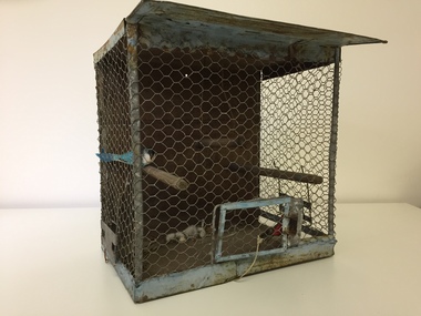
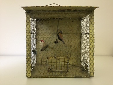
Functional object - Bird cage, 1930s
One of a collection of Depression-era items donated by Mrs Elizabeth Angel. The cage, and another similar cage is constructed of found or recycled materials including what appear to be kerosone tinsDepression-era handmade birdcage, constructed out of painted tin and chicken wire. The cage has an overhanging piece of iron at the front for protection from the weather. It is open on three sides. bird cages -
 Kew Historical Society Inc
Functional object - Bird cage, 1930s
One of a collection of Depression-era items donated by Mrs Elizabeth Angel. The cage, and another similar cage, is constructed of found or recycled materials including what appear to be kerosene tinsDepression-era handmade birdcage, constructed out of painted tin and chicken wire. The cage has an overhanging piece of iron at the front for protection from the weather. It is open on three sides. bird cages -
 Kew Historical Society Inc
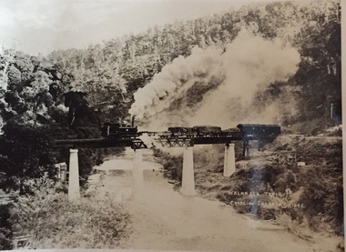
Postcard, Walhalla Train Crossing Thomson Bridge, c.1910
One of a number of 'real photo' and commercial postcards created by or owned by members of the Christian and Washfold families of Kew. The postcards are part of a larger collection of photographs, postcards and publications donated to the collection in May 2021.Small black and white 'real postcard' of the Walhalla Train crossing the Thomson Bridge.Walhalla Train Crossing Thomson Bridgehenry christian (1886-1962), landscape photography, thomson river (vic.), thomson bridge (vic.), trains -- walhalla -- victoria, christian-washfold collection -
 Kew Historical Society Inc
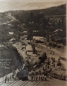
Postcard, M. Lee, First Train to Walhalla 15.3.1910, 1910
One of a number of 'real photo' and commercial postcards created by or owned by members of the Christian and Washfold families of Kew. The postcards are part of a larger collection of photographs, postcards and publications donated to the collection in May 2021.Small black and white postcard of the first train to Walhalla arriving in the township on 15 March 1910.First Train to Walhalla 15.3.1910. M. Lee Photohenry christian (1886-1962), landscape photography, trains -- walhalla -- victoria, christian-washfold collection -
 Kew Historical Society Inc
Postcard - Flood, Glenferrie Road, 1921
An item from an outstanding and diverse photographic and postcard collection, assembled by members of the Christian and Washfold families of Kew.Flood waters in Glenferrie Road. Glenferrie Meat Supply – Boyd & Winnett opposite. Car in distance in flood waters. Real photo postcard. Kodak print.glenferrie road -- hawthorn (vic.), floods -- hawthorn (vic.), christian-washfold collection -
 Kew Historical Society Inc
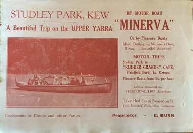
Flyer, A beautiful trip on the Upper Yarra on the motor boat 'Minerva', 1930s
An item of ephemera relating to tourism and recreation on the Yarra River in Melbourne in the first half of the twentieth century.An item from a large collection assembled by the Christian and Washfold families of Kew, including photographs, postcards, and ephemera. Many of the items in the Christian-Washfold Collection relate to the Yarra River and its use as as a recreational resource. Numerous items in the collection are historically important in that they are rare and often unique records of vanished locations or past recreational activities.Flyer for a ‘beautiful trip on the Upper Yarra on the motor boat ‘Minerva’. The proprietor is named as E. Burn. There is a picture of the Minerva with passengers on the front and an advertisement for Woodrow’s Hats on the reverse. christian-washfold collection, river yarra -- recreation, yarra -- boat trips, motor boat -- minerva -
 Kew Historical Society Inc
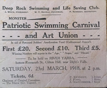
Flyer, Deep Rock Swimming and Lifesaving Club, Monster Patriotic Swimming Carnival and Art Union, 1918
An item of ephemera relating to tourism and recreation on the Yarra River in Melbourne in the first half of the twentieth century.An item from a large collection assembled by the Christian and Washfold families of Kew, including photographs, postcards, and ephemera. Many of the items in the Christian-Washfold Collection relate to the Yarra River and its use as as a recreational resource. Numerous items in the collection are historically important in that they are rare and often unique records of vanished locations or past recreational activities.Advertisement or ticket to a Monster Swimming Carnival to be held by the Deep Rock Swimming and Lifesaving Club in Fairfield at the bottom of Roseneath Street on Saturday 23rd March 1918 at 2 p.m.christian-washfold collection, river yarra -- recreation, yarra - swimming carnivals, deep rock pool -
 Kew Historical Society Inc
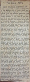
Newspaper - Article, The Upper Yarra: boat traffic endangered, 1918-20
An item of ephemera relating to tourism and recreation on the Yarra River in Melbourne in the first half of the twentieth century.An item from a large collection assembled by the Christian and Washfold families of Kew, including photographs, postcards, and ephemera. Many of the items in the Christian-Washfold Collection relate to the Yarra River and its use as as a recreational resource. Numerous items in the collection are historically important in that they are rare and often unique records of vanished locations or past recreational activities.Article describing the effects of the partial collapse of the weir at Dight’s Falls and its impact on water levels between Kew, Fairfield, and Heidelberg. The article is undated however as it describes Cr Harry Tompkins as Mayor of Kew it must date to the years 1918-20.christian-washfold collection, river yarra -- recreation, dight's falls