Showing 8062 items
matching 1890-1969
-
 Orbost & District Historical Society
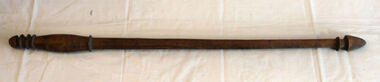
hunting stick
Inspected by Joanna Freslov, archaeologist 2.6.2008. This club was brought from New Hebrides to Orbost by Reverend Alex Morton in 1894. Morton was the minister at the Presbyterian church about 1890. He had spent time in new Hebrides and went on to New Zealand.A handmade carved wooden club with carved rings at top and bottom.weapon new-hebrides hunting-club morton -
 Warrnambool and District Historical Society Inc.
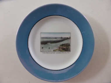
Souvenir plate, The breakwater, Mid 20th century
This item has been bought as a souvenir of Warrnambool probably by a tourist. It features the breakwater built in 1890 to assist shipping in the port of Warrnambool . Tourism is important in Warrnambool today - in Summer the coastal scenery and the beaches and in Winter the with the whale season and the May Racing Carnival This item is of minor interest as an example of a tourist souvenir of Warrnambool.Small circular plate with pale blue border with interior black ring. The centre of the plate is white and has a rectangular image of the breakwater.The breakwater Warrnambool Vic is in black text underneath the image. Noritake made in Japan in green on back of the platewarrnamool breakwater -
 Stawell Historical Society Inc
Archive, Presbyterian Church Committee Meeting Minute Book 1860 - 1901, 1860 - 1901
Used by Commitee of Presbyterian Church Meeting Minutes 2-4-1860 to 24-6-1901 Also Members of Committee listed for Years 1891, 1892, 1893, 1894, 1895 Also Collectors Listed for Years 1873 Through to June 1890Black Cover with Gold Writingstawell, religion -
 Kew Historical Society Inc
Map, MMBW, MMBW Town of Kew, 1910-21
The Melbourne and Metropolitan Board of Works (MMBW) was established by an act of the Victorian Parliament in 1890 to prepare for and to implement a sewerage and water reticulation system across what was then inner Melbourne, its surrounding and middle distance suburbs, including Kew. The MMBW was disbanded in 1991.The map collection of the Kew Historical Society has at its core the historic maps assembled and originally stored in the City Engineer's Department of the City of Kew. These include maps in a number of scales. The vast majority of maps were produced by the MMBW in the first two decades of the twentieth century, and are solid working maps, backed by linen for durability. These maps are historically significant to Kew, the City of Boroondara and to the history of the development of state utilities in Victoria. A number of the Kew maps have additional details added by former municipal officers, including the levels reached by various floods. As these were working documents, information was added to them long after the period of their initial production and distribution.Early map of the Town of Kew, created after 1910, at a scale 440 ft to 1 inch. The 'assembled' map by the City of Kew Engineer's Department includes scaled down copies of The Melbourne and Metropolitan Board of Works maps, Nos. 39, 40, 64, 65, 66, 67, 68, and 117. The map covers the entirety of the Town of Kew, bordered on its north and west by the River Yarra, by Burke Road in the East and Barkers Road in the south. The map shows the extent of urban development by that time, prominent institutions and the outlines of built structures in the municipality. TOWN OF KEW / SCALE 400 FEET TO 1 INCHmelbourne & metropolitan board of works, mmbw maps, mmbw plans, town of kew, cartography -
 Kew Historical Society Inc
Map, MMBW, MMBW Plan No.39 Kew & Heidelberg, 1900-1910
The Melbourne and Metropolitan Board of Works (MMBW) was established by an act of the Victorian Parliament in 1890 to prepare for and to implement a sewerage and water reticulation system across what was then inner Melbourne, its surrounding and middle distance suburbs, including Kew. The MMBW was disbanded in 1991.The map collection of the Kew Historical Society has at its core the historic maps assembled and originally stored in the City Engineer's Department of the City of Kew. These include maps in a number of scales. The vast majority of maps were produced by the MMBW in the first two decades of the twentieth century, and are solid working maps, backed by linen for durability. These maps are historically significant to Kew, the City of Boroondara and to the history of the development of state utilities in Victoria. A number of the Kew maps have additional details added by former municipal officers, including the levels reached by various floods. As these were working documents, information was added to them long after the period of their initial production and distribution.Early map of part of the Borough of Kew, created in the first decade of the twentieth century, at a scale 160 ft to 1 inch. The map covers what was then the north western section of Kew, bordered on its north by Wills Street and the Kew Lunatic Asylum, in the west by the River Yarra [and the later added Yarra Boulevard] , by Princess Street in the East and Holroyd Street in the south. The map shows the extent of urban development by that time, prominent institutions and the outlines of built structures in the municipality. Contour lines were added in ink to the map at a later stage.MELBOURNE AND METROPOLITAN BOARD OF WORKS / PLAN NO. 39 / KEW & HEIDELBERGmelbourne & metropolitan board of works, mmbw maps, mmbw plans, borough of kew, cartography -
 Kew Historical Society Inc
Map, MMBW, MMBW Plan No.40 Collingwood & Kew, 1900-1910
The Melbourne and Metropolitan Board of Works (MMBW) was established by an act of the Victorian Parliament in 1890 to prepare for and to implement a sewerage and water reticulation system across what was then inner Melbourne, its surrounding and middle distance suburbs, including Kew. The MMBW was disbanded in 1991.The map collection of the Kew Historical Society has at its core the historic maps assembled and originally stored in the City Engineer's Department of the City of Kew. These include maps in a number of scales. The vast majority of maps were produced by the MMBW in the first two decades of the twentieth century, and are solid working maps, backed by linen for durability. These maps are historically significant to Kew, the City of Boroondara and to the history of the development of state utilities in Victoria. A number of the Kew maps have additional details added by former municipal officers, including the levels reached by various floods. As these were working documents, information was added to them long after the period of their initial production and distribution.Early map of part of the Borough of Kew, created in the first decade of the twentieth century, at a scale 160 ft to 1 inch. The map covers what was then the south western section of Kew, bordered on its north by Studley Park Road, in the west by Walmer Street and the River Yarra, by High Street South and Princess Street in the East and Barkers Road in the south. The map shows the extent of urban development by that time, prominent institutions and the outlines of built structures in the municipality. Contour lines and historic flood levels were added in ink to the map at a later stage.MELBOURNE AND METROPOLITAN BOARD OF WORKS / PLAN NO. 40 / COLLINGWOOD & KEWmelbourne & metropolitan board of works, mmbw maps, mmbw plans, borough of kew, cartography -
 Kew Historical Society Inc
Map, MMBW, MMBW Plan No.64 Kew & Heidelberg, 1900-1910
The Melbourne and Metropolitan Board of Works (MMBW) was established by an act of the Victorian Parliament in 1890 to prepare for and to implement a sewerage and water reticulation system across what was then inner Melbourne, its surrounding and middle distance suburbs, including Kew. The MMBW was disbanded in 1991.The map collection of the Kew Historical Society has at its core the historic maps assembled and originally stored in the City Engineer's Department of the City of Kew. These include maps in a number of scales. The vast majority of maps were produced by the MMBW in the first two decades of the twentieth century, and are solid working maps, backed by linen for durability. These maps are historically significant to Kew, the City of Boroondara and to the history of the development of state utilities in Victoria. A number of the Kew maps have additional details added by former municipal officers, including the levels reached by various floods. As these were working documents, information was added to them long after the period of their initial production and distribution.Early map of part of the Borough of Kew, created in the first decade of the twentieth century, at a scale 160 ft to 1 inch. The map covers what was then the northern most part of Kew, bordered on its north and west by the Yarra River, in the East by Connor's Creek and by the Asylum in the south. The map shows the extent of urban development by that time, prominent institutions and the outlines of built structures in the municipality. Contour lines and historic flood levels were added in ink to the map at a later stage.MELBOURNE AND METROPOLITAN BOARD OF WORKS / PLAN NO. 64 / KEW & HEIDELBERGmelbourne & metropolitan board of works, mmbw maps, mmbw plans, borough of kew, cartography -
 Kew Historical Society Inc
Map, MMBW, MMBW Plan No.65 Kew & Heidelberg, 1900-1910
The Melbourne and Metropolitan Board of Works (MMBW) was established by an act of the Victorian Parliament in 1890 to prepare for and to implement a sewerage and water reticulation system across what was then inner Melbourne, its surrounding and middle distance suburbs, including Kew. The MMBW was disbanded in 1991.The map collection of the Kew Historical Society has at its core the historic maps assembled and originally stored in the City Engineer's Department of the City of Kew. These include maps in a number of scales. The vast majority of maps were produced by the MMBW in the first two decades of the twentieth century, and are solid working maps, backed by linen for durability. These maps are historically significant to Kew, the City of Boroondara and to the history of the development of state utilities in Victoria. A number of the Kew maps have additional details added by former municipal officers, including the levels reached by various floods. As these were working documents, information was added to them long after the period of their initial production and distribution.Early map of part of the Borough of Kew, created in the first decade of the twentieth century, at a scale 160 ft to 1 inch. The map covers what was then the south central part of Kew, bordered on its north by Malmsbury Street, in the west by Florence Avenue, in the south by Barkers Road, and in the east by Princess Street. The map shows the extent of urban development by that time, prominent institutions and the outlines of built structures in the municipality. Contour lines were added in ink to the map at a later stage.MELBOURNE AND METROPOLITAN BOARD OF WORKS / PLAN NO. 65 / KEW & HEIDELBERGmelbourne & metropolitan board of works, mmbw maps, mmbw plans, borough of kew, cartography -
 Kew Historical Society Inc
Map, MMBW, MMBW Plan No.66 Kew, 1900-1910
The Melbourne and Metropolitan Board of Works (MMBW) was established by an act of the Victorian Parliament in 1890 to prepare for and to implement a sewerage and water reticulation system across what was then inner Melbourne, its surrounding and middle distance suburbs, including Kew. The MMBW was disbanded in 1991.The map collection of the Kew Historical Society has at its core the historic maps assembled and originally stored in the City Engineer's Department of the City of Kew. These include maps in a number of scales. The vast majority of maps were produced by the MMBW in the first two decades of the twentieth century, and are solid working maps, backed by linen for durability. These maps are historically significant to Kew, the City of Boroondara and to the history of the development of state utilities in Victoria. A number of the Kew maps have additional details added by former municipal officers, including the levels reached by various floods. As these were working documents, information was added to them long after the period of their initial production and distribution.Early map of part of the Borough of Kew, created in the first decade of the twentieth century, at a scale 160 ft to 1 inch. The map covers what was then the south eastern part of Kew, bordered on its north by Adeney Avenue, in the west by Sackville Street, in the south by Barkers Road, and in the east by Burke Road. The map shows the extent of urban development by that time, prominent institutions and the outlines of built structures in the municipality. Contour lines were added in ink to the map at a later stage.MELBOURNE AND METROPOLITAN BOARD OF WORKS / PLAN NO. 66 / KEW melbourne & metropolitan board of works, mmbw maps, mmbw plans, borough of kew, cartography -
 Kew Historical Society Inc
Map, MMBW, MMBW Plan No.67 Kew, 1900-1910
The Melbourne and Metropolitan Board of Works (MMBW) was established by an act of the Victorian Parliament in 1890 to prepare for and to implement a sewerage and water reticulation system across what was then inner Melbourne, its surrounding and middle distance suburbs, including Kew. The MMBW was disbanded in 1991.The map collection of the Kew Historical Society has at its core the historic maps assembled and originally stored in the City Engineer's Department of the City of Kew. These include maps in a number of scales. The vast majority of maps were produced by the MMBW in the first two decades of the twentieth century, and are solid working maps, backed by linen for durability. These maps are historically significant to Kew, the City of Boroondara and to the history of the development of state utilities in Victoria. A number of the Kew maps have additional details added by former municipal officers, including the levels reached by various floods. As these were working documents, information was added to them long after the period of their initial production and distribution.Early map of part of the Borough of Kew, created in the first decade of the twentieth century, at a scale 160 ft to 1 inch. The map covers what was then the north central part of Kew, bordered on its north by the Outer Circle Railway Spruzen and Beresford Avenues, in the west by Princess Street, in the south by High Street, and in the east by (about) Belford Road. The map shows the extent of urban development by that time, prominent institutions and the outlines of built structures in the municipality. Contour lines were added in ink to the map at a later stage.MELBOURNE AND METROPOLITAN BOARD OF WORKS / PLAN NO. 67 / KEW melbourne & metropolitan board of works, mmbw maps, mmbw plans, borough of kew, cartography -
 Kew Historical Society Inc
Map, MMBW, MMBW Plan No.68 Kew, 1900-1910
The Melbourne and Metropolitan Board of Works (MMBW) was established by an act of the Victorian Parliament in 1890 to prepare for and to implement a sewerage and water reticulation system across what was then inner Melbourne, its surrounding and middle distance suburbs, including Kew. The MMBW was disbanded in 1991.The map collection of the Kew Historical Society has at its core the historic maps assembled and originally stored in the City Engineer's Department of the City of Kew. These include maps in a number of scales. The vast majority of maps were produced by the MMBW in the first two decades of the twentieth century, and are solid working maps, backed by linen for durability. These maps are historically significant to Kew, the City of Boroondara and to the history of the development of state utilities in Victoria. A number of the Kew maps have additional details added by former municipal officers, including the levels reached by various floods. As these were working documents, information was added to them long after the period of their initial production and distribution.Early map of part of the Borough of Kew, created in the first decade of the twentieth century, at a scale 160 ft to 1 inch. The map covers what was then the north central part of Kew, bordered in the north by Oak Avenue, in the west by the Yarra River and Connor's Creek, in the south by Beresford and Carnegie Avenues, and in the east by Glass's Creek and Burke Road. The map shows the extent of urban development by that time, prominent institutions and the outlines of built structures in the municipality. Contour lines and the levels of historic floods were added in ink to the map at a later stage.MELBOURNE AND METROPOLITAN BOARD OF WORKS / PLAN NO. 68 / KEW melbourne & metropolitan board of works, mmbw maps, mmbw plans, borough of kew, cartography -
 Kew Historical Society Inc
Map, MMBW, MMBW Plan No.117 Heidelberg & Kew, 1900-1910
The Melbourne and Metropolitan Board of Works (MMBW) was established by an act of the Victorian Parliament in 1890 to prepare for and to implement a sewerage and water reticulation system across what was then inner Melbourne, its surrounding and middle distance suburbs, including Kew. The MMBW was disbanded in 1991.The map collection of the Kew Historical Society has at its core the historic maps assembled and originally stored in the City Engineer's Department of the City of Kew. These include maps in a number of scales. The vast majority of maps were produced by the MMBW in the first two decades of the twentieth century, and are solid working maps, backed by linen for durability. These maps are historically significant to Kew, the City of Boroondara and to the history of the development of state utilities in Victoria. A number of the Kew maps have additional details added by former municipal officers, including the levels reached by various floods. As these were working documents, information was added to them long after the period of their initial production and distribution.Early map of part of the Borough of Kew, created in the early twentieth century, at a scale 160 ft to 1 inch. The map covers what was then the north eastern part of Kew showing the natural landscape and limited development on the south side of the Yarra River. In the Kew section, south of the river, the land is occupied currently by the Greenacres and Kew Golf Clubs. The map shows the extent of urban development by that time and the outlines of the few built structures in the municipality. The height above sea level of all parts of the landscape are indicated numerically in feet. Contour lines and the levels of historic floods were added in ink to the map at a later stage. MELBOURNE AND METROPOLITAN BOARD OF WORKS / PLAN NO. 117 / HEIDELBERG & KEW melbourne & metropolitan board of works, mmbw maps, borough of kew, cartography, mmbw plan no. 117, kew (vic.) -- maps, heidelberg (vic.) -- maps -
 Kew Historical Society Inc
Map, MMBW, River Yarra Beautification Schemes, c.1913
The Melbourne and Metropolitan Board of Works (MMBW) was established by an act of the Victorian Parliament in 1890 to prepare for and to implement a sewerage and water reticulation system across what was then inner Melbourne, its surrounding and middle distance suburbs, including Kew. The MMBW was disbanded in 1991.The map collection of the Kew Historical Society has at its core the historic maps assembled and originally stored in the City Engineer's Department of the City of Kew. These include maps in a number of scales. The vast majority of maps were produced by the MMBW in the first two decades of the twentieth century, and are solid working maps, backed by linen for durability. These maps are historically significant to Kew, the City of Boroondara and to the history of the development of state utilities in Victoria. A number of the Kew maps have additional details added by former municipal officers, including the levels reached by various floods. As these were working documents, information was added to them long after the period of their initial production and distribution.Map of the City of Kew showing part of the River Yarra Beautification Schemes. The map shows development to date and the flood levels reached in 1923 and 1924. This map may have been adapted from an earlier map, as most development in central Kew and Studley Park had occurred by this date yet numerous streets are not represented. Public buildings and institutions are clearly represented and named on the map as are significant public transport infrastructure (eg the Outer Circle railway).MELBOURNE AND METROPOLITAN BOARD OF WORKS / RIVER YARRA BEAUTIFICATION SCHEMES / SCHEME / SCALE 10 CHAINS TO AN INCHmelbourne & metropolitan board of works, mmbw maps, mmbw plans, city of kew, flood levels -- kew (vic.), cartography -
Glenelg Shire Council Cultural Collection
Photograph - Photograph - Portland Gaol, n.d
The Gaol at Portland was in operation as early as 1852. It was reproclaimed in the Government Gazette, along with several other prisons in the colony, in October 1877. In 1892, it was proclaimed a Police Gaol, under the provisions of the Gaols Act 1890. The Police Gaol was closed by proclamation in March 1893.Black and white photo of gaol at Portland, two sides visible. High stone walls, roof of building visible behind walls. Large stone pillars either side of wooden entrance. Dilapidated wooden fence, cow grazing in foreground.Front: 'THE FIRST JAIL IN VICTORIA, PORTLAND' - white print on bottom edge of photoportland gaol, jail, incarceration, prison -
 St Kilda Historical Society
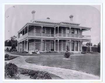
Photograph, Donald McDonald, Yanakie St Kilda, 1872
Built for William Wilmot Couche (1829-1890) probably in 1869. The architect was Lloyd Tayler (1830-1900) and it was designed in the polychromatic Lombardic style that had been introduced to Melbourne by the architect Joseph Reed (1822-1890). Couch was a prominent merchant and businessman. He founded the firm Couch Calder & Co, was director of several insurance companies and a member of the Melbourne Harbour Trust for many years. From about 1900 the house was renamed Wavenhoe. In the 1920s Wavenoe Avenue was constructed through its gardens and most of the land sold off including the blocks at the corner of Hotham Street and Alma Road. The house still stands opposite St Kilda cemetery.black and white photograph copy -
 Eltham District Historical Society Inc
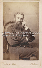
Photograph, Ezra Goulter, Unidentified Shillinglaw Family Male, c.1885
Photographer Ezra Goulter operated from 23 Chapel St. Prahran between 1878-1890 A duplicate photo is contained in Album 2 (05664) CARTE-DE-VISITE (cdv) 1857-1890 Cartes-de-visite (cdv's) are the most common form of photograph from the nineteenth century, generally measuring two and a half inches by four and an eighth inches (6.3 x 10.5 cm) when mounted, sepia toned, mounted on a card which was generally printed with the photographer's name and address on the back or beneath the portrait. - Frost, Lenore; Dating Family Photos 1850-1920; Valiant Press Pty. Ltd., Berwick, Victoria 1991marg ball collection, shillinglaw family photo album 1, 1878-1890, goulter photographer chapel st prahan, male shillinglaw 7, unknown, 1885 -
Clunes Museum
Document - APPLICATION FOR MINING RIGHTS
.1 NOTICE TO OWNER OR OCCUPIER UNDER THE MINES ACT. HENRY PEACOCK APPLIED TO MINING RIGHTS ON LAND AT LORD CLYDE OWNED BY LACHLAN MCLENNAN.DATED 1897 .2 COVERING LETTER FROM H, PEACOCK TO L MCLENNAN DATED 21 AUGUST 1897 .3 AGREEMENT UNDER THE MINES ACT 1890 DATED 16 AUGUST 1897 (2 COPIES) BETWEEN H PEACOCK AND L MCLENNANhenry peacock, lachlan mclennan -
 Bendigo Historical Society Inc.
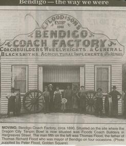
Newspaper - JENNY FOLEY COLLECTION: MOVING, 2000
Bendigo Advertiser ''The way we were'' from 2000. Moving: Bendigo Coach Factory circa 1890. Situated on the site where the Dragon City Tenpin Bowl is now situated was Floods Coach Builders in Hargreaves street. The man fifth on the left was Thomas Flood, the father of Thomas Richard Flood who was mayor of Bendigo on four occasions. (Photo supplied by Peter Flood, Golden Square). The clip is a folder.newspaper, bendigo advertiser, the way we were -
 Bendigo Historical Society Inc.
Document - ALEC H CHISHOLM COLLECTION: BOOK - BRIEF BIOGRAPHY OF ALEXANDER HUGH CHISHOLM
DOCUMENT - ALEC H CHISHOLM COLLECTION. Copy from the Australian Dictionary of Biography on the career of Alexander Hugh (Alec) Chisholm, 1890 - 1977. by Tess Kloot. Handwritten obituary notice from the Sydney Morning Herald 15 July 1977. Reference made to his daughter Deirdre Chisholm of Bendigo. The ALEC H CHISHOLM COLLECTION of books would have been donated to the Historical Society by her.Rob Upsondocument, memo, alec h chisholm, alec h chisholm collection, biography, deirdre chisholm -
 Bendigo Historical Society Inc.
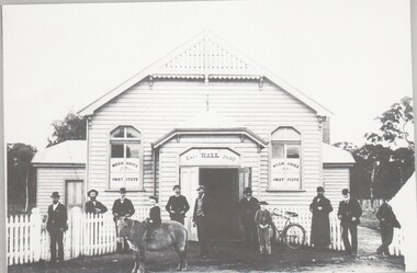
Photograph - HARRY BIGGS COLLECTION: MECHANICS INSTITUTE, C1900
Photograph (proof 29) A timber hall with the words 'Mechanics Institute' written on two windows either side of a wide doorway, above the doorway are the words 'Hall Est. 1890'. There are a group of nine adult males and two boys in front of the building. One of the boys is seated on a pony. There is a white picket fence running at an angle from either side of the doorway, there is a bicycle leaning against the right hand side fencebuildings, organisation, mechanics institute, mechanics institute -
 Bendigo Military Museum
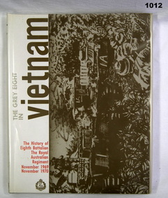
Book, The Grey Eight in Vietnam, 1989
Illustrated history of the 8th Battalian RAR in Vietnam 1969-70 with index of awards and nominal rollHard cover, green buckram. Dust cover paper and plastic cover. Brown/grey print (illustration). White background, red print. Pages 160 IllustratedInside cover "PETER BALL"book, military history, vietnam -
National Wool Museum
Book, Labour inspection in agriculture
"Labour inspection in agriculture" -Provisional records, International Labour Conference, 53rd session, Geneva, 1969.agriculture - industrial relations labour movement - australia shearing sheep stations - management stockmen, international labour organization, agriculture - industrial relations, labour movement - australia, shearing, sheep stations - management, stockmen -
 City of Moorabbin Historical Society (Operating the Box Cottage Museum)
Photograph - 115 Jasper Road, Bentleigh, Allan / Grewer Estate, c. 1890's
115 Jasper Road, Bentleigh East was a market garden owned by James Allan. In 1880 the property was transferred to David Grewar (Gruar) who had married James' niece Mary Allan. In 1926 part of the land was subdivided and sold as residential blocks. The block with the house pictured remained in the family until 1969. The land now forms part of Our Lady of Sacred Heart College. The description of the land owned by David Kidd Grewer (also spelt Gruar) in 1885: Fourteen acres or thereabouts at the corner of Jasper Road and Patterson’s Road East Brighton being part of Crown Block of 5720 acres Parish of Moorabbin County of Bourke being land comprised in Certificate of Title Volume 1344 Folio 268692 on which is erected a 4 roomed brick house with 2 rooms of wood at the rear and stable and a 2 roomed weatherboard cottage valued as under: 14 acres of land less crops £629.0.0 4 roomed brick house £250.0.0 Other buildings £50.0.0 2 roomed weatherboard cottage £35.0.0 Early pioneer family of the City of Moorabbin.Black and White photo in picture framegrewar, market garden, moorabbin, bentleigh, jasper road, housing, pioneer, james allan, orchard -
Moorabbin Air Museum
Manual (Item) - Cessna Manuals Various see "Description"
-
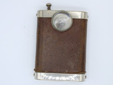 Ararat & District Historical Society (operating the Langi Morgala Museum)
Tool - Nurses Lamp
The lamp helps contextualise the nursing history of our region. This item was owned by Sister Hebe Graham, who was born in 1890 and trained at Stawell Hospital before WW1. She became a specialist nurse and received a commendation from Lord Duggan, Governor of Victoria.Flat, rectangular lamp with light fixed at top centre and activated by small spring-loaded button on top of lamp. Case is primarily stainless steel and partially covered in a leather case."T E C BRITISH MADE" stamped on top of lamp.sister hebe graham, nurses lamp, stawell hospital, ww1, 1890, lord duggan -
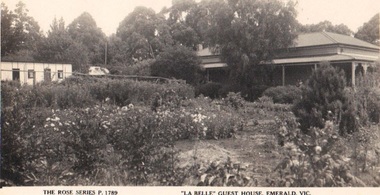 Emerald Museum & Nobelius Heritage Park
Photograph/postcard, 'La Belle' Guest House, Emerald, Vic, c 1940's
Tim Kennedy built 'La Belle' Guest House circa 1890 - 1920. It became 'The Grange' sometime after 1942. The guest house was on Belgrave/Gembrook Road between IGA and the Shell Petrol Station. Unfortunately the guest house was demolished around 1983.Guest houses of the DandenongsSepia postcard, Rose Series depicting early guest house in EmeraldFront: The Rose Series Postcard, 'La Belle' Guest House, Emerald Vic. Back:: (handwritten) Dear Miss Hartnell, Just to wish you a Happy Xmas and bright new year I hope and trust that your health is better it was just twelve months yesterday since I returned from Olinda how time flies Doesent it, with all good wishes yours sincerely B George'la belle', the grange, tim kennedy -
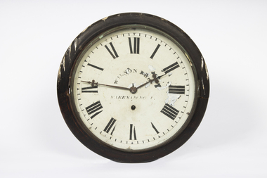 Warrnambool and District Historical Society Inc.
Functional object - Railway Clock, Wilson Brothers, Clock Makers, Warrnambool, 1890s
This clock is believed to have come from the Warrnambool Railway Station. The Railway commenced in 1890 and the station was opened in 1897. The clock was made by Wilson Brothers, a prominent manufacturing watch and clock- making business in Timor Street, Warrnambool in the second half of the 19th Century.This item is of considerable significance as an early Railway Clock in Warrnambool. Railway Clocks were important in the 19th century as prominent time pieces for the general community to use to establish the time of day.This is a clock with a circular face behind glass enclosed in a metal frame with wood surrounds The wooden frame is attached to a wooden rectangular box with a curved bottom. The box has a metal clip for attachment to a wall or a board. The metal face is white with black painted Roman numerals, which are damaged, and black printing. Minute markers are indicated. The hands are metal. All the metal is rusted.Wilson Bros Warrnamboolwarrnambool railway station, wilson brothers warrnambool -
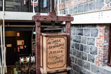 National Wool Museum
Wool Press
Built by Humble & Nicholson at the Vulcan Foundry, Geelong, press no. 804. Was sold to the Shanahans of Happy Valley, Birregurra on 18/10/1890 and remained on the property until the late 1960s/early 1970s when it was donated to the Geelong Agricultural society who donated in to the Museum.humble and nicholson, wool press, happy valley, birregurra, vic. -
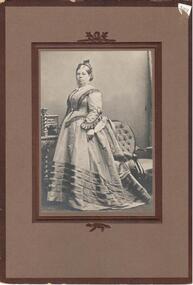 Hume City Civic Collection
Photograph, c1880
Ann Holden married George Evans at the age of 16 in 1843. She lived at Emu Bottom and died in 1893 at the age of 67. Possibly taken between 1880 and 1890, perhaps when she was operating the Royal Oak Hotel, Latrobe Street, Melbourne.Sepia photograph of a lady standing in front of a chair and dresser. This photo is mounted on brown cardboard edged in a darker brown outline.On back: stamp: S.A.MAYOR / Morrah Street / PARKVILLE Written in ink: Mrs George Evans / nee Ann Holden / Married 1843 / died 1893 aged / 67 years.evans, george, emu bottom, oldest house, holden, anne, mayor, s. a., photographers, royal oak hotel, hotels, george evans collection -
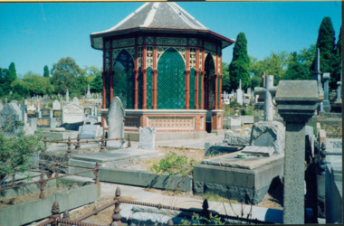 Kew Historical Society Inc
Photograph - Rotunda, Boroondara General (Kew) Cemetery
Architect and surveyor, Albert Purchas, is believed to be the designer of the cast iron entrance gates (1889), the rotunda (1890) and the surrounding ornamental brick wall (1895–6), as well as various additions to the original 1860 Cottage in the period 1866–1899 including the clock tower.Colour print positive photograph of the restored rotunda, surrounded by graves in the Boroondara (Kew) Cemetery.Nil