Showing 13401 items
matching no.15
-
 Kew Historical Society Inc
Plan, Melbourne & Metropolitan Board of Works : Borough of Kew : Detail Plan No.1576, 1904
... : Detail Plan No.1576 ...The Melbourne and Metropolitan Board of Works (MMBW) plans were produced from the 1890s to the 1950s. They were crucial to the design and development of Melbourne's sewerage and drainage system. The plans, at a scale of 40 feet to 1 inch (1:480), provide a detailed historical record of Melbourne streetscapes and environmental features. Each plan covers one or two street blocks (roughly six streets), showing details of buildings, including garden layouts and ownership boundaries, and features such as laneways, drains, bridges, parks, municipal boundaries and other prominent landmarks as they existed at the time each plan was produced. (Source: State Library of Victoria)This plan forms part of a large group of MMBW plans and maps that was donated to the Society by the Mr Poulter, City Engineer of the City of Kew in 1989. Within this collection, thirty-five hand-coloured plans, backed with linen, are of statewide significance as they include annotations that provide details of construction materials used in buildings in the first decade of the 20th century as well as additional information about land ownership and usage. The copies in the Public Record Office Victoria and the State Library of Victoria are monochrome versions which do not denote building materials so that the maps in this collection are invaluable and unique tools for researchers and heritage consultants. A number of the plans are not held in the collection of the State Library of Victoria so they have the additional attribute of rarity.Original survey plan, issued by the MMBW to a contractor with responsibility for constructing sewers in the area identified on the plan within the Borough of Kew. The plan was at some stage hand-coloured, possibly by the contractor, but more likely by officers working in the Engineering Department of the Borough and later Town, then City of Kew. The hand-coloured sections of buildings on the plan were used to denote masonry or brick constructions (pink), weatherboard constructions (yellow), and public buildings (grey). Development in the 20th century has irreparably altered that part of Kew represented in this plan. In the block bounded by Cotham Road, Charles Street, Wellington Street and Gellibrand; just one house standing in 1903 remains. This block included two of the most historic houses in Kew: ‘Ordsall’ (later ‘Southesk’) and ‘Madford’ (previously ‘Elm Lodge’). Ordsall was the home of the second chairman of Kew, John Halfey. It contained some of the most significant interior murals in Kew, created for Halfey by artists working for Cullen & Co. It was demolished in 1960 to make way for the Kew Civic Centre. Elm Lodge had been built for William Siddeley in ca. 1864. Arthur Septimus King purchased it in 1874. The lower paddocks of Madford were sold in 1905 by his wife to the Borough of Kew and, after landscaping by George and Thomas Pockett, opened as the Alexandra Gardens in 1908. Elm Lodge/Madford was in 1922 to become St. Anthony’s Home for Little Children before its subsequent demolition in the 1980s.melbourne and metropolitan board of works, detail plans, maps - borough of kew, mmbw 1576, cartography -
 Kew Historical Society Inc
Plan, Borough of Kew Detail Plan No.1577, 1904
... Borough of Kew Detail Plan No.1577 ...The Melbourne and Metropolitan Board of Works (MMBW) plans were produced from the 1890s to the 1950s. They were crucial to the design and development of Melbourne's sewerage and drainage system. The plans, at a scale of 40 feet to 1 inch (1:480), provide a detailed historical record of Melbourne streetscapes and environmental features. Each plan covers one or two street blocks (roughly six streets), showing details of buildings, including garden layouts and ownership boundaries, and features such as laneways, drains, bridges, parks, municipal boundaries and other prominent landmarks as they existed at the time each plan was produced. (Source: State Library of Victoria)This plan forms part of a large group of MMBW plans and maps that was donated to the Society by the Mr Poulter, City Engineer of the City of Kew in 1989. Within this collection, thirty-five hand-coloured plans, backed with linen, are of statewide significance as they include annotations that provide details of construction materials used in buildings in the first decade of the 20th century as well as additional information about land ownership and usage. The copies in the Public Record Office Victoria and the State Library of Victoria are monochrome versions which do not denote building materials so that the maps in this collection are invaluable and unique tools for researchers and heritage consultants. A number of the plans are not held in the collection of the State Library of Victoria so they have the additional attribute of rarity.Original survey plan, issued by the MMBW to a contractor with responsibility for constructing sewers in the area identified on the plan within the Borough of Kew. The plan was at some stage hand-coloured, possibly by the contractor, but more likely by officers working in the Engineering Department of the Borough and later Town, then City of Kew. The hand-coloured sections of buildings on the plan were used to denote masonry or brick constructions (pink), weatherboard constructions (yellow), and public buildings (grey). MMBW Plan No.1577 includes some of the most significant houses in Kew: Herbert Henty’s ‘Roxeth’ (now part of Trinity Grammar), ‘Butleigh Wooton’, ‘Bokara’ and ‘Harrow’. It also includes the streets that have since changed their names. That part of College Parade linked to Glenferrie Road is now named College Place, College Parade now extends further north, and Charles Street did not yet reach Barkers Road. Roxeth is one of a number of Henty houses in Kew. Herbert Henty made his home here and was elected a member of Kew Municipal Council in 1864 and mayor in 1868-69. Walter Henry Serle, of Harrow served in the First World War. He was awarded the Military Medal ‘’For conspicuous bravery and devotion to duty. On 29th September near BELLICOURT he showed the greatest bravery and determination when his platoon was attacked by enemy bombing parties. It was due largely to his personal efforts that all the attacks were repulsed. Until wounded, his utter disregard of personal safety and boldness in dealing with the attacks were the means of saving the situation and were an inspiring example to his men.’melbourne and metropolitan board of works, detail plans, maps - borough of kew, mmbw 1577, cartography -
 Kew Historical Society Inc
Plan, Melbourne & Metropolitan Board of Works : Borough of Kew : Detail Plan No.1578, 1904
... : Detail Plan No.1578 ...The Melbourne and Metropolitan Board of Works (MMBW) plans were produced from the 1890s to the 1950s. They were crucial to the design and development of Melbourne's sewerage and drainage system. The plans, at a scale of 40 feet to 1 inch (1:480), provide a detailed historical record of Melbourne streetscapes and environmental features. Each plan covers one or two street blocks (roughly six streets), showing details of buildings, including garden layouts and ownership boundaries, and features such as laneways, drains, bridges, parks, municipal boundaries and other prominent landmarks as they existed at the time each plan was produced. (Source: State Library of Victoria). This plan forms part of a large group of MMBW plans and maps that was donated to the Society by the Mr Poulter, City Engineer of the City of Kew in 1989. Within this collection, thirty-five hand-coloured plans, backed with linen, are of statewide significance as they include annotations that provide details of construction materials used in buildings in the first decade of the 20th century as well as additional information about land ownership and usage. The copies in the Public Record Office Victoria and the State Library of Victoria are monochrome versions which do not denote building materials so that the maps in this collection are invaluable and unique tools for researchers and heritage consultants. A number of the plans are not held in the collection of the State Library of Victoria so they have the additional attribute of rarity.Original survey plan, issued by the MMBW to a contractor with responsibility for constructing sewers in the area identified on the plan within the Borough of Kew. The plan was at some stage hand-coloured, possibly by the contractor, but more likely by officers working in the Engineering Department of the Borough and later Town, then City of Kew. The hand-coloured sections of buildings on the plan were used to denote masonry or brick constructions (pink), weatherboard constructions (yellow), and public buildings (grey). MMBW Plan No.1578 is significant in that it defines the extent of two private schools: Xavier College and Kew High School (now part of Trinity Grammar) by 1904. In relation to the latter, the plan clarifies which buildings the High School operated from behind the mansion ‘Molina’. Established in 1902, Trinity Grammar was to later lease and subsequently buy Molina (now ‘Merritt House’) and ‘Elsinore’ (now ‘Roberts House’). Xavier College had been established in 1872. This 1904 plan delineates the West Wing and the Great Hall (built in 1890).melbourne and metropolitan board of works, detail plans, maps - borough of kew, mmbw 1578, cartography -
 Kew Historical Society Inc
Plan, Melbourne & Metropolitan Board of Works. Borough of Kew Detail Plan No.1579, 1904
... Detail Plan No.1579 ...The Melbourne and Metropolitan Board of Works (MMBW) plans were produced from the 1890s to the 1950s. They were crucial to the design and development of Melbourne's sewerage and drainage system. The plans, at a scale of 40 feet to 1 inch (1:480), provide a detailed historical record of Melbourne streetscapes and environmental features. Each plan covers one or two street blocks (roughly six streets), showing details of buildings, including garden layouts and ownership boundaries, and features such as laneways, drains, bridges, parks, municipal boundaries and other prominent landmarks as they existed at the time each plan was produced. (Source: State Library of Victoria). This plan forms part of a large group of MMBW plans and maps that was donated to the Society by the Mr Poulter, City Engineer of the City of Kew in 1989. Within this collection, thirty-five hand-coloured plans, backed with linen, are of statewide significance as they include annotations that provide details of construction materials used in buildings in the first decade of the 20th century as well as additional information about land ownership and usage. The copies in the Public Record Office Victoria and the State Library of Victoria are monochrome versions which do not denote building materials so that the maps in this collection are invaluable and unique tools for researchers and heritage consultants. A number of the plans are not held in the collection of the State Library of Victoria so they have the additional attribute of rarity.Original survey plan, issued by the MMBW to a contractor with responsibility for constructing sewers in the area identified on the plan within the Borough of Kew. The plan was at some stage hand-coloured, possibly by the contractor, but more likely by officers working in the Engineering Department of the Borough and later Town, then City of Kew. The hand-coloured sections of buildings on the plan were used to denote masonry or brick constructions (pink), weatherboard constructions (yellow), and public buildings (grey). While MMBW Plan No.1579 does not include many buildings, those that it does show are significant to Kew’s history. These include the ‘Kew [Railway] Station’ in Denmark Street and the ‘Recreation Hall’ and rear courts off Wellington Street. The plan shows the outline of the Recreation Hall, constructed in 1880, at the rear of which is listed a bowling green, two tennis courts, a ‘skittle alley’ and a pavilion. When the Hall was first built, the Kew Cricket Club occupied an adjacent ground, however in 1885 this was acquired by the State Government as the future location of the Kew Railway Station. The Plan also shows a single oval at Xavier College. This oval was completed in 1883. One of the current ovals conforms to this oval’s original shape and position in the school grounds.melbourne and metropolitan board of works, detail plans, maps - borough of kew, mmbw 1579, cartography -
 Kew Historical Society Inc
Plan, Melbourne and Metropolitan Board of Works, Borough of Kew : Detail Plan No.1580, 1904
... Borough of Kew : Detail Plan No.1580 ...The Melbourne and Metropolitan Board of Works (MMBW) plans were produced from the 1890s to the 1950s. They were crucial to the design and development of Melbourne's sewerage and drainage system. The plans, at a scale of 40 feet to 1 inch (1:480), provide a detailed historical record of Melbourne streetscapes and environmental features. Each plan covers one or two street blocks (roughly six streets), showing details of buildings, including garden layouts and ownership boundaries, and features such as laneways, drains, bridges, parks, municipal boundaries and other prominent landmarks as they existed at the time each plan was produced. (Source: State Library of Victoria)This plan forms part of a large group of MMBW plans and maps that was donated to the Society by the Mr Poulter, City Engineer of the City of Kew in 1989. Within this collection, thirty-five hand-coloured plans, backed with linen, are of statewide significance as they include annotations that provide details of construction materials used in buildings in the first decade of the 20th century as well as additional information about land ownership and usage. The copies in the Public Record Office Victoria and the State Library of Victoria are monochrome versions which do not denote building materials so that the maps in this collection are invaluable and unique tools for researchers and heritage consultants. A number of the plans are not held in the collection of the State Library of Victoria so they have the additional attribute of rarity.Original survey plan, issued by the MMBW to a contractor with responsibility for constructing sewers in the area identified on the plan within the Borough of Kew. The plan was at some stage hand-coloured, possibly by the contractor, but more likely by officers working in the Engineering Department of the Borough and later Town, then City of Kew. The hand-coloured sections of buildings on the plan were used to denote masonry or brick constructions (pink), weatherboard constructions (yellow), and public buildings (grey). The area represented in this detail plan has undergone significant change during the 20th century. The widening of High Street in the 1930s and 1950s involved the shops on the south side of High Street being demolished and later rebuilt to fit the widened street. Another significant loss was the mansion ‘Drayton’ fronting Wellington Street, owned at this stage by Susannah Fenton. Her family name would later to be given to Fenton Way, which was to be built over the grounds of the house following its demolition. The plan of the garden is particularly interesting, containing a batten dome fronting Wellington Street, an ornamental pond, a fountain and a brick and glass conservatory. The notes by the plumbing contractor on this plan are particularly detailed. Pink borders delineate the ownership of the varying parcels of land. Some of the better known owners listed include the real estate agent Cr. Henry de Castres Kellett (bt) and John Padbury, the funeral director. This particular plan provides a clear view of the configuration of the Kew Junction in 1903 and the commercial buildings that surrounded it.melbourne and metropolitan board of works, detail plans, maps - borough of kew, mmbw 1580, cartography -
 Kew Historical Society Inc
Plan, Melbourne & Metropolitan Board of Works : Borough of Kew : Detail Plan No.1581, 1904
... : Detail Plan No.1581 ...The Melbourne and Metropolitan Board of Works (MMBW) plans were produced from the 1890s to the 1950s. They were crucial to the design and development of Melbourne's sewerage and drainage system. The plans, at a scale of 40 feet to 1 inch (1:480), provide a detailed historical record of Melbourne streetscapes and environmental features. Each plan covers one or two street blocks (roughly six streets), showing details of buildings, including garden layouts and ownership boundaries, and features such as laneways, drains, bridges, parks, municipal boundaries and other prominent landmarks as they existed at the time each plan was produced. (Source: State Library of Victoria)This plan forms part of a large group of MMBW plans and maps that was donated to the Society by the Mr Poulter, City Engineer of the City of Kew in 1989. Within this collection, thirty-five hand-coloured plans, backed with linen, are of statewide significance as they include annotations that provide details of construction materials used in buildings in the first decade of the 20th century as well as additional information about land ownership and usage. The copies in the Public Record Office Victoria and the State Library of Victoria are monochrome versions which do not denote building materials so that the maps in this collection are invaluable and unique tools for researchers and heritage consultants. A number of the plans are not held in the collection of the State Library of Victoria so they have the additional attribute of rarity.Original survey plan, issued by the MMBW to a contractor with responsibility for constructing sewers in the area identified on the plan within the Borough of Kew. The plan was at some stage hand-coloured, possibly by the contractor, but more likely by officers working in the Engineering Department of the Borough and later Town, then City of Kew. The hand-coloured sections of buildings on the plan were used to denote masonry or brick constructions (pink), weatherboard constructions (yellow), and public buildings (grey). The streets and built structures in this plan were surveyed in 1903 and released to contractors in 1904. In addition to the designation of building types by colour, the plan includes detailed descriptions of land use and ownership. While many buildings remain from this period, a number of the buildings represented have been demolished including the original Kew Town Hall, and the Congregational and Roman Catholic churches in Walpole Street. While the mansion ‘Illapa’ in Princess Street is still extant – now part of ‘Rylands’ – the neighbouring mansion ‘Elsmere’ was demolished some decades ago. Rivalling Illapa and Elsmere in size were two mansions in Walpole Street, one named on the plan as ‘Gnarlbine’. Over time, Kew Junction and the south side of High Street have been reconfigured and widened, so that the commercial buildings on the corner of Princess and High Street no longer exist. A surprising feature of this part of central Kew to the northwest of Kew Junction is the amount of vacant land. In a number of cases, this land is noted by the contractor as used for vegetable gardens.melbourne and metropolitan board of works, detail plans, maps - borough of kew, mmbw 1581, cartography -
 Kew Historical Society Inc
Plan, Melbourne & Metropolitan Board of Works : Borough of Kew : Detail Plan No.1582, 1904
... : Detail Plan No.1582 ...The Melbourne and Metropolitan Board of Works (MMBW) plans were produced from the 1890s to the 1950s. They were crucial to the design and development of Melbourne's sewerage and drainage system. The plans, at a scale of 40 feet to 1 inch (1:480), provide a detailed historical record of Melbourne streetscapes and environmental features. Each plan covers one or two street blocks (roughly six streets), showing details of buildings, including garden layouts and ownership boundaries, and features such as laneways, drains, bridges, parks, municipal boundaries and other prominent landmarks as they existed at the time each plan was produced. (Source: State Library of Victoria)This plan forms part of a large group of MMBW plans and maps that was donated to the Society by the Mr Poulter, City Engineer of the City of Kew in 1989. Within this collection, thirty-five hand-coloured plans, backed with linen, are of statewide significance as they include annotations that provide details of construction materials used in buildings in the first decade of the 20th century as well as additional information about land ownership and usage. The copies in the Public Record Office Victoria and the State Library of Victoria are monochrome versions which do not denote building materials so that the maps in this collection are invaluable and unique tools for researchers and heritage consultants. A number of the plans are not held in the collection of the State Library of Victoria so they have the additional attribute of rarity.Original survey plan, issued by the MMBW to a contractor with responsibility for constructing sewers in the area identified on the plan within the Borough of Kew. The plan was at some stage hand-coloured, possibly by the contractor, but more likely by officers working in the Engineering Department of the Borough and later Town, then City of Kew. The hand-coloured sections of buildings on the plan were used to denote masonry or brick constructions (pink), weatherboard constructions (yellow), and public buildings (grey). Public buildings, coloured grey on the Plan 1582 include the police station and post office, churches and schools. The earliest church school, Common School No.356 was located at the rear of the Congregational Church in Peel Street. It was constructed in 1859. The first buildings of Kew Primary School No.1075 on the other side of Peel Street were constructed in 1871. The school in 1903 only occupied a small fraction of its current site. In 1903, where the rear playground is now located, were two weatherboard and one brick villa. Trinity Grammar School was founded in 1902 and opened in the Parish Hall at the rear of Holy Trinity Anglican Church. It was not to move to its current site until 1906. The outline of the building housing the Kew Fire Brigade in the centre of the north side of Walton Street is shown but not named on the plan. Further down Pakington Street stood the two-storey Italianate mansion ‘Overton’. The home of Stanford Chapman, it was to be featured in the Imperial Institute series of bromide photographs of Victoria, Vol. 1: Homes and scenery. It was later to become a boarding house before it was later demolished.melbourne and metropolitan board of works, detail plans, maps - borough of kew, mmbw 1582, cartography -
 Kew Historical Society Inc
Plan, Melbourne & Metropolitan Board of Works : Borough of Kew : Detail Plan No.1585, 1904
... : Detail Plan No.1585 ...The Melbourne and Metropolitan Board of Works (MMBW) plans were produced from the 1890s to the 1950s. They were crucial to the design and development of Melbourne's sewerage and drainage system. The plans, at a scale of 40 feet to 1 inch (1:480), provide a detailed historical record of Melbourne streetscapes and environmental features. Each plan covers one or two street blocks (roughly six streets), showing details of buildings, including garden layouts and ownership boundaries, and features such as laneways, drains, bridges, parks, municipal boundaries and other prominent landmarks as they existed at the time each plan was produced. (Source: State Library of Victoria)This plan forms part of a large group of MMBW plans and maps that was donated to the Society by the Mr Poulter, City Engineer of the City of Kew in 1989. Within this collection, thirty-five hand-coloured plans, backed with linen, are of statewide significance as they include annotations that provide details of construction materials used in buildings in the first decade of the 20th century as well as additional information about land ownership and usage. The copies in the Public Record Office Victoria and the State Library of Victoria are monochrome versions which do not denote building materials so that the maps in this collection are invaluable and unique tools for researchers and heritage consultants. A number of the plans are not held in the collection of the State Library of Victoria so they have the additional attribute of rarity.Original survey plan, issued by the MMBW to a contractor with responsibility for constructing sewers in the area identified on the plan within the Borough of Kew. The plan was at some stage hand-coloured, possibly by the contractor, but more likely by officers working in the Engineering Department of the Borough and later Town, then City of Kew. The hand-coloured sections of buildings on the plan were used to denote masonry or brick constructions (pink), weatherboard constructions (yellow), and public buildings (grey). This plan, which covers parts of High Street, Pakington Street and Derby Street is dominated by two historic Kew mansions: ‘Konetta’ and ‘Ramornie’. Ramornie was constructed in 1890 for James Maitland Campbell, three times Mayor of Kew. Sold in 1940, it became a boarding house known as ‘The Towers’. Now a private residence again, it has only one of its three balconies remaining. The location of the missing two balconies can be seen on the plan. In 1903, the grounds of Ramornie included a large tennis court fronting Pakington Street. The rear of the property is shown as extending to Cobden Street. One of Kew’s oldest hotels, the Prospect Hill Hotel on the corner of High and Cobden Street was established in 1858. The outline of the hotel shown on the plan represents the second building on the site. During the 19th century it was often used for electoral meetings. The Prospect Hill Hotel was to be redeveloped again in 1928, by the local architect Robert McIntyre. Since the 1980s, the hotel has been a live music venue, the home of the Melbourne Jazz Club, a restaurant and a liquor outlet.melbourne and metropolitan board of works, detail plans, maps - borough of kew, mmbw 1585, cartography -
 Kew Historical Society Inc
Plan, Melbourne & Metropolitan Board of Works : Borough of Kew : Detail Plan No.1588, 1904
... : Detail Plan No.1588 ...The Melbourne and Metropolitan Board of Works (MMBW) plans were produced from the 1890s to the 1950s. They were crucial to the design and development of Melbourne's sewerage and drainage system. The plans, at a scale of 40 feet to 1 inch (1:480), provide a detailed historical record of Melbourne streetscapes and environmental features. Each plan covers one or two street blocks (roughly six streets), showing details of buildings, including garden layouts and ownership boundaries, and features such as laneways, drains, bridges, parks, municipal boundaries and other prominent landmarks as they existed at the time each plan was produced. (Source: State Library of Victoria)This plan forms part of a large group of MMBW plans and maps that was donated to the Society by the Mr Poulter, City Engineer of the City of Kew in 1989. Within this collection, thirty-five hand-coloured plans, backed with linen, are of statewide significance as they include annotations that provide details of construction materials used in buildings in the first decade of the 20th century as well as additional information about land ownership and usage. The copies in the Public Record Office Victoria and the State Library of Victoria are monochrome versions which do not denote building materials so that the maps in this collection are invaluable and unique tools for researchers and heritage consultants. A number of the plans are not held in the collection of the State Library of Victoria so they have the additional attribute of rarity.Original survey plan, issued by the MMBW to a contractor with responsibility for constructing sewers in the area identified on the plan within the Borough of Kew. The plan was at some stage hand-coloured, possibly by the contractor, but more likely by officers working in the Engineering Department of the Borough and later Town, then City of Kew. The hand-coloured sections of buildings on the plan were used to denote masonry or brick constructions (pink), weatherboard constructions (yellow), and public buildings (grey). This plan shows the original configuration of the Kew Post Office, Court House and Police Station, which had opened in 1888. This configuration was to essentially remain until the purchase of the Court House and Police Station by the City of Boroondara in 2007 and its subsequent renovation. Interestingly, the MMBW surveyors incorrectly labelled parts of the complex. In the triangle in front of the Post Office, before the erection of the Kew Cenotaph in 1925, was located a lawn and the Queen Victoria Jubilee Fountain. While many of the shops on the south side of High street had been constructed by 1903 a number of sites were still used as vegetable gardens. Further along High Street, on the corner of Charles Street, the Salvation Army Barracks can be seen on the plan. These Barracks predate the later Citadel and ‘Young People’s Hall’ that were opened in 1919. At 22 Charles Street can be seen the house of James Venn Morgan. Hailed as the ‘father of Kew’, Morgan arrived in Melbourne in 1840. He was first engaged as a bookmaker, but a fortunate venture on the goldfields enabled him to purchase land in Kew. He conducted a market garden and dairy in Kew for many years.melbourne and metropolitan board of works, detail plans, maps - borough of kew, mmbw 1588, cartography -
 Kew Historical Society Inc
Plan, Melbourne & Metropolitan Board of Works : Borough of Kew : Detail Plan No.1590, 1905
... : Detail Plan No.1590 ...The Melbourne and Metropolitan Board of Works (MMBW) plans were produced from the 1890s to the 1950s. They were crucial to the design and development of Melbourne's sewerage and drainage system. The plans, at a scale of 40 feet to 1 inch (1:480), provide a detailed historical record of Melbourne streetscapes and environmental features. Each plan covers one or two street blocks (roughly six streets), showing details of buildings, including garden layouts and ownership boundaries, and features such as laneways, drains, bridges, parks, municipal boundaries and other prominent landmarks as they existed at the time each plan was produced. (Source: State Library of Victoria)This plan forms part of a large group of MMBW plans and maps that was donated to the Society by the Mr Poulter, City Engineer of the City of Kew in 1989. Within this collection, thirty-five hand-coloured plans, backed with linen, are of statewide significance as they include annotations that provide details of construction materials used in buildings in the first decade of the 20th century as well as additional information about land ownership and usage. The copies in the Public Record Office Victoria and the State Library of Victoria are monochrome versions which do not denote building materials so that the maps in this collection are invaluable and unique tools for researchers and heritage consultants. A number of the plans are not held in the collection of the State Library of Victoria so they have the additional attribute of rarity.Original survey plan, issued by the MMBW to a contractor with responsibility for constructing sewers in the area identified on the plan within the Borough of Kew. The plan was at some stage hand-coloured, possibly by the contractor, but more likely by officers working in the Engineering Department of the Borough and later Town, then City of Kew. The hand-coloured sections of buildings on the plan were used to denote masonry or brick constructions (pink), weatherboard constructions (yellow), and public buildings (grey). Surveyed by the Board of Works in 1903 and published in 1904, Plan No.1590 shows development north of Cotham Road. While this plan includes built structures in Mary Street, Cotham Road, High Street, Park Hill Road, Kent Street, Ridgeway Avenue, and Ermington Lane (now Ermington Place), only part of this section was notated and coloured in this contractor’s copy. Numerous houses, large and small are named on the plan: ‘Cholula’, ‘Belper’, ‘The Uplands’, ‘Spring Grove’ facing Cotham Road; ‘Marion’ facing Kent Street; and ‘Kia Ora’ facing Ridgeway Avenue.melbourne and metropolitan board of works, detail plans, mmbw 1590, survey plans - borough of kew, cartography -
 Kew Historical Society Inc
Plan, Melbourne & Metropolitan Board of Works : Borough of Kew : Detail Plan No.1591, 1905
... : Detail Plan No.1591 ...The Melbourne and Metropolitan Board of Works (MMBW) plans were produced from the 1890s to the 1950s. They were crucial to the design and development of Melbourne's sewerage and drainage system. The plans, at a scale of 40 feet to 1 inch (1:480), provide a detailed historical record of Melbourne streetscapes and environmental features. Each plan covers one or two street blocks (roughly six streets), showing details of buildings, including garden layouts and ownership boundaries, and features such as laneways, drains, bridges, parks, municipal boundaries and other prominent landmarks as they existed at the time each plan was produced. (Source: State Library of Victoria)This plan forms part of a large group of MMBW plans and maps that was donated to the Society by the Mr Poulter, City Engineer of the City of Kew in 1989. Within this collection, thirty-five hand-coloured plans, backed with linen, are of statewide significance as they include annotations that provide details of construction materials used in buildings in the first decade of the 20th century as well as additional information about land ownership and usage. The copies in the Public Record Office Victoria and the State Library of Victoria are monochrome versions which do not denote building materials so that the maps in this collection are invaluable and unique tools for researchers and heritage consultants. A number of the plans are not held in the collection of the State Library of Victoria so they have the additional attribute of rarity.Original survey plan, issued by the MMBW to a contractor with responsibility for constructing sewers in the area identified on the plan within the Borough of Kew. The plan was at some stage hand-coloured, possibly by the contractor, but more likely by officers working in the Engineering Department of the Borough and later Town, then City of Kew. The hand-coloured sections of buildings on the plan were used to denote masonry or brick constructions (pink), weatherboard constructions (yellow), and public buildings (grey). That area of Kew bordered by Cotham Road, Park Hill Road, Ermington Lane (now Ermington Place), and Belmont Avenue contained some of the significant homes owned by Kew pioneers. Chief among these was ‘Park Hill’ on an enormous lot facing Park Hill Road. The Jubilee History of 1910 noted, six years after this plan was drawn, that: ‘Park Hill Road, forming the southern boundary of the cemetery, takes its name from Park Hill, the residence of Mr. Thomas Judd, who has resided there since December, 1852.’ Other named houses on the plan include ‘Ferndale’ facing Cotham Road; ‘Ermington’ adjacent to Judd’s Park Hill, facing Park Hill Road; and ‘Gilden’ and ‘Mont Belmont’ facing Belmont Avenue. Mont Belmont was designed by the architectural firm of Reed, Henderson and Smart for William George Lilley in 1887 and was completed in 1888. Lilley was Mayor of Kew in 1887-88, a Justice of the Peace and a member of the first Board of Guardians of Kew’s St. Hilary’s Church of England.melbourne and metropolitan board of works, detail plans, survey plans - borough of kew, mmbw 1591, cartography -
 Kew Historical Society Inc
Plan, Melbourne & Metropolitan Board of Works : Borough of Kew : Detail Plan No.1592, 1905
... : Detail Plan No.1592 ...The Melbourne and Metropolitan Board of Works (MMBW) plans were produced from the 1890s to the 1950s. They were crucial to the design and development of Melbourne's sewerage and drainage system. The plans, at a scale of 40 feet to 1 inch (1:480), provide a detailed historical record of Melbourne streetscapes and environmental features. Each plan covers one or two street blocks (roughly six streets), showing details of buildings, including garden layouts and ownership boundaries, and features such as laneways, drains, bridges, parks, municipal boundaries and other prominent landmarks as they existed at the time each plan was produced. (Source: State Library of Victoria). This plan forms part of a large group of MMBW plans and maps that was donated to the Society by the Mr Poulter, City Engineer of the City of Kew in 1989. Within this collection, thirty-five hand-coloured plans, backed with linen, are of statewide significance as they include annotations that provide details of construction materials used in buildings in the first decade of the 20th century as well as additional information about land ownership and usage. The copies in the Public Record Office Victoria and the State Library of Victoria are monochrome versions which do not denote building materials so that the maps in this collection are invaluable and unique tools for researchers and heritage consultants. A number of the plans are not held in the collection of the State Library of Victoria so they have the additional attribute of rarity.Original survey plan, issued by the MMBW to a contractor with responsibility for constructing sewers in the area identified on the plan within the Borough of Kew. The plan was at some stage hand-coloured, possibly by the contractor, but more likely by officers working in the Engineering Department of the Borough and later Town, then City of Kew. The hand-coloured sections of buildings on the plan were used to denote masonry or brick constructions (pink), weatherboard constructions (yellow), and public buildings (grey). In MMBW Plan No.1592, the pink line indicates that area of the plan for which the contracting engineer was responsible. Included in the Plan are a number of primarily brick villas in a section of Belmont Avenue off Cotham Road. The house ‘Uvadale’ north of Belmont Avenue, and facing Cotham Road is also included in the contract. Excluded from the contract but shown on the Plan are ‘Glendonald’, ‘Mont Belmont’ and ‘Gilden’.melbourne and metropolitan board of works, detail plans, survey plans - borough of kew, mmbw 1592, cartography -
 Kew Historical Society Inc
Plan, Melbourne & Metropolitan Board of Works / Borough of Kew, Detail Plan No.1593, 1905
... , Detail Plan No.1593 ...The Melbourne and Metropolitan Board of Works (MMBW) plans were produced from the 1890s to the 1950s. They were crucial to the design and development of Melbourne's sewerage and drainage system. The plans, at a scale of 40 feet to 1 inch (1:480), provide a detailed historical record of Melbourne streetscapes and environmental features. Each plan covers one or two street blocks (roughly six streets), showing details of buildings, including garden layouts and ownership boundaries, and features such as laneways, drains, bridges, parks, municipal boundaries and other prominent landmarks as they existed at the time each plan was produced. (Source: State Library of Victoria)This plan forms part of a large group of MMBW plans and maps that was donated to the Society by the Mr Poulter, City Engineer of the City of Kew in 1989. Within this collection, thirty-five hand-coloured plans, backed with linen, are of statewide significance as they include annotations that provide details of construction materials used in buildings in the first decade of the 20th century as well as additional information about land ownership and usage. The copies in the Public Record Office Victoria and the State Library of Victoria are monochrome versions which do not denote building materials so that the maps in this collection are invaluable and unique tools for researchers and heritage consultants. A number of the plans are not held in the collection of the State Library of Victoria so they have the additional attribute of rarity.Original survey plan, issued by the MMBW to a contractor with responsibility for constructing sewers in the area identified on the plan within the Borough of Kew. The plan was at some stage hand-coloured, possibly by the contractor, but more likely by officers working in the Engineering Department of the Borough and later Town, then City of Kew. The hand-coloured sections of buildings on the plan were used to denote masonry or brick constructions (pink), weatherboard constructions (yellow), and public buildings (grey). The laborious task of hand-tinting these Board of Works plans was not without hazards as is evidenced by Plan No. 1593. On the Plan, the original colourist spilt black and green ink, partially obscuring some parts. The most obvious casualty is ‘Clifton’ located on the corner of Cotham Road and Park Street [now Adeney Avenue]. Included in this Plan, and outlined in pink is that part of the section that the contracting engineer was tasked with completing. This included sewering on both sides of this part of Cotham Road, but excluded properties such as ‘Glendonald’ and ‘Monnington’. This area was to undergo a series of subdivisions including the ‘Clifton Estate’, which created housing lots on Adeney Avenue and Florence Avenue in 1916. The most notable occupant of Clifton was William Adeney [died 1893], a pioneer of Camperdown, after which Park Street was later renamed.melbourne and metropolitan board of works, detail plans, survey plans - borough of kew, mmbw 1593, cartography -
 Kew Historical Society Inc
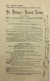
Pamphlet - Document, St Hilary's Anglican Church, St Hilary's Parish Notes, No.70., March 1919, 1919
... St Hilary's Parish Notes, No.70., March 1919 ...St Hilary's Anglican Church in Rowland Street, Kew was established in 1888 on land granted to the congregation by the Dumaresq family.The Parish Notes are historically interesting as they outline the various ways in which the Influenza Epidemic of 1919 had an impact on local communities. St Hilary's Church of England Parish Notes from 1919, which includes among other items of interest states that because of the risks of contagion during the influenza epidemic, parishioners are required to worship outside. Written note on front page signed by the Rev Charles H Barnes and dated 16/3/19.st hilary's church of england - kew (vic), churches - kew (vic), influenza epidemic 1919 - kew (vic) -
 Kew Historical Society Inc
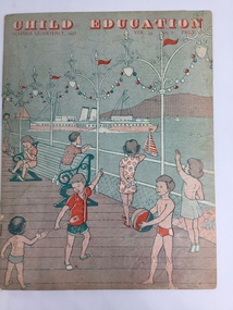
Magazine - Periodical, Messrs Evans Bros Ltd, Child Education : Summer Quarterly, 1958, Vol. 35 No. 7, 1958
... Child Education : Summer Quarterly, 1958, Vol. 35 No. 7 ...The Child's Education magazines were published for British teachers between 1924 and 2007 to help them plan activities for the season ahead. The internal pages contain a variety of lesson ideas in the form of a music, art or craft activities. This copy was donated to the Kew Historical Society's collection by the Preshil archives.This 1958 periodical, sourced from the Preshil School. is interesting as it represents the continuing influence of English education and culture in the Australian curriculum in the late 1950s.20 page newsletter containing artwork and articles on the theme shipping and boats. Text on page 3 describes the subject of the issue as 'Around our Coasts'. This is amplified by the text as: "In preparation for the children's seaside holiday, descriptions and pictures of ships, boats and lighthouses, and their work are contained in this issue. Suggestions for handwork are also given. The wall picture [not included with this item] in full colour illustrates many different ships which the children might see at the seaside or on a river estuary."periodicals -- child education uk, themes -- shipping and boats, messrs evans bros ltd -
 Kew Historical Society Inc
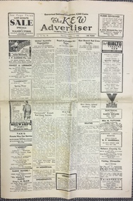
Newspaper, W D Vaughan Pty Ltd, The Kew Advertiser, Vol.16 No.38, Thursday October 2 1941, 2 October 1941
... The Kew Advertiser, Vol.16 No.38, Thursday October 2 1941 ...The Kew Advertiser was a major local Kew newspaper founded in 1926. It was owned by William David Vaughan who was a prominent member of the Kew community. Vaughan also served as a Councillor in the City of Kew for many years, and as Mayor in 1937-38, 1947-48 and 1961-62.Broadsheet newspaper printed in black ink, front page shows advertisements for local businesses on outside edges, has cross-shaped fold creases where the paper has be folded into quarters.newspapers -- kew (vic), w d vaughan, kew advertiser, newspapers -- kew (vic.) -- 1940s -
 Kew Historical Society Inc
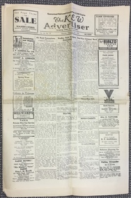
Newspaper, W D Vaughan Pty Ltd, The Kew Advertiser, Vol.16 No.37, Thursday September 25 1941, 25/09/1941
... The Kew Advertiser, Vol.16 No.37, Thursday September 25 ..."The Kew Advertiser , published by WD Vaughan Pty Ltd, commenced publication in January 1926 and, before the year's end, a modern printing plant had been established at 128 Denmark Street (demolished). This later became the nerve centre for publication of four other local newspapers: The Hawthorn Standard (1932), the Eastern Suburbs Advertiser (1934), the Coburg Courier (1935) and the Brunswick Sentinel (1936). The last two were later sold to another publisher, and the remaining three merged in 1959 to form the Eastern Suburbs Standard. This, in turn, continued under that name until 1974, when it merged with a counterpart from Doncaster, the Whitehorse Standard, and then carried on (under various names) until 1980." (Source: City of Boroondara : Thematic Environmental History, p. 75)Kew Newspaper produced in 1941 by W D Vaughamn Pty Ltd. The newspaper was printed at his offices in Denmark Street. The banner headline claims that it had a distribution of 6,000 copies.the kew advertiser, newspapers -- kew (vic), wd vaughan pty ltd -
 Kew Historical Society Inc
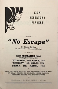
Programme - Theatre Programme, No Escape / by Rhys Davies in collaboration with Archibald Batty, 1958
... No Escape / by Rhys Davies in collaboration with Archibald ...From the early 1950s, the Kew Repertory Players performed more substantial, if less spectacular fare in the Recreation Hall, and later in the new Kew City Hall, after the former’s demolition in 1960. Their repertoire ranged from plays by Noel Coward to J.B. Priestley. Many of their programmes, the earliest from 1953, and the last from 1965, form part of our collection.Arthur Henry Dear was an employee of the City of Kew, acting as Hall Keeper of the Kew Recreation Hall in Wellington Street, and later the new Kew City Hall in Cotham Road. The Arthur Dear Collection contains memorabilia - tickets, programmes, invitations - as well as his identification badge. Items in the collection dates from the 1940s to the 1970s. The Kew Recreation Hall (Wellington Street) and later the Kew City Hall (Cotham Road) were major locations in suburban Melbourne in the postwar period for civic and private events including theatre productions and exhibitions. The Arthur Dear Collection (in conjunction with the scrapbooks compiled by Marion Tilley) provide a comprehensive snapshot of performing arts in Kew during the 1940s, 1950s and 1960s. The collection includes valuable data about performances, performers, directors etc., during this period. Programme issued by The Kew Repertory Players for a performance of No Escape, a play written by Rhys Davies in collaboration with Archibald Batty. Performances took place in the Kew Recreation Hall in March 1958. The 4-page programme includes a cast list, a synopsis and advertisements for local businesses.no escape, rhys davies, archibald batty, kew repertory players, arthur dear collection, performing arts -- kew -- victoria, kew recreation hall -- wellington street, theatre memorabilia -
 Kew Historical Society Inc
Plan - Subdivision Plan, Lodged Plan No.6518, 1920-1940
... Lodged Plan No.6518 ...The Kew Historical Society collection includes almost 100 subdivision plans pertaining to suburbs of the City of Melbourne. Most of these are of Kew, Kew East or Studley Park, although a smaller number are plans of Camberwell, Deepdene, Balwyn and Hawthorn. It is believed that the majority of the plans were gifted to the Society by persons connected with the real estate firm - J. R. Mathers and McMillan, 136 Cotham Road, Kew. The Plans in the collection are rarely in pristine form, being working plans on which the agent would write notes and record lots sold and the prices of these. The subdivision plans are historically significant examples of the growth of urban Melbourne from the beginning of the 20th Century up until the 1980s. A number of the plans are double-sided and often include a photograph on the reverse. Reconciling this hand-drawn subdivision plan with a modern map of the area is initially a challenge due to a change of street names. Argyle Road in the centre of the subdivision was to be renamed Deepdene Road, and the street named Deepdene Road on the plan was to become Deepdene Place. Of interest is the nursery on the corner of Argyle and Whitehorse Roads. During this period there were a number of nurseries servicing the Kew and Balwyn areas. The subdivision was essentially of the land formerly occupied by the house 'Deepdene'.subdivision plans - balwyn, deepdene, whitehorse road -- deepdene (vic.), deepdene road -- deepdene (vic.), burke road -- deepdene (vic.) -
 Kew Historical Society Inc
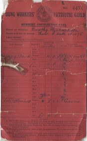
Document, Young Workers Patriotic Guild - Members Contribution Card, No. 4472, 1914-1918
... , No. 4472 ...This work forms part of the collection assembled by the historian Dorothy Rogers, that was donated to the Kew Historical Society by her son John Rogers in 2015. The manuscripts, photographs, maps, and documents were sourced by her from both family and local collections or produced as references for her print publications. Many were directly used by Rogers in writing ‘Lovely Old Homes of Kew’ (1961) and 'A History of Kew' (1973), or the numerous articles on local history that she produced for suburban newspapers. Most of the photographs in the collection include detailed annotations in her hand. The Rogers Collection provides a comprehensive insight into the working habits of a historian in the 1960s and 1970s. Together it forms the largest privately-donated collection within the archives of the Kew Historical SocietyA red cash record card used by Dorothy Richardson of Gladstone Street Kew to record donations to patriotic causes in the First World War while a student of Kew Primary School.Dorothy Rogers Kew State No.1075 [etc]young workers patriotic movement, dorothy rogers, kew primary school, first world war (1914-18) -
 Kew Historical Society Inc
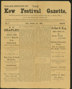
Newspaper, Kew Festival Gazette, No.1, October 5th 1895, 1895
... Kew Festival Gazette, No.1, October 5th 1895 ...The first known use of the term 'Kew Festival'.The Kew Festival Gazette, 5 October 1895 is a four-page mock-up newspaper, published from the Boroondara Standard office to advertise and publicise a Kew Festival. The Festival was not associated with the current Kew Festival, which was founded in 1974, but was principally a bazaar held in the Kew Recreation Hall to raise money for the Kew Catholic Church Building Fund which was associated with the Jesuit Mission. Perhaps because of the recent economic depression, the Mission was in financial difficulties and it was hoped that the bazaar would raise enough money to ease the situation. According to the Gazette, ‘All Kew has been in a gentle simmer of excitement for some time past over the coming Sacred Heart Bazaar in aid of the Jesuit Mission funds. Wherever one goes the talk is of the bazaar, and whoever one meets is either a stallholder, an assistant or an intending purchaser.’ There are a few items in the Gazette about other local events, including a cake fair and sale of works, and a history of bazaars that traces them from the Middle East via Britain to Kew. One article contains some examples of nineteenth century humour, including ‘the lady stallholders will not have to pay income tax on their takings’. The advertisements reflect the goods and services available to Kew residents in 1895 – groceries, wine & spirits, hay, corn, chaff, ironmongery, timber, drapery, millinery, gas cookers, and an undertaker and embalmer. kew festival gazette, kew catholic church, boroondara standard -
 Kew Historical Society Inc
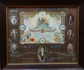
Certificate - Framed Testimonial, Royal Industry Lodge No. 4831, Port Phillip District
... Royal Industry Lodge No. 4831, Port Phillip District ...The Port Phillip District Branch of the Manchester Unity I.O.O.F. in Victoria was registered on 5 September 1857.A framed commemorative certificate presented to Mary L. Cranston in recognition of her services to the Port Phillip District Branch of the Manchester Unity Independent Order of Oddfellows (MUIOOF). In addition to the photograph of the recipient, six other photographs of officers of the lodge are included. The imagery of the certificate references western art and Christian symbolism, as well as obligatory references to labour and learning. Mary Cranston is pictured centre front."Royal Industry Lodge No.4831, Port Phillip District M.U.I.O.O.F., Presented to Sister Mary L. Cranston for services rendered.m.u.i.o.o.f, muioof, lodge, oddfellows,, royal industry lodge, mary cranston, mary l. cranston, a.h. nitz, e. bloxham, a. newbegin, f.p. brown, e. jones, j.n. trawin, howard brown, eden studios, friendly society, port phillip, dove, loyal industry lodge no.4831, calligraphy, illumination -
 Kew Historical Society Inc
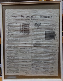
Newspaper - Framed Newspaper, The Boroondara Standard, The Boroondara Standard No.288 Vol.6, Thursday February 8th 1883, 1883
... The Boroondara Standard No.288 Vol.6, Thursday February 8th ...The Boroondara Standard was published by W. Axford, Hawthorn, Vic. between 1884-1897Rare print copybook a newspaper in Kew for the 19th centuryFramed issue of the 'Boroondara Standard and Bulleen, Nunawading, and Lillydale Advertiser' - No.288 Vol.6, Thursday February 8th 1883. The newspaper wa issued from 1882-1897.newspapers -- kew (vic.), newspaper the boroondara standard -
 Kew Historical Society Inc
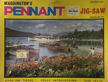
Leisure object, Waddingtons, Bowness Bay, Design No.753 : Waddington's Pennant Vari-Piece Jig-Saw, c.1965
... Bowness Bay, Design No.753 : Waddington's Pennant Vari ...Waddingtons is a famous card and board manufacturer. It commenced business in 1927 and produced jig-saw puzzles from the mid 1930s. Their Christmas, Map, and circular jig-saw series were their most popular jig-saws. Various-piece jig-saws were introduced c.1965 and were very popular in the 1960s and 1970s.Jig-Saw puzzle in original box depicting Bowness Bay on cover. Bowness Bay is in the Lake District, Cumbria (UK). The puzzle has 340 pieces.Exterior of Box: " Waddington's Pennant Jig-Saw. Over 340 pieces, fully interlocking, Size 19" x 11 3/8. / Design No. 753 Bowness Bay"jig-saw puzzle, waddingtons, bowness bay - cumbria --- uk -
 Kew Historical Society Inc
Journal, The Kewriosity Sheet Vol.1 No.1 : June 1979
... The Kewriosity Sheet Vol.1 No.1 : June 1979 ...What is THIS Kewriosity Sheet? Where did it come from? What's it for? / [Cr] Kaye Cole [Mayor of Kew] p1. What's doing in Kew during June / p1. Those vacant dates / p1. People wanted [Mount Royal Henry Pride Geriatric Centre] / p1. Pensioners' Association /p1. We need your news / p1. The birth of a village [Kew history] / H. Rolley p2. Limerick of the month / p2. Kew Chess Club -1979 Championships / p2. Kew Rovers start well [The Kew Rovers Football Club] / p2. The Copy Shop / p2. Area Playgroups / p2. Council News - Stradbroke Park Pavilion; Recreational Achievement of the Year Award; Kew Elder Citizens' Club / p2. Winter Sporting Activities Operating Throughout Kew / p2. Citizens' Advice Bureau / p2.The Kewriosity Sheet (1979-83) was first published in the City of Kew (Victoria) in June 1979 as a two-sided 'community newssheet'. It aimed to: 'share news about Kew happenings and Kew people, and to exchange ideas about living in Kew'. Later issues gradually evolved into a 4-page, quarto sized publication. The Kewriosity Sheet was superseded by the Kew Council publication 'Kewriosity' (1983-1994).non-fictionWhat is THIS Kewriosity Sheet? Where did it come from? What's it for? / [Cr] Kaye Cole [Mayor of Kew] p1. What's doing in Kew during June / p1. Those vacant dates / p1. People wanted [Mount Royal Henry Pride Geriatric Centre] / p1. Pensioners' Association /p1. We need your news / p1. The birth of a village [Kew history] / H. Rolley p2. Limerick of the month / p2. Kew Chess Club -1979 Championships / p2. Kew Rovers start well [The Kew Rovers Football Club] / p2. The Copy Shop / p2. Area Playgroups / p2. Council News - Stradbroke Park Pavilion; Recreational Achievement of the Year Award; Kew Elder Citizens' Club / p2. Winter Sporting Activities Operating Throughout Kew / p2. Citizens' Advice Bureau / p2.community publications --- kew (vic.), the kewriosity sheet, newsletters - kew (vic.) -
Kew Historical Society Inc
Journal, The Kewriosity Sheet Vol.1 No.2 : July 1979
... The Kewriosity Sheet Vol.1 No.2 : July 1979 ...What is Kew Community Care? / p1. What's doing in Kew for July / p1. Hi neighbour [Barrington Street] / p1. Keep the mini-bus running [Kew Community Bus] / p1. Thank you everybody {contributors] / p1. Anyone for Bocce? / p1. Art School for School [Xavier College] / p1. Nominations for [Kew] Council / p1. Kew Historical Society / p2. Limerick of the month / p2. Arts & Crafts at Trinity [Grammar School] / p2. Glad Street Kindergarten / p2. The Copy Shop / p2. Parlez Vous? [Migrant English] / p2. Children's art [Deepdene Primary School] / p2. Save the Children Fund / p2. Morning for S.C.F/ / p2. The 'Widow" is back [Starlight Theatrical Company] / p2 Council News [Council elections, Planning for Melbourne; Energy; Efficiency; Employment; Environment] / p2. Citizens Advice Bureau [Unemployment; Home Savings Grants] / p2.The Kewriosity Sheet (1979-83) was first published in the City of Kew (Victoria) in June 1979 as a two-sided 'community newssheet'. It aimed to: 'share news about Kew happenings and Kew people, and to exchange ideas about living in Kew'. Later issues gradually evolved into a 4-page, quarto sized publication. The Kewriosity Sheet was superseded by the Kew Council publication 'Kewriosity' (1983-1994).non-fictionWhat is Kew Community Care? / p1. What's doing in Kew for July / p1. Hi neighbour [Barrington Street] / p1. Keep the mini-bus running [Kew Community Bus] / p1. Thank you everybody {contributors] / p1. Anyone for Bocce? / p1. Art School for School [Xavier College] / p1. Nominations for [Kew] Council / p1. Kew Historical Society / p2. Limerick of the month / p2. Arts & Crafts at Trinity [Grammar School] / p2. Glad Street Kindergarten / p2. The Copy Shop / p2. Parlez Vous? [Migrant English] / p2. Children's art [Deepdene Primary School] / p2. Save the Children Fund / p2. Morning for S.C.F/ / p2. The 'Widow" is back [Starlight Theatrical Company] / p2 Council News [Council elections, Planning for Melbourne; Energy; Efficiency; Employment; Environment] / p2. Citizens Advice Bureau [Unemployment; Home Savings Grants] / p2.community publications --- kew (vic.), the kewriosity sheet, newsletters - kew (vic.) -
Kew Historical Society Inc
Journal, The Kewriosity Sheet Vol.1 No.3 : August 1979
... The Kewriosity Sheet Vol.1 No.3 : August 1979 ...What's doing in Kew for August / p1. We want your news! / p1. Kew Municipal Library: Where children are VIP / p1. 25 years of service: Kew Lions Anniversary / p1. Miss Shepheard retires [Stawell Street Kindergarten] / p1. Studley Park Progress Association / p1. Entertainers needed [Kew Entertainment Workshop] / p1. Rotaract ski weekend / p1. Kew Historical Society: Memorials in Kew / p2. Children's Week 1979 / p2. Limerick of the month / p2. Theatre in Education [Kew High School] / p2. Nursing Mothers Association / p2. Mid-week tennis / p2. [Kew] Swimming Club / p2. Help where it's needed [Sacred Heart Kew Caring Group] / p2. Kew City Bowmen / p2. Holiday help [Meals on Wheels] / p2. Child Development Seminar / p2. Council News: For your safety [Roundabouts; If you're un-building [demolitions]; Traffic School; School Holidays] / p2. Citizens' Advice Bureau / p2.The Kewriosity Sheet (1979-83) was first published in the City of Kew (Victoria) in June 1979 as a two-sided 'community newssheet'. It aimed to: 'share news about Kew happenings and Kew people, and to exchange ideas about living in Kew'. Later issues gradually evolved into a 4-page, quarto sized publication. The Kewriosity Sheet was superseded by the Kew Council publication 'Kewriosity' (1983-1994).non-fictionWhat's doing in Kew for August / p1. We want your news! / p1. Kew Municipal Library: Where children are VIP / p1. 25 years of service: Kew Lions Anniversary / p1. Miss Shepheard retires [Stawell Street Kindergarten] / p1. Studley Park Progress Association / p1. Entertainers needed [Kew Entertainment Workshop] / p1. Rotaract ski weekend / p1. Kew Historical Society: Memorials in Kew / p2. Children's Week 1979 / p2. Limerick of the month / p2. Theatre in Education [Kew High School] / p2. Nursing Mothers Association / p2. Mid-week tennis / p2. [Kew] Swimming Club / p2. Help where it's needed [Sacred Heart Kew Caring Group] / p2. Kew City Bowmen / p2. Holiday help [Meals on Wheels] / p2. Child Development Seminar / p2. Council News: For your safety [Roundabouts; If you're un-building [demolitions]; Traffic School; School Holidays] / p2. Citizens' Advice Bureau / p2. community publications --- kew (vic.), the kewriosity sheet, newsletters - kew (vic.) -
Kew Historical Society Inc
Journal, The Kewriosity Sheet Vol.1 No.4 : September 1979
... The Kewriosity Sheet Vol.1 No.4 : September 1979 ...What's doing in Kew for September / p1. A to Z of Road Safety: Safety for the children / p1. APECS-PLAN Pedal for people bicycle rally / p1. Kew Historical Society: Schools / p2. That school holiday feeling! [poem] / p2. How many young unemployed / p2. Athletics [Kew-Camberwell District Amateur Athletic Club]/ p2. Youth Accommodation Services Programme / p2. After School activities / p2. Are you a busy woman? / p2. Parent support [Kew Pre-School Support Group] / p2. Council News [Elections - Max Sartori; Peter Wallinga; Jim McCue; Bill Cook; Walter Haldun; Bob Pritchard; Joe Omando] / p2. Rotoractors celebrate / p2. Kew Girl Guides / p2. F.A.C.S. [Family and Community Services Program] / p2. Helping the community /p2.The Kewriosity Sheet (1979-83) was first published in the City of Kew (Victoria) in June 1979 as a two-sided 'community newssheet'. It aimed to: 'share news about Kew happenings and Kew people, and to exchange ideas about living in Kew'. Later issues gradually evolved into a 4-page, quarto sized publication. The Kewriosity Sheet was superseded by the Kew Council publication 'Kewriosity' (1983-1994).non-fictionWhat's doing in Kew for September / p1. A to Z of Road Safety: Safety for the children / p1. APECS-PLAN Pedal for people bicycle rally / p1. Kew Historical Society: Schools / p2. That school holiday feeling! [poem] / p2. How many young unemployed / p2. Athletics [Kew-Camberwell District Amateur Athletic Club]/ p2. Youth Accommodation Services Programme / p2. After School activities / p2. Are you a busy woman? / p2. Parent support [Kew Pre-School Support Group] / p2. Council News [Elections - Max Sartori; Peter Wallinga; Jim McCue; Bill Cook; Walter Haldun; Bob Pritchard; Joe Omando] / p2. Rotoractors celebrate / p2. Kew Girl Guides / p2. F.A.C.S. [Family and Community Services Program] / p2. Helping the community /p2. community publications --- kew (vic.), the kewriosity sheet, newsletters - kew (vic.) -
Kew Historical Society Inc
Journal, The Kewriosity Sheet Vol.1 No.5 : October 1979
... The Kewriosity Sheet Vol.1 No.5 : October 1979 ...What's doing in Kew for October / p1. Keeping Kew beautiful [Parks and Gardens: Alexandra Gardens - Kew; Kew Garden Club; Willsmere Park; Victoria Park; Eglinton Reserve] / p1. Your news is good news / p1. Got some spare time [Henry Pride] / p1. Young people's club [Fitzwilliam Street People's Church] / p1. Fun and fellowship [Kew Uniting Church Youth Group] / p1. Learn to swim next year! / p1. Bring your orchid [Kew Garden Club] / p2. Retired and looking for something to do? [Kew Elder Citizens] / p2. Your help needed [The Kewriosity Sheet] / p2. [Aphorisms] / p2. Songs my mother sang / p2. Recreation courses / p2. Multiple Sclerosis Unit / p2. You you get ideas? [East Kew Uniting Church] / p2. E.P.R.G. (Early Planning for Retirement Group] / p2. Mum - It's for you! / p2. Action for the handicapped / p2. Biggest rug in the world / p2. Council News [City Hall Bookings; Town Planning; Unburnable rubbish; Family Day Care Scheme; Community Occupational Therapist; Kew Community Directory; Come meet your Mayor (Cr Kaye Cole) / p2. Do it yourself duplicating [Copy Shop] / p2. Meals on - tables [Kew Elderly Citizens' Club] / p2.The Kewriosity Sheet (1979-83) was first published in the City of Kew (Victoria) in June 1979 as a two-sided 'community newssheet'. It aimed to: 'share news about Kew happenings and Kew people, and to exchange ideas about living in Kew'. Later issues gradually evolved into a 4-page, quarto sized publication. The Kewriosity Sheet was superseded by the Kew Council publication 'Kewriosity' (1983-1994).non-fictionWhat's doing in Kew for October / p1. Keeping Kew beautiful [Parks and Gardens: Alexandra Gardens - Kew; Kew Garden Club; Willsmere Park; Victoria Park; Eglinton Reserve] / p1. Your news is good news / p1. Got some spare time [Henry Pride] / p1. Young people's club [Fitzwilliam Street People's Church] / p1. Fun and fellowship [Kew Uniting Church Youth Group] / p1. Learn to swim next year! / p1. Bring your orchid [Kew Garden Club] / p2. Retired and looking for something to do? [Kew Elder Citizens] / p2. Your help needed [The Kewriosity Sheet] / p2. [Aphorisms] / p2. Songs my mother sang / p2. Recreation courses / p2. Multiple Sclerosis Unit / p2. You you get ideas? [East Kew Uniting Church] / p2. E.P.R.G. (Early Planning for Retirement Group] / p2. Mum - It's for you! / p2. Action for the handicapped / p2. Biggest rug in the world / p2. Council News [City Hall Bookings; Town Planning; Unburnable rubbish; Family Day Care Scheme; Community Occupational Therapist; Kew Community Directory; Come meet your Mayor (Cr Kaye Cole) / p2. Do it yourself duplicating [Copy Shop] / p2. Meals on - tables [Kew Elderly Citizens' Club] / p2. community publications --- kew (vic.), the kewriosity sheet, newsletters - kew (vic.) -
Kew Historical Society Inc
Journal, The Kewriosity Sheet Vol.1 No.6 : November 1979
... The Kewriosity Sheet Vol.1 No.6 : November 1979 ...What's doing in Kew for November / p1. Evaluation time! [Survey: The Kewriosity Sheet] / p1. Your news is good news / p1. Kew Op Shop / p1. Do it yourself duplicating [The Copy Shop] / p1. Toastmasters Club commences in Kew / p2. Hey kids!! Did you know? / p2. Park is beautiful asset [Yarra Bend Park; Studley Park Progress Association] / p2. Jobs wanted / p2. Kew Philharmonic Society / p2. Eat Kew Primary School [Reading; Concert Band] / p2. Playgroup [Uniting Church Highbury Grove] / p2. Show, Sell and Tell night [Gardening] / p2. Council News [Home help; A new group in Kew; Swimming Pool; Immunisations; Dog registrations; Valuations; Rates] / p2.The Kewriosity Sheet (1979-83) was first published in the City of Kew (Victoria) in June 1979 as a two-sided 'community newssheet'. It aimed to: 'share news about Kew happenings and Kew people, and to exchange ideas about living in Kew'. Later issues gradually evolved into a 4-page, quarto sized publication. The Kewriosity Sheet was superseded by the Kew Council publication 'Kewriosity' (1983-1994).non-fictionWhat's doing in Kew for November / p1. Evaluation time! [Survey: The Kewriosity Sheet] / p1. Your news is good news / p1. Kew Op Shop / p1. Do it yourself duplicating [The Copy Shop] / p1. Toastmasters Club commences in Kew / p2. Hey kids!! Did you know? / p2. Park is beautiful asset [Yarra Bend Park; Studley Park Progress Association] / p2. Jobs wanted / p2. Kew Philharmonic Society / p2. Eat Kew Primary School [Reading; Concert Band] / p2. Playgroup [Uniting Church Highbury Grove] / p2. Show, Sell and Tell night [Gardening] / p2. Council News [Home help; A new group in Kew; Swimming Pool; Immunisations; Dog registrations; Valuations; Rates] / p2.community publications --- kew (vic.), the kewriosity sheet, newsletters - kew (vic.)