Showing 14064 items
matching properties
-
 Andrew Ross Museum
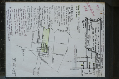
research note, A4, Donaldson property, Waterdale Rd with sketch maps, Early 1990's
The Donalsdons of Kangaroo Ground owned property fronting Waterdale Rd West Heidelberg, used to camp cattle overnight on their way to/from saleyards in Melbourne.Prepared and used in the writing of "Kangaroo Ground: The Highland Taken (Mick Woiwod 1994)single sheet with 2 hand-drawn maps, annotated by Bruce Nixon. Notes refer to the Will of James Donaldson (D.1856) Could be a good photocopy with green pencil shading donaldson, nixon, bellevue, wellington house -
 Tatura Irrigation & Wartime Camps Museum
Multi ringed folder, Kaye Watson, Internment camp No 3. Rushworth Migrant camp
The camp sites today are on private property, and as they were dismantled after the war, and on the closure of the Migrant camp, very little physical evidence remains today.Camp 3 held 1000 internees, Germans, Jews and Italians, including German Lutheran families from New Guinea, German families from Palestine (Templer settlement) and Austrian Jewish refugees. After the war camp 3 became the first camp for Displaced persons in Victoria, where families could live until work and accommodation was found for them.Many pages, with 12 photos on each page, of scenes showing the remains from camp 3camp 3 rushworth -
 Lake Bolac & District Historical Society
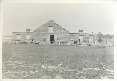
black and white photograph, Eilyer Station Woolshed
Photograph of the bluestone woolshed located on 'Eilyer' Station 12 kilometres south of Lake Bolac. Built circa 1860. Owners of property the Austin FamilyBlack and white photographaustin, woolshed, bluestone, eilyer -
 Hume City Civic Collection
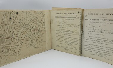
Correspondence Book, c1890s
A book with printed perforated pages to send one half to owner of property demanding outstanding payment of rates prior to Council taking possession of land.A mottled blue and brown hard cover book with black spine. Printed and handwritten pages. Printed pattern very worn on front and back covers."Shire of Bulla/Notice of Intention..."1890s, shire of bulla, george evans collection -
 National Wool Museum
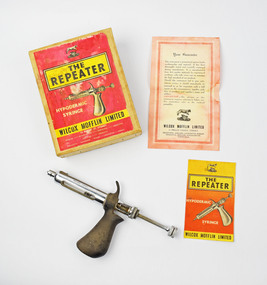
Syringe
Hypodermic syringe gun in box donated by Tom Crocker (former Operations Manager, National Wool Museum), used on father's property in Violet Town.Metal hypodermic syringe gun.The Repeater Hypodermic syringe Wilcox Mofflin Limitedsheep dipping, crocker, mr tom - national wool museum -
 Stawell Historical Society Inc
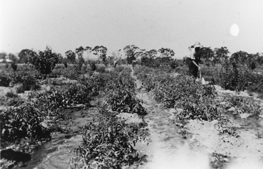
Photograph, Mr Stan Cox at the Hines Tomato Growing Property in Pomonal
Tomato Growing at Hines property Pomonal. Stan Cox in foreground digging with people in the background. The tomato's plants are being irrigated with water along the rows.Black and white photograph of a scene depicting watering a vegetable crop. Two people are working the crop in the background and in the foreground a person is digging. Stan Cox watering Hines Tomatoes Pomonal.stawell -
 Whitehorse Historical Society Inc.
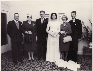
Photograph, Mullens/Blanksby Wedding
The Mullens family were one of the first to settle in the East Burwood area. They were orchardists with property on the north-west corner of Burwood and Springvale Roads.Black and white photograph of the marriage of Ivan Mullens of East Burwood, to Joy Blanksby. From right to left - Bruce Roy Mullens, Thelma Mary Mullens, Groom and Bride, Glen Blanksby, Harold Blanksby. The group is in a reception room with a leaf-patterned carpet.blanksby, joy, mullens, ivan, bruce roy, thelma mary, glen, harold -
 City of Ballarat Libraries
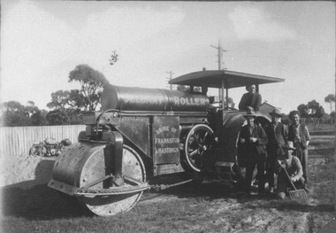
Photograph, Jelbart Road Roller circa 1930s
Jelbart Road Roller property of Shire of Frankston and Hastings circa 1930. This roller was manufactured in Ballarat by Jelbarts, whose foundry was located in Mair Street. jelbart, road roller, mair street, manufacturing, foundry, frankston, hasting, ballarat -
Lakes Entrance Regional Historical Society (operating as Lakes Entrance History Centre & Museum)
Photograph, 2003
Also two other views of the Carpenter House property taken by Judy Davies 04678 .1 and 04678 .2 10 x 15 cmColour photograph of the Carpenter house taken after renovations and repainting New Works Lakes Entrance Victoriacelebrations, community facilities, historic sites, tourism -
 Expression Australia
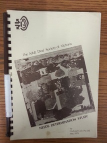
Book, The Adult Deaf Society of Victoria Needs Determination Study
A study into whether the property of The Adult Deaf Society of Victoria at Jolimont meets the needs of the Deaf community. Prepared by Civil and Civic Pty.Ltd. May 1979 Spiral bound, 29.5cmHx21cmW, 92 pagesthe adult deaf society of victoria, jolimont property, civil and civic pty.ltd. -
 Stawell Historical Society Inc
Photograph, Canoe Trees in Lubeck
Canoe Trees – Lubeck. This is one of sereral such trees on the property of Bill Kinsella near Lubeck. One was removed to a park in Horsham on a low loader in 1997.Colour photo of Canoe treestawell -
University of Melbourne, Burnley Campus Archives
Journal, Royal Society of Victoria, Proceedings of the Royal Society of Victoria, 1935-1945
A. W. Jessep (Principal) Associate Member. Probably all volumes his property H. W. Gepp Ordinary Member signed on most volumesscience -
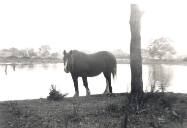 City of Kingston
Photograph - Digital image, Black and white, c. 1950
Horse standing by a lake on the property of the Methodist Children's Homes, Cheltenham. The photograph is taken from Tennyson Street, looking towards Point Nepean Road.This image shows the land in Cheltenham, that later became Southland Shopping Centre. The land originally belonged to the Methodist Church, who operated a Children's Home on the property.Black and white image of a horse standing next to a tree trunk by a lake. cheltenham, methodist children's homes, southland, environment -
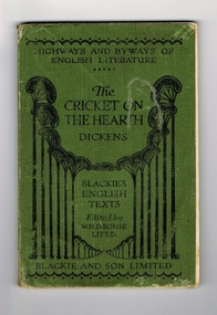 Kiewa Valley Historical Society
Book - Reference Cricket, The Cricket on the Hearth, circa 1930
A text book used by a local Tawonga student in the 1930's. The school she attended was Rosehill Girls School in Albury. This was one of the foundation schools of Scots School, Albury. Rosehill was opened in 1926 by a Miss Lillian Windridge, for both day and boarding students, in a large former residential property on the corner of Crisp and Young Streets and was named after her uncle's property 'Rosehill' near Kyneton in Victoria. It catered from kindergarten to the Leaving Class. The school flourished and extra space was made available at the adjacent 'Springfield' property for more classrooms. In 1934 lack of space forced 'Rosehill' to move to a new location in Kiewa Street. In 1938, Miss Windridge sold the school to Miss Anna Drennan, a well educated Scots woman with a Masters' degree from Edinburgh University. By early 1939 the school was again overcrowded and was moved to the property 'Woodstock' in Schubach Street, East Albury and the name changed to 'Woodstock School for Girls'. In 1972, the Woodstock Presbyterian Girls School and the Albury Grammar School amalgamated to form the Scots School Albury. Wilma's family were one of the early families to settle in the Kiewa Valley and had a property at Tawonga. After her marriage, Wilma moved, with her husband, to Mt. Beauty until 1958 when they moved back to manage the farm and remained there for the rest of her life.It has a social significance as it depicts the standard of literature that was expected to be read and appreciated by students in the 1930's era. As the school was situated in Albury, it meant that the student would have been a boarder as daily transport to and from the Kiewa Valley would have been impossible at that time, unlike the 'School Bus' run that is available today. At this time there was no 'secondary education' available in the valley and education beyond primary school would have been limited to children of families that could afford to send their children to board at privately run schools.Book of literature by Charles Dickens. Has green cover with black lettering and decoration. It seems to be one of a series of books called the 'Highways and Byways of English Literature". On the front cover, at the top, 'Highway and Byways of English Literature'. Centre of page is the title "The Cricket on the Hearth" and the author Dickens. Underneath this is 'Blackies English Texts Edited by W.H.D.Rouse, Litt.D." Across the foot of the page is 'Blackie and Son Limited'. On the first page, hand written in ink is "Wilma Roper, Rosehill G.S.,Albury."secondary education, albury, kiewa valley, tawonga -
 Surrey Hills Historical Society Collection
Photograph, Grovedale Road Quarry in the 1920s - looking north, c1920
The quarry was part of John Butler Maling's property. He was one of the original settlers of the area and farmed the area between Weybridge Street and Whitehorse Road. Clay was quarried from part of this area and used to make the bricks used in the construction of his home, known as 'Ancyra'. This is still extant at the corner of Weybridge and James Streets. Maling grazed cows and used the quarry as a water source. He was the uncle of John Butler Maling, Mayor of Camberwell. He was married to Kate Conlon in 1882. They had 3 children: Silas Young, Alick and Zillah. Maling was born in c1829 in Shepreth, Cambridgeshire; he died in Surrey Hills on 9 October 1912 and is buried in Box Hill Cemetery - CE-*-0586. Mrs Kate Maling (born c1859 in Co Meath, Ireland) died at the property on 8 March 1921. She is buried in Brighton General Cemetery. Probate was valued at over 10,000 pounds and included other properties in Sandringham, Hawthorn and Macedon. At the time of her death the Surrey Hills property was described as being 23 cres with 2 brick houses, 1 cow, 2 heifers and 40 fowls or chickens. The property was subdivided after her death. The quarry was filled in after several drownings or near drownings and the land is now occupied by a park and playground maintained by the City of Boroondara. Beckett Park is sited on horizon to the left beyond the trees. This documents the landscape prior to close settlement and is material to early building and farming in the Surrey Hills area.Black and white photo of the quarry between Grovedale Road and James Street taken in the 1920s and looking north. In the foreground is an area of water with high banks dividing the horizontal centre. Beyond are paddocks and trees behind which is a row of at least 3 single-storey houses. Light poles can be seen along a distant street. There are many mature trees in the background. The houses and trees are positioned along Whitehorse Road in the vicinity of Westminster Street. Shadows indicate the photo was taken in early morning or evening.quarries, grovedale road, james street, surrey hills, balwyn, clay quarries, ancyra, kate conlon, kate maling, john butler maling, farming -
Glen Eira Historical Society
Article - Regent Street, 50, Elsternwick
Two items about this property: Newspaper advertisement dated 02/11/2005, source unknown, advertising the forthcoming 19/11/2005 auction of 50 Regent Street, Elsternwick. Gives brief details on the property interior and exterior. Research note by Claire Barton, dated 06/06/2012, referencing Sands and McDougall editions, 1913, 1923, 1948, 1960 and 1970, giving names of previous tenants at 50 Regent Street.elsternwick, regent street, cottages, cast iron work, tosin paul, stavrakis bill, real estate agents, herbert ralph, capuano chas m, eldred c m, eldred m, smith regd t -
Glen Eira Historical Society
Article - Koornang Road, 85-87, Carnegie
A colour newspaper article in the Property Review Weekly of 18/10/2002, advertising the forthcoming auction of 85-87 Koornang Road on 31/10/2002. The article includes a colour photograph of the building exterior. The file also includes a colour newspaper article from the Property Review Weekly of 25/10/2002, describing 85-87 Koornang Road and discussing the forthcoming auction. The article includes a colour photograph of the building exterior.carnegie, koornang road, shops, auctions, pharmacies, safeway supermarket, coles supermarket, breheny nicholas -
Glen Eira Historical Society
Document - Brewer Road, 8, Bentleigh
A copy of a two page valuation letter, dated 18/04/1966, to McKenzie and Ross Solicitors to a valuator, regarding the estate of John H Holmes at Brewer Road, 8, Bentleigh and including a description of the land and house improvements. The file also includes two pages of handwritten working notes for the purposes of the property valuation. The file also includes a two page typed document, undated, containing an inventory and valuation of furniture and effects of the property.holmes john h, brewer road, bentleigh, thomas street, bentleigh west state school, nepean highway, brick houses, furniture, furnishings -
 Eltham District Historical Society Inc
Slide, Site of proposed Yarra Brae Dam, Jul. 1973
With an increasing need to grow Melbourne's water supply, in 1973, the State Government announced plans for the development of Sugarloaf Reservoir. Two dams were to be built, one across the Yarra from the Yarra Brae property in Wonga Park to the Bend of Isles. Water was to be pumped from this dam to the higher level Sugarloaf Reservoir. The proposed extensive flooding of large numbers of properties resulted in significant community backlash and ultimately abandonement of the proposed Yarra Brae dam.35 mm colour positive transparency (x 3) Mount - Kodak Kodachrome Cardyarra brae dam -
Glen Eira Historical Society
Ephemera - ROSENEATH, NEPEAN HIGHWAY, 31, ELSTERNWICK
This file contains 8 pages and one property notice. The file contains: 1/descriptions from Andrew Ward’s Heritage Planning Report. Notes on residents of ‘Roseneath’ from 1866 to 1963. Articles include household goods sale, public notices, wills and estate notices from Trove and census record. Details from Ancestry.com 2016. 2/Property sale notice of ‘Roseneath’ dated 04/03/2016 from Leader newspaper.‘roseneath’, house names, point nepean road, elsternwick, bogle andrew esq., auctions, wragge william, wragge mary, wragge william charles, miller william, councillors, rusden street, mcmillan street, subdivision, boyle andrew, merchants, shire of caulfield, east st kilda riding, breckinhill lodge, bogle andrew mrs., wragge w mrs, st kilda cemetery, cemeteries, kirkham councillor, long councillor, riddell councillor, lempriere councillor, ilberry concillor, worthington george, judges, tulloch annie, st kilda ladies benevolent society, worthington mrs, wheeldon isaac, tulloch w.g., breweries, elsternwick, madame berry west company, tulloch and son, mccracken’s brewery, elsternwick station, ‘elderslie’, glenhuntly road, wheeldon sarah, cross anastacia, brick houses, meek alexander charles, meek una eveline, meek david, meek jane, meek james, meek alexander, meek kathleen, meek william, lloyd i. captain, lloyd mary, lloyd nova, lloyd eileen, meek anastasia mary, meek william john, meek monica venus, engineers, marine surveyors, social events and activities, wills and estates, real estate, advertisements -
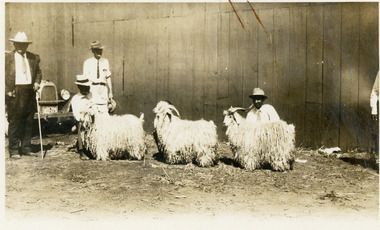 National Wool Museum
Photograph, Angora Bucks, 19/5/1960
Angora goats are believed to have originated in the Himalaya Mountains of Asia. Angora goats were first imported into Australia in 1832 and 1833. They came from M Polonceau’s stud in France to the property of the Riley family of Raby N.S.W. Pure bred Angoras were imported from Turkey in subsequent years up to 1873, to properties in New South Wales, Victoria, and later South Australia. Farming Angora goats became popular in the 1970s.Sepia photo of three Angora Goat Bucks with four men wearing white shirts and and brim hats in a landscape format.On rear top edge - Duaes(?) Anorgra Bucks 19-560wool, angora goat, goat -
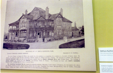 Whitehorse Historical Society Inc.
Photograph, Bundoora Park Homestead
In 1899 John Vincent Smith acquired the property known as 'Bundoora Park'. In the same year he organised a public competition for a design for a house to be built on the property. The competition (worth $50) was won by architect Sydney Herbert Wilson who also designed the Malvern Town Hall. In 1990 a fourteen room mansion was erected. The Australia Tesselated Tile Co of Mitcham supplied most of the tiles for the walls and floors, and Griffins and Lilials for the roof decoration.Coloured photograph detailing the history of Bundoora Park Homestead, Bundoora. Features a drawing of the mansion. The Australian Tesselated Tile Co. Pty Ltd of Mitcham supplied tiles and other materials.bundoora park homestead, australian tesselated tile co pty ltd, tiles -
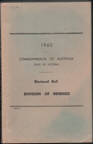 Bendigo Historical Society Inc.
Administrative record - Electoral Roll, 1915
Voting registers, or electoral rolls, are a census of those who were eligible to vote. They are valuable because a country-wide census was not taken until 1911. Early electoral rolls give an individual name, residence, status of property occupation/ownership, and the rate value of the property. Electoral Rolls are arranged by electoral district and subdistrict. Name, Address, Occupation and gender for thirteen subdivisions. Electoral rolls were published by each state during election years.Electoral Roll for the Commonwealth Division of Bendigo, State Assembly District of Bendigo, and State Electoral Province of Bendigo for 1960 (made up to 23rd September 1960). Includes Name, Address, Occupation and gender for thirteen subdivisions. Assembled and bound with string, with a faded light green card cover..electoral rolls, voting in bendigo -
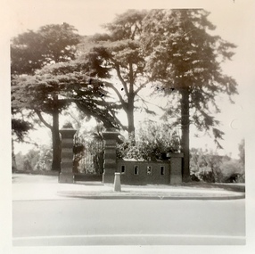 Kew Historical Society Inc
Photograph - Gates of 'Raheen', Studley Park Road, 1981
The first section of Raheen was commenced in 1870 with an extension added in 1884. It was designed by William Salway and built for Edward Latham of the Carlton Brewery. Sir Henry Wrixon, prominent Melbourne barrister and solicitor, later owned and resided at the property. In 1917 Raheen was purchased by the Catholic Church and became the official residence of Archbishop Mannix, as well as four other Catholic archbishops of Melbourne. In 1981 the Church sold the property and it again reverted to a private residence. (Source: VHD)Photographic positive showing the gates to the mansion 'Raheen' in Studley Park Road. Notable are the three Himalayan Cedars inside and outside the high brick fence.Verso: "Gates to Raheen 1981"raheen -- studley park road -- kew (vic.), mansions -- studley park -- kew (vic.), historic houses -- studley park -- kew (vic.), raheen -
 Eltham District Historical Society Inc
Photograph - Digital Photograph, Alan King, Rob Roy Hill Climb, 24 November 2007
The Rob Roy Hill Climb originated in 1935 on the property of former Heidelberg Mayor, William Clinton, where he reared the Rob Roy breed of miniature ponies. He established Pleasure Grounds on part of the property attracting groups of Sunday visitors from Melbourne's inner suburbs. Visitors enjoyed a picnic area, pony rides, a dance hall and a tap room. Young men would ride their BSA or Harley Davidson motorcycles to the property which led to regular club-organised hillclimb meetings between 1930 and 1936. In 1935 Clinton offered the use of his property to the Light Car Club of Australia for their hillclimbs. The track was sealed that same year and the hillclimb at Clintons Road was one of only three specially designed bitumen surface hillclimbs in the world, the others being Shelsey Walsh and Prescott Hillclimbs in the UK. The first Light Car Club of Australia hillclimb was held at Rob Roy in February 1937. Covered under Heritage Overlay, Nillumbik Planning Scheme. Published: Nillumbik Now and Then / Marguerite Marshall 2008; photographs Alan King with Marguerite Marshall.; p133This collection of almost 130 photos about places and people within the Shire of Nillumbik, an urban and rural municipality in Melbourne's north, contributes to an understanding of the history of the Shire. Published in 2008 immediately prior to the Black Saturday bushfires of February 7, 2009, it documents sites that were impacted, and in some cases destroyed by the fires. It includes photographs taken especially for the publication, creating a unique time capsule representing the Shire in the early 21st century. It remains the most recent comprehenesive publication devoted to the Shire's history connecting local residents to the past. nillumbik now and then (marshall-king) collection, rob roy hill climb, clintons road, light car club of australia, william clinton -
Glen Eira Historical Society
Letter - Kooyong Road, 98, Caulfield North
This file has 4 items: 1/Copy of letter dated October 4, 1972 from Blake and Riggall Solicitors, acting for the Trustees of the Estate of the F.C. Pederson to the tenant of trust property at 98 Kooyong Road, A.F. Gregson. Requests cooperation in inspection of premises for a possible rent increase to satisfy life tenant. Includes handwritten annotations possibly for valuation purposes. 2/Letters dated October 4, 1972 from Blake & Riggall to S.P. Simmonds Real Estate Agents concerning inspection of the relevant property, requesting opinion on a fair rental and valuation. 3/Copy of a letter dated October 17, 1972 from S.D. Simmonds to Blake & Riggall providing details of the relevant property, estimates of the cost of improving, options for increasing the life tenant’s income and a valuation. 4/Letter dated October 23, 1972 from Blake & Riggall to S.P. Simmonds acknowledging the previous letter and outlining which option the trustee’s prefer and how they wish to proceed. Discussion of property rates and annual insurance premiums. Includes handwritten notes.pederson f.c., gregson a.f., mackinnon i.d., pederson mrs., balaclava road, kooyong road, caulfield, brick houses, rents, land values, rates, renting -
 Surrey Hills Historical Society Collection
Photograph, "Ancyra" 25 Weybridge Street, Surrey Hills
John Butler Maling, retired farmer, built his home on the corner of his property which extended from Weybridge Street to Whitehorse Road and from James to Ross Street. From 1853 he lived in a simple farmhouse located near the present Ross Street until he had 'Ancyra' built in c.1889 from bricks made from clay dug from a quarry on the property. This was located in the now-park in James Street. John Butler Maling Snr was born in Shepreth, Cambridgeshire. He married Kate Conlan in 1882 and they had 3 children - Silas, Alick and Zillah. He died in 1912 and is buried in Box Hill Cemetery. Often referred to as John Butler Maling Senior as he had a nephew by the same name. He also lived on a similar sized property known as 'The Willows', located to the west. He became the first Mayor of Camberwell. From c1936 til c1960 the property was used as a rest home (Ancyra Rest Home) and then a nursery (Pied Piper Nursery).This property is important as one of few remaining extant links to pre-urban Surrey Hills, and built from local material.A black and white photograph of a brick house with a slate roof and corrugated iron over the verandah and portico. A picket fence painted a dark colour features decorative finals on the tops of the posts.ancyra, house names, weybridge street, surrey hills, whitehorse road, james street, ross street, john butler maling (snr), mrs kate maling, silas maling, alick maling, zillah maling, miss kate conlan, box hill cemetery, ancyra rest home, pied piper nursery -
 Surrey Hills Historical Society Collection
Photograph, "Ancyra", 25 Weybridge Street, Surrey Hills
John Butler Maling, retired farmer, built his home on the corner of his property which extended from Weybridge Street to Whitehorse Road and from James to Ross Street. From 1853 he lived in a simple farmhouse located near the present Ross Street until he had 'Ancyra' built in c.1889 from bricks made from clay dug from a quarry on the property. This was located in the now-park in James Street. John Butler Maling Snr was born in Shepreth, Cambridgeshire. He married Kate Conlan in 1882 and they had 3 children - Silas, Alick and Zillah. He died in 1912 and is buried in Box Hill Cemetery. Often referred to as John Butler Maling Senior as he had a nephew by the same name. He also lived on a similar sized property known as 'The Willows', located to the west. He became the first Mayor of Camberwell. From c1936 til c1960 the property was used as a rest home (Ancyra Rest Home) and then a nursery (Pied Piper Nursery). This is one of relatively few surviving houses that provides links to pre0urban Surrey Hills. It is also built from locally quarried material.A black and white photograph of a house viewed through the front garden.ancyra, house names, weybridge street, surrey hills, james street, bricks, john butler maling senior, miss kate conlan, mrs kate maling, alick maling, silas maling, zillah maling, ancyra rest home, pied piper nursery, box hill cemetery -
 Wodonga & District Historical Society Inc
Photograph - Cambourne House
Cambourne homestead was built by 1903 for Rebecca S. Carkeek, who purchased the property in Wodonga in 1899. Cambourne is situated on the original Wodonga Run which was established in 1836. In 1855 the pre-emptive right of 171 acres of the Wodonga Run was granted and sold the following year. The allotments on which the five-acre Cambourne property developed, were purchased in 1873 and 1876, coinciding with the opening of the Railway from Melbourne. The property was purchased by Rebecca Carkeek in June 1899, wife of William Carkeek, Publican of Wodonga and Shire Councillor. Local architects Gordon and Gordon have been credited with the design of Cambourne. The house at Cambourne was built at some stage between 1900 and 1903 as a large single storey homestead. It was constructed in red brick with corrugated iron roof and encircling verandah. Cambourne is a probable work of architects Gordon and Gordon, it is amongst their best preserved and one of their few surviving buildings in Victoria. Today Cambourne remains on a reduced allotment due to the acquisition of land in 1972 by the Country Roads Board and in 2006 by Vic Roads for road works adjacent to the property.Cambourne, Wodonga is of architectural and historical significance to the State of Victoria.A set of coloured photos depicting Cambourne in Wodonga. Part of a collection documented a heritage listed pioneer home.cambourne wodonga, cambourne homestead wodonga, historic buildings wodonga -
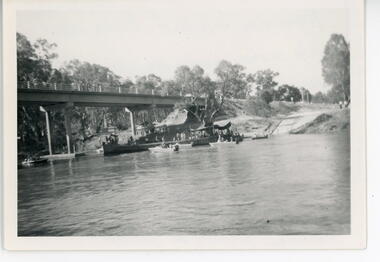 Port of Echuca
Black and white photograph, 1971
This is a photograph showing the P.S. Alexander Arbuthnot about to be removed from the water to be transported to Shepparton for restoration. The Alexander Arbuthnot was pulled off the bottom of the river at Yielma in July 1972 and taken to Shepparton via Barmah in January 1973.This photograph is significant as it shows the P.S Alexander Arbuthnot about to come out of the river, to be fully restored.A black and white photograph 13 cms X 9 cms of the P.S Alexander Arbuthnot under the Barmah Bridge, prior to being taken out of the river and taken to Shepparton.Written on the back of the photo are the following words. "Alexander Arbuthnot being moved into position under the Barmah Bridge prior to removal from the water and transported to Shepparton for restoration 1971 - 1973. The paddle screamer was previously sunk near the Victorian bank. At Newmans property at Yielma." paddle steamers, ralton, greg, shepparton, p.s alexander arbuthnot, international village shepparton, yielma