Showing 10429 items
matching sites
-
 Buninyong & District Historical Society
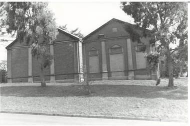
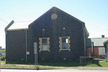
Photograph - B/W photograph, Buninyong Masonic Lodge, 1993
Masonic presence in Buninyong since the nineteenth century, this is the second lodge built on the same site.Early twentieth century public buildingBlack and white photograph of Buninyong Masonic Lodge, a brick building located on the western side of Warrenheip South.buninyong, masonic lodge, building -
 Glenelg Shire Council Cultural Collection
Domestic object - Dish, n.d
Found at ship wreck site off Neve Valley by abalone diver in the early 1990s6 sided glass dish. Clear glass with pattern on sides and base. No major chips out of glass. Calcium deposits on one side.Front: - Back: -shipwreck, glass dish, diver -
 Bendigo Military Museum
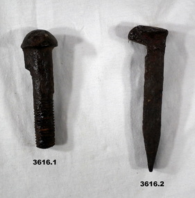
Equipment - RAILWAY HARDWARE, c,1940 - 1944
All objects supposedly brought from somebody near the site of the Thai Burma Railway..1) Rusted metal bolt. .2) Rusted metal spike. .3) Rusted bent piece of metal with pointed ends.equipment, railway, burma -
Lakes Entrance Regional Historical Society (operating as Lakes Entrance History Centre & Museum)
Photograph, 2006
Built on site of Carpenters Camp Park residence which was relocated to Hunters Lane in 2003Colour photograph of Lakes Sports and Community Club on Esplanade shows single story building with modern facade, child playground beside lawns in foreground Lakes Entrance Victoriabusinesses -
 Lakes Entrance Regional Historical Society (operating as Lakes Entrance History Centre & Museum)
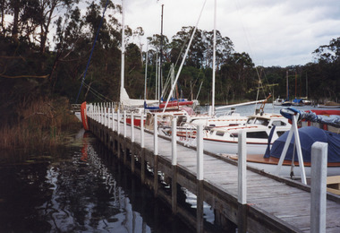
Photograph, 1999
Site occupied by Chinese fishermen and gardeners late 1800's and early 1900's.Colour photograph of the jetty at Chinaman's Creek showing yachts and launches moored on lake side of jetty, moored yachts visible in distance under timbered bank. Metung Victoriahouses, heritage study -
 Ballarat Tramway Museum
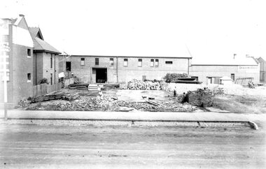
Photograph - Geelong MESCO offices, c.1900-10
Site cleared for construction of MESCO offices on SW corner of Yarra and Corio Sts., Geelong.Yields information on early Geelong streetscape and constructionBlack and white print on paper.Plate 2-8 Spare written in ink on the back of the photograph.mesco geelong, corner yarra and corio sts. geelong -
 Greensborough Historical Society
Photograph - Digital Image, Marilyn Smith, Mernda Mechanics Institute 2018, 27/09/2018
In 2018 GHS members visited Turner's Bakery in Mernda for lunch and continued on to visit historic sites remaining in the Mernda area. This photograph shows the Mernda Mechanics Institute, established 1888. It was sited to the rear of the Bridge Inn Hotel on land donated by the hotel's owner. Today the Mechanic's institute is a small hall available to rent.Mernda is an area of rapid modern growth with a few remaining historic buildings dating from the 19th century.Digital copy of colour photographsmernda, mernda historic sites, mernda mechanics institute, mechanics institutes victoria, bridge inn hotel mernda -
 Greensborough Historical Society
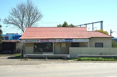
Photograph - Digital Image, Mernda Post Office 2018, 25/07/2019
In 2018 GHS members visited Turner's Bakery in Mernda for lunch and continued on to visit historic sites remaining in the Mernda area. This photograph shows the Mernda Post Office, formerly the Mernda General Store. It is sited in Schotters Road. Today the Post Office has been relocated to modern premises in Mernda Village Drive.Mernda is an area of rapid modern growth with a few remaining historic buildings dating from the 19th century.Digital copy of colour photographmernda, mernda historic sites, mernda post office, schotters road mernda, post offices, mernda general store -
 Greensborough Historical Society
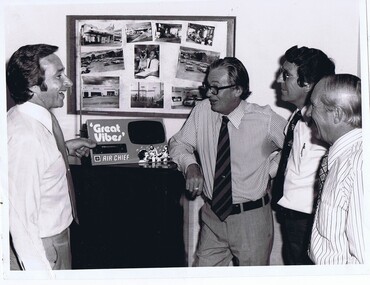
Photograph - Digital image, Purcell Stubley and staff, 1970s
Purcell Stubley with staff from Stubley Motors. The Stubley Group began in 1946 when Purcell Stubley purchased a site with petrol bowsers in Main Street from 'Snowy' Jessop. In 1948 Purcell began building the new Stubley Motors, working round the old site to keep the business operating. It was completed in 1951.Digital copy of black and white photographpurcell stubley, stubley motors -
 Greensborough Historical Society
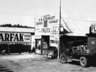
Photograph - Digital Image, Stubley Garage 1946, 1946_
Main Street view of Stubley Motors 1946. The Stubley Group began in 1946 when Purcell Stubley purchased a site with petrol bowsers in Main Street from 'Snowy' Jessop. In 1948 Purcell began building the new Stubley Motors, working round the old site to keep the business operating. It was completed in 1951.Digital copy of black and white photographpurcell stubley, stubley motors -
Federation University Historical Collection
Document, Allum Lovell, Former Ballarat Brewery Conservation Analsysis, c1990
Carlton and United Breweries purchased the Ballarat Brewering Company Limited site in 1958, including its chain of 114 hotels. In the mid 1980s CUB transferred the production of Blalarat Bertie to the Abbotsford plants and started producing Guimes under license in the Ballarat plant. On 30 June 1989 CUB closed the Ballarat site.Report conducted by Allum Lovell for the Ballarat School of Mines. former ballarat brewery, conservation management plan, james coglan, william kenna, tulluch and mclaren, phoenix brewery, chimney, brew tower, cooling tower, carlton and united breweries, brewery building -
 Eltham District Historical Society Inc
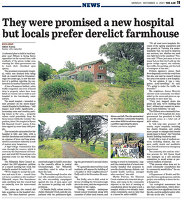
Newspaper - News Clipping, Adam Carey, They were promised a new hospital, but locals prefer derelict farmhouse, The Age, December 4, p11, 2023
The Age, Monday, December 4, 2023, p11 Article about local protest at Victorian Government decision to build a community hospital on the site of an old derleict farmhouse owned by the Department of Transport at 405 Ryans Road, Diamond Creek. The site was until 2017 part of a potential route fior the North East Link.community hospital, cr. ben ramcharan, cr. natalie duffy, department of ttransport, diamond creek, eltham community hospital, james bant, james merrett, martin penrose, north east link, petition, protest, ryans road -
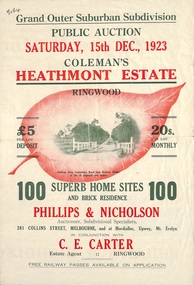 Ringwood and District Historical Society
Flyer, Land Sale Brochure, Coleman's Heathmont Estate, Ringwood, Vic. - 1923
Bi-fold advertisement for auction sale of residential sites, including photographs, map, and summary of subdivision features and local facilities. Auction date Saturday 15th December, 1923. Subsequent auction date Saturday 19th January, 1924, following previous sale stopped on account of rain. Initial newspaper advertisement (publication unknown) dated 16/11/23.Subdivision includes Bedford Road, Canterbury Road, Alvena Crescent, Leonard Street (later Royal Avenue), and Coleman Street. Agent - Phillips & Nicholson, 281 Collins Street Melbourne, (Phone) Central 10907, in conjunction with C.E. Carter, Main Street, Ringwood. Tel. Ringwood 24. -
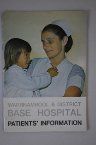 Warrnambool and District Historical Society Inc.
Booklet, Warrnambool & District Base Hospital Patients' information, C1970
This booklet outlines procedures and rules which pertain to the Warrnambool base Hospital. It covers such items as services, admissions, meals, visitors, blood donors, charges, and complaints. A small booklet with social and historical interest to the district.16 page booklet with image of a nurse with a child in her arms on the front cover and text in grey and black on a white background.Back cover has a photograph a woman in a wheelchair with four hospital staff. below is a red cross in a circle with Warrnambool and district Base Hospital around it.It has a map of the site and a table of contents outlining aspects of procedures arpund the hospital.Photography : Roger Lee. Printed by Philprint Warrnambool.warrnambool base hospital, warrnambool, warrnambool and district base hospital -
Tatura Irrigation & Wartime Camps Museum
Photograph, 31/3/1916
Taken by photographer for State Rivers and Water Supply Commission.Medium sized black and white photograph. Sugarloaf Reservoir pay day / R. Burns, Senior Constable Waters, P. Descrimes, G Robinson and other men grouped around the short-sleeved paymaster / Pay books on trestle table on construction site / Timber chute running down hill beyond men / All men wearing hats.victorian state rivers and supply commission, sugarloaf reservoir -
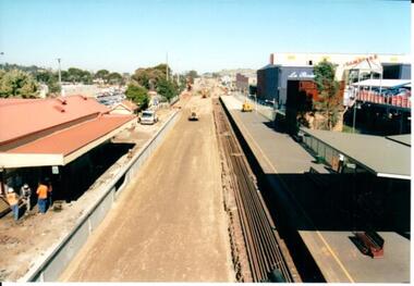
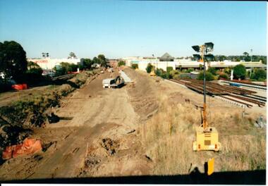 Hume City Civic Collection
Photograph, 21/04/2005
This photograph was taken during the upgrade of the Bendigo Railway line at Sunbury Station. The upgrade of the line took over twelve months to complete and bus services replaced the train service during that time.A coloured photograph of construction on the site of the Sunbury Railway Station. The photograph has been taken from the Macedon Street bridge and is looking south towards Station Street. The old rail tracks have been removed and excavation work is in progress to make way for the new tracks. The new rail lines have been placed on the side of the track on the RHS of the photograph.railways, bendigo line, railway stations, bridges, sunbury railway station, george evans collection -
 Hume City Civic Collection
Photograph, 21/04/2005
This photograph was taken during the upgrade of the Bendigo Railway line at Sunbury Station.A coloured photograph of construction on the site of the Sunbury Railway Station. The rail track has been lowered and the station platform has been narrowed to accommodate the new trains. The former bluestone wall below the platform on the Melbourne side of the station has been replaced by reinforced concrete. The rail lines have been placed along the track on the RHS of the photograph.railways, bendigo line, railway stations, bridges, sunbury railway station, george evans collection -
 Kew Historical Society Inc
Map - Subdivision Plan, Grenville Estate, 1922
Pru Sanderson, in her groundbreaking ‘City of Kew Urban Conservation Study : Volume 2 - Development History’ (1988), summarised the periods of urban development and subdivisions of land in Kew. The periods that she identified included 1845-1880, 1880-1893, 1893-1921, 1921-1933, 1933-1943, and Post-War Development. These periods were selected as they represented periods of rapid growth or decline in urban development. An obvious starting point for Sanderson’s groupings involved population growth and the associated economic cycles. These cycles also highlighted urban expansion onto land that was predominantly rural, although in other cases it represented the decline and breakup of large estates. A number of the plans in the Kew Historical Society’s collection can also be found in other collections, such as those of the State Library of Victoria and the Boroondara Library Service. A number are however unique to the collection.Subdivision plans are historically important documents used as evidence of the growth of suburbs in Australia. They frequently provide information about when the land was sold on which a built structure was subsequently constructed as well as evidence relating to surveyors and real estate and financial agents. The numerous subdivision plans in the Kew Historical Society's collection represent working documents, ranging from the initial sketches made in planning a subdivision to printed plans on which auctioneers or agents listed the prices for which individual lots were sold. In a number of cases, the reverse of a subdivision plan in the collection includes a photograph of a house that was also for sale by the agent. These photographs provide significant heritage information relating house design and decoration, fencing and household gardens.In advertising the twenty-two sites of the Grenville Estate in Cotham Road and Alfred Street, Kew, the auctioneers emphasised the proximity of the development to shops, schools, and churches. That mansions surrounded the Estate was publicised as an added attraction. The plan shows how at this stage A regrettable aspect of this plan is that it is pasted over, and obscures a real estate photograph by the Kew photographer Josiah Earl Barnes.subdivision plans - kew, grenville estate, glenferrie road, alfred street, thomas street, cotham road -
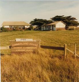 Phillip Island and District Historical Society Inc.
Photograph, John Cook, 1978-79
In 1927 Mr A. K. T. Sambell built a pier, planned and subdivided a residential estate, designed and built Summerland House, where ardent golfers after an enjoyable day on the course, could relax. Summerland House was built by local builder Mr Vic McRae. It attracted large numbers of professional people from Melbourne.Three photographs of Summerland Guesthouse, one of the first Guesthouses on the Island, situated above the site of the Penguin Parade. 81-87 Note sign: Open - overnight accommodation and holiday flats. 81-88 View of Summerland Guesthouse. Probably back view. Note elevated water tank. Car parked behind. 81-89 Another view of Summerland Guesthouse.coloured photograph, summerland guesthouse phillip island, akt sambell -
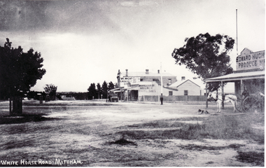 Whitehorse Historical Society Inc.
Photograph, North Corner of Whitehorse & Mitcham Road, Mitcham, c1920's
Black and white photo of the northern cnr Whitehorse and Mitcham Roads, Mitcham, showing Hughs Produce Store, with his white horse and delivery waggon outside. This was later the site of Mirama Court, later to be refurbished as shops and offices.|The vacant land on the far corner became a grocers shop and later the Westpac Bank. It is currently (2005) a computer sales shop.hughes produce store, mitcham road, mitcham, whitehorse road mitcham, mirama court mitcham, westpac bank -
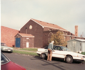 Whitehorse Historical Society Inc.
Photograph, Guide Hall, Mitcham, 13/06/1986 12:00:00 AM
2 Coloured photos of Guide Hall, West side of Brittania Street, Mitcham. Formerly jointly used with Scouts and therefore known as Scout Hall. Since demolished. Guides are now located in a purpose built facility on Halliday Park and Scouts likewise in Brunswick Road. These moves were necessitated by the redevelopment of Britannia Street and the former Primary School site.mitcham guide hall, mitcham scout hall -
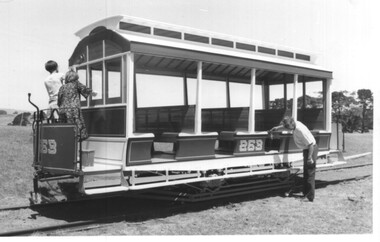
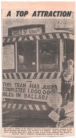 Ballarat Tramway Museum
Newspaper, The Courier Ballarat, "A top attraction", 24/04/1973 12:00:00 AM
Newspaper clipping from The Courier, 24/4/1973 of a photo of tramcar 27 at the Museum site (BTPS) on display with three children at or near the doorway. Tramcar on the dash panel has the sign "This tram has just completed 1,000,000 miles in Ballarat" on the front apron. Captions notes children names as "Louise, Genevieve and David Hanzl" and mentions BTPS as an attraction.date in blue ink of "24/4/73" in top right hand corner of cutting.trams, tramways, btps, museum development, displays -
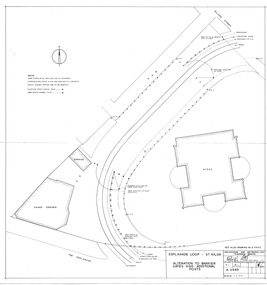 Melbourne Tram Museum
Drawing, Melbourne & Metropolitan Tramways Board (MMTB), "Esplanade loop St Kilda - Alteration to Barrier Gates and Additional Posts", Apr. 1956
Drawing - No. A3549 - titled "Esplanade loop St Kilda - Alteration to Barrier Gates and Additional Posts", shows buildings on the site, Candy corner, Kiosk, tram tracks, proposed fencing and gates, signed by Chief Engineer D Eakins on 30/4/1956. Has a hand date stamp of 7 Apr 1956 on rear noting the date printed.trams, tramways, st kilda, candy corner, turning loops -
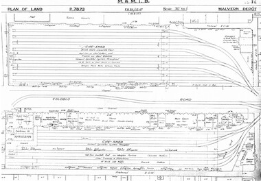 Melbourne Tram Museum
Drawing, Melbourne & Metropolitan Tramways Board (MMTB), "Malvern Depot", c1938
Set of three photocopied plans or drawings on A3 sheets of "Malvern Depot" - 15-3-1937 .1 - P7873 - Plan showing details of car sheds .2 - P7894 - Plan of Land showing overall site plan .3 - P8342 - showing details of buildings, including offices, Club Rooms in Stanhope St, No. 28 Stanhope St and sub-station.trams, tramways, drawings, depots, property, substation, malvern depot -
![Plan, University of Melbourne Burnley Campus Institute of Land and Food Resources Formerly known as the Royal Horticultural Gardens Burnley [sic], 2001](/media/collectors/52f2d90c9821f4163875a333/items/6145823c174069677c22f6e6/item-media/65ef8feeb2201fddf6999498/item-fit-380x285.jpg) University of Melbourne, Burnley Campus Archives
University of Melbourne, Burnley Campus ArchivesPlan, University of Melbourne Burnley Campus Institute of Land and Food Resources Formerly known as the Royal Horticultural Gardens Burnley [sic], 2001
site plan, buildings, planrs -
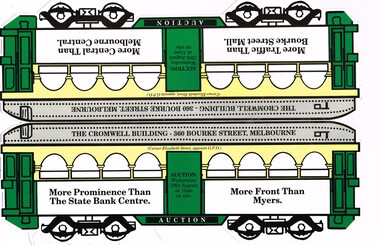 Melbourne Tram Museum
Pamphlet, Alexander Robertson, "The Cromwell Building - Auction", 2009
Pamphlet - folded and cut in the shape of a Melbourne W class tram with arched advertising windows, for the marketing of an auction of "The Cromwell Building" - Wednesday 19 August 2009 (year based on calendar search). Gives details of the building and site, and agent contact details. Has photos of the building on the corner of Elizabeth and Bourke Streets. Agents Alexander Robertson and Colliers Jardine.trams, tramways, auctions, real estate, advertisements, bourke st, elizabeth st -
 Melbourne Tram Museum
Photograph - Set of 2 Black & White Photograph/s, Keith Kings, 2/12/1979 12:00:00 AM
Set of 2 Black and White photographs of the replica Horse Tram 253 at the TMSV Bylands site. .1 - cleaning the tram - missing the end canopies .2 - Interior of the tram Notes on the rear of the tram note the work of the builder - Newton & Gillian Williams of Mildura and Alan Sutcliffe. Dated 2/12/1979. Photo Numbers 180-32 and 180-33Has the Keith Kings photo stamp on the rear, with extensive details of the photograph.trams, tramways, replica, cross bench tram, horse tram, tmsv, bylands, tram 253 -
 Lakes Entrance Regional Historical Society (operating as Lakes Entrance History Centre & Museum)
Photograph, 1997c
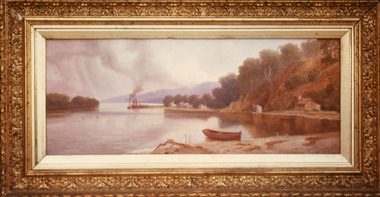
Walter Seehusan, first art teacher at Bairnsdale School of Mines. Painting in possession of St Nicholas Anglican Church, Lakes Entrance, Victoria, bequeathed by Miss E L Phillips. Original painting 1890c.Colour photograph of a painting by W Seehusan of view from site of Kalimna Jetty towards Nungurner, showing mill workers cottages, jetty and steamers at Maringa Creek sawmill. Fisherman's cottage in right foreground, settlement at Maringa Creek, Gippsland Lakes, by mill workers and fishermen. Painting shows denuded cliffs and timber slide. Lakes Entrance Victoriawaterways, boats and boating -
 Bendigo Historical Society Inc.
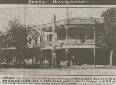
Newspaper - JENNY FOLEY COLLECTION: LAND BILL
Bendigo Advertiser ''The way we were'' from 2000. Land Bill - The main purpose of the Bendigo Land Bill was to authorise the sale of land at the corner of Mitchell and High streets for 9000 Pounds. In 1870 the site was a gold mine on which a Bendigo councillor, Dr Boyd, had erected buildings, one of these buildings was the City Club Hotel. The clip is in a folder.newspaper, bendigo advertiser, the way we were -
 Bendigo Historical Society Inc.
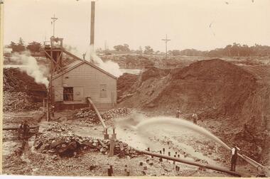
Photograph - AUSTIN COLLECTION: MINE SITE, SLUICING
Black and white photo: image shows mine site, chimney in background, corrugated iron shed in middleground, man operating sluice on bottom RH side. Men inside engine house looking on and two beside sluicing operation RH side. Large pile of sand or mullock on RH side. Mining dam in background, barely visible. Unidentified mine.bendigo, mining, mine site