Showing 10725 items
matching sites
-
 City of Ballarat Libraries
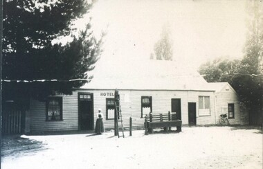
Photograph - Card Box Photographs, White Swan Hotel, Ballarat circa 1870
The site is now the White Swan Reservoir. The person pictured could be the licensee, Mrs Ritchie. white swan hotel, white swan reservoir, building, commerical, hotel, person -
 Melbourne Legacy
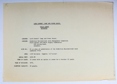
Plan - Document, plans, Lord Somers' Camp and Power House. Gully Lodge, Eppalock
Plans for the permanent camp site used by Melbourne Legacy in the second half of the 20th century.Most of the Junior Legatees would have stayed at Lord Somers' camp, which is still in use.6 photocopied plans and 1 cover sheet - A4 size - black on white, single sided.camp, lord somers camp, power house, eppalock -
 Kyneton RSL Sub Branch
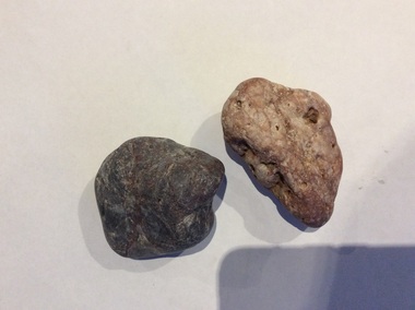
Gallipoli pebbles
The stones are a momento from Anzac Cove, the site of the Australian Infantry Force's landing in 1915.Landing at ANZAC Cove , 25 April 1915 Description As part of the attempt to seize the Gallipoli Peninsula in order to suppress the Turkish defences guarding the Dardanelles, military landings were made at Cape Helles at the southern tip of the peninsula (the main landing) and on the west coast near Ari Burnu. At this secondary objective two Divisions of the Australian and New Zealand Army Corps (ANZAC) landed in the darkness and faced rugged and difficult country. Units mixed up on their arrival rushed inland and became separated from the main force, which came under growing fire from the Turkish defenders. While Turkish reinforcements arrived, the ANZAC position became increasingly precarious as the assaulting force failed to secure their initial objectives. Falling back on improvised and shallow entrenchments the ANZACs held on for a crucial first night. By that first evening 16,000 men had been landed; of those over 2,000 Australians had been killed or wounded. www.awm.gov.au ANZAC Cove landingTwo smooth stones. Both would fit into the palm of a medium sized hand. One is dark, almost black, the other lighter, with a pinkish tinge.Catalogued as 108A and 108 Banzac cove, gallipoli -
 Buninyong & District Historical Society
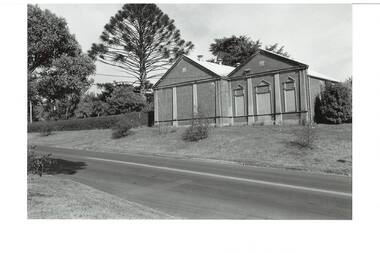
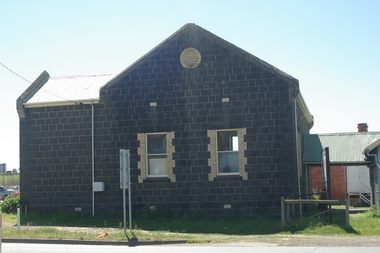
Photograph - B/W photograph, Buninyong Masonic Lodge, 1993
Masonic presence in Buninyong since the nineteenth century, this is the second lodge built on the same site.Early twentieth century public buildingBlack and white photograph of Buninyong Masonic Lodge, a brick building located on the western side of Warrenheip South.buninyong, masonic lodge, building -
 Buninyong & District Historical Society
Photograph - B/W photograph, Buninyong Masonic Lodge, 1993
The Buninyong Masonic Lodge was originaly formed in 1858. This brick building is the second hall on the site.Third oldest Masonic Lodge in Ballarat area, example of C20th public building.Black and White photograph of the Buninyong Masonic Lodge, double-fronted brick building, decorative concrete low-relief pillars, door and windows blocked. Also showing nature strip and roadway in Warrenheip Streetbuninyong, warrenheip st., masons., hall, building, streetscape -
 Glen Eira City Council History and Heritage Collection
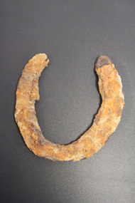
Horseshoe
The horseshoe was found during excavating the site for the development of GESAC, East Boundary Road, Bentleigh. Iron horseshoe, U-shaped, dark and corroded with concretion / accretion of rusty coloured debris over much of the surface.No legible inscriptions. -
 Stawell Historical Society Inc
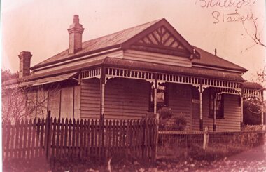
Photograph, "Braeside" Heal Family home in Moonlight Street site now No 45
Home of Heal Family in Moonlight Street site now No 45. Home named Braeside. stawell -
 Lakes Entrance Historical Society
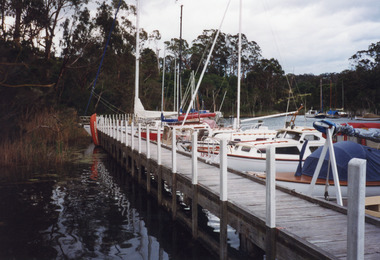
Photograph - Chinaman's Creek, 1999
Site occupied by Chinese fishermen and gardeners late 1800's and early 1900's.Colour photograph of the jetty at Chinaman's Creek showing yachts and launches moored on lake side of jetty, moored yachts visible in distance under timbered bank. Metung Victoriawaterways, jetties, boats and boating -
 Ballarat Tramway Museum
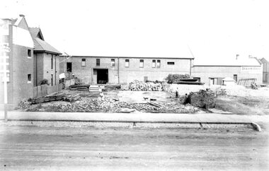
Photograph - Geelong MESCO offices, Melbourne Electric Supply Co. (MESCo), c.1900-10
Site cleared for construction of MESCO offices on SW corner of Yarra and Corio Sts., Geelong.Yields information on early Geelong streetscape and constructionBlack and white print on paper.Plate 2-8 Spare written in ink on the back of the photograph.mesco geelong, corner yarra and corio sts. geelong -
 Darebin Parklands Association
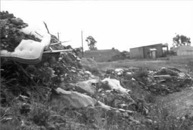
Rockbeare Park 1970s, 1973-1980
This photograph shows an area of the Darebin Parklands that was a tip site before it became part of the park.B&W photograph. Rubbish at the tip. This item and all other Darebin Parklands Association archival material is now held by State Library Victoria (Accession No: YMS 13746). Please contact State Library Victoria if access is required. -
 University of Melbourne, Burnley Campus Archives
Plan, Emerald Environmental Horticulture Annexe VCAH Burnley, 1992-1996
In 2012 was owned by John Rayner who purchased site from The University of Melbourne in c2006.(1) Tracing paper Sketch. Scale 1:500 dated 26.7.96 drawn by JK (Jill Kellow, Staff). (2) Tracing paper and paper copies, "Proposed Location of Toilet Facility and Septic System." Scale 1:500. (3) Tracing paper copy ,"Revegetation Program Works 1993/94." Scale 1:500. (4) Coloured laminated and tracing paper copies, "Proposed Concept Plan for Development." (5) Tracing paper and paper copies of labelled sketch. Scale 1:500. (6) Proposed Development 1994-95 - List of Proposed New Works. (7) Tracing paper and paper copies, Existing Ornamental Plants, Drawing No E1 drawn by J.J.W. 1.8.92. Scale 1:100. (8) Proposed Amenities Block at Lot Charman Ave, Emerald 3782 by Belgraphic. Drawn by Rosemarie, Plan No 93 003 tp March 1993. Scale 1:50. emerald, john rayner, jill kellow, vcah burnley -
 Ballarat Tramway Museum
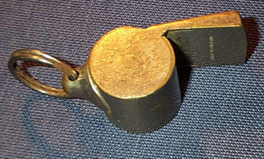
Functional Object - Whistle, J. Hudson and Co. (Whistles) Ltd, c1940?
Metal pea whistle, steel, nickel plated with a spring steel ring. Whistle component made from two stamped and folded pieces of steel plate with a "pea" inside. Spring steel ring held to the whistle with a pressed steel piece. Whole whistle appears to be silver soldered. On the top of the whistle, stamped into the flat plate is the words "The Acme Thunderer" and on the bottom "Made in England". Known by manufacturer as "Small whistle with tapered mouthpiece, produces high pitch". Made by J. Hudson and Co. (Whistles) Ltd. of Birmingham United Kingdom. See Web. site material (attached on file) for details of whistle, history etc. www.acmewhistle.co.uk/history.html Assumed belonged to Les Denmead and was his personal whistle, used by Inspectors. See J. Hudson web site - www.acmewhistles.co.uk (down loaded 10/1/2002)inspectors, whistles, tramways -
 Bendigo Historical Society Inc.
Document - MERLE HALL COLLECTION: CORRESPONDENCE AND DOCUMENTATION RE SITE FOR PERFORMING ARTS CENTRE 1975/76
a. Extensive and detailed correspondence and documentation re site for Performing Arts Centre 1975/76; Letters from City Engineers; Town Clerk; Dr Westbrook (Ministry for the Arts); Drama officer (Ministry for the Arts); includes list in of Arts Council sponsored performances over the period 1971-1975; questionnaire relating to a Cultural & Arts Centre; list of Potential Users of an Art Centre Complex; minutes/correspondence re The Bendigo Urban Renewal Liaison Committee; plans for sites. Would need to be read and examined in its entirety due to complexity of the issue; b. Correspondence between City of Bendigo and Bendigo Arts Council (April 1976); Correspondence between City of Bendigo and Arts Council of Australia (Feb/Mar 1974) with Valuer's Letter and handwritten notes of sub-committee meeting. -
 University of Melbourne, Burnley Campus Archives
Plan, Orchard/Field Station, 1983 - 1992
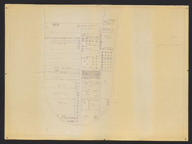
(3) Used by Linda Hipwell for her Honours Thesis.Plans of the Orchard later known as the Field Station. (1) Copy, "Drawing: Orchard Site Plan." Each section labelled. (2)Tracing paper, 2 paper copies and 3 enlargements, "VCAH Burnley Field Station Plan," some printed labelling and some in pencil. 1992.(3) "VCAH Burnley Field Station Proposed Redevelopment," drawn by MG July 1992. (4) Tracing paper copy, Site Plan of Orchard by Alexander Metherell Pty. Ltd. Job No BHC/1 drawing No SP/2 Dec 1983. Scale 1:500. (5) Plan on tracing paper, includes Energy Education Centre. (6) Plan on tracing paper, includes Energy Education Centre. Scale 1:500. Also see B15.0352 Full Report. orchard, field station, linda hipwell, alexander metherell -
 University of Melbourne, Burnley Campus Archives
Plan, Pat de Moulpied, Rose Garden, 1988
Most of these plans were held in Geoff Olive's office. (1) Preliminary concept South-East corner Burnley Gardens Re-design Proposals, Amenity Horticulture III, drawn by Pat de Moulpied 1988. Original turf path destroyed after Garden Week to be replaced with paving donated by Boral. (2) Rose Garden Site Analysis by Peter Jans, Parks & Gardens 1989, pencil on paper. On reverse, "B. Site Analysis & Design Changes. (3) 2 copies pencil on tracing paper, Planting plan. (4) Planting plan on tracing paper. (5) Planting plan (roughly final version?), 1 tracing paper, 6 photocopies. (6) Notes from Geoff Olive addressed to James Hitchmough. Also photocopies of 1 - 5 and some rough sketches. Notes made by Guide Jean Corbett on the History of the Rose.pat de moulpied, peter jans, gardens, geoff olive, andrew smith -
 Greensborough Historical Society
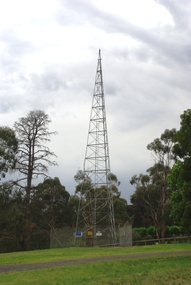
Photograph - Digital Image, Marilyn Smith, Air Navigation Facility, Montmorency, 2018. Tower, 04/12/2018
Air Navigation Facility, Palara Court Montmorency, is made up of a tower and brick building surrounded by wire fences. It is sited in parkland at the end of Palara Court close to the Plenty River Trail. Warning signs are placed on the fences, including: "This facility is provided for the control and guidance of aircraft". This photograph shows the tower on the site.Digital copy of colour photographsair navigation facility, air control, palara court montmorency -
 Greensborough Historical Society
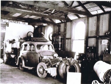
Photograph - Digital image, Stubley Garage - Interior View 1946, 1946_
Interior view of Stubley Motors 1946. The Stubley Group began in 1946 when Purcell Stubley purchased a site with petrol bowsers in Main Street from 'Snowy' Jessop. In 1948 Purcell began building the new Stubley Motors, working round the old site to keep the business operating. It was completed in 1951.Digital copy of black and white photographpurcell stubley, stubley motors -
 Greensborough Historical Society
Photograph - Digital image, Stubley Garage - Interior View 1946, 1946_
Interior view of Stubley Motors 1946. The Stubley Group began in 1946 when Purcell Stubley purchased a site with petrol bowsers in Main Street from 'Snowy' Jessop. In 1948 Purcell began building the new Stubley Motors, working round the old site to keep the business operating. It was completed in 1951.Digital copy of black and white photographpurcell stubley, stubley motors, stubley group greensborough -
 Greensborough Historical Society
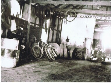
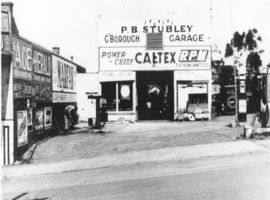
Photograph - Digital Image, Stubley Garage, 1946_
Stubley Garage 1946. The Stubley Group began in 1946 when Purcell Stubley purchased a site with petrol bowsers at 96-104 Main Street from 'Snowy' Jessop. In 1948 Purcell began building the new Stubley Motors, working round the old site to keep the business operating. It was completed in 1951.Digital copy of black and white photographpurcell stubley, stubley motors, stubley group greensborough -
 Hume City Civic Collection
Photograph, late 1990s
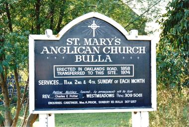
St. Mary's Anglican Church at Bulla was originally built on the outskirts of Bulla township in 1858. In the early 1970s it was moved to its present site to make way for the flight path at the newly constructed Tullamarine Airport. The former site was on the corner of Oaklands and Sunbury Roads and is covered with vegetation. The church was designed by Thomas Taylor.A coloured photograph of the board which is along the fence line outside St. Mary's Church at Bulla. The white writing is on a navy blue background and is framed in white. The notice gives details of services, clergy and caretaker.churches, religion, anglican church, taylor, thomas, potter, charles e. rev., prior, a., st. mary's anglican church, george evans collection -
 Hume City Civic Collection
Photograph, late 1990s
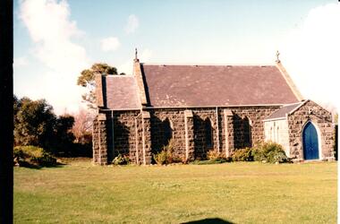
St. Mary's Anglican Church at Bulla was originally built on the outskirts of Bulla township in 1858. In the early 1970s it was moved to its present site to make way for the flight path at the newly constructed Tullamarine Airport. The former site was on the corner of Oaklands and Sunbury Roads and is covered with vegetation. The church was designed by Thomas Taylor.A profile view of the west side of St. Mary's Anglican Church at Bulla and the garden area around the church. A slate covered gable roof has been constructed over the porch nave and chancery with a cross at each end of the roof over the nave. 6 bluestone buttresses and 3 lance windows are along the side with 3 small lancet windows and a blue painted wooden lancet door on the porch.churches, religion, taylor, thomas, st. mary's anglican church, george evans collection -
 Bendigo Historical Society Inc.
Document - MCCOLL, RANKIN AND STANISTREET COLLECTION: INDENTURE BETWEEN KING EDWARD VIII AND MONUMENT HILL CONSOLIDATED MINE, 2/09/1936
Indenture document number 10878, Vol 317 Folio 35044. Foolscap 4 pages including a map, dated 2nd September, 1936, between King Edward VIII (Crown land) and Monument Hill Consolidated (Bendigo) No Liability 'carrying on operations in the Parish of Sandhurst, to occupy and use the land demised as a site for machinery buildings and offices to be used in connexion with 'mining purposes' ' Document signed by Right Hon William Charles Arcedeckne, (Baron Huntingfield) and J. Stanistreet, Manager, affixed with the Common Seal of Monument Hill Consolidated (Bendigo) No Liability. Map drawn on dark buff paper, and fixed to document. Map shows lease 10878 in the Mining District of Bendigo, Parish of Sandhurst, County of Bendigo. N.Area 2.2.24 ( 2 acres, 2 roods, 24 perches ) Lease site on Rowan Street, bordered by Ophir Street. Coloured in purple on plan with small red area. On bottom: ' Note Red Areas Excised. Scale 4 chains to 1 inch, M.M. Var. 8 degrees 32' E. On lease site, New Chum Gully marked, W.B. House, and Permanent Occy. marked on red area. On last page ownership of lease details from 1937 to 1942.bendigo, mining, monument hill consolidated, common seal of monument hill consolidated, nell gwynne mine, south nell gwynne gold mining company, bendigo mine, ophir street, rowan street, mackenzie street.indenture vol 317 fol. 35044. j stanistreet. -
 Eltham District Historical Society Inc
Document - Series Listing, Fraser Faithfull et al, Series 21: Eltham Library construction, 300 photographs, sketch plans, 2000
Series consists of I) 7 sepia toned photographs or Librarian Linda McConnell inspecting work on the site orthe new library. 2) 11 B& W, sepia and colour photographs or work on the site. 3) 3 laminated colour sketches: floor plan, roor plan & exterior 4) A set or approximately 280 colour snapshots documenting work on the construction site, arranged chronologically month-by-month. There are also 5 "panorama" panels or between 2-4 snapshots taped together. These have been mounted on acid-free card.shire of eltham archives, series listing -
 Whitehorse Historical Society Inc.
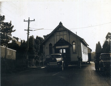
Photograph, Methodist Church Mitcham, 1/06/1967 12:00:00 AM
1888 First Wesleyan church erected on the East corner of Richards St and Whitehorse Rd. 1021 Church was transferred and enlarged on Mitcham Rd. site. 1932 Church was extended Westward. Kindergarten room was extended east to form Wesley Hall. 1953 Church connected to Wesley Hall. 1957 house next to Church purchased. 1958 Community Hall opened. Presbyterian site used by both denominations. 1967 old Methodist site closes, Church building and Wesley hall transferred to Doncaster East and these photos show the Church being moved.Church being moved to Doncaster East. Man on the roof lifting power linesmethodist church mitcham, churches -
 Vision Australia
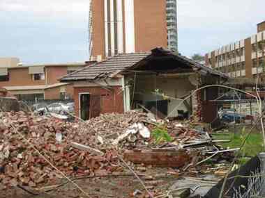
Photograph - Image, Demolition of Raleigh Street premises, 200
On September 23, 1925 the State Goverment gazetted a transfer of land in Raleigh Street, Prahran to RVIB. This was used to establish a hostel for women apprentices and workers, and building commenced in 1926 and was completed in 1927, at a cost of 3500 pounds. Demand for accommodation was strong and in 1929 a hostel for men was completed. The building were used as hostels for many years, but as demand decreased, the Institution found other ways to utilise the buildings. In 1972, a plant nursery was established on the site and other departments temporarily used the site. In 1994 the Employment Services team moved out of the building and the site was sold to developers.17 col. images of the partially demolished house at Raleigh Street, Prahranroyal victorian institute for the blind, raleigh street hostel -
 Eltham District Historical Society Inc
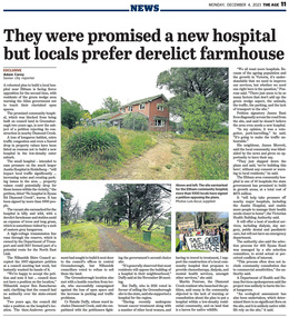
Newspaper - News Clipping, Adam Carey, They were promised a new hospital, but locals prefer derelict farmhouse, The Age, December 4, p11, 2023
The Age, Monday, December 4, 2023, p11 Article about local protest at Victorian Government decision to build a community hospital on the site of an old derleict farmhouse owned by the Department of Transport at 405 Ryans Road, Diamond Creek. The site was until 2017 part of a potential route fior the North East Link.community hospital, cr. ben ramcharan, cr. natalie duffy, department of ttransport, diamond creek, eltham community hospital, james bant, james merrett, martin penrose, north east link, petition, protest, ryans road -
Federation University Historical Collection
Document, Allum Lovell, Former Ballarat Brewery Conservation Analsysis, c1990
Carlton and United Breweries purchased the Ballarat Brewering Company Limited site in 1958, including its chain of 114 hotels. In the mid 1980s CUB transferred the production of Blalarat Bertie to the Abbotsford plants and started producing Guimes under license in the Ballarat plant. On 30 June 1989 CUB closed the Ballarat site.Report conducted by Allum Lovell for the Ballarat School of Mines. former ballarat brewery, conservation management plan, james coglan, william kenna, tulluch and mclaren, phoenix brewery, chimney, brew tower, cooling tower, carlton and united breweries, brewery building -
 Greensborough Historical Society
Photograph - Digital Image, Marilyn Smith, Mernda Mechanics Institute 2018, 27/09/2018
In 2018 GHS members visited Turner's Bakery in Mernda for lunch and continued on to visit historic sites remaining in the Mernda area. This photograph shows the Mernda Mechanics Institute, established 1888. It was sited to the rear of the Bridge Inn Hotel on land donated by the hotel's owner. Today the Mechanic's institute is a small hall available to rent.Mernda is an area of rapid modern growth with a few remaining historic buildings dating from the 19th century.Digital copy of colour photographsmernda, mernda historic sites, mernda mechanics institute, mechanics institutes victoria, bridge inn hotel mernda -
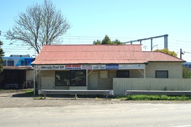 Greensborough Historical Society
Photograph - Digital Image, Mernda Post Office 2018, 25/07/2019
In 2018 GHS members visited Turner's Bakery in Mernda for lunch and continued on to visit historic sites remaining in the Mernda area. This photograph shows the Mernda Post Office, formerly the Mernda General Store. It is sited in Schotters Road. Today the Post Office has been relocated to modern premises in Mernda Village Drive.Mernda is an area of rapid modern growth with a few remaining historic buildings dating from the 19th century.Digital copy of colour photographmernda, mernda historic sites, mernda post office, schotters road mernda, post offices, mernda general store -
 Greensborough Historical Society
Photograph - Digital image, Purcell Stubley and staff, 1970s
Purcell Stubley with staff from Stubley Motors. The Stubley Group began in 1946 when Purcell Stubley purchased a site with petrol bowsers in Main Street from 'Snowy' Jessop. In 1948 Purcell began building the new Stubley Motors, working round the old site to keep the business operating. It was completed in 1951.Digital copy of black and white photographpurcell stubley, stubley motors