Showing 1506 items matching "acres"
-
 Bendigo Historical Society Inc.
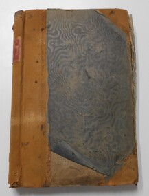
Document - LANDS OFFICE - CROWN LANDS SURVEYED AND SOLD - INDEX, 26.1.1857 - 1871
Document: hard cover journal, faded dark green cover with brown corners and spine. 193 pages filled out - LH page: Parish, town lands, suburban lands, country lands, total lands surveyed, date of survey RH page: date of sale, by auction, by selection, price per acre, total amount, name of purchaser. On spine ' 01, index book O'.Lands Officelands office, bendigo, sandhurst, crown lands sold, rural land. -
 Whitehorse Historical Society Inc.
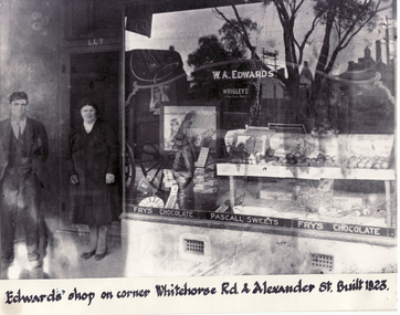
Photograph - Black and white photograph, Edwards Shop Mitcham, c1923
Black and white photo of Edwards Shop on cnr Whitehorse Road and Alexander Street, Mitcham. Built 1923. Mr. Edwards bought 5 acres running from Whitehorse Road to Victoria Street Mitcham in 1915 for 118 pounds. Alexander Street was surveyed in 1949 later. originally accommodating a mixed business and later the local Mitcham newspaper. It currently houses a take-away food shop.edwards, william alexander -
 Bendigo Historical Society Inc.
Document - SONOGNINI MINING LEASE
Mining lease between Leno Sonognini of Victoria Street Eaglehawk, Miner and Giovanni Sonognini. Three acres, three roods 9 perches with a mining dam. On lease document: Leno Sonognini ..... Is now the proprietor of the within described lease by transfer from the within named Giovanni Sonognini' Dated '10th day of February 1898 at 12.20 in the afternoon and numbered 60701 Mining lease No 5956'.bendigo, mining, lease 5956, eaglehawk -
 Ringwood and District Historical Society
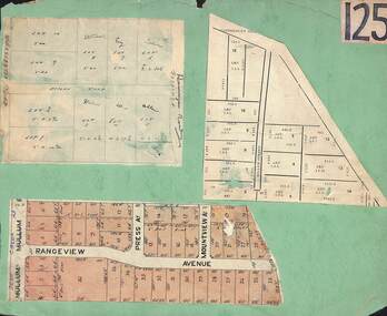
Card, Collage of Residential Subdivision Map Clippings - Ringwood, Victoria - (Undated)
Three maps mounted on green cardboard - Hand-drawn map of residential allotments off Warrandyte Road in Milne Road and Berringa Road Park Orchards. Map with acres roods and perches measurements of allotments in Canterbury Road and Miller Street Heathmont. Clipping from a land sale brochure with street names not existing together in the area - Rangeview Avenue, Press Avenue and Mountview Avenue. -
 Orbost & District Historical Society
assessment notices, 1913 1914 1926
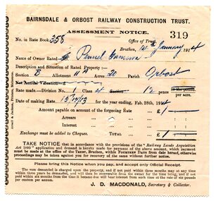
In the Orbost area a committee was formed called the Bairnsdale to Orbost Railway Trust. The business of the trust was to acquire the land necessary for the railway and levy a rate on the property owners. The other cost to the area wanting a railway was the guarantee against loss in working expenses of the railway, the Orbost Shire had to provide up to £3000 per annum. Even as late as 1913 the railway was still expected to go through Orbost and beyond. 635.3 is to Albert Trewin for 158 acres at Orbost. 635.2 is to Robert P. Cameron for 120 acres in Orbost and 635.1 is for Penuel Cameron for 20 acres in Orbost. Robert Pullar Cameron was a Shire Councillor for many years. He married Penuel Hossack and had a family of James, Flora, Penuel and Alex. Albert and Hazel Trewin farmed at Jarrahmond, just outside Orbost on the B Road. This item is associated with the history of the Orbost-Bairnsdale railway line and therefore reflects the role that the rail line played in the social and economic history of Orbost.Three paper notices of assessment. 635.1 is white with black print. 635.2 and 635.3 are pink with black print. All have hand-written details. They are from the Bairnsdale and Orbost Railway Trust.orbost-bairnsdale-railway cameron-robert-pullar trewin-albert assessment-notices -
 Federation University Historical Collection
Document, Ballarat Junior Technical School Nerrina Pine Plantation, 1957
The Ballarat Junior Technical School Pine plantation was a 32 acre sight at Nerrina wehre several thousands of pine trees were planted over three years. Information from the Victorian Education Department in regards to the Ballarat Junior Technical School Pine Plantation. Also includes newspaper articles on the Nerrina Pine Plantation. A letter was addressed t o teh Old Boys Association, Junior Technical School, amd addressed the question of a subsidy for fencing.ballarat junior technical school, pine plantation, endwoment plantation -
 Tatura Irrigation & Wartime Camps Museum
Water Meter, 1980+
This type of meter replaced earlier models with registered acre feet (now megalitres). approx 1980. Meters on wheels have been used for approx 80 yearsMeter for attachment to dethridge wheel to measure megalitres of water. This type attached to the wheel and revolves with it. (Older type attached to the axle) This one is for a large wheel.S.R.W.S.C M.L L.M.O I.D. No-MD070942irrgation, dethridge wheel -
 Kiewa Valley Historical Society
Photo - School Children Tawonga Primary School, Circa 1920 (estimate)
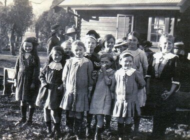
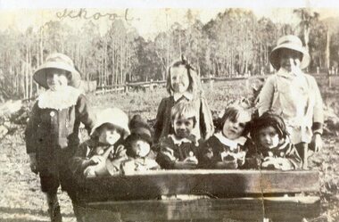
Tawonga is in the Kiewa Valley, where local farmers lived with their families. The school was originally opened July 27 1880, situated on 8 acres near the current township of Tawonga. The school was erased by fire in 1900 and all records destroyed. The school was then moved to the Old Tawonga Hall. In 1910, the school was shifted to its present site on 3 acres of land donated by Frank Cooper. The school building and attendance continued to grow, especially during construction of the Kiewa Hydro Electric Scheme.Tawonga Primary School has educated the local farming and town children for many years. It is an excellent source of the names of the local families of the time ie: Vera Ryder – front row, far right (little girl with the wide headband.)Copy of black and white photograph of pupils at Tawonga Primary School. Circa 1920 (estimate)tawonga primary school, kiewa valley -
 Kiewa Valley Historical Society
Photo - School Children Tawonga Primary School, Circa 1920 (estimate)
Tawonga is in the Kiewa Valley, where local farmers lived with their families. The school was originally opened July 27 1880, situated on 8 acres near the current township of Tawonga. The school was erased by fire in 1900 and all records destroyed. The school was then moved to the Old Tawonga Hall. In 1910, the school was shifted to its present site on 3 acres of land donated by Frank Cooper. The school building and attendance continued to grow, especially during construction of the Kiewa Hydro Electric Scheme.Tawonga Primary School has educated the local farming and town children for many years. It is an excellent source of the names of the local families of the time. Copy of black and white photograph of pupils at Tawonga Primary School. Circa 1920 (estimate)tawonga primary school, kiewa valley -
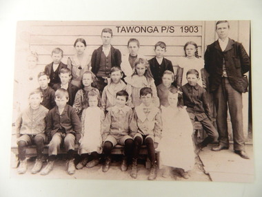 Kiewa Valley Historical Society
Photo - Copy of Tawonga Primary School 1903, Tawonga Primary School, 1903 - original
Tawonga is in the Kiewa Valley where farmers lived with their families. The school was opened on 27th July 1880 situated on 8 acres near the current township of Tawonga. This school was erased by fire in 1900 and all records were destroyed. The school then moved to the old Tawonga Hall. In 1910 the school was shifted to its present site on 3 acres of land donated by Frank Cooper. The school building and attendance continued to grow especially during the construction of the Kiewa Hydro Electric Scheme. Historic: Tawonga Primary school has educated the local farming and town children for many years. It is an excellent source of the names of the local families in 1903. The photo is taken outside the Old Tawonga hall where the school was situated in 1903 and shows the clothing worn by children and teachers at the time.Teacher and 20 students in school photo. "Tawonga Primary School 1903" added digitally when the photo was copied. There is a typed list of all names.Names of students. Back Row: Charlotte Cooper, John Cooper, Ada Cooper, Thomas Hollands, Irene Roper, Stewart Hollands, Lily Barnette. Teacher Donald Mc Cance. Centre Row: Edward Trebilcock, Alfred Hollands, Pearl Barnette, Frank Cooper, Nellie Higginson, Bert Roper, Reg Roper. Front Row: Ben Cooper, Raymond Cooper, Myrtle Barnette, Lewis Crotty, John Creamer, Annie Hollandstawonga primary school. education. kiewa valley. cooper family -
 Ringwood and District Historical Society
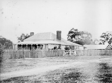
Photograph, Early Heathmont pioneer Mr. Pett in later life about 1900
Black and white photograph (2 copies)Typed below photograph: "Mr. Pett in later life about 1900. An early pioneer of Heathmont. Owned 80 acres south of the intersection of Bedford and Canterbury Roads". Written on rear of backing sheet, "Pett sold his land to Tommy Bent the land speculator". -
 Greensborough Historical Society
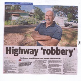
Newspaper Clipping, Diamond Valley Leader, Highway 'robbery', 07/03/2018
A couple believe they're being robbed by VicRoads after they were offered a measly $200,000 for their house and half an acre (0.202ha) of land in Plenty for the Yan Yean Road duplication.News article 1 page, black text and colour image .vicroads, yan yean road, publicly acquired, joe miraglia -
Whitehorse Historical Society Inc.
Document, 10 Gordon Crescent, Blackburn, June 2024
The early history of Gordon Crescent, Blackburn5 pages A4non-fictionThe early history of Gordon Crescent, Blackburngordon crescent blackburn no 10, freehold investment and banking company of australia ltd, clarke arthur e. -
 Linton and District Historical Society Inc
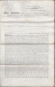
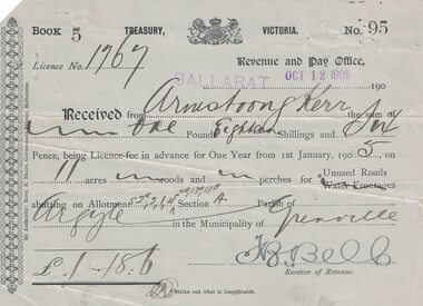
Receipt, Robert S. Brain - Government Printer, Melbourne, Ballarat Revenue and Pay Office, Victorian Treasury, 1906, October 12 1906
Payment for permit to use 11 acres of unused road in Parish of Argyle - Shire of Grenville. Payment of one pound, eighteen shillings and sixpence, received from Armstrong Kerr.Small blue receipt - Treasury, Victoria. Monies received from Armstrong Kerr. Receipt number 95, from Book 5. Licence No. 1767. Receipt signed by J.B. (?) Bell, Receiver of Revenue.armstrong kerr, lease of unused roads -
 Bendigo Historical Society Inc.
Document - STATE RIVERS AND WATER SUPPLY COMMISSION : THE COLIBAN SYSTEM OF WATERWORKS, July
Document titled State Rivers and Water Supply Commission: The Coliban System of Waterworks. Two typed foolscap pages. Three copies of this document - one with measurements in acre-feet, has 'seen July 1971' written in pencil on the top right corner. The other two copies appear to have been updated to convey information in mega litres. Subheadings: History, Development of main storages, Facts and figures, Headworks.state infrastructure, water supply, coliban system, state rivers and water supply commission. coliban system. -
Bendigo Historical Society Inc.
Map - CAMPBELL COLLECTION: BENDIGO AND DISTRICT MAPS
Map. Eppalock, Sedgwick and Strathfieldsaye, scale 20 chains to 1 inch. Road to Bendigo 13 1/2 miles at top right of map, Longlea Railway Station 5 1/2 miles, Bendigo 11 miles, Strathfieldsaye 5 miles on left of map. Total area 3972 acres. Prepared in W.P.B. from Assessment Plan and Parish Plans. H.A. Darby 14-6-29.H.A.Darbymap, bendigo, agricultural lands -
Whitehorse Historical Society Inc.
Document, Walker Estate Mitcham, 8/10/1938 12:00:00 AM
Auction brochure for 'Beautiful brick residence' of 9 rooms, with 1 1/2 acres of grounds, subdivided into 12 sites for brick residences, Saturday 8th October 1938.Auction brochure for 'Beautiful brick residence' of 9 rooms, with 1 1/2 acres of grounds, subdivided into 12 sites for brick residences, Saturday 8th October 1938, by order of the Executors of the late E. E. Walker. Frontages to Mitcham Road, Agra Street, Simla Street and Meerut Street. Auctioneers: Edward Haughton Pty Ltd and Drake & Co. Original copy framed, located in Map Drawer.Auction brochure for 'Beautiful brick residence' of 9 rooms, with 1 1/2 acres of grounds, subdivided into 12 sites for brick residences, Saturday 8th October 1938.walker, edgar edwardes, walker estate, mitcham road, mitcham, agra street mitcham, simla street mitcham, meerut street mitcham, drake & co., edward haughton pty ltd -
Bendigo Historical Society Inc.
Book - Nanga Gnulle - A Memoir by Robin Green, 2022
Soft cover book of 124 pages entitled Nanga Gnulle a Memoir. Colour sketch of the house by Stan Thomas on the front cover. An introduction by Mike Butcher on the back cover. The development of Nanga Gnulle, a mud brick home on several acres, is described and illustrated with numerous B&W and colour photos. Published by R.E. and M.L. Green, 9 Golden Glade, Strathdale, 3550 in 2022 Printed in Bendigo by Bart'n'Print. M & J Qualtrough sticker on title page. bendigo architecture, nanga gnulle -
 Bendigo Historical Society Inc.
Document - NEVILLE KING COLLECTION: OCCUPATION CERTIFICATE HOMESTEAD FARM NO. 15/939 IN THE NAME OF DAVID WILLIAMS AT A COST OF ONE POUND, DATED 25 SEPTEMBER 1897, 1897
Under the Western Australia 'the Homestead act 1893' an Occupation Certificate, Homestead Farm No. 15/939 for David Williams of Bendigo for 160 acres (near Woolkabunning near Bunbury WA); at a cost of one pound. Signed by order of the Commissioner of Crown Lands. Dated 25 September 1897. The land is marked and distinguished in the maps and books of the Department of Lands and Surveys of the said (WA) Colony as Williams Location No. 702. -
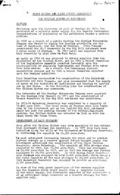
 Kew Historical Society Inc
Photograph, Garden of 'Rockingham', Kew, c.1870
Built by John Bournane, Rockingham had a number of occupants before the newspaper magnate David Syme purchased it in 1902. The house in the 1860s and ‘70s was comprised of nine rooms, and was surrounded by a veranda on the front and sides. It was approached from the Kew road by the curve in front of the Hon. S.G. Henty’s mansion of ‘Findon’.In 1955, the Syme family sold Rockingham to the Red Cross Society to be used as a convalescent home for returned servicemen. The house was sold, demolished, and the land subdivided in 1966.An early panoramic photograph of an early Kew mansion (now demolished), dating from the 1870s.A rare, panoramic photograph (c.1870) of the garden of ‘Rockingham’, during the occupation of the house by W. Gardiner Esq. Rockingham was located beside and above the Barkers Road cutting. The view of the garden in the photograph is of the terraces leading down to the Yarra River. At the time the photograph was taken, the property covered an area of “…nine acres of beautifully laid-out grounds, interspersed with numerous terraces leading down the sloping bank of the river”.rockingham, david syme, kew -
 Bendigo Historical Society Inc.
Document - LANDS OFFICE - CROWN LANDS SURVEYED AND SOLD SANDHURST - 1857 - 1879, 1857 - 1879
Journal: black hard cover with buff spine and corners. Contains details of crown land surveyed and sold, district of Sandhurst. Double pages numbered on top right, page columns - parish, town lands, particulars, survey fees, date of survey, date of sale, auction, selection price per acre, total amount, purchaser. No index. On spine '08' 'Bendigo A' 26th June 1857 to 1879 (?)Lands Officeplace, land sales, lands office, crown land, land surveys, bendigo, sandhurst -
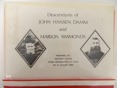 Kiewa Valley Historical Society
Folder - Family History, Descendants of John Hansen Damm and Marion Simmonds. Multiple copies, 1989
John and Marion Damm (nee Simmonds) selected 317 acres of land at Gundowring in 1873. They lived there until 1902. Left for 4 years before returning to the Kiewa Valley in 1906.The Damm family is a pioneer family of the Kiewa Valley.Plastic red cover with transparent front held by 2 gold metal slide clips. 10 clear plastic sleeves holding a brief history, family tree, 4 typed pages, 5 handwritten pages, 4 typed pages - family of John Damm Jnr and handwritten pages - family of John Damm Jnr.damm family; simmonds family; kiewa valley; -
 Whitehorse Historical Society Inc.
Document, David Boyle, 2024
David Boyle purchased land in Nunawading which he occupied in 1868non-fictionDavid Boyle purchased land in Nunawading which he occupied in 1868boyle david, nunawading, pioneers, horticulture -
 Stawell Historical Society Inc
Photograph, Concongella Home Station 1866
Concongella Home Station. Part of a collection of Photographs by Mr. O.G. Armstrong as commissioned by the Shire of Stawell for the Inter-colonial and Paris Exhibition in Melbourne in 1866. The Concongella Station consisted of 57,000 acres along the Concongella Creek. It was first part of Allanvale, taken up by John Allan in 1841. Allen's right to the 137,000 acres of Allanvale was contested and as a result, the northern section of 57,000 acres was renamed Concongella. Concongella Run, with the homestead on the creek of the same name just east of Stawell, occupied the lands between the later named Deep Lead and Great Western. It was on this station that William McLaughlin a sheep minder discovered gold at Pleasant Creek in 1853. Doctor Blundell held Concongella under licence at this time and through until 1858. The homestead has been gone for many years and only some lonely graves remain at this vicinity. stawell -
 Ringwood and District Historical Society
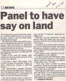
Newspaper, Scrapbook Clipping, Library Collection, Ringwood, Victoria
Newspaper Clipping from "The Mail", 3-10-95. P23. By Andrew Meath. Panel to have Say on LandAn independent panel will decide whether a housing subdivision in an environmentally sensitive part of North Ringwood should proceed. The Ministry of Planning and Development will appoint the panel to consider a request from developers of Barnsdale Forest to divide one acre (0.4 hectares) parcels of land into 7 lots -
 Kiewa Valley Historical Society
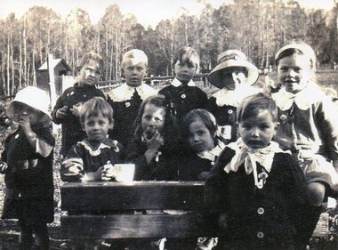
Photo - Tawonga Primary School pupils 1920, 1920
Tawonga Primary School Children 1920. Tawonga is in the Kiewa Valley where farmers lived with their families. The school was opened on 27th July 1880 situated on 8 acres near the current township of Tawonga. This school was erased by fire in 1900 and all records were destroyed. The school then moved to the old Tawonga Hall. In 1910 the school was shifted to its present site on 3 acres of land donated by Frank Cooper. The school building and attendance continued to grow especially during the construction of the Kiewa Hydro Electric Scheme. Early residents of the area. Ellie Seymour front row first on left. Walter J E Ryder in front of the desk at right. Vera Ryder behind him on the right. The boys also wore white collarsCopy of black and white photograph of pupils (children) at Tawonga Primary School 1920tawonga primary school, state school, kiewa valley -
 Eltham District Historical Society Inc
Photograph, W.G. Gray with trees from Kinglake, 1918c
W.G (William George) Gray, owner of Allwood Nurseries in Hurstbridge, with horses and cart laden with trees from Kinglake from where he also had a property raising stock. Shire of Eltham Councillor Gray donated English oak and oriental trees for the Anzac avenue at Hurstbridge planted in 1918. In 1922 he operated a well cultivated property of 64 cleared acres, 56 of which were under nursery healthy stock, principally apples, peaches, plums and cherries. In addition to 4 acres of potatoes. This photo forms part of a collection of photographs gathered by the Shire of Eltham for their centenary project book, "Pioneers and Painters: 100 years of the Shire of Eltham" by Alan Marshall (1971). The collection of over 500 images is held in partnership between Eltham District Historical Society and Yarra Plenty Regional Library (Eltham Library) and is now formally known as 'The Shire of Eltham Pioneers Photograph Collection.' It is significant in being the first community sourced collection representing the places and people of the Shire's first one hundred years.Digital imagesepp, shire of eltham pioneers photograph collection, hurstbridge, william george gray, kinglake, horse-drawn vehicle, trees -
 Lorne Historical Society
Map, F W Niven Lithos, The Mountjoy Lorne Estate, 1889
In 1888 a company was formed to acquire and subdivide the land of the Mountjoy Brothers. The land totaled 197 acres and included Erskine House. The land colored red was that of the Mountjoys. The subdivision map was printed in 1889A paper map of the Mountjoy Estate Lorne , showing allotments, with their owners, and naming land use. It has four black and white line drawings , Erskine House, Mountain View’s, the Rapids, Erskine House sea view and Erskine Falls. The map is largely black and white with red and blue colouring. The map is mstuck to brown paper. lorne, subdivision map, erskine house, mountjoy brothers, -
Bendigo Historical Society Inc.
Document - Presentation, abt1998
Strathfieldsaye State School (SS 1211) began in the Shire Hall in March 1873. Five acres was gazetted in January 1874 and a three roomed, weatherboard school building opened in January 1875.Photo copied hand written notes on the history of the Strathfieldsaye Primary School - "Back To Celebrations" A typed A4 sheet outlining the history and also a photo of the school. Notes from a presentation by Mr Alf Ryall.history, bendigo, strathfieldaye primary school, alf ryall -
Bendigo Historical Society Inc.
Programme - 125th Anniversary, March 1998
Strathfieldsaye State School (SS 1211) began in the Shire Hall in March 1873. Five acres was gazetted in January 1874 and a three roomed, weatherboard school building opened in January 1875.Stathfieldsaye Primary School 125th Anniversary programme and tour guide. 1873 to 1998. The six pages includes a song called Pathways to the future by Gail Godber; a programme; history of the school and a plan of the school.history, bendigo, strathfieldaye primary school, back to celebrations 125th anniversary, gail godber