Showing 324 items
matching barkers road, kew
-
 Federation University Historical Collection
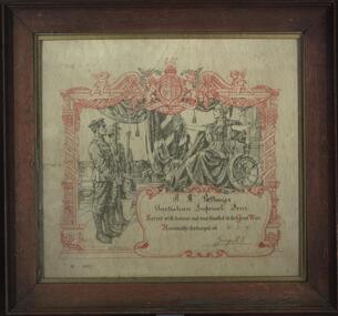
Certificate, Returned Soldier Certificate for Rupert Henry Pottinger, 30/03/1919
R.H. Pottinger served with the Australian Imperial Force during World War One. Framed certificate of discharge made out to R.H. Pottinger, and signed by George R. J. Rupert was born in Sydney the son of Henry Pottenger of 'Ripley' 11 Cotham Road, Kew. Rupert Pottenger served with the 2nd Field Company Engineers. On 03 August 1818 he was awarded the Military Medal. Rupert Pottinger's service number was no. 29. He served in Galipolli and France. V4075r. pottenger, world war one, australian imperial force, rupert pottenger, kew, bernard partridge, beaments art gallery, rupert pottinger, rupert henry pottinger -
 Kew Historical Society Inc
Plan, Borough of Kew Detail Plan No.1577, 1904
The Melbourne and Metropolitan Board of Works (MMBW) plans were produced from the 1890s to the 1950s. They were crucial to the design and development of Melbourne's sewerage and drainage system. The plans, at a scale of 40 feet to 1 inch (1:480), provide a detailed historical record of Melbourne streetscapes and environmental features. Each plan covers one or two street blocks (roughly six streets), showing details of buildings, including garden layouts and ownership boundaries, and features such as laneways, drains, bridges, parks, municipal boundaries and other prominent landmarks as they existed at the time each plan was produced. (Source: State Library of Victoria)This plan forms part of a large group of MMBW plans and maps that was donated to the Society by the Mr Poulter, City Engineer of the City of Kew in 1989. Within this collection, thirty-five hand-coloured plans, backed with linen, are of statewide significance as they include annotations that provide details of construction materials used in buildings in the first decade of the 20th century as well as additional information about land ownership and usage. The copies in the Public Record Office Victoria and the State Library of Victoria are monochrome versions which do not denote building materials so that the maps in this collection are invaluable and unique tools for researchers and heritage consultants. A number of the plans are not held in the collection of the State Library of Victoria so they have the additional attribute of rarity.Original survey plan, issued by the MMBW to a contractor with responsibility for constructing sewers in the area identified on the plan within the Borough of Kew. The plan was at some stage hand-coloured, possibly by the contractor, but more likely by officers working in the Engineering Department of the Borough and later Town, then City of Kew. The hand-coloured sections of buildings on the plan were used to denote masonry or brick constructions (pink), weatherboard constructions (yellow), and public buildings (grey). MMBW Plan No.1577 includes some of the most significant houses in Kew: Herbert Henty’s ‘Roxeth’ (now part of Trinity Grammar), ‘Butleigh Wooton’, ‘Bokara’ and ‘Harrow’. It also includes the streets that have since changed their names. That part of College Parade linked to Glenferrie Road is now named College Place, College Parade now extends further north, and Charles Street did not yet reach Barkers Road. Roxeth is one of a number of Henty houses in Kew. Herbert Henty made his home here and was elected a member of Kew Municipal Council in 1864 and mayor in 1868-69. Walter Henry Serle, of Harrow served in the First World War. He was awarded the Military Medal ‘’For conspicuous bravery and devotion to duty. On 29th September near BELLICOURT he showed the greatest bravery and determination when his platoon was attacked by enemy bombing parties. It was due largely to his personal efforts that all the attacks were repulsed. Until wounded, his utter disregard of personal safety and boldness in dealing with the attacks were the means of saving the situation and were an inspiring example to his men.’melbourne and metropolitan board of works, detail plans, maps - borough of kew, mmbw 1577, cartography -
 Kew Historical Society Inc
Document - Urban Planning Document, City of Kew, City of Kew : Minimum Size of Allotment Required, 1945-1955
A document outlining the relevant by-laws produced by the City Of Kew to regulate the minimum size of allotments in Barkers Road, Burke Road, Cotham Road, Glenferrie Road and Studley Park Road, as well as in other streets more generally. The by-laws specify the size of allotments in which single unit dwellings, attached houses and maisonettes, and flats could be built. In the ‘main streets’ a minimum land area for single unit dwellings was 8,100 square feet, with an average frontage of 60’ and a depth of 135’. In other streets this was reduced to an overall size of 6,250 square feet, with an average dimensions of 50’ x 125’. In specifying the land area required by flats, different sizes were regulated for the construction of between two and six flats. Six flats at the time when the regulations were passed must have been the upper limit permitted. Understanding the size of land listed in imperial measurements can be a challenge. Within Australia, the so-called quarter acre block was approximately 11,000 square feet. Those specified in the by-laws would appear to be smaller. The document was pasted on the reverse of a subdivision plan in the collection.This is a rare (undated) document produced by the City of Kew defining how subdivision within the municipality should occur. The document was created to constrain unbridled speculation in subdivisions in the various parts of Kew and East Kew.Undated typed document, issued by the City of Kew (1921-1994) indicating the minimum size of allotment required in Barkers Road, Burke Road, Cotham Road, Glenferrie Road and Studley Park Road. The document is mounted on board and waterstained. It was presumably used by a real estate agent. [Formerly catalogued as MAP.0066].city of kew - by-laws and regulations, subdivisions - kew - studley park -
 Kew Historical Society Inc
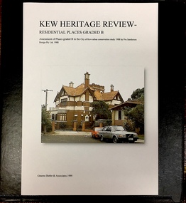
Archive (Sub-series) - Subject File, Kew Heritage Review, Residential Places Graded B, Volume 1, 1999, 1999
Graeme Butler & AssociatesProject FilesProvenance OrderBlack 4-Ring binder that includes research about, and an assessment of buildings previously graded B in the City of Kew Urban Conservation Study 1988 by Pru Sanderson Design Pty Ltd. The files were created by the heritage architect Graeme Butler and the paper files include maps, correspondence, title searches, readings, reviews of prior classifications, newspaper and journal articles, directories etc for each property assessed.graeme butler, heritage reviews - kew, 20 yarra street, 8 yarra street, 33 wills street, 25 wellington street, 11 wellington street, 118 walpole street, 84 walpole street, 83 walpole street, 63 walpole street, 52 walpole street, 51 walpole street, 14 vista avenue, 12 tara avenue, 89 studley park road, 75 studley park road, 44 studley park road, 25 studley park road, 13 studley avenue, 21 stoke avenue, 71 stevenson street, 34 stevenson street, 12 stevenson street, 36 stawell street, 11 second avenue, 3 second avenue, 2 second avenue, 34 rowland street, 21 redmond street, 11 redmond street, 16 queen street, 27 princess street, 82 molesworth street, 28 miller grove, 26 miller grove, 24 miller grove, 24 milfay avenue, 8 milfay avenue, 4 merrion grove, 25 mary street, 24 lister avenue, 2 john street, 9 hume street, 7 hume street, 24 howard street, 20 howard street, 19 howard street, 10 howard street, 2 howard street, 26 holroyd street, 12 holroyd street, 73 high street, 69 high street, 35 high street, 6 high street, 53 harp road, 6 gellibrand street, 48 foley street, 9 eglinton street, 25-27 edgecombe street, 21-23 edgecombe street, 5-7 edgecombe street, 23 dunlop avenue, 167 derby street, 8 denmark street, 1 denmark street, 2 daracomb avenue, 2 danielle place, 340 cotham road, 294 cotham road, 241 cotham road, 221-229 cotham road, 208 cotham road, 193 cotham road, 180 cotham road, 171 cotham road, 167 cotham road, 161 cotham road, 135-137 cotham road, 46 clyde street, 4 cameron court, 1291 burke road, 1223 burke road, 1205 burke road, 5 bowen street, 35-37 belford road, 389 barkers road, 387 barkers road, 311 barkers road, 231 barkers road, 83-85 barkers road, 15 adeney avenue, 6 a'beckett streetgraeme butler, heritage reviews - kew, 20 yarra street, 8 yarra street, 33 wills street, 25 wellington street, 11 wellington street, 118 walpole street, 84 walpole street, 83 walpole street, 63 walpole street, 52 walpole street, 51 walpole street, 14 vista avenue, 12 tara avenue, 89 studley park road, 75 studley park road, 44 studley park road, 25 studley park road, 13 studley avenue, 21 stoke avenue, 71 stevenson street, 34 stevenson street, 12 stevenson street, 36 stawell street, 11 second avenue, 3 second avenue, 2 second avenue, 34 rowland street, 21 redmond street, 11 redmond street, 16 queen street, 27 princess street, 82 molesworth street, 28 miller grove, 26 miller grove, 24 miller grove, 24 milfay avenue, 8 milfay avenue, 4 merrion grove, 25 mary street, 24 lister avenue, 2 john street, 9 hume street, 7 hume street, 24 howard street, 20 howard street, 19 howard street, 10 howard street, 2 howard street, 26 holroyd street, 12 holroyd street, 73 high street, 69 high street, 35 high street, 6 high street, 53 harp road, 6 gellibrand street, 48 foley street, 9 eglinton street, 25-27 edgecombe street, 21-23 edgecombe street, 5-7 edgecombe street, 23 dunlop avenue, 167 derby street, 8 denmark street, 1 denmark street, 2 daracomb avenue, 2 danielle place, 340 cotham road, 294 cotham road, 241 cotham road, 221-229 cotham road, 208 cotham road, 193 cotham road, 180 cotham road, 171 cotham road, 167 cotham road, 161 cotham road, 135-137 cotham road, 46 clyde street, 4 cameron court, 1291 burke road, 1223 burke road, 1205 burke road, 5 bowen street, 35-37 belford road, 389 barkers road, 387 barkers road, 311 barkers road, 231 barkers road, 83-85 barkers road, 15 adeney avenue, 6 a'beckett street -
 Kew Historical Society Inc
Archive (series) - Subject File, Authors (Kew), 1958
Various PartiesReference, Research, InformationKHS OrderReference file containing Sundry information about authors (poets, novelists, playwrights, historians, politicians, journalists) who were born, educated, lived or died in Kew, initially compiled by Society member Elizabeth Mackie who had previously researched the artists of Kew. Since the file was created, various items including correspondence and newspaper articles/cuttings have been added. Some information relates to organisations rather than individuals, such as that Kew was once the headquarters of the Fellowship of Australian Writers (1/317 Barkers Road). Within the file there is correspondence and curriculum vitae supplied by: Allan Aldous, Lillian Wood, Michele Nayman (1981), Yetta Rothberg (1981), Judith Rodriguez (1981), Rev Dr Arthur de Quetteville Robin (1982). The File also includes a photocopy of a letter supplied by Prof A D Hope (1981) relating to his memories of Kew. Authors mentioned in the file include: Allan Aldous, F G A Barnard, James Bonwick, Martin Boyd, Vincent Buckley, Sir Macfarlane Burnet, Anne M Carson, John Clements, Rita Erlich, Barbara Giles, Alison Goding, A D Hope, Wendy Jacobs, Lally Katz, Jill Manton, Philip Martin, James McAuley, Pauline McKinnon, Philip Mendez, Marrion Miller, Michele Nayman, Brenda Niall, Mark O’Connor, Nettie Palmer, Vance Palmer, Rev Dr Arthur de Quetteville Robin, Judith Rodriguez, Myra Roper, Dorothy Rogers, Yetta Rothberg, Frederick Sinnett, John Stanley, Peter Steele, W D Vaughan, Gwen Walker, J M Walsh, Lillian Wood.authors - kew (vic)authors - kew (vic) -
Kew Historical Society Inc
Archive (Sub-series) - Subject File, Conservation Study (Kew) 1978, 1978
Various partiesReference, Research, InformationSecondary Values (KHS Imposed Order)Subject file containing a copy of the City of Kew’s Urban Renewal Proposal (13pp), dated June 1978. The proposal to the Urban Renewal Authority relates to those houses in Denmark Street, High Street South and Barkers Road, then known as ‘The Triangle’ (historically known as O’Shaughnessy’s Paddock. The report refers to the Kew Triangle Association.urban renewal -- kew (vic.), conservation studies -- kew (vic.), kew triangle associationurban renewal -- kew (vic.), conservation studies -- kew (vic.), kew triangle association -
 Kew Historical Society Inc
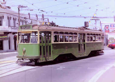
Photograph - Y1 Class 611 in Barkers Road and High Street South, 1990
This colour photograph, with 15 others are enlargements gifted to the Society by Mel Lawrence in 2016. They were taken at a commemorative event from the Kew Tram Depot. Laminated colour enlargement of Y1 Class 611, on the corner of Barkers Road and High Street South, during a re-enactment from the Kew Depot in 1990.Annotation reverse: "Kew Depot 1990. Y1 Class 611, turning out of Barkers Road into High Street South"kew tram depot, trams -- melbourne, y1 class trams -
 Kew Historical Society Inc
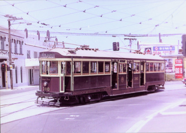
Photograph - W Class 380 turning out of Barkers Road into High Street South, 1990
This colour photograph, with 15 others are enlargements gifted to the Society by Mel Lawrence in 2016. They were taken at a commemorative event from the Kew Tram Depot. Laminated colour enlargement of W Class tram No.380 turning out of Barkers Road into High Street South, during a re-enactment in 1990.Annotation reverse: "Kew Depot 1990. W Class 380 turning out of Barkers Road into High Street South"kew tram depot, trams -- melbourne, a class trams -
Kew Historical Society Inc
Journal, Kewriosity : October 1992
Asthma - a matter of 'life and breath' / p1. Chief Executive's Column [1992/93 Rates and charges] / Malcolm Hutchinson p2&3. Mayor's Comment / Cr Roger Streeton p3. Diary Dates [October - November 1992] / p4. A quiet crisis [mental health] / p5. Be wiser with medicines poster competition / p5. In Brief [Kew East Primary School musical; Chinese Academy opens in Kew; Kew Bowling Club; Kew Youth Band; Kew Croquet Club; Instrumental Group] / p6. Best of luck Lisa! [Gaffney] / p7. Hello to a new face [Katina Brighton] / p7. New carry bags for the Library / p7. Council News [Barkers Road cutting; Hard rubbish collection] / p8.Kewriosity was a local newsletter combining Kew Council and community news. It was published between November 1983 and June 1994, replacing an earlier Kewriosity [broad] Sheet (1979-84). In producing Kewriosity, Council aimed to provide a range of interesting and informative articles covering its deliberations and decision making, together with items of general interest and importance to the Kew community and information not generally available through daily media outlets.non-fictionAsthma - a matter of 'life and breath' / p1. Chief Executive's Column [1992/93 Rates and charges] / Malcolm Hutchinson p2&3. Mayor's Comment / Cr Roger Streeton p3. Diary Dates [October - November 1992] / p4. A quiet crisis [mental health] / p5. Be wiser with medicines poster competition / p5. In Brief [Kew East Primary School musical; Chinese Academy opens in Kew; Kew Bowling Club; Kew Youth Band; Kew Croquet Club; Instrumental Group] / p6. Best of luck Lisa! [Gaffney] / p7. Hello to a new face [Katina Brighton] / p7. New carry bags for the Library / p7. Council News [Barkers Road cutting; Hard rubbish collection] / p8.publications -- city of kew (vic.), kewriosity, council newsletters, community newsletters -
Kew Historical Society Inc
Journal, Kewriosity : May 1991
Flying doctors descend on Kew [Crawford Productions] / p1. Computerised court opens [Penalty Enforcement by Registration of an Infringement (PERIN)] / p1. Stop or give-way? [Council assessment of intersections] / p1. Council seeks kinder review / p1. Diary dates for May / p2. Your marching champions [Kew Band, Kew Youth Band] / p2. Word of mouth [Pre-school story time at Kew Library 1996- ] / p2. Something airey [exhibition at Kew Gallery] / p2. Something pre-loved [Glass Street Kindergarten trash 'n treasure sale] / p2. Commentary [Willsmere redevelopment] / Cr Daryl Oldaker p3. Traffic headaches for Barkers Road [drain upgrade] / p3. Trees versus powerlines / p4. Loyal service [Tom Gascoyne] / p4. Traffic Management update [Area 7, Area 10] / p4. Cleaner shopping centres / p4. Hard rubbish collection / p4. Willsmere Drain / p4. Survey of dual occupancy / p4. Health [Department] stall / p5. Women's health workshops / p5. Baby Change Room [Walpole Street] / p5. Nursing Mothers' meetings / p5. Status quo for family day care [industrial award ruling] / p5. Immunisation - Important / p5. Daytime garden / p6. Library Friends' [book] sale / p6. [East Kew Bowling Club] Indoor bowls / p6. Chrysanthemums, M'am [Kew Garden Club] / p6. Handy Veterans Service [Kew sub-branch of the RSL] / p6. Crime wave [Neighbourhood Watch Areas G64, G97] / p6. All this for sixpence [Balwyn Cinema history] / p6. Positive [survey] feedback [to Kewriosity] / p6. Arthritis meeting / p6. Something fishy [Ian Napier at Raya Gallery] / p7. [Kew] Community House courses / p7. Coming events at Trinity [Grammar] / p7. Carmelite Monastery restoration / p7. Council Chamber or Council void? [descriptive comparison of Walpole Street Town Hall with the Chamber at the Municipal [Civic] Offices] / p8. Evangelist meeting [St Hilary's] / p8. Youth empowerment [Youth Resource Centre] / Kate Lang p8. Missions meeting [Kew Baptist Church Hall] / p8.Kewriosity was a local newsletter combining Kew Council and community news. It was published between November 1983 and June 1994, replacing an earlier Kewriosity [broad] Sheet (1979-84). In producing Kewriosity, Council aimed to provide a range of interesting and informative articles covering its deliberations and decision making, together with items of general interest and importance to the Kew community and information not generally available through daily media outlets.non-fictionFlying doctors descend on Kew [Crawford Productions] / p1. Computerised court opens [Penalty Enforcement by Registration of an Infringement (PERIN)] / p1. Stop or give-way? [Council assessment of intersections] / p1. Council seeks kinder review / p1. Diary dates for May / p2. Your marching champions [Kew Band, Kew Youth Band] / p2. Word of mouth [Pre-school story time at Kew Library 1996- ] / p2. Something airey [exhibition at Kew Gallery] / p2. Something pre-loved [Glass Street Kindergarten trash 'n treasure sale] / p2. Commentary [Willsmere redevelopment] / Cr Daryl Oldaker p3. Traffic headaches for Barkers Road [drain upgrade] / p3. Trees versus powerlines / p4. Loyal service [Tom Gascoyne] / p4. Traffic Management update [Area 7, Area 10] / p4. Cleaner shopping centres / p4. Hard rubbish collection / p4. Willsmere Drain / p4. Survey of dual occupancy / p4. Health [Department] stall / p5. Women's health workshops / p5. Baby Change Room [Walpole Street] / p5. Nursing Mothers' meetings / p5. Status quo for family day care [industrial award ruling] / p5. Immunisation - Important / p5. Daytime garden / p6. Library Friends' [book] sale / p6. [East Kew Bowling Club] Indoor bowls / p6. Chrysanthemums, M'am [Kew Garden Club] / p6. Handy Veterans Service [Kew sub-branch of the RSL] / p6. Crime wave [Neighbourhood Watch Areas G64, G97] / p6. All this for sixpence [Balwyn Cinema history] / p6. Positive [survey] feedback [to Kewriosity] / p6. Arthritis meeting / p6. Something fishy [Ian Napier at Raya Gallery] / p7. [Kew] Community House courses / p7. Coming events at Trinity [Grammar] / p7. Carmelite Monastery restoration / p7. Council Chamber or Council void? [descriptive comparison of Walpole Street Town Hall with the Chamber at the Municipal [Civic] Offices] / p8. Evangelist meeting [St Hilary's] / p8. Youth empowerment [Youth Resource Centre] / Kate Lang p8. Missions meeting [Kew Baptist Church Hall] / p8. publications -- city of kew (vic.), kewriosity, council newsletters, community newsletters -
Kew Historical Society Inc
Journal, Kewriosity : July 1990
Hayes Paddock - or bussed [Threes and Fours Kindergarten - Holy Trinity Church] / p1. Rooms with a view [Willsmere] / p1. Barkers Road silenced [drains] / p1. Dates for July / p2. Local theatre company presents [Spectrum Theatre Company] / p2. Tour of Williamstown / p2. Holy Trinity Evensong / p2. Commentary / Cr Michael Montalto / p3. Council to form Willsmere Liaison Committee / p3. Participation = rich rewards [role of councillors] / p3. Healthy faces [Council health surveyor profiles] / p4. Committee examines recycling / p4. Tuesday freedom for mum [Occasional Care Centre] / p5. Burning issues / p5. Plans to computerise [Kew] Library / p5. Compost bins for sale / p5. Traffic management update / p6. Your say on [Kew] Junction / p6. Cyclists and pedestrians - together or apart? [Outer Circle Reserve] / p7. Council rejects Met safety zone plan / p6. Packing tonnes of cars in / p7. She's won Tatts / p7. Attempt to counter elm diseases / p8. Rotaract donation / p8. [Kew] Band players win / p8. Asthma Foundation stretches legs / p8. Music initiative / p8. Our Glad's play [Viola Musical Theatre] / p8. Adult literacy award / p8.Kewriosity was a local newsletter combining Kew Council and community news. It was published between November 1983 and June 1994, replacing an earlier Kewriosity [broad] Sheet (1979-84). In producing Kewriosity, Council aimed to provide a range of interesting and informative articles covering its deliberations and decision making, together with items of general interest and importance to the Kew community and information not generally available through daily media outlets.non-fictionHayes Paddock - or bussed [Threes and Fours Kindergarten - Holy Trinity Church] / p1. Rooms with a view [Willsmere] / p1. Barkers Road silenced [drains] / p1. Dates for July / p2. Local theatre company presents [Spectrum Theatre Company] / p2. Tour of Williamstown / p2. Holy Trinity Evensong / p2. Commentary / Cr Michael Montalto / p3. Council to form Willsmere Liaison Committee / p3. Participation = rich rewards [role of councillors] / p3. Healthy faces [Council health surveyor profiles] / p4. Committee examines recycling / p4. Tuesday freedom for mum [Occasional Care Centre] / p5. Burning issues / p5. Plans to computerise [Kew] Library / p5. Compost bins for sale / p5. Traffic management update / p6. Your say on [Kew] Junction / p6. Cyclists and pedestrians - together or apart? [Outer Circle Reserve] / p7. Council rejects Met safety zone plan / p6. Packing tonnes of cars in / p7. She's won Tatts / p7. Attempt to counter elm diseases / p8. Rotaract donation / p8. [Kew] Band players win / p8. Asthma Foundation stretches legs / p8. Music initiative / p8. Our Glad's play [Viola Musical Theatre] / p8. Adult literacy award / p8. publications -- city of kew (vic.), kewriosity, council newsletters, community newsletters -
Kew Historical Society Inc
Journal, Kew Historical Society, Newsletter No.101, December 2012
Reaching out to the community [President's Report, 2012 AGM] / David Benwell p1-2. Society Activities - History Week; A visit to Kew Primary School; Past meetings / p3. From the archives / Dorothy Benyei p4. Lost and wanted [Mooroolbeek; Clutha] / p4. Gallipoli and beyond: April 2015 / Alex Wilson OAM p5. The mystery of Barkers Track / Alex Wilson OAM p6. Eleanor Haidee Simeon c.1822-1910 / Robert Baker p7-8. 'Malinda' [aka 'Bella Vista', 276 Cotham Road] / Dione McIntyre p9. The baby grand [Just Theatre] / Judith Vimpani / p10. Kew Court House / p10. History and heritage online [ websites] / Robert Baker p11. 2012-13 Calendar / p12.Published quarterly since 1977, the newsletters of the Kew Historical Society contain significant research by members exploring relevant aspects of the Victorian and Australian Framework of Historical Themes. Frequently, articles on people, places and artefacts are the only source of information about an aspect of Kew, and Melbourne’s history.non-fictionReaching out to the community [President's Report, 2012 AGM] / David Benwell p1-2. Society Activities - History Week; A visit to Kew Primary School; Past meetings / p3. From the archives / Dorothy Benyei p4. Lost and wanted [Mooroolbeek; Clutha] / p4. Gallipoli and beyond: April 2015 / Alex Wilson OAM p5. The mystery of Barkers Track / Alex Wilson OAM p6. Eleanor Haidee Simeon c.1822-1910 / Robert Baker p7-8. 'Malinda' [aka 'Bella Vista', 276 Cotham Road] / Dione McIntyre p9. The baby grand [Just Theatre] / Judith Vimpani / p10. Kew Court House / p10. History and heritage online [ websites] / Robert Baker p11. 2012-13 Calendar / p12. kew historical society (vic.) -- periodicals., kew historical society (vic.) -- newsletters, kew historical society (vic.) -- journals -
 Kew Historical Society Inc
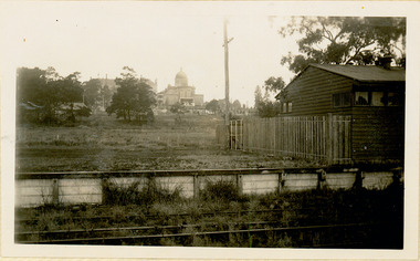
Photograph - The last train at Barker Station, 1952
The Kew railway was opened in 1887, and diverged from the main (Box Hill–Lilydale) line about half-way between Hawthorn and Glenferrie. From the point of divergence the line was slightly less than one mile long, and it had only one intermediate station — Barker. There were four road over-bridges and two level crossings, including one over the busy Barkers Road. The line supported a passenger and goods service, and was electrified in December 1922, at the same time as the main line to Box Hill. There were a number of peak hour services which ran from Flinders Street station (Melbourne) to Kew, but in 1938 all but one of these were diverted to the Ashburton line, where traffic was growing. This had an adverse effect on Kew traffic, as passengers from Kew needed to cross over a footbridge at Hawthorn to change trains, and the main line trains were usually already crowded by the time they reached Hawthorn. At about the same time the off-peak trains were replaced by road buses. In 1952 all passenger trains were withdrawn, but the road bus service continued for many years. Goods trains were finally withdrawn in 1957, and the railway was dismantled in 1958-59. (Source: Frank Stamford, 'The Hawthorn - Kew Railway')Small black and white snapshot of the last passenger train at Barker Railway Station in 1952. The photograph, one of 12, is part of a larger album of newspaper clippings, timetables, tickets and photos relating to the Kew Railway Line, taken and compiled by Lachlan Richardson, while a resident of Kew. The album dates from the 1950s. The album is part of a larger subject file on the Kew Line, compiled over time by members of the Kew Historical Society."Last train at Barker Station / 1 August 1952"kew railway line, transport -- railways -- kew (vic.), barker railway station, kew branch line -
 Kew Historical Society Inc
Photograph - Barker Station, August 1952
The Kew railway was opened in 1887, and diverged from the main (Box Hill–Lilydale) line about half-way between Hawthorn and Glenferrie. From the point of divergence the line was slightly less than one mile long, and it had only one intermediate station — Barker. There were four road over-bridges and two level crossings, including one over the busy Barkers Road. The line supported a passenger and goods service, and was electrified in December 1922, at the same time as the main line to Box Hill. There were a number of peak hour services which ran from Flinders Street station (Melbourne) to Kew, but in 1938 all but one of these were diverted to the Ashburton line, where traffic was growing. This had an adverse effect on Kew traffic, as passengers from Kew needed to cross over a footbridge at Hawthorn to change trains, and the main line trains were usually already crowded by the time they reached Hawthorn. At about the same time the off-peak trains were replaced by road buses. In 1952 all passenger trains were withdrawn, but the road bus service continued for many years. Goods trains were finally withdrawn in 1957, and the railway was dismantled in 1958-59. (Source: Frank Stamford, 'The Hawthorn - Kew Railway')Small black and white snapshot of the last passenger train at Barker Railway Station in 1952. The photograph, one of 12, is part of a larger album of newspaper clippings, timetables, tickets and photos relating to the Kew Railway Line, taken and compiled by Lachlan Richardson, while a resident of Kew. The album dates from the 1950s. The album is part of a larger subject file on the Kew Line, compiled over time by members of the Kew Historical Society."Barker Station / August 1952"kew railway line, transport -- railways -- kew (vic.), barker railway station, kew branch line -
 Kew Historical Society Inc
Photograph - Kew Railway Station: Denmark Street entrance, 1952
The Kew railway was opened in 1887, and diverged from the main (Box Hill–Lilydale) line about half-way between Hawthorn and Glenferrie. From the point of divergence the line was slightly less than one mile long, and it had only one intermediate station — Barker. There were four road over-bridges and two level crossings, including one over the busy Barkers Road. The line supported a passenger and goods service, and was electrified in December 1922, at the same time as the main line to Box Hill. There were a number of peak hour services which ran from Flinders Street station (Melbourne) to Kew, but in 1938 all but one of these were diverted to the Ashburton line, where traffic was growing. This had an adverse effect on Kew traffic, as passengers from Kew needed to cross over a footbridge at Hawthorn to change trains, and the main line trains were usually already crowded by the time they reached Hawthorn. At about the same time the off-peak trains were replaced by road buses. In 1952 all passenger trains were withdrawn, but the road bus service continued for many years. Goods trains were finally withdrawn in 1957, and the railway was dismantled in 1958-59. (Source: Frank Stamford, 'The Hawthorn - Kew Railway')Small black and white snapshot of the entrance to Kew Station from Denmark Street in 1952. The photograph, one of 12, is part of a larger album of newspaper clippings, timetables, tickets and photos relating to the Kew Railway Line, taken and compiled by Lachlan Richardson, while a resident of Kew. The album dates from the 1950s. The album is part of a larger subject file on the Kew Line, compiled over time by members of the Kew Historical Society.kew railway line, transport -- railways -- kew (vic.), kew branch line, kew railway station -
 Kew Historical Society Inc
Photograph - Kew Station 22/4/51, F3
The Kew railway was opened in 1887, and diverged from the main (Box Hill–Lilydale) line about half-way between Hawthorn and Glenferrie. From the point of divergence the line was slightly less than one mile long, and it had only one intermediate station — Barker. There were four road over-bridges and two level crossings, including one over the busy Barkers Road. The line supported a passenger and goods service, and was electrified in December 1922, at the same time as the main line to Box Hill. There were a number of peak hour services which ran from Flinders Street station (Melbourne) to Kew, but in 1938 all but one of these were diverted to the Ashburton line, where traffic was growing. This had an adverse effect on Kew traffic, as passengers from Kew needed to cross over a footbridge at Hawthorn to change trains, and the main line trains were usually already crowded by the time they reached Hawthorn. At about the same time the off-peak trains were replaced by road buses. In 1952 all passenger trains were withdrawn, but the road bus service continued for many years. Goods trains were finally withdrawn in 1957, and the railway was dismantled in 1958-59. (Source: Frank Stamford, 'The Hawthorn - Kew Railway')Small black and white snapshot of Kew Railway Station, looking south to Barker Station. The photograph, one of 12, is part of a larger album of newspaper clippings, timetables, tickets and photos relating to the Kew Railway Line, taken and compiled by Lachlan Richardson, while a resident of Kew. The album dates from the 1950s. The album is part of a larger subject file on the Kew Line, compiled over time by members of the Kew Historical Society.kew railway line, transport -- railways -- kew (vic.), kew branch line, kew railway station -
 Kew Historical Society Inc
Photograph - Kew Branch Line : The Hawthorn Grove crossing, August 1952
The Kew railway was opened in 1887, and diverged from the main (Box Hill–Lilydale) line about half-way between Hawthorn and Glenferrie. From the point of divergence the line was slightly less than one mile long, and it had only one intermediate station — Barker. There were four road over-bridges and two level crossings, including one over the busy Barkers Road. The line supported a passenger and goods service, and was electrified in December 1922, at the same time as the main line to Box Hill. There were a number of peak hour services which ran from Flinders Street station (Melbourne) to Kew, but in 1938 all but one of these were diverted to the Ashburton line, where traffic was growing. This had an adverse effect on Kew traffic, as passengers from Kew needed to cross over a footbridge at Hawthorn to change trains, and the main line trains were usually already crowded by the time they reached Hawthorn. At about the same time the off-peak trains were replaced by road buses. In 1952 all passenger trains were withdrawn, but the road bus service continued for many years. Goods trains were finally withdrawn in 1957, and the railway was dismantled in 1958-59. (Source: Frank Stamford, 'The Hawthorn - Kew Railway')Small black and white snapshot of the Hawthorn Grove crossing, August 1952. The photograph, one of 12, is part of a larger album of newspaper clippings, timetables, tickets and photos relating to the Kew Railway Line, taken and compiled by Lachlan Richardson, while a resident of Kew. The album dates from the 1950s. The album is part of a larger subject file on the Kew Line, compiled over time by members of the Kew Historical Society.kew railway line, transport -- railways -- kew (vic.), kew branch line, hawthorn grove -- hawthorn (vic.), railway crossings -
 Kew Historical Society Inc
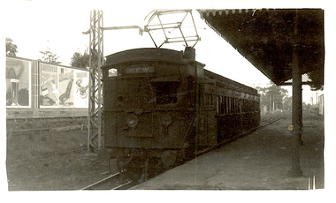
Photograph - Seven Carriage Train at Barker Station
The Kew railway was opened in 1887, and diverged from the main (Box Hill–Lilydale) line about half-way between Hawthorn and Glenferrie. From the point of divergence the line was slightly less than one mile long, and it had only one intermediate station — Barker. There were four road over-bridges and two level crossings, including one over the busy Barkers Road. The line supported a passenger and goods service, and was electrified in December 1922, at the same time as the main line to Box Hill. There were a number of peak hour services which ran from Flinders Street station (Melbourne) to Kew, but in 1938 all but one of these were diverted to the Ashburton line, where traffic was growing. This had an adverse effect on Kew traffic, as passengers from Kew needed to cross over a footbridge at Hawthorn to change trains, and the main line trains were usually already crowded by the time they reached Hawthorn. At about the same time the off-peak trains were replaced by road buses. In 1952 all passenger trains were withdrawn, but the road bus service continued for many years. Goods trains were finally withdrawn in 1957, and the railway was dismantled in 1958-59. (Source: Frank Stamford, 'The Hawthorn - Kew Railway')Small black and white snapshot of a seven carriage train approaching Barker Railway Station. The photograph, one of 12, is part of a larger album of newspaper clippings, timetables, tickets and photos relating to the Kew Railway Line, taken and compiled by Lachlan Richardson, while a resident of Kew. The album dates from the 1950s. The album is part of a larger subject file on the Kew Line, compiled over time by members of the Kew Historical Society."Seven Carriage Train at Barker Station"kew railway line, transport -- railways -- kew (vic.), barker railway station, kew branch line -
 Kew Historical Society Inc
Photograph - Farewell to 'Our Lady of Fatima'. Xavier College 22/4/51
The Kew railway was opened in 1887, and diverged from the main (Box Hill–Lilydale) line about half-way between Hawthorn and Glenferrie. From the point of divergence the line was slightly less than one mile long, and it had only one intermediate station — Barker. There were four road over-bridges and two level crossings, including one over the busy Barkers Road. The line supported a passenger and goods service, and was electrified in December 1922, at the same time as the main line to Box Hill. There were a number of peak hour services which ran from Flinders Street station (Melbourne) to Kew, but in 1938 all but one of these were diverted to the Ashburton line, where traffic was growing. This had an adverse effect on Kew traffic, as passengers from Kew needed to cross over a footbridge at Hawthorn to change trains, and the main line trains were usually already crowded by the time they reached Hawthorn. At about the same time the off-peak trains were replaced by road buses. In 1952 all passenger trains were withdrawn, but the road bus service continued for many years. Goods trains were finally withdrawn in 1957, and the railway was dismantled in 1958-59. (Source: Frank Stamford, 'The Hawthorn - Kew Railway')Small black and white snapshot of a train leaving Kew Station with the Xavier Chapel on the hill in the background, hence the ironic title provided by the photographer. The photograph, one of 12, is part of a larger album of newspaper clippings, timetables, tickets and photos relating to the Kew Railway Line, taken and compiled by Lachlan Richardson, while a resident of Kew. The album dates from the 1950s. The album is part of a larger subject file on the Kew Line, compiled over time by members of the Kew Historical Society."Farewell to 'Our Lady of Fatima'. Xavier College 22/4/51"kew railway line, transport -- railways -- kew (vic.), kew branch line, xavier college, kew railway station -
 Kew Historical Society Inc
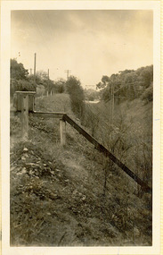
Photograph - Kew Branch Line: Looking along cutting towards Barker Station 22/4/51
The Kew railway was opened in 1887, and diverged from the main (Box Hill–Lilydale) line about half-way between Hawthorn and Glenferrie. From the point of divergence the line was slightly less than one mile long, and it had only one intermediate station — Barker. There were four road over-bridges and two level crossings, including one over the busy Barkers Road. The line supported a passenger and goods service, and was electrified in December 1922, at the same time as the main line to Box Hill. There were a number of peak hour services which ran from Flinders Street station (Melbourne) to Kew, but in 1938 all but one of these were diverted to the Ashburton line, where traffic was growing. This had an adverse effect on Kew traffic, as passengers from Kew needed to cross over a footbridge at Hawthorn to change trains, and the main line trains were usually already crowded by the time they reached Hawthorn. At about the same time the off-peak trains were replaced by road buses. In 1952 all passenger trains were withdrawn, but the road bus service continued for many years. Goods trains were finally withdrawn in 1957, and the railway was dismantled in 1958-59. (Source: Frank Stamford, 'The Hawthorn - Kew Railway')Small black and white snapshot looking along cutting towards Barker Station 22/4/51. The photograph, one of 12, is part of a larger album of newspaper clippings, timetables, tickets and photos relating to the Kew Railway Line, taken and compiled by Lachlan Richardson, while a resident of Kew. The album dates from the 1950s. The album is part of a larger subject file on the Kew Line, compiled over time by members of the Kew Historical Society."Looking along cutting towards Barker Station 22/4/51"kew railway line, transport -- railways -- kew (vic.), barker railway station, kew branch line -
 Kew Historical Society Inc
Photograph - The last train at Kew Station, August 1952
The Kew railway was opened in 1887, and diverged from the main (Box Hill–Lilydale) line about half-way between Hawthorn and Glenferrie. From the point of divergence the line was slightly less than one mile long, and it had only one intermediate station — Barker. There were four road over-bridges and two level crossings, including one over the busy Barkers Road. The line supported a passenger and goods service, and was electrified in December 1922, at the same time as the main line to Box Hill. There were a number of peak hour services which ran from Flinders Street station (Melbourne) to Kew, but in 1938 all but one of these were diverted to the Ashburton line, where traffic was growing. This had an adverse effect on Kew traffic, as passengers from Kew needed to cross over a footbridge at Hawthorn to change trains, and the main line trains were usually already crowded by the time they reached Hawthorn. At about the same time the off-peak trains were replaced by road buses. In 1952 all passenger trains were withdrawn, but the road bus service continued for many years. Goods trains were finally withdrawn in 1957, and the railway was dismantled in 1958-59. (Source: Frank Stamford, 'The Hawthorn - Kew Railway')Small black and white snapshot of the last passenger train at Kew Railway Station in 1952. The photograph, one of 12, is part of a larger album of newspaper clippings, timetables, tickets and photos relating to the Kew Railway Line, taken and compiled by Lachlan Richardson, while a resident of Kew. The album dates from the 1950s. The album is part of a larger subject file on the Kew Line, compiled over time by members of the Kew Historical Society."The last train at Kew Station, August 1952"kew railway line, transport -- railways -- kew (vic.), kew branch line, kew railway station -
 Kew Historical Society Inc
Photograph - Kew Branch Line: Weeds at Kew Station 14/51
The Kew railway was opened in 1887, and diverged from the main (Box Hill–Lilydale) line about half-way between Hawthorn and Glenferrie. From the point of divergence the line was slightly less than one mile long, and it had only one intermediate station — Barker. There were four road over-bridges and two level crossings, including one over the busy Barkers Road. The line supported a passenger and goods service, and was electrified in December 1922, at the same time as the main line to Box Hill. There were a number of peak hour services which ran from Flinders Street station (Melbourne) to Kew, but in 1938 all but one of these were diverted to the Ashburton line, where traffic was growing. This had an adverse effect on Kew traffic, as passengers from Kew needed to cross over a footbridge at Hawthorn to change trains, and the main line trains were usually already crowded by the time they reached Hawthorn. At about the same time the off-peak trains were replaced by road buses. In 1952 all passenger trains were withdrawn, but the road bus service continued for many years. Goods trains were finally withdrawn in 1957, and the railway was dismantled in 1958-59. (Source: Frank Stamford, 'The Hawthorn - Kew Railway')Small black and white snapshot of how the Kew Branch Line was allowed to run down. The photograph, one of 12, is part of a larger album of newspaper clippings, timetables, tickets and photos relating to the Kew Railway Line, taken and compiled by Lachlan Richardson, while a resident of Kew. The album dates from the 1950s. The album is part of a larger subject file on the Kew Line, compiled over time by members of the Kew Historical Society.kew railway line, transport -- railways -- kew (vic.), barker railway station, kew branch line -
 Kew Historical Society Inc
Photograph - Kew Railway Station, May 1950
The Kew railway was opened in 1887, and diverged from the main (Box Hill–Lilydale) line about half-way between Hawthorn and Glenferrie. From the point of divergence the line was slightly less than one mile long, and it had only one intermediate station — Barker. There were four road over-bridges and two level crossings, including one over the busy Barkers Road. The line supported a passenger and goods service, and was electrified in December 1922, at the same time as the main line to Box Hill. There were a number of peak hour services which ran from Flinders Street station (Melbourne) to Kew, but in 1938 all but one of these were diverted to the Ashburton line, where traffic was growing. This had an adverse effect on Kew traffic, as passengers from Kew needed to cross over a footbridge at Hawthorn to change trains, and the main line trains were usually already crowded by the time they reached Hawthorn. At about the same time the off-peak trains were replaced by road buses. In 1952 all passenger trains were withdrawn, but the road bus service continued for many years. Goods trains were finally withdrawn in 1957, and the railway was dismantled in 1958-59. (Source: Frank Stamford, 'The Hawthorn - Kew Railway')Small black and white snapshot of Kew Railway Station inMay 1950. The photograph, one of 12, is part of a larger album of newspaper clippings, timetables, tickets and photos relating to the Kew Railway Line, taken and compiled by Lachlan Richardson, while a resident of Kew. The album dates from the 1950s. The album is part of a larger subject file on the Kew Line, compiled over time by members of the Kew Historical Society."Kew Railway Station, May 1950"kew railway line, transport -- railways -- kew (vic.), kew branch line, kew railway station -
 Kew Historical Society Inc
Photograph - Kew Railway Station, 1951
The Kew railway was opened in 1887, and diverged from the main (Box Hill–Lilydale) line about half-way between Hawthorn and Glenferrie. From the point of divergence the line was slightly less than one mile long, and it had only one intermediate station — Barker. There were four road over-bridges and two level crossings, including one over the busy Barkers Road. The line supported a passenger and goods service, and was electrified in December 1922, at the same time as the main line to Box Hill. There were a number of peak hour services which ran from Flinders Street station (Melbourne) to Kew, but in 1938 all but one of these were diverted to the Ashburton line, where traffic was growing. This had an adverse effect on Kew traffic, as passengers from Kew needed to cross over a footbridge at Hawthorn to change trains, and the main line trains were usually already crowded by the time they reached Hawthorn. At about the same time the off-peak trains were replaced by road buses. In 1952 all passenger trains were withdrawn, but the road bus service continued for many years. Goods trains were finally withdrawn in 1957, and the railway was dismantled in 1958-59. (Source: Frank Stamford, 'The Hawthorn - Kew Railway')Small black and white snapshot of Kew Railway Station in 1950. The photograph, one of 12, is part of a larger album of newspaper clippings, timetables, tickets and photos relating to the Kew Railway Line, taken and compiled by Lachlan Richardson, while a resident of Kew. The album dates from the 1950s. The album is part of a larger subject file on the Kew Line, compiled over time by members of the Kew Historical Society."Kew Station / 14/51 / 22/4/51 F5"kew railway line, transport -- railways -- kew (vic.), kew branch line, kew railway station -
 Kew Historical Society Inc
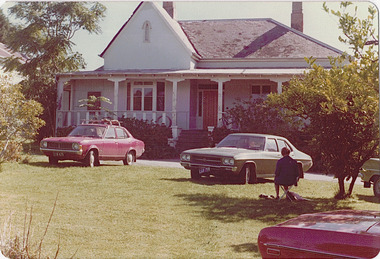
Photograph - 'Neama', Studley Park Road, 1978
Edward Augustus Atkyns was born in Wiltshire, England in 1840. His family emigrated to Australia in 1852. As a young man he was a keen cricketer and played at the first cricket ground in the district, located between Barkers Road and Hawthorn Grove, on the site of the future Barker railway station. Atkyns was admitted to the Victorian Bar in 1861, initially working in his father’s practice. He sat as a local magistrate in both Kew and Hawthorn and acted as solicitor for several shire councils. Elected to the Hawthorn Borough Council in 1863 at the age of 23, he served in that municipality as mayor in 1866-67. By 1877, he had moved to Kew where he lived at Neama in Studley Park Road, a property later incorporated into the St Paul’s School for the Blind.Rare colour photograph of what was once a significant house in Kew.Original colour positive photograph (Kodak print) of the main house of 'Neama', colloquially known as the 'farmhouse'. Photographed by Stewart West in April 1978 (it was later demolished by the Villa Maria Society).Annotated reverse: "Front view of Neama / Farmhouse on St Paul's School for the Blind Children / Fernhurst Estate"st paul's school for the blind, neama, studley park road -- kew (vic.), historic houses -- kew (vic.), villa maria society -
 Kew Historical Society Inc
Photograph - 'Neama', Studley Park Road, 1978
Edward Augustus Atkyns was born in Wiltshire, England in 1840. His family emigrated to Australia in 1852. As a young man he was a keen cricketer and played at the first cricket ground in the district, located between Barkers Road and Hawthorn Grove, on the site of the future Barker railway station. Atkyns was admitted to the Victorian Bar in 1861, initially working in his father’s practice. He sat as a local magistrate in both Kew and Hawthorn and acted as solicitor for several shire councils. Elected to the Hawthorn Borough Council in 1863 at the age of 23, he served in that municipality as mayor in 1866-67. By 1877, he had moved to Kew where he lived at Neama in Studley Park Road, a property later incorporated into the St Paul’s School for the Blind.Rare colour photograph of what was once a significant house in Kew.Original colour positive photograph (Kodak print) of the secondary building at 'Neama', colloquially known as the 'hall'. Photographed by Stewart West in April 1978 (it was later demolished by the Villa Maria Society).Annotated reverse: "Timber hall on Fernhurst land / Transported there approx 1878."st paul's school for the blind, neama, studley park road -- kew (vic.), historic houses -- kew (vic.), villa maria society -
Kew Historical Society Inc
Archive (Series) - Rockingham, Barkers Road
... Rockingham, Barkers Road ...Various PartiesReference, Research, InformationArranged by Secondary Values (value of records to users)‘Rockingham’ was a house built along Barkers Road around the mid-1850s (exact year unknown). Now demolished, the property passed through many influential hands of Melbourne, including John Herbert Syme, once manager of the ‘Age’. The file includes: Newspaper articles on the demolition of ‘Rockingham’, and a letter directed towards the Kew Historical Society with a photograph of the property which is kept separate to the file.rockingham – kew (vic.), john herbert syme – kew (vic.)rockingham – kew (vic.), john herbert syme – kew (vic.) -
 Kew Historical Society Inc
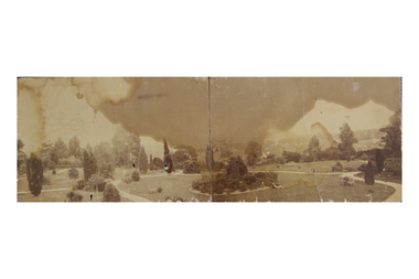
Photograph, Garden of 'Rockingham', Kew, c.1870
Built by John Bournane, Rockingham had a number of occupants before the newspaper magnate David Syme purchased it in 1902. The house in the 1860s and ‘70s was comprised of nine rooms, and was surrounded by a veranda on the front and sides. It was approached from the Kew road by the curve in front of the Hon. S.G. Henty’s mansion of ‘Findon’.In 1955, the Syme family sold Rockingham to the Red Cross Society to be used as a convalescent home for returned servicemen. The house was sold, demolished, and the land subdivided in 1966.An early panoramic photograph of an early Kew mansion (now demolished), dating from the 1870s.A rare, panoramic photograph (c.1870) of the garden of ‘Rockingham’, during the occupation of the house by W. Gardiner Esq. Rockingham was located beside and above the Barkers Road cutting. The view of the garden in the photograph is of the terraces leading down to the Yarra River. At the time the photograph was taken, the property covered an area of “…nine acres of beautifully laid-out grounds, interspersed with numerous terraces leading down the sloping bank of the river”.rockingham, david syme, kew -
 Kew Historical Society Inc
Plan - Subdivision Plan, Corsewall Estate, 1938
The Kew Historical Society collection includes almost 100 subdivision plans pertaining to suburbs of the City of Melbourne. Most of these are of Kew, Kew East or Studley Park, although a smaller number are plans of Camberwell, Deepdene, Balwyn and Hawthorn. It is believed that the majority of the plans were gifted to the Society by persons connected with the real estate firm - J. R. Mathers and McMillan, 136 Cotham Road, Kew. The Plans in the collection are rarely in pristine form, being working plans on which the agent would write notes and record lots sold and the prices of these. The subdivision plans are historically significant examples of the growth of urban Melbourne from the beginning of the 20th Century up until the 1980s. A number of the plans are double-sided and often include a photograph on the reverse. A number of the latter are by noted photographers such as J.E. Barnes.The Corsewall Estate was a subdivision, bordering on Barkers Road and Auburn Road, which created Corsewall Close. This relatively late subdivision included 29 allotments. The subdivision plan includes the dimensions of each lot as well as the width of the existing and projected roads and turning circles. The Corsewall Close Precinct is now listed on the Victorian Heritage Database (HO147) and is noted for its ‘consistent flat-type development over the entire street, which has been cleverly designed to make multi-unit dwellings appear as single buildings’.subdivision plans - hawthorn, corsewall estate -- hawthorn (vic.) -
 Kew Historical Society Inc
Postcard, Victoria Street Bridge, Collingwood, 1905-1913
Victoria Bridge is a riveted and welded steel Warren truss bridge over the Yarra River completed in 1884 to a design by Fraser & Chase following a controversial design competition held in 1880. Funds for the bridge's construction were provided by the councils of Collingwood, Hawthorn, Kew and Richmond. The contract was awarded to Mr P. Platt. Charles Rowand was officially appointed Supervising Engineer in 1883. The winning design was based on the theoretical work of William Charles Kernot (1845-1909) who campaigned for economy in public works design and the application of scientific principles in engineering. ... The bridge was widened in 1890 by the addition of a third line of truss on new piers on the up stream side to carry horse trams. Work commenced in 1914 to convert the horse tramway to an electric tramway by the Prahran & Malvern Tramways Trust, part of the Trust's extension of its tramway into the eastern suburbs between 1913-18. In 1915 the bridge was further strengthened to accommodate the extra weight of electric trams and widened by the addition of two six feet cantilever footpaths. During this period the Prahran & Malvern Tramways Trust erected two ornamental gantries over the roadway to support overhead wires for the electric tramway. Further widening and reconditioning of the bridge took place in 1933, including the addition of four new welded trusses, two intermediate and two on the outside. The latter were supported on new cantilevered truss cross beams attached to the top of the piers. (Source: Heritage Victoria)Early and rare postcard of the Victoria Street Bridge linking Victoria Street and Barkers Road.Polychrome postcard of the Victoria Street Bridge which links Richmond and Abbotsford with Kew and Hawthorn.View from Harrison Cres embankment / former Xavier College boatshed on site of tree in foreground. / Chimney left corner - Wool Scoring Mils in Victoria St. / On horizon - Studley Villa, Studley House circa 1880s, Studley Hall / Chinese gardens to be seen behind three set of columns / M.J. Slatterypostcards -- yarra river, postcards -- bridges. -- greater melbourne (vic.), victoria street bridge