Showing 1018 items
matching cement
-
 Marysville & District Historical Society
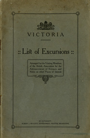
Booklet (Item) - Information booklet, Albert J. Mullett, Victoria-List of Excursions, 1914
A booklet of a list of excursions that was arranged for the visiting members of the British Association for Advancement of Science which included Marysville. These excursions were conducted in August 1914. They included geological excursions as well as excursions to local attractions to observe the flora and fauna found in and around the various destinations. The excursions were to Bacchus Marsh, Marysville, Warburton and Cement Creek, the Macedon District, Emerald, Ballarat and the local district, Bendigo and surrounds, Wilson's Promontory, and the Central Research Farm at Werribee. There is also a chapter on other places of interest in Victoria which includes Mount Buffalo, the Gippsland Lakes, the Buchan Caves, Daylesford, Lorne and Sorrento.A booklet of a list of excursions that was arranged for the visiting members of the British Association for Advancement of Science which included Marysville.victoria, british association for the advancement of science, bacchus marsh, marysville, warburton, cement creek, macedon, emerald, ballarat, bendigo, wilson's promontory, central research farm werribee, werribee, mount buffalo, gippsland lakes, buchan caves, daylesford, lorne, sorrento -
 Port Fairy Historical Society Museum and Archives
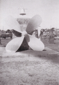
Photograph, 1930's
This Memorial was set up in memory of the nine people who drowned when the S.S.Casino sank in Apollo Bay in 1932.The cement plinth carries a bronze plaque with the names of the nine people who drowned on one side, the propeller, the wreck bell used to alert the lifeboat crew that there was an incident in the bay and for many years a large barometer that was consulted by the local fishermen before setting out to sea. A memorial Service is held each year on July the 10th at 11 am the time that the sinking took place. The Casino was about to celebrate her 50th year of plying the southwest trade route. Black and white photograph of Propeller from SS Casino as memorial memorial, s.s.casino, propeller, barometer, moyne river, sea -
 Flagstaff Hill Maritime Museum and Village
Container - Barrel, 19th century
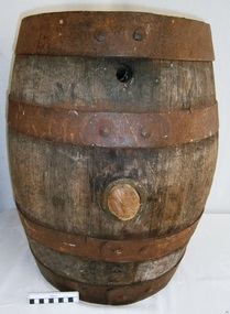
This small barrel looks well used. Unfortunately, the inscription on the barrel is indecipherable so its story is a mystery. However, the bungholes on the side are a clue that it was once used for storing liquid, likely to have been liquor. Barrels have been used over many centuries for transporting and storing a wide range of dry and liquid goods. They are made by tradesmen called coopers, who use heat and steam to bend and shape the wood to suit the work in hand. They add metal reinforcing, handles, spouts and suchlike, to complete they process. Their produce also includes buckets, casks and tubs. Ships transported bulk liquor in their cargo, stored in wooden barrels. The barrels' round shape allowed them to be easily moved by rolling them into place. The body's shape gave the barrels added strength and the iron bands helped the wooden sheaves stay in place. The tops and bottoms allowed for easy grip. The bungholes gave access to government representatives, who would sample the contents, measure the alcohol percentage, and charge the appropriate duty or tax; the process was called Ullaging and the instrument they used was a Hydrometer. Hundreds of barrels of cement were imported into Warrnambool in the late 19th century for the construction of the Warrnambool Breakwater. Barrel-shaped concrete blocks are still visible at shipwreck sites such as on the LOCH ARD wreck, which carried cement among its cargo.This small barrel is representative of 19th century containers used for transportation and storage of liquid such as liquor. It is a historic shape that is still used in modern times.Barrel; wooden barrel, cylindrical shape with metal bands or ribs for reinforcement. The side has two bungholes; one has a bung or stopper. Inscription on top (indecipherable). (indecipherable)flagstaff hill, warrnambool, shipwrecked-coast, flagstaff-hill, flagstaff-hill-maritime-museum, maritime-museum, shipwreck-coast, flagstaff-hill-maritime-village, barrel, cask, small barrel, trade, coopering, cooper, casket, transport, storage, bunghole -
 Emerald Museum & Nobelius Heritage Park
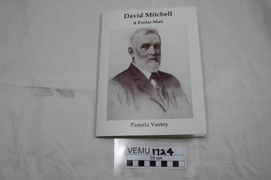
Book, David Mitchell, A Forfar Man by Pamela Vestey, 2014
David Mitchell was born near the town of Forfar, Scotland, became an apprentice to a stone mason and builder, then emigrated to Australia in 1853. In Melbourne, he set up a builder's yard in Burnley St, Richmond and later bought Cave Hill Limestone Quarries in Lilydale and manufactured the cement in Richmond. He became Shire President for Lillydale in 1883. Also he established a brickworks in Burnley St, Richmond. He was responsible for building PLC College in East Melbourne, Menzies Hotel, The Exhibition building and Scots Church. Although he was very wealthy in his own right, he is also known as the father of Dame Nellie Melba. White soft cover booklet with a large drawing of David Mitchell (1901) on the front. -
 Kew Historical Society Inc
Photograph - 'Fernhurst', 13 Fernhurst Grove, 1978
George Wharton arrived in Melbourne in 1844. An architect and surveyor, he was appointed to lay out the 'Village of Kew' by N.A. Fenwick following the land sales of 1851. A protagonist for Kew's separation from the Boroondara District Road Board, he was elected chairman when Kew achieved municipal status in December 1860. His home, 'Fernhurst', was built in 1866 on eight acres in Studley Park, with a four-storey tower and pyramidal roof. The Italianate home was a prominent Kew landmark. It was demolished in 1979 and replaced by St Paul's College in 1980.Rare colour photograph of what was once a significant mansion in Kew.Original colour positive photograph (Kodak print) of 'Fernhurst' in 1978. Photographed by Stewart West in May 1978, one year before it was demolished, the photograph gives little idea of the large landholding once surrounding the house. Originally accessed from near the corner of Princess Street and Studley Park Road, its gardens had been subdivided in the 1900s and its footprint restricted to 13 Fernhurst Grove. Like many other grand houses, by the 1970s it had been converted into apartments. From the photograph, one can see that the house had retained many of its original features such as the distinctive tower and the wide bow-fronted verandah. The slates on the roof (apart from those on the tower) had been replaced by tiles and the cement render of the exterior painted white. Annotated reverse: "View of Fernhurst Home Taken from Street / 10"fernhurst, 13 fernhurst grove -- kew (vic.), george wharton, italianate architecture, vila maria society, st paul's school for the blind -
 Kew Historical Society Inc
Photograph - 'Fernhurst', 13 Fernhurst Grove, 1978
George Wharton arrived in Melbourne in 1844. An architect and surveyor, he was appointed to lay out the 'Village of Kew' by N.A. Fenwick following the land sales of 1851. A protagonist for Kew's separation from the Boroondara District Road Board, he was elected chairman when Kew achieved municipal status in December 1860. His home, 'Fernhurst', was built in 1866 on eight acres in Studley Park, with a four-storey tower and pyramidal roof. The Italianate home was a prominent Kew landmark. It was demolished in 1979 and replaced by St Paul's College in 1980.Rare colour photograph of what was once a significant mansion in Kew.Original colour positive photograph (Kodak print) of 'Fernhurst' in 1978. Photographed by Stewart West in May 1978, one year before it was demolished, the photograph gives little idea of the large landholding once surrounding the house. Originally accessed from near the corner of Princess Street and Studley Park Road, its gardens had been subdivided in the 1900s and its footprint restricted to 13 Fernhurst Grove. Like many other grand houses, by the 1970s it had been converted into apartments. From the photograph, one can see that the house had retained many of its original features such as the distinctive tower and the wide bow-fronted verandah. The slates on the roof (apart from those on the tower) had been replaced by tiles and the cement render of the exterior painted white. Annotated reverse: "Fernhurst from higher ground level side shot / 7"fernhurst, 13 fernhurst grove -- kew (vic.), george wharton, italianate architecture, vila maria society, st paul's school for the blind -
 Kew Historical Society Inc
Photograph - 'Fernhurst', 13 Fernhurst Grove, 1978
George Wharton arrived in Melbourne in 1844. An architect and surveyor, he was appointed to lay out the 'Village of Kew' by N.A. Fenwick following the land sales of 1851. A protagonist for Kew's separation from the Boroondara District Road Board, he was elected chairman when Kew achieved municipal status in December 1860. His home, 'Fernhurst', was built in 1866 on eight acres in Studley Park, with a four-storey tower and pyramidal roof. The Italianate home was a prominent Kew landmark. It was demolished in 1979 and replaced by St Paul's College in 1980.Rare colour photograph of what was once a significant mansion in Kew.Original colour positive photograph (Kodak print) of 'Fernhurst' in 1978. Photographed by Stewart West in May 1978, one year before it was demolished, the photograph gives little idea of the large landholding once surrounding the house. Originally accessed from near the corner of Princess Street and Studley Park Road, its gardens had been subdivided in the 1900s and its footprint restricted to 13 Fernhurst Grove. Like many other grand houses, by the 1970s it had been converted into apartments. From the photograph, one can see that the house had retained many of its original features such as the distinctive tower and the wide bow-fronted verandah. The slates on the roof (apart from those on the tower) had been replaced by tiles and the cement render of the exterior painted white. Annotated reverse: "Back view of Fernhurst / 8"fernhurst, 13 fernhurst grove -- kew (vic.), george wharton, italianate architecture, vila maria society, st paul's school for the blind -
 Kew Historical Society Inc
Photograph - 'Fernhurst', 13 Fernhurst Grove, 1978
George Wharton arrived in Melbourne in 1844. An architect and surveyor, he was appointed to lay out the 'Village of Kew' by N.A. Fenwick following the land sales of 1851. A protagonist for Kew's separation from the Boroondara District Road Board, he was elected chairman when Kew achieved municipal status in December 1860. His home, 'Fernhurst', was built in 1866 on eight acres in Studley Park, with a four-storey tower and pyramidal roof. The Italianate home was a prominent Kew landmark. It was demolished in 1979 and replaced by St Paul's College in 1980.Rare colour photograph of what was once a significant mansion in Kew.Original colour positive photograph (Kodak print) of 'Fernhurst' in 1978. Photographed by Stewart West in May 1978, one year before it was demolished, the photograph gives little idea of the large landholding once surrounding the house. Originally accessed from near the corner of Princess Street and Studley Park Road, its gardens had been subdivided in the 1900s and its footprint restricted to 13 Fernhurst Grove. Like many other grand houses, by the 1970s it had been converted into apartments. From the photograph, one can see that the house had retained many of its original features such as the distinctive tower and the wide bow-fronted verandah. The slates on the roof (apart from those on the tower) had been replaced by tiles and the cement render of the exterior painted white. Annotated reverse: "Fernhurst front view taken from across Fernhurst Grove / 6"fernhurst, 13 fernhurst grove -- kew (vic.), george wharton, italianate architecture, vila maria society, st paul's school for the blind -
 Kew Historical Society Inc
Photograph - 'Fernhurst', 13 Fernhurst Grove, 1978
George Wharton arrived in Melbourne in 1844. An architect and surveyor, he was appointed to lay out the 'Village of Kew' by N.A. Fenwick following the land sales of 1851. A protagonist for Kew's separation from the Boroondara District Road Board, he was elected chairman when Kew achieved municipal status in December 1860. His home, 'Fernhurst', was built in 1866 on eight acres in Studley Park, with a four-storey tower and pyramidal roof. The Italianate home was a prominent Kew landmark. It was demolished in 1979 and replaced by St Paul's College in 1980.Rare colour photograph of what was once a significant mansion in Kew.Original colour positive photograph (Kodak print) of 'Fernhurst' in 1978. Photographed by Stewart West in May 1978, one year before it was demolished, the photograph gives little idea of the large landholding once surrounding the house. Originally accessed from near the corner of Princess Street and Studley Park Road, its gardens had been subdivided in the 1900s and its footprint restricted to 13 Fernhurst Grove. Like many other grand houses, by the 1970s it had been converted into apartments. From the photograph, one can see that the house had retained many of its original features such as the distinctive tower and the wide bow-fronted verandah. The slates on the roof (apart from those on the tower) had been replaced by tiles and the cement render of the exterior painted white. Annotated reverse: "Front view of Fernhurst showing tower to advantage / 9"fernhurst, 13 fernhurst grove -- kew (vic.), george wharton, italianate architecture, vila maria society, st paul's school for the blind -
 Kew Historical Society Inc
Photograph - 'Fernhurst', 13 Fernhurst Grove, 1978
George Wharton arrived in Melbourne in 1844. An architect and surveyor, he was appointed to lay out the 'Village of Kew' by N.A. Fenwick following the land sales of 1851. A protagonist for Kew's separation from the Boroondara District Road Board, he was elected chairman when Kew achieved municipal status in December 1860. His home, 'Fernhurst', was built in 1866 on eight acres in Studley Park, with a four-storey tower and pyramidal roof. The Italianate home was a prominent Kew landmark. It was demolished in 1979 and replaced by St Paul's College in 1980.Rare colour photograph of what was once a significant mansion in Kew.Original colour positive photograph (Kodak print) of 'Fernhurst' in 1978. Photographed by Stewart West in May 1978, one year before it was demolished, the photograph gives little idea of the large landholding once surrounding the house. Originally accessed from near the corner of Princess Street and Studley Park Road, its gardens had been subdivided in the 1900s and its footprint restricted to 13 Fernhurst Grove. Like many other grand houses, by the 1970s it had been converted into apartments. From the photograph, one can see that the house had retained many of its original features such as the distinctive tower and the wide bow-fronted verandah. The slates on the roof (apart from those on the tower) had been replaced by tiles and the cement render of the exterior painted white. Annotated reverse: "Fernhurst corner shot through trees / 12-22"fernhurst, 13 fernhurst grove -- kew (vic.), george wharton, italianate architecture, vila maria society, st paul's school for the blind -
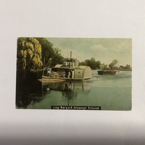 Port of Echuca
Coloured Postcard, W.T.P Post card, Original photograph probably taken late 1890's Postcard c. 1908 (postcard appears to be dated 08)
P. S. Adelaide was a logging steamer operating between Echuca and Barmah forest. It was built in 1866 by G. Linklater, Echuca. Original owner J. G. Grassie, Poon Boon Station & S. H. Officer, Murray Downs Station. In June 1891 she was purchased by Murray River Sawmills and spent most of her working life on the Barmah Forest run. In 1960 she was purchased by Echuca Apex Club and steamed to Echuca. Installed on a bed of cement in Hopwood Gardens, Echuca before being restored to be refloated as a significant addition to the Port of Echuca maritime fleet (Parsons, R. Ships of the Inland Rivers. 2005. p.46)The P.S Adelaide is extremely significant as it it the oldest known wooden hulled paddle steamer in the world. She was built in Echuca in 1866 and still operates on the Murray River today. She has worked in the Wool Industry, the Timber Industry and the Tourist Industry.Colour (hand painted?) postcard and colour negative f P. S. Adelaide towing an outrigger barge. Three men can be seen on the lower deck and one on the top deck.on the front of the postcard:". Log barge & steamer Echuca" On the bow of the steamer: "Adelaide". On reverse of postcard, in blue pen:" PORT 16.3.82 COL NEG 13x18x1." In black pen encased in a square:"396.1" In blue fountain pen. Letter addressed to "Mrs. J. Robertson 37 Roxburgh St. Ascot Vale." " Your letter to hand(?) Sat. I am much better since my trip away. Was sorry to hear Jess(?) was not well. Hope she is better again. Hoping all are well. Love to all H." Postcard stamped: "Echuca Victoria Ap 6 08" Printed in green "Post W.T.P. Card". In has a red one penny postage stamp in top right hand corner.p. s. adelaide, echuca, port of (riverboats), echuca - history, post cards, echuca, paddle steamers, timber barges -
 Eltham District Historical Society Inc
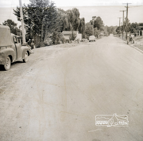
Photograph, Near 145 Mountainview Road, Briar Hill, early to mid 1960s, 1960s
In this picture we see the cement mixer on the right so possibly stone work being undertaken both sides of the street. Work is under way at the house one down from the bend where two piles of bluestone are gathered; possibly for terrace edging of the driveway and footpath. These images were from a strip of negatives, most likely taken by a Shire of Eltham employee so the works could have been part of council operations. Many streets in the shire have stonework edges for gardens abutting footpaths where the roads have been cut into the terrain. Much of this stone masonry work was undertaken for the council by C.J. Watson and Sons.Roll of medium format 120 6x6 black and white negative film, 1 stripbriar hill, c.j. watson and sons, fx holden, mountainview road, side-car, motorcycles -
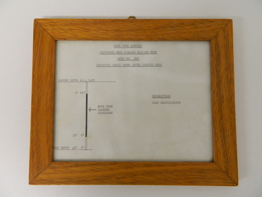 Kiewa Valley Historical Society
Sketch Rock Core Display, circa mid to late 1900's
This framed sketch details, in graphic form, where the core samples in the display cabinet were removed. The drilling was a precursor to the decision where to locate, in this case, the McKay Creek Power Station. The information gained by structural engineers from the core samples would be used also for the placements of underground tunnels entry and exit points and the overall effective size of the plant. This would have included drill and blast techniques(rock characteristics play an import part of explosion control), requirements for support structures and reinforcing cement/steel forms. The use and replenishment of diamond drill bits(the strongest available, see KVHS 0280) was dependent on the "type" of rock found. Support beams for reinforced ceilings and floors was also a necessity.The visual derails of where the rock core samples were removed is very significant in the formulation and placement of the underground Power Stations and their maze of tunnels(in and out) for a successful implementation of the Hydro Scheme. The amount of pre-planning and scientific studies required for such a large scheme must be undertaken to ensure that a "white elephant" was not the result.This framed and glass front rock core display sketch has type written information of the rock samples displayed in KVHS 0279 (A). It has a softwood stained and glossed frame with a fixed(nailed) back board and a brass fixture for mounting onto a wall.The paper and type are slighted faded (sunlight affected). The sign heading "ROCK CORE SAMPLES RECOVERED FROM DIAMOND DRILLED BORE" underneath this "BORE NO: 883" and below this "LOCATION: McKAY CREEK POWER STATION AREA" to the left a sketch incorporating the ground level point "GROUND LEVEL R.L.3493", and the core depth point "CORE DEPTH 40' 7". In between and representing( in visual form) the core location areain question.alternate energy supplies, alpine feasibility studies temperature, rainfall, sec, kiewa hydro scheme, electricity -
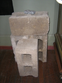 Harcourt Valley Heritage & Tourist Centre
concrete blocks, 1914
Charles Seelenmeyer conducted Concrete Utilities Limited (Harcourt Cement Pipe Factory). Operated in Harcourt circa 1914 to 1930 in premises situated opposite the ANA Hall on what is now the road reserve. Principal raw material was sand from the adjacent waterway ( Barkers Creek.) Principal output was concrete drainage tiles for use in district orchards but concrete blocks were also produced for construction of homes and commercial buildings. At a time of rapid expansion of the orchards this industry provided a vital piece of orchard infrastructure, mostly buried and not now visible but nevertheless a very important feature of the valley’s horticultural industry.. Homes built with these concrete blocks are a distinct part of Harcourt’s housing stock. Harcourt Cement Pipe Co was an example of local initiative to solve a local problem using local materials. A collection of 4 concrete building blocks -
 Bendigo Historical Society Inc.
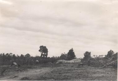
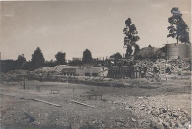
Photograph - Napoleon Reef Gold Mine Battery Site, 1936
The Napoleon (BML) gold mine (1932) was located beside McDougall Road, Golden Gully, between Martin and Hattam Street. It had a depth of 921 feet. It was one of the latest and most lavish of Bendigo's mines. Plant and equipment were electrically driven. The four-compartment shaft, extra large by goldfield's standards, measured 17 feet 6 inches by 5 feet 2 inches and was cement lined below 900 feet instead of being red gum boxed as was the usual practice. The workshop was equipped to carry out all repairs for the equally lavish BML mines on the Nell Gwynne and Carshalton reefs. (The Gold Mines of Bendigo, Book 2, Arthur Victor Palmer)Significant to mining history of Bendigo.Black and white photograph. Image shows flat, open landscape with four large eucalypt trees in centre of image. Four men working with shovels on left hand side of image, one man with wheelbarrow and dog alongside. Wooden framed structure on right hand side. Written in pencil on back of photograph: ' Battery excavations started 22/9/36' and 'excavations started'.napoleon gold mine, napoleon reef gold mine -
 Bendigo Historical Society Inc.
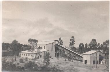
Photograph - Napoleon Mine Battery, 1936
The Napoleon (BML) gold mine (1932) was located beside McDougall Road, Golden Gully, between Martin and Hattam Street. It had a depth of 921 feet. It was one of the latest and most lavish of Bendigo's mines. Plant and equipment were electrically driven. The four-compartment shaft, extra large by goldfield's standards, measured 17 feet 6 inches by 5 feet 2 inches and was cement lined below 900 feet instead of being red gum boxed as was the usual practice. The workshop was equipped to carry out all repairs for the equally lavish BML mines on the Nell Gwynne and Carshalton reefs. (The Gold Mines of Bendigo, Book 2, Arthur Victor Palmer)Significant to mining history of Bendigo.Black and white photograph: landscape view of mine sheds. Battery shed fully completed with trestleway to another shed. Trees in background. Written in pencil on back of photograph: 'completed battery 5/12/36'napoleon gold mine, napoleon reef gold mine -
 Bendigo Historical Society Inc.
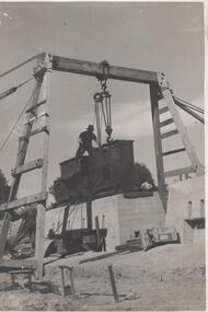
Photograph - Napoleon Reef Gold Mine Battery Site, 1936
The Napoleon (BML) gold mine (1932) was located beside McDougall Road, Golden Gully, between Martin and Hattam Street. It had a depth of 921 feet. It was one of the latest and most lavish of Bendigo's mines. Plant and equipment were electrically driven. The four-compartment shaft, extra large by goldfield's standards, measured 17 feet 6 inches by 5 feet 2 inches and was cement lined below 900 feet instead of being red gum boxed as was the usual practice. The workshop was equipped to carry out all repairs for the equally lavish BML mines on the Nell Gwynne and Carshalton reefs. (The Gold Mines of Bendigo, Book 2, Arthur Victor Palmer)Significant to mining history of Bendigo.Black and white photograph of a stamper head being lowered into position on the battery site of the Napoleon Reef Gold Mine. A wooden gantry supports the battery head as it being lowered, a man is standing on top of the stamper head. Concrete foundations are visible in immediate background. napoleon gold mine, napoleon reef gold mine -
 Bendigo Historical Society Inc.
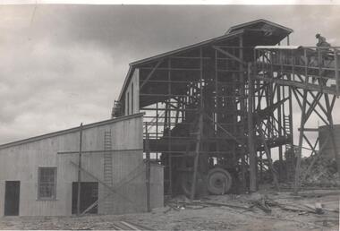
Photograph - Napoleon Mine Battery, 1936
The Napoleon (BML) gold mine (1932) was located beside McDougall Road, Golden Gully, between Martin and Hattam Street. It had a depth of 921 feet. It was one of the latest and most lavish of Bendigo's mines. Plant and equipment were electrically driven. The four-compartment shaft, extra large by goldfield's standards, measured 17 feet 6 inches by 5 feet 2 inches and was cement lined below 900 feet instead of being red gum boxed as was the usual practice. The workshop was equipped to carry out all repairs for the equally lavish BML mines on the Nell Gwynne and Carshalton reefs. (The Gold Mines of Bendigo, Book 2, Arthur Victor Palmer)Significant to mining history of Bendigo.Black and white photograph: battery shed under erectionWritten in pencil on back of photograph: 'battery erection 17/1`1/36' and 'cracker station building' napoleon gold mine, napoleon reef gold mine -
 Bendigo Historical Society Inc.
Photograph - Napoleon Mine Battery, 1936
The Napoleon (BML) gold mine (1932) was located beside McDougall Road, Golden Gully, between Martin and Hattam Street. It had a depth of 921 feet. It was one of the latest and most lavish of Bendigo's mines. Plant and equipment were electrically driven. The four-compartment shaft, extra large by goldfield's standards, measured 17 feet 6 inches by 5 feet 2 inches and was cement lined below 900 feet instead of being red gum boxed as was the usual practice. The workshop was equipped to carry out all repairs for the equally lavish BML mines on the Nell Gwynne and Carshalton reefs. (The Gold Mines of Bendigo, Book 2, Arthur Victor Palmer)Significant to mining history of Bendigo.Black and white photograph: battery under construction, concrete bottom blocks being 'boxed' up .Written in pencil on back of photograph: 'another new daring creation' and ' boxing the foundation 7/10/36'.napoleon gold mine, napoleon reef gold mine -
 City of Moorabbin Historical Society (Operating the Box Cottage Museum)
Manufactured Glass, brown bottle, 20thC
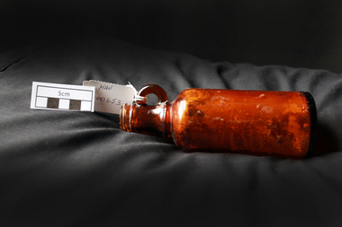
This bottle may have held medicine used by a local early settler family. A local resident discovered it when digging his garden in McKinnon 2013. James Hardie immigrated to Australia in 1888 from Linlithgow, Scotland, and created a business importing oils and animal hides. Andrew Reid, also from Linlithgow, came to join Hardie in Melbourne, and became a full partner in 1895. When Hardie retired in 1911, he sold his half of the business to Reid. James Hardie Industries Ltd first listed on the Australian Stock Exchange in 1951 and is an industrial building materials company headquartered in Ireland which specialises in fibre cement products. James Hardie manufactures and develops technologies, materials and processes for the production of building materials. For over 20 years, Hardie has also operated a research and development facility devoted solely to fibre-cement technology. The company was a key player in asbestos mining and manufacturing in Australia through most of the twentieth century. Working with products containing asbestos - including the building material known as "Fibro" - caused people to develop various pleural abnormalities such as asbestosis and malignant mesothelioma. In December 2001, the company shareholders unanimously voted to restructure and relocate the company in the Netherlands as a parent company. This was part of a strategy to separate the company from the stigma of its asbestos liabilities. February 2010, James Hardie moved its corporate domicile from The Netherlands to Ireland, In May 2012 the High Court of Australia found that seven former James Hardie non-executive directors misled the stock exchange over the asbestos victims compensation fundA brown glass bottle, with finger grip handlearound bottom " THIS BOTTLE ALWAYS REMAINS THE PROPERTY OF JAMES HARDIE PTY. LTD. SYDNEY' on base 'IS985 / 7early settlers, pioneers, market gardeners, moorabbin, bentleigh, ormond, mvkinnon, glass bottles, medine containers, medical supplies, james hadie pty ltd. hardie -
 City of Moorabbin Historical Society (Operating the Box Cottage Museum)
Manufactured Glass, brown bottle, 20th C
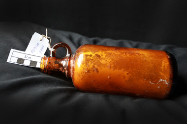
This bottle may have held medicine used by a local early settler family. A local resident discovered it when digging his garden in McKinnon 2013. James Hardie immigrated to Australia in 1888 from Linlithgow, Scotland, and created a business importing oils and animal hides. Andrew Reid, also from Linlithgow, came to join Hardie in Melbourne, and became a full partner in 1895. When Hardie retired in 1911, he sold his half of the business to Reid. James Hardie Industries Ltd first listed on the Australian Stock Exchange in 1951 and is an industrial building materials company headquartered in Ireland which specialises in fibre cement products. James Hardie manufactures and develops technologies, materials and processes for the production of building materials. For over 20 years, Hardie has also operated a research and development facility devoted solely to fibre-cement technology. The company was a key player in asbestos mining and manufacturing in Australia through most of the twentieth century. Working with products containing asbestos - including the building material known as "Fibro" - caused people to develop various pleural abnormalities such as asbestosis and malignant mesothelioma. In December 2001, the company shareholders unanimously voted to restructure and relocate the company in the Netherlands as a parent company. This was part of a strategy to separate the company from the stigma of its asbestos liabilities. February 2010, James Hardie moved its corporate domicile from The Netherlands to Ireland, In May 2012 the High Court of Australia found that seven former James Hardie non-executive directors misled the stock exchange over the asbestos victims compensation fund' A brown glass bottle with finger ring hold at neck that may have been used by a local home owner to hold medicine c1900around base ' THIS BOTTLE ALWAYS REMAINS THE PROPERTY OF JAMES HARDIE PTY LTD SYDNEY ' on base ' IS 994 ' pioneers, market gardeners, moorabbin, bentleigh, ormond, mvkinnon, glass bottles, medine containers, medical supplies, james hadie pty ltd. hardie, early settlers -
 Federation University Historical Collection
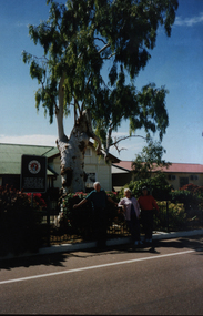
Photograph - Colour, Barcaldine Tree of Knowledge, 1998, 07/1998
Its twisted old trunk is gnarled, its disembowelled carcass plump with cement and now, like many outback legends, its cadaverously pale and very dead. It has stood, an unmolested leafy sentinel, over Barcaldine’s Railway Station depot since the 1880s. It was a living Australian Labor Party memorial and heritage-listed. The double centurion, Oak Street’s most senior resident, was respectfully nursed into its dotage by Barcaldine’s faithful. Countless thousands of travellers photographed it, patted it and peered up at its bushy green tops with dutiful reverence. ... And then, by an act of craven foul play, it was murdered. Allegedly. Cold, hard forensic science pronounced death by poisoning. Sometime around May Day 2007 they reckon. (Australian Travellor, November 25, 2007.)Photograph of Philip and Elizabeth under the Barcaldine Tree. It was in the shade of this tree the Australian workers rallied and the Australian Labor Party was formed after the ramifications of the great shearers strike in 1891.barcaldine tree, australian labor party, chatham-holmes family collection -
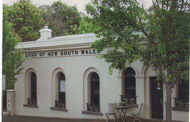 Linton and District Historical Society Inc
Photograph, Traquair House, Sussex Street, Linton, 2014
The original bank and residence were built in 1862, and the building was extended in 1873-74. The three windows on the left of the photograph are in the original building, and the windows and door on the right of the photograph are in the extension. The brick building was cement-rendered at an unknown later date. In 1904 the Bank of New South Wales built a new banking chamber & residence on the west side of Sussex Street next to the Post Office, after which the earlier building became a private residence. It was lived in for many years by members of the Lewers family (Samuel Lewers had been first manager of the Bank of NSW in Linton) and was purchased in the early 1960s by Stella Surman (née Todd). More recently it has been used as an antique shop and tea rooms, and it is currently a private residence. This photograph was taken in 2014 by Gary Hunt.One of three colour photographs printed on a single sheet of photographic paper. The photograph shows Linton's first Bank of New South Wales building, now called Traquair House.traquair house, 90 sussex street linton, buildings, houses, bank of new south wales -
 National Wool Museum
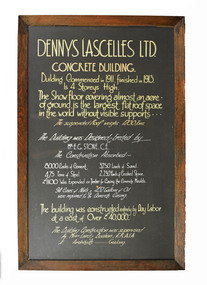
Sign - Display Board, Dennys Lascelles Ltd Concrete Building
Display panel giving details re: the construction of the Dennys Lascelles concrete building (the Bow Truss building) adjacent to the Dennys Lascelles wool offices and store (now NWM) in 1911-13. The building was designed as a show floor for wool bales, thus the lack of columns and roof supports was significant in providing free space. It was designed by Mr E.G. Stone and construction was supervised by Laird and Buchan. It was demolished in the 1990s. This display board / text panel may have been created for use in the concrete building.Display board from 1913 giving details re: the construction of the Dennys Lascelles concrete building (the Bow Truss building), adjacent to their wool store and offices.DENNYS LASCELLES LTD. / CONCRETE BUILDING. / Building Commenced in 1911. Finished in 1913. / Is 4 Storeys High. / The Show Floor covering almost an acre / of ground, is the largest flat roof space / in the world without visible supports ... / The suspended Roof weighs 1200 Tons. / The Building was Designed & Erected by / MR. E.G. STONE, C.E. / The Construction Absorbed:- / 8000 Casks of Cement. 3250 Loads of Sand. / 475 Tons of Steel. 2250 Yards of Crushed Stone. / 1100 Was Expended on Timber for Casing the Concrete Moulds. / 94 Cases of Nails & 432 Gallons of Oil / were required for the Concrete Casing. / The building was constructed entirely of Day Labor / at a cost of Over 40,000. / The Building Construction was supervised / by Messrs Laird & Buchan, F.R.A.I.A. / Architects - Geelong.wool sales, wool bales, dennys, lascelles limited, stone, mr e. g. laird and buchan, dennys lascelles concrete building, bow truss building, geelong -
 Federation University Historical Collection
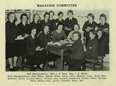
Photograph - Image - black and white, Joan Hood and students of the Ballarat Girls' Technical School, 1959, 1959
After marrying Ron Kirner, Joan Hood was known as Joan Kirner. She became the first female Premier of Victoria. “When I went out teaching, I went to Ballarat Girls Tech, where I met [husband] Ron who was at Ballarat Boys Tech. They were seen as tough schools, and I saw the disadvantage faced by these girls who were at the lowest of the low of the education rung – and yet there were some fantastic girls there who needed equal opportunity. So I think it was teaching that cemented in my mind that people don’t get an even go – and in particular girls. It didn’t take me too long to realise blokes were largely empowered. And it was teaching that cemented how equity and empowerment for women could be achieved through education.” Sarah Capper: You graduated from Melbourne University in 1958, and as mentioned, began work as a teacher in Ballarat. You married Ron in 1960 and received one of those government letters asking you to resign - JK: Yes, I think it burnt a hole in my pocket when I brought it home! We were both teachers, and I said to Ron, “Well, you got married – where’s your letter?!” That really clarified that the world wasn’t quite even, even in this profession that I’d always wanted and loved. I didn’t get superannuation – I think I got something like 100 pounds as pay in lieu of permanent service. And that wasn’t just me – that was a whole generation. Fancy that – that’s what it said – “pay in lieu of permanent service”. So that made me livid. If I hadn’t been a feminist before then, I certainly was by then. I realised the distribution of power was different for women and men. http://sheilas.org.au/2014/02/a-bonza-joan-kirner/, accessed 06/06/2015 Teacher Joan Hood (later Joan Kirner) is surrounded by a number of students from the Ballarat Girl's Technical School, all members of the Magazine Committee.joan hood, joan kirner, ballarat girls' technical school, university women, equal opportunity -
 Phillip Island and District Historical Society Inc.
Photograph Album, Kodak, Phillip Island Cemetery, c 1990
The Album was compiled by Nancy McHaffie late 1990's, with the assistance of Edith Jeffery's, with her book "Garden of Memories" and extensive knowledge of Phillip Island. The Cemetery lies back from the road and is surrounded by Manna Gums, rare Peppermint Gums, Blackwoods and other native trees. In all 25 acres of land were set aside as Crown Land in the land settlement of 1868. There are 6.2 acres of wetlands near the cemetery entrance.466-38: Rev Alexander Robb, DD. Rev Robb had been a missionary in Old Calabar and Jamaica and was the first minister of the Cowes Presbyterian Church from 1890-1901. Services were also held in the Public Hall at Rhyll. A daughter, Kathleen, like her parents, is buried in the cemetery. Kathleen was married to Harry West. 466-39: James Hill. Jimmy, as he was fondly called, came to Phillip Island in 1920 and purchased the Hotel, known as Woods Family Hotel (later the Phillip Island Hotel in Walpole Street). A milestone occurred whilst in his capable hands he installed an electric light plant, (32 volts), the first on the Island. He also made hundreds of cement bricks with which he built his own home. He died in 1937 aged 68. His only child Dorothy Edhouse aged 98, is also buried with her father.phillip island cemetery, james hill, rev alexander robb, nancy mchaffie, edith jeffery -
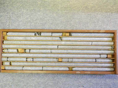 Kiewa Valley Historical Society
Core Rock Samples
The core samples in the display cabinet were obtained from the various sites at which drilling into the rock surface was carried out (under the control of design and structural engineers of the SEC Kiewa Hydro Scheme - late 1940's). This function was a precursor to the decision where to locate, in this case, the McKay Creek Power Station. The information gained by structural engineers from the core samples would be used also for the placements of underground tunnels entry and exit points and the overall effective size of the generator plant. This would have included drill and blast techniques (rock characteristics play an import part of explosion control), requirements for support structures and reinforcing cement/steel forms. The use and replenishment of diamond drill bits(the strongest available, see KVHS 0280) was dependent on the "type" of rock found (harder rock required greater numbers of drill bits). Support beams for reinforced ceilings and floors was also a necessity.These rock core samples are very significant in the formulation and placement of the underground Power Stations and their maze of tunnels (in and out) for a successful implementation of the Hydro Scheme. The amount of pre-planning and engineering studies required for such a large scheme must be undertaken to ensure that a "white elephant" was not the result.There are nine columns of rock cores, each 30mm in diameter, set in a wooden display rack. A clear plastic (slide out) protective panel is installed to the front section. Within each column are block details of the depth from which that section was brought from. See KVHS for the appropriate sketch details.Depth levels (retrieved from) are shown for each section on wooden Blocks: 1st Block: "7'10" (seven feet, ten inches), 2nd Block:"9'4" (nine feet, four inches), 3rd Block: "19'3" (nineteen feet, three inches), 4th Block: "24'2" (twenty four feet, two inches), 5th Block: "25'7"( twenty five feet, seven inches) and last block: "30' (thirty feet)"alternate energy supplies, alpine feasibility studies temperature, rainfall, sec, kiewa hydro scheme, electricity -
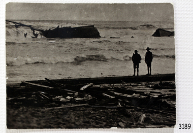
 Flagstaff Hill Maritime Museum and Village
Photograph, circa 1888
This photograph was taken close to the time of the wreck of the "Edinburgh Castle". The “Edinburgh Castle”, three-masted iron barque, was built in Glasgow, Scotland, in 1863 by J.G. Lawrie. She was 53.7 meters long and weighed 627 tons. She was owned by shipping company T Skinner and Co and registered at Liverpool, England. She sailed from 1863 to 1885 along the trade route between Scotland, China, and Singapore. In 1887 the Master, Captain J.B. Darling, sailed the “Edinburgh Castle” for its new owners Gifford & Nicholson from London to Warrnambool. Her cargo was 4,900 casks of cement for the construction of the new Warrnambool Breakwater. Over the three month journey, the ship met with rough weather and even a hurricane. On January 15th 1888 the “Edinburgh Castle” approached Lady Bay where a welcoming crowd gathered. The Port’s relief Harbour Master, Pilot Carless took over to complete the docking. As he tried to guide her, the Lighthouse Keeper signalled that the ship was too close to shore. The pilot continued on his course, causing her to ‘miss stays’ (make an incorrect tack). The crew dropped anchors and tried to lighten the load by throwing some of the casks of cement overboard but this was to no avail, and she drifted sideways in calm waters, lodging in the sand. A distress signal was sent to the coastal steamer “Julia Percy”, which spent several hours trying to pull the stranded ship away, but it would not budge. Those involved hoped to re-float the ship but efforts to save the vessel were useless. The captain and some crew stayed on board. When the weather became rough the rocket crew brought its lifesaving gear to the shore, ready to launch a line to the ship. The three men on board sent those onshore a message in a bottle to assure the on-lookers that they were quite comfortable to stay aboard. After a night of bad weather, the crew were glad to accept the rocket crew’s help and were in turn safely hauled to shore in a breeches buoy. The ship broke up quickly. Very little of the cargo could be saved. A week later all that could be seen of her was the bow and some of the stern. The beach was littered with wreckage, including cement cask fragments, for weeks. Ironically, on the morning after the ship ran aground, the very same “Edinburgh Castle” was offered for sale at an auction in Melbourne, billed as “a sound ship with all the fittings and in the best order.” The sale was completed before they heard the news that the ship was totally wrecked! Over the decades the shifting sands concealed the wreck of “Edinburgh Castle”. However, in October 1985 two local divers, Peter Ronald and Colin Goodall discovered her near the Hopkins River mouth. Peter said in his book ‘Exploring Shipwrecks of Western Victoria’, “In the midst of this sand-cloud I could clearly see row after row of neatly stacked barrels”. He remarked, “I am privileged to have had at least a glimpse of one of Warrnambool's most significant wrecks.” Some 15 – 17 ships are believed to have sunk in Lady Bay, but only two have been discovered on the seafloor; the “Edinburgh Castle” and the “La Bella”. Both wrecks are popular diving sites and are preserved as significant historical marine and marine archaeological sites. The sailing ship “Edinburgh Castle” is of local and state and national significance. It is one of the only two shipwrecks discovered in Lady Bay, Warrnambool, out of the 15-17 shipwrecks in the bay. The “Edinburgh Castle” is significant for being one of the largest vessels lost in the bay. The significance of the wreck of the “Edinburgh Castle” was recognised by being listed on the Victorian Heritage Database VHR S209. She was declared an Historic Shipwreck on 17th January 1989 under the Commonwealth Historic Shipwrecks Act (1976). The “Edinburgh Castle” wreck is also significant for the connection of its cargo with the building of the Warrnambool Breakwater, also listed on the Victorian Heritage Database VHR H2024. The “Edinburgh Castle” is included as one of the shipwrecks in Heritage Victoria’s Historic Shipwreck Trail on Victoria’s West Coast. Black and white photograph of the iron barque 'Edinburgh Castle' on breaking waves, land in the background. The ship was stranded and wrecked in Lady Bay, Warrnambool, on January 15th 1888. Figures are standing on deck. The masts are free from sails.flagstaff hill, warrnambool, shipwrecked-coast, flagstaff-hill, flagstaff-hill-maritime-museum, maritime-museum, shipwreck-coast, flagstaff-hill-maritime-village, great ocean road, edinburgh castle barque 1863, edinburgh castle shipwreck 1888, shipwreck 15-05-1888, glasgow ship, jg lawrie, t skinner and co, liverpool ship register, captain j.b. darling, gifford & nicholson, cement casks, cement barrels, warrnambool breakwater construction, breaches buoy, rocket crew, rocket launcher, lifesaving equipment, warrnambool harbour, lady bay warrnambool, ship pilot carless, lady bay shipwreck, peter ronald, colin goodall, lady bay diving site, marine archaeology, victorian heritage register, vhr s209 -
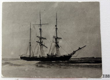
 Flagstaff Hill Maritime Museum and Village
Photograph - Photograph of Edinburgh Castle' stranded and wrecked at Lady Bay, circa 1888
This photograph was taken close to the time of the wreck of the "Edinburgh Castle". The “Edinburgh Castle”, three-masted iron barque, was built in Glasgow, Scotland, in 1863 by J.G. Lawrie. She was 53.7 meters long and weighed 627 tons. She was owned by shipping company T Skinner and Co and registered at Liverpool, England. She sailed from 1863 to 1885 along the trade route between Scotland, China, and Singapore. In 1887 the Master, Captain J.B. Darling, sailed the “Edinburgh Castle” for its new owners Gifford & Nicholson from London to Warrnambool. Her cargo was 4,900 casks of cement for the construction of the new Warrnambool Breakwater. Over the three month journey, the ship met with rough weather and even a hurricane. On January 15th 1888 the “Edinburgh Castle” approached Lady Bay where a welcoming crowd gathered. The Port’s relief Harbour Master, Pilot Carless took over to complete the docking. As he tried to guide her, the Lighthouse Keeper signalled that the ship was too close to shore. The pilot continued on his course, causing her to ‘miss stays’ (make an incorrect tack). The crew dropped anchors and tried to lighten the load by throwing some of the casks of cement overboard but this was to no avail, and she drifted sideways in calm waters, lodging in the sand. A distress signal was sent to the coastal steamer “Julia Percy”, which spent several hours trying to pull the stranded ship away, but it would not budge. Those involved hoped to re-float the ship but efforts to save the vessel were useless. The captain and some crew stayed on board. When the weather became rough the rocket crew brought its lifesaving gear to the shore, ready to launch a line to the ship. The three men on board sent those onshore a message in a bottle to assure the on-lookers that they were quite comfortable to stay aboard. After a night of bad weather, the crew were glad to accept the rocket crew’s help and were in turn safely hauled to shore in a breeches buoy. The ship broke up quickly. Very little of the cargo could be saved. A week later all that could be seen of her was the bow and some of the stern. The beach was littered with wreckage, including cement cask fragments, for weeks. Ironically, on the morning after the ship ran aground, the very same “Edinburgh Castle” was offered for sale at an auction in Melbourne, billed as “a sound ship with all the fittings and in the best order.” The sale was completed before they heard the news that the ship was totally wrecked! Over the decades the shifting sands concealed the wreck of “Edinburgh Castle”. However, in October 1985 two local divers, Peter Ronald and Colin Goodall discovered her near the Hopkins River mouth. Peter said in his book ‘Exploring Shipwrecks of Western Victoria’, “In the midst of this sand-cloud I could clearly see row after row of neatly stacked barrels”. He remarked, “I am privileged to have had at least a glimpse of one of Warrnambool's most significant wrecks.” Some 15 – 17 ships are believed to have sunk in Lady Bay, but only two have been discovered on the seafloor; the “Edinburgh Castle” and the “La Bella”. Both wrecks are popular diving sites and are preserved as significant historical marine and marine archaeological sites. The sailing ship “Edinburgh Castle” is of local and state and national significance. It is one of the only two shipwrecks discovered in Lady Bay, Warrnambool, out of the 15-17 shipwrecks in the bay. The “Edinburgh Castle” is significant for being one of the largest vessels lost in the bay. The significance of the wreck of the “Edinburgh Castle” was recognised by being listed on the Victorian Heritage Database VHR S209. She was declared an Historic Shipwreck on 17th January 1989 under the Commonwealth Historic Shipwrecks Act (1976). The “Edinburgh Castle” wreck is also significant for the connection of its cargo with the building of the Warrnambool Breakwater, also listed on the Victorian Heritage Database VHR H2024. The “Edinburgh Castle” is included as one of the shipwrecks in Heritage Victoria’s Historic Shipwreck Trail on Victoria’s West Coast. Black and white photograph of the iron barque 'Edinburgh Castle' stranded and wrecked at Lady Bay, Warrnambool, on January 15th 1888. The photograph shows wreckage along the shore and two standing figures looking on.flagstaff hill, warrnambool, shipwrecked-coast, flagstaff-hill, flagstaff-hill-maritime-museum, maritime-museum, shipwreck-coast, flagstaff-hill-maritime-village, great ocean road, edinburgh castle barque 1863, edinburgh castle shipwreck 1888, shipwreck 15-05-1888, glasgow ship, jg lawrie, t skinner and co, liverpool ship register, captain j.b. darling, gifford & nicholson, cement casks, cement barrels, warrnambool breakwater construction, breaches buoy, rocket crew, rocket launcher, lifesaving equipment, warrnambool harbour, lady bay warrnambool, ship pilot carless, lady bay shipwreck, peter ronald, colin goodall, lady bay diving site, marine archaeology, victorian heritage register, vhr s209 -
 Wodonga & District Historical Society Inc
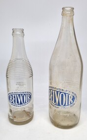
Functional object - Cordial / Soft drink Bottles - Belvoir, c1950 - 1966
Belvoir drinks were marketed by Stephens Bros. They established their business in Wodonga c1938, having taken over the aerated water and drinks business previously operated by Messrs. E. Bartel and E. Clark. Bartel and Clark had purchased S. Mason Cordial Company from Samuel Mason Jr. in 1920. Samuel Mason Sr. began a bakery and aerated water company c1857. Stephens Brothers was operated by Lindsay, Donald and William Stephens. In 1947 they manufactured their own cement bricks to build a new factory in High Street, Wodonga. Over time they operated under various names including the Wodonga Cordial Company and Belvoir Wodonga Cordial Company. In 1938 their output of aerated waters was 100 dozen bottles a day but by 1948 that had doubled. In 1949 they also established a wood yard at their High Street premises to provide additional income during the slower winter months. In 1966 the company was purchased by the Tarax Ale Brewing Co. with Lindsay Stephens staying on as Company Manager.These artefacts has local significance as they are representative of a well-known Wodonga manufacturing business.2 different sized bottles for Belvoir soft drink. Both bottles feature the blue brand on one side and information related to manufacture and contents in white print on the opposite side. The larger bottle holds 26 fluid ounces and the smaller one holds 13 fluid ounces.On front: An oval shaped name "BELVOIR" surrounded by leaf design with white text "The seal of quality" above the oval and "A Flavour for every taste" beneath the name. On opposite side in white text: "MANUFACTURED BY/ WODONGA CORDIAL CO./ WODONGA/ PRESERVATIVE ADDED / ARTIFICIALLY COLOURED/ NET CONTENTS 19 FL OZ / PHONE WODONGA -39.wodonga manufacturing, stephens bros wodonga, wodonga cordial company, belvoir drinks wodonga