Showing 5313 items
matching flood-marker-orbost
-
 Kew Historical Society Inc
Postcard, R McGeehan, The Effect of Storm. Train Passing Through Flood Waters, South Yarra, 25-1-07, 1907
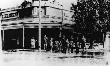
SHARP DOWNPOUR. ONE INCH IN 45 MINUTES. SOUTHERN SUBURBS DELUGED. TRAIN STOPPED AT SOUTH YARRA. One of the sudden downpours of rain which occasionally fall in Melbourne occurred yesterday afternoon, when nearly an inch of rain fell in the course of three quarters of an hour, and caused a flood for an hour or two in certain localities. During the early part of the day, the sky had been clouded over, but there was nothing to indicate a storm of such intensity as that which followed. At about half-past 1 o'clock residents of South Yarra, South Melbourne, Prahran, and St. Kilda noticed a few drops of rain. Still, it appeared unlikely that there would be anything exceptional, until with startling suddenness at about 10 minutes to 1 o'clock, one of the heaviest downpours within the memory of residents burst upon those suburbs. A strange feature of the storm was that it was practically confined to an area of about three miles square. The city was but little affected, though at a spot as close as the Observatory 86 points of rain were recorded in three-quarters of an hour. Thunder and lightning accompanied the downpour, which was cyclonic in character, the rain driving heavily from all points of the compass as the cyclone passed. It was in South Yarra and Prahran that the rain fell heaviest. Within a few minutes after it commenced, the low-lying portions of Toorak-road and practically the whole length of Chapel-street were under water. The depression at the intersection of Toorak-road and Darling-street speedily filled to the dimensions of a small lake. Several shops were inundated, while the water from the higher levels rushed down like a mountain torrent, and in several in-stances swept through the rear of houses and shops, carrying furniture in a floating mass against the further walls. In one case a footbridge was carried bodily away and dashed to pieces. Darling-street itself Great Davis-street, and other low-lying and flat thoroughfares in the vicinity became flooded from kerb to kerb, while on the other side of the railway-bridge the valley between Kensington-road and River-street became filled for some minutes to a depth of several feet. Meanwhile the waters from South Yarra hill, seeking a lower level, found it in the railway cutting, and the excavations from South Yarra station to Prahran on the one line, and to the Chapel-street bridge on the other, were converted into a couple of canals. At the platforms at South Yarra the water was two feet deep on the permanent way, and towards Hawksburn, at the sudden depression under Chapel-street bridge, it was at one time deep enough to cover a tall man's head. Into this swirling mass of water the 1:50 p.m. train from Oakleigh plunged on its way to Melbourne. The impact caused a mighty fountain of water to rise to a height of about 20 feet above the level of Chapel-street and send clouds of spray in all directions. Under the belief that a terrible explosion had occurred residents braved the rain and rushed to the spot, only to find that the train had been brought to a stand-still in the middle of what seemed to be a river. The water was so high that it had entered the fire-box from below, extinguishing the fires and cutting off the steam supply. In the meantime the officials at the South Yarra station had been preparing for emergencies. Inspectors were on duty at intervals along the line, and the moment the alarm was given an extra engine was backed carefully down and continued on to connect with the stranded train without losing its own power. There was a delay of about ten minutes in the service for an hour or two, but by 5 o'clock all the trains were running on time again, and the water had run off all but the spot beneath the Chapel-street bridge. Here the water remained about four feet deep until nightfall, and throughout the afternoon several hundreds of people including biograph operators and photographers, were gathered around watching each train pass through. Even with the water two feet lower, this was a work attended with considerable difficulty. Each train had to absolutely force its way through the weight of water, almost enveloped by the spray thrown up, and it was only just able to negotiate the "ford" by using every ounce of steam. ... The Argus, 26 January 1907, p19.The item forms part of the Laurie Bennett collection of thirty-six postcards and photographs of Kew and early Melbourne, donated to the Kew Historical Society in 1980. The postcards in the Bennett collection, like other images in the Society's holdings date from the 1890s to the present and comprehensively indicate points-of-view or scenes considered historically, aesthetically or socially significant in the period in which they were produced.Postcard depicting a flood at South Yarra Station in 1907. The title and photographer's name are identified on the front of the postcard. Donated by L. Bennett, 1980flood - south yarra, trains - melbourne, postcards, r mcgeehan - prahran -
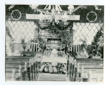 Orbost & District Historical Society
black and white photograph, C1900
The first Orbost Presbyterian Church was opened on January 9 1898. It was built by Mr R. P. Cameron for three pounds. The Harvest Festival display was always put together by the church ladies. The Festival was a family friendly festival celebrating the end of summer.This item is reminiscent of the late 19th - mid 20th centuries when church-going was more common.A black / white photograph of inside the Orbost Presbyterian Church decorated with rural produce and flowers for the "Harvest Festival". It is on a white buff card with a blue photographer's stamp in the bottom left hand corner.on front - stamp -" Herbert Sherwood" on back - "M. Gilbert, Orbost" - "Mrs J. Sterling, 6 Marine Parade , Elwood"church-presbyterian-orbost harvest-festival -
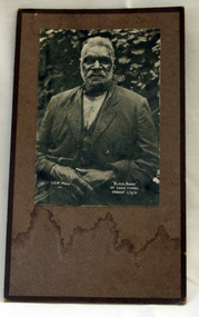 Orbost & District Historical Society
black and white photograph, "Black Andy of lake Tyers ORBOST 1/3/21", 1. 2.1921
In 1861 the Lake Tyers Mission Station was established by the Church of England missionary Reverend John Bulmer, to house some of the Gunaikurnai survivors of the conflict. The peninsula, which has a lake on each side, was known to its traditional owners as Bung Yarnda.A black and white photograph of an older, bearded Aboriginal man. He is sitting outdoors in front of a leafy bush. He is wearing a suit.Black Andy of Lake Tyers ORBOST 1/3/21 L.G.W. photo 741lake-tyers photograph -
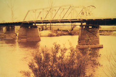 Orbost & District Historical Society
photograph, first half of 20th century prior to 1976
Purchased from Orbost Op shop several years ago. Original owner unknown. This bridge over the Snowy River was opened on July 4 1922. It was constructed in 1922 alongside the previous suspension bridge. Its building was a combined effort of the Victorian Railways and the Country Roads Board at a cost of 35,000 pounds. It was replaced in 1976 by the present bridge after several major floods.This bridge was replaced in 1976 after several major floods.A wooden framed photograph of the second Snowy River bridge at Orbost.photograph snowy-river-bridge -
 Eltham District Historical Society Inc
Photograph, George W. Bell, Flood Eltham early 1950's, 1950c
Black and white photograph of flood remains Eltham early 1950s.floods, eltham, diamond creek, george w bell collection -
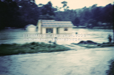 Eltham District Historical Society Inc
Photograph, 1957 flood, Railway Parade, Eltham, 1957
Colour photograph of flooded house Railway Parade Eltham 1957floods, diamond creek, eltham, railway parade -
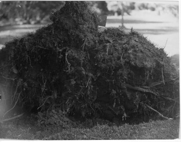 University of Melbourne, Burnley Campus Archives
Photograph - Black and white print, Orchard After Flood, 1934
Orchard after flood: shows close up of uprooted tree.orchard, yarra river, floods, 1934, fruit trees -
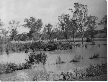
 University of Melbourne, Burnley Campus Archives
Photograph - Black and white print, Orchard in Flood, 1934
Black and white photograph. Orchard in flood, shows uprooted trees.orchard, yarra river, floods, 1934 -
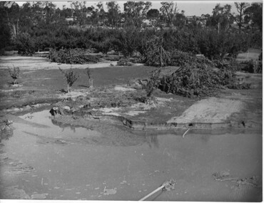
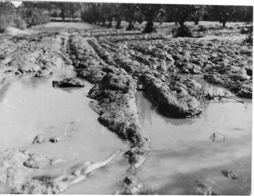
 University of Melbourne, Burnley Campus Archives
Photograph - Black and white print, Orchard in Flood, 1934
Black and white photograph. Orchard in flood: small shed in the centre.orchard, yarra river, floods, 1934 -
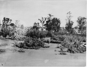 University of Melbourne, Burnley Campus Archives
Photograph - Black and white print, Orchard in Flood, 1934
Black and white photograph. Orchard in flood: shows uprooted trees.orchard, yarra river, floods, 1934, fruit trees -
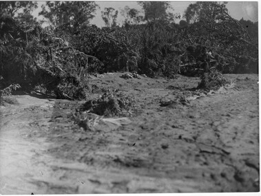
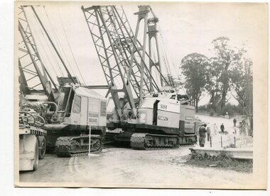 Orbost & District Historical Society
black and white photographs, 1974 - 1976
Construction of the roadway embankment between the bridges across the Snowy River flood plains at Orbost commenced in January 1974 and was completed in November 1976. Pearsons were the bridge contractors for the construction of the Princes Freeway and bridges across the river flood plains at Orbost. Heavy rains and floods held up progress.These photographs are of the construction of a major structure in Orbost. The opening of this Snowy River Bridge was an important development in the accessibility to the township of Orbost.Four black / white photographs of construction sites. 3241.1 is of three cranes and other machinery with six persons. 3241.2 is of workmen working on flooded site. 3241.3 is a photograph of the early stages of construction of a bridge looking towards the township. 3241.4 shows the construction of a roadway between the bridges.construction-snowy-river-bridge bridge-orbost -
 Lakes Entrance Historical Society
Book, LERHS, Railway Bairnsdale to Orbost, VTF Project, 2015
Information on the construction of the railway from Bairnsdale to Orbost, the stony creek, trestle bridge also plans for the very fast train from Melbourne to Sydney Lakes Entrance Victoriatransport, bridges -
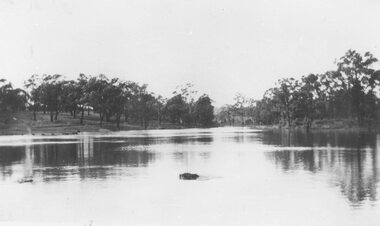 Ringwood and District Historical Society
Photograph, Ringwood Lake in flood - 1950
Typed below photograph, "Ringwood Lake in flood - 1950" -
 Eltham District Historical Society Inc
Photograph, George W. Bell, Flood Eltham early 1950's, 1950c
Black and white photograph of Diamond Creek in flood at Eltham early 1950sfloods, diamond creek, eltham, george w bell collection -
 Eltham District Historical Society Inc
Photograph, Diamond Creek in flood 1924, 1924
Colour photograph of original showing Diamond Creek in flood at Eltham 1924floods, diamond creek, eltham -
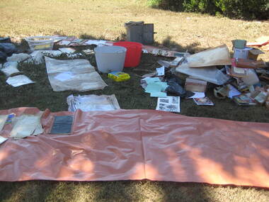 Ballarat Heritage Services
Photograph - Colour, Flood recovery, Carisbrook, 40 degree heat
Colour photographs of paperbased items being 'recovered' after the Carisbrook floods.carisbrook, flood, flood recovery -
 University of Melbourne, Burnley Campus Archives
Photograph - Black and white print, Orchard After Flood, 1934
Black and white photograph. Orchard after flood: shows uprooted trees.orchard, yarra river, floods, 1934, fruit trees -
Lakes Entrance Historical Society
Book, Orbost Historical Society, Curlip Journal, 2005
A Journal presenting history of the Orbost district produced from information gathered during a historical bus trip taken by thirty local residents to Bete Bolong Newmerella Corringle and Lochend Orbost Victoria -
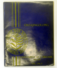 Orbost & District Historical Society
magazines, Croajingolong Document of a Decade, 1970
This is a special issue of the annual Orbost High School magazine. It revisits the decade 1960-1970. The name Croajingolong derives from the Australian Aboriginal Krauatungalung words galung, meaning "belonging to" and kraua, meaning "east". 2218.1 belonged to Mary Gilbert, a former teacher at the school.This magazine is a useful reference tool.Two copies of a magazine with a dark blue cover. It is titled Croajingolong Document of a Decade. On the front cover the print 1960-1970 Vol.2 No. 3 is in yellow/gold and the Orbost High School crest is on the left hand side in yellow. 2218.2 has autographs inside the covers. 2218.1 has the Orbost Historical Society stamp on the inside back cover.croajingolong orbost-high-school -
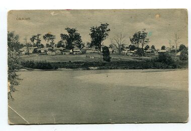 Orbost & District Historical Society
black and white photograph, Campbell. D.S, late 19th century ?
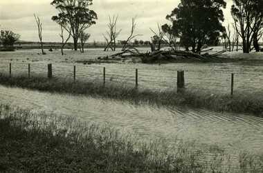
This is a photograph of the settlement of Orbost on the banks of the Snowy River,. In the foreground in the paddock there is a water trough (Bills?) and the B Drain can be seen on the far left. D.S. Campbell had a stationery store in Nicholson Street Orbost and published several black and white postcards of Orbost.This is a pictorial record o The township of Orbost in the late 19th century.A black / white photograph / postcard. There is a river in the foreground with houses and shops in the background behind a cleared paddock.on front - Orbostorbost-19th-century snowy-river -
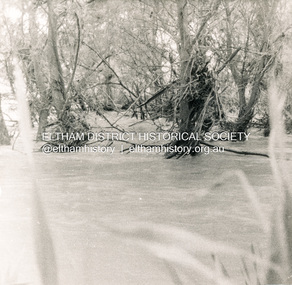
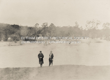
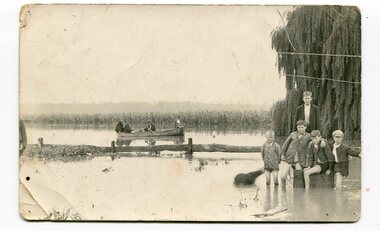 Orbost & District Historical Society
black and white photograph, 1934
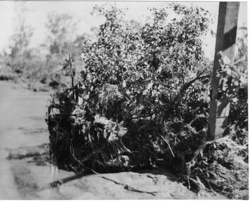
This photograph was taken during the flood of 1934 in Orbost. The people in the photograph are related to Billie and Ilma Nixon and Charlie Johnston. Damage estimated at £500,000 was caused by the 1934 floods in the Orbost district. This 1934 flood was devastating, destroying a section of the 1922 Orbost bridge, wrecking fences, bridges and roads, dumping silt and debris on the rich river flats and drowning cattle.This item is a pictorial record of a significant event in Orbost's history. It is associated with local families.A black / white photograph / postcard of floodwaters. On the right is a young man with four young boys sitting on a log. In the bckground is a rowing boat with one man rowing and three others sitting on the edges . A field of maize / corn is in the background and a large willow tree on the right.on back - "M. C. Rice Orbost 19 /1/20 M Gilbert. Mostly Billy Nixons & Charlie Johnstons 1934" [Note alteration: W C Rice rather than M C Rice].floods-orbost-1934 nixon-william johnston-charles -
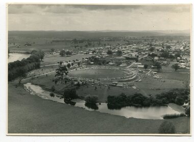 Orbost & District Historical Society
black and white photographs, March 10 1961
These photographs are pictorial record of Orbost in 1961.They enable us o observe the objects in their spatial context and in detail. They are useful for reference.Four black / white aerial photographs. there are spare copies of each. 3276.1 is an aerial photograph of the Orbost Show with Lochiel Park in the foreground. 3276.2 is an aerial photograph taken over a township. 3276.3 shows the Orbost High School on the left. 3276,4 shows the high school in the foreground.on the back of each is "March 10th 1961 Aerial of Orbost"photographs-aerial-orbost-1961 orbost-1961 lochiel-park -
 Eltham District Historical Society Inc
Photograph, Diamond Creek in flood 1924, 1924
Colour reproduction copy of an original sepia photograph of Diamond Creek in flood 1924diamond creek, floods -
 Stawell Historical Society Inc
Photograph, Flood on Concongella Creek, Great Western, early 1900's
Digital Photo taken from glass slide by Geoff McMillan, Cooper Street Stawell and reproduced as a photo - printed at Stawell Historical Society 2019Black & White Photo of flood on the Concongella Creek at Best's vineyard, Great Western. -
Whitehorse Historical Society Inc.
Article, Flood plan, 1993
$100,000 will be spent by Melbourne Water to solve flooding problems in the Fulton Road area.$100,000 will be spent by Melbourne Water to solve flooding problems in the Fulton Road area.$100,000 will be spent by Melbourne Water to solve flooding problems in the Fulton Road area.melbourne water, fulton road, blackburn south, drainage -
 Charlton Golden Grains Museum Inc
Photograph, Charlton Tribune, B/W photograph of 1971 flood, Nov 1971
B/W photograph of 1971 flood. Paddocks & roadside along Calder Highwayflood, charlton, calder highway -
 Charlton Golden Grains Museum Inc
Photograph, 1923 Flood - Telegraph Hotel, Armstrong Street Charlton, c. 1923
1923 Flood, Telegraph Hotel, Armstrong Street, Charlton, Victoria1923 flood - Telegraph Hotel, Armstrong Street Charlton. Obituary: Charlton 100 years ago 18-02-1922 - 24/02/1922. Mr Francis Gilbert Livingstone passed away at Castlemaine on 14th ins. He was a very well known & highly respected old resident of Charlton & Narrewillock. Until October last he held the license of the Telegraph Hotel and was a familiar figure in his wheel chair under the shade trees at land at Narrewillock, where he farmed until failing health compelled him to give up the strenuous work of those early pioneering days, and in 1892 he took the license of the Telegraph Hotel which he retained until recently. He was 61 years of age.flood, telegragh hotel, charlton, livingstone -
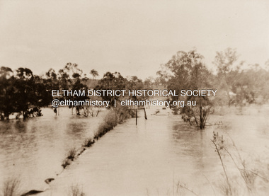
 Orbost & District Historical Society
black and white photographs, 1950s
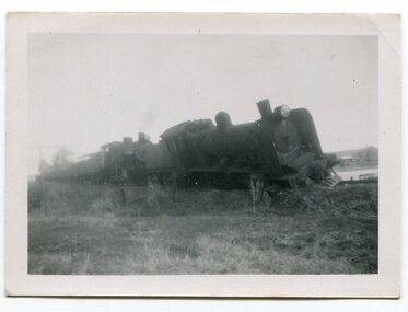
Dudley Charles Seymour Courtney , with a fellow worker, was trapped on the Orbost Raailwaay Station roof until rescued by an army duck. These photographs were his. He worked on the railway in Orbost from 1942 - 1952 approximately. During the 1952 flood nearly half of Orbost rail way station is washed away. The stationmaster and four members of his staff were rescued by police using army ducks.This is a pictorial record of a significant event in the history of Orbost.Nine small black / white photographs of a derailed train at a railway station. Derailed trucks and floodwaters can be seen. The photographs have a narrow white frame. Some are portrait and others landscape.on back of 3082.8 - hand-written in blue pen :"The floods worked the line from under the trucks in a couple of hours"floods-orbost orbost-railway-station rescue courtney-dudley-charles-seymour -
 University of Melbourne, Burnley Campus Archives
Photograph - Black and white print, Orchard After Flood, 1934
Black and white photograph. Orchard after flood: shows close up of uprooted tree.orchard, yarra river, floods, 1934, fruit trees -
 University of Melbourne, Burnley Campus Archives
Photograph - Black and white print, Orchard After Flood, 1934
Black and white photograph. Orchard after flood: shows damage to the soil. Enlarged photograph.orchard, yarra river, floods, 1934, soil