Showing 357 items matching "granite"
-
 Kew Historical Society Inc
Photograph - Second World War Memorial, Kew Library, c.1960
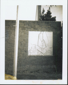
George Henry Allen (8 February 1900 – 12 October 1972) was an Australian sculptor and teacher, an official war artist in the latter years of the Second World War. He served as an official war artist with the rank of lieutenant from December 1943, working at Port Moresby and the Australian War Memorial, retired February 1945. The plaque by George Allen on the exterior wall of the north side of Kew Library commemorating WW2 was funded by a bequest from the late Mrs Annie Anderson.One of two black and white snapshots (polaroid photos) of George Allen's sculpture at Kew Library. Mavis Rolley wrote about the memorial in 1980 as: This impressive piece of Sculpture, a memorial to the sacrifice of those who served in the Second World War, was completed in 1960 to coincide with the One Hundred Centenary Year of the City of Kew, and was unveiled on Anzac Day of that year by the Hon. A.G. Rylah, Chief Secretary, Deputy Premier of Victoria. Mr. George Allen, sculptor, submitted the winning design and through the contribution of a generous bequest of the late Mrs. Annie Anderson, a former resident of Kew, the Municipal Office was able to commission this gentleman’s work. The memorial is mounted on a wall of granite blocks and carved in Sydney Freestone, depicting a scene of war and loved ones at home.war memorials -- kew (vic.), memorials -- world war 2. -- kew (vic.), george henry allen, artworks -- kew library -
 Friends of Ballarat Botanical Gardens History Group
Slide - Colour transparency, Eastman Kodak, c. 1940
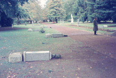
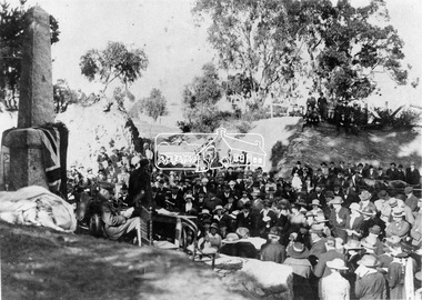
On March 2, 1940, Sir Winston Dugan, Governor of Victoria unveiled the busts of the six first prime ministers of Australia at a ceremony on the long avenue of Horse Chestnuts. The donor, Richard Armstrong Couch, was born in Ballarat in 1868.The Prime Ministers Avenue is a feature of national significance, set in the magnificent Horse Chestnut Avenue of the Gardens. The 28 Prime Ministers of Australia are displayed as bronze portraits mounted on polished granite pedestals. The collection includes a portrait of one of the founding fathers of Federation, Alfred Deakin, who was the first Federal Member for Ballarat and the second Prime Minister.Kodachrome slide depicting a pathway and lawns where pedestals and busts of the first six prime ministers are lying on the ground to be installed. A man with hat, long winter coat is standing on the pathway.Kodachromeballarat botanical gardens, trees, men, pathways, lawns, sculptures, busts, prime ministers avenue, chestnut trees, granite, alfred deakin, federation, horse chestnuts, richard armstrong crouch, pedestals, governor, sir winston dugan, wallace anderson -
 Ballarat Heritage Services
Photograph - Digital photographs, L.J. Gervasoni, Kew War Memorial and Cenotaph, c2017
Kew War Memorial is a fine example of a classical style war memorial design. Built in granite and marble as a circular temple supported on ionic columns, its design takes advantage of the centrally-located site and allows a clear view of all faces of the memorial. It honours 917 local residents who served in World War One. Kew Municipal Council appointed a sub-committee in June 1919 to consider a suitable war memorial to commemorate soldiers from the district. In August 1920 the land in front of the Post Office was transferred to the Council for the purpose. A competition for the design of the Memorial offered prizes of offered were £50, £15 and £10. The estimated cost was not to be more than £3500 F. Bruce Kemp won first prize, but Council later rejected the design constructing the Memorial to the original design of former Kew Council Mayor and notable Melbourne architect Harry W. Tompkins. The War Memorial was unveiled by His Excellency the Governor of Victoria, Lord Stradbroke on 30 August 1925 in front of 5,000 people. Digital images of the Kew War Memorial and the former Kew Post Office at Kew Junction at the intersection of High Street and Cotham Road.kew, war memorial, cotham road, high street, commemoration, kew junction, kew war memorial, kew post office, harry w. tomkins, cenotaph -
 Friends of Ballarat Botanical Gardens History Group
Slide - Colour transparency, Eastman Kodak, c. 1940
On March 2, 1940, Sir Winston Dugan, Governor of Victoria unveiled the busts of the six first prime ministers of Australia at a ceremony on the long avenue of Horse Chestnuts. The donor, Richard Armstrong Couch, was born in Ballarat in 1868.The Prime Ministers Avenue is a feature of national significance, set in the magnificent Horse Chestnut Avenue of the Gardens. The 28 Prime Ministers of Australia are displayed as bronze portraits mounted on polished granite pedestals. The collection includes a portrait of one of the founding fathers of Federation, Alfred Deakin, who was the first Federal Member for Ballarat and the second Prime Minister.Kodachrome slide depicting the gardens during the installation of the pedestals and busts of the first six prime ministers.Kodachromeballarat botanical gardens, trees, lawns, pathways, sculptures, busts, governors, prime ministers avenue, richard armstrong couch, federation, 1940, chestnut trees, horse chestnuts, bronze, granite, pedestals, alfred deakin, sir winston dugan, wallace anderson -
 Bendigo Historical Society Inc.
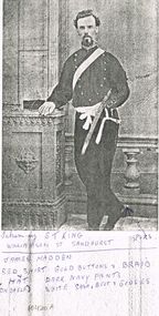
Photograph - PHOTOCOPY OF JAMES MADDEN IN UNIFORM
Photocopy of James Madden in uniform resting his right arm on a ledge and his right leg hooked behind his left leg. James is wearing a red shirt, with gold buttons and braid, dark navy pants with white sash from left to right, belt and gloves. James also has his sheathed sword being held in the crook of his left arm. His right boot indicates that he is wearing spurs.13 page typewritten letter written whilst aboard the SS. Orion on the Mediterranean Sea , 28 march 1938. The letter gives details of the sights and goods able to be purchased in the area. Small letter envelope with the name of Harcourt Granite Quarries J. Blight and Co., Proprietors, if not claimed within ten days to be returned to the Manager, printed in the bottom left corner.S. T. King Williamson Sandhurst.military, world war 2, james madden -
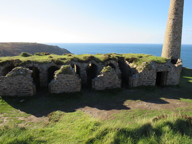
 The Beechworth Burke Museum
Photograph - Photograph - Reproduction, 1890-1900
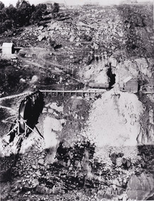
The photograph appears to depict the of the entrance to the Rocky Mountain Tunnel. The Rocky Mountain Tunnel runs from opening of the tunnel, underneath the Beechworth town, to the Gorge. This tunnel drained the excess water from the upper Spring Creek Goldfield to allow for mining access in the area. The Rocky Mountain Co. blasted through the granite rock to create the original 400ft-long tunnel in 1859, but between 1867 and 1871, the Rocky Mountain Gold Sluicing Co. widened and extended it. At its completion, it measured 14ft deep, 6ft wide, and almost half a mile long. The mining surveyor at Beechworth called it 'without doubt, the greatest undertaking of the kind in the colony'. When the company became the Rocky Mountain Extended Gold Sluicing Co. in the mid-1870s, they continued the tunnelling work. The work was reportedly vital to mining being able to continue at Beechworth and may have established world records in tunnelling through hard rock. The entrance at the Gorge side of the tunnel can be seen from the Beechworth Gorge Walk. The tunnel continues to be an outfall drain for the lake and the town.The search for gold is ingrained into the history of Victoria and therefore, images like this one which portray an open cut sluicing site can reveal important information for society and technology for the date when the photograph was taken. This image is of important historical significance for its ability to convey information about sluicing and the methods used to find gold in the late 1800s and early 1900s. It also shows a location where sluicing was undertook which provides insight into the impact of sluicing on the environment at a time when it was done. The Burke Museum is home to a substantial collection of Australian mining photographs which can be used to gain a deeper understanding into life on the gold fields, technology used in mining, the miners themselves and the impact of the gold digging on the environment.A black and white rectangular reproduced photograph printed on matte photographic paper.7814beechworth, beechworth museum, burke museum, australian museum, mining, rocky mountain mining co., rocky mountain mining company, mine, mining company, rocky mountain mine, mine entrance, rocky mountain, gold, gold mining -
 Blacksmith's Cottage and Forge
WW1 Table Cloth, WW1
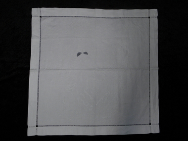
This signature table cloth was anonymously donated to the Bacchus Marsh Blacksmith Cottage and Forge group in 2013. On the cloth are the hand embroidered names of men who served in WW1 as well as the names of family members, place names and dates of significance. In one corner of the cloth is the outline of a tennis ball, in which 6 names are listed. Research has shown that these names probably belonged to the Rose Park Methodist Tennis Club in Adelaide. Many of the other names listed seem to relate to servicemen and their families who came from South Australia. Also on this cloth are 3 beautifully embroidered butterflies, the profile of a man, a crest containing the letters B and H and the following place names and dates :- Sydney 21.10.12, Melbourne Jan 13, Goolwa, Genolan Caves NSW, Katoomba, Luna Park St Kilda and Granite Island. The name of the steamship SS Warilda also appears on this cloth. this ship belonged to the Adelaide Steamship Company. It was used to transport soldiers to WW1 and was then converted into a hospital ship, ferrying the wounded from France to England. It was hit and sank on the 3rd of August 1918.World War 1 signature table cloth. A square, white, linen table cloth with hand embroidered signatures of people and names of places, dates and objects relating to WW1.The embroidery is all done in white thread.There are also 3 embroidered butterflies, a crest and a man's profile. -
 Friends of Ballarat Botanical Gardens History Group
Work on paper - Statue Valuations, Insurance Valuations of Public Sculptures, fountains and Monuments for the City of Ballarat, 1994, 11 April, 1994, 9/5/94 and 2012
Insurance valuations of public sculptures, fountains and monuments for the City of Ballarat: attention Ian Rossiter. (Town Clerk) valuations prepared by John Jones, Historian, Consultant, Valuer in Australian Art. Print--out contains valuations of the Statues in the Ballarat Botanical Gardens only and the criteria used for updating valuations. Unsigned though very likely written by John Garner.Important in knowing a valuation of each statue in the Ballarat Botanical Gardens in 1994.2 faxes, 1. 1page only. 2.7 pages and 1 copy of 3 pages,(Prime Ministers' busts). 1 page print- out and a copy Fax 1. 11 April 1994. Fax 2. is water damaged. Printed across the top of this fax 94-05-09 11:20 Fax No 6622400. Two folder ring marks on the left hand of each page of the faxes. Fax 2 is signed John Jones on p.6. No marks on print-out. statue valuations, statues of prime ministers, john jones, valuer, city of ballarat, ian rossiter, valuation criteria, value of the statues in the ballarat botanical gardens. total value of ballarat statues in 1994. lists of ballarat statues, sculptors, dates of when the statues were made, marble, slate, granite, bronze, sandstone, john garner collection, garner, dr, ballarat botanical gardens, gardens, ballarat -
 Bendigo Historical Society Inc.
Document - MYSTERY OF JOHN MCMAHON'S GRAVE BIG HILL
The Mystery of John McMahon's Grave, Big Hill mentions granite stone markers south of the Tunnel. Some believed he was buried there, but further research has found he is buried at the Kangaroo Flat Cemetery in the Roman Catholic section, Grave No. 1134 on 20 May, 1874. Also mentioned is his widow was appointed Gate Keeper at Ravenswood on 2 September, 1874. Also mentioned is the death of Frederick Benton, who died on 24 February, 1860 of peritonitis. There is a sepia? Photo taken of the Big Hill Tunnel (Bendigo side looking south) from Picture Australia c. 1875 and a coloured one of the Big Hill Tunnel Bendigo side (photo taken March, 2008). On page 2 are two coloured views at Big Hill for John McMahon, 850 metres south of Big Hill Tunnel entrance, Melbourne side/east of line (photos taken March, 2008).person, individual, john mcmahon, mystery of john mcmahon's grave, big hill, john mcmahon, big hill tunnel, mrs i marchesi, mr marchesi, mrs ivy irene marchesi (nee bone), sarah mcmahon, sarah mcewan (mckeown/mckeon), ravenswood station, kangaroo flat cemetery, sarah jane mcmahon, frederick benton, pictureaustralia, vic rail, melbourne to mount alexander-murray rail line, stone markers for john mcmahon -
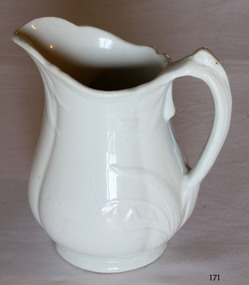 Flagstaff Hill Maritime Museum and Village
Ceramic - Jug, Baker & Co, 1891 to 1893
W Baker and Co-produced many different types of pottery at their Fenton Potteries, Stoke-on-Trent, Staffordshire England. The company was established in 1790 by Ralph Bourne and William Baker the company was working at capacity by the end of the century. By the late 1820's Bourne and Baker, in partnership with John Bourne, had acquired additional works opposite the first in 1833. With the deaths of John Bourne and William Baker, the partnership was dissolved, and then for a short time, the business was carried on by Ralph Bourne and William Baker junior and John Baker. By the early 1840s, William Baker was running it alone and was then using 'machinery for the potteries manufacturing operations in addition to the mill that was producing the raw clay. The business was subsequently carried on by William Baker and Company that were known for the making of printed, sponged, and pearl-white granite ware for export in the early 1880s at the Fenton works between Manor and Fountain Streets. The original works on the south side of City Road were by then an en-caustic tile works, apparently still in the hands of the Baker family. The pottery works flourished under William Baker’s management and by the middle of the nineteenth century with almost 500 employees was the biggest firm in Fenton. An early piece of ironstone Staffordshire pottery now a collector's item showing the types of domestic items that were exported from England to its colonies towards the end of the nineteenth century and into the beginning of the twentieth.Water pitcher ironstone ceramic white with raised embossed Lilly of the valley decoration around handle and lip sections. Marked on bottom, "Royal stone china, Baker and Co, England" with emblem of lion, crown and unicornflagstaff hill, warrnambool, shipwrecked coast, flagstaff hill maritime museum, maritime museum, shipwreck coast, flagstaff hill maritime village, great ocean road, jug, kitchen utensil, kitchen ware, water pitcher -
8th/13th Victorian Mounted Rifles Regimental Collection
Document
On Canberra Day held on 12 March 1988, a ceremony is conducted to commemorate the relocation of the Commencement Column Monument (also known as the Commemoration Stone) on Capital Hill. The Light Horse Heritage Troop of 8/13 Victorian Mounted Rifles supported the event. The monument was originally designed to have a 20 metre column to signify the Commonwealth. It was to be erected on a hexagonal base comprising six granite blocks, one from each of the original States of the Commonwealth, on the land axis between Capital Hill and Camp Hill. Whilst the column was never completed, the hexagonal base was constructed and, on 12 March 1913, three foundation stones were laid, by the then Governor-General Lord Denman, the Prime Minister Andrew Fisher, and the Minister of Home Affairs the Hon. King O'Malley, to commemorate the founding and naming of Canberra as the national capital. In 1981 the 63 stones making up the monument were removed from Capital Hill and stored prior to the commencement of excavation work for the new Parliament House. Following a Joint Standing Committee recommendation in 1987, the Commencement Column monument is relocated 'on the land axis immediately north of the parade ground associated with the new Parliament House'. Typed Administrative Instruction for A Squadron 8/13 VMR support to Festival of Canberra 10-13 March 1988. Four pages including nominal roll.Light Horse Troop provided mounted guard for the re-naming of Canberra ceremony and participated in Festival Parade. -
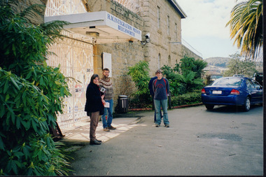 Wooragee Landcare Group
Photograph, 2004
This photo was taken in 2004 and pictures Luke Bailey and Glen Scholfield, the Wooragee Landcare Group coordinator, outside Beechworth Prison. This was the last year Wooragee Landcare Group met with Beechworth Prison Farm and Industry Managers at the prison itself, where they discussed weed and rabbit control on the prison's 'Rockery' block. The weed and rabbit controls that were explored in this event aimed to educate people on how to manage common pests in the Wooragee landscape and improve the appearance of the Beechworth Prison. The Beechworth prison itself is significant as it was built between 1859 and 1864 and is designed using a radiating 'panopticon' method which had proved an efficient, cost-effective design for easy surveillance of prisoners by allowing guards to watch over a large area from a central observation point. The prison is historically significant for its association with the early development of Beechworth as the government administrative centre of north-eastern Victoria. It is part of a major precinct of public buildings and has links to numerous other places in Beechworth which used granite quarried and broken at the prison by male inmates. It is also significant for its associations with the bushranger Ned Kelly and the Kelly storyThe photo holds significance due to the social and educational context the image holds in representing the events Wooragee Landcare Group held in order to educate the public. The photograph also exemplifies the historic significance of the area due to the Beechworth Prison's relation to important historical eras and events.Landscape coloured photograph printed on gloss paperReverse: WAN NA E0NA0N2. NN1- 1 2906 / [PRINTED] (No.15) / 870wooragee, wooragee landcare, wooragee landcare group, beechworth prison, h.m beechworth prison, beechwoth gaol, ned kelly, greg johnson, agriculture victoria, department of primary industries, dpi -
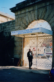 Wooragee Landcare Group
Photograph, 2004
This photo was taken in 2004 and pictures Greg Johnson, who worked at Agriculture Victoria (formerly known as the Department of Primary Industries, DPI), outside Beechworth Prison. This was the last year Wooragee Landcare Group met with Beechworth Prison Farm and Industry Managers at the prison itself, where they discussed weed and rabbit control on the prison's 'Rockery' block. The weed and rabbit controls that were explored in this event aimed to educate people on how to manage common pests in the Wooragee landscape and improve the appearance of the Beechworth Prison. The Beechworth prison itself is significant as it was built between 1859 and 1864 and is designed using a radiating 'panopticon' method which had proved an efficient, cost-effective design for easy surveillance of prisoners by allowing guards to watch over a large area from a central observation point. The prison is historically significant for its association with the early development of Beechworth as the government administrative centre of north-eastern Victoria. It is part of a major precinct of public buildings and has links to numerous other places in Beechworth which used granite quarried and broken at the prison by male inmates. It is also significant for its associations with the bushranger Ned Kelly and the Kelly storyThe photo holds significance due to the social and educational context the image holds in representing the events Wooragee Landcare Group held in order to educate the public. The photograph also exemplifies the historic significance of the area due to the Beechworth Prison's relation to important historical eras and events.Portrait coloured photograph printed on gloss paperReverse: WAN NA E0NA0N2. NNN- 3 2906 / [PRINTED] (No.13) / 868wooragee, wooragee landcare, wooragee landcare group, beechworth prison, h.m beechworth prison, beechwoth gaol, ned kelly, greg johnson, agriculture victoria, department of primary industries, dpi -
 The Beechworth Burke Museum
Geological specimen - Chalcopyrite
This specimen originated from Mount Lyell on the west coast of Tasmania, where a large group of open cut and underground copper-silver-gold mines began operating in 1883. Between 1893-1994, the Mt Lyell Mining and Railway Company were responsible for operations. The Mt Lyell copper-gold mines produce some excellent crystallised specimens of chalcopyrite and other minerals. The deposits are generally considered to be of Cambrian volcanic origin, but there are indications of Devonian granitic influence on the ores, plus local remobilisation during Devonian deformation. Over 120 million tonnes of ore was produced from several workings, including the main Prince Lyell mine and the North Lyell mine, which was also of great importance. The Mount Lyell mines have a long history of human and environmental disasters, including the 1912 North Lyell fire that killed 42 miners, and two separate incidents in 2013 in which three people lost their lives. The environmental impacts from this complex of mines are extensive, with waste tailings and heavy metal contamination flowing directly into the King and Queen River catchments. In 1954, the eminent Australian historian, Geoffrey Blainey, published 'The Peaks of Lyell' which delves into the history of the 1912 North Mount Lyell Disaster.Chalcopyrite does not contain the most copper in its structure relative to other minerals, but it is the most important copper ore since it can be found in many localities and occurs in a variety of ore types. The brassy-yellow colours in Chalcopyrite mean it is often confused with pyrites and gold, leading to use of the term, "fool's gold." Chalcopyrite has been the primary ore of copper since smelting began five thousand years ago. This specimen is part of a larger collection of geological and mineral specimens collected from around Australia (and some parts of the world) and donated to the Burke Museum between 1868-1880. A large percentage of these specimens were collected in Victoria as part of the Geological Survey of Victoria that begun in 1852 (in response to the Gold Rush) to study and map the geology of Victoria. Collecting geological specimens was an important part of mapping and understanding the scientific makeup of the earth. Many of these specimens were sent to research and collecting organisations across Australia, including the Burke Museum, to educate and encourage further study.This hand sized solid mineral specimen has shades of brass-yellow with spots of iridescent green-black tarnish. Chalcopyrite is a copper iron sulphide mineral and a major ore of copper common in sulphide veins and disseminated in igneous rocks. Chalcopyrite has a hardness of 3.5-4 on the Mohs Scale. It is a member of the tetragonal crystal system and has metallic lustre and opaque transparency.burke museum, beechworth, indigo shire, beechworth museum, geology, geological specimen, chalcopyrite, copper pyrites, copper mining, tasmanian geology, mount lyell, mount lyell mines, fools gold, mohs scale, crystals, minerals, historical geological collection, victorian geological survey, a.r.c selwyn, gold rush, van diemans land -
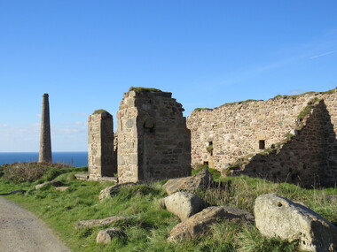
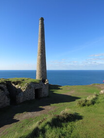
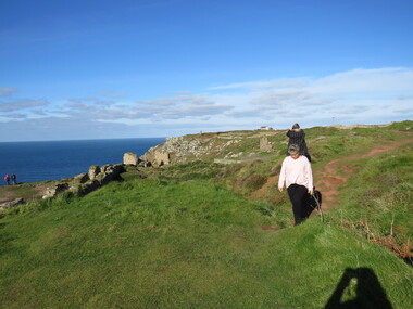
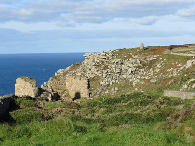
 Ballarat Heritage Services
Photograph - Colour, Dorothy Wickham, St Just, Cronwall, World Heritage Site
A stone’s throw from Land’s End, this is the most westerly Area of the Site. St Just is characterised by big skies, jagged rocks, stark moorland, and iconic clifftop engine houses perched above the Atlantic in some incredible locations. No wonder this dramatic setting has inspired generations of artists, writers and photographers. World-famous for their mineralogy, the mining sites here are extremely well preserved – as is the sense of community amongst the people whose lives they once dominated. This Area’s unique geography and mineralogy meant that undersea mining was more concentrated here than anywhere else in the world in the 18th and 19th centuries. The oldest surviving Cornish beam engine (constructed in 1840) remains in its original engine house at Levant, restored and still working under steam. Geevor, one of the last mines to close in Cornwall (1990), was saved from demolition and is now the largest metalliferous mine site open to the public in the UK. The historic mining town of St Just is home to characteristic rows of granite mine workers’ cottages, public squares, shops, cafés, art galleries and, just off Bank Square, a medieval grassed amphitheatre – the Plen an Gwary or ‘playing place’.st just, world heritage, ellis, penrose, cornwall, mining, mines -
 Ballarat Heritage Services
Photograph - Colour, Dorothy Wickham, St Just, Cornwall, World Heritage Site
A stone’s throw from Land’s End, this is the most westerly Area of the Site. St Just is characterised by big skies, jagged rocks, stark moorland, and iconic clifftop engine houses perched above the Atlantic in some incredible locations. No wonder this dramatic setting has inspired generations of artists, writers and photographers. World-famous for their mineralogy, the mining sites here are extremely well preserved – as is the sense of community amongst the people whose lives they once dominated. This Area’s unique geography and mineralogy meant that undersea mining was more concentrated here than anywhere else in the world in the 18th and 19th centuries. The oldest surviving Cornish beam engine (constructed in 1840) remains in its original engine house at Levant, restored and still working under steam. Geevor, one of the last mines to close in Cornwall (1990), was saved from demolition and is now the largest metalliferous mine site open to the public in the UK. The historic mining town of St Just is home to characteristic rows of granite mine workers’ cottages, public squares, shops, cafés, art galleries and, just off Bank Square, a medieval grassed amphitheatre – the Plen an Gwary or ‘playing place’.st just, world heritage,, ellis,, penrose, cornwall, mining, mines -
 Ballarat Heritage Services
Photograph - Colour, Dorothy Wickham, St Just, Cornwall, World Heritage Site
A stone’s throw from Land’s End, this is the most westerly Area of the Site. St Just is characterised by big skies, jagged rocks, stark moorland, and iconic clifftop engine houses perched above the Atlantic in some incredible locations. No wonder this dramatic setting has inspired generations of artists, writers and photographers. World-famous for their mineralogy, the mining sites here are extremely well preserved – as is the sense of community amongst the people whose lives they once dominated. This Area’s unique geography and mineralogy meant that undersea mining was more concentrated here than anywhere else in the world in the 18th and 19th centuries. The oldest surviving Cornish beam engine (constructed in 1840) remains in its original engine house at Levant, restored and still working under steam. Geevor, one of the last mines to close in Cornwall (1990), was saved from demolition and is now the largest metalliferous mine site open to the public in the UK. The historic mining town of St Just is home to characteristic rows of granite mine workers’ cottages, public squares, shops, cafés, art galleries and, just off Bank Square, a medieval grassed amphitheatre – the Plen an Gwary or ‘playing place’.st just, world heritage, ellis, penrose, cornwall, mining, mines -
 Ballarat Heritage Services
Photograph - Colour, Dorothy Wickham, St Just, Cronwall, World Heritage Site
A stone’s throw from Land’s End, this is the most westerly Area of the Site. St Just is characterised by big skies, jagged rocks, stark moorland, and iconic clifftop engine houses perched above the Atlantic in some incredible locations. No wonder this dramatic setting has inspired generations of artists, writers and photographers. World-famous for their mineralogy, the mining sites here are extremely well preserved – as is the sense of community amongst the people whose lives they once dominated. This Area’s unique geography and mineralogy meant that undersea mining was more concentrated here than anywhere else in the world in the 18th and 19th centuries. The oldest surviving Cornish beam engine (constructed in 1840) remains in its original engine house at Levant, restored and still working under steam. Geevor, one of the last mines to close in Cornwall (1990), was saved from demolition and is now the largest metalliferous mine site open to the public in the UK. The historic mining town of St Just is home to characteristic rows of granite mine workers’ cottages, public squares, shops, cafés, art galleries and, just off Bank Square, a medieval grassed amphitheatre – the Plen an Gwary or ‘playing place’.st just, world heritage, ellis, penrose, cornwall, mining, mines -
 Ballarat Heritage Services
Photograph - Colour, Dorothy Wickham, St Just, Cornwall, World Heritage Site
A stone’s throw from Land’s End, this is the most westerly Area of the Site. St Just is characterised by big skies, jagged rocks, stark moorland, and iconic clifftop engine houses perched above the Atlantic in some incredible locations. No wonder this dramatic setting has inspired generations of artists, writers and photographers. World-famous for their mineralogy, the mining sites here are extremely well preserved – as is the sense of community amongst the people whose lives they once dominated. This Area’s unique geography and mineralogy meant that undersea mining was more concentrated here than anywhere else in the world in the 18th and 19th centuries. The oldest surviving Cornish beam engine (constructed in 1840) remains in its original engine house at Levant, restored and still working under steam. Geevor, one of the last mines to close in Cornwall (1990), was saved from demolition and is now the largest metalliferous mine site open to the public in the UK. The historic mining town of St Just is home to characteristic rows of granite mine workers’ cottages, public squares, shops, cafés, art galleries and, just off Bank Square, a medieval grassed amphitheatre – the Plen an Gwary or ‘playing place’.st just, world heritage, ellis, penrose, cornwall, mining, mines -
 Bendigo Historical Society Inc.
Slide - Dunn's Rock Eppalock, 2012
The low rolling hills of the Kimbolton countryside consist of ancient, hard and fractured Ordovician rock up to 65 million years old, which was originally deposited deep under the sea. Rocks mainly are sandstone, mudstone, black shale and quartz conglomerates. Marine fossils can be found in the area. Around seven million years ago a basalt flow buried the original bedrock along the along the Campaspe River. Ongoing weathering, wind and water movement over the following years has produced younger clay, sand, silt and gravel deposits throughout the area. Patches of White Hills Gravel are also found in the area. Another unique geological feature of this area is the Permian Glacial Pavement rocks north and south of Eppalock and glacial sediments (such as “Dunn’s Rock” and “Kellams Rock”). During the ice age (up to 280 million years ago) large glaciers moving over the countryside, scoured out sediments, pulverized bedrock, polished and cut grooves into bedrock in the direction of ice movement. When the ice melted boulders etc where left behind in areas of entirely different rock types, such as a 100 Tonne granite block known as ‘The Stranger’ near Derrinal. Dunn's Rock (Glaciated Pavement) Eppalock - Photos of the rock and a field group collecting date with Lake Eppalock (Knowsley) in the backgroundhistory, bendigo, dunn's rock eppalock, kimbolton forest, lake eppalock, gately collection -
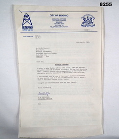 Bendigo Military Museum
Document - CENOTAPH RESTORATION BENDIGO, City of Bendigo, C.1984
This Document is the first in several plus photos and an article following the restoration of the Bendigo Cenotaph (Replica of the Cenotaph in Whitehall London). The letter is from the City of Bendigo Municipal Offices Lyttleton Terrace Bendigo is dated 13th April 1984 from the Building Surveyor Mr P.W. Phillips to Mr J.K. Barnes Secretary Bendigo RSL Sub Branch P.O.Box 449 Bendigo. Letter states that the Surveyors Report was adopted by Council on 21st November 1983 and would then be considered at Estimates later in the year. The Surveyors Report pages 2/3 gives a background report back to 1976 re its condition by the Building Surveyor at the time Mr R.H. Chellow and that an offer to fund at no cost was offered. Unfortunately this did not proceed. Council had approved funds for Stone work etc in the 1976/77 Estimates. The report is under several headings “Restoration of Cenotaph” being the history to this point. “Nature of Repairs Neccessary” - in brief, Extensive repairs, Granite structure is good, Sandstone needs 90% replacement, brick core in good order. “Estimate of Cost” A price of $30,000 for Budget purposes but could be as low as $25,000. “Recommendation” That Restoration be referred to the 1984/85 Estimates for consideration, copies to Bendigo RSL and State President RSL.Document 3 pages stapled together, front page is A4 and the pages 2/3 is Foolscap.Front page has a top section in blue, on the left is a depiction of a Mine Poppet Head, on the right is a Coat of Arms. The letter section is in black type, signed at the bottom in blue pen. Pages 2/3 are all black print.Page 1 points, Coat of Arms, “City of Bendigo - Progress”. “1968/84” - PWP:LT 32.7.1”. Page 2/3, “Building Surveyors Report - 21st November 1983 - B42/83 - (32.7.1)”brsl, smirsl, cenotaph, restoration -
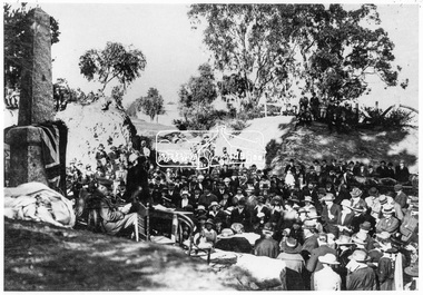 Eltham District Historical Society Inc
Negative - Photograph, Unveiling of War Memorial Obelisk, corner of Main Road and Bridge Street, Eltham
The unveiling of the Eltham Obelisk War Memorial was performed by the Rev. Padre Charles Tregear, assisted by Church of England vicar, Mr Safsford on August 3, 1919. Reproduced page 99 of "Pioneers & Painters." "Beneath a lonely pine tree on the hill crest out from Eltham, where the Greensborough Road junctions with the main Melbourne Road, Eltham has erected an everlasting tribute to the memory of the fallen heroes of the district. It is an obelisk of Harcourt granite in the rough, bearing an appropriate inscription and 27 names—an unpretentious monument by the wayside, which will stand for all time silently expressing the appreciation of the living for the sacrifice of the dead. The obelisk stands 14 feet high. ... Representatives of every house in the town, and many people from the surrounding district, gathered around the obelisk for the opening ceremony. The spring-like sunshine of the afternoon attracted everybody out of doors. There must have been 700 people present when the Lieutenant-Governor, Sir William Irvine, removed the draping of flags and revealed the names on the obelisk, the base of which was surrounded by wreaths and branches of wattle bloom, placed there by parents whose sorrow at the loss of sons was blunted, for the day at least, by feelings of pride. .." Age, Monday 4 August 1919, page 8 This was the memorial's orginal location. It has been relocated numerous times.This photo forms part of a collection of photographs gathered by the Shire of Eltham for their centenary project book,"Pioneers and Painters: 100 years of the Shire of Eltham" by Alan Marshall (1971). The collection of over 500 images is held in partnership between Eltham District Historical Society and Yarra Plenty Regional Library (Eltham Library) and is now formally known as the 'The Shire of Eltham Pioneers Photograph Collection.' It is significant in being the first community sourced collection representing the places and people of the Shire's first one hundred years.Digital image 4 x 5 inch B&W Negsepp, shire of eltham pioneers photograph collection, eltham, main road, bridge street, eltham war memorial, obelisk, obelisk corner -
 Eltham District Historical Society Inc
Negative - Photograph, Unveiling of War Memorial Obelisk, corner of Main Road and Bridge Street, Eltham, 3 Aug. 1919
The unveiling of the Eltham Obelisk War Memorial was performed by the Rev. Padre Charles Tregear, assisted by Church of England vicar, Mr Safsford on August 3, 1919. Reproduced page 99 of "Pioneers & Painters." "Beneath a lonely pine tree on the hill crest out from Eltham, where the Greensborough Road junctions with the main Melbourne Road, Eltham has erected an everlasting tribute to the memory of the fallen heroes of the district. It is an obelisk of Harcourt granite in the rough, bearing an appropriate inscription and 27 names—an unpretentious monument by the wayside, which will stand for all time silently expressing the appreciation of the living for the sacrifice of the dead. The obelisk stands 14 feet high. ... Representatives of every house in the town, and many people from the surrounding district, gathered around the obelisk for the opening ceremony. The spring-like sunshine of the afternoon attracted everybody out of doors. There must have been 700 people present when the Lieutenant-Governor, Sir William Irvine, removed the draping of flags and revealed the names on the obelisk, the base of which was surrounded by wreaths and branches of wattle bloom, placed there by parents whose sorrow at the loss of sons was blunted, for the day at least, by feelings of pride. .." Age, Monday 4 August 1919, page 8 This was the memorial's orginal location. It has been relocated numerous times.This photo forms part of a collection of photographs gathered by the Shire of Eltham for their centenary project book,"Pioneers and Painters: 100 years of the Shire of Eltham" by Alan Marshall (1971). The collection of over 500 images is held in partnership between Eltham District Historical Society and Yarra Plenty Regional Library (Eltham Library) and is now formally known as the 'The Shire of Eltham Pioneers Photograph Collection.' It is significant in being the first community sourced collection representing the places and people of the Shire's first one hundred years.Digital image 4 x 5 inch B&W Neg Print 9 x 12.5cmsepp, shire of eltham pioneers photograph collection, eltham, main road, eltham war memorial, bridge street, obelisk, obelisk corner -
 The Beechworth Burke Museum
Photograph - Lantern Slide, c1900
This image depicts people walking down the street in the early 1900s, giving a glimpse into everyday life of the Edwardian era in rural Australia. The image also captures the Beechworth Post Office, located on the corner of Ford and Camp Streets. The stone post office building was built in 1858 to replace the inadequate wooden building on the same location. It was built from granite sourced from the area and features Architectual designs of the era including a hipped slate roof and a colonnaded entrance surmounted by a parapet. Lantern slides, sometimes called 'magic lantern' slides, are glass plates on which an image has been secured for the purpose of projection. Glass slides were etched or hand-painted for this purpose from the Eighteenth Century but the process became more popular and accessible to the public with the development of photographic-emulsion slides used with a 'Magic Lantern' device in the mid-Nineteenth Century. Photographic lantern slides comprise a double-negative emulsion layer (forming a positive image) between thin glass plates that are bound together. A number of processes existed to form and bind the emulsion layer to the base plate, including the albumen, wet plate collodion, gelatine dry plate and Woodburytype techniques. Lantern slides and magic lantern technologies are seen as foundational precursors to the development of modern photography and film-making techniquesThis glass slide is significant because it provides insight into Beechworth's social amenities and religious infrastructure in the late Nineteenth Century. It is also an example of an early photographic and film-making technology in use in regional Victoria in the time period.Thin translucent sheet of glass with a square image printed on the front and framed in a black backing. It is held together by metals strips to secure the edges of the slide.burke museum, beechworth, lantern slide, slide, glass slide, plate, burke museum collection, photograph, monochrome, 1900s, edwardian era, architecture, granite building -
Bendigo Historical Society Inc.
Document - MINING IN BENDIGO COLLECTION: UNEARTHED QUARTZ CRUSHER
Typed notes mentioning the early pioneers of Bendigo Gold Mining. Some of them are: Messrs Ballerstedt, Wittschiebe, Luffsman, Roeder Lazarus, Kock, Hildebrandt, Bruhn,Miller, Annear, Wells, Rae,Jackson, Woodward, Sterry, Burrowes, Thorp, Heine, Holmes, Gould, Allen, Brooks, Watson and Geo Lansell. In 1911 a quartz crusher was unearthed in McCrae Street during excavations at the site of the new St.Kilian's Girls Club Rooms. It was used by the late Mr. James Irons. It was found at a depth of ten feet. Mr. Angus Kennedy, who believed that he manufactured the plant for Mr. Irons, said Mr. Irons used to crush very rich quartz from the Sheepshead Reef, south of the Big Blue Battery. Some years ago, a solid granite stone-crusher was seen at Diamond Hill. It was at the site of the old Diamond Hill Hotel. The Comet Reef was found by Mr. Driesslau, who found gold in an outcrop when he was shooting parrots. Also mentioned is the tunnel that goes right through Diamond Hill.document, gold, mining in bendigo, mining in bendigo, unearthed quartz crusher, messrs ballerstedt, wittschiebe, luffsman, roeder lazarus, kock, hildebrandt, bruhn, miller, annear, wells, rae, jackson, woodward, sterry, burrowes, thorp, heine, holmes, gould, allen, brooks, watson, geo lansell, bendigo advertiser april 28th 1911, st kilian's girls' club rooms, mr james irons, mr angus kennedy, sheepshead reef, big blue battery, diamond hill hotel, victoria proprietary ltd., comet reef, mr driesslau, diamond hill tunnel -
 Bendigo Historical Society Inc.
Photograph - Abbott family group, 1895
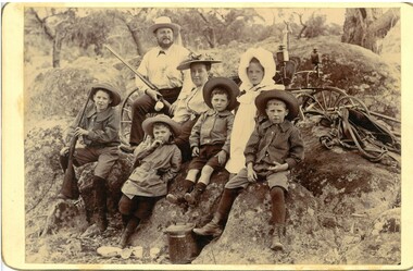
Richard Hartley Smith Abbott, company director, was born, probably in Bendigo, Victoria, around 1859, the son of Richard Hartley Abbott, also a company director, and Ann, née Smith. The young Richard was educated at Bendigo High School and then at St Andrews, Scotland. Returning to Australia, he became proprietor of the Abbott Supply Company, a director of the Sandhurst Building Society, the Bendigo Gas Company, and several local mining enterprises. He owned farms at Lyell, Mandurang and Eppalock, and was a pioneer of lucerne cultivation and tanning. In 1887, Abbott became a councillor for Strathfieldsaye Shire, a position he held for fifteen years. He was shire president (1901–02) and a Bendigo City councillor (1904–09; 1913–19), serving as Mayor of Bendigo between 1917 and 1918. Richard died in 1940. https://biography.senate.gov.au/richard-hartley-smith-abbott/ 'Preston Vale' was a property in Sedgewick. A sepia photo taken at Preston Vale of the Abbott family in 1895 including Richard Hartley Smith Abbott (Snr.) Mary Hannah (Gibbs) Abbott and their five oldest children, Richard Hartley Abbott born 1885, Inez Marie Abbott born 1886, William Norman Abbott born 1888, Harold Athelstone Abbott born 1889, and Kenneth Cyril Abbott born 1890. Two of the boys are wearing long sleeved striped collared shirts, one a scouting style coat and the youngest a collared shirt and all boys are in short pants with socks or stockings. Inez, is in a long sleeved dress with white smock with white bonnet. She is wearing boots. All others are wearing hats, Mrs Abbott's hat has a scrunched/folded ribbon on the brim. She is wearing a long sleeved light coloured blouse fastened at the neck The group is seated on an outcrop of granite rocks with parts of a buggy and horse tackle showing behind them. A lidded billy and scattered cups are on the ground in front. Mr Abbott, in shirt and long pants, is carrying a shot gun as is one of the boys. Both photos have 'Preston Vale Dec 26/95' written in ink on the reverse.abbott family, preston vale -
 City of Ballarat
Artwork, other - Public Artwork, Ex-Prisoners of War Memorial by Peter Blizzard, 2004
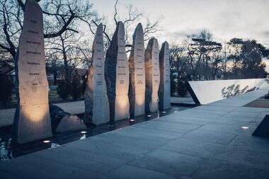
This memorial designed by Peter Blizzard is dedicated to more than 36,000 Australian men and women were held captive as prisoners by the enemy during the Boer War, World War 1, World War 2 and the Korean War. This memorial honours and names them, the names are etched into the black granite wall adjacent to the pathway. Water springs from beneath the 'Lest We Forget' stone then flows down the wall into the narrow watercourse in front of the first group of names and into the reflective pool, then continues past the second group of names. Finally it disappears under the pathway, returning to its source under the 'Lest We Forget' stone to start the journey again. Water symbolizes the essential nature of man, sacrifice, suffering, spirituality, healing, cleansing, birth and re-birth. The memorial is created from natural materials and is designed to be in harmony with the Ballarat Botanical Gardens, and to create a sense of timeless, dignity and respect. The long pathway of the monument is designed to create a visual perspective of the large distances that Australians travelled to the various conflicts. The paving is shaped like railway sleepers in recognition of the role that railways and railway journeys were relevant to many prisoners of war. The Memorial was declared the first military memorial of national significance located outside Canberra in 2008. Dedication services are held at the memorial on the Sunday closest to 6th of February, ANZAC day and on Remembrance Day. The memorial is of historical and aesthetic importance to the people of BallaratMonument made from carved bluestone, water feature and flagsInscribed with the names of 36,000 Australian men and women were held captive as prisoners by the enemy during the Boer War, World War 1, World War 2 and the Korean War. The listing is by surname and initials and shown by war.prisoners of war, boer war, world war 1, world war 2, korean war, lest we forget, peter blizzard -
 Ballarat Heritage Services
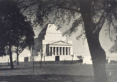
Photograph - Image, Shrine of Remembrance, Melbourne, c1934, 1934
The design for the Shrine of Remembrance was selected by competition among Australian artists and architects. Eighty-three designs were submitted and the winning design was by two Melbourne returned-soldier architects, Philip Hudson and James Wardrop. The inspiration for the external outline came from one of the seven wonders of the ancient world—the mausoleum at Halicarnassus to Mausolus, King of Caria in South West Asia Minor. Although the country was faced with frightful unemployment and financial difficulty in the late 1920s and the 1930s, so great was the gratitude of the people that the huge amount required to build the Shrine was raised or promised within six months from the opening of the appeal in 1928. (https://www.shrine.org.au/About-Us/History) Lodge Bros were commissioned to build the Shrine of Remembrance in St Kilda Rd in the late 1920s. In 1947, Lodge Bros were manufacturing a further stage at the Shrine of Rememberance, that being the carving and fixing of the bluestone servicemen on the top of the 1939-1945 War Memorial at the Eternal Flame. When funding became available for the new undercroft development at the front of the Shrine in 2001, the Shrine Trustees were eager to explore the possibility of the original stonemasons who built the Shrine, to complete the new development. This came to fruition in 2002-2003 when Lodge Bros constructed all the exterior walls of the undercroft development. Phil Luchetta (Managing Director) was able to source and secure the use of the same granite from Tynong Victoria that was used in the original works of the 1930s.Photograpic image of Melbourne's Shrine of Remembrance.shrine of remembrance, melbourne, war memorial, lodge brothers, world war one, remembrance -
 Hepburn Shire Council Art and Heritage Collection
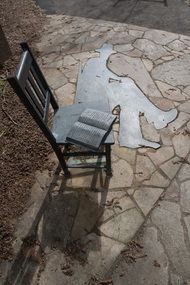
Public Art Work, Petrus Spronk, 'Memory of Place' - Petrus Spronk. 2000, 2005
Local Artist CV Artist StatementSignificant artwork by nationally renowned local artist Petrus Spronk.Large Scale Outdoor Sculpture made up of a bronze chair with an open book, a bronze shadow and 6 story rocksArtist signature - underneathlocal artist, petrus spronk, sculpture, public art, victoria, daylesford, mineral springs reserve, environmental art, hepburn shire public art collection, hepburn shire, hepburn springs, hepburn springs mineral reserve, bronze, granite, tourist attraction, art, clare gervasoni, joan mcewen, marie butler, laurie sullivan, bonnie howell, vera, lutea, merv keating, silent