Showing 572 items
matching land surveyed
-
 City of Moorabbin Historical Society (Operating the Box Cottage Museum)
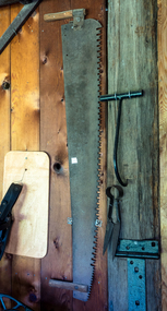
Tools, large Saw, 2 man, c1900
Early settlers had to clear the land of trees and shrubs to establish and maintain their farms and market gardens. Some settlers worked in the Gippsland region felling timber for transport by bullock wagons to Melbourne. Two-man crosscut saws were primarily important when human power was used. Such a saw would typically be 1 to 4 m (4 to 12 feet) long, and sometimes up to 5 m (16 feet), with a handle at each end. The technique in using a two-man saw involved a sawyer standing at each end and together the sawyers would alternate pulling the saw through the wood. If the kerf -slit- began closing, causing the saw to bind, wedges would be inserted behind the saw blade in order to keep the kerf open.Two-man saws were designed to cut in both directions. Careful tooth design was necessary to clear the sawdust during the cut. This is a typical two-man tree felling saw that was necessary to clear the land when the pioneers were establishing their market gardens and farms in Parish of Moorabbin c1850A long steel blade saw with 2 wood handles c1900tools, saws, axes, early settlers, pioneers, market gardeners, dairy farms, orchards, vineyards, timber mills, bullock wagons, tree felling, timber mills, city of moorabbin, county of bourke, moorabbin roads board, parish of moorabbin, shire of moorabbin, henry dendy's special survey 1841, were j.b.; bent thomas, o'shannassy john, king richard, charman stephen, highett william, ormond francis, maynard dennis, -
 City of Moorabbin Historical Society (Operating the Box Cottage Museum)
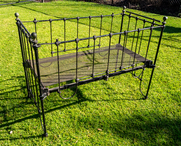
Furniture - Iron Cot, Belonging to the Box family, 19thC
This Cot was used by the family of William 1834-1902 and Elizabeth Box 1835- 1912 who in 1868 purchased 2 Lots of 10acres of the land that was part of the 'Henry Dendy Special Survey 1841' They established a market garden and raised 12 children while living in Box Cottage. William and Elizabeth Box established a flower garden on 2 lots of the 'Henry Dendy Special Survey 1841' and raised their family living in Box Cottage . A wrought iron cot with spaced vertical bars and with clamps on one side to secure when lowering and raising. The steel mesh base can be removed and wheels are attached to the base of the 4 postswilliam box, box cottage, moorabbin -
 City of Moorabbin Historical Society (Operating the Box Cottage Museum)
Document,leaflet 'Brief History of the City of Moorabbin 1850 - 1934', 2015
2015 CMHS members D. Maynard. Fran & Holger Bader compiled this Leaflet to provide a condensed information Leaflet about the origin and development of the area known as 'The City of Moorabbin' from 1850 -1994. Topics ; Aboriginal Bunurrung people, Henry Dendy's Special Survey 1841 in County of Bourke ; J.B Were, land agent, Pastoralists/ Squatters John O'Shannassy, Richard & John King, Moysey Family, Alexander MacDonald; Parish of Moorabbin Land Developers 1850 J.Holloway, A. Balcombe, D.Wickham, S. Charman, Keys Family; Road District of Moorabbin 1862 - 1870; Shire of Moorabbin 1871 - 1934; City of Moorabbin 1934 - 94; Amalgamation of Councils 1994 divided the City of Moorabbin between the Cities of Glen Eira, Bayside, Kingston and Monash; Origin of suburb names,This Leaflet was compiled in 2015 to provide a condensed history of the area known as 'The City of Moorabbin' for visitors , schools and local community1 x A4 printed both sides, black and white, folded x 3page 1 'BRIEF HISTORY OF THE CITY OF MOORABBIN' ; CITY OF MOORABBIN /1934-1994 page 2 'CITY OF MOORABBIN / 1934 - 94 city of moorabbin, county of bourke, moorabbin roads board, parish of moorabbin, shire of moorabbin, henry dendy's special survey 1841, were j.b.; bent thomas, o'shannassy john, king richard, charman s, highett william, ormond francis, maynard dennis, -
City of Moorabbin Historical Society (Operating the Box Cottage Museum)
Document, leaflet Box Cottage Museum, Bambra Press Ltd, 2019
Reprint 2019 by Bambra Press Ltd; Original Print 2016 This Leaflet / Brochure was compiled by City of Moorabbin Historical Society members Carol Poole, Joan Moore, Fran Bader for distribution to visitors, schools, libraries and local community to promote knowledge of Box Cottage Museum and the early settlement in the Moorabbin area. Glen Eira City Council Community Grant 2016 was obtained to finance printing by MKR Printing Ltd. Carnegie. Topics Box Cottage Museum, City of Moorabbin Historical Society, 1918 Chinese silk wedding dress, contact details, map, Box Family, Rietman Family, Land tenure records, Henry Dendy Special Survey 1841Reprint 2019, Original print 2016 Leaflet/Brochure compiled by CMHS members for distribution to visitors, schools, local community to promote knowledge of Box Cottage Museum and early settlement in the Moorabbin area1 x A4 glossy, colour, printed on both sides with photographsPage 1 BOX COTTAGE MUSEUM Page 2 William & Elizabeth Box, Land, August Rietman & Familycity of moorabbin, brighton, dendy henry, box william, box elizabeth, rietman august, rietman frieda, box cottage museum ormond, box alonzo, glen eira city council, city of moorabbin historical society, ormond, bentleigh, cheltenham, bambra press ltd port melbourne, -
 City of Moorabbin Historical Society (Operating the Box Cottage Museum)
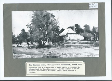
Photograph, B/W Watercolour,'Spring Grove' Charman Cottage built c1855 E Barlow c 1900, Elsie Barlow, c1900
This is a B/W photograph of a Water colour by Elsie Barlow c 1900. The original water-colour is in the collection of the Beaumaris and District Historical Trust in the State Library of Victoria. 'Spring Grove' was the home of the Charman family in the Parish of Moorabbin. Stephen Charman, aged 21years, arrived in Melbourne in 1842 as one of Henry Dendy's Emigrants. 1852 he purchased 160 acres for £328 bounded by Charman Rd and Balcome Rd. 'The Spring' was an important water source for the local Aboriginal people and then for the early settlers. Charman's first wife Harriet and their infant child died and in 1850 he married a widow with 5 children, Mary Gettens. Their first home was made of wattle and daub and they had 7 more children. Later a weatherboard cottage was built c 1855 Together they developed a market garden and specialized in marigolds which were sold for medicinal purposes to the Melbourne Chemists - Martin & Pleasance . The first Methodist Church Services were held at Spring Grove and the Charmans donated land in 1857 for the first Chapel, Cemetery and Primary School . Mary died 1870 and Stephen married again and moved to Gippsland where he died aged 85 in 1906Stephen and Mary Charman were pioneer market gardeners in Moorabbin Shire 1842 and were involved in the development of Church, school and community in the area now called Cheltenham. Charman Road Cheltenham was a boundary of their land. Black & White photograph of a Watercolour of Charman family cottage built 1885 Cheltenham Signed E Barlow on back ; A Cottage in Charman Road - the Dandelion Season / by Elsie Barlow / In the Collection of the State Library Victoria / Reproduction requires the permission of the Library Moorabbin Standard Newspaper moorabbin, cheltenham, dendy henry, dendy's special survey 1841, assisted emigrants early settlers, pioneers, market gardeners, marigold flowers, pharmacy, charman stephen, gettens mary, charman harriet, methodist church, primitive methodists, box william, box elizabeth, state schools, education, moorabbin shire, moorabbin roads board, city of moorabbin, kingston city council -
 City of Moorabbin Historical Society (Operating the Box Cottage Museum)
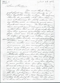
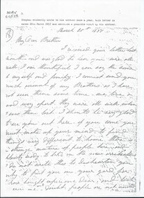
Document, Photocopy Letter Stephen Charman to Michael Charman UK 1853, 1853
Stephen Charman, aged 21 years arrived in Melbourne in 1842 as one of Henry Dendy's emigrants. He established purchased land in 1852 and established a market garden at Spring Grove Cheltenham with his 2nd wife Mary nee Gettens. Stephen died 1906 in Gippsland. He wrote letters to his brother Michael who had remained in England Stephen and Mary Charman were pioneer market gardeners in Moorabbin Shire 1842 and were involved in the development of Church, school and community in the area now called Cheltenham. Charman Road Cheltenham was a boundary of their land. Letter, handwritten from Stephen Charman to his brother Michael in UK 1853 x 3 pages Handwritten signed Stephen early settlers, pioneers, spring grove, city of moorabbin, county of bourke, moorabbin roads board, parish of moorabbin, shire of moorabbin, henry dendy's special survey 1841, were j.b.; bent thomas, o'shannassy john, king richard, charman stephen, charman mary, gettens mary, marigold flowers, pharmacy, methodist church, state schools, education, highett william, ormond francis, maynard dennis, market gardens, -
 City of Moorabbin Historical Society (Operating the Box Cottage Museum)
Document, Photocopy Letter Stephen Charman to Michael Charman UK 1857, 1857
Stephen Charman, aged 21years, arrived in Melbourne in 1842 as one of Henry Dendy's Emigrants. 1852 he purchased 160 acres for £328 bounded by Charman Rd and Balcome Rd. 'The Spring' was an important water source for the local Aboriginal people and then for the early settlers. Charman's first wife Harriet and their infant child died and in 1850 he married a widow with 5 children, Mary Gettens. Their first home was made of wattle and daub and they had 7 more children. Later a weatherboard cottage was built c 1855 Together they developed a market garden and specialized in marigolds which were sold for medicinal purposes to the Melbourne Chemists - Martin & Pleasance . The first Methodist Church Services were held at Spring Grove and the Charmans donated land in 1857 for the first Chapel, Cemetery and Primary School . Mary died 1870 and Stephen married again and moved to Gippsland where he died aged 85 in 1906 Stephen and Mary Charman were pioneer market gardeners in Moorabbin Shire 1842 and were involved in the development of Church, school and community in the area now called Cheltenham. Charman Road Cheltenham was a boundary of their land. Letter, handwritten from Stephen Charman to his brother Michael in UK 1857 x 3 pageshandwrittenmoorabbin, cheltenham, dendy henry, dendy's special survey 1841, assisted emigrants, early settlers, pioneers, market gardeners, marigold flowers, pharmacy, charman stephen, gettens mary, charman harriet, methodist church, primitive methodists, box william, box elizabeth, state schools, education, moorabbin shire, moorabbin roads board, city of moorabbin, kingston city council, charman michael, cancel -
 City of Moorabbin Historical Society (Operating the Box Cottage Museum)
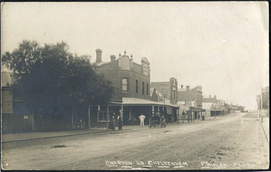
Photographs , Postcards x4 Charman Rd Cheltenham c 1910, c1910
After the arrival of the Cheltenham Railyway Station Charman Road became the main shopping centre. From 1 small shop - Mrs Meeres who sold sweets, school requisites and drapery - it proceeded to develop throughout the 1890's with various traders until the 1910 Postcards show many shops on both sides of the road, Stephen Charman, aged 21years, arrived in Melbourne in 1842 as one of Henry Dendy's Emigrants. 1852 he purchased 160 acres for £328 bounded by Charman Rd and Balcome Rd. 'The Spring' was an important water source for the local Aboriginal people and then for the early settlers. Charman's first wife Harriet and their infant child died and in 1850 he married a widow with 5 children, Mary Gettens. Their first home was made of wattle and daub and they had 7 more children. Later a weatherboard cottage was built c 1855 Together they developed a market garden and specialized in marigolds which were sold for medicinal purposes to the Melbourne Chemists - Martin & Pleasance . The first Methodist Church Services were held at Spring Grove and the Charmans donated land in 1857 for the first Chapel, Cemetery and Primary School . Mary died 1870 and Stephen married again and moved to Gippsland where he died aged 85 in 1906 Stephen and Mary Charman were pioneer market gardeners in Moorabbin Shire 1842 and were involved in the development of Church, school and community in the area now called Cheltenham. Charman Road Cheltenham was a boundary of their land.4x Black & White Postcards c 1910 of Charman Road Cheltenham VictoriaFront; CHARMAN RD. CHELTENHAM P. FAIRLAM PHOTOfairlam p, cheltenham railway station, moorabbin, cheltenham, dendy henry, dendy's special survey 1841, assisted emigrants early settlers, pioneers, market gardeners, marigold flowers, pharmacy, charman stephen, gettens mary, charman harriet, methodist church, primitive methodists, box william, box elizabeth, state schools, education, moorabbin shire, moorabbin roads board, city of moorabbin, kingston city council, cancel, cheltenham primary school -
 City of Moorabbin Historical Society (Operating the Box Cottage Museum)
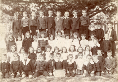
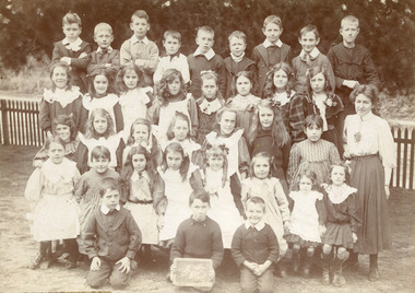
Photograph, 2 x Black & White Beaumaris State School , Miss Reynolds 1906, 07, 1906, 1907
Teacher Miss Reynolds is shown with her 'Upper Class' in 1906 and '2nd Class' in 1907. West Beaumaris School No 84 in Charman Road Stephen Charman, 1821-1906 a market gardener, donated land for the first Methodist Chapel, Cemetery and School in Charman Rd Cheltenham 1855. The enrolment was 36 pupils with Mr Frederick Meeres as Teacher. 1863 the school is called Beaumaris Common School No 84 with 70 pupils and Walter Meeres as Teacher. 1869 another 2 acres in Charman Road were granted by the Education Board and brick building built . 1872 State School 84 Beaumaris was increasing enrollments and 1878 a new brick school was built to accommodate 174 pupils and the name changed to Cheltenham State School No.84 1894 Mentone State School No.2950 amalgamated with Cheltenham SS No.84. 1910 the buildings were in disrepair, overcrowding was increasing and renovations were made 1912 with further additions in 1925 and 1937. Post WW11 extra prefabricated Classrooms were added as enrollment increased to 1038 in 1955.. Cheltenham East State School 4754 was opened as housing development spread over the City of Moorabbin . ( J Larson Sandringham HS)1855 Stephen Charman donated land to the Methodist Church so that a School could be established to educate the children of the early settler market gardeners and farmers in the Cheltenham area . Education was valued by the general community and as well as schools they established mechanics Institutes and Libraries in Moorabbin Shire. Cheltenham State School No. 84 was among the first schools in Melbourne.2 x Black & White Photographs of Beaumaris State School pupils with Miss Reynolds in 1906 and 1907Hand written ; Warburton, B. Wooff, R. Whelan, Miss Reynoldscity of moorabbin, county of bourke, moorabbin roads board, parish of moorabbin, shire of moorabbin, henry dendy's special survey 1841, were j.b.; bent thomas, o'shannassy john, king richard, charman stephen, highett william, ormond francis, maynard dennis, cheltenham state school no.84, methodist chapel cheltenham, methodist school cheltenham, beaumaris west state school, meeres frederick, meeres walter, education, early settlers, -
 City of Moorabbin Historical Society (Operating the Box Cottage Museum)
Photographs,x3 Colour Early Weatherboard Cottage Cheltenham c1880, 1981
Henry Dendy , a farmer from Sussex England, purchased 5,120 acres of land in the area of a 'Special Survey 1841' that extended from Brighton bayside North Road, East Boundary Rd to South Road. This area became known as Dendy's Brighton and as part of the sale 139 emigrant workers arrived in 1842 however Dendy was unable to find work and lodgings for these people. J.B.Were, financier took over the management of the 'Special Survey 1841' area and began to sell and lease allotments. 1850 the Squatter King brothers sold land south of Dendy's 'Special Survey 1841' to Josiah Holloway who sectioned it into 2 acre lots @ £10 each for market gardens - 'Two Acre Village' and Charles Whorral opened a small hotel - 'The Cheltenham Inn' on the main Road - Arthur's Seat Rd, later Point Nepean Rd, now Nepean Highway. Notable settlers who moved into the area were Keys, Charman, Bruton, Le Page, Fairlam, Meeres and 1862 saw the separation from Brighton and the formation of the Mooorabbin Roads Board District. .By 1879 1000settlers were living in 'Cheltenham' serviced by a Post Office with Bank, Mechanics Institute, State School No 84,Keys Hotel, Meeres Store, Sir Thomas Bent ensured the new Railway Line from Caulfield to Mordialloc went through his constituency of Cheltenham 1881 and this changed the development to the bayside area of Cheltenham away from the 'Two Acre Village ' side causing some dissention, However Cheltenham as whole prospered and this house in Pine St is typical of the cottages built c 1890- 1900 in the area. This weatherboard house c 1890-1900 in Pine St Cheltenham is typical of those built for early settler families. Photo taken 1981 by CMHS member 3 x Colour photographs of an early c 1900 weatherboard house in Pine St Cheltenham taken by CMHS member 1981Kodak Aug. 81 / Handwritten Pine St Cheltenhamkeys robert, holloway josiah, king brothers, smith j l; smith mary ann, stanley helen, chaff cutter, horse drawn carts, toll gates brighton, motor cars 1900, steam engines, early settlers, bentleigh, parish of moorabbin, city of moorabbin, county of bourke, moorabbin roads board, shire of moorabbin, henry dendy's special survey 1841, were j.b.; bent thomas, o'shannassy john, king richard, charman stephen, highett william, ormond francis, maynard dennis, market gardeners, vineyards, orchards -
 City of Moorabbin Historical Society (Operating the Box Cottage Museum)
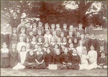
Photograph - Photograph, Black & White Cheltenham State School No. 84 1908, c1908
Stephen Charman, 1821-1906 a market gardener, donated land for the first Methodist Chapel, Cemetery and School in Charman Rd Cheltenham 1855. The enrolment was 36 pupils with Mr Frederick Meeres as Teacher. 1863 the school is called Beaumaris Common School No 84 with 70 pupils and Walter Meeres as Teacher. 1869 another 2 acres in Charman Road were granted by the Education Board and brick building built . 1872 State School 84 Beaumaris was increasing enrollments and 1878 a new brick school was built to accommodate 174 pupils and the name changed to Cheltenham State School No.84 1894 Mentone State School No.2950 amalgamated with Cheltenham SS No.84. 1910 the buildings were in disrepair, overcrowding was increasing and renovations were made 1912 with further additions in 1925 and 1937. Post WW11 extra prefabricated Classrooms were added as enrollment increased to 1038 in 1955.. Cheltenham East State School 4754 was opened as housing development spread over the City of Moorabbin . (J.Larson Sandringham HS) Pupils noted are from the early settler families - Marriott, Whelan, Cochrane1855 Stephen Charman donated land to the Methodist Church so that a School could be established to educate the children of the early settler market gardeners and farmers in the Cheltenham area . Education was valued by the general community and as well as schools they established mechanics Institutes and Libraries in Moorabbin Shire. Beaumaris West (Cheltenham) State School No. 84 was among the first schools in Melbourne.Black & White photograph of pupils in "Infants" at Cheltenham State School No.84 in 1908Handwritten ; 1908 B.McGregor, C. Marriott, E. Kilborn, R.Whelan, A. Cochrane, education, schools, horse drawn carts, toll gates brighton, motor cars 1900, steam engines, early settlers, bentleigh, parish of moorabbin, city of moorabbin, county of bourke, moorabbin roads board, shire of moorabbin, henry dendy's special survey 1841, were j.b., bent thomas, o'shannassy john, king richard, charman stephen, highett william, ormond francis, maynard dennis, market gardeners, vineyards, orchards, state schools victoria, marriott c, whelan k, cochrane a, cheltenham primary school -
 City of Moorabbin Historical Society (Operating the Box Cottage Museum)
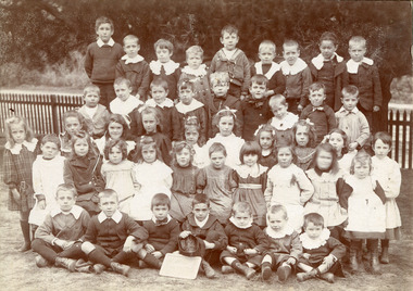
Photograph, Black & White West Beaumaris (Cheltenham) State School Grade 3 1908, 1908
Stephen Charman, 1821-1906 a market gardener, donated land for the first Methodist Chapel, Cemetery and School in Charman Rd Cheltenham 1855. The enrolment was 36 pupils with Mr Frederick Meeres as Teacher. 1863 the school is called Beaumaris Common School No 84 with 70 pupils and Walter Meeres as Teacher. 1869 another 2 acres in Charman Road were granted by the Education Board and brick building built . 1872 State School 84 Beaumaris was increasing enrolments and 1878 a new brick school was built to accommodate 174 pupils and the name changed to Cheltenham State School No.84 1894 Mentone State School No.2950 amalgamated with Cheltenham SS No.84. 1910 the buildings were in disrepair, overcrowding was increasing and renovations were made 1912 with further additions in 1925 and 1937. Post WW11 extra prefabricated Classrooms were added as enrolment increased to 1038 in 1955.. Cheltenham East State School 4754 was opened as housing development spread over the City of Moorabbin . (J.Larson Sandringham HS) 1855 Stephen Charman donated land to the Methodist Church so that a School could be established to educate the children of the early settler market gardeners and farmers in the Cheltenham area . Education was valued by the general community and as well as schools they established mechanics Institutes and Libraries in Moorabbin Shire. Cheltenham State School No. 84 was among the first schools in MelbourneBlack & White photograph of Class 3 pupils at West Beaumaris (Cheltenham )State School 1908Front Handwritten - B.Wooff ---- T.Moodie,- R.Whelan - / 1908 Back Handwritten - Beaumaris, / Mrs White / Mrs Taylorcity of moorabbin, county of bourke, moorabbin roads board, parish of moorabbin, shire of moorabbin, henry dendy's special survey 1841, were j.b., bent thomas, o'shannassy john, king richard, charman stephen, highett william, ormond francis, maynard dennis, cheltenham state school no.84, methodist chapel cheltenham, methodist school cheltenham, beaumaris west state school, meeres frederick, meeres walter, education, early settlers, cancel -
 City of Moorabbin Historical Society (Operating the Box Cottage Museum)
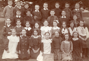
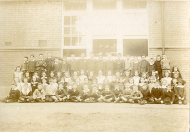
Photograph, Black & White, Cheltenham State School Grade 5 1910, c1910
1855 Stephen Charman donated land to the Methodist Church so that a School could be established to educate the children of the early settler market gardeners and farmers in the Cheltenham area . Education was valued by the general community and as well as schools they established mechanics Institutes and Libraries in Moorabbin Shire. Cheltenham State School No. 84 was among the first schools in Melbourne. Stephen Charman, 1821-1906 a market gardener, donated land for the first Methodist Chapel, Cemetery and School in Charman Rd Cheltenham 1855. The enrolment was 36 pupils with Mr Frederick Meeres as Teacher. 1863 the school is called Beaumaris Common School No 84 with 70 pupils and Walter Meeres as Teacher. 1869 another 2 acres in Charman Road were granted by the Education Board and brick building built . 1872 State School 84 Beaumaris was increasing enrollments and 1878 a new brick school was built to accommodate 174 pupils and the name changed to Cheltenham State School No.84 1894 Mentone State School No.2950 amalgamated with Cheltenham SS No.84. 1910 the buildings were in disrepair, overcrowding was increasing and renovations were made 1912 with further additions in 1925 and 1937. Post WW11 extra prefabricated Classrooms were added as enrollment increased to 1038 in 1955.. Cheltenham East State School 4754 was opened as housing development spread over the City of Moorabbin . (J.Larson Sandringham HS) The names written on the photograph show the pupils belong to many early settler families.1855 Stephen Charman donated land to the Methodist Church so that a School could be established to educate the children of the early settler market gardeners and farmers in the Cheltenham area . Education was valued by the general community and as well as schools they established mechanics Institutes and Libraries in Moorabbin Shire. Cheltenham State School No. 84 was among the first schools in Melbourne. These pupils belong to the early settler families in Moorabbin ShireBlack & White photograph of pupils in Grade 5 at Cheltenham State School No 84 c1910Front ; 1st Rodda - Millege - Lemkie, Orr / 2nd Moorhouse, McGregor, Marriott, N. Bodley, E. Howard / 3rd; K.Whelan,E.Ould, D.Kilburn, Moorhouse, Roberts, - - Tilly - Teagal,Miller, Primer. - Martin, Caulfield Back Mrs Taylorcheltenham primar school, city of moorabbin, county of bourke, moorabbin roads board, parish of moorabbin, shire of moorabbin, henry dendy's special survey 1841, were j.b., bent thomas, o'shannassy john, king richard, charman stephen, highett william, ormond francis, maynard dennis, cheltenham state school no.84, methodist chapel cheltenham, methodist school cheltenham, beaumaris west state school, meeres frederick, meeres walter, education, early settlers, cancel -
 City of Moorabbin Historical Society (Operating the Box Cottage Museum)
Photograph, Black & White, Cheltenham State School Grade 3 5/3/1917, 1917
Ada Pearling Pickering ( G Box ) Stephen Charman, 1821-1906 a market gardener, donated land for the first Methodist Chapel, Cemetery and School in Charman Rd Cheltenham 1855. The enrolment was 36 pupils with Mr Frederick Meeres as Teacher. 1863 the school is called Beaumaris Common School No 84 with 70 pupils and Walter Meeres as Teacher. 1869 another 2 acres in Charman Road were granted by the Education Board and brick building built . 1872 State School 84 Beaumaris was increasing enrollments and 1878 a new brick school was built to accommodate 174 pupils and the name changed to Cheltenham State School No.84 1894 Mentone State School No.2950 amalgamated with Cheltenham SS No.84. 1910 the buildings were in disrepair, overcrowding was increasing and renovations were made 1912 with further additions in 1925 and 1937. Post WW11 extra prefabricated Classrooms were added as enrollment increased to 1038 in 1955.. Cheltenham East State School 4754 was opened as housing development spread over the City of Moorabbin . (J.Larson Sandringham HS) Ada Pearling Pickering was descendant of the George Box Family who migrated in 1850,s and established market gardens in the Brighton area of Dendy's Special Survey 1841 . 1855 Stephen Charman donated land to the Methodist Church so that a School could be established to educate the children of the early settler market gardeners and farmers in the Cheltenham area . Education was valued by the general community and as well as schools they established mechanics Institutes and Libraries in Moorabbin Shire. Cheltenham State School No. 84 was among the first schools in MelbourneBlack & White photograph of pupils at Cheltenham State School No.84 Grade 3 1917 with Ada Pickering a descendant of the Box family early settlershand written Ada Pearling Pickeringbox george, box william, box elizabeth, pickering ada, city of moorabbin, county of bourke, moorabbin roads board, parish of moorabbin, shire of moorabbin, henry dendy's special survey 1841, were j.b.; bent thomas, o'shannassy john, king richard, charman stephen, highett william, ormond francis, maynard dennis, cheltenham state school no.84, methodist chapel cheltenham, methodist school cheltenham, beaumaris west state school, meeres frederick, meeres walter, education, early settlers, -
 City of Moorabbin Historical Society (Operating the Box Cottage Museum)
Photograph, Black & White , Cheltenham State School No. 84 Prep Course A c 1915 Ada Pickering, c1915
Ada Pearling Pickering was a descendant of George Box family who migrated c 1850 and established market gardens in the Brighton area of Dendy's Special Survey 1841. Stephen Charman, 1821-1906 a market gardener, donated land for the first Methodist Chapel, Cemetery and School in Charman Rd Cheltenham 1855. The enrolment was 36 pupils with Mr Frederick Meeres as Teacher. 1863 the school is called Beaumaris Common School No 84 with 70 pupils and Walter Meeres as Teacher. 1869 another 2 acres in Charman Road were granted by the Education Board and brick building built . 1872 State School 84 Beaumaris was increasing enrollments and 1878 a new brick school was built to accommodate 174 pupils and the name changed to Cheltenham State School No.84 1894 Mentone State School No.2950 amalgamated with Cheltenham SS No.84. 1910 the buildings were in disrepair, overcrowding was increasing and renovations were made 1912 with further additions in 1925 and 1937. Post WW11 extra prefabricated Classrooms were added as enrollment increased to 1038 in 1955.. Cheltenham East State School 4754 was opened as housing development spread over the City of Moorabbin . (J.Larson Sandringham HS) 1855 Stephen Charman donated land to the Methodist Church so that a School could be established to educate the children of the early settler market gardeners and farmers in the Cheltenham area . Education was valued by the general community and as well as schools they established mechanics Institutes and Libraries in Moorabbin Shire. Cheltenham State School No. 84 was among the first schools in Melbourne. Ada Pickering was descendant of the early settler Box family who migrated c 1850Black & White Photograph of pupils at Cheltenham State School No 84 c 1915 in Prep Course A with Ada Pickeringback Ada Pearling Pickering box george, box william, box elizabeth, pickering ada, city of moorabbin, county of bourke, moorabbin roads board, parish of moorabbin, shire of moorabbin, henry dendy's special survey 1841, were j.b.; bent thomas, o'shannassy john, king richard, charman stephen, highett william, ormond francis, maynard dennis, cheltenham state school no.84, methodist chapel cheltenham, methodist school cheltenham, beaumaris west state school, meeres frederick, meeres walter, education, early settlers, -
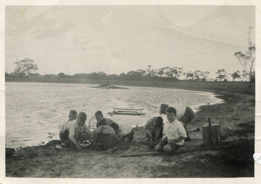 City of Moorabbin Historical Society (Operating the Box Cottage Museum)
Photograph, Black & White, Boys fishing for Yabbies Methodist Childrens' Home Cheltenham 1935, 1935
1892-1953 The Methodist Children's Home in Cheltenham was founded c1880 to provide housing for neglected children from the inner city. The Founders aimed to provide regular nourishment, a stable environment and integrate the children into the local community thereby improving their education and lives. However new settlers to Cheltenham area who were seeking a healthier and more respectable lifestyle for their families were not happy to share Church and School with the Home's Children. 1911 school parents committee moved to exclude the Home's Children but this was countered by the Home's Committee who defeated the motion 60 to 8. 1915 Dr Scantlebury was pressured by school parents into ordering the confinement/ isolation of all Homes Children if an infectious disease was contracted by a child. This resulted in the Homes Children missing school for months so an application was made to the Victorian Education Dept. for e School to be set up at the Home. However funds were short due to WW1. In 1917 John Livingston, former Homes child who had become successful, bequeathed his estate to the Home and the Vic.Education Dept agreed to a school at the Home. The Influenza epidemic 1919 saw the children quarantined for 4 months as a precaution at the Home. When Flu actually struck, a further 5 months isolation was ordered. July 1920 their own school was on site and continuity of education could proceed , however it reinforced the isolation of the institution contrary to the Founders vision of integration.. 1925 the Danks family funded a Domestic Economy Class for girls, but not until 1936 could the children attend the local High School so that they could pursue office work, apprenticeships, commercial college courses. 1947 a benefactor donated £5,000 to pay fees for school, university or apprenticeship in Arts & Cultural subjects. Some of the children were able to join the local society as Methodist minister, accountant, nurses, farmers, secretaries, trademen whilst others were unable to adjust as crime and misfortune ensued. 1939 some past residents began a group called Living Stones Union that they circulated to the others giving news and a sense of family connectedness among themselves. ( Rev. N. Marshall, KCC Local History , H. Stanley 2005) 1950's saw a new direction for the support of children and families in poor and difficult situations . The new Burwood Homes Facility opened in 1951 and children were transferred from Cheltenham in 1952. The land was sold to the St John of God, Catholic Order in1953 who maintained an orphanage until Myer Pty Ltd bought the site in 1967 and constructed the Southland Shopping Centre1892 -1953 The Methodist Children's Home Cheltenham was founded to provide safe accommodation and education for neglected children from the Melbourne inner city slums. Black & White photograph of boys fishing for yabbies from the lake behind the 'Methodist Homes for Children' Cheltenham pdf of Appeal for the establishment of an Infant Asylum 1877methodist childrens home cheltenham 1892- 1953, st john of god home cheltenham 1953-1967, scantlebury dr john city of moorabbin, county of bourke, moorabbin roads board, parish of moorabbin, shire of moorabbin, henry dendy's special survey 1841, were j.b.; bent thomas, o'shannassy john, king richard, charman stephen, highett william, ormond francis, maynard dennis, cheltenham state school no.84, methodist chapel cheltenham, methodist school cheltenham, beaumaris west state school, meeres frederick, meeres walter, education, early settlers, -
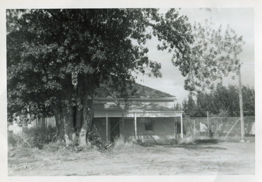 City of Moorabbin Historical Society (Operating the Box Cottage Museum)
Photograph, Black & White Gulliver's House, Marian Lodge, Methodist Childrens Home Cheltemham, c1935
The Methodist Children's Home was originally the home of Mr Gulliver a chemist. It became the centre of a farm at the Home. When the Home was sold to the Catholic Church 1953 it was renamed 'Marian Lodge'. The Methodist Children's Home in Cheltenham was founded c1880 to provide housing for neglected children from the inner city. The Founders aimed to provide regular nourishment, a stable environment and integrate the children into the local community thereby improving their education and lives. However new settlers to Cheltenham area who were seeking a healthier and more respectable lifestyle for their families were not happy to share Church and School with the Home's Children. ( see 00561) 1950's saw a new direction for the support of children and families in poor and difficult situations . The new Methodist Burwood Homes Facility opened in 1951 and children were transferred from Cheltenham in 1952. The land was sold to the St John of God, Catholic Order in1953 who maintained an orphanage until Myer Pty Ltd bought the site in 1967 and constructed the Southland Shopping Centre c1892-1953 The Methodist Children's Home Cheltenham was founded to provide safe accommodation and education for neglected children from the inner city slums. The St John of God Order purchased the Home 1953 and the land was sold to Myer Pty Ltd. who built Southland Shopping Centre 1967 Black & White photograph showing a farm house that was originally owned by Mr Gulliver, a chemist and then the Methodist Children's Home was established 1892. Named Marian Lodge after the St John of God Catholic Order purchased the property in 1953 Back Hand written information st john of god home cheltenham 1953-1967, marian lodge, mr gulliver, pharmacy, methodist childrens home cheltenham 1892-1953, myer southland 1967, city of moorabbin, county of bourke, moorabbin roads board, parish of moorabbin, shire of moorabbin, henry dendy's special survey 1841, were j.b.; bent thomas, o'shannassy john, king richard, charman stephen, highett william, ormond francis, maynard dennis, cheltenham state school no.84, methodist chapel cheltenham, methodist school cheltenham, beaumaris west state school, meeres frederick, meeres walter, education, early settlers, -
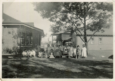 City of Moorabbin Historical Society (Operating the Box Cottage Museum)
Photograph, Black & White Methethodist Childrens Home Cheltenham , Dolls Tea Party 1935, 1935
A typical leisure activity for children of this era was a doll's tea party. The Methodist Children's Home in Cheltenham was founded c1880 to provide housing for neglected children from the inner city. The Founders aimed to provide regular nourishment, a stable environment and integrate the children into the local community thereby improving their education and lives. However new settlers to Cheltenham area who were seeking a healthier and more respectable lifestyle for their families were not happy to share Church and School with the Home's Children. (see 00561) 1950's saw a new direction for the support of children and families in poor and difficult situations . The new Burwood Homes Facility opened in 1951 and children were transferred from Cheltenham in 1952. The land was sold to the St John of God, Catholic Order in1953 who maintained an orphanage until Myer Pty Ltd bought the site in 1967 and constructed the Southland Shopping Centre c1892-1953 The Methodist Children's Home Cheltenham was founded to provide safe accommodation and education for neglected children from the inner city slums. Black & White photograph of Methodist Children's Home and Cottages combined 'Dolls Tea Party' Cheltenham 1935Back Handwritten informationmethodist childrens home cheltenham 1892-1953, dolls, city of moorabbin, county of bourke, moorabbin roads board, parish of moorabbin, shire of moorabbin, henry dendy's special survey 1841, were j.b.; bent thomas, o'shannassy john, king richard, charman stephen, highett william, ormond francis, maynard dennis, cheltenham state school no.84, methodist chapel cheltenham, methodist school cheltenham, beaumaris west state school, meeres frederick, meeres walter, education, early settlers, -
 City of Moorabbin Historical Society (Operating the Box Cottage Museum)
Photograph, Black & White, Methodist Children's Home Cheltenham Boys & Briquettes 1935, 1935
Boys from the Methodist Children's Home Cheltenham collecting Briquettes from the shed. Briquettes, made from Brown coal, were an economical source of heating for the Home The Methodist Children's Home in Cheltenham was founded c1880 to provide housing for neglected children from the inner city. The Founders aimed to provide regular nourishment, a stable environment and integrate the children into the local community thereby improving their education and lives. ( see 00561) 1950's saw a new direction for the support of children and families in poor and difficult situations . The new Burwood Homes Facility opened in 1951 and children were transferred from Cheltenham in 1952. The land was sold to the St John of God, Catholic Order in1953 who maintained an orphanage until Myer Pty Ltd bought the site in 1967 and constructed the Southland Shopping Centrec1892-1953 The Methodist Children's Home Cheltenham was founded to provide safe accommodation and education for neglected children from the inner city slums. Black & White photograph of some boys in the Briquette Shed at Methodist Children's Home Cheltenham 1935Back Handwritten informationmethodist children's home cheltenham 1892-1953, briquettes, heating, yallourn brown coal mine, city of moorabbin, county of bourke, moorabbin roads board, parish of moorabbin, shire of moorabbin, henry dendy's special survey 1841, were j.b.; bent thomas, o'shannassy john, king richard, charman stephen, highett william, ormond francis, maynard dennis, cheltenham state school no.84, methodist chapel cheltenham, methodist school cheltenham, beaumaris west state school, meeres frederick, meeres walter, education, early settlers -
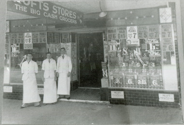 City of Moorabbin Historical Society (Operating the Box Cottage Museum)
Photograph - Black & White, Crofts Grocery 395 Centre Rd Bentleigh c1937, c1937
After the extension of the Railway line from Caulfield to Mordialloc 1880's the shopping centre moved from the Tucker Rd end to around the East Brighton (Bentleigh) Station area of Centre Road. A variety of shops, forges, estate agents, Coles' and Fossey's variety stores, a Hoyts picture theatre, butchers, traded in Centre Rd. Crofts was one many grocery stores along the strip. Crofts Stores was established by Archibald Crofts (1875-1942) as a single grocery store in South Melbourne. It eventually expanded to include 137 branches throughout Victoria, trading as Crofts Stores. The Lees family had established a Seedling Nursery in Thomas St that has continued until the land sold 2018 for housing development.Crofts Grocery Store was one of the shops in the Centre Road Bentleigh shopping strip that were established after the arrival of the train line 1881Black & White photograph of 3 men outside Crofts Grocery Store 395 Centre Rd Bentleigh c 1937 Mr Jack Lees is centre.Handwritten informationcrofts grocery store bentleigh, lees jack, mordialloc railway line, centre road bentleigh, smith j l, smith mary ann, stanley helen, smith vic, smith harry redvers, chaff cutter, horse drawn carts, toll gates brighton, motor cars 1900, steam engines, early settlers, bentleigh, parish of moorabbin, city of moorabbin, county of bourke, moorabbin roads board, shire of moorabbin, henry dendy's special survey 1841, were j.b., bent thomas, o'shannassy john, king richard, charman stephen, highett william, ormond francis, maynard dennis, market gardeners, vineyards -
 City of Moorabbin Historical Society (Operating the Box Cottage Museum)
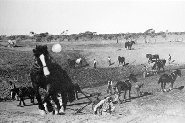
Photograph, Black & White Horse drawn scoops earthwork in Moorabbin Shire c1900, c1900
... , drains, as the settlement of the land, in Dendy's Special Survey ...The, horse drawn metal scoop ,guided by a man, was used to clear earth for road making. Well before the introduction of motorised, mechanical graders and trucks the painstaking, labour-intensive work was undertaken by large teams of sturdy men using strong horses such as the draught horse. Roads were needed by the market gardeners to transport their produce to market. Later as the heavy wagon loads continually caused ruts and general degradation of the roadways a Plateway system was installed so that the wagon wheels could roll along the rails thus protecting the roadways. August 31st 2021 Ron Nash, from WA, informs us "The men and horses pulling earth scoops in the photo are not moving earth for road making - they are excavating an "earth tank", or dam, as described in common nomenclature today. This skill was known as "tank sinking", and tank sinkers were active in many rural and remote areas in the 1800's and early 1900's, establishing sizeable dams for important water reserves for community and farm and railway use. With the advent of mechanised equipment such as bulldozers, the trade of tank sinking was still carried out, but on a faster basis. I am a former tank sinker and earth moving contractor, now long retired." Early settlers in Moorabbin Shire had to build the roads, plateways, drains, as the settlement of the land, in Dendy's Special Survey 1841 Brighton, spread and market gardeners need to transport their produce to market. Their most valuable possession was the draught horse that was used for ploughing, drawing carts and these scoops.Black & White photograph showing many horses pulling metal scoops guided by men to move earth for road making in Moorabbin Shire c 1900Back Handwritten Informationplateway, roadworks moorabbin shire, draught horses, metal scoops, paviers, box alonzo, smith j l; chaff cutter, horse drawn carts, toll gates brighton, motor cars 1900, steam engines, early settlers, bentleigh, mckinnon, parish of moorabbin, city of moorabbin, county of bourke, moorabbin roads board, shire of moorabbin, henry dendy's special survey 1841, were j.b.; bent thomas, o'shannassy john, king richard, charman stephen, highett william, ormond francis, maynard dennis, market gardeners, vineyards, orchards -
 City of Moorabbin Historical Society (Operating the Box Cottage Museum)
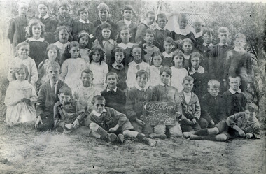
Photograph, Black & White, x2 Cheltenham State School No.84 Charman Rd c 1910, c1910-20
Stephen Charman, 1821-1906 a market gardener, donated land for the first Methodist Chapel, Cemetery and School in Charman Rd Cheltenham 1855. The enrollment was 36 pupils with Mr Frederick Meeres as Teacher. 1863 the school is called Beaumaris Common School No 84 with 70 pupils and Walter Meeres as Teacher. 1869 another 2 acres in Charman Road were granted by the Education Board and brick building built . 1872 State School 84 Beaumaris was increasing enrollments and 1878 a new brick school was built to accommodate 174 pupils and the name changed to Cheltenham State School No.84 1894 Mentone State School No.2950 amalgamated with Cheltenham SS No.84. 1910 the buildings were in disrepair, overcrowding was increasing and renovations were made 1912 with further additions in 1925 and 1937. Post WW11 extra prefabricated Classrooms were added as enrollment increased to 1038 in 1955.. Cheltenham East State School 4754 was opened as housing development spread over the City of Moorabbin . (J.Larson Sandringham HS) The boys wearing round collars are from the Methodist Children's Home Cheltenham 1892-1953 that was situated on land now Southland Shopping Centre 1855 Stephen Charman donated land to the Methodist Church so that a School could be established to educate the children of the early settler market gardeners and farmers in the Cheltenham area . Education was valued by the general community and as well as schools they established mechanics Institutes and Libraries in Moorabbin Shire. Cheltenham State School No. 84 was among the first schools in Melbourne2x Black & White photographs of pupils at Cheltenham State School Charman Rd. c 1910-1920 a) Cheltenham State School No 84 c 1910 b) Cheltenham State School No.84 c 1910-1920 Grade 6a) Handwritten Cheltenham ( Charman Rd ) School / probably about 1910 b) " Charman Road School / taken probably between 1910 & 1920cheltenham primary school, methodist children's home cheltenham 1892-1953, city of moorabbin, county of bourke, moorabbin roads board, parish of moorabbin, shire of moorabbin, henry dendy's special survey 1841, were j.b., bent thomas, o'shannassy john, king richard, charman stephen, highett william, ormond francis, maynard dennis, cheltenham state school no.84, methodist chapel cheltenham, methodist school cheltenham, beaumaris west state school, meeres frederick, meeres walter, education, early settlers, cancel -
 City of Moorabbin Historical Society (Operating the Box Cottage Museum)
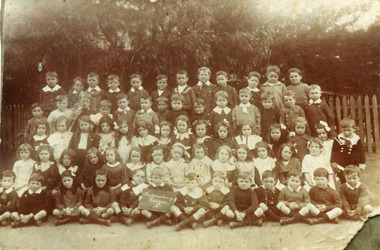
Photograph, Black & White x 2 Cheltenham State School 1913, 1913
Stephen Charman, 1821-1906 a market gardener, donated land for the first Methodist Chapel, Cemetery and School in Charman Rd Cheltenham 1855. The enrolment was 36 pupils with Mr Frederick Meeres as Teacher. 1863 the school is called Beaumaris Common School No 84 with 70 pupils and Walter Meeres as Teacher. 1869 another 2 acres in Charman Road were granted by the Education Board and brick building built . 1872 State School 84 Beaumaris was increasing enrollments and 1878 a new brick school was built to accommodate 174 pupils and the name changed to Cheltenham State School No.84 1894 Mentone State School No.2950 amalgamated with Cheltenham SS No.84. 1910 the buildings were in disrepair, overcrowding was increasing and renovations were made 1912 with further additions in 1925 and 1937. Post WW11 extra prefabricated Classrooms were added as enrollment increased to 1038 in 1955.. Cheltenham East State School 4754 was opened as housing development spread over the City of Moorabbin . (J.Larson Sandringham HS) The boys wearing round collars are from the Methodist Children's Home Cheltenham1855 Stephen Charman donated land to the Methodist Church so that a School could be established to educate the children of the early settler market gardeners and farmers in the Cheltenham area . Education was valued by the general community and as well as schools they established mechanics Institutes and Libraries in Moorabbin Shire. Cheltenham State School No. 84 was among the first schools in Melbourne.Faded, Black & White photograph x 2 of pupils at Cheltenham State School No. 84 1913 1st Group & 2nd GroupFront 1913city of moorabbin, county of bourke, moorabbin roads board, parish of moorabbin, shire of moorabbin, henry dendy's special survey 1841, were j.b., bent thomas, o'shannassy john, king richard, charman stephen, highett william, ormond francis, maynard dennis, cheltenham state school no.84, methodist chapel cheltenham, methodist school cheltenham, methodist children's home cheltenham 1892-1953, beaumaris west state school, meeres frederick, meeres walter, education, early settlers, cancel -
 City of Moorabbin Historical Society (Operating the Box Cottage Museum)
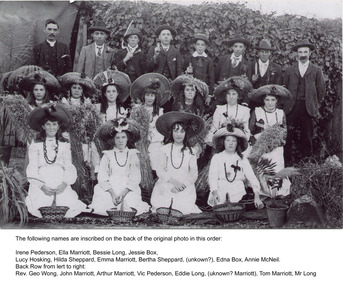
Photograph, Black & White,Methodist Youth 'Harvest Festival' East Bentleigh c1910, original c1910
Early settlers established market gardens, farms and business in the East Brighton ( East Bentleigh) area of Henry Dendy's Special Survey 1841 Brighton. The small communities established Churches and Schools. Stephen Charman, 1821-1906 a market gardener, donated land for the first Methodist Chapel, Cemetery and School in Charman Rd Cheltenham 1855. The East Bentleigh settlers built a Methodist Church in Tucker Road and established the Sunday School and Youth group which organised social and sporting events and picnics.Early settlers established market gardens, farms and business in the East Brighton ( East Bentleigh) area of Henry Dendy's Special Survey 1841 Brighton. The small communities established Churches and Schools. Black and White photograph showing the Bentleigh Methodist Youth Group on Harvest Thanksgiving Sunday c1910 in front of R.Smith's shed in Tucker Road East Bentleigh re-digitised by H.Stanley CMHS 2005Back Handwritten Names on Original photograph Front row Irene Pederson, Ella Marriott, Bessie Long, Jessie Box, Lucy Hosking, Middle row Hilda Sheppard, Emma Marriott, Bertha Sheppard, ? , Edna Box, Annie McNeil Back row Rev. George Wong, John Marriott, Arthur Marriott, Vic Pederson, Eddie Long, ? Marriott,, Tom Marriott, Mr Long methodist youth group bentleigh c1910, marriott emma, marriott ella, hosking lucy, marriott john, box jessie, pederson vic, long bessie, wong george, shephard hilda, mcneil annie, smith j l; smith mary ann, stanley helen, smith vic, smith harry redvers, chaff cutter, horse drawn carts, toll gates brighton, motor cars 1900, steam engines, early settlers, bentleigh, mckinnon, parish of moorabbin, city of moorabbin, county of bourke, moorabbin roads board, shire of moorabbin, henry dendy's special survey 1841, were j.b.; bent thomas, o'shannassy john, king richard, charman stephen, highett william, ormond francis, maynard dennis, market gardeners, vineyards, orchards -
 City of Moorabbin Historical Society (Operating the Box Cottage Museum)
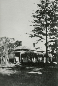
Photographs x 3 B/W Box Cottage Front House with Pine Trees at Ormond, Frieda in garden c 1921, c1921
In 1855 William and Elizabeth Box migrated from Sussex England to Melbourne and in 1868, 1869 purchased 2 x 10acre Lots in part of Henry Dendy's Special Survey Brighton 1841. A Cottage was already on the land and they established a flower garden and raised 13 children. In 1888 William sold one Lot and built a new Front House . William died 1902 and Elizabeth sold the land except 1 acre and retained both the Cottage and the Front House. After her death in 1914, her daughters Violet and Ada leased the Cottage and Front House to tenants until August Rietmann purchased the property in 1935. August Rietmann (1877-1951) of Lustdorf ,Switzerland, married Maria Frieda Oesschlager (2/2/1878- 22/7/1942) of Baden Baden, Germany on 6/8/1910. In August 8th 1915 August and his wife Frieda migrated to Melbourne, Victoria, Australia sailing on the Steam Ship ‘Osterley’ from Marseilles to Melbourne They leased Box Cottage, Ormond in 1917 and raised two children, Stefanie (1918 -2006) and William (1920- 1997). 1935 August purchased the property and the family used the Cottage during the day and slept in the Front House. August was a monumental mason, potter and sculptor, and was employed at Corbens Ltd Clifton Hill, to carve war memorials in Victoria post WW1 c 1915-1922. During the 1920's August set up his own business in pressed cement making pot plants, columns,paving slabs and lampstands. He continued to carve headstones and figures and took contract work for Artists eg Paul Mountford. He built a workshop in the Barn and used the Cottage for plaster moulding. His son William joined the business and and the family continued to use the site after August died in 1951. Rietmann Landscaping Ltd moved to Bay Road Highett in 1953 and later to Carrum. The land, containing the Box Cottage, was sold to Lewis Timber Pty Ltd in 1970 and Mr Lewis proposed that Moorabbin City Council should preserve the heritage Cottage. In 1984 the Cottage was dismantled and reconstructed in the adjacent Joyce Park. The Rietman family is an example of the diverse nationalities that lived and worked productively in Moorabbin Shire 1871–1933 , the City of Moorabbin 1934-1994 and continues today in the Cities of Glen Eira, Kingston, Bayside, and Monash. August, a sculptor and stone mason, was employed by Corben Pty Ltd Clifton Hill to carve WW1 Memorials before establishing his own successful masonry business in the Box Cottage during the latter 1920s. After becoming interested in pressed cement casting, he took on apprentices (1930s Depression) and among his products were garden furniture, pots and also street lamp standards, some of which were installed in St Kilda Road. After August’s death in 1951, his family continued the business ‘Rietman’s Landscaping Ltd.’, at Highett and Carrum.Photographs x 3 Black & White of the Front House with Pine Trees at Ormond and Frieda Rietmann in garden c1921 Photograph x 1 Colour Digital by Glen Lewis of these Pine Trees in situ Lewis Timber Pty Ltd Ormond 2020Handwritten a) path to Front House c 1921; b) Pine trees and Front House c) Frieda in garden c1921box william, box elizabeth, box cottage museum ormond, dendy henry, dendy's special survey brighton 1841, market gardeners, seedling nurseries, rietmann august, rietman august, rietmann frieda, rietman frieda, stonnington city town hall, war memorials, world war 1 1914-1918, rietman stefanie, rennick stefanie, francis stefanie, rietman william, rietman ray, mountford paul, malvern city town hall, joyce park ormond, rietman's landscaping pty ltd, bay road highett, macrobertson pty ltd, coleraine soldier memorial 1921 -
 City of Moorabbin Historical Society (Operating the Box Cottage Museum)
Photographs, 7 x B&W Circa 1918 Cheltenham Methodist Youth Group, Circa 1918 Photos of Cheltenham Methodist Youth Group, 1918
Circa 1918: Various Photos of the Cheltenham Methodist Youth Group. Row 1 and 2: "At Flinders". Row 3: 1st Left, "Holidaying at Cockatoo". in 1852 Stephen Charman, who had arrived in Melbourne 1842 aged 21 years as one of Henry Dendy's emigrants, purchased 160 acres in Spring Grove ( now Cheltenham). Stephen and his family lived in a wattle and daub hut and worked hard to establish a market garden, poultry and pig farm. The first Methodist Church Services were held at their home. In 1855 Stephen gave 1 acre of his land on Balcombe Road to the Methodist Church for a School, Burial ground and a Chapel which was built in 1857.The Methodist Church, Balcombe Road was the 2nd religious building to be erected in Spring Grove now known as Cheltenham c 18577 small black and white photographs of the Cheltenham Methodist Youth Group at Flinders, Cockatoo and unkown locations, c 1918 . First 3 photos are of male cyclists on a trip to Flinders, Victoria. Photo 4 shows 6 ladies and a man on holiday at Cockatoo in the Dandenong Ranges ,Victoria . Photos 5 to 7 show men, women and children in bushland surroundings of unrecorded locations.Photo 1 - 3 on back : Flinders 1918 Photo 4 left on back : Holiday at Cockatoo right on back : Whitehead Photo 5-7 nilcheltenham, cheltenham methodist youth group, 1914, 1918, charman stephen, gettens mary, spring grove, methodist church, charman road, balcombe road, dendy henry, henry dendy's special survey 1841, youth groups, social groups, market gardners, early settlers, pioneers, dairy farmers, poultry farmers, pig farmers,moorabbin, brighton, -
 City of Moorabbin Historical Society (Operating the Box Cottage Museum)
Photograph - Photograph, Mrs Carroll c1910, Mrs Carroll c1910, possibly c1910
Date unknown: Mrs Caroll and children. In 'Moorabbin A Pictorial History 1862 - 1994 ' by John Cribbin, The Carroll family migrated from Ireland and purchased land in the East Brighton ( now Bentleigh ) area of Henry Dendy's Special Survey 1841. Edward, J.W. & Daniel are shown in the Rate Book 1862 as owner occupiers and owner of property in Tuckers Road, Bryants Road and Centre Road.Photograph is black and white. There are three women in this photograph, a mother and her two children. The mother is sitting down on a chair to the left and her daughter sitting next to her, on the right (they are both holding hands), and her other daughter (child) right in between her mother and sister, with he arm around the mother's shoulder. All three of them are wearing their best dresses that have lace collars. As the clothes are similar to MAV Cat No. 00519 the photo may have been taken c 1910Front of Mount : Yeoman Co 287 Chapel St. Prahran, Victoria.children, chapel st, 287, prahran, carroll edward, carroll, j.w., carroll daniel, ireland, brighton, henry dendy's special survey 1841, market gardeners, pioneers, early settlers, dairy farmers, poultry farmers, bentleigh, mckinnon, ormond, prahran, yeoman photographers co. -
 City of Moorabbin Historical Society (Operating the Box Cottage Museum)
Newsletter, City of Moorabbin Historical Society Apr 2009, April 2009
The City of Moorabbin Historical Society was formed c 1960 by a group of Moorabbin residents who were concerned that the history of the area should be preserved. A good response to a call for items related to the historical area of Moorabbin Shire brought donations of a wide variety of artefacts which are now preserved by the current members of CMHS at Box Cottage Museum . Helen Stanley, Secretary of CMHS, began producing a Newsletter for members in April 2007 to provide current information and well researched items of historical interest.Helen Stanley has produced a bi-monthly Newsletter, 2007 - 2013, for the members of the City of Moorabbin Historical Society that contains well researched interesting historical items, notification of upcoming events, current advice from Royal Australian Historical Society , Museums Australia Victoria and activities of Local Historical Societies. The Newsletter is an important record of the activities of the CMHS.2 x A4 paper printed on 4 sides Issue 11 of the bi-monthly, City of Moorabbin Historical Society Newsletter produced by Society member and Secretary, Mrs Helen Stanley in April 2009. Notice that Mr Travis Sellars, Friends of Cheltenham and Regional Cemeteries, will talk about ‘The Tragic 20’s’ at the meeting April 26th . Volunteers are needed to show visitors around on Open Days each month and a Roster will be made on April 26th . Suggestions are requested for the Community Grant Application to be submitted by CMHS. Historical details are condensed from ‘ The Living Harvest’ by W.T Dobson, describing the establishment of St. Peter’s Catholic School East Bentleigh 1865 on land donated by Fred Quinn , in Centre Road, East Brighton ( East Bentleigh). A photo copy of Parts of Country Portion 39 of Dendy’s Special Survey or Brighton Estate showing the Land Sales of Lot 2, & 3 North Road and Jasper Road 1841 – 1869. Interesting note on the origin of ‘Jasper Road’. 3 photocopied photographs of St Peter’s School building 1903, School Children at East Brighton Railway Station, 1903, A Lorry in the parade 1903. CITY of MOORABBIN HISTORICAL SOCIETY / APRIL 2009 NEWSLETTERcity of moorabbin historical society, stanley helen, dobson w.t., melbourne, moorabbin, brighton, friends of cheltenham and reional cemeteries, cheltenham, ormond, bentleigh, market gardeners, irish immigrants c1850pioneers, early settlers, moorabbin shire, box cottage museum, port phillip bay, brighton estate, jasper road ormond, east boundary road brighton, dendy’s special survey 1851, point nepean road, south road brighton, thomas street brighton, north road brighton, county of bourke, box h., box william, parish of moorabbin, parish of prahran, markets, shingle roof, weather-board, mr., mckinnon, were jonathan, niall rev. fr. patrick, quinn fred, elsternwick, catholic church directory 1878, hibernian society melbourne, brady peter., kennedy mr., boland mr., leary mr., gahan mr., archbishop carr, rev. fr. gough., presentation convent gardenvale, sister mary vincent, charlston john, bavarian dress band, hales jasper -
 City of Moorabbin Historical Society (Operating the Box Cottage Museum)
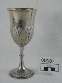
Award - Trophy, c.1880
... activities. After the 1841 Dendy Special Survey allotments of land ...Robert Keys,1818-87 b.Ireland, arrived Australia 1841 and joined parents on a farm in Brighton.Victoria. 1870 he commenced his own 15 acre 'fruit garden' in Keys Rd Moorabbin and in 1881-82 was awarded the 'Leader Cup', by the Leader Newspaper, as the Winner of the Brighton Horticultural Society 'Best Fruit Garden' competition. Robert Keys, early settler 1841, was a talented orchardist , Brighton Councillor 1860 and Moorabbin City Coucillor until his death 1887. Item donated by Keys Family c1985 The 1879 Schedule of Prizes booklet of the Brighton Historical Society ( MAV 00022),describes in detail this trophy, prize moneys and rules and regulations of the competition. The booklet, cat. no. 00022, is on display with this trophyThis item is significant because of its connection with the Keys Family who were early settlers in District of Brighton/ Moorabbin and were greatly involved in community activities. After the 1841 Dendy Special Survey allotments of land were sold or rented to pioneer settlers who developed market gardens, fruit farms ( orchards), vineyards, poultry farms in the area now known as Bentleigh, Cheltenham, Oakleigh. They were very proud of their fine produce and hence enthusiastically entered these 'Annual Exhibitions' by the Brighton Horticultural Society.The Sterling Silver goblet shaped Trophy. Base has engraved beaded rim with chevron type motif. Embossed ring midway up stem and fern leaves engraved on bowl of goblet engraved on bowl of goblet " Brighton Horticultural Society/ 1881-82/ Leader Cup/ Awarded To/ Robert Keys/ For Best Fruit Garden/ Brighton District." Hallmarked 'GU', Birmingham, UK. George Unite circa 1880keys robert, trophy, 1881, leader newspaper, leader cup, brighton, horticultural, silver cup, silver, moorabbin, brighton horticultural society -
 City of Moorabbin Historical Society (Operating the Box Cottage Museum)
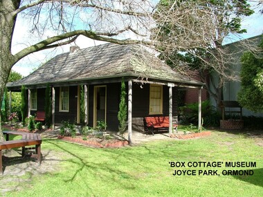
Photograph - ' Box Cottage' Reconstruction, c1841
The original small, pioneer cottage was built in the late 1840s to early1850s, by an unknown pioneer. It was located on part of a 30 Acre allotment that was originally part of Henry Dendy’s Special Survey granted in 1841. The doors and window sashes, (made of red deal joinery timber), as well as the brass locks and fittings, are from the original cottage, and were imported from England.The fire-place bricks are from the original cottage, and are sun-dried, (not kiln fired), and are hand-made. Convict marks can be seen on two bricks.There is a small display of external cladding shingles from the original pioneer cottage. These shingles were hand-split, and most likely made from locally collected timber The nails included in this display were used to fasten the shingles on the original cottage, and are also hand-made. The enamel nameplate, “Colonial”, on the wall of the cottage, was the name chosen for the original pioneer cottage when a later owner, Mr August Rietman and wife Frieda leased the property in around 1917. August purchased the property 1935 for 1200 Pounds approximately and resided there until 1953. In 1974 Mr Lewis, a timber specialist, found the dilapidated building on property he had recently purchased in Jasper Rd and suggested it be reconstructed and relocated. Moorabbin Council agreed and the Cottage was rebuilt just about 250 metres from its original site. The cost of the rebuild was met by 'Victoria's 150th Committee, plus a small grant from the City of Moorabbin, and Mr Laurie Lewis donated much of the timber for the reconstruction. Although 'Box Cottage' is a re-construction, it is an unique museum that, being located in the midst of a modern community in Ormond Victoria, can educate and demonstrate many aspects of the early settler’s way of life in Victoria. As such, it is an invaluable resource for students and all kinds of visitors. The original small, pioneer cottage was built in the late 1840s to1850s, by an unknown pioneer. It was located on part of a 30 Acre allotment that was originally part of Dendy’s Special Survey granted in 1841. The re-constructed pioneer cottage, named ‘Box Cottage’, is located only a matter of metres from the original pioneer cottage site, in Joyce Park, Jasper Road, Ormond, Victoria. The museum has copies of interesting Land Titles associated with the surrounding land, including the site of the original pioneer cottage, from Dendy’s time, and into the 1900s. ‘Box Cottage’ is named after the pioneers, William and Elizabeth Box, who resided in the original cottage from approximately 1865, until Elizabeth’s death in 1914.The re-constructed cottage plan has followed faithfully the original dimensions, and plan of the original pioneer cottage, and as many original items from that cottage’s long occupation have been incorporated. Convict marks on sun -dried, fire-place chimney bricks. Enamel nameplate 'Colonial' circa1915brighton, moorabbin, cottages, pioneers, ormond, colonial, mckinnon, dendy henry, box william, box elizabeth, convicts, rietman august, rietman frieda, rietman stefanie