Showing 1497 items
matching land use
-
 Warrnambool and District Historical Society Inc.
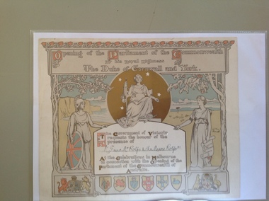
Certificate - Invitation to the opening of the Parliament of the Commonwealth of Australia, 1900
This certificate is an invitation to the opening of the first Parliament of Australia on January 1st 1901 in Melbourne. On this date the six Australian self-governing colonies were federated to become the six states of Australia. The designers of the certificate were Norman Lindsay and John Longstaff. This particular invitation was sent to George Rolfe and his wife and two of his stepdaughters, Annie and Florence. George Rolfe (1836-1919), a tea merchant from Melbourne, began buying blocks of land near the mouth of the Hopkins River in Warrnambool in the 1870s. By the early 1880s Rolfe owned 50 acres in the town, including farming properties and used the buildings near the mouth of the Hopkins as holiday accommodation. He called his property Lyndoch which he improved with the addition of stables, chaff and bone sheds, jetty, boathouse, reservoir, water well and windmill and extensive gardens and he spent most of his later life in this Warrnambool area. Lyndoch today is the site of an aged care facility. This certificate is of considerable importance for two reasons: 1. It is an important memento of a signal event in Australia’s history - the Federation of the States in 1901. 2. The certificate was an invitation to the family of a prominent Warrnambool person – George Rolfe of Lyndoch.This is a piece of thick paper with illustrations and decorations in brown, red, blue, yellow and green tonings. The lettering is in white with coloured capital letters. The images include the shields of the six Australian States, the Coat of Arms of Britain and Australia, outlines of two trees (gum tree and oak tree) and three symbolic female figures representing Justice, Britannia and Australia. The top border decoration represents the waratah flower. The names of the invitees on this certificate have been handwritten in black ink. ‘Opening of the Parliament of the Commonwealth by His Royal Highness The Duke of Cornwall and York’ ‘Mr G and Mrs Rolfe and the Misses Rolfe (2)’ george rolfe of lyndoch, federation of australia, history of warrnambool, george rolfe, opening of first parliament of australia -
 Warrnambool and District Historical Society Inc.
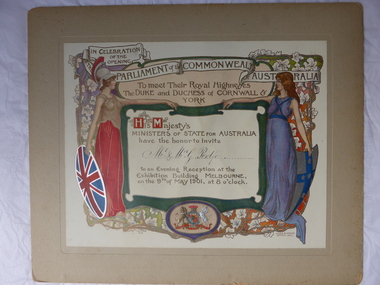
Certificate, Duke of Cornwall
This certificate is an invitation to the Evening Reception in Melbourne in 1901, an event which was part of the celebrations in Melbourne to commemorate the Federation of the six colonies into the six States of Australia in January 1901. The certificate was sent to the invitees after the event as a souvenir of the occasion. The certificate was designed by the artists Julian and Howard Ashton and lithographed and issued by Sands and McDougall Limited of Melbourne. This particular certificate was sent to George Rolfe and his wife Annie. George Rolfe (1836-1919), a tea merchant from Melbourne, began buying blocks of land near the mouth of the Hopkins River in the 1870s. By the early 1880s he had acquired 50 acres of land in the town and several nearby farming properties. He used the buildings on the land at the mouth of the River Hopkins as holiday accommodation and called this property Lyndoch. Rolfe improved this property adding stables, jetty, boathouse, bone and chaff sheds, reservoir and windmill and extensive gardens. Rolfe spent most of his later life at Lyndoch. Today the property is the site of an Aged Care Facility. This certificate is of considerable importance for two reasons: 1. It is an attractive and valuable memento of a signal event in Australia’s history – the Federation of the States in 1901. 2. The certificate was an invitation to Mr and Mrs George Rolfe. Rolfe was a prominent person in Warrnambool in the late 19th and early 20th centuries. This is a multi-coloured certificate mounted on a piece of grey cardboard. The certificate is highly embossed and has a figure of Britannia in a red dress and a mailed vest holding a shield with the Union Jack emblem. Britannia is extending her hand to a figure of a younger woman representing Australia. This figure is dressed in blue and holds a shield which has a blue cross with white stars. The borders have vines and vine leaves and the Royal Crest is at the base of the certificate. The names of the invitees are handwritten in black ink. ‘In Celebration of the Opening of the Parliament of the Commonwealth of Australia, To Meet Their Royal Highnesses, the Duke and Duchess of Cornwall and York, His Majesty’s Ministers of State for Australia have the honor to invite Mr & Mrs G. Rolfe to an Evening Reception at the Exhibition Building, Melbourne on the 9th of May 1901, at 8 0’clock’. george rolfe of lyndoch, warrnambool, federation of australia, history of warrnambool, george rolfe -
 Warrnambool and District Historical Society Inc.
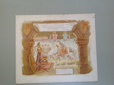
Certificate - Open Commonwealth Parliament, 1901
This is an invitation to George and Annie Rolfe of Lyndoch, Warrnambool, to attend the opening of the first Australian Parliament in Melbourne in May 1901. A smaller invitation card was first sent to the recipients and this larger invitation was sent after the event for the recipients to keep as a souvenir. The six Australian colonies became six Australian States in the newly-formed Commonwealth of Australia in January 1901. George Rolfe (1836-1919), a tea merchant from Melbourne, began buying blocks of land in Warrnambool near the mouth of the Hopkins River in the 1870s. By the early 1880s Rolfe owned 50 acres of land in the town and other nearby pastoral properties. He used the existing building on the land near the mouth of the Hopkins River as holiday accommodation, calling the property Lyndoch and adding stables, bone and chaff sheds, jetty, boathouse, reservoir and windmill and an extensive garden. George Rolfe spent most of his later life at Lyndoch. Today the area is the site of an aged care facility. This certificate is of considerable importance for two reasons: 1. It is an important memento of a signal event in Australia’s history – the Federation of the States in 1901. 2. The certificate was an invitation to George Rolfe of Lyndoch and his wife. Rolfe was a prominent Warrnambool person at that time. This is a piece of cardboard containing an illustration of a young queen in battle dress and on horseback bowing to an image of Britannia. The queen is about to be crowned. There are several lady attendants in the background and two large columns depicted on the sides of the illustration with shields and banners. An extract from Kipling’s poem, The Young Queen, is printed at the bottom of the card. The invitation is coloured in brown, yellow, white and orange tonings. The name of the recipient of the card is handwritten in black ink. The card is slightly scuffed and marked. The card is an invitation to Mr and Mrs Rolfe to attend the Opening of the First Australian Parliament in Melbourne in May 1901. ‘Mr & Mrs G. Rolfe’ federation in australia, george rolfe and family, history of warrnambool, lyndoch warrnambool -
 Warrnambool and District Historical Society Inc.
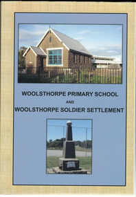
Book, Woolsthorpe Primary School and Woolsthorpe Soldier Settlement
History of the Woolsthorpe Primary School and Woolsthorpe Soldier SettlementThis is a soft-cover book with a blue and buff- coloured front cover featuring photographs of the Woolsthorpe Primary School and the Woolsthorpe War Memorial. The back cover has photographs of the R.S.L. Badge and the Woolsthorpe Primary School. It has 160 pages. non-fictionHistory of the Woolsthorpe Primary School and Woolsthorpe Soldier Settlementwarrnambool, woolsthorpe, soldier settlement -
 Warrnambool and District Historical Society Inc.
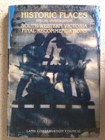
Book, Historic Places of South West Victoria
This is the third in a series of booklets produced by the Land Conservation Council in 1997 (176 pages). Booklets One and Two (1996) contained A Descriptive Report and Proposed Recommendations. The Final Recommendations include information on processes for protection of historic places, lists of significant places in the south-western region and aboriginal historic places. Attached inside the back cover are two maps showing the location of the significant places.This is a useful book as it lists the declared historic sites in the region and researchers will find the information helpful. This is a soft-cover book with a multi-coloured cover featuring a photograph of the Pioneers Memorial, Deep Lead. It has a red-coloured spine and back cover.Front Cover – Historic Places - Special Investigation - South-Western Victoria - Final Recommendations – Land Conservation Council Spine – Historic Places – South-Western Victoria – Final Recommendations – Land Conservation Council Back Cover – Historic Places, Final Rec., code used for retail sales warrnambool -
 Warrnambool and District Historical Society Inc.
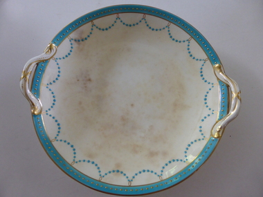
Plate, Rolfe dinner plates x 4, 1864
These dishes were part of a crockery set used in the George Rolfe household at Lyndoch, Warrnambool. George Rolfe (1836-1919) was a Melbourne tea merchant who acquired land at the mouth of the Hopkins River in Warrnambool from the 1880s on as a holiday home. He developed the property over the years, adding a windmill and reservoir, bone and chaff sheds, a stable, jetty and boathouse and an extensive garden. In 1891 he married Mrs Annie Lake and it was his stepdaughter, Florence Lake who built the house, Lyndoch in the 1920s. This building today forms part of an Aged Care Facility. This item is part of the larger Rolfe dinner set as described on Victorian Collections at VC001421 and VC001422These dishes are of importance as they belonged to the George Rolfe family of Lyndoch, Warrnambool. They demonstrate the quality of the household goods used by more affluent families in the second half of the 19th century. These are four china serving dishes or plates which are part of a set of crockery used in the Rolfe Lyndoch household in Warrnambool. The dishes have a circular base with a circular dish resting on the base. The dishes have or had two handles with these handles and the edges of the dishes being gold trimmed. Around the rim of the dishes is a pattern of loops and dots etc of teal and gold. One dish (.1) has no handles, one dish (.4) has one handle only and two dishes are cracked (.3 & .4) . Two dishes are stained, one severely (.2 & .4) ‘Minton’ george rolfe, florence lake -
 Warrnambool and District Historical Society Inc.
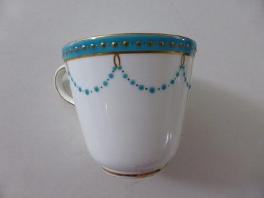
China, Cups x 4, 1864
These dishes were part of a crockery set used in the George Rolfe household at Lyndoch, Warrnambool. George Rolfe (1836-1919) was a Melbourne tea merchant who acquired land at the mouth of the Hopkins River in Warrnambool from the 1880s on as a holiday home. He developed the property over the years, adding a windmill and reservoir, bone and chaff sheds, a stable, jetty and boathouse and an extensive garden. In 1891 he married Mrs Annie Lake and it was his stepdaughter, Florence Lake who built the house, Lyndoch in the 1920s. This building today forms part of an Aged Care Facility. This item is part of the larger Rolfe dinner set as described on Victorian Collections at VC001421 and VC001422These cups are part of a crockery set, and are kept because they belonged to George Rolfe, a prominent property owner and farmer in Warrnambool in the late 19th century and early 20th century. The items, dating from 1864, have social significance showing the type of crockery used by a more affluent family in the 19th century.Four small white cups decorated with aqua band around the top of each cup . A scalloped pattern of dots are suspended from the solid band which is decorated with a row of gold dots. There is a gold rim at the base of the cup.Mintonrolfe, lyndoch, warrnambool, minton cups, mrs annie lake -
 Warrnambool and District Historical Society Inc.
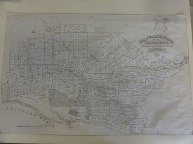
Map, Warrnambool 1859, Late 20th century (copy)
This is a copy of Bromfield’s 1856 map of Warrnambool and district. James Astley Bromfield was a pioneer settler in Warrnambool. He established a chemist’s shop in 1854, initially situated in Timor Street. He moved his shop to Liebig Street with a new building erected in 1875. Bromfield was a prominent resident of Warrnambool (Shire Councillor, Fire Brigade member, Cricket Club member, associated with horse racing etc). He was interested in preserving the history of Warrnambool and this map he produced in 1856 was an example of this interest.This is a copy only but this 1856 map is of prime importance as it contains the names of the original landowners of land in north Warrnambool and the surrounding district. It is a frequently-used resource by historians.This is a copy of a map of Warrnambool and its agricultural district published by James Astley Bromfield in 1856. The map is mounted on cardboard and has black printing on a white background. ‘Map of Warrnambool and its Agricultural District according to the Government Survey’s published by Astley Bromfield, Medical Hall, Warrnambool 1856, James Ferguson, Lithr., Melbne.’bromfield’s 1856, map, warrnambool and district -
 Warrnambool and District Historical Society Inc.
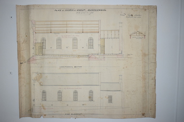
Document, Plan of Church of Christ Warrnambool, 1883
These plans have been drawn up in 1883 by the Warrnambool architect, William Patterson. They show six sections of plans for the erection of a Church of Christ at 12 Spence Street Warrnambool. The mason was William Kellas and the builder was Harold Dawkins. Church of Christ adherents began meeting in Warrnambool in 1875 and bought land in Spence Street in 1877. The church was opened in 1885 with visiting pastors until a resident minister, A. J. Fisher, was appointed in 1915. This church was closed early in the 21st century when a new church, Gateway Church of Christ, was opened in Ragland Parade in Warrnambool. These plans are of great interest as original ones of the Church of Christ In Spence Street Warrnambool. The plans have come from the present-day Warrnambool Church of Christ. The building still exists but is no longer is use as a church. These are two sheets of cream-coloured thick paper with scaled drawings of plan sections of the Church of Christ in Warrnambool. The drawings are in black ink with some sections coloured in. Both pages have a black line margin drawn around the edges. The pages are torn at the edges in several places and the sheets are much stained. The sheets have been reinforced at the back (left side) with thick brown paper.‘Plan of Christ Church Warrnambool’plans church of christ warrnambool, william kellas, harold dawkins warrnambool -
 Kiewa Valley Historical Society
Newspaper Article - Thomas Briggs, 5th March 1988
Thomas Briggs was a pioneer of the Tawonga District. He worked on his parent's farm, selling goods, droving pigs and travelling to Yackandandah and Bright. He worked with pick and shovel on the Tawonga to Bright Road in 1902. He took up 320 acres of wild forest in Tawonga at 10 cents per acre per year for 20 years. He built a slab and shingle hut and a boundary fence. In 1886 he married Annie Maria Platt parenting 5 sons and 2 daughters until Annie died in 1953, aged 86 years.Thomas Briggs was a pioneer living in the Kiewa Valley with his parents and then with wife and family. This article is a history of his life from 1862 until 1887. See KVHS 0850 for information on the dray used to make the Tawonga Gap road - owned by John Briggs.Newspaper article Page 34 Border Morning Mail, Saturday, March 5, 1988 - Thomas Briggs Born 3rd Nov. 1862 who lived with his family at Upper Gundowring. His travels in the area including the Tawonga Gap and its construction in 1902 and his taking up of land in Tawonga in 1880. The article finishes in 1887 when he married Annie Maria Platt. The Thos Briggs story continues next week.thomas briggs; tawonga; kiewa valley; annie platt -
 Kiewa Valley Historical Society
Printed Ticket - for Tawonga Public Hall opening night, Prior to March 11, 1925
The first Tawonga Public Hall was opened in grand style with a Grand Ball and Opening Night with musical items, a first class orchestra and supper included. All costing 2/6 The old hall was demolished after the 'new' one was built and being used demonstrating that a hall was considered a necessary community facility for the townThis was the first public hall in Tawonga. On the ticket, W.J. Cooper was Vice President and J.F Cooper was Hon Secretary. Coopers were a prominent name in the early days of Tawonga. Frank Cooper donated the land which the present Tawonga Primary School is built on.Printed ticket on green card for Grand Ball and Opening Night of the Tawonga Public Hall. Wednesday March 11, 1925. Ticket is punched presumably as proof of admittancetawonga public hall; grand ball opening; ticket; cooper family -
 Kiewa Valley Historical Society
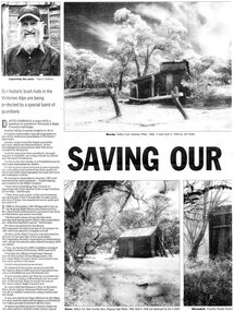
Newspaper article- Double page article. Pages 30 & 83 from the Herald Sun Newspaper. February 18, 2006 regarding preserving Victoria’s High Country Huts
The arrival of explorers Hume & Hovell in 1842 brought about the widespread clearing of land in the valleys for pastoral uses and the displacement the original inhabitants in the high country which became a boon for cattlemen due to extensive lush summer grazing for cattle. High country cattlemen built a variety of huts for shelter and storage, when driving cattle up to the plains in summer, during mustering and bringing the cattle down from the mountains before winter closed in. These same huts now provide shelter from the elements for hikers, bush walkers and skiers. Wallace’s Hut is the oldest of the Cattleman’s huts still standing in the Alpine National Park and is classified under the National Trust. Due to their age and the ravages of the elements, including bush fires, many of the huts have been destroyed, or are falling into disrepair. Groups of willing volunteers are now working to preserve as many of the huts as possible with restoration or rebuilding.The numerous cattleman’s huts of the Alpine National Park and the colourful characters who erected them represent a significant part of the history of the high country area and early cattle grazing, which has been the theme for many poets and film-makers alike. They also have a significant role in the early days of the SECV when they were used by surveyors and other workers for shelter and temporary accommodation. More recently the huts have functioned as shelter for hikers and skiers caught out in the elements and a refuge along the long trek for bush walkers. They are a popular attraction for tourists and feature prominently in much of the tourist information of the region. Black and white double page Newspaper article from the Herald Sun Newspaper of February 18, 2006 regarding the efforts of Mr David Oldfield to preserve Victoria’s remaining High Country Huts through his photography and efforts to restore old and Re-build missing ones. Article shows a photograph of David Oldfield and some of his photographic work of the huts. Page number and date printed at top of each page 30 Herald Sun, Saturday, February 18, 2006 Herald Sun, Saturday, February 18, 2006 83 cattlemen's huts; david oldfield; bogong high plains; wallace's hut; high country; alpine national park -
 Kiewa Valley Historical Society
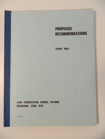
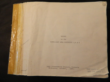
Report - Alpine Area Proposed Recommendations, Land Conservation Council, Victoria Melbourne, April 1978, April 1978
... for Conservation with respect to the use of public land. Notices showing... with respect to the use of public land. Notices showing the boundary ...The Land Conservation Council was established by the Land Conservation Act 1970. It makes recommendations to the Minister for Conservation with respect to the use of public land. Notices showing the boundary of the study area ... published in the Victorian Government Gazette Sept. 1973. A descriptive report was published in July 1977. Submissions (1538) on the future use of public land were received & included those representing a wide cross-section of the community. These were considered in the final report.Of interest for research on the changing ideas regarding the use of public land and the environment.Blue book bound by dark blue cloth tape. It has 92 pages with maps at the end and an empty folder inside the back cover.alpine area, land conservation council, alpine study area report -
 Kiewa Valley Historical Society
Set of 2 hand coloured photographs of early Mount Beauty, photographs of Mount Beauty, 1947/48
Construction of the town of Mount Beauty commenced in 1946 and continued until 1952. It was built to provide family accommodation for workers engaged in the construction of the hydro electric power scheme. As well as housing, there was an administration building, staff hostel, merchandising centre, workmen's camps, base stores and workshops and the Mount Beauty Terminal Station. The first house was occupied in November, 1946 by the then manager of the trading store, with a frontage onto Hollonds Street. The total number of houses erected was 488, 162 custom built and 326 prefabricated. The main workmen's camp can be seen just left of the centre of the photograph and accommodated 144 men at the time of the photograph. By 1950 it could accommodate 1200men. Photo No. 1 is taken in 1947/early 1948 as there is no evidence of the staff hostel under construction. This hostel was commenced in August/September 1948 and is clearly shown in photograph No. 2, dating this photo as 1948 as it is before the completion of the bypass road connecting to the main (high plains) road. This road was constructed in 1939 and in 1948 followed the route of Tawonga Crescent. This remained in use until the bypass construction was completed in early 1949 and does not appear to be finished in this photograph.. Both photographs are taken from the power line easement adjacent to the Bright road.Significant historical pictorial record of the development of a town from grazing land. The type of terrain that had to be surveyed and then to construct roads and other infrastructure, with very little machinery, is also of prime significance in the development of the Kiewa Hydro Electric Scheme.Two photographs, both hand painted to show colours, and both of Mount Beauty c 1947/48 not long after commencement of construction of homes and facilities for workers.Photo No.1 - on back of photo, left upper corner, faintly in pencil, SPIKE, underneath this is written T Pay,. Photo No. 2 - on back of photo, left upper corner, faintly in pencil, Jmount beauty, housing, accommodation -
 Kiewa Valley Historical Society
Report - Land Conservation Council x2, Land Conservation Council, Victoria Melbourne, April 1978, October 1974
... Land Conservation Act 1970 established the Land... to investigate and recommend to the Minister use of public land ...Land Conservation Act 1970 established the Land Conservation Council to investigate and recommend to the Minister use of public land in Victoria. It describes and assesses the natural resources:-Physiography, Geology, Topography, Land Systems, Outdoor Recreation, Public land and blocks. Primary Production. Vegetation.North East Victoria includes the Kiewa Valley. This report gives an understanding of the development of the area.Thick heavy book with 312 pages with black and white photos. Back half has a folder with heavy cardboard attached to thick cardboard back cover. Inside folder are 9 maps with color each with a different title.Stamped on Front Cover: "Mount Beauty High School" Has a library borrowing slip at the back of the last page.land conservation council, environment, public land, kiewa valley, planning -
 Kiewa Valley Historical Society
Folder - Kiewa Methodist Church, 1917 to 1962
The copy of a letter written by Harry H. Simmonds of Huon notes that "the church existed in 1905. It was built by Hill and McCormack with timber donated by Mr Ned Dunstan on ground donated by Mr James Thomas probably in the late 1800s. It was possibly called a Methodist Church because the donor of the land was a Methodist. It was used by the three Protestant Groups and maintenance was paid for by an annual area collection.The house on the west side was a Presbyterian Manse for many years and the block of ground on the north side was known as the Manse paddock in which the minister grazed his cow and horse." In 1936 there was a fence between the Kiewa Methodist Church was the Presbyterian Church in Kiewa. Its Certificate of Title is Volume 5134 Folio 1026783 (Sept. 1942.) In 1952, the church was made of wood with an iron roof. In 1954. Request to Yackandandah Shire re a fence from Kiewa Consolidated School entrance to the unused hedge adjacent to the Church. In 1958 there was correspondence re 'the strip of land on each side of the Church.' Churches were an important part of life during the late 19th century and early to mid 20th century and were built in the centre of town as was this one. These papers give an understanding of the work involved in maintaining a church. The letters and 'book' give a lot of names of local families involved with the Methodist Church at Kiewa. Yellow plastic spiral folder with 18 pages enclosed in clear plastic sleeves.Papers enclosed include accounts, payments, tenders and other correspondence relating to the Methodist Church at Kiewa dating from 1932 to 1962. Of particular interest is a black cardboard cover book dated 1917 re collection of donations from listed people. The latest date in the book is 1942.Enclosed in first plastic sleeve is a letter from the donor, Kathie Vines dated 15th July 2013methodist church; kiewa; harry h. simmonds; yackandandah council; -
 Kiewa Valley Historical Society
Book - Mt Beauty Voters' Roll, Shire of Bright - Voters' Roll 1979 - Mt Beauty Riding, 1979
Electoral roles list people who are registered and eligible to vote at federal, state, territory and local government elections and referenda. Prior to 1990 the rolls list voters in alphabetical order by surname and first names within each Sub-division of an electoral Division of each State or Territory. The roll is useful and interesting for family historians and the study of demographics.Electoral rolls help to locate the residential address of a person in a particular year or over a period of years. They can be used as a substitute for census records for family historians and the history of a particular place, in this case Mt Beauty. Alex McCullough was a resident of Mt Beauty and Councillor in the Bright Shire. 40 pages of firm blue paper with black typed print on one side only in 'landscape' format. Held by three staples. Each page has columns - numbered 1 to 656; Surnames in alphabetical order; Given names; Occupation; Includes L = 'land'; Address followed by Lot number in the Parish of WermatongOn the cover, top right hand corner "Cr McCullough"shire of bright; mt beauty riding; voters roll; parish of wermatong; alex mccullough -
 Kiewa Valley Historical Society
Photograph - 30 black and white photographs (assorted sizes) plus page from a newspaper and copied article on A4 paper, c1880's c1910 - 1920 (photographs) Newspaper 1961
K2,3 and4 are of the Kiewa River and two of the bridges spanning the river along the valley. K3 and K4 would have been taken in the 1880's and show the type of trees and plant growth along the river prior to land clearing for farming. K5 is of the Running Creek Cricket Team and therefore there was sufficient population in the area to form and maintain a team as well as have other teams in the relatively near vicinity to provide competition. Note the horse drawn cart which provided transport. Date taken is unknown but possibly c 1910. The Mt. Buffalo Chalet was built in 1910 by the Victorian Government. It was Australia's first ski resort and has served generations of skiiers, hikers and families over the years. It was built for 3195 pounds and has had stories and wings added since and is the largest timber building in Australia. B4 is the earliest photo in this group as the garden is in early stages of development - the other photos show the growth of the shrubs and would be taken about c 1920. Note the cars and motor bikes. It closed in 2006. The other photos are of general interest only but interesting to see that there were donkey's grazing. There is no information as to their purpose on Mt. Buffalo. Four different Kiewa Valley families are represented in the photographs. Their descendants still live in the Valley and carry on the traditions of beef and dairy farming. Of particular interest is the photo of Miss Marjorie Clemence, the first School Teacher of Upper Gundowring School. Gundowring pastoral run was taken up in 1838 and occupied by framers in the 1860's. The area was known as Gundowring and Upper Gundowring. The Gundowring School was opened in 1871 and most likely the Upper Gundowring school would be built at the same time. It was School No. 2733 and situated in Boyd Road. It closed in 1953 when the Kiewa Consolidated School opened. The newspaper page describes the activities in which the local community of Kergunyah were in engaged in that period - Red Cross, Fire Brigade, cattle round up and some of the identities involved. The article photocopied from the Yackandandah times states that he (Norman Coad) "was sent to the Ovens District Hospital, Beechworth for treatment" which would mean that this was the closest hospital to the Kiewa Valley for emergencies in 1912.The Kiewa Valley photographs are of social significance showing two of the early bridges allowing the community easy access to both sides of the river and also the tree and plant growth before land clearing for farming. The photos of Mt. Buffalo Chalet have social, architectural and historical significance. the Chalet has been used by skiers, bush walkers and day trippers since its completion in 1910 and its closure in 2006. It is listed in the Victorian Heritage Register. The family photographs are of social and historical significance as they are of early farming families in the Kiewa Valley and also depict the dress, of both men and women) in the late 1880's. The write up in the Weekly Times has social significance as it depicts the social and farming activities and photos of the local residents from around that area. The article from the Yackandandah Times is of a personal nature with concern for the individual involved. Note: There is a photo of the gentleman mentioned in the article (Mr. Norman Coad) in the Families of the Kiewa Valley (F4) as above.30 black and white photographs - 5 of the Kiewa Valley, 8 of families of the Kiewa Vallley and 17 of Mt. Buffalo. Various sized photos. Page from the Weekly times and copied article from the Yackandandah Times on A4 sheet.(Note for easier identification they have been numbered and grouped - K1-5 (Kiewa Valley), F1-8 (Families) and B1-17 (Mt. Buffalo). K1: handwritten in ink, lower L hand corner "Bogong in the distance". K2: handwritten in ink lower L hand corner "Mongan's Bridge or Towonga". K3 handwritten in ink "Taken from Mongan Bridge looking up stream". K4 - no inscription. K5: handwritten in ink, back of photo "Running Creek Cricket Team". F1: handwritten in ink on back "Mrs. Heap" and lower down in pencil "1880's". F2 handwritten in pencil at top of back phot "Land at Tawonga TROVE The Y'dah Times 20/2/1913" and lower down in ink "Henry Ellis Larkin". F3: handwritten in ink bottom edge "Mrs Coad". Note that this photo is a postcard. F4: Written in ink lower edge "Norman Coad". Note this photo is also a postcard. F5: Lower left corner in Ink "Harry Larkin". F6: lower half back of photo, in ink "Bernie Maddison". F7: on back of photograph in ink "Miss Marjorie Clemence first School Teacher Upper Gundowring: and underneath, in pencil "C1880's". F8: Handwritten in ink on back of photo "Frank & Mrs. Keat & Lesley of Tawonga". Lower down in pencil "c1912-1914". B1: Back of photo in ink "The Chalet Mt. Buffalo". B2: no inscription. B3: "chalet at Bufflo" in ink lower left corner. B4: This is a post card. Written in ink is "Mt. Buffalo Chalet". B5 - B10 printed in ink, lower left corner "Buffalo". B11: no inscription. B12: "Mt. Buffalo" lower R corner. B13: "Buffalo?". B15: Printed in ink lower edge "Picnic at Buffalo". B16: "Donkeys on Mt. Buffalo" printed in ink lower edge. B17: handwritten in ink across back of photo "Donkeys & top of Mt. Buffalo with the Monileith in the distance". A4 sheet of paper describing an accident to Mr. Norman Coad. Under article is : Yackandandah Times (Vic: 1890 - 1931), Thursday 18 July 1912, page 3. A page torn from the Weekly Times, June 14, 1961 and entitled "Kergunyah has picturesque setting". kiewa valley, farming, families, kergunyah, gundowring upper, mt. buffalo chalet, briggs family, larki family, coad family, clemence family, laskowski collection -
 Kiewa Valley Historical Society
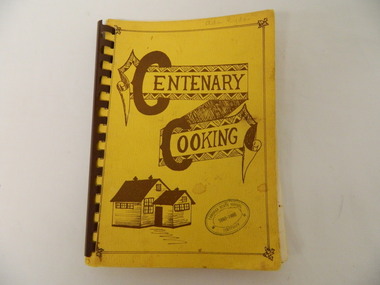
Book - Cooking x2, Centenary Cooking, 1980
The Tawonga School was a weatherboard building built on 8 acres of land catering for children from the surrounding grazing farms to ride their horses to school. It opened on 27th July 1880. The original school building and records were erased by fire in 1900. The Tawonga hall was used until 1910 when 3 acres of land was donated by Frank Cooper. It still operates today (2015) with its numbers having fluctuated over the years with the Kiewa Hydro Electric Scheme, tobacco farming and now tourism. The Tawonga community published a cook book to celebrate the school's centenary.This book may have also been used as a fund raiser.The Tawonga school celebrated its centenary with a cookbook with contributions from the community. This indicates that the school was very proud of reaching its centenary and the community co-operated with each other to develop this book.This book is a good source of the names of people who lived in Tawonga in 1980.Yellow book with brown writing and sketch of school held together with brown hard plastic binding. It has 90 pages of recipes most of which give the contributor's name.Tawonga State School Centenary 1880 - 1980 (stamped on front & back cover) In pencil on front cover: Ada Ryder An advertising for Kelvinator sticker has been stuck on the inside front cover with 18-3-92 written on it & on the inside back cover and 'Energy Rating' sticker.tawonga school. centenary of school. 1880-1980. cooking. food. kiewa valley -
 Warrnambool and District Historical Society Inc.
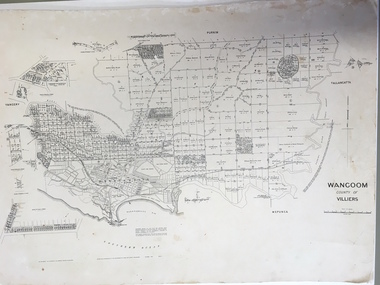
Document: Map, Map Wangoom County of Villiers, 1955
This map contains the names, acreage details and dates of the original property owners of the Parish of Wangoom (County of Villiers), excluding the township of Warrnambool. It also has details of the Crown Lands adjoining the Merri and Hopkins Rivers. This is a most important map as it has details on the original property owners. It is a most valuable research tool and is one of our most-used maps.This is a map, printed in black and white and mounted on cardboard. Where there was intensive land ownership the details have been reproduced in larger print on the margins of the map. There are scuff and dirt marks on the map but it is otherwise in good condition.‘Wangoom, County of Villiers’wangoom, warrnambool, county of villiers -
 Warrnambool and District Historical Society Inc.
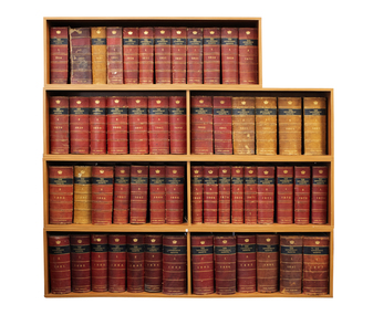
Book (Collection) - Victorian Government Gazettes, Government Printer, Melbourne, Government Gazettes, 1854 to 1895
Warrnambool City CouncilDissemination of Government decisions and actionsWeekly or fortnightly publications bound in volumes according to the yearPrinting of official decisions or actions taken by the Governor of Victoria , Victorian Government authorities, Government Offices, Local Councils , companies and individualsvictorian government gazettes, warrnambool petty sessions, warrnambool customs departmentvictorian government gazettes, warrnambool petty sessions, warrnambool customs department -
 Warrnambool and District Historical Society Inc.
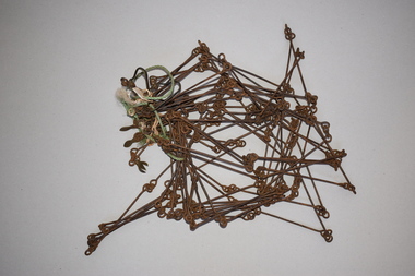
Chain link measure, Gunter, Early 20th century
This Gunter’s Chain, an old land surveying instrument, is named after its inventor, Edmund Gunter (1581-1626), an English mathematician and astronomer. It was first produced in 1620. The tool has 100 links and is 66 feet or one chain long. The links are marked off in groups of ten by metal rings or tags. A quarter chain (25 links) is called a rod or pole and ten chains make a furlong and 80 chains make a mile. The traditional cricket pitch is 22 yards or one chain long. This Gunter’s Chain is of considerable significance because: 1. It is an early land measuring tool that was used for over 250 years and has great historical and mathematical significance. A Gunter’s Chain would have been used when forming and building local roads from the earliest days of settlement. 2. It has a possible local connection as it was given to the Historical Society by a local person in 1965 and possibly came from the property of ‘Rosehill’ This is a metal tool which consists of 100 metal pieces or links joined together by loops at each end with two metal loops in between each link. The links joined together form a chain. The two ends of the chain have small metal handles attached At intervals along the chain there are additional rings or metal pieces attached. Some white and green rope material has been used to bundle up the chain. The metal is somewhat rusted. gunter’s chain, land measurement tools, history of warrnambool -
 Warrnambool and District Historical Society Inc.
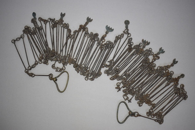
Chain link measure, Gunter's Chain, 19th Century
A Gunter’s Chain, an old land surveying instrument, is named after its inventor, Edmund Gunter (1581-1626), an English mathematician and astronomer. It was first produced in 1620. The tool has 100 links and is 66 feet or one chain long. The links are marked off in groups of ten by metal tags or rings. A quarter chain (25 links) is called a rod or pole and ten chains make a furlong and 80 chains a mile. The traditional cricket pitch is 22 yards or one chain long. This chain is said to have been used by Gilbert Nicol when the Warrnambool to Hamilton Road was constructed in the 19th century. Gilbert Nicol was an early settler in Warrnambool who, with John Craig, established the first hotel (and the first building) in Warrnambool in 1847. Nicol later owned the property ‘Rosehill’ in the Warrnambool area. As the chain was given to the Warrnambool and District Historical Society by the Town Clerk, Keith Arnel, it is likely that the chain was one of the items in the old Warrnambool MuseumThis Gunter’s Chain is of importance because it is an early land measuring device that was used for over 250 years and has great historical and mathematical significance. If it is correct that it was used by Gilbert Nicol when the Warrnambool to Hamilton Road was built then it has considerable local significance and dates back to the 19th century. This is a metal tool which consists of 100 metal pieces or links joined together by loops at each end with two metal loops in between each link. The links joined together form a chain. The two ends of the chain have small metal handles attached. At intervals along the chain there are additional rings or metal pieces attached. The metal is very rusted.gunter’s chain, land measurement tools, history of warrnambool -
 Warrnambool and District Historical Society Inc.
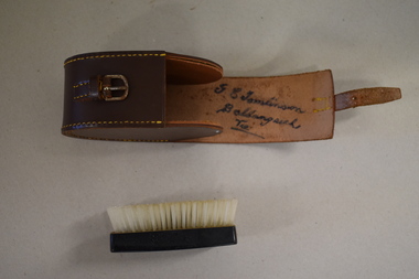
Clothes brush & holder, Mid 20th century
The brush in this case could have been used as a hair brush or a clothes brush. It is enclosed in a leather case and was probably an item made for travellers. The brush and case belonged to George Tomlinson of Ballangeich. Ballangeich is a small settlement on the Hopkins Highway about 27 kilometres from Warrambool. George Tomlinson’s grandfather, William Tomlinson , established a farming property at Ballangeich in 1865 and opened a hotel, ‘Half Way House’ on part of the land. George Tomlinson’s father, also William, continued to farm in the area and was known as a fine judge of cattle and sheep. This case and brush are of interest as an example of the brushes men used in the mid 20th century. The items are also of interest as they belonged to a member of a well-known Ballangeich family (Tomlinsons).1 This is a piece of brown leather rolled over and stitched with yellow thread to form a container or case. The case has a closing mechanism – a leather strap and metal buckle. .2 Inside the leather case is a brush with a brown Bakelite back with horsehair inserted. ‘G.E. Tomlinson Ballangeich Victoria’men’s toiletries, ballangeich, history of warrnambool -
 Warrnambool and District Historical Society Inc.
Map, Department of Lands and Survey (Lithographers), Caramut township, 1938
This map of the township of Caramut was produced in 1938 but shows the original land owners of each town allotment and of the surrounding area. The size of all the allotments and the date of the original purchase are also shown. Caramut is a Victorian Western District town on Mustons Creek on the Hamilton Highway 48 kilometres from Warrnambool. This map was used by Rolf Crawley when he was the engineer for the Shire of Warrnambool from 1935 to 1968. The annotations on the map have probably been made by Rolf Crawley as they refer to the records and letter books of his father, John William Crawley, Junior (Shire of Warrnambool Engineer 1895 to 1935). Both Rolf Crawley and his father, John had private businesses as architects, surveyors and engineers and the map could have been used in connection with both their official Shire duties and their private businesses. The last owner of the map was the surveyor, Michael Hand who took over the business of Rolf Crawley in the late 1960s. This map is of great interest firstly because it has all the historical details of the land first purchased in the town of Caramut and area and secondly because it came from the office of Rolf Crawley, the engineer for the Shire of Warrnambool from 1935 to 1968. This is a buff-coloured paper map with a cloth backing. The map details are in black and white print. There are some handwritten red and black annotations on the map. “Town of Caramut Parish of Caramut County of Villiers’town of caramut, john william crawley junior, warrnambool, rolf crawley, warrnambool -
 Warrnambool and District Historical Society Inc.
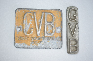
Milking Machine Plates (2), 1950s
These items come from a Gordon Vacuum Break Milking Machine. Vacuum Break milking machines were popular from the 1930s on, with the systems interrupting or breaking the constant milking vacuum, thus avoiding or reducing the harmful effects of vacuum acting constantly on the cow’s teats. An inserted rubber section acted as a valve which affected the pinching action by closing and opening alternately. These items came from a milking machine which was used on the property of Reginald Dalton Hooker and his wife Marjorie. The property was at 155 Rooneys Road, Dennington and twenty cows were milked on land irrigated by a bore. The milk was supplied to the Nestles Factory in Dennington (now Fonterra). These two plates are of interest as they are reminders of the local dairying industry during the mid 20th century. Dairying remains today the chief industry of the Warrnambool district..1 This is a rectangular metal plate with two holes at each end for attachment to a machine and with raised metal lettering on the inside surface. The plate has been painted light brown but the paint is now peeling. .2 This is a small rectangular silver-coloured plate with raised lettering on the front. .1 GVB Gordon Vacuum Break Milker .2 GVBreginald hooker, dennington, gordon vacuum break milkers, history of warrnambool -
 Warrnambool and District Historical Society Inc.
Document, Grasmere Church Dispute, 1882
These papers contain cuttings newspaper articles from the Standard of 1882 and handwritten comments appended to these cuttings. They refer to a dispute in 1882 regarding the ownership of the church in Grasmere to which the Anglican Church was claiming ownership The author of the handwritten comments is unknown but the comments purport to be a more accurate account of events than what appears in the paper cuttings. Grasmere is a small settlement 10 kilometres north of Warrnambool. In the 1850s land in Grasmere was donated for educational purposes and a Government-subsidized school which was a Denominational School run by the Church of England was established in 1858. This school was closed when Government State Schools were established after 1872 and the Anglican Church dismantled the old school and built a church on the site in the late 1870s. This church was erected by public subscription and many of the subscribers apparently believed they were donating to a building that could be used by any local Protestant churchgoers. The church in 1882 was being used by the Presbyterian Church for its services. A public meeting was held in 1882 to try to resolve the dispute between the Anglican Church claim and the local residents’ claim that the site belonged to the local community. Apparently the dispute remained unresolved and the Grasmere Anglican Church continued to operate until the early 20th century. This document is of interest as it is associated with a dispute that took place in Grasmere in 1882 and gives some indication of the arguments that were presented at the time in favour of, or opposed to, the Anglican Church’s claim to the ownership of the church. It is a document of particular interest to the history of the Grasmere. This is a folder of eleven foolscap-size sheets of paper enclosed in a mottle-coloured cardboard cover. The front cover is creased and partly torn and the back cover is detached and is in two pieces. The pages have been stitched together with thread and contain paste-in newspaper cuttings and handwritten material in purple ink. Grasmere Anglican Church -
 Port of Echuca
Photograph - Black and white photograph, Late 1970s
Relates to a series of 5 photos:P000094-P000098 of the front of the Bridge Hotel on the corner of Murray esplanade and Hopwood gardens. These photos, taken about 1976, were before the Port Restoration Scheme renovated the hotel. The Bridge Hotel was built by Henry Hopwood in 1858. This and the Bond Store were Echuca's first 2 brick buildings. Named from Hopwood's nearby pontoon bridge. The building was bought be The Council in 1970. Restored and reopened in 1975.The Bridge Hotel is an important part of Echuca's settlement and development. It was originally built by Henry Hopwood, the European founder of Echuca, in 1859. Hopwood built the hotel to provide accommodation to people using his punts across the Campaspe and Murray rivers that area central to the landscape of the Port. The hotel was situated on the land between both rivers and punts and provided for a variety of levels of accommodation from grand rooms to very basic rooms. At the time of the photos the hotel was 120 years old and became an important part of the Port of Echuca tourism. Black and white photograph of the Bridge Hotel , showing western wing before restoration.Stamped on the reverse "Gazemore Studio, D. G. Gay, 18 Frances Street Echuca 3625.bridge hotel, echcua, port restoration scheme, bridge hotel restoration, echuca -
 Eltham District Historical Society Inc
Photograph, Fay Bridge, Footbridge, Fort Knox Self Storage, 197 Sherbourne Road, Eltham, n.d
The footbridge which extended from the facility to the landscaped garden and water features is now gone. The footbridge and garden were previously part of a former hat factory in Sherbourne Road Eltham which has in the past been used for various purposes and presently a self storage business. The Karingal Yallock Creek passes through the front of the land and the creek environs are the subject of significant and unusual landscaping works, including some cascading water channels. Some of the landscaping was damaged by the Christmas Day floods of 2011, but the main elements remain intact. The landscaped area (as distinct from the factory itself) is the subject of a Heritage Overlay under the Nillumbik Planning Scheme. The basis of this overlay is a Heritage Report by Graeme Butler and Associates in 2006. As well as an assessment of the landscaped area, it includes one background information on the history of the site (although a complete history would require more research). The site was part of Crown Portion 3 of the Parish of Nillumbik that remained as the Montmorency Farm until early in the twentieth century. The 1911 subdivision of this farm created Lot 7 of some seven acres, which is the site of this factory. The Heritage Report lists the various owners of the site. From the rate records and aerial photos it is concluded that the site was used as an orchard and farmland until the 1940s. William F Crellin, orchardist, owned the site from 1912 to 1923. Then Edmund Williams owned it until 1951. In 1955 the site was owned by Rupert V. Kirsch and this is the name anecdotally associated with the hat factory, where the well-known brand of Fayrefield Hats were manufactured. There is some belief that this was built about the time of the Second World War and that hats for the armed forces were made there.fay bridge collection, eltham, fayrefield hat factory, foot bridge, sherbourne road, footbridge, fort knox eltham -
 Eltham District Historical Society Inc
Photograph, Fay Bridge, Ancient Eel trap on the Yarra River at Laughing Waters, Eltham - pre-dating European settlement, 6 September 2023
Laughing Waters is the name for a stretch of the Yarra Valley Parklands consisting of river flats and hilly riparian bushland. With Birrarung (Yarra River) flowing through, Laughing Waters has been an important gathering place for thousands of years. For the Wurundjeri, ‘Garambi Baan’ (the name for Laughing Waters in Woi wurrung) is an important site for growing and harvesting food. Significantly, Wurundjeri iuk (eel) traps remain at Garambi Baan to this day. The Wurundjeri Woi Wurrung People take their name from the Woi wurrung language word ‘wurun’ meaning the Manna Gum (Eucalyptus viminalis) which is common along ‘Birrarung’ (Yarra River), and ‘djeri’, the grub which is found in or near the tree. Wurundjeri are the ‘Manna Gum People’ and their Ancestors have lived on this land for millennia. The site on the Yarra River near the former Morrison property Killeavey was given a language name in 2015 at the instigation of Wurundjeri Elder, Dave Wandin. Garambi Baan means “laughing waters” in the traditional language, Woi wurrung. The site at Warrandyte was rediscovered by Campbell Beardsell OAM in 2007 and is one of only a few known remaining iuk (eel) traps on Country once found the length of the Birrarung (Yarra) and the Maribyrnong. Original Indigenous aquacultural infrastructure was dismantled, taken away from sites and used to build houses, fords and roads by Europeans. The difficult and restricted access to this site is thought to be one of the reasons for its survival. The iuk trap is located within lands managed by Parks Victoria. The Narrap team in partnership with Parks Victoria and Acacia Land Management have been improving the native vegetation with a program of woody weed removal, exclusion fencing and revegetation. Importantly, the team have restored the trap’s infrastructure and have demonstrated its effectiveness.” References: Wurundjeri Woi Wurrung Cultural Heritage Aboriginal Corporation - Laughing Waters. (2023, September 3). Retrieved from https://inplace.org.au/laughing-waters/ GARAMBI BAAN LAUGHING WATERS RESIDENCY CENTRE 2020 2024 Strategic Plan, Nillumbik Shire Council (2023, September 3). Retrieved from https://www.nillumbik.vic.gov.au/files/assets/public/minutes-and-agendas/2020/09-sep/15-sep-cm/ocm.177-20-attachment-1-laughing-waters-arts-program_1.pdffay bridge collection, eel trap, laughing waters, yarra river, wurundjeri woi wurrung, garambi baan, 2023-09-06