Showing 819 items
matching mays park
-
 Federation University Historical Collection
Document, History of the Ballarat Technology Park, Oakbank
The Ballarat Technology Park is associated with Federation University Australia. The first stage commenced on 03 August 1989 when the first sod was turned by Hon, David White, Minister for Industry, Technology and Resources. John Beaumont was the Director of the Ballarat Technology Research and Development Park in 1989.Twenty items relating to the History of the Ballarat Technology Park as collected by John Parkin. .1) Handwritten notes by John Parkin on the history of the Ballarat Technology Park .2) Letter from A.E. Helyar (Shire of Buninyong Secretary), 08 March 1988 .3) Shire of Buninyong Minutes 07 June 1988 .4) Development of High Technology Activity by Jack Barker .5) Definition of a Technology Park by Derek Woolley .6) Shire of Buninyong minutes 28 June 1988 .7) Shire of Buninyong minutes 19 July 1988 .8) Invitation to a reception to commemorate the inauguration of the Ballarat Technology Park (John Parkin) by Shire of Buninyong President Cr Judith Coull to be held on 03 August 1989. .9) Invitation to a reception to the Ballarat Technology Park (John Beaumont) .10) Ballarat Courier article 04 August 1989 .11) Draft letter to Professor Geoffrey Blainey from John Parkin .12) Letter to the Editor from John Parkin, 18 December 2000 .13) University of Ballarat Development Appeal, 04 November 1994 .14 & .15) Invitation to installment dinner to celebrate the installation of Professor Geoffrey Blainey as Chancellor of the University of Ballarat to be held in the Union Building (now Albert Coates Building), Mt Helen campus .16) Letter to the editor from John Parkin .17) Letter from John Beaumont, 25 November 1994 .18) Invitation to the opening of the ISSC Southern Region Data Centre to be held on 24 November 1995. .19) Letter from Barry Traynor, 13 December 1995 .20) Planning Scheme information relating to the LaTrobe Research and Development Zone. .1) 2nd May 2005 History of Technology Park (I.T. centre) The history of the Technology Park started back in the mid-1980s. At the time I was a Buninyong Shire Councilor and as such I was Buninyong's representative on the then Ballarat Development Committee. At one of our meetings we received a request for information on a suitable site for a technology park. The requirements were for a site adjacent to a tertiary institution, secluded for security purposes and large enough to contain such a development. The next morning I contacted our Shire Engineer at the time, Newell Barrett and we drove around the area we both agreed that the current site was the most suitable we saw to meet the requirements. At the time it was owned by George Morrison. however the original enquiry to the B.D.C. came to nothing but the Shire Council and the B.D.C. decided to investigate the possibility of the site becoming a technology Park and information was collected. At about this time Mr Morrison put the property on the market and it was bought by a Ballarat builder, Mr John Beaumont, with the idea of developing it as a residential area. Council then arranged a meeting with Messrs Morrison and Beaumont to discuss the matter. I remember Mr Morrison saying he did not care what was done with it he just wanted to sell it and move down to the coast. Mr Beaumont, on the other hand, said he wasn't ready to retire yet and the idea interested him. As a result a committee consisting of the B.C.A.E., B.D.C. and Buninyong Shire Council (and Mr Beaumont) was formed to plan the development and rezone the area to technology park. It was previously zoned residential land and would seem to have been suitable for sub-division and residential development - its close proximity to the College being a major factor in its favour. The point of this is if Mr Beaumont had insisted on pursuing his original plan and had opposed the rezoning, I am quite confident he would have won an appeal at the A.A.T . (Administrative Appeals Tribunal - forerunner of V.C.A.T.) and the I.T. centre would not have got off the ground and the area would be covered with houses. But Mr Beaumont did go into the project with enthusiasm and the first stage was commenced on the 3rd August 1989 when the first sod was turned by Hon. David White, the Minister for Industry, Technology and resources (See the Courier 4th August 1989) Mr Beaumont went overseas to study similar parks and look for tenants. Unfortunately government did not support the project as they have now and apparently Mr Beaumont was ahead of his time for the private sector so Mr Beaumont could not continue the development and the site eventually passed to the College. I personally think more could have been done ... The work done by the Buninyong Shire Council and Ballarat Development Committee seems to have been forgotten as according to the Courier December 21, 2000 we are told the Park opened in 1995 as a joint venture between the City and the University. As a former Councillor said to me on the day "What happened to the plaque David White unveiled in 1989!" If there is any other information you want, please contact me. You may use my file for reference. Kind regards John Parkin PS I always felt a bit guilty that I encouraged John Beaumont and he was left in the lurch. ballarat technology park, parkin, john parkin, helyar, barker, woolley, shire of buninyong, beaumont, blainey, geoffrey blainey, southern region data centre, greenhill enterprise centre, stan jeffrey, jeffrey, john beaumont, david white -
 Federation University Historical Collection
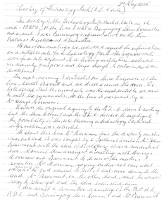
Correspondence, E. Vaughan Morris, National Brass Band Championships of Great Britain to Frank Wright, 1967, mid 1967
Frank Wright was a renown resident of Smeaton, where he was born. He lived at Laura Villa, and attended Smeaton State School. His father William was a gold miner and his mother's name was Sarah. Their family won many singing and instrumental awards. Frank was tutored by Percy Code and was awarded a gold medal for the highest marks in the ALCM examinations in the British Colonies at the age of seventeen years. He became the Australian Open Cornet Champion by the age of eighteen. A year later, Frank conducted the City of Ballarat Band, and later the Ballarat Soldiers’ Memorial Band. He formed the Frank Wright Frisco Band and Frank Wright and his Coliseum Orchestra. These bands won many South Street awards, and Frank as conductor won many awards in the Australian Band Championship contest. In 1933 Frank Wright sailed to England to conduct the famous St Hilda’s Band and was later appointed Musical Director of the London County Council (the GLC or Greater London Council), where he organized many amazing concerts in most of the 150 parks, in and around the London district. He was also responsible for some of London’s major concerts at Kenwood, the Crystal Palace and Holland Park. He was made Professor of Brass and Military Band Scoring and conducted at the Guildhall of Music and Drama. Frank was often invited to adjudicate Brass Band Championships around Europe, in Australia, including South Street and in New Zealand. The Frank Wright Medal at the Royal South Street competition is awarded to an individual recognized as making an outstanding contribution to brass music in Australia.1).Typed letter on National Brass Band Championships of Great Britain letterhead, acknowledging the receipt of a letter and newspaper clippings from Frank Wright regarding band concerts at Royal Albert Hall. 2). Newspaper clipping from the Sun Telegraph on 2/7/1967 about 'Park Music' 3). Newspaper clipping from the Sunday Times on 14/5/1967 entitled 'The Lew Grade of the GLC'1). Typed Letter and signature 2). Written in pen on the front - Sun Telegraph 2.7.67 3). Written in pen on the front - Sunday Times 14 May 67frank wright, e vaughan morris, conductor, london parks, royal albert hall -
 Federation University Historical Collection
Brochure, Besson "Prototype", 1930s?
Frank Wright was a renown resident of Smeaton, where he was born in 1901. He lived at Laura Villa, and attended Smeaton State School. His father William was a gold miner and his mother's name was Sarah. He was the youngest of eleven children. Their family won many singing and instrumental awards. Frank was tutored by Percy Code and was awarded a gold medal for the highest marks in the ALCM examinations in the British Colonies at the age of seventeen years. He became the Australian Open Cornet Champion by the age of eighteen. A year later, Frank conducted the City of Ballarat Band, and later the Ballarat Soldiers’ Memorial Band. He formed the Frank Wright Frisco Band and Frank Wright and his Coliseum Orchestra. These bands won many South Street awards, and Frank as conductor won many awards in the Australian Band Championship contest. In 1933 Frank Wright sailed to England to conduct the famous St Hilda’s Band and was appointed in 1934 as the Musical Director of the London County Council (the GLC or Greater London Council), where he organized many amazing concerts in most of the 150 parks, in and around the London district. He was also responsible for some of London’s major concerts at Kenwood, the Crystal Palace and Holland Park. He was made Professor of Brass and Military Band Scoring and Conducting and was a Fellow of the Guildhall School of Music and Drama. Frank was often invited to adjudicate Brass Band Championships around Europe, in Australia, including South Street and in New Zealand. Frank was awarded an M.B.E. in 1967 and he died in November 1970. The Frank Wright Medal at the Royal South Street competition is awarded to an individual recognized as making an outstanding contribution to brass music in Australia.A yellow, red and white three fold brochure printed in black, advertising the Besson brand brass band instruments, sold by A P Sykes of Melbourne. On the front cover are photographs of two musicians who a giving their approval for these instruments. One is Frank Wright and the other is William S. May.frank wright, brass band, musical instruments, william s may, besson, a p sykes -
 Federation University Historical Collection
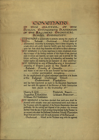
Certificate, Ballarat Technical School Endowment Plantation, 1928, 1928
The School Endowment Plantation Scheme was established in 1922 as a joint venture between the Education Department and the FCV. It was administered by the Education Department with technical supervision by the Commission. While some plantations were established on private land donated or leased for the purpose, most were established on Crown Lands or Reserved Forest made available, without cost, by the State. (https://www.victoriasforestryheritage.org.au/community/schools.html, accessed 26 September 2020) Throughout the Nerrina district numerous areas of public land were set aside as school endowment plantations as part of various schools’ educational resources. The plantations were initially established to instil through community involvement a love of forests and an appreciation of their value, and in fact many of them are well suited for regular use as a teaching resource of this nature. It was expected that this use will increase as courses embracing various aspects of environmental science are developed. Many school plantations have been planted to radiata pine, and revenue from the sale of produce used to provide amenities required by the schools. In some cases, however, these plantations have not been very successful in providing revenue, as the sites are unsuitable for economic growth or the plantations are too small or the location too far from processing centres to allow economic harvesting. In some instances, radiata pine plantations have failed due to poor management. In 1982 the Land Conservation Council believed that all the existing plantations should be assessed in order to establish their value as a teaching resource. Those not needed or that are unsuitable for teaching purposes for some reason, such as their location, should be terminated. Those planted to radiata pine that have limited value as a teaching resource although satisfactory for wood production may continue to be used for such production, but should be reviewed when the pines are harvested. (http://www.veac.vic.gov.au/reports/354-Ballarat-Study-Area.pdf, acccessed 30/03/2017) Three A3 page covenant outlining the 35 acres of Crown Land in the Parish Of Ballarat, County of Grenville, to be granted under permissive occupancy for the establishment of a school plantation to be known as the Ballarat Technical School Endowment Plantation, and two letters relating to same, one on green paper. The Ballarat Technical School Endowment Plantation was at Vale Park, Ballarat. Vale Park is near Norman Street, Ballarat. pine plantation, ballarat junior technical school, alumni, ballarat technical school, ballarat technical school endowment plantation, harry s. gill, augustine f. hesiltine, william h. middleton, frederick brawn, william brazenor, a.w. steane, j.b. robinson, vale park, lindsay hillman, a.j. sutherland, oliver r. roberts, w.a. richardson, w.i. watson, j.g. hopwood, g.f. rumpff, e.j. dalker, john b. colbourn, jack r. collins -
 Flagstaff Hill Maritime Museum and Village
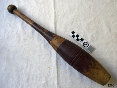
Equipment - Juggling Club, late 19th to early 20th century
This wooden juggling club or exercise club may also be referred to as a juggling pin. It is very similar in shape to a bowling pin or an Indian club. It dates approximately to the early 20th century. It may have been used as one of a pair for gymnastics or exercise, or part of a larger set used by a juggler for entertainment in a circus or carnival. At some time it may have been used with a ball or disc as part of a Skittles or bowling game set. The historical collection of Federation University Australia, Victoria, includes a very similar but slightly shorter club, labelled ‘timber skittle”, as can be seen in their photograph. Another example of very similar-shaped, same-sized clubs can be seen in the collection of Nobelius Heritage Park and Emerald Museum, Emerald, Victoria. JUGGLING Jugglers entertain audiences with their tricks and routines at events such as circuses, amusement parks, parties, shows on television or theatre, schools and parties. Juggles also compete at International Championships to obtain world records, performing as individuals or in groups or teams. Contemporary champion juggler David Cain performs a Juggling History Show that both entertains and educates his audience. His routines date from the early 1600s to the 20th century. He uses a wide variety of equipment in his acts including juggling clubs. EXERCISE Exercise clubs or Indian clubs were used in 19th century Victorian times as part of exercise or strengthening programs when they were swung in certain patterns and movements. Even in the early 20th century workplace a few minutes of Indian club swinging was common practice for the relief of tension. A video clip of an American school room in 1904 shows a group of boys and girls skilfully wielding clubs in an exercise sequence (see ‘Links” section). The 1904 and 1932 Olympic Games had an event called Club Swinging. Rhythmic gymnastics was added to the Olympic Program at the L.A. Games in 1984 where competitors use apparatus such as rope, hoop, ball, ribbon and clubs. The clubs come in a variety of weights and heights and have been used from the mid-1800s until around the 1930s in schools and military institutions. They are decorated in a variety of patterns and colours and some have feature lines or scored rings on them. This juggling club is significant for its association with education, entertainment and sport in the late 19th and early 20th century.Wooden juggling club (or pin, skittle or Indian club). Vintage, bottle-shaped club with a flat, slightly concave, base. Its turned, solid timber body tapers out from the base then in again to a very narrow handle with a round knob joined onto the top. Two concentric feature lines are scored into the wider part of club. It was possibly used in exercise, gymnastics or as a skittle. Sections of the club have two brown painted stripes; paint on the lower strip has been worn off at the base . There are remnants of white paint in two areas, possibly the remains of a maker’s name or decoration. There also appears to be an inscription stamped into the wooden handle but this is illegible. Late 19th to early 20th century.Remnants of what appears to be stamped lettering and painted labelling.flagstaff hill, warrnambool, shipwrecked coast, flagstaff hill maritime museum, maritime museum, shipwreck coast, flagstaff hill maritime village, great ocean road, wooden skittle, entertainment, bowling skittle, wooden juggling pin, wooden juggling club, wooden exercise club, indian club, exercise club, club swinging, rhythmic gymnastics, sport equipment, juggling equipment, wooden club -
 Flagstaff Hill Maritime Museum and Village
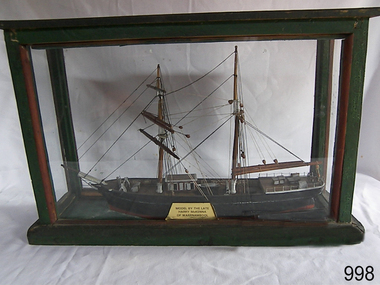
Craft - Ship Model, Mary Campbell, circa 1940
This ship model is of the sailing brigantine MARY CAMPBELL, which once belonged to Captain James Arthur Robilliard. The model was made by Harry McKenna, a well-known ship model maker and Warrnambool resident. CAPTAIN ROBILLIARD James Arthur Robilliard, sea captain and tent maker, was born in 19th April 1843 in St. Helier, Jersey, Channel Islands. He trained there in his father’s sail loft as a sail maker. He later became a skipper. His first job as a sailor was achieved in Liverpool, England. In 1875 James Robilliard migrated to Australia as mate on the “E.M. Young”. Captain Robilliard and his family were amongst the early settlers along the Curdies River in the Heytesbury district. In 1877 he became a Captain. On 14th November 1879 Captain Robilliard married Helen Beckett. James and Helen had ten children; James Arthur (Jnr), Henry William, Nellie Jessie, Alfred Albert, Rubena Nellie, De Jersy Norman, Clifford Beckett, Olive Ida, Frances Ridley Havergal and Nellie Elvie, all born in Victoria. THE MARY CAMPBELL The ship “Mary Campbell” was built by Alexander Newton Jnr. She was carvel planked, of iron bark and blue gum timber. The family shipyard was at Pelican, on the Manning River, NSW, and “Mary Campbell” was first launched by her builder in 1869 as “The Son”. Three months later she was renamed “Mary Campbell’ by her purchaser J. Campbell in Sydney. She was used to carry equipment for the Sydney Sugar Refinery’s Mill in Southgate, NSW. She then traded for the next 20 years between Australian ports and rivers along the east coast as well as regular ports in New Zealand. She was “recognised as one of the best carrying little vessels in the timber trade” (Sydney Morning Herald). She had several owners over this time, the last one being Captain James A. Robilliard. On 29th April 1889 “Mary Campbell”, in the charge of her owner, Captain James A Robilliard, was on her way from Clarence River, NSW to Melbourne, Victoria with a cargo of railway girders for the Melbourne Harbour Trust. Captain Robilliard encountered a storm off Port Macquarie. He sailed the vessel south to 25 miles (about 40km) east of Cape Hawke, near Tuncurry and Forster. At 7pm, he discovered that the cargo had shifted during the stormy seas and the heavy girders had damaged the hull, causing a leak. The pumps were inadequate to stem the fast flowing leak and over a meter of water filled the hull during the next 2 hours. Some of the crew began throwing the cargo overboard to lighten the vessel, hoping to keep it afloat until daylight. When the water reached over 2 meters in the hull they realised their efforts were in vain. At 1:30am on 30th April 1889 the crew left the vessel. They stood by in the lifeboat until 3am. The ship was sinking fast, so they left for the shore, looking for a safe place to beach their boat. While still miles off Cape Hawke all 7 crew members, including the Captain, were rescued by the Government Tug “Rhea” and taken to Port Macquarie hospital then returned to Sydney in the “Wellington”. Captain Robilliard managed to rescue his ship’s compass but no cargo was saved from the vessel. It had been under-insured, only covered for half its value, due to lack of funds. Many years later, in 1976, an anchor was caught up in the net of a trawler south of Forster and thought to be from the “Mary Campbell”. It was donated and installed in the Great Lakes Museum, Tuncurry, NSW. (The same museum also has a half-model of the hull of “Mary Campbell”.) The name of the last ship Captain Robilliard sailed is currently unknown, however he sailed that ship from the port of Marlborough, Queensland, carting steel railway girders for the Geelong-to-Camperdown line. On one trip it hit a storm, the cargo shifted and the ship was wrecked along the NSW coast. After this, Captain Robilliard exchanged sea life for farming in Peterborough. In about 1897, verging on retirement, Capt. Robiilliard superintended the Melbourne Sailors’ Home in Spencer Street, Melbourne, before being asked to leave this position in 1902 for trying to shut down the local hotel! At this time the Melbourne Sailors’ Home was about to change its location. On 6th May 1917 Captain James Arthur Robilliard J.P. died at Blackwood Park, in the Cobden district of Brucknell, which is now considered the first official Robilliard family homestead in Australia. He was buried in the Melbourne General Cemetery, Victoria. His wife Helen passed away in 1947. The Becket and Robilliard family names continue to be well known in the Western District Flagstaff Hill Maritime Village also has a ship’s compass in the collection that was also owned by Capt. J. Robilliard and was used on the ship Mary Campbell.This ship model of the MARY CAMPBELL is of local significance for its association with well known Warrnambool resident and ship model maker. The model is also significant for its association with the brigantine MARY CAMPBELL, a trading vessel that brought railway girders to the Melbourne Harbour Trust.Ship model "Mary Campbell", a two-masted vessel with black hull, brown masts and black rigging. In glass case with timber frame painted green. Painted on the bow in white “MARY CAMPBELL” Gold label with black print attached to display case “MODEL BY THE LATE HARRY McKENNA OF WARRNAMBOOL”flagstaff hill, warrnambool, shipwrecked coast, flagstaff hill maritime museum, maritime museum, shipwreck coast, flagstaff hill maritime village, great ocean road, marine artwork, model making, captain james arthur robilliard, j.a. robilliard, vessel mary campbell, ship mary campbell, melbourne sailors home, vessels, harry mckenna -
 Federation University Historical Collection
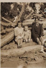
Photograph - Black and White, Mary Elizabeth Holmes and two children
Probably taken at a Holmes family property: "Launchley' or 'Sauchieburn" at Ascot, Ballarat District or "Launchley Park", Derrinallum in the Western District. The latter property was a property Harry and Edith Holmes purchased in 1938 on the return of their eldest son, John Henry [Jack], from WW2. David looks to be wearing his St Patrick's Christian Brother College, Ballarat school uniform. [Jane Dyer, May 2024]Photograph of three children. L- R Mary Elizabeth Holmes, ? [ nephew David Smerdon Holmes] and ? [ brother David Coghill Holmes]chatham-holmes collection, mary elizabeth holmes, ww2, derrinallum, ascot victoria -
 Federation University Historical Collection
Book - Scrapbook, Ballarat School of Mines Scrapbook, 1936-1948, 1936-1948
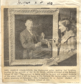
The Ballarat School of Mines was the first school of mines in Australia.Exercise books of newspaper clippings relating to the Ballarat School of Mines. Clippings include: 12 Feb 1936 - State Scholarships 12 March 1936 - Dr J.R. Pound 19 March 1936 - MacRobertson Scholarship 23 March 1936 - gift to the museum - Wardle and Jermyn donate timber specimens 11 May 1935 - A.W. Steane 13 June 1936 - Frederick Longhurst appointed art instructor 27 July 1936 - Ballarat Junior Technical School Reunion 11 Sept 1936 - Wiltshire Poster Competition 30 Oct 1936 - Dressmaking classes 20 NOv 1936 - Nornie Gude NOvember 1936 - Ballarat School of Mines Reunion 16 March 1937 - Oval for Ballarat Junior Technical School - White Flat 11 Nov 1937 - Poster competition - Betty Brown and Albino Paganetti 08 Feb 1938 - Frederick J. Martell obituary 07 July 1938 - Henry Kum-Yuen 14 July 1938 - Red Cross Competition for Women 06 Aug 1938 - School Pine Plantation at Vale Park 19 Aug 1938 - Memorial trees planted at Ballarat Junior Technical School to the memory of Cliff Ellis and Ken Butler 06 March 1939 - Ballarat School of Mines Reunion 16 May 1939 - Ballarat School of Mines Battery 19 April 1940 - Progress of Technical Education - New Engineering workshop opended by Sir John Harris 03 June 1940 - W.H. Middleton obituary 16 July 1940 - Training munition workers 30 May 1941 - Lady Tracers 19 Oct 1942 - War Poster competition 24 February 1944 - Ballarat School of MInes Record Enrolments Feb 1944 - D.F.C. for Ballarat Airman H.J. Trevenen 11 Feb 1945 - Harold Herbert Obituary 14 Oct 1945 - Technical Schools in Wartime 23 Feb 1946 - Molasses and Chaff for SMB Initiates 06 June 1946 - Plans for Victory Ball 13 Sept 1946 - Ken Walker sculpts Prime Minister Chifey's bust 23 Aug 1946 - Edgar McConnon obituary 24 Oct 1946 0 Retirement of A.F. Heseltine 25 Nov 1946 - Army huts for classrooms 12 Dec 1946 - Proposed New Theatre for Ballarat by Geoff Richards 16 Dec 1946 - Ballarat Junior Technical School Old Boys who served in armed forces during World War Two 28 July 1947 - Pottery section at Ballarat School of Mines 31 July 1947 - Red Cross Hut removed to the Ballarat School of Mines 10 March 1948 - Guncotton Factory buildings to become nurses quarters 18 March 1948 - Samuel Mayo Obituary ballarat school of mines, ballarat techncial art school, swimming shield, ballarat school of mines museum, ballarat war museum, sydney pern, t.m. pescott, c.w. brazenor, victory ball, w. rowe, joan walker, graeme dowling, ken walker, prime ministers' avenue, ben chifley, amalie feild, amalie colquhoun, h.h. smith, portrait, girls' preparatory classes, world war two, w. williams, raaf, w.s. williams, william william, william williams, new workshops, herbert j. trevenen, harold herbert death, les crouch, swimming, ballarat city baths, heather scott, clunes hospital nurses' quarters, ballarat ladies' art association scholarships, samuel henry mayo, samuel mayo death, girls preparatory classes, w. william, pilot, killed in action, education reform, ballarat schoool of mines museum, h.j. trevenen, world war ii, world war 2, ballarat junior technical school war service, nurses quarters, guncotton factory building, s. mayo death, initiation, ballarat school of mines scrapbook, newsclippings, j.r. pound, macrobertson scholarship, a.w. steane, ballarat junior technical school, wiltshire's poster competition, ballarat junior technical school old boys' association, ballarat junior technical school old boys' reunion, nornie gude, a. nye, albino paganettu, betty brown, dorothy woolcock, jean coates, jack hewitt, hazel robinson, gilda gude, white flat oval, gauge tower demolition, a.f. hesiltine, darwin, victor greenhalgh, frederick martell, memorial trees, cliff ellis, valda king, pharmacy, reunion, engineering workshops, thomas k. sim, daylesford, battery, h.h. smith reunion, ballarat technical art school reunion, w.h. middleton obituary, munition makers, plumbers, pottery industry, girls education, munition trainees, lady tracers, waterloo prize money, war museum, art as vocation, art education, nine-inch telescope, returned soldiers' league, repatriation classes, pinkertson scholarship, amel robert gordon, projector, pethard cup, ballarat food appeal for britain, queen mary, ballarat swimming pool, ballarat school of mines initiation, swimming carneval, prime ministers avenue, edgar mcconnon, community theatre project, world war two service, john l. burt, hockey, pottery, ceramics, ballarat school of mines coat of arms, coat of arms, k. bremner, red cross hut, s.m.b. follies, ken palmer, s. mayo, chinese, albert steane, university women, a.f. heseltine, student activity, swimming sports, albino pagnetti, w.h. middleton death -
 Red Cliffs Military Museum
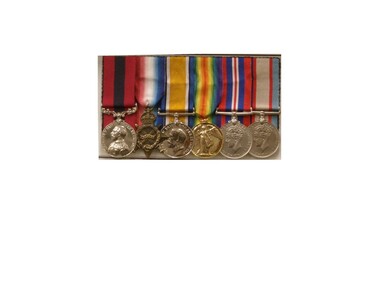
Replica Medals, WW1 & WW11 Medals Awarded to Nathaniel Barclay, (estimated); between 1914 & 1945
Born 5th October 1895 in Adavoyle, United Kindom Occupation Grocer and later horticulturalist Married after WW1- Wife - Daisy Florence Barclay World War One Staff Sergeant Regimental Number 2139 Enlisted AIF in Melbourne 29th December 1914, having previously served 3 months with the Ulster Volunteers and to camp Broadmeadows, to depot Battalion 29th December 1914. Embarked from Melbourne for the middle East with 3rd reinforcement group for the 5th Battalion, 2nd Brigade, 1st Division, 25th February 1915 per transport 'Runic'. Disembarked Alexandria and to camp Heliopolis, Egypt. Operation Gallipoli from 5th May 1915 with 5th Battalion. Sick with dental problems 2nd Field Ambulance 17th September 1915. To hospital Lemnos 20th December 1915. To Alexandria hospital with pluerisy 12th January 1916. Returned to Australia with enteric per 'Nestor' 9th February 1916.To duty Broadmeadows 4th April 1916. Wmbarked with 4th reinforcements group for the 58th Battalion, 15th Brigade per transport 'Themistocles' 1st August 1916 Returned to England 14th September 1916. Operations France and Flanders from 6th December 1916. To 59th Battalion 29th December 1916. To 5th Division Infantry School 18th February to 28th March 1917 as Lance Corporal. Corporal 7th April 1917. Sergeant 2nd May 1917. To 3rd Southern General Hospital Oxford 4th October 1917. Returned to Melbourne per Transport 'Persic' 12th February 1918. Discharged 14th March 1918. Second World War. Regimental Number V5571 Emlisted in the Australian Military Forces in Royal Park, Melbourne 22nd August 1940 and to 2nd Infantry Training Battalion, Fyansford. Staff Sergeant 24th August 1940. To 2/14th Training Battalion Wangaratta 11th October 1940. To 2/23rd Training Battalion, Wangaratta 18th October, 1940.To Southern Command Training School 26th May 1941.to Camp Bonegilla 15th May 1942. To Camp Caulfield 11th November 1942. Discharged to Reserve Occupation 19th November 1942. Remarks. Awarded 1915-15 Star, British War Medal, and Victory Medal 1914-1919 Awarded Distinguished Conduct Medal as Lance Corporal vide London Gazette 30111 of 31st July 1918. Citation for action on 9th July 1917 during the third Battle of Ypres reads- " For conspicous gallantry and devotion to duty. He rendered invaluable service during operation in carrying important messsages through heavy fire" Awarded War Medal and Australian Service Medal 1939-45 in 1951. Described as 71.5inches tall, medium complexion, blue eyes and brown hair. He died 11th September 1962.WW1 - Distinguished Conduct Medal 1914/15 Star 1914/18 British War Medal Victory Medal WW11 - 1939/45 British War Medal Australian Service Medal 1939/45 All medals with associated coloured ribbons. These are replica medals made in the exact metals as the originals. Also in display is a record of War Service which can be found in the narrative. Noneservice, medal, 1918, citation, ww1, military, gazette, london, ww11, medals, 30111, 31st, july, ypres, distinguished -
 Ringwood and District Historical Society
Newspaper, Scrapbook Clipping, Library Collection, Ringwood, Victoria
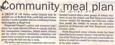
Newspaper Clipping from "The Post", 12 May 1993, Page 7, "Communiy meal plan"'.A group of 140 Italian senior citizens may be granted use of Bedford Park youth hall and kitchen one day a week to prepare and eat a traditional Italian meal together in Ringwood. Ringwood Council's policy and resources committee directed officers to consult with the hall management committee, Italian senior citizens and the senior citizens' consultative committee and report back to council on the possibility of the Italian group using the hall one day a week. -
 Ringwood and District Historical Society
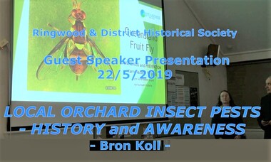
Mixed media - Video, RDHS Guest Speaker Presentation - "Local Orchard Insect Pests" - Bron Koll
Digitised video (3.86GB). Duration: 75 minutes. Recorded May, 2019. (Video is available for viewing at Ringwood & District Historical Society Archives by appointment)Presenter: Bronwyn Koll grew up on her family’s orchard in Wonga Park. In this historical perspective on the first industry of Ringwood, Bron talks about her orchardist roots and highlights the seriousness of looking after crops with the ongoing threat of insect pests in the district, including backyard gardens. -
 City of Moorabbin Historical Society (Operating the Box Cottage Museum)
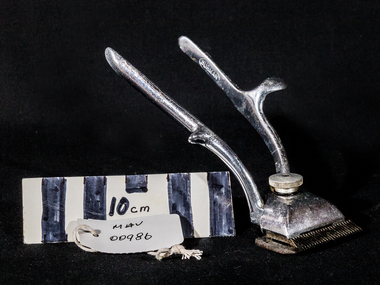
Barbers' Equipment, hair clippers 'BURMAN", c1950
Hair clippers are specialized implements used to cut human head hair. They work on the same principle as scissors, but are distinct from scissors and razors. :Hair clippers comprise a pair of sharpened comb-like blades in close contact one above the other which slide sideways relative to each other, a mechanism which may be manual or electrical to make the blades oscillate from side to side, and a handle. The clipper is moved so that hair is positioned between the teeth of the comb, and cut with a scissor action when one blade slides sideways relative to the other. Friction between the blades needs to be as low as possible, which is attained by choice of material and finish, and frequent lubrication. Hair clippers are operated by a pair of handles that are alternately squeezed together and released. Barbers used them to cut hair close and fast. The hair was picked up in locks and the head was rapidly depilated. Mid 20thC such haircuts became popular among boys, and young men in the military and in prisons. Burman & Sons Ltd, of Ryland Road, Birmingham, West Midlands, manufactured Burman-Douglas steering gear. Their recirculating worm and ball design of steering gear was fitted to pre-war vehicles such as the Ford Eight and the Ford Prefect, the Bedford CA, plus heavy trucks and off-road vehicles - both pre and post-war. In its day, Burman-Douglas steering-gear was regarded as.... a "quality" feature of a car chassis specification, but the worm and ball design was eventually surpassed by the cheaper rack and pinion design that dominates today. The company also manufactured motorcycle gearboxes, horse clippers and barbers’ clippers. 1871 Company founded. 1897 Private company. 1930s Gearbox for Ariel Square-four motorcycle. (Exhibit at Birmingham Thinktank museum) 1933 Burman and Sons Limited, manufacturers of horse and barbers' clippers, sheep shearers, motor cycle gear boxes and steering gears, Ryland road, Edgebaston 1953 S. F. Burman, M.B.E., Managing Director, Burman and Sons, Ltd 1955 Acquired by Vono Industrial Products. 1961 Manufacturers of motor and motorcycle accessories. 1,500 employees. 1968 Supplied rack and pinion steering units to Ford 1978 Adwest Group acquired Burman and Sons, the steering gear part of Duport. 1986 Major reduction in staffing at Burman due to fall in demand for its products and delivery problems. A set of hand held barbers’ hair clippers with an adjustable screw, from Burman and Sons Ltd of Birmingham, England. Chrome plated, in good condition, c1950. On left arm ; BURMAN On right arm ; MADE IN ENGLANDbarbers, hairdressing, hair clippers, grooming, horse clippers, cars, motor cycles, gear boxes, rack and pinion , worm and ball, steering gears, steel manufacture, birmingham england, burman and sons ltd, moorabbin, bentleigh, ormond, cheltenham, market gardeners, -
 City of Moorabbin Historical Society (Operating the Box Cottage Museum)
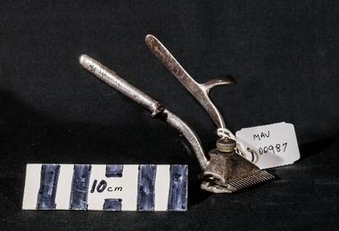
Barbers’ Equipment, hair clippers steel, c1950
Hair clippers are specialized implements used to cut human head hair. They work on the same principle as scissors, but are distinct from scissors and razors. :Hair clippers comprise a pair of sharpened comb-like blades in close contact one above the other which slide sideways relative to each other, a mechanism which may be manual or electrical to make the blades oscillate from side to side, and a handle. The clipper is moved so that hair is positioned between the teeth of the comb, and cut with a scissor action when one blade slides sideways relative to the other. Friction between the blades needs to be as low as possible, which is attained by choice of material and finish, and frequent lubrication. Hair clippers are operated by a pair of handles that are alternately squeezed together and released. Barbers used them to cut hair close and fast. The hair was picked up in locks and the head was rapidly depilated. Mid 20thC such haircuts became popular among boys, and young men in the military and in prisons. A set of hand held barbers’ hair clippers with an adjustable screw. Chrome plated, in good condition, c1950 barbers, hairdressing, hair clippers, grooming, horse clippers, steel manufacture, moorabbin, bentleigh, ormond, cheltenham, market gardeners, -
 City of Moorabbin Historical Society (Operating the Box Cottage Museum)
Photograph, Newspaper article, 'Reconstruction of Box Cottage’ 1984, 1984
... of Box Cottage in Joyce Park Ormond May 1984. Mrs H. Deam and Mr ...The original small, pioneer cottage was built in the late 1840s to early1850s, by an unknown pioneer. It was located on part of a 30 Acre allotment that was originally part of Dendy’s Special Survey granted in 1841. The doors and window sashes, (made of red deal joinery timber), as well as the brass locks and fittings, are from the original cottage, and were imported from England. The fire-place bricks are from the original cottage, and are sun-dried, (not kiln fired), and are hand-made. Convict marks can be seen on two bricks. There is a small display of external cladding shingles from the original pioneer cottage. These shingles were hand-split, and most likely made from locally collected timber The nails included in this display were used to fasten the shingles on the original cottage, and are also hand-made. The cottage was occupied by William Box and family from 1865 until 1914 when it was sold to William Reitman who resided there until 1950. The enamel nameplate, “Colonial”, on the wall of the cottage, was the name chosen for the original pioneer cottage by Mr William Reitman, when he purchased the property in around 1915, for 1200 Pounds approximately. In 1974 Mr Lewis, a timber specialist, found the dilapidated building on property he had recently purchased in Jasper Rd and suggested it be reconstructed and relocated. Moorabbin Council agreed and the cottage was rebuilt just about 250 metres from its original site. The cost of the rebuild was met by 'Victoria's 150th Committee, plus a small grant from the City of Moorabbin, and Mr Laurie Lewis donated much of the timber for the reconstruction. The re-constructed cottage plan has followed faithfully the original dimensions, and plan of the original pioneer cottage, and as many original items from that cottage’s long occupation have been incorporated. The photographs in Album 1 record the progress of the reconstruction from February 1984 to the First Public Open Day November 18th 1984The Moorabbin Standard was the local newspaper for the City of Moorabbin during the 20thCentury until it was absorbed into The Leader Newspaper Group Pty Ltd. This article shows the builder Mr Arthur Smith working on the roof shingles during the reconstruction of Box Cottage in Joyce Park Ormond May 1984. Mrs H. Deam and Mr A. Smith, CMHS members,kept this article to record the progress of the ‘Reconstruction’ from February 1984 to November 1984. A Moorabbin Standard Newspaper article, May 9th 1984, with 2 x black and white photographs of the builder, Mr Arthur Smith, working on the Roof shingles during the reconstruction of Box Cottage in Joyce Park , Ormond. Written on article ; Moorabbin Standard, May 9th Wed. 1984brighton, moorabbin, highett, ormond, mckinnon, cottages, pioneers, colonial, dendy henry, box william, box elizabeth, reitman william, convicts lewis timber co. ltd., deam h, smith arthur, museums, box alonzo, moody & smith builders highett, the moorabbin standard newspaper, the leader newspaper pty ltd., -
 City of Moorabbin Historical Society (Operating the Box Cottage Museum)
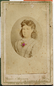
Photograph, B&W, possibly a daughter of Henry Box 1839 - 1921
A black and white photograph of a young girl who may be a daughter of Henry Box 1839 - 1921Bensen & Stevenson Photos / 108 Elizabeth St. Melbourne / COPIES CAN BE OBTAINED AT ANY TIME -
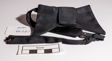
 City of Moorabbin Historical Society (Operating the Box Cottage Museum)
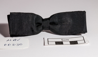
Accessory - Clothing, bow tie, black , spring clip, 20thC
The Bow Tie is a type of men's necktie that consists of a ribbon of fabric tied around the collar in a symmetrical manner such that the two opposite ends form loops. Ready-tied Bow ties are available, in which the distinctive Bow is sewn and a band goes around the neck and clips to secure. Bow ties may be made of any fabric material, but most are made from silk, polyester, cotton, or a mixture of fabrics. The Bow tie originated among Croatian mercenaries during the Prussian wars of the 17th century when the Croat mercenaries used a scarf around the neck to hold together the opening of their shirts. This was soon adopted under the name cravat, derived from the French for "Croat", by the upper classes in France, then a leader in fashion, and flourished in the 18th and 19th centuries. The most traditional Bow ties are usually of a fixed length and are made for a specific size neck. Sizes can vary between approximately 14 and 20 inches just like a comparable shirt collar. Fixed-length Bow ties are preferred when worn with the most formal wing-collar shirts, so as not to expose the buckle or clasp of an adjustable Bow tie. Bow ties are worn by magicians, country doctors, paediatricians, lawyers, professors musicians and by people hoping to look like the above and clowns also wear oversized ones. In the 1980’s fashionable and professional women wore a type of Bow tie. Most men only wear Bow ties with formal dress. A man's pre-tied black bow tie with a metal spring clip to attach to the shirt collar. The 2 spring clips have 'alligator teeth' to grip the collaron spring clip MADE IN AUSTRALIA SPRINGmenswear, clothing, bow ties, cheltenham, moorabbin, bentleigh, early settlers, pioneers, market gardeners, male neckwear -
 City of Moorabbin Historical Society (Operating the Box Cottage Museum)
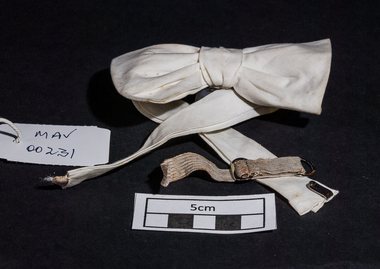
Clothing - Clothing, bow tie, white , elastic clip, 20thC
The Bow Tie is a type of men's necktie that consists of a ribbon of fabric tied around the collar in a symmetrical manner such that the two opposite ends form loops. Ready-tied Bow ties are available, in which the distinctive Bow is sewn and a band goes around the neck and clips to secure. Bow ties may be made of any fabric material, but most are made from silk, polyester, cotton, or a mixture of fabrics. The Bow tie originated among Croatian mercenaries during the Prussian wars of the 17th century when the Croat mercenaries used a scarf around the neck to hold together the opening of their shirts. This was soon adopted under the name cravat, derived from the French for "Croat", by the upper classes in France, then a leader in fashion, and flourished in the 18th and 19th centuries. The most traditional Bow ties are usually of a fixed length and are made for a specific size neck. Sizes can vary between approximately 14 and 20 inches just like a comparable shirt collar. Fixed-length Bow ties are preferred when worn with the most formal wing-collar shirts, so as not to expose the buckle or clasp of an adjustable Bow tie. Bow ties are worn by magicians, country doctors, paediatricians, lawyers, professors musicians and by people hoping to look like the above and clowns also wear oversized ones. In the 1980’s fashionable and professional women wore a type of Bow tie. Most men only wear Bow ties with formal dress. A pre tied white Bow tie sewn on a neckband with an elastic clip fastenermenswear, clothing, bow ties, cheltenham, moorabbin, bentleigh, early settlers, pioneers, market gardeners, male neckwear -
 City of Moorabbin Historical Society (Operating the Box Cottage Museum)
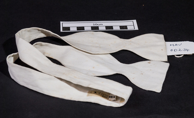
Clothing - Clothing, bow tie white, fixed length, 20thC
The Bow Tie is a type of men's necktie that consists of a ribbon of fabric tied around the collar in a symmetrical manner such that the two opposite ends form loops. Ready-tied bow ties are available, in which the distinctive bow is sewn and a band goes around the neck and clips to secure. Bow ties may be made of any fabric material, but most are made from silk, polyester, cotton, or a mixture of fabrics. The Bow tie originated among Croatian mercenaries during the Prussian wars of the 17th century when the Croat mercenaries used a scarf around the neck to hold together the opening of their shirts. This was soon adopted under the name cravat, derived from the French for "Croat", by the upper classes in France, then a leader in fashion, and flourished in the 18th and 19th centuries. The most traditional Bow ties are usually of a fixed length and are made for a specific size neck. Sizes can vary between approximately 14 and 20 inches just like a comparable shirt collar. Fixed-length Bow ties are preferred when worn with the most formal wing-collar shirts, so as not to expose the buckle or clasp of an adjustable bow tie. Bow ties are worn by magicians, country doctors, lawyers, paediatricians, professors musicians and by people hoping to look like the above and clowns also wear oversized ones. In the 1980’s fashionable and professional women wore a type of Bow tie. Most men only wear Bow ties with formal dress. This white bow tie is a 'fixed length' type that needs to be tied by the person wearing it. MAKO SIZE 15 1/2 menswear, clothing, shirts, collars, early settlers, fashion, cheltenham, moorabbin, dairy farmers, market gardeners, bow ties, mako pty ltd -
 City of Moorabbin Historical Society (Operating the Box Cottage Museum)
Accessory - Clothing, black bow tie, c1960
The Bow Tie is a type of men's necktie that consists of a ribbon of fabric tied around the collar in a symmetrical manner such that the two opposite ends form loops. Ready-tied bow ties are available, in which the distinctive bow is sewn and a band goes around the neck and clips to secure. Bow ties may be made of any fabric material, but most are made from silk, polyester, cotton, or a mixture of fabrics. The Bow tie originated among Croatian mercenaries during the Prussian wars of the 17th century when the Croat mercenaries used a scarf around the neck to hold together the opening of their shirts. This was soon adopted under the name cravat, derived from the French for "Croat", by the upper classes in France, then a leader in fashion, and flourished in the 18th and 19th centuries. The most traditional Bow ties are usually of a fixed length and are made for a specific size neck. Sizes can vary between approximately 14 and 20 inches just like a comparable shirt collar. Fixed-length Bow ties are preferred when worn with the most formal wing-collar shirts, so as not to expose the buckle or clasp of an adjustable bow tie. Bow ties are worn by magicians, country doctors, lawyers, paediatricians, professors musicians and by people hoping to look like the above and clowns also wear oversized ones. In the 1980’s fashionable and professional women wore a type of Bow tie. Most men only wear Bow ties with formal dress. A man's pre tied black bow tie with an elastic fastening clipmenswear, neckties, bow ties, cheltenham. moorabbin, bentleigh -
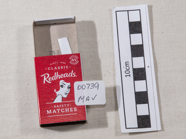 City of Moorabbin Historical Society (Operating the Box Cottage Museum)
Manufactured Objects, safety matches 'Redheads' 2015, c2015
This is a current example of the 'Redhead' logo used by Bryant & May Ltd Richmond,Victoria, Australia c 1946 - 1980 On 15th December 1909, Bryant & May, Australia’s first match factory at Church Street, Richmond, Victoria. was opened by The Honourable Alfred Deakin, Prime Minister of Australia, and Mrs. Deakin. It was heralded by the first Commonwealth Government of newly-federated Australia because the government of the day was anxious to encourage secondary industry and pledged tariff protection of local manufacturers. The building was constructed in 1909 as the Empire Works to a design by prolific Melbourne architect William Pitt and was purchased soon after by British safety match manufacturer Bryant and May, who significantly expanded the building, adding another level and the landmark clock tower. Bryant and May were unique in that they operated as a model factory, providing workers with conditions and amenities that even today seem generous. These included a dining hall and sports facilities such as a tennis court and bowling green which were constructed in the 1920s. Bryant and May ceased Australian match manufacture in the early 1980s as a result of import competition. Their iconic Redheads matches are now imported from Sweden. The complex has since been converted for use as offices and showrooms but is extremely well preserved. It is listed on the Victorian Heritage Register. Bryant and May was a United Kingdom (UK) company created in the mid-nineteenth century specifically to make matches. Their original Bryant and May Factory was located in Bow, London. They later opened other match factories in the United Kingdom and Australia, such as the Bryant and May Factory, Melbourne; and owned match factories in other parts of the world. Bryant and May survived as an independent company for over seventy years, but went through a series of mergers with other match companies and later with consumer products companies. To protect its position Bryant and May merged with or took over its rivals. In 1971 the Northern Ireland factory, Maguire & Patterson closed down following a terrorist attack.. In the 1980s, factories in Gloucester and Glasgow closed too leaving Liverpool as the last match factory in the UK, until December 1994. . The registered trade name Bryant and May still exists and it is owned by Swedish Match Industries as are many of the other registered trade names of the other, formerly independent, companies within the Bryant and May group. Two French chemists, Henri Savene and Emile David Cahen, proved in 1898 that the addition of phosphorus sesquisulfide meant that the substance was not poisonous, that it could be used in a "strike-anywhere" match, and that the match heads were not explosive. British company Albright and Wilson, was the first company to produce phosphorus sesquisulfide ( Red Phosphorous) matches commercially. The company developed a safe means of making commercial quantities of phosphorus sesquisulfide in 1899 and started selling it to match manufacturers. Matches were first produced by Bryant & May in Australia in 1909. The Redhead name applies to the red striking heads of the matches which were introduced to Australia in 1946. The logo on the matchbox depicted the head and shoulder of a redheaded woman and has had four major updates since that time with a number of special issues depicting animals, birds and notable persons also producedThe Bryant & May Ltd factory in Church St Richmond is a listed building and has been converted to apartments following the closure of the Company 1980. Bryant & May's Ltd were influential in fighting against the dreadful disease known as Phossy jaw which was caused by white phosphorus used in the manufacture of the early matches. They were also the object of the 'Match Girls Strike' in London 1888, which won important improvements in working conditions and pay for the mostly female workforce working with the dangerous white phosphorus. The public were slow to purchase these safety matches because of the higher price An empty box of 'Redheads' safety matches made in Sweden for ST-Group, Springvale, Victoria, Australia c2015. The tray for the matches slides inside the open ended cover. The striking patch is on both sides of the cover. The matches have been removed. Matches were first produced by Bryant & May in Australia in 1909. The Redhead name applies to the red striking heads of the matches which were introduced to Australia in 1946. The logo on the matchbox depicted the head and shoulder of a redheaded woman and has had four major updates since that time with a number of special issues depicting animals, birds and notable persons also produced. Bryant and May ceased Australian match manufacture in the early 1980s.Top of cover ; Redheads / 45 safety / matches . Logo ; head & shoulders of a female with red hair Base of coverMade in Sweden / Redheads (R) is proudly marketed / by ST- Group Australia. / 718 Princes Highway Springvale Vic. 3171 / .............../ Readheads is a registered trademark / of Swedish Match Industries AB. / Complies ith European / Match Standard EN 1783-1997-SAF/ WARNING; / KEEP OUT OF REACH / OF CHILDREN. STRIKE / GENTLY AWAY FROM BODY . / barcode.redheads safety matches, safety matches, bryant & may pty ltd, phossy jaw disease, early settlers, moorabbin, bentleigh, cheltenham, lights, lamps, tobacco, white phosphorous, phosphorus sesquisulfide, swedish match pty ltd, pitt william, savens henri, cahen emile david , richmond victoria, match girls strike 1888, -
 City of Moorabbin Historical Society (Operating the Box Cottage Museum)
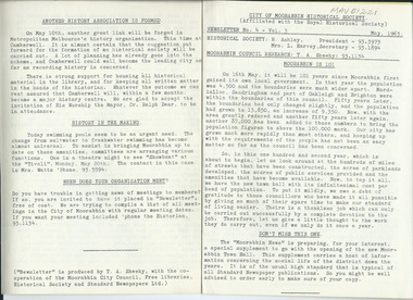
Newsletter, City of Moorabbin Historical Society No. 4 Vol. 3 May 1963, City of Moorabbin Historical Society Newsletter No. 4 Vol. 3 May 1963, 1963
This is Newsletter No. 4 Vol. 5 produced in May 1963 by Mr T. A. Sheehy, CMHS, for members and visitors Topic ; Moorabbin 1901, Dr F Joyce The Aims of the CMHS are ‘to record the history of the City, and register something of the Australian Atmosphere, which the necessary speed-up in post-world-war two (WW11) immigration has caused to be lost; to produce a magazine at regular intervals, featuring the work of pioneers and the changing Australian scene; to work constantly with a long range view towards building a hall where records and exhibits can be housed’ (1961) The Original Newsletters reflect the history and heritage of the former City of Moorabbin — derived from Mooroobin, ‘a resting place’ in the Bunurrung spoken language. In 1994, the City of Moorabbin was integrated into the Cities of Bayside, Glen Eira, Kingston and Monash. This is Newsletter No. 4 Vol. 3 of the CMHS May 1963 CMHS obtained a Kingston City Council Community Grant 2016 for the digitization and preservation of these Original CMHS Newsletters commenced in 1961 1 x Foolscap paper printed on 2 sides folded for 4 pages CITY OF MOORABBIN HISTORICAL SOCIETY / (Affiliated with the Royal Historical Society ) / NEWSLETTER No 4 Vol. 3 May 1963 / HISTORICAL SOCIETY; President ; R Ashley ...... / Secretary; Mrs L. Harvey……./ MOORABBIN COUNCIL RESEARCH : T.A.Sheehy city of moorabbin historical society 1961, sheehy t.a., harvey l, , cheltenham & district co-operative society limited, ashley r, moorabbin city council, standard newspapers ltd., bent thomas, dr joyce fleming, -
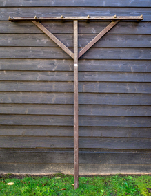 City of Moorabbin Historical Society (Operating the Box Cottage Museum)
Farm Equipment, Rake, large Hay c1900, c1900
A hay rake is an agricultural rake used to collect cut hay or straw into windrows for later collection (e.g. by a baler or a loader wagon). It is also designed to fluff up the hay and turn it over so that it may dry. The next day it is spread again, so that the hay dries more quickly. Early settlers established productive market gardens, poultry,. pig and dairy farms , orchards and vineyards on the land in the 'Henry Dendy Special Survey Brighton 1841' - now Ormond, Bentleigh, East Bentleigh, Brighton, This hay rake is typical of the type used by early settlers in Moorabbin Shire c1900Large wooden Hay rake , hand made c1900farm equipment, hay rakes, hammers, early settlers, market gardeners, blacksmiths, tools, building equipment, moorabbin shire, bentleigh, mckinnon, highett, cheltenham,ormond -
City of Moorabbin Historical Society (Operating the Box Cottage Museum)
Newsletter, City of Moorabbin Historical Society No. 1 Vol. 5 March / April 1965, City of Moorabbin Historical Society, Newsletter No.1 Vol. 5 March / April 1965, 1965
This is Newsletter No 1 Vol. 5 produced in March / April 1965 by Mr T. A. Sheehy CMHS for members and visitors. The Original Newsletters reflect the history and heritage of the former City of Moorabbin — derived from Mooroobin, ‘a resting place’ in the Bunurrung spoken language. In 1994, the City of Moorabbin was integrated into the Cities of Bayside, Glen Eira, Kingston and Monash. Topics The History of the 20thC from 1900-1915 ;next Meeting at Cheltenham State School May 20th ; 'Three Pieces of Paper' by Nance Blackman from "Moorabbin News' Oct . / Nov. 1907 This is Newsletter No. 1 Vol. 5 of the CMHS March / April 1965 CMHS obtained a Kingston City Council Community Grant 2016 for the digitization and preservation of these Original CMHS Newsletters commenced in 1961 2 x L 26cm x W 21cm 1x page printed both sides CITY OF MOORABBIN HISTORICAL / SOCIETY / - Affiliated with the Royal Historical Society of Victoria - / President ; R Ashley ...... / Secretary; Mrs L. Harvey……./ Treasurer Mrs D.M.Wright ..../ Historian : T.A.Sheehy. / NEWSLETTER March / April Vol.5 No 1 1965 -
 City of Moorabbin Historical Society (Operating the Box Cottage Museum)
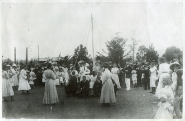
Photograph, Black & White Maypole Dance 1890, c1890
Originally, May Day was a holiday of ancient tradition in England to celebrate the arrival of Spring. It was celebrated with joyous dancing around a garlanded pole , called a Maypole, from which streamers/ ribbons hung. Each dancer held the end of a streamer, and as they danced, the ribbons became entwined creating one of the several traditional and colourful patterns. In Australia, 19thC & early 20thC, Maypole dancing was incorporated in some School's curriculum. as it was deemed to be 'lady like' exercise for girls.The Maypole dance was spectacular when performed for special occasions. It required precision 'drilling' with many rehearsals to prevent any mistakes in the routine. ( H. Stanley 2007 CMHS )Early settlers in Moorabbin Shire enjoyed coming together to celebrate various events by organising a Maypole dancing display and this reminded them of their homeland customs.Black & White photograph of community Maypole dance c1890 -
 City of Moorabbin Historical Society (Operating the Box Cottage Museum)
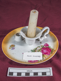
Domestic object - Furnishings, bedroom candle stick holder, Circa late 1880s
Prior to the installation of gas and electric light, pioneers used candles for lighting after sunset. This ornate candle-stick holder most likely was used in the bedroom. The family of Miss May Curtis were early settlers in Moorabbin ShireSmall white ceramic candle stick holder with pink and yellow floral transfer-printed decoration on the rim. There is also a small raised area on the rim to hold a candle-snuffer. On one side there is a small ceramic "loop" attached as a carrying handle. This item broken beyond repair by brush tailed possum when he entered Cottage via chimney 27/4/2014furnishings, lights, lamps, candles, early settlers, pioneers, moorabbin, bentleigh, ormond, brighton, kitchenware, curtis may, market gardeners -
 City of Moorabbin Historical Society (Operating the Box Cottage Museum)
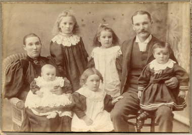
Photograph - Photograph, 1910 Mr W Harvey, 1910 Mr W Harvey, 1910
1910: Mr W. Harvey and Family of Cheltenham. In 'Moorabbin a Pictorial History1862 - 1994' by John Cribbon, William Harvey, is shown in the 1862 Rate Book, to be the owner occupier of a paling house in Argus Road valued at 15 Pound. This person may be related to the W Harvey in the photo.Photograph is black and white. In this photograph their is a father and mother, and their five children. The mother and the children are all dressed in their best dresses. The father is wearing a suit with a waistcoat and a white shirt that has a winged collar but no tie The mother and father are both sitting on separate chairs, mother to the left and the father on the right. The mother has the baby on her lap and the father has a small child on his lap. Three girls are in the middle of the mother and the father.Front of Mount :Yeoman Co 287 Chapel St. Prahran Victoria. Back of Mount : W. Harvey & family / pheteonham / about 1910mr w harvey, 1910, family of cheltenham, argus road, cheltenham, early settlers, market gardeners, moorabbin shire, brighton, bentleigh, cheltenham, dendy's special survey 1841, two acre village, cribbon john, dairy farmers, poultry farmers, -
 City of Moorabbin Historical Society (Operating the Box Cottage Museum)
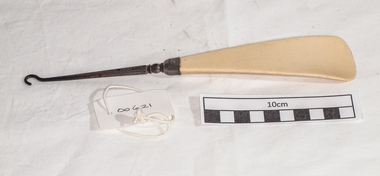
Clothing, button hook, c1900
A button hook is a tool used for the closing of shoes, gloves or other apparel that uses buttons as fasteners. It consists of a steel hook fixed to a handle that may be simple or decorative. The hook end is inserted through the buttonhole to capture the button by the shank and draw it through the opening.The family of May Curtis were early settlers in Moorabbin ShireA metal button hook for shoes and gaiters with an 'Ivorine' handleclothing, footwear, gaiters, boots, craftwork, ivorine, moorabbin, brighton, early settlers, pioneers, cheltenham, curtis may -
 City of Moorabbin Historical Society (Operating the Box Cottage Museum)
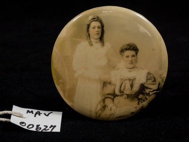
Photograph, small circular frame c1900, c1900
A photograph of 2 women c 1900 members of the Curtis family who were early settlers in Moorabbin ShireThe family of May Curtis were early settlers in Moorabbin ShireA black and white photograph of 2 unnamed women in a small circular frame with a wire support stand c 1900nilmoorabbin, cheltenham, bentleigh, early settlers, photographs, curtis may -
 City of Moorabbin Historical Society (Operating the Box Cottage Museum)
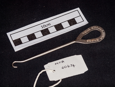
Clothing, button hook, c1900
A button hook is a tool used for the closing of shoes, gloves or other apparel that uses buttons as fasteners. It consists of a steel hook fixed to a handle which may be simple or decorative. The hook end is inserted through the buttonhole to capture the button by the shank and draw it through the opening. Many were distributed as advertising for a Company, as this is for 'Ezywalkin' footwearWalter David Cookes established the Ezywalkin Shoe Company Pty Ltd in 1901 in Fremantle Western Australia. The Melbourne factory was established in 1910A steel, button hook for shoes and gaiterson handle 'WEAR EZYWALKIN'S SHOES 'clothing, footwear, gaiters, boots, ezywalkin footwear, cookes walter david, company ltd, craftwork, moorabbin, brighton, early settlers, pioneers, cheltenham -
 City of Moorabbin Historical Society (Operating the Box Cottage Museum)
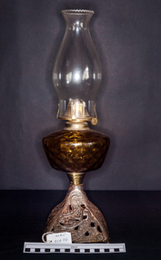
Lights, Victorian kerosene banquet lamp, c1900
The kerosene lamp is a type of lighting device that uses kerosene as a fuel. Kerosene lamps have a wick or mantle as light source, protected by a glass chimney or globe; lamps may be used on a table, or hand-held lanterns may used for portable lighting. There are three types of kerosene lamp: traditional flat wick, central draught (tubular round wick), and mantle lamp. The screws on the side adjust the flame and hence the strength of the flame produced. Prior to the introduction of gas and electricity these lamps provided lighting in all householdsPioneers and early settlers in Moorabbin Shire relied on kerosene lamps for lighting their homes after sunset.This kerosene, flat wick, banquet lamp has a clear glass shade chimney with a frilled rim, a reservoir of plain yellow glass and a metal engraved base . 1 side screw to adjust the flamelights, early settlers, pioneers, market gardeners, moorabbin, brighton, bentleigh, cheltenham. lamps, kerosene, paraffin, oil