Showing 414 items matching "north kew"
-
 Kew Historical Society Inc
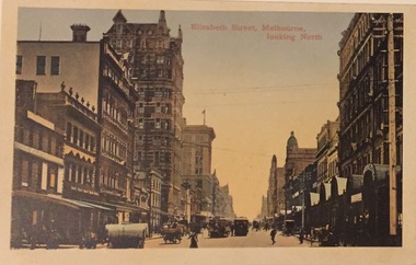
Postcard, Elizabeth Street, Melbourne, Looking North, 1920-1940
Collection of thirty-nine postcards donated by Jillian Rigby which had been owned by her grandparents, George and Edith Weir, who from c.1917 lived at 84 Princess Street, Kew. The mostly 'mint' postcards were purchased in Victoria and while travelling overseas. The sole dated postcard is dated from 1929. The postcards are numbered sequentially from 2017.0058.01-39. The remainder of the collection donated by Jill Rigby which was once owned by the Weirs of Broken Hill and Kew consist of costumes, costume accessories, photographs, and documents.The postcards in the Weir collection, especially those purchased on a trip or trips to the mother country, i.e. United Kingdom, represent a representative sample of sites that were considered significant to those Australians undertaking a reverse grand tour by member of the erstwhile colonies. Those postcards which are early views of Melbourne must have been produced commercially for some decades from the early part of the 20th century.Elizabeth Street, Melbourne, looking north. Coloured postcard. Weir collection."Kew Historical Society Inc"postcards, george and edith weir, elizabeth street - melbourne, weir collection -
 Kew Historical Society Inc
Plan, Melbourne & Metropolitan Board of Works : Borough of Kew : Detail Plan No.1350, 1910
The Melbourne and Metropolitan Board of Works (MMBW) plans were produced from the 1890s to the 1950s. They were crucial to the design and development of Melbourne's sewerage and drainage system. The plans, at a scale of 40 feet to 1 inch (1:480), provide a detailed historical record of Melbourne streetscapes and environmental features. Each plan covers one or two street blocks (roughly six streets), showing details of buildings, including garden layouts and ownership boundaries, and features such as laneways, drains, bridges, parks, municipal boundaries and other prominent landmarks as they existed at the time each plan was produced. (Source: State Library of Victoria). This plan forms part of a large group of MMBW plans and maps that was donated to the Society by the Mr Poulter, City Engineer of the City of Kew in 1989. Within this collection, thirty-five hand-coloured plans, backed with linen, are of statewide significance as they include annotations that provide details of construction materials used in buildings in the first decade of the 20th century as well as additional information about land ownership and usage. The copies in the Public Record Office Victoria and the State Library of Victoria are monochrome versions which do not denote building materials so that the maps in this collection are invaluable and unique tools for researchers and heritage consultants. A number of the plans are not held in the collection of the State Library of Victoria so they have the additional attribute of rarity.Original survey plan, issued by the MMBW to a contractor with responsibility for constructing sewers in the area identified on the plan within the Borough of Kew. The plan was at some stage hand-coloured, possibly by the contractor, but more likely by officers working in the Engineering Department of the Borough and later Town, then City of Kew. The hand-coloured sections of buildings on the plan were used to denote masonry or brick constructions (pink), weatherboard constructions (yellow), and public buildings (grey). MMBW Plan No. 1350 depicts the western end of Studley Park on the north side of the Studley Park Road. ‘Raheen’, then the home of Sir Henry Wrixon is named, the plan identifying those parts of the house that were built of brick and timber. The two houses between Raheen and the River Yarra are also shown. Other parts of the plan show neighbouring streets: Yarra Street, Studley Park Avenue, Studley Street and Fenwick Street. Each, apart from Fenwick Street was subsequently renamed. At the corner of Fenwick and Stawell Streets, the home of Joseph Butterworth Coombs, later called ‘Hope Mansell’, is represented but unnamed.melbourne and metropolitan board of works, detail plans, mmbw 1350, cartography -
 Kew Historical Society Inc
Plan, Melbourne & Metropolitan Board of Works : Borough of Kew : Detail Plan No.1572, 1905
The Melbourne and Metropolitan Board of Works (MMBW) plans were produced from the 1890s to the 1950s. They were crucial to the design and development of Melbourne's sewerage and drainage system. The plans, at a scale of 40 feet to 1 inch (1:480), provide a detailed historical record of Melbourne streetscapes and environmental features. Each plan covers one or two street blocks (roughly six streets), showing details of buildings, including garden layouts and ownership boundaries, and features such as laneways, drains, bridges, parks, municipal boundaries and other prominent landmarks as they existed at the time each plan was produced. (Source: State Library of Victoria)This plan forms part of a large group of MMBW plans and maps that was donated to the Society by the Mr Poulter, City Engineer of the City of Kew in 1989. Within this collection, thirty-five hand-coloured plans, backed with linen, are of statewide significance as they include annotations that provide details of construction materials used in buildings in the first decade of the 20th century as well as additional information about land ownership and usage. The copies in the Public Record Office Victoria and the State Library of Victoria are monochrome versions which do not denote building materials so that the maps in this collection are invaluable and unique tools for researchers and heritage consultants. A number of the plans are not held in the collection of the State Library of Victoria so they have the additional attribute of rarity.Original survey plan, issued by the MMBW to a contractor with responsibility for constructing sewers in the area identified on the plan within the Borough of Kew. The plan was at some stage hand-coloured, possibly by the contractor, but more likely by officers working in the Engineering Department of the Borough and later Town, then City of Kew. The hand-coloured sections of buildings on the plan were used to denote masonry or brick constructions (pink), weatherboard constructions (yellow), and public buildings (grey). Plan No. 1572 represents the built environment bordered by Barkers Road, Wrixon Street, Edgevale Road and Fitzwilliam Street. Other streets identified on the plan include Stansell Street. Plan 1572 shows that by 1903-05, there was only patchy development in this area of Kew, mainly on Edgevale Road and Fitzwilliam Street. Only two named houses are identified: the quaintly named ‘Tweed Cottage’, and ‘Mendip’. The earliest reference to Treed Cottage in Australian newspapers is to the death of Walter Thompson, aged 74 who was a resident there in 1885. His youngest daughter was to die there in 1908. Mendip to the north of Tweed Cottage was owned by Henry Thompson; he was to die in 1901; his wife in 1932. At this period of time, Malin Street and Clivedon Court did not extend to Barkers Road.melbourne and metropolitan board of works, detail plans, mmbw 1572, cartography -
 Kew Historical Society Inc
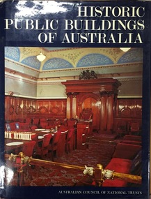
Book, Cassel Australia, Historic Public Buildings of Australia, 1971
[North Melbourne] : Cassell Australia, [1971] 306 pages : illustrations (some colour) ; 32 cm. non-fictionpublic buildings -- australia. -
 Kew Historical Society Inc
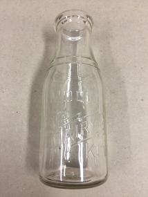
Container, Model Dairy, Milk Bottle, Twentieth Century
The Model Dairy was founded by the Kew pioneer, James Venn Morgan. The dairy had a number of different locations in Kew depending on the time period. Its final incarnation was on the north side of Cotham Road, between Ridgeway Avenue and Kent Street, Kew. The final factory was designed by the architects Bates, Smart and McCutcheon.Kew was a major milk producing district in the Nineteenth and early Twentieth centuries, with three major dairy farms lining the Yarra between Studley Park in the west and Burke Road in the east. In addition to these dairy producers, there were also a number of accredited dairy retailers in the suburb. The largest and most enduring of these was the Model Dairy founded by the Kew pioneer James Venn Morgan. Milk bottles that include the name of the producer or retailer are historically significant as they represent a period in Kew's history before the mass production of milk in the second half of the Twentieth Century. A number of these named bottles have the additional attribute of rarity.Milk bottle - Model Dairy Kew. Pressed inscription: "Model Dairy Ltd Kew." Reverse: " This bottle contains milk bottled for sale by Model Dairey Ltd and always remains their property. It is loaned & cannot legally be used by others. One Imperial Pint. This bottle differs from 1981.0010 in that it has two pressed rings on the neck of the bottle.milk bottles, model dairy (kew) -
 Kew Historical Society Inc
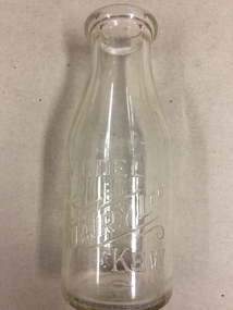
Container, Model Dairy, Milk Bottle, Twentieth Century
The Model Dairy was founded by the Kew pioneer, James Venn Morgan. The dairy had a number of different locations in Kew depending on the time period. Its final location was on the north side of Cotham Road, Kew between Ridgeway Avenue and Kent Street. Its final factory was designed by the architects Bates, Smart and McCutcheon.Kew was a major milk producing district in the Nineteenth and early Twentieth centuries, with three major dairy farms lining the Yarra between Studley Park in the west and Burke Road in the east. In addition to these dairy producers, there were also a number of accredited dairy retailers in the suburb. The largest and most enduring of these was the Model Dairy founded by the Kew pioneer James Venn Morgan. Milk bottles that include the name of the producer or retailer are historically significant as they represent a period in Kew's history before the mass production of milk in the second half of the Twentieth Century. A number of these named bottles have the additional attribute of rarity.Milk bottle - Model Dairy Kew. Pressed inscription: "Model Dairy Ltd Kew." Reverse: " This bottle contains milk bottled for sale by Model Dairey Ltd and always remains their property. It is loaned & cannot legally be used by others. One Imperial Pint. This bottle differs from 1981.0009 in that it does not have two pressed rings on the neck of the bottle.milk bottles, model dairy (kew) -
 Kew Historical Society Inc
Photograph, Stuart Tompkins Studio, Electricity Supply Poles, Warrigal Road, Holmesglen, 1965
Research provided by Stuart Tompkins Studio, Box Hill, into alternatives for median strip street lighting to be used in Burke Road, Kew. The photographers identified variants in different suburbs appropriate to Kew's needs. The series from which the photograph is drawn provides a snapshot by a commercial photographic studio of each named vicinity in 1965 as well as providing examples of public works infrastructure being commissioned by local government in the 1960s. The photos originally formed part of the Engineering Department's files in the City of Kew before being donated to the kew Historical Society.Electricity Supply Poles, Warrigal Road, Holmesglen, 1965. Stuart Tompkins Studio provided this photograph for the Kew City Council. The photograph of Warrigal Road, north of Holmesglen looking north depicts wooden poles with bracket light fittings. These were the same as those proposed for Kew, except the lights and fittings were not to be 350 watt. Mercury lamps were preferred. [There are three copies of this photograph in the Collection.] Typed inscription on reverse: "Electricity Supply Poles. Photographed for Kew City Council 8/2/65. No.3 Warrigal Road - North of Holmesglen looking north. Wooden poles with bracket fittings same as those proposed for Kew except lights and fittings are not for 250 watt c. c. mercury lamps proposed. Wooden pole 3' up 11 3/4" dia." Studio stamp: "Stuart Tompkins Studio. 547 Station Street, Box Hill. WX1439."stuart tompkins studio, warrigal road (holmesglen) 1965, street lighting -
 Kew Historical Society Inc
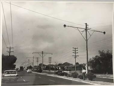
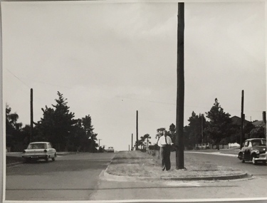
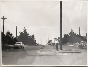
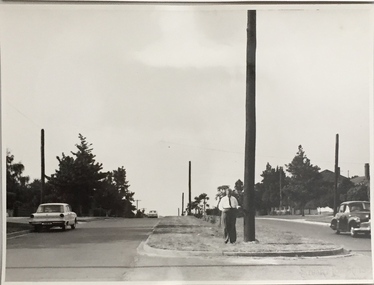
Photograph, Stuart Tompkins Studio, Electricity Supply Poles, North Road, Ormond, 1965
Research provided by Stuart Tompkins Studio, Box Hill, into alternatives for median strip street lighting to be used in Burke Road, Kew. The photographers identified variants in different suburbs appropriate to Kew's needs.The series from which the photograph is drawn provides a snapshot by a commercial photographic studio of each named vicinity in 1965 as well as providing examples of public works infrastructure being commissioned by local government in the 1960s. The photos originally formed part of the Engineering Department's files in the City of Kew before being donated to the kew Historical Society.Electricity Supply Poles, North Road, Ormond, 1965. Electricity supply poles photographed for the Kew City Council by Stuart Tompkins Studio. The photograph of North Road, Ormond west of Jasper Road, looking east depicts wooden poles carrying two lamps in a median strip and with two on each side alternately. It was noted that the supply wires were from one side only. The poles were described as 3′ above ground and 11.25″ in diameter. The plan was to use this approach for Burke Road, Kew. [There are three copies of this photograph in the Collection.] Typed inscription on reverse: "Electricity Supply Poles. Photographed for Kew City Council 8/2/65. No.1 North Road - Ormond, west of Jasper Road, looking east. Wooden poles carrying two lamps in median strip and two on each side alternately just as is proposed for Burke Road, Kew. Supply wires from one side only. Poles 3' above ground 11 1/4" dia." Studio stamp: "Stuart Tompkins Studio. 547 Station Street, Box Hill. WX1439."stuart tompkins studio, street lighting, south road (moorabin) 1965, public infrastructure -- city of kew, city of kew -- engineer's department -
 Kew Historical Society Inc
Photograph, Stuart Tompkins Studio, Electricity Supply Poles, North Road, Ormond, 1965
Research provided by Stuart Tompkins Studio, Box Hill, into alternatives for median strip street lighting to be used in Burke Road, Kew. The photographers identified variants in different suburbs appropriate to Kew's needs.The series from which the photograph is drawn provides a snapshot by a commercial photographic studio of each named vicinity in 1965 as well as providing examples of public works infrastructure being commissioned by local government in the 1960s. The photos originally formed part of the Engineering Department's files in the City of Kew before being donated to the kew Historical Society.Electricity Supply Poles, North Road, Ormond, 1965. Electricity supply poles photographed for the Kew City Council by Stuart Tompkins Studio. The photograph of North Road, Ormond west of Jasper Road, looking east depicts wooden poles carrying two lamps in a median strip and with two on each side alternately. It was noted that the supply wires were from one side only. The poles were described as 3′ above ground and 11.25″ in diameter. The plan was to use this approach for Burke Road, Kew. [There are three copies of this photograph in the Collection.] Typed inscription on reverse: "Electricity Supply Poles. Photographed for Kew City Council 8/2/65. No.1 North Road - Ormond, west of Jasper Road, looking east. Wooden poles carrying two lamps in median strip and two on each side alternately just as is proposed for Burke Road, Kew. Supply wires from one side only. Poles 3' above ground 11 1/4" dia." Studio stamp: "Stuart Tompkins Studio. 547 Station Street, Box Hill. WX1439."stuart tompkins studio, street lighting, south road (moorabin) 1965 -
 Kew Historical Society Inc
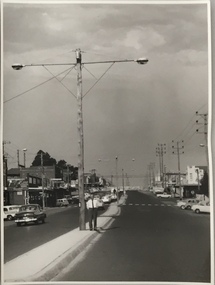
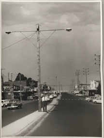
Photograph, Stuart Tompkins Studio, Electricity Supply Poles, Burke Road, Kew, 1965
... . This photograph of Burke Road, Kew was taken just north of Kilby.... Photographed for Kew City Council 8/2/65. No.5 Burke Road - Kew, just.... No.5 Burke Road - Kew, just north of Kilby and Doncaster Roads ...Research provided by Stuart Tompkins Studio, Box Hill, into alternatives for median strip street lighting to be used in Burke Road, Kew. The photographers identified variants in different suburbs appropriate to Kew's needs.The series from which the photograph is drawn provides a snapshot by a commercial photographic studio of each named vicinity in 1965 as well as providing examples of public works infrastructure being commissioned by local government in the 1960s. The photos originally formed part of the Engineering Department's files in the City of Kew before being donated to the kew Historical Society.Electricity Supply Poles, Burke Road, Kew, 1965. This photograph of Burke Road, Kew was taken just north of Kilby and Doncaster Roads looking north. Stuart Tompkins Studio provided the photograph for the Kew City Council. In the photograph are a number of electricity supply poles that have been erected in the median strip, in addition to some new poles on each footpath. The nearest wooden pole is stated to be 13.5″ in diameter. The electricity poles in Burke Road required Kew Council to investigate comparable designs in other Melbourne municipalities. [There are three copies of this photograph in the Collection.] Typed inscription on reverse: "Electricity Supply Poles. Photographed for Kew City Council 8/2/65. No.5 Burke Road - Kew, just north of Kilby and Doncaster Roads looking north. Some of seven poles already erected in median strip. Shows also some new poles erected on each footpath. Nearest wooden pole 13 1/2" dia." Studio stamp: "Stuart Tompkins Studio. 547 Station Street, Box Hill. WX1439."stuart tompkins studio, street lighting, south road (moorabin) 1965 -
 Kew Historical Society Inc
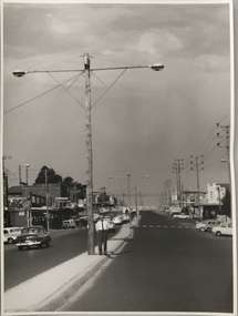
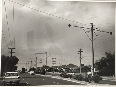
Photograph, Stuart Tompkins Studio, Electricity Supply Poles, Warrigal Road, Ashwood, 1965
Research provided by Stuart Tompkins Studio, Box Hill, into alternatives for median strip street lighting to be used in Burke Road, Kew. The photographers identified variants in different suburbs appropriate to Kew's needs.The series from which the photograph is drawn provides a snapshot by a commercial photographic studio of each named vicinity in 1965 as well as providing examples of public works infrastructure being commissioned by local government in the 1960s. The photos originally formed part of the Engineering Department's files in the City of Kew before being donated to the kew Historical Society.Electricity Supply Poles, Warrigal Road, Ashwood, 1965. Stuart Tompkins Studio provided this photograph for the Kew City Council. The photograph, taken at the intersection of Warrigal Road and High Street South, Ashwood looks north along High Street Road. The intent of the photograph was to provide the Council with models of electricity supply poles. In the photo, wooden and steel poles can be seen in the median strip. The photograph also includes the shops bordering High Street Road during this period. [There are three copies of this photograph in the Collection.]. Typed inscription on reverse: "Electricity Supply Poles. Photographed for Kew City Council 8/2/65. No.4 Warrigal Road - Ashwood. South of High Street Road looking north. Wooden and steel poles with different brackets in median strip." Studio stamp: "Stuart Tompkins Studio. 547 Station Street, Box Hill. WX1439."electric light poles, public works -- 1960s, civic infrastructure -- 1960s -
 Kew Historical Society Inc
Photograph, Stuart Tompkins Studio, Electricity Supply Poles, Warrigal Road, Ashwood, 1965
Research provided by Stuart Tompkins Studio, Box Hill, into alternatives for median strip street lighting to be used in Burke Road, Kew. The photographers identified variants in different suburbs appropriate to Kew's needs.The series from which the photograph is drawn provides a snapshot by a commercial photographic studio of each named vicinity in 1965 as well as providing examples of public works infrastructure being commissioned by local government in the 1960s. The photos originally formed part of the Engineering Department's files in the City of Kew before being donated to the kew Historical Society.Electricity Supply Poles, Warrigal Road, Ashwood, 1965. Stuart Tompkins Studio provided this photograph for the Kew City Council. The photograph, taken at the intersection of Warrigal Road and High Street South, Ashwood looks north along High Street Road. The intent of the photograph was to provide the Council with models of electricity supply poles. In the photo, wooden and steel poles can be seen in the median strip. The photograph also includes the shops bordering High Street Road during this period. [There are three copies of this photograph in the Collection.]. Typed inscription on reverse: "Electricity Supply Poles. Photographed for Kew City Council 8/2/65. No.4 Warrigal Road - Ashwood. South of High Street Road looking north. Wooden and steel poles with different brackets in median strip." Studio stamp: "Stuart Tompkins Studio. 547 Station Street, Box Hill. WX1439."electric light poles, civic infrastructure - 1960s, public works -- 1960s -
 Kew Historical Society Inc
Photograph, Stuart Tompkins Studio, Electricity Supply Poles, Warrigal Road, Ashwood, 1965
Research provided by Stuart Tompkins Studio, Box Hill, into alternatives for median strip street lighting to be used in Burke Road, Kew. The photographers identified variants in different suburbs appropriate to Kew's needs.The series from which the photograph is drawn provides a snapshot by a commercial photographic studio of each named vicinity in 1965 as well as providing examples of public works infrastructure being commissioned by local government in the 1960s. The photos originally formed part of the Engineering Department's files in the City of Kew before being donated to the kew Historical Society.Electricity Supply Poles, Warrigal Road, Ashwood, 1965. Stuart Tompkins Studio provided this photograph for the Kew City Council. The photograph, taken at the intersection of Warrigal Road and High Street South, Ashwood looks north along High Street Road. The intent of the photograph was to provide the Council with models of electricity supply poles. In the photo, wooden and steel poles can be seen in the median strip. The photograph also includes the shops bordering High Street Road during this period. [There are three copies of this photograph in the Collection.]. Typed inscription on reverse: "Electricity Supply Poles. Photographed for Kew City Council 8/2/65. No.4 Warrigal Road - Ashwood. South of High Street Road looking north. Wooden and steel poles with different brackets in median strip." Studio stamp: "Stuart Tompkins Studio. 547 Station Street, Box Hill. WX1439."electric light poles, public infrastructure -- 1960s, civic works -- 1960s -
 Kew Historical Society Inc
Journal, Kew Historical Society, Newsletter No.132, September 2020
There once was a creek [Connors Creek] / Julie King p1. History news [Coronavirus (COVID-19), Michael Tuck grandstand, grants,] p3. The men who bought Kew: the Fenwicks and Edward Bell / David White p4. The Henty Garden at Tarring: Ruyton Girls’ School / Felicity Renowden p6. Paddocks, parks and bye-laws: regulating behaviours by and within municipalities / Robert Baker p8. A significant donation [Margaret Picken’s property illustrations] / Robert Baker p10. From the collection [North Indian scarf embroidered with a needle] / Robert Baker p10. The albums of Eva Grant: photographs and descriptions of historic houses / Robert Baker p11.Published quarterly since 1977, the newsletters of the Kew Historical Society contain significant research by members exploring relevant aspects of the Victorian and Australian Framework of Historical Themes. Frequently, articles on people, places and artefacts are the only source of information about an aspect of Kew, and Melbourne’s history.non-fictionThere once was a creek [Connors Creek] / Julie King p1. History news [Coronavirus (COVID-19), Michael Tuck grandstand, grants,] p3. The men who bought Kew: the Fenwicks and Edward Bell / David White p4. The Henty Garden at Tarring: Ruyton Girls’ School / Felicity Renowden p6. Paddocks, parks and bye-laws: regulating behaviours by and within municipalities / Robert Baker p8. A significant donation [Margaret Picken’s property illustrations] / Robert Baker p10. From the collection [North Indian scarf embroidered with a needle] / Robert Baker p10. The albums of Eva Grant: photographs and descriptions of historic houses / Robert Baker p11.kew historical society (vic.) -- periodicals., kew historical society (vic.) -- newsletters, kew historical society (vic.) -- journals -
 Kew Historical Society Inc
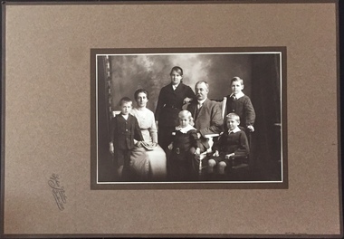
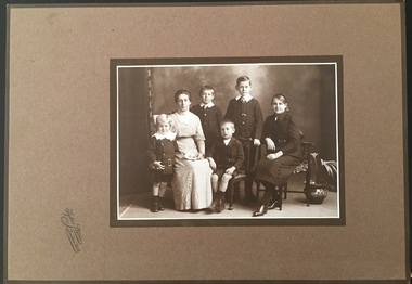
Photograph - The Weir family of Broken Hill, Sykes Studio, c.1914
An item forming part of a collection of costumes, photographs and documents relating to the Weir family who lived in the mansion originally named Illapa, 84 Princess Street, Kew, from c.1917 to 1950. This historically significant collection includes items relating to both George Weir (1866-1937) and his wife Edith Mary Weir (1867-1948). George Weir attained national prominence in the mining industry, becoming General Manager of the North Broken Hill Silver Mining Company in 1903 (later renamed North Broken Hill Mining Company 1905-12, and North Broken Hill Ltd 1912-1988), and subsequently President of the Mine Owners Association. He was to remain General Manager of North Broken Hill Ltd until his retirement in 1926.Important group family photograph, taken in Broken Hill, of the two Weir parents and their children. Another aspect of the photograph is that it is revealing about fashion and the tastes of the period.Studio portrait of George and Edith Weir and their five children, taken by a photographer of the Sykes Studio in Broken Hill, New South Wales. The members of the family are from left to right: Cecil Rigby Weir (1904-1983), Edith Mary Weir (nee Betteridge) (1867-1948), Edith Rigby Weir (1899-1981), John Rigby Weir (1910-1971), George Weir (1866-1937), Horace Rigby Weir (1907-1988), and George Rigby Weir (1901-1927). [John Rigby Weir was the father of the donor]weir collection, george weir, horace rigby weir, george rigby weir, john rigby weir, edith rigby weir, edith mary weir (nee betteridge), sykes studio -- broken hill -
 Kew Historical Society Inc
Photograph - The Weir family of Broken Hill, Sykes Studio, c.1914
An item forming part of a collection of costumes, photographs and documents relating to the Weir family who lived in the mansion originally named Illapa, 84 Princess Street, Kew, from c.1917 to 1950. This historically significant collection includes items relating to both George Weir (1866-1937) and his wife Edith Mary Weir (1867-1948). George Weir attained national prominence in the mining industry, becoming General Manager of the North Broken Hill Silver Mining Company in 1903 (later renamed North Broken Hill Mining Company 1905-12, and North Broken Hill Ltd 1912-1988), and subsequently President of the Mine Owners Association. He was to remain General Manager of North Broken Hill Ltd until his retirement in 1926.Important group family photograph, taken in Broken Hill, of Edith Mary Weir and her children. Another aspect of the photograph is that it is revealing about fashion and the tastes of the period.Studio portrait of Edith Mary Weir and her five children, taken by a photographer of the Sykes Studio in Broken Hill, New South Wales. The members of the family are from left to right: John Rigby Weir (1910-1971), Edith Mary Weir (nee Betteridge), Cecil Rigby Weir (1904-1983), Horace Rigby Weir (1907-1988), George Rigby Weir (1901-1927), and Edith Rigby Weir (1899-1981). [John Rigby Weir was the donor's father].Stykes Studio / Broken Hillweir collection, george weir, horace rigby weir, george rigby weir, john rigby weir, edith rigby weir, edith mary weir (nee betteridge), sykes studio -- broken hill -
 Kew Historical Society Inc
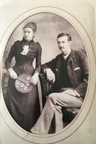
Photograph - George and Edith Weir, Yeomans Studio, 1891
An item forming part of a collection of costumes, photographs and documents relating to the Weir family who lived in the mansion originally named Illapa, 84 Princess Street, Kew, from c.1917 to 1950. This historically significant collection includes items relating to both George Weir (1866-1937) and his wife Edith Mary Weir (1867-1948). George Weir attained national prominence in the mining industry, becoming General Manager of the North Broken Hill Silver Mining Company in 1903 (later renamed North Broken Hill Mining Company 1905-12, and North Broken Hill Ltd 1912-1988), and subsequently President of the Mine Owners Association. He was to remain General Manager of North Broken Hill Ltd until his retirement in 1926.An early studio portrait of Edith Mary Weir (nee Betteridge) & George Weir c. 18/11/1891. The family story is that the photograph was taken by Yeomen photographers, of Burke St East, Melbourne about the time of their wedding prior to sailing on a ketch to Strachan, Tasmania.Print copy of an oval studio portrait of George Weir and Edith Mary Betteridge. In the portrait, George is seated while Edith stands to his right, holding a cockade fan.weir collection, george weir, horace rigby weir, george rigby weir, john rigby weir, edith rigby weir, edith mary weir (nee betteridge) -
 Kew Historical Society Inc
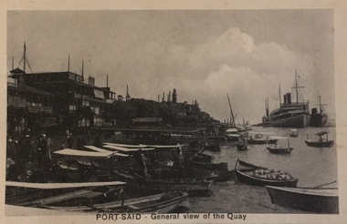
Postcard, The Cairo Postcard Trust, Port Said – General View of the Quay, c.1918
One of a number of 'real photo' and commercial postcards created by or owned by members of the Christian and Washfold families of Kew. The postcards are part of a larger collection of photographs, postcards and publications donated to the collection in May 2021.Sepia postcard of quay at Port Said, located on the north east coast of Egypt on the Mediterranean Sea, showing buildings and boats at left and two ocean liners at rightwashfold family, christian family, postcards -- port said, christian-washfold family -
 Kew Historical Society Inc
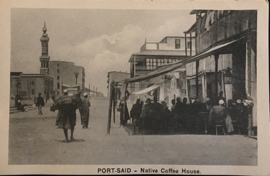
Postcard, The Cairo Postcard Trust, Port Said - Native Coffee House, c.1918
One of a number of 'real photo' and commercial postcards created by or owned by members of the Christian and Washfold families of Kew. The postcards are part of a larger collection of photographs, postcards and publications donated to the collection in May 2021.Sepia postcard of Port Said, located on the north east coast of Egypt on the Mediterranean Sea, showing mosque and minaret at left and coffee house in foreground at right.The Caro Postcard Trust Cairo 959 / Serie 632washfold family, christian family, postcards -- port said, christian-washfold collection -
 Kew Historical Society Inc
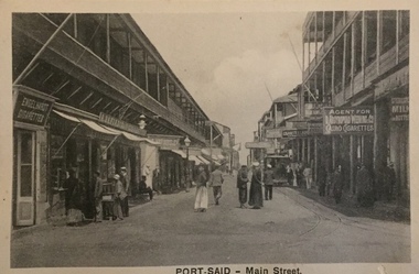
Postcard, The Cairo Postcard Trust, Port Said - Main Street, c.1918
One of a number of 'real photo' and commercial postcards created by or owned by members of the Christian and Washfold families of Kew. The postcards are part of a larger collection of photographs, postcards and publications donated to the collection in May 2021.Sepia postcard of main street in Port Said, located on the north east coast of Egypt on the Mediterranean Sea, showing buildings and stalls lining street.The Cairo Postcard Trust Cairo 953 / Serle 832washfold family, christian family, postcards -- port said, christian-washfold collection -
 Kew Historical Society Inc
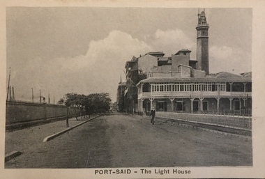
Postcard, The Cairo Postcard Trust, Port-Said - The Lighthouse, c.1918
One of a number of 'real photo' and commercial postcards created by or owned by members of the Christian and Washfold families of Kew. The postcards are part of a larger collection of photographs, postcards and publications donated to the collection in May 2021.Sepia postcard of Lighthouse at Port Said, located on the north east coast of Egypt on the Mediterranean Sea.The Cairo Postcard Trust Cairo 957 / Serle 632washfold family, postcards -- port said, christian family, christian-washfold collection -
 Kew Historical Society Inc
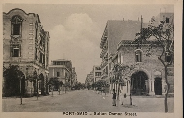
Postcard, The Cairo Postcard Trust, Port Said - Sultan Osman Street, c.1918
One of a number of 'real photo' and commercial postcards created by or owned by members of the Christian and Washfold families of Kew. The postcards are part of a larger collection of photographs, postcards and publications donated to the collection in May 2021.Sepia postcard of quay at Port Said, located on the north east coast of Egypt on the Mediterranean Sea, showing buildings lining Sultan Osman StreetThe Cairo Postcard Trust Cairo 962 / Serle 632washfold family, christian family, postcards -- port said, christian-washfold collection -
 Kew Historical Society Inc
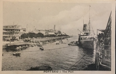
Postcard, The Cairo Postcard Trust, Port Said - The Port, c.1918
One of a number of 'real photo' and commercial postcards created by or owned by members of the Christian and Washfold families of Kew. The postcards are part of a larger collection of photographs, postcards and publications donated to the collection in May 2021.Sepia postcard of the Port at Port Said, located on the north east coast of Egypt on the Mediterranean Sea, showing buildings including the Savoy Hotel and boats at left and ocean liner at rightThe Cairo Postcard Trust Cairo 949. Serie 632christian-washfold collection, postcards -- port said (egypt) -
 Kew Historical Society Inc
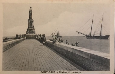
Postcard, The Cairo Postcard Trust, Port Said - Statue of Lesseps, c.1918
One of a series of postcards of Port Said, probably purchased at the end of the First World War and brought back to Australia by a member of the Christian or Washfold Families.Sepia postcard of quay at Port Said, located on the north east coast of Egypt on the Mediterranean Sea, showing statue of Lesseps, dhow and schooner. The Cairo Postcard Trust Cairo 956 / Serle 632washfold family, port said - postcards, statue of lesseps, postcards - port said, christian-washfold collection, wwi -
 Kew Historical Society Inc
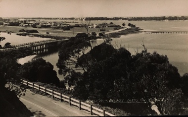
Photograph - North Arm Bridge, Lakes Entrance, Henry Beater Christian, 1920s
Henry Christian (c.1809-91) was one of the first settlers in Kew. He arrived in Victoria with his wife Agnes and son Orlando in 1855 on the Gypsy Queen. He established a rope-making business in Bulleen Road by 1858 but was declared insolvent two years later. In his final years, he was celebrated as one of the oldest living settlers of the district. His son, Orlando Henry Beater Christian (c.1853-1930) became a member of the Hawthorn Band and a foundation member of the Willsmere Swimming Club. Orlando and his wife Elizabeth had four children: Henry Beater (1886-1962), Ada Susannah May (1888-1962), Orlando Julius (1891-1917) and Lilian Adelaide ( -1956). Ada was to marry into the Washfold family. An item from an outstanding and diverse photographic collection, assembled by members of the Christian and Washfold families of Kew, comprising professional and amateur photography, depicting individuals, natural and settled environments and the interactions between these worlds. Photograph of Lake Arm Bridge at Lakes Entrance.Sent to Mavis and the boys [detailed text]landscape photography, lakes entrance (vic.), christian-washfold collection -
 Kew Historical Society Inc
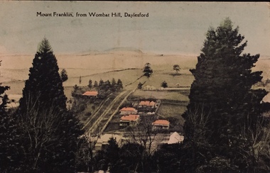
Postcard, Mount Franklin From Wombat Hill, Daylesford
One of a number of 'real photo' and commercial postcards created by or owned by members of the Christian and Washfold families of Kew. The postcards are part of a larger collection of photographs, postcards and publications donated to the collection in May 2021.Coloured postcard looking north from Daylesford to Mt Franklin.mt franklin, wombat hill, daylesford, postcards, landscape photography, christian-washfold collection