Showing 1809 items matching "planning and development"
-
 Glen Eira City Council History and Heritage Collection
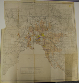
Map - Map, zoning, Metropolitan Town Planning Commission, "DISTRIBUTION AND USE OF EXISTING PROPERTY. MAP NO. 6.", 1929
... Metropolitan Town Planning Commission ...The map titled: “Distribution and use of Existing property map No. 6” (Metropolitan Town Planning Commission Melbourne and Suburbs) is of historical significance. It is listed on page 168 of Chapter 4 the Zoning section of the "Plan of General Development Melbourne Report of the Metropolitan Town Planning Commission 1929" - Melbourne's first strategic plan. Map No. 6 is mentioned throughout Chapter 4 of the 1929 Report. It states on page 156 that this Map was created to graphically illustrate the data collected by the Planning Commission. The Map illustrates the general distribution of uses of existing property throughout the metropolitan area. The coloured sections show the areas which were developed or were in the process of development in 1929. The colours indicate the distribution of uses in the developed areas. The pink coloured areas, which include Caulfield, were almost completely residential.1929, metropolitan town planning commission, melbourne, suburbs -
 Bialik College
Plan (item) - Site development proposals, Shakespeare Grove, 1986
Site development proposals for 6 Shakespeare Grove, Hawthorn, as part of the Bialik College Strategy Plan, created by Jennings Project Management, October 1986. Includes plan of existing land use and site constraints. Please contact [email protected] to request access to this record.1980s, building and planning -
 Kew Historical Society Inc
Plan, Melbourne & Metropolitan Board of Works : Contour Plan of Melbourne & Suburbs : Melbourne Sewage, 1894
The Melbourne and Metropolitan Board of Works (MMBW) plans were produced from the 1890s to the 1950s. They were crucial to the design and development of Melbourne's sewerage and drainage system. This plan forms part of a large group of MMBW plans and maps that was donated to the Society by the Mr Poulter, City Engineer of the City of Kew in 1989. Within this collection, thirty-five hand-coloured plans, backed with linen, are of statewide significance as they include annotations that provide details of construction materials used in buildings in the first decade of the 20th century as well as additional information about land ownership and usage. The copies in the Public Record Office Victoria and the State Library of Victoria are monochrome versions which do not denote building materials so that the maps in this collection are invaluable and unique tools for researchers and heritage consultants. A number of the plans are not held in the collection of the State Library of Victoria so they have the additional attribute of rarity.Digital copy of an original MMBW plan. This contour plan shows the area identified by the MMBW for purposes of drainage and sewerage in 1894. The suburbs represented extend from Williamstown in the west to Bulleen in the east, and from Preston in the north, south to Sandringham. Suburbs are outlined in coloured ink. Red lines indicate main and branch sewers in existence at the beginning of 1894 in central and inner Melbourne. These extended as far as Williamstown and Brighton, but not yet as far as Kew, where sewering did not commence until 1901. Contour lines show the topography, which was important for indicating the fall of the land for the laying of sewers and drainage channels. Kew appears to be fairly undeveloped at this date except for railway lines and stations (the Kew and Outer Circle lines), main roads, the Kew Lunatic Asylum Reserve and Studley Park. However, the contour plan does not accurately represent the density of settlement, nor the large number of houses, which were being built in Kew and other suburbs from the 1850s to the land boom of the late 1880’s and early 1890’s. This plan is part of a large and historically significant group of MMBW plans and maps that was donated to the Society by the Mr Poulter, City Engineer of the City of Kew in 1989.mmbw contour plan of melbourne and suburbs, melbourne and metropolitan board of works, melbourne sewage, cartography -
 Eltham District Historical Society Inc
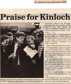
Drawing - Newspaper clipping, Praise for Kinloch, Diamond Valley News, April 8, 1998, p11, April 1998
PLANNING Minister Rob Maclellan and Nillumbik Shire president Robert Marshall have both praised an innovative housing development on a historic property east of Eltham's town centre. Both were present at the launch of the Kinloch Gardens development, where 12 new double and triple storey homes will be built along a private road in the gardens of Kinloch, a mansion set on 2.4ha in Arthur St. About 100 people attended the launch. Cr Marshall likened Kinloch Gardens to the Woodridge Estate at Eltham, which he said provided housing on small allotments while protecting much of the tree canopy, and "showed how a suburb can be built". He said Kinloch could easily have been subdivided, with a court running up the middle of the development, but the owners, the Jelbart family, opted instead for a private road on the property, sweeping around a common pond and 'village green'. ''This is a perfect example of what can be achieved in urban planning,'' he said. Mr Maclellan said the development was one of the most impressive he had seen in his role as Planning Minister Picture - Historic launch: Planning Minister Rob Maclellan (left) on a visit to Eltham last week to help launch a new housing development.Digital file only; created from scan undertaken by EDHS of item on loanarthur street, eltham, graeme gunn, houses, ian jelbart, jelbart property, kinloch gardens, rob maclellan, robert marshall, woodridge estate -
Port Melbourne Historical & Preservation Society
Plan - Montague Housing Development
COPYRIGHT PUBLIC RECORDS OFFICE Set of plans and documents relating to the State Savings bank, Montague Housing Development, in Gladstone St, Montague. This was an initiative of South Melbourne City Council to replace slum housing in Montague, 1935-40 .02 - 41 A4 pages including index, copies (some laminated)built environment - domestic, state savings bank of victoria -
Whitehorse Historical Society Inc.
Newspaper - Article, The Nunawading Post, Housing for low income people
Article in Nunawading Post. official opening of 12 room rooming house in Rooks Road, Nunawading on site of the previous Eastbridge Migrant hostel. The rooming house is just part of the multi-million dollar housing complex being developed by the Department of Planning and Development at Rooks Rd, it will be for low income single people.accommodation, outer east regional housing council, victoria. department of planning and development, atkinson, bruce, cameron, athol, baker, heather -
 Ballarat Tramway Museum
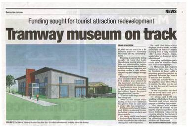
Newspaper, The Courier Ballarat, "Tramway museum on track" - "funding sought for tourist attraction development", 28/03/2014 12:00:00 AM
Newspaper clipping from The Courier, Friday 28/3/2014, page 7, titled "Tramway museum on track" - "funding sought for tourist attraction development", with an image of the Museums plan for the addition to the existing building. Includes information provided by Paul Mong, business case, creating jobs. Two copies collected.On front or rear of the cutting, information re dates etc.btm, museum -
 Robin Boyd Foundation
Document - Manuscript, Robin Boyd, (some people commit suicide …..)
Personal reflection of apartment tower developments in San Francisco - Golden Gateway Centre and Ghirardelli Square. A critique of their urban planning, particularly treatment of the ground plane and landscaping.Handwritten, quarto, 3 pages.apartment towers, urban planning, san francisco, golden gateway centre, ghirardelli square, robin boyd, manuscript -
 Greensborough Historical Society
Poster - Planning Document, Shire of Diamond Valley et al, Subdivision Plan # 1044 - Parish of Nillumbik, County Bourke, Crown Allotment B Section 12, Eltham North, 1981-1987
Subdivision Plan # 1044 - Parish of Nillumbik, County Bourke, Crown Allotment B Section 12, Eltham North. This subdivision plan includes Weidlich Road and St Clems Street. The developer for this subdivision is Taunton Developments and the Surveyors are Fisher Cleeland Turner & Dwyer Vic, Surveyors and Engineers.An example of hard copy subdivision plans from the Greensborough area. Mainly from the Shire of Diamond Valley era (1964-1994).Plan (single sided) mounted on heavy card. Stamped and handwritten Council permissions, dates and other details. subdivision plans, shire of diamond valley, taunton developments -
Ringwood and District Historical Society
Document, Packet: Five Ringwood Movie Club booklets with several newspaper clippings re cinema 1990s
Packet includes: . 5 copies of Ringwood Movie Club newsletter titled "Take One" dated 1979 onwards. . Several newspaper cuttings from the 1990's re plans for a cinema complex in Eastland, and the dispute between the proposal by Ringwood Multiplex Cinemas' development at the Ringwood Market site in Bond Street. -
Port Melbourne Historical & Preservation Society
Plan - Montague Housing Development
Provided to PMHPS by Steve Tserkezidis and follows on from his earlier materials on the Port Melbourne State Bank houses. See item 2824. Original source Public Records OfficeCOPYRIGHT PUBLIC RECORDS OFFICE Set of plans and documents relating to the State Savings bank, Montague Housing Development, in Gladstone St, Montague. This was an initiative of South Melbourne City Council to replace slum housing in Montague, 1935-40 .03 - 40 pages; .04 - 7 pages of A2 copies (some laminated)built environment - domestic, state savings bank of victoria -
 Kiewa Valley Historical Society
Plans - Southern Hydro - Bogong Power Development
Southern Hydro owned the Kiewa Hydro Electric Scheme in May 2006 when these plans were created. The Site No. 1 and Site No. 2 are part of the Bogong Power Development Bogong Power Development is part of the Kiewa Hydro Electric SchemeLaminated A3 plans mostly black and white but with a little color and surrounded by a grid.(Also see KVHS 1439) 1. Tunnel and Civil works / Commissioners Lodge Site Plan 1: Site No. 1 / TBN /Water /Supply / Reservoir Site 2. Tunnel and Civil Works / Pedestrian Diversion Access Paths / and Tracks: Site No. 2 / Lake Guy Site / Bogong Victoriabogong power development, southern hydro 2006 -
Canterbury History Group
Document - Plan fears, Progress Leader, February 18 2002
a letter to Editor on plan fears of development of "Shrublands". Includes a concise history and description of the early history of the property. The letter also signals intentio s to fight to save the property.Peter and Robin Adams of Balwyn Road, Canterbury, sparked a successful campaign to save Shrublands. See also #1071.shrublands, balwyn road, carter>ernest, vineyards, urban planning -
 Bacchus Marsh & District Historical Society
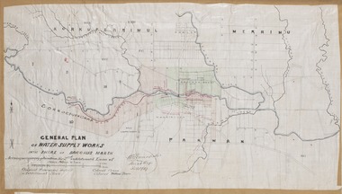
Map, General Plan for Water Supply Works, Shire of Bacchus Marsh 1887
Debate about water supply and its planning and development took place in the Bacchus Marsh region from the 1850s through into the twentieth century. This plan was part of documentation to support an application for an additional loan of money from the Ministry of Water Supply to the Bacchus Marsh Shire Water Supply Trust. The plan includes the route of a proposed water channel in the Parwan area, and other features of water supply infrastructure such as the location of standpipes and gates are also shown on the plan.A single page paper map showing a general plan for the supply of water in the Bacchus Marsh area.The plan shows the route of the 'Main Channel' near the Werribee River and a proposed route for a Parwan Channel. The location of 'Dryden's House' near the Werribee River is also shown and the locations of land held by T. (Tom) Oliver and the Racecourse Reserve in Maddingley. Scale 40 chains to 1 inch. The plan is signed by Bacchus Marsh Shire Engineer, W.E. Standfield. The map is pasted into a bound volume containing 76 maps or plans in total. High resolution digital image stored on BMDHS computer network. General Plan of Water Supply Works in the Shire of Bacchus Marsh. Accompanying application for 2nd additional Loan. Original Waterworks district. Additional area. W.E. Standfield, 30/8/87.water supply, water supply maps, water supply bacchus marsh, irrigation, bacchus marsh victoria maps -
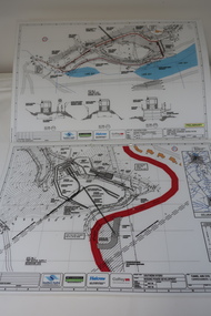
 Falls Creek Historical Society
Document - Proposed Chalet At Site 4
Bob (Herman) Hymans (a former member of the Royal Netherlands Navy) was born in Bloemendaal, Holland on 30th September 1922. During World War II he fought against the Japanese in the Dutch East Indies (now Indonesia) and was imprisoned in Changi and on the Burma Railway. After gaining qualifications as a Ski Instructor, Bob arrived in Falls Creek in July 1950. Working as an Instructor and Supervisor at Bogong Lodge, Bob decided his future was in accommodation. He was successful in negotiating an indenture for land from the State Electricity Commission (SEC). It took Bob two years to build his Grand Coeur Chalet but, tragically, it was burned down in August 1961. Bob also built the first Chairlift in Australia. This was a single chairlift and the structure was built from wooden electricity poles. He was constantly full of new ideas and proposals for the village. Bob Hymans died on 7th July 2007. This Collection of documents and letters tells the story of Bob's endeavours to develop Falls Creek into the ski village it is today.This item is significant because it documents proposals put forward by Bob Hymans to develop facilities in the Falls Creek Tourist Area.A letter from J. Dale Fisher, an architect acting on behalf of Mr Hymans. The letter accompanied plans submitted to the SEC and the Management Committee for approval of the development of SIte 4, Christie Street, Falls Creek. The plans had been modified in response to earlier concerns related to cost. The new chalet would provide accommodation and a swimming pool and stables. Mr Hymans aimed to build a chalet which operated year round and would rival any of the resorts in New South Wales.falls creek tourist area management committee, bob hymans, falls creek administration -
 Bendigo Historical Society Inc.
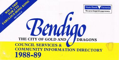
Book - BOOKLET: ''BENDIGO THE CITY OF GOLD AND DRAGONS'' (1988-89)
45 paged booklet - ''Bendigo - The City of Gold and Dragons'' (1988-89)- a Council services and community information directory. Contents : Mayor's message; City of Bendigo; Exciting current developments; Council meeting times; Your councillors; Corporate plan; Chief Executive Officer's message; Corporate Services Department; Rates and valuations; Revaluation; Tourism; Parking and traffic control; Dogs; By-laws; Community development; Library; Health and Human Services Department; Child Care centres; Home Care services; Leisure; Engineering and Technical Services Dept.; Town planning; Building; Parks and recreation; Shopping guide/car parking; Discount shopping vouchers; Operations Department; Street lighting; Garbage collection. Photographs of councillors and Departmental managers/directors.bendigo, council, community information directory, cr. r. adams, colin nankervis, michael currie, james douglass, phillip geri, rodney fyffe, jeffrey fyffe, peter morley, chris wilson. rates and valuations, parking, by laws, shopping. departmental managers and directors. -
 Bendigo Historical Society Inc.
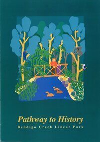
Pamphlet - MERLE HALL COLLECTION: ROSALIND PARK CREATIVE VILLAGE BENDIGO PROJECT PAMPHLET, 1993
MERLE HALL COLLECTION: ROSALIND PARK CREATIVE VILLAGE BENDIGO PROJECT PAMPHLET Pathway to History Bendigo Creek Linear Park Inside pages - Graphic image of the Linear Park from Alexandra Fountain to the Botanical Gardens, includes Rosalind Park, Golden Dragon Museum, Shamrock Hotel, Bendigo Gas Works, Chinese Joss House, Chinese Tea House, Lake Weroona, Wetlands, White Hill Cemetary and mine sites. On outside pages, cover, historical notes on Bendigo and Notes on the Bendigo Creek Linear Park. Notes on the back cover: A joint project of the City of Greater Bendigo and the Department of planning and development. Production by the Publick Affairs Branch, Department of Planning and Development. Printed in Bendigo June 1993 4360/93. -
 Melbourne Tram Museum
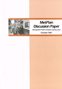
Document - Report, The Met, "MetPlan discussion Paper - Metropolitan Public Transport Industry Plan, Oct. 1987
Report or discussion paper, 76 pages printed on off white paper, with card cover, centre stapled, titled "MetPlan discussion Paper - Metropolitan Public Transport Industry Plan - October 1987". Prepared by Metropolitan Transit authority and Ministry of Transport, signed by the Kevin Shea as Managing Director the MTA. Has a summary of contents, table of contents, many figures and tables (see images 2 and 3). Looks at the current policies and objectives, Melbourne's urban development and public transport system, financial and staff picture, future public transport needs and planning the development of a future service. Gives details of book designers and printers on the last page. Second copy from donation of John Prideaux added 24-6-2016trams, tramways, metplan, minister for transport, public transport, the met, mta, melbourne -
Port Melbourne Historical & Preservation Society
Booklet, State Government of Victoria, Making the Most of the Bay, 1990
Making the Most of the Bay - Plan for the protection and development of Port Phillip and Corio Bays, November 1990. An A4 booklet considering environment, land use and settlement, recreation and tourism, coastal and marine industries. Detailed recommedations for specific areas and foreward by Ministers Steve Crabb and Andrew McCutcheon (ref. item 1414, draft version)state government victoria, natural environment - conservation -
 Port Melbourne Historical & Preservation Society
Badge - I am a friend of the park, Pat Grainger, 1987
Used at a 1987 community picnic and the Port Melbourne Festival 1988 after Vic.Govt. announced plans to create a "Boulevard" along the Railway in order to provide an upmarket approach to the Bayside Development.Large, pale pink badge "I am a friend of the park" from 1987 protest group against establishment of a major road along the railway reserve."Badge - A - Minit" and logo impressed on backpublic action campaigns, town planning - proposals shelved, town planning - proposals shelved - bayside, friends of the park -
 Greensborough Historical Society
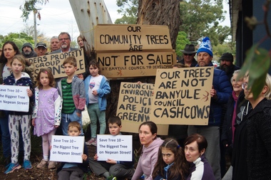
Photograph - Digital Image, Marilyn Smith, Diamond Valley Tree Protest 2019, 25/07/2019
A redevelopment of the Diamond Village area included a multi storey apartment block which required the removal of this tree (Tree 10) on the plans. A VCAT decision ruled that the development be no higher than 4 storeys, and a maximum of 15 dwellings. This photograph shows local residents protesting at the development and removal of tree in July 2019.Digital copy of colour photographdiamond village shopping centre, diamond village, nepean street watsonia -
 Greensborough Historical Society
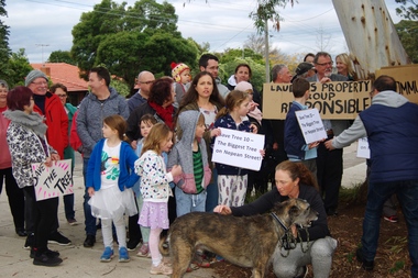
Photograph - Digital Image, Diamond Valley Tree Protest 2019 - people, 25/07/2019
A redevelopment of the Diamond Village area included a multi storey apartment block which required the removal of this tree (Tree 10) on the plans. A VCAT decision ruled that the development be no higher than 4 storeys, and a maximum of 15 dwellings. This photograph shows local residents protesting at the development and removal of tree in July 2019.Digital copy of colour photographsdiamond village shopping centre, diamond village, nepean street watsonia -
 Melbourne Legacy
Document - Minutes, Minutes of meeting of Steering Committee (Future of Residences)
Minutes of the meeting held on 20 June 1974 to discuss the in-depth study authorised by the Board of Management. Items considered included the development of plans, forward planning, and funding of the project to look at options for Blamey House, Stanhope and Harelands. See also Cat Nos. 01689 and 01690. Further investigations were called for. Gives an insight into Legacy thinking about the way in which the residences should be used.White foolscap photocopy, with black type. Two holes punched for filing. Double sided.Page 2: 'L/tee H.C.G. Rodgers' hand written in blue biro.residences, review, blamey house, harelands, stanhope -
 Bendigo Historical Society Inc.
Document - BENDIGO HERITAGE ADVISORY SERVICE: REPORT TO COUNCIL, JAN 1987
Bendigo Heritage Advisory Service - Report to Council, Jan 1987, This appears to be a draft report as there are handwritten changes on a number of pages. Report is set out in the form of an Introduction and a Summary. Advisory Service comprised Heritage Advisor, Andrew Ward; Bendigo and Eaglehawk Councils; National Trust; Bendigo Historical Society; MPE and Historic Buildings Council; community representatives??; City of Bendigo - Cr Rod Fyffe, Mr Norm Cameron. Recommendations - Changes to Planning Scheme; Policy encouraging reuse of Buildings; Adoption of Action Plans; Council to encourage Heritage based Tourism; Appropriate development applications encouraged. Attached are seven short papers on specific aspects of heritage planning - 1. a Statement of Bendigo's Significance; 2. The economic importance of heritage planning; 3. Planning Scheme heritage provisions; 4. Procedures for permits; 5. Action plans for Bendigo precincts; 6. Reuse of buildings; 7. Government incentives for heritage conservation., (this last one not attached as ''Already Circulated''.Bendigo Heritage Advisory Servicebendigo, council, heritage advisory committee, bendigo and eaglehawk councils. national trust, bendigo historical society, historic building council. reuse of buildings. -
 Greensborough Historical Society
Poster - Planning Document, Shire of Diamond Valley et al, Subdivision Plan # 1026 - Parish of Nillumbik, County Bourke, Crown Allotment B Section 12, Eltham North, 1981-1984
Subdivision Plan # 1026 - Parish of Nillumbik, County Bourke, Crown Allotment B Section 12, Eltham North. This subdivision plan includes Ryans Road (also known as Government Road) and St Clems Street. The developer for this subdivision is Taunton Developments and the Surveyors are Fisher Cleeland Turner & Dwyer Vic, Surveyors and Engineers.An example of hard copy subdivision plans from the Greensborough area. Mainly from the Shire of Diamond Valley era (1964-1994).Plan (single sided) mounted on heavy card. Stamped and handwritten Council permissions, dates and other details. subdivision plans, shire of diamond valley, taunton developments -
 Federation University Historical Collection
Book, Engineering: an illustrated weekly journal, 1884 (exact)
William Henry Maw was a British civil engineer and astronomer. He was born in 1838 and died in 1924 at eighty-five years. Maw worked as an assistant at the workshops of the Eastern Counties Railway before he became a draughtsman in the design office. He designed the first outside cylinder locomotive for use in India. In 1865 he founded the journal Engineering and continued to be an editor for the rest of his life. Maw became a consulting engineer. He was president of the Civil and Mechanical Engineers' Society, the Institution of Mechanical Engineers and the Institution of Civil Engineers. This book contains a wide range of articles and reviews related to industrial developments such as rail mill engines at the Dowlais iron works (constructed by Messrs. Kitson and Co., engineers, Leeds), cable tramway, Clay-street, San Francisco, U.S.A., road and railway bridge over the river Dnieper, at Jekaterinoslow, Russia (constructed from the designs of Professor N. Belelubsky, St. Petersburg, by the Brjonsk iron works) etc. A book with blue large hard cover. Title and publication date are written on spine in gold. Illustrations (fig., plates, plans, diagrams) in B/W. Includes collection of the engineering weekly journal vol. xxxix-from January to June 1885. This book contains a wide range of articles and reviews related to industrial developments. Page no.712.machinery, tools, engines, engineering, railroad, w h maw, rail, mill engines, cable tramway, clay street, dowlais iron works, twin screw engines, royal italian torpedo ram vessel, messrs r and, w hawthorn engineers, electro plated carriage, the tehuantepec ship railway, otis elevator -
 Bendigo Historical Society Inc.
Document - KANGAROO FLAT GOLD MINE COLLECTION: ENGINEERING FEASIBILITYY STUDY CENTRAL DEBORAH GOLD MINE
40 page engineering feasibility study, with plans, for the development of the Central Deborah Tourist Mine, prepared by John Connell-Mott, Hay and Anderson, Hatch, Jacobs, consulting engineers, dated February 20th 1981. Enlargement of the shaft, lift installation, ventilation, dewatering, electrical installation are discussed. Latest costings range from $689,000 to $790,000.bendigo, gold mining, central deborah gold mine -
University of Melbourne, Burnley Campus Archives
Plan, AMRAD Burnley Development Civil Drawings, 1997-1998
Job No 74046 New Laboratories & Offices Building 5 & 9 AMRAD Burnley Development, for AMRAD Operations Pty. Ltd. By Scott Wilson Irwin Johnston. (1) C1 Drawing Index, Legend & General Notes, Nov 97. (2) C2 Pavement & Drainage Plan 03.98. (3) C3 Pit Schedule & Pavement Details 03.98.scott wilson irwin johnston, amrad, johnston merat kurdiovsky architects, amrad burnley development -
 Bendigo Historical Society Inc.
Document - DOCUMENTS RELATING TO: THE BENDIGO AND DISTRICT TOURIST ASSOCIATION, July 7th, 1970
Various documents relating to the Bendigo and District Tourist Association. Includes Minutes of five meetings of the Board (1970/1971); Notice of AGM 1969; Annual Report 1971; Articles of Association (as amended 14/9/1971); single page headed ''Development of Nell Gwynne and Victoria Hill Sites'' - extensive plans for a 'tourist site with museum, cemetery, chapple (sic), rotunda. Theatre, façade of Charing Cross, a flying-fox from Nell Gwynne to Victoria Hill (no date); Mining Sub-Committee Report and Recommendation (Tourist Development Committee) 1967 re Resolution that ''Quartz Hill'' be developed as a mining tourist attraction (details provided ($75.000 est.); Draft Proposals for Brochure (authored by Miles Lewis, Carlton) - brochure to promote the idea of a museum and tourist development at the Nell Gwynne site; letter to Bendigo businesses re seeking funds for tourist development - Daryl McClure, Hon Sec June 1970.;bendigo, tourism, bendigo and district tourist association -
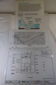 Kiewa Valley Historical Society
Plans - 2 Southern Hydro - Bogong Power Development and 1 Poster - Hydro-Electricity
Southern Hydro owned the Kiewa Hydro Electric Scheme in 2006. Southern Hydro owned the Kiewa Hydro Electric Scheme in 2006.Laminated A3 sheets The two Southern Hydro Bogong Power Development are black and white. 1. Tunnel and Civil Works / Power Station / Cross Section Sheet 4 of 6 Dated: June 2006 (Also see KVHS 1438) 2. Bogong Power / Development Waterway. Waterway Plan & Longsection / with Boreholes & Seismic Lines (Also see KVHS 1438) 3. Title: Hydro-Electricity in blue at the top and half-way down a blue and brown diagram titled 'Hydro-Electric Power Station'. At the bottom the title 'What is a watt?' southern hydro 2006, bogong power development