Showing 633 items matching "runs"
-
 RSL Victoria - Anzac House Reference Library and Memorabilia Collection
Diary of William John Stephenson
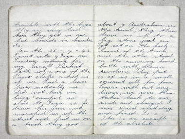
Stephenson departed Melbourne on 3 September 1941 onboard the Queen Mary. Diary runs from departure date until September 1 1942, covering Stephenson's Middle East service and his wounding in action at Alamein. One year later, Stephenson was wounded in action at Buiem River in New Guinea, and a few days later died from the wounds received.WW 2 diary of William Stephenson (VX 51713 2/23 Battalion).william john stephenson, ww11, 2/23 battalion, diaries -
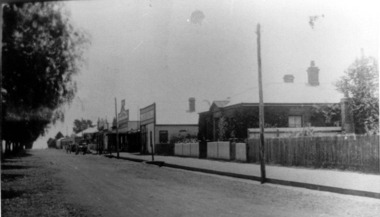
 Stawell Historical Society Inc
Photograph, Main Street Stawell looking West across Layzell Street intersection c 1900's
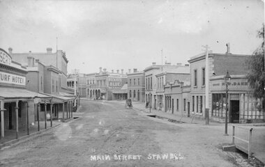
Main Street Stawell looking West across Layzell Street intersection. J Chadwick Drapers sign visible in centre of photo. Patrick Street runs off to the left of the photo behind wooden building the Foresters Hotel . Turf Hotel on left of photo. Horse drawn buggy near centre of photo. Circa 1900's. Similar to as 6730-2 & 0539PostcardMAIN STREET STAWELL - on front On Rear - Dear Viola. Another one of the Main Street. Rollo?stawell businesses streetscape -
 Brighton Historical Society
Dress, circa 1980
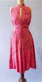
This dress belonged to Bayside woman Wendy Young, who bought it around 1980 from Melbourne designer Prue Acton's Toorak shop for about $300. She recalled, "It was one of her off the peg creations, but I never saw it on anyone else... she made limited runs, especially as this is hand painted silk." The belt has been signed by Acton.Sleeveless bias-cut dress of watermelon pink silk featuring red and gold hand-painted abstract designs. The dress features a Mandarin collar with a button fastening at the throat. A matching silk belt with tapered ties wraps around the waist.The belt features two signatures in gold paint: "Prue" and "P Acton"prue acton, 1980s, melbourne designers, wendy young -
 Bendigo Historical Society Inc.
Memorabilia - BENDIGO BUS WEEKLY TICKET, 1991
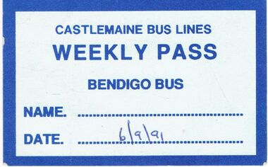
Alf Bentley (10907-1979) began an automotive business from his home in the 1930's. By the late '30's he had started a bus service and both businesses were operating from Forest Street. The business expanded to include all the school bus runs and in 1954 the name was changed from Bentley's Bus Lines to Castlemaine Bus Lines.Bendigo Bus Weekly Ticket: On light blue card with dark blue border and in blue print is * Castlemaine Bus Lines. Weekly Pass. Bendigo Bus. Name..... Date...6/9/91. Box 625transport, bus, bendigo bus, castlemaine bus lines. bendigo bus. -
![Scene on the River Campaspe / [by] Nicholas Caire, circa 1876](/media/collectors/550653872162f11fb04854aa/items/577b50b0d0cdd10948cb4cf6/item-media/577b51d2d0cdd10948cbedda/item-fit-380x285.jpg) Kew Historical Society Inc
Kew Historical Society IncPhotograph, Anglo-Australasian Photographic Company, Scene on the River Campaspe, c. 1876
Nicholas Caire was born on Guernsey in the Channel Islands in 1837. He arrived in Adelaide with his parents in about 1860. In 1867, following photographic journeys in Gippsland, he opened a studio in Adelaide. From 1870 to 1876 he lived and worked in Talbot in Central Victoria. In 1876 he purchased T. F. Chuck's studios in the Royal Arcade Melbourne. In 1885, following the introduction of dry plate photography, he began a series of landscape series, which were commercially successful. As a photographer, he travelled extensively through Victoria, photographing places few of his contemporaries had previously seen. He died in 1918. Reference: Jack Cato, 'Caire, Nicholas John (1837–1918)', Australian Dictionary of Biography.An original, rare photograph from the series 'Views of Victoria: General Series' by the photographer, Nicholas Caire (1837-1918). The series of 60 photographs that comprise the series was issued c. 1876 and reinforced a neo-Romantic view of the Australian landscape to which a growing nationalist movement would respond. Nicholas Caire was active as a photographer in Australia from 1858 until his death in 1918. His vision of the Australian bush and pioneer life had a counterpart in the works of Henry Lawson and other nationalist poets, authors and painters.Views of Victoria (General Series) No.25 / ‘Scene on the River Campaspe’ / Albumen silver photograph mounted on boardOn Reverse: ‘The River Campaspe flows into the River Murray, near the Town of Echuca. It is a river of considerable size, and is subject to frequent overflowing of its banks, in consequence of the low flat country through which it runs. Our illustration represents the River during one of the periodical floods, its depth being over thirty feet at the time.’nicholas caire (1837-1918), australia - landscape photography -
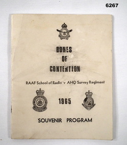 Bendigo Military Museum
Booklet - Bones of Contention Souvenir Program 1965, RAAF School of Radio, 1965
This is the program for the annual sports competition between the RAAF School of Radio, Laverton and the AHQ Survey Regiment, Bendigo. The location of the sports day alternated annually between the two units. The day major sports trophy was the "Large Bone Trophy" and the evening minor sports trophy was the "Little Bone Trophy".Booklet, B4 size, cream covered card, title, badges of RAAF School of Radio and Royal Australian Survey Corps, 30 pages, caricatures for each sport contested. The pages have been photographed and are stored on a USB Digital Storage Device. The 30 page images have been converted into a video (.mp4) format and are also stored on the USB. The video is 2.4Mb in size and runs for 5 minutes.Forward by Wing Commander E.R. Hall, Commanding Officer RAAF School of Radio.royal australian survey corps, rasvy, fortuna, army survey regiment, army svy regt, asr, raaf, raaf school of radio, bones day -
 Mortlake and District Historical Society
Bank of Victoria, Photograph
A branch of the Bank of Victoria was erected from bluestone in Mortlake in 1866. In 1860 improvements were made to the branch in in 1927 the Bank of Victoria mered with the Commercial Banking Co. of Sydney Ltd which later became the National Bank of Australia. This bluestone building was demolished in 1956 to make way for a new brick National Bank of Australia banking chamber and residence. The bluestone was taken to a local property called "Cattle Runs" -
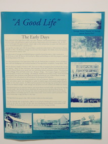 Kiewa Valley Historical Society
Posters - 9 in the Set, The Famous Bogong School, Beyond the Gate-(up and down) , A Good Life, The Precursors, Great Expectations, Windows to Yesterday, c1998
These posters were produced for a display during the Mt Beauty Music Festival in 1998. They cover the history of the Kiewa Valley from the early days, farming and the Kiewa Hydro Electric Scheme. These posters summarise the history of the Kiewa Valley and were compiled using memories, publications and documents. The posters are clear and useful for display.Large glossy cardboard posters: Mostly blue and white with photos and writing of the history of different aspects of the Kiewa Valley 1. Bogong School 2. Bogong Village 3. Mt Beauty 4. Tawonga 5. The Early Years 6. Kiewa Hydro Story 7. The Kiewa Valley Runs 8 & 9. Cattlemen & Huts of High Plains. Created for display with sources sighted. See KVHS 0956 bogong state school. bogong village. state electricity commission of victoria. tawonga. surveyors. mt beauty. camps. kiewa hydro electric scheme. kiewa valley. -
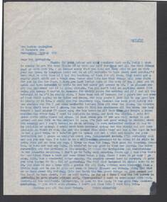 Bendigo Historical Society Inc.
Document - BILL ASHMAN COLLECTION: CORRESPONDENCE
Carbon copy of a typed letter to Mrs Marion Symington, dated 14/12/57. No signature oat the end. Writer mentions that he still runs the Scalebuoy Company, but business has been poor lately. He also mentions people owing money and a trip to Adelaide where he sold £500 there and since. He also mentions the lack of rain and growing plants without soil.sciences, instruments - general, scalebuoy, bill ashman collection - correspondence, mrs marion symington, scalebuoy company, hydroponics, prof gericke, california university -
 Victorian Aboriginal Corporation for Languages
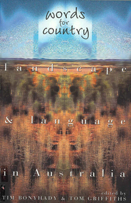
Book, Tim Bonyhady, Words for country : landscape &? language in Australia, 2002
Landscape and Language -- Lubra Creek -- The River Runs Backwards -- These Blarsted Hills -- Scarcely Any Water on Its Surface -- Everyone Who Has Ever Done A Tree Sit Always Says That The Tree Talks To You -- The Spirit of the Plains Kangaroo -- The Graveyard of a Century -- So Much for a Name -- Blackfellow Oven Roads -- The Ends of the Earth -- Natural Beauty, Man-Made -- Uluru -- The Outside Country -- It's Only Words.Mapslanguage and landscape, language essays, writing, storytelling -
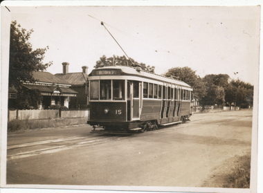
 Melbourne Tram Museum
Ephemera - Timetable, Melbourne & Metropolitan Tramways Board (MMTB), West Coburg - Domain Road - St Kilda Beach route, May. 1969
Timetable - listing the various runs, times at various timing point or locations for Essendon Depot, Weekdays as at 26-5-1969. Four photocopied pages stapled in the top left hand corner, for the West Coburg - Domain Road - St Kilda Beach route. On the rear of each sheet (all the same) details of the route, time points and changes for weekday peaks and Sundays. Front and back sheets scanned.Has number "17" in the top right hand corner - part of the index page.trams, tramways, mmtb, route 55, west coburg, domain rd -
 Bendigo Historical Society Inc.
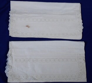
Textile - FAVALORO COLLECTION: BOLSTER PILLOW CASE WITH PIN-TUCKS AND BRODERIE TRIM, Early 1900's
Textiles. Fine linen fabric, white in colour. A 19 cm wide panel of fabric has been sewn to the top of the cover and is edged on three sides with finely embroidered broderie anglaise featuring a circular, six petalled flower impression. A panel of the same broderie runs through the centre of the panel and is bordered by a band of three pin-tucks on each side. An envelope of the linen fabric backs the bolster pillow.textiles, domestic, bolster pillow case with pintucks -
 Ballarat Tramway Museum
Photograph - Ballarat tram 31, Victoria St, Buninyong Railway bridge, John Phillips, 1968
Photo of Ballarat No. 31, just after leaving Victoria St. terminus, late 1960's or early 1970s crossing over the Eureka siding railway bridge. Taken by John Phillips. Tram has destination of Gardens via Sturt St. West, Twin Lakes advertisement on the front. In the background is Meagher's Hotel with Abbots Lager and Victoria Bitter sign. On the bridge is graffiti "Smash US Imperialism". On the Ballarat side of the bridge is a sign directing travellers to the "Eureka Caravan Park". Yields information about the vicinity of the Victoria St terminus and the bridge over the Buninyong Railway line.Black and White photograph mounted on heavy cardboard backing. Has 6 Velcro dots on the rear and marks where mounting devices have been removed on the rear. Note: image scanned in two runs through a scanner, resulting in the shading in the image file. .1 - Second copy with 4 black Velcro squares and 4 dots on rear - wider view on the right-hand side with an additional pole - not scanned.trams, tramways, victoria st, eureka, twin lakes, tram 31 -
 Whitehorse Historical Society Inc.
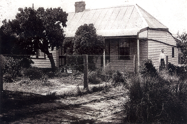
Photograph, Lowen family Home, 1/06/1920 12:00:00 AM
The home of Frederick & Julia Lowen was re-located in 1933 to allow Blackburn Road (which then ended in the vicinity of what is now Hawthorn Road) to be extended through to Burwood Road (now Burwood Highway). That section of Blackburn Road that now runs between Burwood Highway and High Street Road was originally Hewlett Road and from High Street Road to Princes Highway Was May Road.Black & white photo of the Lowen home at East Burwood in the mid 1920s. The lady on the right is presumed to be Julia Lowenlowen family home, east burwood -
 Royal Brighton Yacht Club
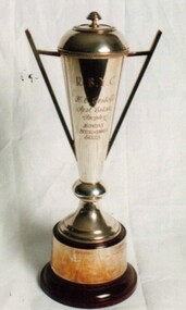
Cup, Costello Cup
Costello Cup Donor: H. C. Costello Deed of Gift: No The trophy was originally used in 1983 for a Spring and Summer Sunday Series. The trophy was then not used for a number of years when in 2004 it was used for a Saturday Winter Pursuit Series with extras being allowed. This series runs from June to September and alternated with the Blizzard Series and fleet starts. First Winner: Minerva, PJ Graham 1983 costello, pursuit -
 Falls Creek Historical Society
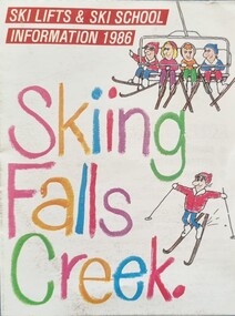
Flyer - Skiing Falls Creek, Information 1986
Part of yearly marketing and information material promoting Falls Creek ski region for the winter holidays, this brochure includes a Lesson Timetable Planner and booking details. During the summer of 1985-1986 an artificial snowmaking system had been installed at Falls Creek to service the Panorama, Towers, Tom Thumb and Playground Ski Runs. This flyer also recognised 25 years of skiing at Falls Creek.This item is important because it documents seasonal activities at Falls Creek Alpine ResortA small fold-out flyer including images, caricatures of skiers and a table of the price structure for activities at Falls Creek in 1986.On Cover: SKI LIFTS & SKI SCHOOL INFORMATION 1986 Skiing Falls Creekfalls creek marketing, falls creek ski, falls creek ski school -
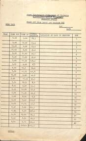
 Ballarat Tramway Museum
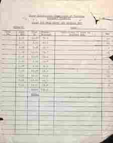
Document, State Electricity Commission of Victoria (SECV), "Trams out from depot and mileage run - Sundays"
Form titled "Trams out from depot and mileage run - Sundays", setting out the tram, time out and in, normal mileage, variation of cars in service and run number. Enable mileage records to be kept for each tram and its relevant run. Not known when used, could possibly match it with actual rosters/runs in the collection. See item 8020 and 3706 for weekday forms.Demonstrates the methodology for calculating the daily mileage of trams for a Sunday.Quarto duplicated form Ballarat branch.tramways, forms, mileage, ballarat depot, tramcars, timetables -
 Ballarat Tramway Museum
Photograph - Digital image, Wal Jack, 14/12/1945 12:00:00 AM
Yields information about the early use of Ballarat's 2nd bogie tram and its first day in service.Digital image from the Wal Jack Ballarat Album of No. 15 running out to Victoria St in Drummond St North at Duncan St. Tram has the destination of Victoria St. Taken by Wal Jack on 14-12-1945. See image i2 for rear of photograph. See image i3 for hi res scan of print. See image i4 for hi res scan of negativeIn ink on rear " SEC Ballarat Tramways bogie. 15 ex M&MTB C132 on first day runs 14-12-45 Gardens - Victoria St run. Photo taken in Drummond St North and showing No. 15 entering loop from Duncan St." with number "T537" within Wal Jack photo stamp.trams, tramways, drummond st nth, bogie trams, tram 15 -
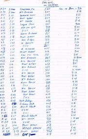
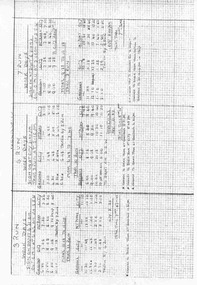 Ballarat Tramway Museum
Document - Table Cards (Sheets), State Electricity Commission of Victoria (SECV), SEC Ballarat tram, Aug. 1971
Set of 10 sheets, photocopied on heat sensitive paper, foolscap size graph paper sheets giving the weekday tables or runs for the SEC Ballarat trams following the closure of the Victoria St. - Gardens via Drummond St. North service. Gives details of 29 tables or runs, numbered from 3 Run to 38 Run. Each sheet headed "Weekdays". Each run details where the driver/conductor would sign on, time, the trips, meal breaks, finish time and the total time of the shift. A number of the sheets have minor notes or changes to the timetable in ink, primarily about the change of tramcar type. Sheet 3, Run 12 had a handwritten addition over the run details at the base of the run details. Was fixed to sheet with adhesive tape. Has been stored in separate envelope with sheets. Stored separately with these sheets are a photocopies of each sheet reduced to A4 size.trams, tramways, timetables, sec, ballarat, crews -
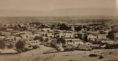 Ballarat Heritage Services
Image, Stawell, c1918, c1918
Pastoral runs in the Stawell area were selected in the 1840s, but it was the gold found by a shepherd in the district in May 1853 that provided the real reason for the foundation of a township. By August 1854, 5,000 people were seeking their fortune at the Pleasant Creek goldfield. By 1857 the fabulously rich deep alluvial leads to Commercial Street and Deep Lead had been discovered and rushes of eager gold seekers brought 20,000 people to the fields.Black and white photograph of the central Victorian town of Stawell (formerly known as Pleasant Creek). .stawell, pleasant creek -
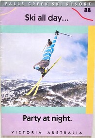 Falls Creek Historical Society
Magazine - Falls Creek Resort - Ski All Day
A part of a yearly marketing magazine program promoting Falls Creek ski region for the winter holidays. It includes 24 pages of detailed information and maps describing resort facilities, different runs and access to the snow. Available accommodation is explained with the inclusion of tariffs for 25 different venues in both lodges and apartments for 1988. Transport, ski hire, other village services and insurance and booking agents are also explained. This item is important as it documents seasonal activities at Falls Creek Alpine ResortMagazine titled "Falls Creek Resort - Ski All Day ....Party At Night". It contains 24 pages of images, information, maps and advertising.falls creek marketing, falls creek 1988, falls creek advertising -
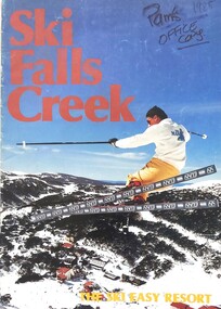 Falls Creek Historical Society
Magazine - Ski Falls Creek - The Ski Easy Resort
A part of a yearly marketing magazine promoting Falls Creek ski region for the winter holidays. It includes 24 pages of detailed information and maps describing resort facilities, different runs and access to the snow. Available accommodation is explained with the inclusion of tariffs for 25 different venues in both lodges and apartments. Transport, ski hire, other village services and insurance and booking agents are also explained. The brochure was published by Victour.This item is important as it documents seasonal activities at Falls Creek Alpine ResortAn A4 sized magazine titled "Ski Falls Creek - The Ski Easy Resort". It consists of 24 pages of information and images.falls creek 1985, the ski easy resort, falls creek marketing, falls creek maps, falls creek activities -
 Ballarat Tramway Museum
Document - Form/s, State Electricity Commission of Victoria (SECV), "Trams out from depot and mileage run - weekdays", c1960
Form titled "Trams out from depot and mileage run - weekdays", setting out the tram, time out and in, normal mileage, variation of cars in service and run number. Enable mileage records to be kept for each tram and its relevant run. Not known when used, could possibly match it with actual rosters/runs in the collection. See item 9981 for a Sunday form. and 3706 for another weekdays form.Demonstrates the methodology for calculating the daily mileage of trams.Foolscap duplicated form, SECV Ballarat branch.trams, tramways, forms, mileage, ballarat depot, tramcars, timetables -
 Warrnambool and District Historical Society Inc.
Original Document, Map: Agricultural area of Ballangeich 1865, 1865
George Eddington arrived in Australia in 1839 and named and established property in 1841 calling the property Ballangeich after a Pass near his home town of Stirling in Scotland. It is situated 151 miles west of Melbourne and to the south of Mortlake and was originally part of the Mortlake shire, which was proclaimed 26th Jan 1864. Nearest streams are the Hopkins Riverand Lyall and Drysdale creek running through good agricultural land. This map relates to the breaking up of large runs which the Victorian government enabled through selection acts of the 1860's. The previously larger runs which were mainly cattle and sheep based were now more open to closer settlement and a greater variety in farming.The lots range in size from approximately 50 acres to around 600 acres.Some areas are set aside for reserves. By 1886 the population of Ballangeich had grown to around 600 with an hotel, three state schools and a church.Tri weekly coaches ran to Colac, Warrnambool and Camperdown providing access to supplies mail and communication. This map is typical of many which were produced in the 1860's in Victoria during a significant period of Victoria's and Warrnambool district history.Rectangular light card paper with black text showing allotments of land The area is coloured in green with scale at bottom right cornerAt the top: Plan of the Agricultural area of Ballangeich 1865 At the bottom left: Prepared by the Board of Lands & Works in accordance with the Amending Land Act 1865 Lands & Survey Office Melbourne 13th April 1865. With signaturehistory of warrnambool, ballangeich, land surveys victoria 1865, lands act 1865 victoria, ballangeich map 1865 -
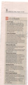 Ballarat Tramway Museum
Newspaper, Herald Sun, "shorthauls" & "Don't forget Ballarat", 10/08/2001 12:00:00 AM
Newspaper clipping from the Herald Sun (Melbourne) 10/8/2001, from page 8 of the "travel" supplement. Titled "Don't forget Ballarat" in the "shorthauls" column. The supplement was primarily an issue involving rail travel, tourist railways and rail themes. Titled "Don't forget Ballarat" in the "shorthauls" column, the clipping noted that Ballarat Tramway Museum runs a weekend service at Lake Wendouree. Gave times, fares and phone number.btm, rail travel, marketing -
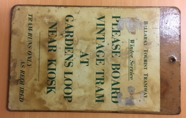 Ballarat Tramway Museum
Sign, Ballarat Tramway Preservation Society (BTPS), Winter Tram Service, c1980
Sheet of Masonite with a printed sheet of paper, glued and then varnished with a hole in the top of the sign. Prepared to act as a notice or a sign to intending passengers to Board BTPS or BTM tram service at Gardens Loop. Wording "Ballarat Tourist Tramway Winter Service PLEASE BOARD VINTAGE TRAM AT GARDENS LOOP NEAR KIOSK TRAM RUNS ONLY AS REQUIRED" Image added 24-12-2016 See 1979-1980 Annual Report.trams, tramways, btps, timetables, signs, tram stops -
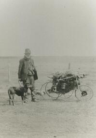 Lake Bolac & District Historical Society
Black and white photograph, Swagman
Swagman, travelling through the Lake Bolac district. These 'swaggies' often had regular, seasonal 'runs' which they would follow, returning to the same hamlets and farms at the same time every year to ask for minor chores in order to earn a meal or to obtain some flour, tea and sugar. After both wars, the numbers of swaggies increased as returned soldiers, who couldn't settle to (or couldn't find) regular employment, took to the roads.lake bolac, swagman -
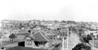 Surrey Hills Historical Society Collection
Photograph, Surrey Hills viewed from 'Quamby' at 293 Mont Albert Road, c 1915, 1915
Quamby was built in 1898. From 1900/1903-1924 it was the home of Andrew Sherar and family. From 1924-1960s it operated as Mosgiel Hospital under the direction of Matron Elizabeth Anderson. Until Box Hill Hospital opened most Surrey Hills children were born at Mosgiel or at Nethercourt Hospital in Wilson Street or later in Union Road when Matron Tank moved her hospital here. Mosgiel Hospital was demolished c 1975 after it was sold by Box Hill Hospital. It was replaced by units. Andrew Sherar was conductor of the Wyclif Church choir for many years and was a member of the Melbourne Liedertafel. Isie Sherar was organist at Wyclif Church and also taught piano in Union Road. Connie Sherar was in the Wyclif choir and married Ernest Swan, an elocutionist and orator. Dorothy Sherar was a pianist and accompanist. Elsie Sherar was also in the Wyclif choir and was a soloist; she later moved to Templestowe. Ken Sherar was a boy soprano at St Paul's Cathedral; he later moved to Queensland.Black and white photo looking south down Vincent Street from 'Quamby', located at 293 Mont Albert Road, Surrey Hills. In the centre foreground is a timber house with 2 chimneys and a tiled hip roof. It has a return veranda and is fenced on 2 sides by paling fences and picket fences on the other two. In the background are many more houses. A road lined with power poles runs from the right foreground to the middle distance.quamby, vincent street, edwardian style, topography, andrew sherar, isie sherar, connie sherar, dorothy sherar, ken sherar, elsie wappet -
 Melbourne Tram Museum
Document - List, Melbourne & Metropolitan Tramways Board (MMTB), "Car used on 22/8/1969", 22/08/1969 12:00:00 AM
Carbon copy of a report or list written on 3 ruled Foolscap sheets, that were stapled in the top left hand corner., titled "Car used on 22/8/1969", listing the various runs by number for Kew Depot, time, destination, car used and car in time. On rear of first sheet has details of the day and night services. The cars used are only list on the first and part of the second sheet. Was this a record kept by the depothas in ink in the top left hand corner "60 crew"trams, tramways, tramcars, kew depot, tram services, records -
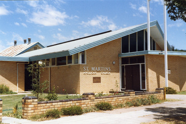 Charlton Golden Grains Museum Inc
Photograph, Charlton Shire, St Martin's Anglican Church c. 1989, c.1989
The current St Martins Anglican Church was built in 1963 to replace the first weatherboard church built in 1889. Shire of Charlton photo c. 1989.Colour photo of St Martins Anglican Church. White brick single storey building with an iron roof and blue fascia trim. There is a dark coloured double door with windows on either side and above it. There are large clerestory windows on the front and side of the building. A low pale brick fence capped with darker brick runs beside the footpath. An older weatherboard building with a rusty iron roof is partially visible behind the main church building. st martin's anglican church, church, angllican, pastoral care