Showing 411 items
matching signage
-
 Kiewa Valley Historical Society
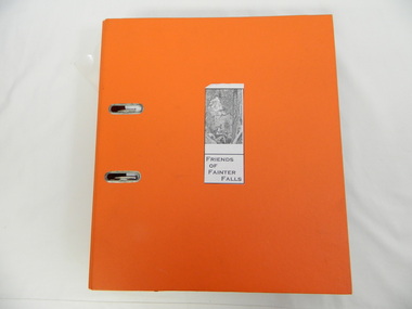
Folder - Fainter Falls, 2003 - 2008
The Fainter Falls Walking Track was originally accessible via a fire fighting access trail, which was used by fire fighters putting out spot fires caused by lightening strikes. The fires in the summer of 2003 highlighted the beauty of the area and provided the residents with the opportunity to consider the redevelopment of the trail. Work to establish a 700 metre grade 2 walking trail with a 50 metre grade 3 extension trail to the Falls began in 2005. It also includes 3 observation decks, a bridge over a creek crossing, car parking and interpretive signage.A Friends of Fainter Falls committee was formed to work towards the construction of a track to Fainter Falls. The contents of this folder is evidence of how a local community achieved its goals for such a project in 2003 - 2008.Large orange lever arch folder bound with 2 rings. Contains the history of the redevelopment of the Fainter Falls track 2003 - completion at the end of 2008. It is divided into: Funding Proposals. Correspondence Inwards & Outwards. Minutes and Letters of Support. Inserted separately in a large white and yellow Express Post envelope is additional information including chronology, minutes, newspaper cuttings Inserted separately is the 'Small Towns Development Fund' Application Form 2006.Cover blankfainter falls. bogong. walking trail. fire track. kiewa valley community. -
 Whitehorse Historical Society Inc.
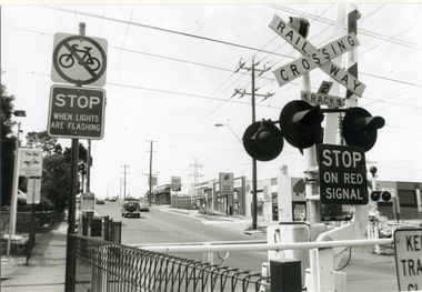
Photograph, Railway Crossing - Heatherdale Road, 2000
Produced as one of a series of 24 prints commissioned by Nunawading & District Historical Society -|Theme: Intersections of Mitcham and Nunawading 2000/2001.|See also Series by P. Simmenauer on the same theme.Black and white photograph - print and negative of Railway Crossing on Heatherdale Road near Heatherdale railway station looking north towards intersection of Whitehorse and Heatherdale Roads, from L - R Station signage 'The Met/Heatherdale Station (sign to be replaced by new owners Connex - see also No. 3 neg). Note Pedestrian & Cyclists signs; strip shops Hungry Jack's fast food; Dyns LPG Service Garage; ACE Auto Services; bus shelter.railway crossing, heatherdale road, mitcham, connex, 'the met', dyns, ace auto services, hungry jack's fast food outlet -
 Ringwood and District Historical Society
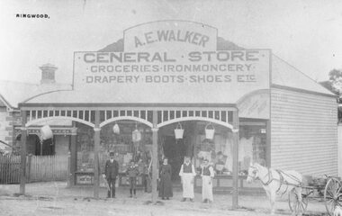
Photograph, Maroondah Highway Central, Ringwood. A.E. Walker's General Store, Main Street, Ringwood - c.1910
Black and white photograph (3 copies, 2 large, 1 small post card) Typed below one large copy: "Walker's General Store- Main St. 1912. Written on rear of backing sheet: "Walker came from Gembrook in 1910. Later sold shop to Capt. Miles. Coffee Palace built either side of shop." Signage on front of building reads: "A.E. Walker. General Store. Groceries, Ironmongery, Drapery, Boots, Shoes, Etc. -
 Kiewa Valley Historical Society
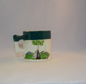
Mug Stoneware
This ceramic mug is titled "Bill Bogong's Mug" in honour of one of Australia's Scouting (Rovers) notable office holders, Mr.W.F."Bill" Waters. He was born on 22nd August 1897 in Taralgon, Victoria, Australia and died 8th October 1968 in Fitzroy, Victoria. He was instrumental in the Rovers building two chalets in the Victorian Alps. The Victorian Award of the National Rover Service Award(1980) has been named after Bill Waters. Bill Waters was also the leader of the first team that climbed Mount Bogong in winter in 1929. Also was part of rescue team of what is now know as the Cleve Cole tragedy on Mt Bogong in the mid 1930's. There is also a water fall named after him Waters Falls on the Bogong High Plains. W.F."Bill" Waters aka "Bill Bogong" (Bogong mountain, were his ashes were scattered), was not only a prominent bush walker (Melbourne Walking Club) of the high country (Victorian Alps) but was instrumental in establishing two Chalets. One of these Chalets was the first one to be built on the Bogong High Plains. This item, "Bill Bogong's Mug" is what the Flinders Petrie(famous English Egyptologist/Archaelogist) Rover Crew(formed in 1940) presented newly invested members of the exclusive(200 membership) Alpine Rover Crew. The Melbourne Walking Club has a long history with the Victorian High Plains area, of which the Kiewa Valley is an integral part of the Victorian Alpine Region. Due to the connections Bill Waters has with the Bogong High Plains and Mt Bogong this cup has a lot of significance to the social history of the area.. Round glazed stoneware mug, white in colour, with a heritage green coloured band covering the top rim and handle. Written inscription on the front "Bill Bogong's Mug" in large print and beneath it, in smaller print, "with compliments from Flinders Petrie Rover Crew" The other side of the mug is a free hand landscaped drawing of green bush and blue hills with a tree supporting a tent and a camp fire (with smoke rising from it).To the left of the inscription is the Scout (Rover) emblem coloured black with an unraveled and unwritten signage scroll fowler ceramics, local alpine history, alpine rovers, scouts, mugs, mt bogong, bogong high plains -
 Eltham District Historical Society Inc
Photograph, Shire of Nillumbik World War One Memorials tour, 10 August 2016, 10 August 2016
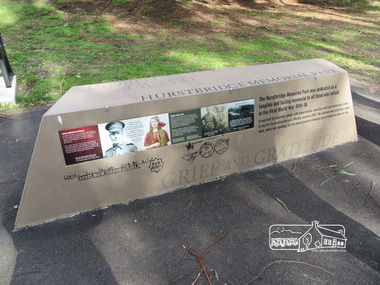
As part of a program to acknowledge the Anzac Centenary Nillumbik Shire Council partnered with Yarra Plenty Regional Library to provide a bus tour with commentary of local sites of significance. These included Eltham township, the Shire of Eltham War Memorial at Kangaroo Ground, Christmas Hills, Hurstbridge memorial recreation park and finished at Eltham Library to view the Writing the War exhibtion at Eltham Library Community Gallery. In June 2014 Nillumbik Shire Council received Anzac centenary Local Grants Program funding to create new interpretative signage that acknowledged the history of the Hurstbridge Memorial Recreation Park as a memorial to all who served in the First World War. Born Digitalworld war 1, war memorials, shire of nillumbik, interpretative signage, hurstbridge -
 Eltham District Historical Society Inc
Photograph, Shire of Nillumbik World War One Memorials tour, 10 August 2016, 10 August 2016
As part of a program to acknowledge the Anzac Centenary Nillumbik Shire Council partnered with Yarra Plenty Regional Library to provide a bus tour with commentary of local sites of significance. These included Eltham township, the Shire of Eltham War Memorial at Kangaroo Ground, Christmas Hills, Hurstbridge memorial recreation park and finished at Eltham Library to view the Writing the War exhibtion at Eltham Library Community Gallery. In June 2014 Nillumbik Shire Council received Anzac centenary Local Grants Program funding to create new interpretative signage that acknowledged the history of the Hurstbridge Memorial Recreation Park as a memorial to all who served in the First World War. Born Digitalworld war 1, war memorials, shire of nillumbik, hurstbridge, interpretative signage -
 Mission to Seafarers Victoria
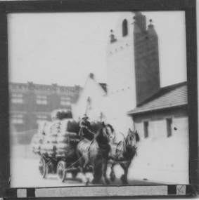
Slide - Glass slide, Black and white, Mission to seamen building, Flinders St and loaded horse-drawn wagon, circa 1920s
This Spanish Mission style building first opened in 1917 and has been in continual use since as the Mission to seamen and later Mission to Seafarers at a location initially known as the extension to Flinders St near the Australian Wharf and later address known as 717 Flinders St. "The Extension Bond and Free stores" building which can be seen in the background can be identified on an aerial photograph of the area dated 1927.This image besides showing an early view of the current Mission to Seafarers building also features a glimpse of the early 20th C (Flinders St) Extension Bond ( Store ?) building positioned to make use of the Yarra-side docks known as the Australian Wharf.Positive photograph on medium format glass slide ; b & w image of the chapel and bell tower of 1917 Mission Building, extension to Flinders St. with a loaded horse-drawn dray or wagon being driven in the foreground. . In the background of image can be seen a section of a large warehouse or Bond store building, visible signage reads: "Extension Bond"in upper case letters. The foreground details appear to have been hand touched up with linear ink highlights. Image is slightly blurry. The slide is edged with adhesive tape.pencil cross at lower right corner on adhesive tape edgingmissions to seamen institute, mission building, extension bond store, warehouse -
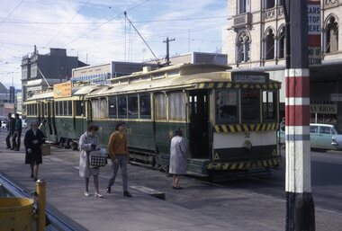
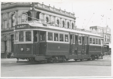 Ballarat Tramway Museum
Photograph - Black & White Photograph/s, 13/05/1947 12:00:00 AM
Black and White print contained within the Wal Jack Bendigo and Geelong Album, see Reg Item 5003 for more details. Photo of Car No. 31, crossing Ryrie and Moorabool Streets, first bogie to run in Geelong. Photo taken 13-5-1947. The tram has the destination of East. In the background is "The Union Bank of Australia. Limited". Above the front of the tram is a set of "Bar" traffic lights with signage "Green - Go - Red - Stop" No details on photographer. Has the Union Bank of Australia. Limited building in the background.trams, tramways, geelong, ryrie st, moorabool st, bogie trams, traffic lights, tram 31 -
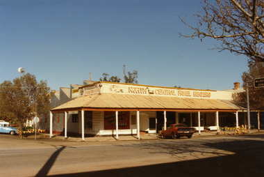 Charlton Golden Grains Museum Inc
Photograph, North Central Panel Beaters 1987, c.1987
North Central Panel Beaters 1987, formerly Charlton Motors Pty Ltd Service StationColour photograph showing North Central Panel Beaters building on the corner of High and Armstrong Sts. Red car in front of shop on High St, blue & white vehicle on LH side on Armstrong St. Sign attached to verandah showing St Arnaud 42. Signage on front window says Mechanical Repairs, Automotive Service Centre, Ph S?. 1389. Safety tape around tree on LH side of photo and barricades on the High St kerb at the end of the verandah. Telstra tower visible in background.north central panel beaters, charlton motors, business, industry, armstrong street, charlton -
 Eltham District Historical Society Inc
Photograph, Shire of Nillumbik World War One Memorials tour, 10 August 2016, 10 August 2016
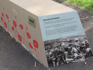
As part of a program to acknowledge the Anzac Centenary Nillumbik Shire Council partnered with Yarra Plenty Regional Library to provide a bus tour with commentary of local sites of significance. These included Eltham township, the Shire of Eltham War Memorial at Kangaroo Ground, Christmas Hills, Hurstbridge memorial recreation park and finished at Eltham Library to view the Writing the War exhibtion at Eltham Library Community Gallery. In June 2014 Nillumbik Shire Council received Anzac centenary Local Grants Program funding to create new interpretative signage that acknowledged the history of the Hurstbridge Memorial Recreation Park as a memorial to all who served in the First World War. One of the panels discusses women. Born Digitalworld war 1, war memorials, hurstbridge, interpretation panel, interperative signage -
 Ballarat Tramway Museum
Photograph - Digital image Set of 9, Adrian Ponton, 31/07/2021 12:00:00 AM
Set of 9 digital images taken by Adrian Ponton on 31 July 2021 - the delayed day (COVID 19) to celebrate the foundation of the BTPS. .1 - 40 on the depot fan .2 - 13 running in on the access track .3 - 40 and 13 on the depot fan with the new building in the background .4 - 40, 33 and 38 on the depot fan .5 - Tramcar signage re Fares and notices .6 - view looking out of the front of the tram 40 on the access track .7 - crossing 407 at Gardens Loop .8 - 40 at St Aidans .9 - dittotrams, tramways, btm, st aidans drive, gardens loop, celebrations, wendouree parade, access track, tram 40, tram 33, tram 18, tram 13, tram 407 -
 Ballarat Tramway Museum
Slide - 35mm slide/s, Peter Moses, Aug. 1971
Colour slide - Photo of SEC Ballarat Trams No. 32 and 35 at the Sturt St. south side "City" terminus. No. 32 has destination of "Gardens via Drummond Nth" and No. 35 has "Everything's under control in my all electric kitchen" SEC roof advertisement panel. Photo shows passengers boarding tram and stop signage arrangements. Has buildings on the south side of Sturt and Lydiard in the background. Kodak cardboard mount slide, taken by Peter Moses August 1971. Image btm2047ia - cleaned up by Peter Waugh 9/2021.On back of slide in blue ink "N32 Ballarat Sturt St. terminus." and in bottom left hand corner in black ink "P. Moses".tramways, trams, sturt st, lydiard st north, tram stops, tram 35, tram 32 -
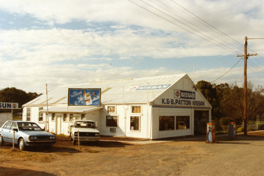 Charlton Golden Grains Museum Inc
Photograph - Patton's Garage West Charlton c. 1987, Charlton Shire, c.1987
The garage was established in the 1930s by Mr Gamble. Other proprietors were Perc Kimberley 1943-46, Henderson 1946, Neil Rogers. K. & B. Patton ran the garage from 1960s - 2008Colour photo of K. & B. Patton's Garage. The garage is a white, weatherboard single story building with a corrugated iron roof. There small lean-to on the LH side of the building. There is a large entrance and two large windows on the front. There are two petrol pumps at the front of the building. A blue car and a white utility are parked at the LH side of the garage. The signage on the front of the building reads K. & B. PATTON NISSAN and there is a NISSAN sign painted on the roof. There is a sign for Peter Stuyvesant cigarettes on the roof of the lean-to. A telegraph pole and the entrance to Gordon Park is on the right of the photo.perc kimberley, k & b patton, gamble, henderson, neil rogers, business, industry -
 Eltham District Historical Society Inc
Photograph, N. J. Tillings Timber Factory, 15 June, 1975, 15/06/1975
N. J. Tillings Timber Factory was part of the Brougham Street, Light industrial area, Eltham. Brick bulidings includes signage: Wakefield Pr... (printer?) No 17 Building C. This is one of 7 B/W 8x10 inch photos with notes on obverse by Dick Crichton. Accompanying letter from Florence Chrichton 2013 : "Originally sent to Shire of Eltham Engineer, Mr. McDonald. [These photographs were part of their campaign to the Shire of Eltham in 1975] claiming that the zoning regulations were being breached by the occupants of various factories in the nearby light industrial zone [Brougham Street, Eltham] - to the detriment of those living in adjoining residential zones, and that, despite .. earlier objections and complaints, nothing was done about it."1 black and white photograph printed with white borderInscribed on back: "Weekend photograph of factories in Brougham Street surrounded by by residential zone. On weekdays cars surround premises - these have been built approx. two years - where is the landscaping? * Undeveloped light industrial land. Careful planning needed for future. Being on high elevations backs of future buildings will be seen from Main Road Eltham and future Art Centre complex. Also Bolton Street becoming heavily used arterial road. Off street parking facilities most important." . The front of the photo has pen marks indicating points of interest.industrial estate, brougham street, eltham -
 Eltham District Historical Society Inc
Photograph, N. J. Tillings Timber Factory, 15 June, 1975, 15/06/1975
N. J. Tillings Timber Factory was part of the Brougham Street, Light industrial area, Eltham. Brick bulidings includes signage: Wakefield Pr... (printer?) No 17 Building C. This is one of 7 B/W 8x10 inch photos with notes on obverse by Dick Crichton. Accompanying letter from Florence Chrichton 2013 : "Originally sent to Shire of Eltham Engineer, Mr. McDonald. [These photographs were part of their campaign to the Shire of Eltham in 1975] claiming that the zoning regulations were being breached by the occupants of various factories in the nearby light industrial zone [Brougham Street, Eltham] - to the detriment of those living in adjoining residential zones, and that, despite .. earlier objections and complaints, nothing was done about it."1 black and white photograph printed with white borderInscribed on back: "Photo taken from corner Bolton and Brougham Streets showing undeveloped light industrial land used as storage (of portable toilets!). In the best tradition of Robin Boyd's 'Great Australian Ugliness.' Infringement of zoning regulations." industrial estate, brougham street, eltham, portable tiolets, 1975, bolton street, dick crichton, n.j. tillings, timber factory, shire of eltham -
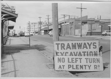 Melbourne Tram Museum
Photograph - Tramway excavation signage at Bell St and Plenty Rd, Preston, c1960s
Photograph shows Bell St, Preston looking eastward toward Plenty Rd with the newly constructed (1958-60) Preston and Northcote Community Hospital in the background. Signage in the foreground reads 'Tramway Excavation - No left turn at Plenty Rd' which may indicate works outside the East Preston tram depot (opened 1955) located in Plenty Rd less than 100 metres north of Bell St. In the mid-ground, several passengers wearing coats wait for a Bell St bus and numerous motor cars are shown on this narrow stretch of Bell St that would not be widened until the 1970s. While no note is attached, the model of motor cars suggest a date in the 1960s.Yields information about Bell St preston in 1960s Black and white photograph stuck to thick boardm&mtb, bell st, preston, plenty rd, tramway signage, preston and northcote community hospital, bell st widening -
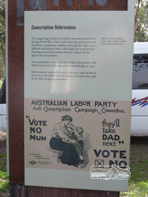 Eltham District Historical Society Inc
Photograph, Shire of Nillumbik World War One Memorials tour, 10 August 2016, 10 August 2016
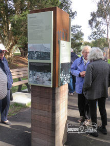
As part of a program to acknowledge the Anzac Centenary Nillumbik Shire Council partnered with Yarra Plenty Regional Library to provide a bus tour with commentary of local sites of significance. These included Eltham township, the Shire of Eltham War Memorial at Kangaroo Ground, Christmas Hills, Hurstbridge memorial recreation park and finished at Eltham Library to view the Writing the War exhibtion at Eltham Library Community Gallery. In June 2014 Nillumbik Shire Council received Anzac centenary Local Grants Program funding to create new interpretative signage that acknowledged the history of the Hurstbridge Memorial Recreation Park as a memorial to all who served in the First World War. One of the tall panels includes a discussion of conscription in World War One. Born Digitalworld war 1, war memorials, shire of nillumbik, hurstbridge, interpretative signage, conscription -
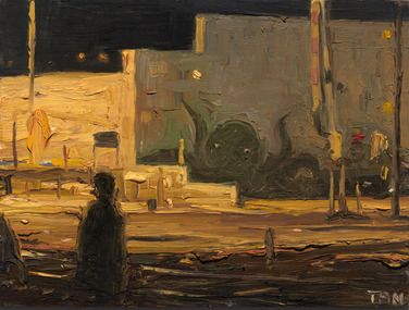 Merri-bek City Council
Oil on board, Shaun Tan, Octopus 2, 2016
Shaun Tan is best known for his illustrated books and short films that deal with social, political and historical subjects through dream-like imagery and fantastic creatures. In addition to his book and film work, Tan is a respected and prolific painter. Octopus 2 is one of three paintings of Anstey Station, which is next to Tan’s art studio. Nearby, there is an octopus painted on the roller door of a bait shop. Tan observes that the octopus is usually only visible at night, and then not very well: "It is an eerie vision, a bit comical too. There is something about the tucked-away grouping of high and low walls, the amber light and the jumble of signage that I find very evocative, as if there is some spirit being tucked up in this unlooked-at pocket of the rail-line”. -
 Ballarat Tramway Museum
Photograph - Digital image Set of 10, 19/02/2011 12:00:00 AM
Yields information about the 2011 appearance of Hospital Corner.Set of 10 digital images of Hospital Corner, taken by Warren Doubleday on 19-2-2011 for use in BTM web presentation - Hospital Corner. .1 - SE Corner - La Porchetta's .2 - NE Corner - Shell service station .3 - Looking across to SE corner .4 - Looking across to SW corner - Celebrations store .5 - looking across to NW corner and Hospital .6 - ditto .7 - ditto .8 - Drummond St signage on western side .9 - Celebrations store on SW corner .10 - Davis bus turning from Drummond into Lydiard Sts.trams, tramways, hospital corner, drummond st, sturt st, davis buses -
 Ballarat Tramway Museum
Photograph - Digital image, 1970s
Yields information about the Bakery Hill Victoria St and the Caltex Service Station.Digital image, black and white, of No. 26 descending Bakery Hill to Stone's Corner, Victoria and Main St with the Caltex service station in the foreground. Has a lady with slacks walking across the road and a boy wheeling a bike down the footpath. Note the Highway direction signs and service station signage. O'Brien Motors and a book and record shop on the north side Bakery Hill Victoria St. shops. See Reg 4603 for the subsequent photo at this location. Photo taken by Peter Bruce 1970's and 1971, prior to the closure of the Ballarat tramway system. Peter's Title of image: "No. 26 Bridge and Vic1"trams, tramways, victoria st, main st, stones corner, bakery hill, tram 26 -
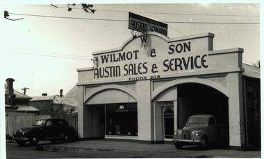 Bacchus Marsh & District Historical Society
Photograph, Wilmot and Son Austin Sales and Service Main Street Bacchus Marsh
This building, located at 97 Main Street Bacchus Marsh, was built by Mr George Muir in 1920 using bluestone walls from Landsberg House, a former boarding school at Mt. Blackwood. In 1946 Mr W. J. Wilmot opened a car sales business which was sold in 1954 to trade as Stamford Motors. Subsequently, various businesses operated on this site, and is still in use, presently as an accountancy business.Black and white photographic print. Photograph dates from the 1940s and shows a bluestone building with lintels of local sandstone supporting a pediment with a sign advertising Austin cars fixed on top. Signage on the pediment reads: W 1930 WILMOT & SON AUSTIN SALES & SERVICE PHONE 206. The frontage is divided in two, both sections topped by an arch. The left-hand section is glass-fronted, the right section open for vehicle access. The door between the two sections is also arched. Two vehicles are parked at the front, a sedan and a ute, presumably both Austins. The bluestone building materials are visible at the side.shops bacchus marsh vic., main street bacchus marsh vic., garages, landsberg house, w j wilmot -
 Eltham District Historical Society Inc
Photograph, Eltham Produce Store, Main Road, c.1960
Operated by John McLean and Son Situated just south from opposite Arthur Street, opposite the Eltham Village Shopping Centre. In 1974 the site was the location of the B.P Garage and opposite was the Woolworths Arcade. The Produce Store sold hay and grain. To the right was Garnet Burges' second hand scrap metal and bottles, then the blacksmith shop, which was later taken over by Garnet with second hand furniture and next door to that was Ray Staff's grocery store. The brick building has signage to promote Tanox Paint and Permoglaze products. This building was demolished by 1963 for the BP Evergreen Service Station. Photo taken at same time as Shire of Eltham Pioneers Photograph Collection No. 785 which is a view from near Arthur Street and Main Road intersection.Colour photograph copy of original photoshops, main road, eltham, eltham produce store, tanox paint, permaglaze, produce station, john mclean and son, garnet burges -
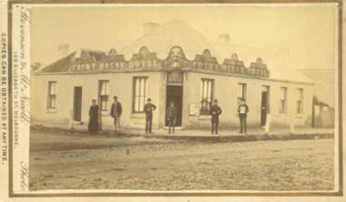 Bacchus Marsh & District Historical Society
Photograph, Court House Hotel Main Street Bacchus Marsh 1883
This building on the corner of Court House Place and Main Street Bacchus Marsh was a licensed hotel since 1864. Prior to 1864 the building was in use as a saddlery business, established by Joseph Purday and Alfred Smith. In 1864, Purday and Alfred Tanner converted the shop to a hotel. Tanner, followed by his wife Ann, were licensees until 1892. The hotel signage above the door features the Prince of Wales feathers, an acknowledgement of the Prince of Wales Volunteer Light Horse Werribee unit which used the hotel for their meetings. In 1911 the single-storey hotel was demolished and a two-storey brick hotel was built. The identities of the five men and one woman in the photo are not known. The woman at the left of the group is possibly Ann Tanner who was the licensee around the time this photograph was taken. Small sepia unframed photograph on card with gold border framing photograph. Housed in the album, 'Photographs of Bacchus Marsh and District in 1883 by Stevenson and McNicoll'. A group of five men and one woman can be seen standing in front of the Court House Hotel building, Main Street Bacchus Marsh. A large ornate sign around the roofline bears the words “Courthouse Hotel”. Above the door a sign featuring the Prince of Wales feathers also has the name “Ann Tanner.” One of the men is displaying a document which apparently is of some importance, now lost.On the front: Stevenson & McNicoll. Photo. 108 Elizabeth St. Melbourne. COPIES CAN BE OBTAINED AT ANY TIME. On the back: LIGHT & TRUTH inscribed on a banner surmounted by a representation of the rising sun. Copies of this Portrait can be had at any time by sending the Name and Post Office Money Order or Stamps for the amount of order to STEVENSON & McNICOLL LATE BENSON & STEVENSON, Photographers. 108 Elizabeth Street, MELBOURNE. stevenson and mcnicoll 1883 photographs of bacchus marsh and district, hotels bacchus marsh, court house hotel bacchus marsh -
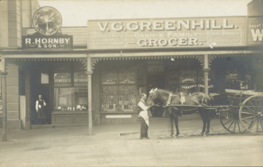 Kew Historical Society Inc
Postcard - V.G. Greenhill's Grocery Store, High Street (Kew), c.1902
R.H. Hornby & Sons, jewellers, and V. Greenhill's Grocery Store were located at 43 1/2 and 45 High Street (formerly Bulleen Road) respectively, in the block of shops between Brougham Street and Walpole Street. The grocery first appears at this location in 1893 but only in 1902 is the jeweller's shop located next door. (Sands & McDougall Directories). The Greenhill family were significant pioneers of Kew in the nineteenth century and their members participated in many civic, community and sporting organisations.Original sepia, real photo postcard of two shops in High Street, Kew, circa 1902. The businesses were R. Hornby, jewellers and opticians, and V.G. Greenhill, grocer. The proprietor of the jeweller's shop stands in his doorway while a member of staff of Greenhill's is standing on the road with a horse and cart owned by the business. The signage on the grocery shop identifies the kind of business offered - Choice fruits & confectionery / Dairy Produce a specialty. On the windows from left to right are advertisements for Fry's Chocolate, Fry's Pure Cocoa, and Cadbury's Cocoa and Cadbury's Chocolate. Above the doorway is a pane of etched glass reading GREENHILL 45.Unmarked postcard layout on reversev greenhill, grocery stores -- kew (vic.), jewellers -- kew (vic), high street -- kew (vic.), businesses -- kew (vic), hornby family, greenhill family -
 Charlton Golden Grains Museum Inc
Photograph, Charlton Shire, Lou's Cafe High St Charlton c.1987, c.1987
Lou's Cafe c. 1987. In the 1930s and early 40's it was Riches Cafe and Billiards Saloon. Sold to Halligan's, Duggans, Jerry Cowell until 1951 when Luths took over the building as a Car and Tractor agency. Next door was Bennett's Shoe Repair Shop which was later a Stock & Station Agency. Part of a streetscape series done for the Shire of Charlton c. 1987.Colour photograph of a single storey building. Signage on the windows reads Lou's CAFE and on the awning Lou's MILK Bar. Other signs on the windows read Fresh Fruit VEGS, meals, TAKE AWAY FOOD, FISH & CHIPS, HAMBURGERS. Signs above the awning advertise Pauls Streets and Peters ice creams. Two cars parked in front of shop and a man and a woman are standing beside one of the cars. Drive way to the left of the cafe and a single storey, glass fronted building is on the LH side of the photo. Signs on the windows read Crafts, Haberdashery, Gifts and BAGGAGE. To the right of the cafe is a yellow-green fence.lou's cafe, riches cafe and billiard saloon, halligan, duggan, jerry cowell, business -
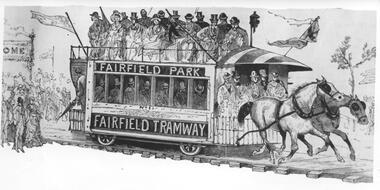 Melbourne Tram Museum
Photograph - Black & White Photograph/s, c1890
Black and white photograph of an illustration of the Fairfield Horse Tram. The illustration is from The Australasian Sketcher with Pen and Pencil (Melbourne, Vic. : 1873 - 1889), No 188 Vol XIIL, 14/1/1885. The magazine was owned by the Argus. The drawing is from a series of sketches at one of the Saturday land sales. The tramcar is numbered 1 and has signage Fairfield Park and Fairfield Tramway. The tramway was operated by Charles Henry James in an attempt to sell land developed by him north of the Fairfield railway station. The tramway operated from 20/12/1884 until its closure in 1890. Stamped on the back "...The Argus...negative No X2656"trams, tramways, argus, fairfield, horse trams, tram 1 -
 Ballarat Heritage Services
Photograph - Digital photograph, Eureka Stockade Replica, 14/12/1993
Please find 5 photographs taken by me & my wife Brenda, at Ballarat, on 14 December 1993. Unfortunately, I did not take photographs of the building that housed the exhibit, probably because I thought just how sad and pathetic the entire memorial display looked. It comprised a reconstructed slab hut and nearby a partly-rebuilt fence that represented the hastily-built Eureka Stockade. The signage that detailed the events surrounding the Eureka Stockade was affixed to the hut wall beside the entrance to the interior diorama. In the first photograph, you can see the dark, bare timber colour of the slab wood that held the signage plus (on the left side) one of the numerous holes in the slab walls. This made the display very cold and draughty in its interior. Once inside, you were confronted with an earthen, gravel and leafy floor, which became muddy, after rain, as it was on the day of our visit. The diorama was held in a glass and cement display case. with no lights on. It was dark inside the hut so the diorama was not easy to see unless you inserted a coin into a metal pay-box. Then lights would turn on and a recording of shouting and gunfire (representing the battle noise) would play. I remember the whole experience to be short and underwhelming. To get an idea of the scale of the diorama, you can see Brenda’s elbow & part torso to the left of the photograph labeled “diorama- hut exit”. Once outside the diorama’s slab hut, you could walk across to a partial representation of the stockade’s fortifications, complete with two wagon wheels. This space was also graveled to distinguish it from the rest of the green-lawn park. Finally, you walked up the hill, from the hut and outside display, to visit the old Eureka Stockade monument & cannons. This is still in existence today. digital photographeureka, diorama, 1993, jack ford, brenda ford, eureka monument, memorial, eureka stockade, eureka diorama -
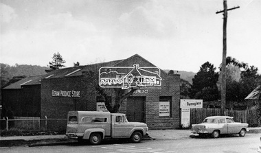 Eltham District Historical Society Inc
Photograph, Eltham Produce Store, ca 1960
Two vehicles including a Holden FC Special Sedan and ca 1958 Ford 100 truck are parked outside the Eltham Produce Store, Main Road, Eltham near Arthur Street. The brick building has signage to promote Tanox Paint and Permoglaze products. It also sold hay and grain. Operated by John McLean and Son. Situated just south from opposite Arthur Street, opposite the Eltham Village Shopping Centre. To the right was Garnet Burgess' second hand scrap metal and bottles, then the blacksmith shop, which was later taken over by Garnet with second hand furniture and next door to that was Ray Staff's grocery store. The store was demolished by 1963 for the BP Evergreen Service Station. See also: Cross Ref 00161 (print) and 01831-15 (negative duplicate) and SEPP_0785, See 00161, 01831-15, 01895-21This photo forms part of a collection of photographs gathered by the Shire of Eltham for their centenary project book, "Pioneers and Painters: 100 years of the Shire of Eltham" by Alan Marshall (1971). The collection of over 500 images is held in partnership between Eltham District Historical Society and Yarra Plenty Regional Library (Eltham Library) and is now formally known as 'The Shire of Eltham Pioneers Photograph Collection.' It is significant in being the first community sourced collection representing the places and people of the Shire's first one hundred years.Digital image. Copy of original photograph.sepp, shire of eltham pioneers photograph collection, eltham, eltham produce store, main road, tanox paint, permoglaze, holden fc special sedan, ford 100 truck -
 Federation University Historical Collection
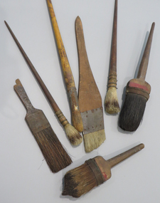
Tool - Brushes, Keith Rash's Sign writing Brushes
Commercial artist, Keith Edwin Rash (1910-1985), studied at the Ballarat Technical Art School between 1923 and 1929. These artefacts are from his professional practice. Sign writing and ticket-writing bridged art and trade, with hand lettering applied to long-term signage and short-term promotional materials. At the Ballarat Technical Art School, sign writing, ticket writing, and house decoration were overseen by Thomas Raisbeck (1884-1970) from 1915. Classes were then successively taught by former students William Kenneth (Ken) Moss (1889-1921) from 1920 until his untimely death, Albert E. Williams (1899-1986) until 1928, followed by experienced, practising sign writer, Charles Emrys (Angus) Henderson (1899-1976), who had trained under Raisbeck. A number of brushes and sponges used by Ballarat sign writer, Keith Rash, who studied sign writing at the Ballarat School of Mines. signwriting, keith rash, ballarat school of mines, brushes, ballarat technical art school, sign writing, ticket writing