Showing 309 items matching "tourist attractions"
-
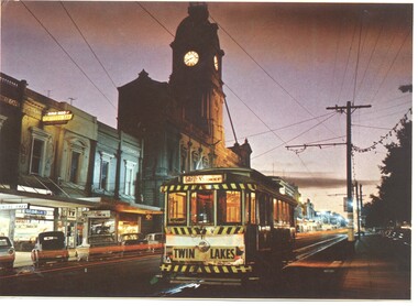 Ballarat Tramway Museum
Photograph - Illustration/s, Ballarat 11 with Town Hall
... photograph and a Ballarat tourist attraction at the time - the shell ...Illustration that yields information about a Ballarat tram and streetscape mid 1960's - evening photograph and a Ballarat tourist attraction at the time - the shell house.Illustrator with a printed photograph of Ballarat tram No. 11 at dusk in Sturt St, just west of Lydiard St. with Town Hall in background. Tram has destination of "GARDENS via Drummond Nth", with a "TWIN LAKES" sign on rear driver's apron of tram. On pole in front of tram is tram stop sign and a section sign. Pole painted with tram stop sign as well. On rear , printed in dark green ink is the card details etc. "Ballarat, Victoria, Looking to the City Hall, Sturt Street at sunset." See also Reg Item 669 - Nucolorvue car, BT 65 for the same photographs. On rear is a photo of the crown at the Shell house - see also Reg Item 2143 and 3079 for the same photograph. Possibly cut from a Nu-colour-vue publication.trams, tramways, sturt st, town hall -
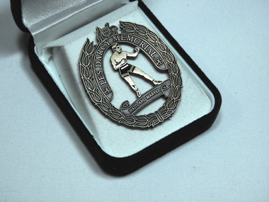 Athletics Victoria
Badge, Les Darcy Memorial
... Maitland cemetary where hundreds of tourists make visits every year ...This item is of significance because it commemorates the unveiling of a life size bronze statue of Australian middleweight boxing champion Les Darcy at Maitland, NSW. This limited edition badge was given as a memento to the sponsor's of the monument and special guests who attended the unveiling. It has historic relevance because Les Darcy was born at Stradbroke near Maitland in 1895. He died in America in 1917 age 22 and is buried in the West Maitland cemetary where hundreds of tourists make visits every year. His family home in Maitland still stands and is also a tourist attraction although privately owned. The badge depicts an image of Les Darcy in his famous boxing pose.The figure of Darcy is surrounded by a floral motif depicting the Australian coat of arms at the top and the inscription Les Darcy Memorial encircling his image. A scroll at the bottom of of the medal says; Maitland Wonder.badge, les darcy, boxiing, sport, memorial, maitland, nsw. -
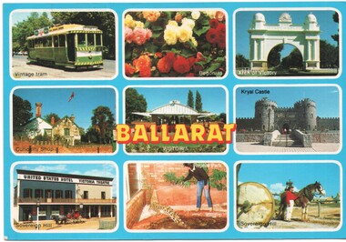 Ballarat Tramway Museum
Postcard - Ballarat 9 views - Rose Stereograph, Rose Stereograph Co, early 1980s
... panel of 9 images of Ballarat Tourist locations - Ballarat Trams ...Postcard containing a 3 x 3 panel of 9 images of Ballarat Tourist locations - Ballarat Trams featuring tram 27 in the later SEC Colour scheme, Begonias, Arch of Victory, Curiosity Shop, Gardens hot house, Kryal Castle, Sovereign Hill and the Reptile Park. Produced by Rose Stereograph Co. of Glen Waverly, No. 1679. Tram 27 was repainted in an early SEC Colours during 1984.Yields information about Ballarat tourist attractions during the early 1980s.Postcard - plain edges, divided back, 9 images of Ballarat Tourist locations.ballarat, trams, tramcars, btps, tourism, tram 27, gardens -
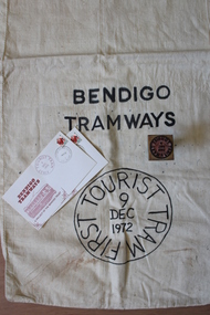 Bendigo Tramways (managed by the Bendigo Heritage Attractions)
Mail Bag, 1972
These items signify the launch of the Vintage Talking Tram tourist project by The Bendigo Trust for Bendigo Tramways.Calico mail bag, rubber stamp and stamped envelopes. mail bag: Bendigo Tramways First Tourist Tram 9 Dec 1972 rubber stamp: Bendigo Tramways First Tourist Tram 9 Dec 1972 envelopes: Bendigo Tramways First Tourist Tram 9 Dec 1972 -
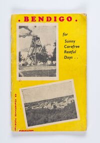 City of Greater Bendigo - Civic Collection
Booklet, Co-operative Press, Bendigo for Sunny Carefree Restful Days, 1947
A promotional publication to attract and encourage tourism to the district. Includes information about geographic location, climate and attractions. Businesses advertising is very eclectic and includes fashion houses, breweries, cafes and the School of Mines and Industry.Thirty six booklet promoting popular sites, events and businesses in Bendigo. Printed in three colour. Right hand page has the slogan BENDIGO "For That Dreamed - of Holiday" with images and text. Left page has full and half page advertisements for businesses, buildings and events.Bendigo / For / Sunny / Carefree / Restful / Days .../ An Australian Tourist / Publicationcity of greater bendigo commerce, city of greater bendigo events, city of greater bendigo tourism, making a nation -
 Canterbury History Group
Book, James Nicolas, The mystery of Fairyland, Kew, 2017
... Gallipoli veteran husband Jim had made their home a tourist ..."In 1965 in Kew, Melbourne, 88-year-old Grace Tabulo passed away at her 1860's home, Fairyland. This ended more than 20 years that Grace and her Gallipoli veteran husband Jim had made their home a tourist attraction for children in the local area and beyond. With exhibits, stories, concerts and celebrations for events like Empire Day, Fairyland was featured in newspapers and magazines in Melbourne and abroad. It was a unique place in a more innocent time that had a profound effect on all those who went there. What motivated this couple to dedicate their lives to their community? And what are some of the mysteries that lie behind this story? This is a window into post-war Melbourne suburbia which celebrates a wonderful couple and their lives' work. " (source: TroveBook which researchs the story of Grace and Jim Tabulo and their 1860's home, Fairyland in Kew. Includes photographs and Appendix with some entries from the visitors book. 109 pagesnon-fiction"In 1965 in Kew, Melbourne, 88-year-old Grace Tabulo passed away at her 1860's home, Fairyland. This ended more than 20 years that Grace and her Gallipoli veteran husband Jim had made their home a tourist attraction for children in the local area and beyond. With exhibits, stories, concerts and celebrations for events like Empire Day, Fairyland was featured in newspapers and magazines in Melbourne and abroad. It was a unique place in a more innocent time that had a profound effect on all those who went there. What motivated this couple to dedicate their lives to their community? And what are some of the mysteries that lie behind this story? This is a window into post-war Melbourne suburbia which celebrates a wonderful couple and their lives' work. " (source: Trovegrace tabulo, fairyland cottage, social life -
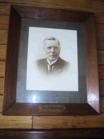 Parks Victoria - Mount Buffalo Chalet
Photograph, " DR J.F.WILKINSON"
'There are also a number of framed portraits, including those of...Dr. John Wilkinson, a doctor who started a practise in Bright in the late 1880's and helped develop the tourist potential of the Mount Buffalo Plateau. " (Pg 84, Historica, 2011) Dr John .F. Wilkinson was a significant figure in the pioneering of tourism at Mt Buffalo. A Doctor and resident of Bright, he and W.A. Staker were the founder members of the Bright Alpine Club formed in 1887 to promote the natural attractions of the Buffalo plateau. " They form the Alpine Club and charge a membership fee for guiding people up the mountain (led by official guides Bill Weston and Edward Carlisle). this is matched by a grant from the local shire council.... They advertise in the Argus and promote the Australian Alps, Bright district as "The Switzerland of Victoria'. Mt Buffalo, with the railways nearby, is the most accessible snowfield and becomes 'the cradle of skiing in Victoria'." (Pg 179 Historica . 2011) The initial funds raised by the Alpine club funded the Staker's walking track, the first easily accessible route up the mountain. . They engaged the services of early Victorian photographer Nicholas Caire, whose scenic photographs helped to promote the beauty of the mountain. The efforts of these gentlemen culminated in securing 2.800 acres for the one of the first National Parks in Victoria, 1898. Listed in Draft Inventory of significant Items. Framed sepia photograph. Grey mount in wooden frame. Portrait of Dr.J.F Wilkinson. Brass name plaque at base of frame. Hand finished / highlighted in places." DR J.F.WILKINSON" -
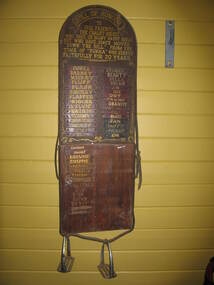 Parks Victoria - Mount Buffalo Chalet
Honour Board
Was located in the stables at Mount Buffalo Chalet. It was used to record the names of horses that were ridden by Chalet guests when they were holidaying at the Chalet. 'Admiring the rugged beauty of the Buffalo Plateau and exploring its scenic attractions ...quickly became part of the Mount Buffalo Chalet tourist experience...The Chalet facilitated the experience by hosting guided tours, including trail rides on horseback...the horses remained at the Chalet for decades, and have been remembered with great affection, as demonstrated by the honour roll for Chalet horses and various commemorative plaques.' (Pg 98. Historica) Many of these horses are still remmbered by former guest of the Chalet. Granite and Punka were legendary and plaques in their honor are mounted on the large granite boulders in the stableyards.Listed in Draft Inventory of Significant Collection items. Appendix A.3, Snow sports equipment and other recreational items. (Pg 166 Historica).Wooden plaque with names painted onto strips of leather fixed to a board. The board is made of two sections of wood and is arched at the top and squared at the base. The piece at the top that appears to be earlier and has gold painted inscriptions with decorative scrolling around the edge. The board has leather strapping around the edge and two stirrups threaded onto leather at the base. The upper section of the board has all the names painted onto leather strips. The lower section of the board has some names painted onto strips but also some names are scratched directly onto the wood.At top of plaque, "ROLL OF HONOUR /TO / OUR FRIENDS - / THE CHALET HORSES, / WHO GAVE US MANY HAPPY HOURS / BUT WHO HAVE SINCE MOVED / "DOWN THE HILL". FROM THE / TIME OF "PUNKA" / WHO SERVED / FAITHFULLY FOR 20 YEARS" Underneat this are the names of the individual horses starting with , "PUNKA....." -
Friends of Ballarat Botanical Gardens History Group
Work on paper - Lindsay Gordon's Cottage, Ballarat Courier 15 August, 1934, 15 August 1934
... a tourist attraction. Adam Lindsay Gordon Adam Lindsay Gordon ...The Australian poet Lindsay Gordon had a strong following in Ballarat half a century ago.The cottage where Gordon lived was once the sample room at Craig's Hotel and by renovating and moving it to the Ballarat Botanical Gardens, it was hoped that it would become a tourist attraction.2 pages of newspaper print with one column relevant to Gordon on each page.In the top lefthand corner of p.1 15 August 1934 is written in blue biro.adam lindsay gordon, adam lindsay gordon cottage, lindsay gordon's cottage, craig's hotel, poet, ballarat botanical gardens, john garner, doctor, john garner collection, craft cottage, brighton cemetery, "the sick stockrider"., westminster abbey, livery stables 1867-1868, gardens, ballarat -
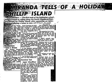 Phillip Island Conservation Society Inc.
Work on paper - Photocopy of newspaper cutting, Herald and Weekly times, "MIRANDA TELLS OF A HOLIDAY ON/ PHILLIP ISLAND"
... than man- made tourist attractions, which is also significant ...Miranda was a very popular journalist of this era, whose homely style appealed to many readers, especially women, her main audience in her writing. Here she talks about renting a new demonstration holiday home (probably a Coldon Home), which, although small, had a 'dream kitchen'. She describes the birds and walk through the wattle to the beach, but also the many blocks for sale and wonders what the island will be like in 10 years time from their visit. Her son drove them to Pyramid Rock where they almost got bogged on the road. They visit the usual spots, which she describes with a combination of curiosity and enjoyment. She also mentions another block fenced off on the main road which was a gift from the ratepayers of Phillip Island, and which the Young Farmers were to plant out for koala trees.This article is significant because thousands of Weekly Times newspaper readers read Miranda’s letter article without fail each edition. She describes renting a house for a holiday, which indicates the move away from family holidays in guest houses. She also describes some of the rough roads in parts of the island at the time. She concentrates on the island’s natural attractions rather than man- made tourist attractions, which is also significant in letting us see why people would visit Phillip Island in that era. Miranda also predicts the explosion of the holiday home owner market which took place soon after, and continues today though in a more controlled way.Photocopy of newspaper article cut out from full page. Cutting has three columns of text, no images. Black text on white paper. Dark areas due to poor photocopyingWEEKLY TIMES / 2/9/65phillip island, miranda, weekly times newspaper, holiday home, phillip island flora and fauna, pyramid rock, phillip island pengiun parade, young farmers, phillip island beaches, cuddly koala bears, phillip island housing estate land sales -
 Phillip Island Conservation Society Inc.
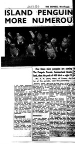
Work on paper - Photocopy of newspaper cutting, The Express, "ISLAND PENGUINS/MORE NUMEROUS", 20/01/1966
... Tourist attraction.... Tourist attraction. A H Bert West souvenirs Little Penguin ...Article written in Wonthaggi newspaper giving up to date information about facilities, visitation and numbers of Little Penguins at the Phillip Island Penguin Parade in 1966.The information in the article is a very valuable record of the population of the penguins, (small compared with 2023); the huge numbers of visitors permitted per night - 10,000 compared with maximum of about 2,500 per night 2023; facilities available then and how funded.photocopy cutting of newspaper article. 4 columns text but right hand column cut in half. large photo of penguins above text. Poor photocopy20/1/66phillip island, phillip island penguin parade, tourist attraction., a h bert west, souvenirs, little penguin behaviour -
 Ballarat Tramway Museum
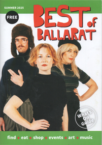
Book, Scott Bain, "Best of Ballarat", Nov. 2024
... information about tourist attractions etc in Ballarat. Trams tramways ...Gives details of events, locations, hotels, food etc - a What's on in Ballarat. Advertisement for BTM on page 24 features Geelong 2 in the New Museum. See page 24 for the BTM entry.Yields information about tourist attractions etc in Ballarat.Book - 52 pages, centre stapled, full colour, titled "Best of Ballarat", for Summer 2025. trams, tramways, ballarat, btm, events, hotels, tram 2 -
 Flagstaff Hill Maritime Museum and Village
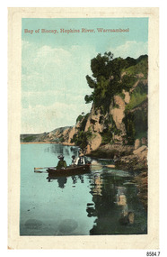
Postcard - Scenic - Warrnambool, Bay of Biscay, Hopkins River, Warrnambool, 1902-1910
... as a tourist attraction at a time when ships called coastal traders ...The nine postcards in this set were donated together and date to the early 1900s. All but one postcard in this set shows images of Warrnambool, in the Western District of Victoria; the other has a London image. The postcards were all printed in Great Britain according to that country’s postal regulations. The fronts of all cards have titles printed in red. Most of the images on the cards are attributed to photographer Joseph Jordan and belong to the Jordan Series. The back of these cards has an outline for a postage stamp, a vertical dividing line and a heading on each side of the line to separate the Correspondence from the Address. Postcards or ‘correspondence cards’ appeared in Britain in 1894. They were plain cards with a space for the message on one side and an address on the other; regulations didn’t allow anything but the address to be written on the ‘address’ side. In 1902 the British regulations then allowed a picture to be printed on the front and the address on the back, so messages had to be written on the picture side. Soon, the regulations changed and the back was divided for a message and the address. Bay of Biscay, Hopkins River, Warrnambool – This same image was published in Table Talk on January 6th, 1910 and in The Age, on December 18, 1929, referred to a revival of fishing at the Bay of Biscay on the Hopkins River. These and similar articles showcased the Bay of Biscay as a popular boating and fishing location and well worth promoting to places outside of Warrnambool. Joseph Jordan - Joseph Jordan was born in 1841 in Leicester England. When he was 16 he joined the 7th Queen's Own Hussars and was sent to India at the outbreak of the mutiny. He took part in the relief of Lucknow and remained in India for eleven years. It was during this time that he became interested in photography. He was posted to New Zealand and later came to Victoria, becoming a sergeant major of the Mounted Rifles. In the mid-1880s he came to the Western district where he was responsible for establishing units of the Mounted Rifles in various country towns such as Dunkeld, Mortlake, Panmure, Bushfield, Koroit etc. He resigned from the army in 1889 and set up a professional photography studio in Liebig Street, Warrnambool. He became very well known in the Western District for family photographs, official photographs of local councillors and groups as well as views of local scenery. In 1891 he photographed the wrecked barque ‘Fiji’ at ‘Wrecks Beach’ near Princetown. His business was taken over by his son Arthur around 1917. Joseph was a keen rifle shot and in 1924 he donated the "Jordan Shield" as a prize to the Victorian Rifle Association. He was made a "Life Honorary Member" of the Warrnambool Returned Soldiers League and in 1933 he was recognised as being the oldest living soldier in Victoria. Joseph died in 1935 aged 95.The image of the figures in a row boat on the river suggests that the location was a popular place to visit. The choice of subject for this postcard indicates the popularity of Warrnambool's natural environment as a tourist attraction at a time when ships called coastal traders brought passengers and cargo to the Port of Warrnambool from ports along Victoria's southwest coast. Joseph Jordan is a significant figure in Warrnambool history as he helped to establish early units of the Mounted Rifles (G Company) in local towns during the late 1880's and later, photographed local scenes, groups and citizens of early Warrnambool.Postcard, one of nine, portrait orientation, coloured print within a rectangle border with an impressed line around the image and a title in red. The picture shows three figures wearing hats in a rowboat on the bank of a river beside cliffs. There is no correspondence written on the card. The back has inscriptions and outlines for a postage stamp. Jordan Series, printed in Great Britain.Front, in red: “Bay of Biscay, Hopkins River, Warrnambool” Back in green: “Jordan Series” “POST CARD” “PRINTED IN GREAT BRITAIN” “For correspondence” “The Address only to be written here”flagstaff hill maritime museum, flagstaff hill maritime village, flagstaff hill maritime museum and village, maritime museum, warrnambool, great ocean road, warrnambool and district, warrnambool scenes, local scenes, views of warrnambool, joseph jordan, jordan series, jordan photography, postcard, souvenir, correspondence, cameo postcard, bay of biscay, fishing, boating -
 Bendigo Historical Society Inc.
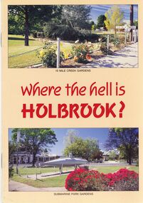
Book - STRAUCH COLLECTION: WHERE THE HELL IS HOLBROOK
BHS CollectionWher the hell is Holbrook ? A tourist guide to Holbrook showing attractions and services. -
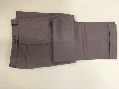 Warrnambool and District Historical Society Inc.
Pants, Fletcher Jones, Mid 20th century
... are still maintained today and are a tourist attraction in the city ...These trousers have been made by Fletcher Jones and Staff. This business was established by David Fletcher Jones (1895-1977) in 1924 when he leased three shops in Liebig Street, Warrnambool. In 1928 he moved his business to the main retailing area near the Liebig Street/Koroit Street intersection. In 1931 a shop built to Fletcher Jones’ requirements was erected and by 1938 he had a staff of 40. By 1945 FJ trousers were sold in 123 stores in Victoria and in 1948 the Fletcher Jones factory was established in Flaxman Street Warrnambool, officially named Pleasant Hill. In 1951 the company became Fletcher Jones and Staff and by the mid 1970s the staff had 75% ownership. By this time FJ and Staff had become one of the largest clothing manufacturers in Australia with 55 shops and almost 3000 employees. The range of clothing was enlarged to include both men’s and women’s wear. In the 1980s, after the death of Fletcher Jones, the abolition of import tariffs and the availability of cheap imported clothing caused the Fletcher Jones Company to decline and to be sold to a Geelong company. By 2011 all Fletcher Jones shops had closed. These trousers are of great interest as they are a product of a Warrnambool business that was nationally and internationally known in the 20th century for its quality men’s wear, especially the Coverdine brand trousers. The Fletcher Jones business remains one of the most important businesses, (if not the most important), that ever existed in Warrnambool. It employed a great number of local people in the second half of the 20th century, and is remembered with great fondness by many people in the city and surrounds today. The Fletcher Jones Gardens at the Factory site are still maintained today and are a tourist attraction in the city. These are a pair of brown Fletcher Jones trousers made of Coverdine material (87.5% wool with nylon). There is some lining around the waist area and the legs are turned up at the end with some leather binding inside the bottom legs. The waist band is stiffened and is fastened with a metal clip and two buttons. The waist band has two adjustable areas using tabs and two buttons each side. The back pockets also have buttons.fletcher jones and staff, coverdine fletcher jones trousers, history of warrnambool, david fletcher jones -
 Warrnambool and District Historical Society Inc.
Booklet - Booklet Collection: City of Warrnambool Tourist Guides, Collett, Bain and Gaspar, Warrnambool
This is a collection of sixteen tourist guides dating from the mid 1970's to 2013. These contain listings of businesses, accommodation, eateries and events in Warrnambool and district. They also include maps of Warrnambool and surrounds, advertising and photographs of various attractions. While mainly covering Warrnambool a small number of the guides cover the South West Region. These directories have mainly been published by the Warrnambool City Council and are a selection of the types of information provided to visitors at the Tourist information centre during this time period.These tourist guides give snapshots of the City of Warrnambool for the years covered and will be useful for research.[.1] An 8 page paper booklet with black printing and a black & white photo of the pond at the Botanical Gardens on the front cover. [.2] two photocopied A4 black and white pages from the book "On the Trail" K Winser 1956 (Main Roads of Australia) [.3] A trifold colour brochure with a stylised map of the coast on the yellow and blue front cover. The inside has stylised colour drawings on Warrnambool attractions. The rear cover has coloured photographs of bush, Liebig Street and Fletcher Jones gardens [.4] A trifold black and white brochure with a black line drawing of a whale on the front cover. [.5] A trifold white card with mauve printing. The front cover has a line drawing of the former Timor Street post office and a map of businesses and landmarks in Timor Street. The reverse side contains a brief history of Warrnambool. [.6] A 98 page stapled booklet with a foreword by Vanda Savill. There are 4 pages of coloured photographs. The remainder are black and white photographs. The front cover is purple with white writing in the lower third. There is an outline of the coast and five colour photographs of district attractions. The inside middle page has a map of the Western wonderland region. The content covers towns in this area. Content relating to Warrnambool is in the last six pages. [.7] Twelve loose photocopied black and white pages. The front cover has the Warrnambool Premier Town 1988-1991 logo and a photo of a Southern Right Whale and calf. The bottom right hand corner has a Standard Warrnambool logo. [.8] 44 page booklet printed with blue ink. The staples have been removed. The glossy front cover has blue printing with a coloured photo of Flagstaff Hill Maritime Village pond. The centre pages has a fold out map of the City of Warrnambool. The rear cover has photos of The Twelve Apostles and Hopkins Falls. [.9] 4 loose photocopied pages with Warrnambool Library and Corangamite Regional Library Service Warrnambool City Library black ink stamps. The front page line drawing illustrations of Warrnambool attractions [.10] A single sheet of glossy white paper folded in half to make four pages. The front page has a Warrnambool premier town logo 1979-1982 and blue printing and a visitor survey. [.11] A conference pack of light card folded to make a pocket containing three brochures, a shipwreck coast tourist directory and a Australian Heritage Parks Association conference program dated 24 to 27 May 1992. The front cover of the pack has green writing over a stylised upward arrow. There is a City of Warrnambool logo in the top right hand corner and two film strips diagonally across the cover containing photographs of Warrnambool. The rear cover has a coloured Warrnambool Premier Town logo. [.12] A 63 page stapled booklet with coloured photographs of Warrnambool. The front cover has black writing on white background. There is a coloured photograph of Flagstaff Hill in the middle of the cover and a Warrnambool City and Visit Victoria logos on the lower edge. The middle pages has a coloured of the city of Warrnambool with an inset map of Allansford. [.13] A single large sheet of white paper folded in ten to make a brochure. The front cover has black printing. The rear cover has a purple ink stamp for the City of Warrnambool Tourist Information Centre. When folded out the reverse side has a green, grey and white map of the South West Region of Victoria. [.14] A 48 page colour booklet on glossy paper. The front cover has white writing on a blue background and includes photographs of the Twelve Apostles, the Promenade walk, Flagstaff Hill and a southern right whale's tail. The rear cover has photographs of The Twelve apostles, a passenger train from Melbourne passing the Lake Pertobe playground, and a rural scene. There is white writing and a white Warrnambool City logo on a blue background. The centre pages have a stylised green and blue map of the city of Warrnambool. [.15] A 48 page colour booklet on glossy paper. The front cover has white writing over colour photographs of two people at a lookout, Flagstaff Hill, three southern right whales and a child at the Lake Pertobe playground. The lower edge has blue upper case writing on a white background. The rear cover has a colour photograph of the Twelve Apostles. The lower white border on the rear covers has a a blue and green City of Warrnambool logo and blue writing. The centre pages have a stylised green and blue map of the city of Warrnambool. [.16] A 64 page colour booklet on glossy paper. The front cover has black writing on a black background and there is a photograph of a southern right whale's tail. The lower edge has the Warrnambool City and Visit Victoria Logos. The centre pages have maps of Warrnambool and surrounds. [.1] This week in Warrnambool Vol 2 No. 5 Thurs 1st Feb. For the time of your life [.2] Warrnambool Way [.3] Warrnambool The Holiday Host on the South West Coast with compliments City of Warrnambool and Warrnambool Chamber of Commerce [.4] MMI Insurance presents Whales Giants of the Deep Whale Watcher's Logbook Warrnambool [.5] Warrnambool History began in Timor Street [.6] Western Wonderland Tourist Association [.7] A Premier Arrow Tour of Warrnambool Victoria's Premier Town Australia's Southern Right Whale Nursery [.8] Warrnambool The Heart of Victoria's Great Southwest Visitor's Handbook [.9] What to see in Warrnambool Victoria's Premier City 1979-1982 [.10] Win a Free Holiday & $200 Cash in Victoria's Premier Town [.11] Advancing Warrnambool together! [.12] Great Ocean Road Warrnambool Official Visitor Guide [.13] Tourist guide to the South West Region Victoria All it needs is you [.14] Warrnambool visitor guide 2005 the great ocean road experience attractions accommodation entertainment dining [.15] Warrnambool Visitor Guide 2006 the great ocean road experience Attractions Accommodation Entertainment Dining [.16] Official Visitors' Guide Warrnambool Victoria Australia Discover the Great Ocean Road warrnambool, warrnambool tourist guides -
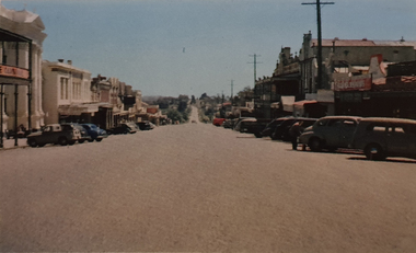 Ballarat Heritage Services
Photograph, Nucolorvue, Vincent Street Daylesford Looking Towards Hepburn Springs, 1957
Daylesford is a tourist town in Central Victorian, known for its mineral water springs.Vincent Street Daylesford Looking Towards Hepburn SpringsDaylesford, Victoria, Australia This famous holiday resort is famous for its up-to-date facilities, as well as for its natural attractions. The mineral Springs are renowned for their high medicinal elements. The visitor finds ample to amuse, in excellent fishing, boating, Boating, Swimming, golfing, hiking and riding. The district provides a wide range of typical Australian bush scenery, and the altitude of 2,000 feet above sea level as a tonic effect on all. Daylesford has modern hotels, guest houses, shops and places of amusement, also many other places of interest within short travelling distance. Bendigo, 50 miles, Ballara 30 miles, and Melbourne 75 miles, bring Daylesford within easy reach of many parts of Victoria. daylesford, vincent street, streetscape -
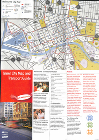 Melbourne Tram Museum
Map, City of Melbourne, "Inner City Transport Map", c1990
Map - 6 fold DL - full colour titled "Inner City Transport Map", providing information for Tourist Information centres, Metlink. Melbourne City Tourist Shuttle, and two maps, one provided by Melway giving a list of attractions. Published by City of Melbourne, Melway and Metlink with each of their logos.trams, tramways, map, public transport, city of melbourne, metlink -
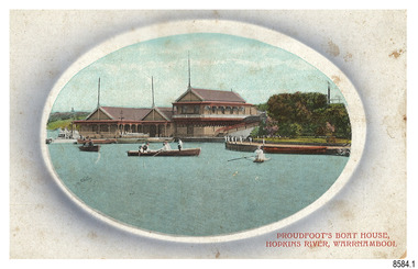 Flagstaff Hill Maritime Museum and Village
Postcard - Historical, Warrnambool, Proudfoot’s Boat House, Hopkins River, Warrnambool, Early 20th century
... Boathouse is an example of late-Victorian recreational and tourist ...The nine postcards in this set were donated together and date to the early 1900s. All but one postcard in this set shows images of Warrnambool, in the Western District of Victoria; the other has a London image. The postcards were all printed in Great Britain according to that country’s postal regulations. All cards have titles on the front printed in red. The majority of the images on the cards are attributed to photographer Joseph Jordan and belong to the Jordan Series. The back of these cards has an outline for a postage stamp, a vertical dividing line and a heading on each side of the line to separate the Correspondence from the Address. Postcards or ‘correspondence cards’ appeared in Britain in 1894. They were plain cards with a space for the message on one side and an address on the other; regulations didn’t allow anything but the address to be written on the ‘address’ side. In 1902 the British regulations then allowed a picture to be printed on the front and the address on the back, so messages had to be written on the picture side. Soon, the regulations changed and the back was divided for a message and the address. Proudfoots Boat House – Proudfoot’s Boathouse is at 2 Simpson Street Warrnambool, on the banks of the Hopkins River. In the 1880s it was a venue for hiring boats for rowing, fishing, sailing and picnics. It was a popular destination for tourists coming from Melbourne for a day or weekend outing. The beautiful historic Victorian period building was designed, built and established by Thomas Proudfoot. He applied to build a boat jetty in 1885. He died in 1900 and his wife Catherine took over, running it for many years. Later her son Bruce and after that her granddaughter Ena Hunt and her husband took over; it remained in the family until 1979. The buildings, including the ‘U’ shaped jetty and tearooms, were restored and modified in the 1990s by the Warrnambool Sports Club, under the control of the Warrnambool City Council. Joseph Jordan - Joseph Jordan was born in 1841 in Leicester England. When he was 16 he joined the 7th Queen's Own Hussars and was sent to India at the outbreak of the mutiny. He took part in the relief of Lucknow and remained in India for eleven years. It was during this time, he became interested in photography. He was posted to New Zealand and later came to Victoria, becoming a sergeant major of the Mounted Rifles. In the mid-1880s he came to the Western district where he was responsible for establishing units of the Mounted Rifles in various country towns such as Dunkeld, Mortlake, Panmure, Bushfield, Koroit etc. He resigned from the army in 1889 and set up a professional photography studio in Liebig Street, Warrnambool. He became very well known in the Western District for family photographs, official photographs of local councillors and groups as well as views of local scenery. In 1891 he photographed the wrecked barque ‘Fiji’ at ‘Wrecks Beach’ near Princetown. His business was taken over by his son Arthur around 1917. Joseph was a keen rifle shot and in 1924 he donated the "Jordan Shield" as a prize to the Victorian Rifle Association. He was made a "Life Honorary Member" of the Warrnambool Returned Soldiers League and in 1933 he was recognised as being the oldest living soldier in Victoria. Joseph died in 1935 aged 95.This card is the only one of the nine cards with the location of Warrnambool added to the name 'Joseph Series'. It is also the only one that has text within the outline for the postage stamp. The font used for the test of the headings is slightly different to the other cards. Joseph Jordan is a significant figure in Warrnambool history as he helped to establish early units of the Mounted Rifles (G Company) in local towns during the late 1880's and later, photographed local scenes, groups and citizens of early Warrnambool. This postcard of Proudfoot's Boathouse is of historical significance for is connection with Proudfood’s Boathouse. Proudfoot’s Boathouse is an example of late-Victorian recreational and tourist facilities. Boathouses were popular 19th-century tourist and recreational attractions, providing refined and healthy activity. This boathouse shows the early realisation of the tourism and leisure potential of seaside towns such as Warrnambool, a potential that has become increasingly important as port uses have ceased and other industries have been subjected to financial pressure. Proudfoot's Boathouse is of social significance because it illustrates the continuity of the attraction of this kind of leisure facility. Although the glory days of boathouses were in the 19th century, those that survive continue to be well patronised. Proudfoot's Boathouse has been an important recreational facility and attraction for tourists flocking to the Hopkins River, one of the State's most popular boating and fishing resorts, since 1885.” (Statement of Significance is from the Victorian Heritage Register)Postcard, one of nine, landscape orientation. Coloured photograph print within an oval border and mauve-toned shading. Cameo Image of figures in three rowing boats on still water beside a building with three gable roofs and decorative verandas. Other boats are moored at the landing in front of the building. The roofs each have a tall pole at the front. There is a park right of the building that also has a landing. In the background is a grassed slope and the sea. Reverse has printed inscriptions and an outline for a postage stamp. There is no correspondence written on the card. The card is one of the Jordan Series by Joseph Jordan, printed in Great Britain in the early 1900s. Front, in red: “PROUDFOOT’S BOAT HOUSE / HOPKINS RIVER, WARRNAMBOOL” Reverse in black: “Jordan Series Warrnambool” “POST CARD” “Printed in Great Britain” “This space may be used for Communication” “The Address to be written here” Within the stamp outline: “3 / BRITISH / MANUFACTURE"flagstaff hill maritime museum, flagstaff hill maritime village, flagstaff hill maritime museum and village, maritime museum, warrnambool, great ocean road, warrnambool and district, warrnambool scenes, local scenes, views of warrnambool, joseph jordan, jordan series, jordan photography, postcard, souvenir, correspondence, cameo postcard, landscape, proudfoots boat house, boat house, proudfoots, hopkins river, boats for hire, row boats, recreation -
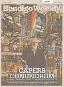 Bendigo Historical Society Inc.
Newspaper - Article on Bendigo Tourist attraction 'Confectionary Capers', June 04 2022
... Article on Bendigo Tourist attraction 'Confectionary Capers'...tourist attraction.... Newspaper Article on Bendigo Tourist attraction 'Confectionary ...Campbell Smith had the passion to share his fascination with 18th century applied mechanic and extol the wonders of the industrial revolution. He set up Confectionary Capers in a shed on the highway at Junertoun in 1994.Bendigo Advertiser article entitled 'Capers Conundrum' Front page and inner full-page article with colour photos.bendigo, confectionary capers, tourist attraction, campbell smith -
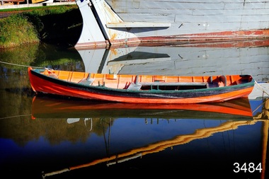 Flagstaff Hill Maritime Museum and Village
Vehicle - Vessel, Dinghy, Proudfoot's Boat, c. 1885
... and tourist facilities. Boathouses were popular 19th-century tourist ...This boat or dinghy is one of a few remaining boats made for Proudfoot’s Boathouse, 2 Simpson Street Warrnambool, on the Hopkins River, in about 1885. It was one of many rowing, fishing, sailing and picnic boats that were available to hire. Proudfoot’s Boathouse, a beautiful Victorian Period building, was designed, built and established by Thomas Proudfoot. He applied to build a boat jetty in 1885. He died in 1900 and his wife Catherine took over, running it for many years. Later her son Bruce and after that her granddaughter Ena Hunt and her husband took over; it remained in the family until 1979. Proudfoot’s was a very popular tourist destination for visitors coming from Melbourne to fish and row and enjoy afternoon tea. The buildings, including the ‘U’ shaped jetty and tearooms, were restored and modified in the 1990s by the Warrnambool Sports Club, under the control of the Warrnambool City Council. The dinghy was brought to Flagstaff Hill in about 1992 and restored to its original condition and painted in traditional paint colours of orange with dark green gunnel and black and gold pinstripes. Since that time it has been painted by Flagstaff Hill's boatbuilder.This dinghy, Proudfoot’s Boat, is significant for its association with Proudfoot’s Boathouse, which is listed on the Victorian Heritage Register, VHR H0620. “Proudfoot's Boathouse on the Hopkins River near Warrnambool is an outstanding example of a late-19th century boathouse complex with associated residences and jetties. Thomas Proudfoot first applied for a jetty licence in 1885 with a view to establishing a boating business on the Hopkins River. The early single-storey sections are thought to date from this period. The two storey second stage probably dates from 1893 when additions were constructed. The entire complex was designed and built by Proudfoot himself. The business remained in the Proudfoot family until 1979. The buildings were modified in the 1990s in the process of creating a sporting club on the site. Proudfoot's Boathouse is of architectural, historical and social significance to the State of Victoria. Proudfoot's Boathouse is of architectural significance as perhaps the finest example of a 19th-century boathouse in Victoria. Although recent modifications have reduced the intactness of the buildings, many original features remain. The beautifully ornamented buildings still provide an attractive instance of 19th-century leisure facility architecture. Proudfoot's Boathouse is of historical significance as an example of late-Victorian recreational and tourist facilities. Boathouses were popular 19th-century tourist and recreational attractions, providing refined and healthy activity. This boathouse shows the early realisation of the tourism and leisure potential of seaside towns such as Warrnambool, a potential that has become increasingly important as port uses have ceased and other industries have been subjected to financial pressure. Proudfoot's Boathouse is of social significance because it illustrates the continuity of the attraction of this kind of leisure facility. Although the glory days of the boathouse were in the 19th century, those that survive continue to be well patronised. Proudfoot's Boathouse has been an important recreational facility and attraction for tourists flocking to the Hopkins River, one of the State's most popular boating and fishing resorts, since 1885.” (Statement of Significance is from the Victorian Heritage Register)Wooden vessel or boat, called a dinghy, known as Proudfoot’s Boat. Paint work is orange with dark green gunnel and black stripe. The rowboat is propelled by oars and has two pair of thole set into the gunnel (gunwale) to hold the oars in place and to serve as a fulcrum when rowing. The boat is dated around 1885. flagstaff hill, warrnambool, shipwrecked coast, flagstaff hill maritime museum, maritime museum, shipwreck coast, flagstaff hill maritime village, great ocean road, small marine vessel, dinghy, proudfoot's boat, proudfoot's boathouse, picnic boat, orange and black boat -
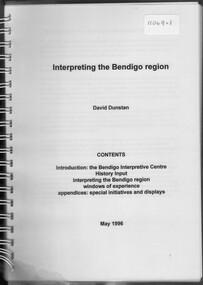 Bendigo Historical Society Inc.
Booklet - David Dunstan - Interpreting the Bendigo Region
Compilation of natural, historic and commercial attractions of the whole Bendigo RegionDavid Dunstan - Interpreting the Bendigo Region. The Bendigo Interpretive Centre will combine Technoloy and traditional display techniques with user-friendly on-line tourist information to provide easy access to information on the rich array of natural, historic and commercial attractions of the whole Bendigo Region.natural, historic and commercial attractions of the whole bendigo region -
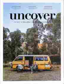 Ballarat Tramway Museum
Magazine, Roar Publishing, "Uncover Best of Ballarat & Western Victoria", May 2021
Magazine published at the time of the 2021 Ballarat Heritage Festival containing a photo of a youngster standing in the front of tram 39 wearing a cap and "driving" the tram, advert for Steamrail, and the calendar for the Ballarat Heritage Festival of May 2021. Includes articles on various attractions, companies, wineries, fashion, travel, and accommodation.Demonstrates a tourist promotion magazine.Magazine - 100 A4 pages, full colour, perfect bound.ballarat, btm, tram 39, ballarat tourism, tourism -
 Hymettus Cottage & Garden Ballarat
Functional object - Bookmark, Marineland of Australia
... Tourist Attraction... Queensland Marineland Aquarium Sea Life Bookmark Souvenir Tourist ...Marineland of Australia, was located on the Gold Coast, Queensland Australia operating from 1965, until 1976.gold coast, queensland, marineland, aquarium, sea life, bookmark, souvenir, tourist attraction -
 Wooragee Landcare Group
Photograph, circa April 2003
This photograph was taken in the Mount Pilot Chiltern National Park. It was taken during a search for the tiger quoll conducted by a team of volunteers from the Wooragee Landcare Group. The tiger quoll is also known as the spotted-tail quoll and is found in the national park. The 2003 bushfires caused worry for the safety of the tiger quoll, hence the need for a search for it. Mount Pilot Chiltern National Park is located near Chiltern in Victoria. It's most notable landmarks include Mt Pilot and Woolshed Falls. It also has many mines from the Gold Rush in the late 1800s. It is home to much flora and fauna, including the tiger quoll. The park is also home to the box-ironbark forest that once was present in most of north-eastern Victoria. The park is a large tourist destination as in there are many bushwalks and other attractions for visitors. In 2003, bushfires raged through Mount Pilot National Park and destroyed much of the environment. Some of this damage can be seen in the burnt trees in the picture. This photograph represents the work that goes into protecting a important species like the tiger quoll and there has been much work done to preserve it. This photograph was taken when the Wooragee Landcare group went to ensure the survival of this species, highlighting how the tiger quoll is being protected. This photograph also demonstrates the significance of Mount Pilot Chiltern National Park. The park has many special flora and fauna that can only be found in this area. For example, the box-ironbark forest and the tiger quoll. The forest used to stretch over much of north-eastern Victoria and is therefore reminiscent of what that area of Victoria was once like. This park is historical for this reason but it is also historical through it being once goldfields from the Gold Rush in the 1800s.Landscape coloured photograph printed on gloss paperReverse: WAN NA 0ANA2N0 NNN- 1 1636 / [PRINTED] (No.8) / 922mount pilot, mount pilot chiltern national park, chiltern, victoria, landmark, woolshed falls, gold rush, tiger quoll, flora, fauna, spotted tail quoll, marsupial, andy murray, andy murray quolls, carnivorous marsupial, forests, rainforests, coastal heathlands, woodlands, photograph, species, wooragee, wooragee landcare group, wooragee landcare, bushfires, identification, search, dna, droppings, box ironbark forest, ironbark, box iron bark -
 Bendigo Historical Society Inc.
Document - Black and white laminated photo of flow of water from Lake Eppalock. 1964
John Perry Collection. Laminated copy of photo of crowd watching flow of water from the opened valve at the wall of Lake Eppalock during its commissioning. March, 1964. Lake Eppalock was created by flooding to town of Wild Duck. The dam was built by the State Rivers and Water Supply Commission of Victoria. The dam wall height is 45 metres (148 ft) and the main embankment is 1,041 metres (3,415 ft) long. At 100% capacity the dam wall was designed to hold back 304,651 megalitres (6.7014×10¹⁰ imp gal; 8.0480×10¹⁰ US gal) of water. The surface area of Lake Eppalock is 3,011 hectares (7,440 acres) and the catchment area is 2,124 square kilometres (820 sq mi). The controlled spillway is capable of discharging 8,040 cubic metres per second (284,000 cu ft/s). Lake Eppalock supplies both stock and domestic water to the Campaspe irrigation district. It also serves as a water supply to Bendigo and Heathcote and, in more recent times, Ballarat. The lake is a major attraction for those engaging in watersports, with a number of tourist parks and accommodation facilities available. Permissible activities on the lake include high-speed boating, water skiing, sailing, canoeing, fishing and swimming. The lake's water levels were low for approximately eight years between 2002 and 2010 during a prolonged drought, which restricted the amount of recreational activity until rainfall in the latter half of 2010 returned the lake to 100 percent capacity. Built between 1961 and 1964, Lake Eppalock remains the only water storage on the Campaspe River system.water, dam, reservoir, eppalock, wild duck -
 Bendigo Historical Society Inc.
Map - Map of Lake Eppalock shoreline when empty
John Perry Collection. Laminated copy of map detailing Lake Eppalock shoreline when empty. Circa 1951. Has colored highlighter lines following roads leading to lake shoreline and various inundated old roads and tracks on lakebed. The dam was built by the State Rivers and Water Supply Commission of Victoria. The dam wall height is 45 metres (148 ft) and the main embankment is 1,041 metres (3,415 ft) long. At 100% capacity the dam wall was designed to hold back 304,651 megalitres (6.7014×10¹⁰ imp gal; 8.0480×10¹⁰ US gal) of water. The surface area of Lake Eppalock is 3,011 hectares (7,440 acres) and the catchment area is 2,124 square kilometres (820 sq mi). The controlled spillway is capable of discharging 8,040 cubic metres per second (284,000 cu ft/s). Lake Eppalock supplies both stock and domestic water to the Campaspe irrigation district. It also serves as a water supply to Bendigo and Heathcote and, in more recent times, Ballarat. The lake is a major attraction for those engaging in watersports, with a number of tourist parks and accommodation facilities available. Permissible activities on the lake include high-speed boating, water skiing, sailing, canoeing, fishing and swimming. The lake's water levels were low for approximately eight years between 2002 and 2010 during a prolonged drought, which restricted the amount of recreational activity until rainfall in the latter half of 2010 returned the lake to 100 percent capacity. Built between 1961 and 1964, Lake Eppalock remains the only water storage on the Campaspe River system.map, eppalock, reservoir, lake, water -
 Bendigo Historical Society Inc.
Map - Laminated map of Lake Eppalock at full capacity
John Perry Collection. Laminated copy of map of Lake Eppalock at full capacity. Had highlighter markings of old roads which appear to be still in use. The dam was built by the State Rivers and Water Supply Commission of Victoria. The dam wall height is 45 metres (148 ft) and the main embankment is 1,041 metres (3,415 ft) long. At 100% capacity the dam wall was designed to hold back 304,651 megalitres (6.7014×10¹⁰ imp gal; 8.0480×10¹⁰ US gal) of water. The surface area of Lake Eppalock is 3,011 hectares (7,440 acres) and the catchment area is 2,124 square kilometres (820 sq mi). The controlled spillway is capable of discharging 8,040 cubic metres per second (284,000 cu ft/s). Lake Eppalock supplies both stock and domestic water to the Campaspe irrigation district. It also serves as a water supply to Bendigo and Heathcote and, in more recent times, Ballarat. The lake is a major attraction for those engaging in watersports, with a number of tourist parks and accommodation facilities available. Permissible activities on the lake include high-speed boating, water skiing, sailing, canoeing, fishing and swimming. The lake's water levels were low for approximately eight years between 2002 and 2010 during a prolonged drought, which restricted the amount of recreational activity until rainfall in the latter half of 2010 returned the lake to 100 percent capacity. Built between 1961 and 1964, Lake Eppalock remains the only water storage on the Campaspe River system.map, water, dam, reservoir, eppalock -
 Bendigo Historical Society Inc.
Map - Laminated worksheet - identification of inundated artifacts at Lake Eppalock
John Perry Collection. Laminated copy of worksheet identifying inundated artifacts at Lake Eppalock when at 10% capacity. The dam was built by the State Rivers and Water Supply Commission of Victoria. The dam wall height is 45 metres (148 ft) and the main embankment is 1,041 metres (3,415 ft) long. At 100% capacity the dam wall was designed to hold back 304,651 megalitres (6.7014×10¹⁰ imp gal; 8.0480×10¹⁰ US gal) of water. The surface area of Lake Eppalock is 3,011 hectares (7,440 acres) and the catchment area is 2,124 square kilometres (820 sq mi). The controlled spillway is capable of discharging 8,040 cubic metres per second (284,000 cu ft/s). Lake Eppalock supplies both stock and domestic water to the Campaspe irrigation district. It also serves as a water supply to Bendigo and Heathcote and, in more recent times, Ballarat. The lake is a major attraction for those engaging in watersports, with a number of tourist parks and accommodation facilities available. Permissible activities on the lake include high-speed boating, water skiing, sailing, canoeing, fishing and swimming. The lake's water levels were low for approximately eight years between 2002 and 2010 during a prolonged drought, which restricted the amount of recreational activity until rainfall in the latter half of 2010 returned the lake to 100 percent capacity. Built between 1961 and 1964, Lake Eppalock remains the only water storage on the Campaspe River system.map, artifacts, eppalock, reservoir -
 Bendigo Historical Society Inc.
Map - Black and white map pertaining to Lake Eppalock
John Perry Collection. Laminated copy of map pertaining to Lake Eppalock. Gives details of dwellings, bridges and ford crossings. The dam was built by the State Rivers and Water Supply Commission of Victoria. The dam wall height is 45 metres (148 ft) and the main embankment is 1,041 metres (3,415 ft) long. At 100% capacity the dam wall was designed to hold back 304,651 megalitres (6.7014×10¹⁰ imp gal; 8.0480×10¹⁰ US gal) of water. The surface area of Lake Eppalock is 3,011 hectares (7,440 acres) and the catchment area is 2,124 square kilometres (820 sq mi). The controlled spillway is capable of discharging 8,040 cubic metres per second (284,000 cu ft/s). Lake Eppalock supplies both stock and domestic water to the Campaspe irrigation district. It also serves as a water supply to Bendigo and Heathcote and, in more recent times, Ballarat. The lake is a major attraction for those engaging in watersports, with a number of tourist parks and accommodation facilities available. Permissible activities on the lake include high-speed boating, water skiing, sailing, canoeing, fishing and swimming. The lake's water levels were low for approximately eight years between 2002 and 2010 during a prolonged drought, which restricted the amount of recreational activity until rainfall in the latter half of 2010 returned the lake to 100 percent capacity. Built between 1961 and 1964, Lake Eppalock remains the only water storage on the Campaspe River system.eppalock, map, water, dam, reservoir