Showing 14064 items
matching properties
-
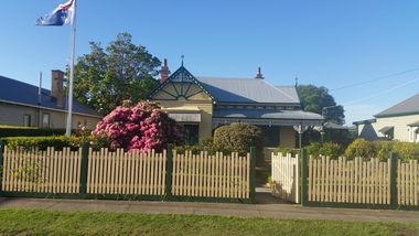 Hymettus Cottage & Garden Ballarat
Photograph, Hymettus October 2018, 2018
Photograph taken by Michael Taffe of Hymettus, family property at Ballarat since 1899 on the centenary of it being awarded "Champion Cottage Garden" for the City of Ballarat in 1918. -
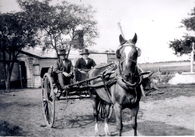 City of Kingston
Photograph - Black and white, c. 1920
Vic Peterson and his mother, Ida Peterson, are seated in a carriage with a horse harnessed to the front. Their property was between East Boundary and Brady Road, East Bentleigh.Black and white image of a horse and cart, with a man and woman sitting in the cart.Black ink printed on white round sticker on reverse: 335 Handwritten in red ink on reverse: 70%horse drawn wagon, east bentleigh -
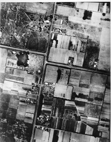 City of Kingston
Photograph - Black and white, c. 1944
Aerial photograph of Moorabbin, including Chesterville Road, Keys Road and Wickham Road, Moorabbin, Briggs cottage, Neill's waterhole, McKittrick property, site of FRUMELBlack and white aerial view of Moorabbin. Houses, market garens, roads, and water features are all clearly visible.Handwritten in red ink on reverseL A 603 / 97% [in red circle] Handwritten in blue ink on reverse: 9502 06111 / M'bbinmoorabbin, city of moorabbin, chesterville, keys, wickham -
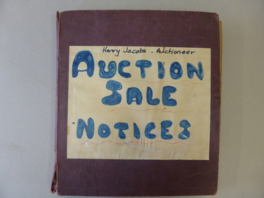 Warrnambool and District Historical Society Inc.
Book, Henry Jacobs Auctioneer: Auction Sale Notices, c1941
This scrapbook contains hundreds of auction sale notices for Warrnambool properties (and some more distant) dating from September 1941 to March 1972. In some instances the newspaper article noting the details of the sale and articles recording the result of the sale are included. The names of many of the real estate firms of the period form part of the advertisement. It provides a significant research tool relating to properties in Warrnambool and information to interpret the type of buildings available during this period. The firm of Henry J. Jacobs & Son, Auctioneers & Real Estate Agents was located at 146a Liebig Street with the known dates 1937 to 1964, and at 81 Liebig Street from the 1960s. Henry Jacobs' Frank Jacobs, also worked in the business. This book has been indexed in Houses and Properties Index.This scrapbook is of considerable local significance as it gives a great deal of information on people, properties, prices and sales in the timeframe (19401-1972). It is invaluable to researchers as it contains not only the details of the auctions at the time but also extra information on the owners and buyers and sellers, the names of the properties, the frequency of sales of properties of the time and the names of estate agents operating during the period. It has social significance in that it shows one manner in which business collated information.Dark red cloth bound scrapbook with brown paper pages. The front has a zig-zag imprint as a border and a paper label noting the title of the volume in blue and black text with red underlining. Inside the book has newspaper notices for auction sales from various Warrnambool real estate agents. The last pages are empty.Henry Jacobs - Auctioneer/ AUCTION/SALE/NOTICEShenry jacobs auctioneer, auctioneers, real estate agents, warrnambool, auction sales, jacobs, frank -
 Glen Eira Historical Society
Plan - Clarinda Street, 27, Caulfield South
A one page typed letter from Plante and Henty Solicitors on behalf of the Executor of the will of the late Grace Ellen Gillespie, to W V Scott of S P Simmonds and Co, dated 04/03/1957, requesting valuation of 27 Clarinda Street, Caulfield South for Probate purposes. The letter is accompanied by the Certificate of Title for the property which includes a map (87mm x 67mm) of the property. It is also accompanied by a floor plan (300mm x 205mm) of the house. The file also includes a two page copy of correspondence from W V Scott to Plante and Henty, dated 22/03/1957, providing the valuation of 27 Clarinda Street. The file also includes three pages of handwritten working notes for the purposes of the valuation which provide dimensions and estimated value of the property.scott w v, gillespie grace ellen, clarinda street, solicitors, s p simmonds and co estate agents, property values, land values, plans, architectural features, land titles, certificates, caulfield south, prahran east, elsternwick county of bourke, sycamore road, south caulfield, glenhuntly road -
 Whitehorse Historical Society Inc.
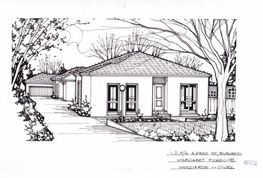
Artwork, other - Ink Line Drawing, 1,2,3/16 Alfred St., Burwood, 1995
A property illustration by Margret Picken Commissioned by the real estate agency Woodards, Camberwell for the purpose of advertising 1,2,3/16 Alfred St., Burwood for sale in 1995. Made by using Rotring ‘Rapidigraph’ drafting pens with Rotring ink on Rapidigraph polyester drafting film, double matte. The suburb lines are believed to have been redrawn, making this property no longer in Burwood, but located in Glen iris. 1/16 Alfred St., Burwood is listed as having sold for in 1995 for $185,000 Trained as a cartographic draftsman within the mining industry, Margaret Picken is an artist who worked producing property illustrations for real estate agencies in eastern suburbs of Victoria from 1983-2005. Retiring from the industry as technological changes favoured coloured photography over illustrations, and commissioning companies over sole contractors.This artwork is of Historical Significance as a record of local domestic architecture.A black ink line drawing on drafters film by Maragret Picken, of 1,2,3/16 Alfred St., Burwood. Depicted are three one-story rendered houses on one block, one behind the other, situated back from a front lawn with a large tree on the right, and a driveway on the left leading to a garage There to two hole punches just below the upper edge An approximately 1.5cmx0.5 tape reside mark at the centre of the bottom edge A 1cm vertical line of dirty tape residue on the center of the upper edge. 1,2,3/16 Alfred St., Burwood Margaret Picken - 95 Woodards - c'wellwhitehorse historical society, schwerkolt cottage, housing, architecture, margaret picken, burwood, glen iris, house, garden -
 Whitehorse Historical Society Inc.
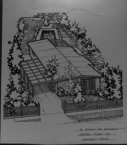
Artwork, other - Ink Line Drawing, 26 Highview Gve., Burwood E, 1994
A property illustration by Margret Picken Commissioned by the real estate agency Fletchers Real Estate for the purpose of advertising 26 Highview Gve., Burwood in 1994 Made by using Rotring ‘Rapidigraph’ drafting pens with Rotring ink on Rapidigraph polyester drafting film, double matte. This property is listed as having sold for $160,250 in 1994 Since being sold the land has been redeveloped, with nothing remaining of the house depicted in this drawing. Trained as a cartographic draftsman within the mining industry, Margaret Picken is an artist who worked producing property illustrations for real estate agencies in eastern suburbs of Victoria from 1983-2005. Retiring from the industry as technological changes favored coloured photography over illustrations, and commissioning companies over sole contractors.This artwork is of Historical Significance as a record of local domestic architecture.A black ink line drawing on drafters film by Margaret Picken, of 26 Highview Gve., Burwood East. An angled birds eye view from the street of a weatherboard house and carport. Extending to the backyards with pool, pagoda, and shed in the background. There are two hole punch holes on near the left edge. There are some crinkles in the paper near the top centre of the work. There is a two centimetre long mark along the centre top edge.26 Highview Gve., Burwood E Margaret Picken -94 Woodards B/Burnwhitehorse historical society, schwerkolt cottage, housing, architecture, margaret picken, burwood, house, garden -
 Whitehorse Historical Society Inc.
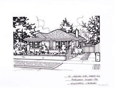
Artwork, other - Ink Line Drawing, Margaret Picken, 14 Jaques Grv., Forest Hill, 1993
A property illustration by Margret Picken Commissioned by the real estate agency Woodards Blackburn for the purpose of advertising 14 Jaques GVE., Forest Hill, This property is listed as having sold for $157,000 in 1993. The house depicted in this artwork is no longer standing. Having been demolished and a new house built in its place between the time of this artworks creation in 1993 and 2024. Made by using Rotring ‘Rapidigraph’ drafting pens with Rotring ink on Rapidigraph polyester drafting film, double matte. Trained as a cartographic draftsman within the mining industry, Margaret Picken is an artist who worked producing property illustrations for real estate agencies in eastern suburbs of Victoria from 1983-2005. Retiring from the industry as technological changes favored coloured photography over illustrations, and commissioning companies over sole contractors.This artwork is of Historical Significance as a record of local domestic architecture.A black ink line drawing on drafters film by Margaret Picken, of 14 Jaques Grv., Forest Hill, depicting a single story brick house set back from a low fence and front yard, with a driveway on the right. There are two hole punch holes centre near the upper edge.14 Jaques Grv., Forest Hill Margaret Picken- 93 Woodards - B/Burnwhitehorse historical society, schwerkolt cottage, housing, architecture, margaret picken, house, garden, forest hill -
 Surrey Hills Historical Society Collection
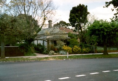
Photograph, 62 Windsor Crescent, Surrey Hills, 1988, 1988
Ref: Alan Holt records - This property was part of Lot 25 in the Windsor Park Estate which was subdivided in 1883. A house of 12 squares was built in 1888 at 64 Windsor Crescent for John Abernethy, an engineer. The property at 62 Windsor Crescent was built as a cottage and coachhouse associated with the main house at 64 Windsor Crescent. 1888-1891: Owners = John & Sarah Abernethy. John Abernethy died while on a trip to Hong Kong in 1891. 1891-1895: Owner = James Gibbon 1896-1897: Owner = John Steele See Alan Holt records for other short term owners. The properties at 62 and 64 Windsor Crescent were separated during WW1(by H Jenkinson). 1914-1923: Owner = Miss Dulcie Burchett, music teacher 1930-1953: Owner = William Langley & family.A colour photo taken from the street of a simple timber cottage with a brick chimney and green corrugated iron on the roof and verandah. The house has no front fence and is partly obscured by garden shrubs.victorian style, windsor park estate, cottages, timber houses, mr john abernethy, mrs sarah abernethy, mr james gibbon, mr john steele, miss dulcie burchett, mr william langley, surrey hills -
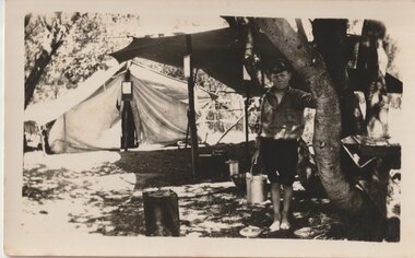 Melbourne Legacy
Photograph, Somers Camp, c1930
A black and white photo of a boy by a tent at a beach camp. It is labelled Somers Camp so this was a very early camp using tents, before camp buildings were erected. In the early years, Legacy organised outings to the property of Legacy founder, Legatee Stan Savige, who had a place in Balnarring close to the beach. Permanent camp buildings were built in 1930. In 1930 Lord Somers (Governor of Victoria) also started a camp at a nearby property and the area was renamed Somers. Legacy Somers Camps continued intermittently at Stan's property until it was decided in 1951 to make other arrangements for holidays. This photo was with a group of photos from around the 1930s from the early days of Legacy, including cricket team, football team, and camps at Balnarring/Somers (saved as 01915 to 01934).Legatee Savige's property at Balnarring became very important for Legacy providing outings and camps for junior legatees.Black and white photo of a boy with a bucket at a camp.Handwritten 'Somers Camp' in blue pen. Stamped '39' on back in grey ink.beach, tents, savige property, legacy somers camp -
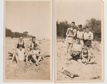 Melbourne Legacy
Photograph, Somers Camp, c1930
A black and white photo of six boys on a beach. The labels identify Jack Suggett and Norm Smith. Likely to be a very early camp for junior legatees at Somers. In the early years, Legacy organised outings to the property of Legacy founder, Legatee Stan Savige, who had a place in Balnarring close to the beach. Permanent camp buildings were built in 1930. In 1930 Lord Somers (Governor of Victoria) also started a camp at a nearby property and the area was renamed Somers. Legacy Somers Camps continued intermittently at Stan's property until it was decided in 1951 to make other arrangements for holidays. Legatee Savige was the key founder of Legacy in 1923. This photo was with other photos from the early days of Legacy, including cricket team, football team, and camps at Balnarring/Somers.Legatee Savige's property at Balnarring became very important for Legacy providing outings and camps for junior legatees.Black and white photo x 2 of boys in swimwear on a beach.Handwritten on group of 6 boys says 'L R. + Jack Suggett + + + Norm Smith' in blue pen. Both have stamped '4 28' on back in grey ink, implying they were printed at the same time. Stamped 'Printed by Harringtons' in purple ink.beach, junior legatee outing, swimwear, norm smith, legacy somers camp -
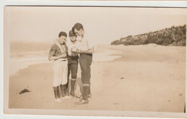 Melbourne Legacy
Photograph, Legacy Somers Camp, c1930
A black and white photo of junior legatees at Somers camp, probably in the 1930s. Names on the reverse say Les Mitchell and Roy Gilbert. In the early years, Legacy organised outings to the property of Legacy founder, Legatee Stan Savige, who had a place in Balnarring close to the beach. Permanent camp buildings were built in 1930. In 1930 Lord Somers (Governor of Victoria) also started a camp at a nearby property and the area was renamed Somers. Legacy Somers Camps continued intermittently at Stan's property until it was decided in 1951 to make other arrangements for holidays. These photos were with a group of photos from around the 1930s from the early days of Legacy, including cricket team, football team, and camps at Balnarring/Somers (saved as 01915 to 01934).Legatee Savige's property at Balnarring became very important for Legacy providing outings and camps for junior legatees.Black and white photo of Somers beach.Handwritten 'Left to right Les Mitchell, Roy Gilbert' in blue pen. Stamped '6 54' in black ink - same as 01928.beach, junior legatee outing, legacy somers camp, savige property -
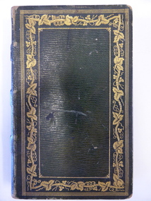 Warrnambool and District Historical Society Inc.
Book, Thalaba the destroyer Vol 1, 1821
This book was written in 1801 in an epic poem form. It is unrhymed. It falls into the category of fantasy. The original owner of this book seems to have been John Bland. He is most important in the early history of Port Fairy and had a business in Port Fairy with John Cowtan (corn millers and general merchants). The Cowtans originally had land in the vicinity of the Cassady property of Boughton, Merri River (in Caramut Road near Cassady’s Bridge today) and were related by marriage to the Cassadys. A later owner of the book was William Anderson whose father came to the Yangery district in 1854 and established the property of Rosemount and William remained in this area until his death in 1909. The Andersons were related by marriage to the Cassadys and this book came to us following a clearance sale at the Cassady property, Boughton. This book is of great interest less for its literary content than for its ownership which probably dates back to the 1840s. It is associated with the families of Bland, Cowtan, Cassady and Anderson, all early settlers in Warrnambool and district.This is a brown leather-covered book of 271 pages. The cover has gold decorative borders and patterns and gold lettering. The pages are gilt-edged. The book is the fourth edition of volume one of a Robert Southey poem and has a Preface and Books 1 to 5 with Notes. The inscriptions are handwritten in black ink. One signature has not been deciphered. ‘Wm. Anderson’ ‘John Bland’ william anderson,, rosemount, william cassady, john bland, john cowtan, thalaba the destroyer, warrnambool, poem thalaba the destroyer, 19th century poems, robert southey books -
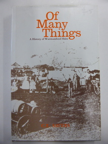 Warrnambool and District Historical Society Inc.
Book, Of Many Things, 1987
This book is the official history of the Shire of Warrnambool from 1863 to 1987. It was written by C.E. Sayers for the Shire of Warrnambool. Sayers also wrote the history of Warrnambool called By These We Flourish for the Warrnambool City Council. The Shire of Warrnambool was established in 1863 and the first meeting was held in January 1864. In 1992 the Shire covered an area of 1605 square kilometres and had a population of 8,940 and included the areas around Koroit, Allansford, Peterborough, Port Fairy and Nirranda. The Shire of Warrnambool was abolished in 1994 and was incorporated with other municipalities into the Shire of Moyne. This book is the official history of the Shire of Warrnambool and this copy is kept for future reference when the book is superseded or out of print. This is a hard cover book of 196 pages. It has a brown cover with gold lettering on the spine. The dust cover has a white background with an image on the front cover in brown and grey tonings of a rural property in the Shire of Warrnambool. The lettering on the dust cover is orange on the front cover and black on the spine. The book has a foreword, an introduction, 14 chapters of text, appendices and an index. There are many black and white photographs.shire of warrnambool, history of warrnambool, of many things -
Glenelg Shire Council Cultural Collection
Document - Antique Auction - 'Stanton Drew' Property Portland 1976, Stanton Drew, Portland, Victoria, Mar-76
23 page catalogue, produced by Leonard Joel Auctioneers and Valuers for the auction of antique furniture, Victoriana, china, silver, bric-a-brac etc. on the property 'Stanton Drew', 89 Wellington Road, Portland, Victoria, on Monday 15th March 1976. Glossy paper cover, burgundy and white photo of 'Stanton Drew' across front and back. Inside shiny white paper, burgundy print.stanton drew -
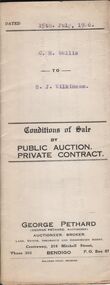 Bendigo Historical Society Inc.
Document - H.A. & S.R. WILKINSON COLLECTION: CONDITION OF SALE
Conditions of sale by private sale dated 15th. July, 1926 between C. H. Wallis and G. J. Wilkinson for property at 169 Arnold Street, Bendigo. Volume 5038, folio 1007513 together with dwelling and all sundry for the price of 725 pounds. With the contract there is a receipt from Tatchell, Dunlop, Smalley & Balmer Solicitors acknowledging payment of 725 pounds from G. J. Wilkinson.organization, business, h.a. & s.r wilkinson real estate -
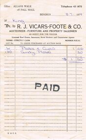 Bendigo Historical Society Inc.
Document - INVOICE, 1978
Invoice: Cream in colour. Office: Allan's Walk off Pall Mall. Telephone 43 1675. Bendigo 8.7.1978. M King. Dr to R.J.VICARS-FOOTE & CO. Auctioneer- Furniture and Property Salesmen. As agent for the Vendor. Licensed Real Estate, Insurance, Hotel Brokers and Commission Agents. Terms - Strictly CASH Member R.E.S.I. Invoice for crockery with PAID stamped in black ink. Box 625business, auctioneers, r.j. vicars-foote & co, allan's walk. r. j. vicars-foote & co. -
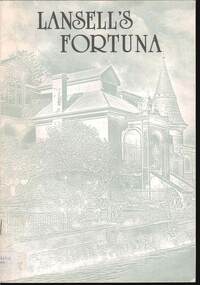 Bendigo Historical Society Inc.
Document - FORTUNA COLLECTION: LANSELL'S FORTUNA
Lansell's Fortuna Brochure -Stapled brochure -sketch of main entrance to Lansell's Fortuna Villa on the front cover /rear page shows 'Conceptual elevation for the development of Fortuna Villa by architect W.O. Beebe / the first page shows "Commanding Officer's Introduction 'with mention of George Lansell's most likely approval of the Army's acquisition of his property /the brochure contains black and white and coloured photosdocument -
 Bendigo Historical Society Inc.
Document - CORRESPONDENCE: VIEW ST PROPERTY OWNED BY CHARLES TATCHELL, 24th March, 1973
1973 correspondence to BHS re the two View St properties (257 and 267 View St) bought in 1923 by Charles Tatchell. Sold by family in 1939 Description in the letter from Tatchell's daughter about the history of the houses - the pair were called for many years ''Bellyache Terrace''. Known originally as Mount Pleasant House and View Hill House (later removed by Mrs Tatchell).Nancy Macpherson Smithperson, individual, charles tatchell, george lansell, view street, view hill house, mount plesant house, bellyache terrace, charles tatchell, london bank bendigo -
 Bendigo Historical Society Inc.
Photograph - EDITH LUNN COLLECTION: VIEWS ACROSS THE REAR OF PROPERTIES ON VIEW STREET, 28/0//1997
Two views across the rear of properties on View Street, towards Bendigo Bank Building Taken 28/08/1997 8A looking towards the Bendigo Bank building from the verandah of the Sandhurst Club 8B rear of National Bank on View Street and into the entrance of the Sandhurst Club 8C looking across Rosiland Park to Pall Mall from the verandah of the Sandhurst Club, View StreetEdith Lunn -
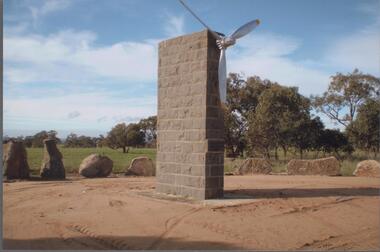 Bendigo Historical Society Inc.
Photograph - BENDIGO HISTORICAL SOCIETY COLLECTION: DUIGAN BROTHERS MEMORIAL MIA MIA
Colour photograph of the bluestone memorial erected to celebrate the first flight of an aeroplane by the Duigan brothers, Mia Mia/Baynton area The memorial has an aeroplane propeller attached at the top. . The first flight on an Australian made aeroplane was made by John Robertson Duigan on 16th July 1910, on the family property 'Spring Plains' Mia Mia. Photo taken during a BHS tour, possibly 1990's.aviation, civilian, duigan brothers -
Port Melbourne Historical & Preservation Society
Plan - Subdivision of area bounded by Nott Street, Rouse Street, Beach Street, Port Melbourne, Block Number 2067, 1884
Copy of plan of area bordered by Nott Street, Rouse Street, Beach Street, showing subdivision of land with relevant property owners (HB DONALDSON, J NOLAN, J Hill and Sons, GW ROBINS, Carl ECKBURG, JM SMITHSON, J WALLACE) Block number 1, Port Melbourne 1884, Block number 20.67. Water Mark on Paper "J Whatman 1883"built environment - domestic, j whatman, henry beveridge donaldson, j nolan, j hill and sons, g w robins, carl eckburg, j m smithson, j wallace -
 Port Melbourne Historical & Preservation Society
Photograph - Properties in Princes Street, Port Melbourne, 2013
Photographic images of properties in Port Melbourne. Image may have been taken by a PMHPS member or scanned from a past resident or taken for real estate sale purposes. Princes St - numbers 98; 220; 249; 293-299 (Friendly Society Dispensary - taken 10/11/2004); 351; 389. Also July 1990 images of HCV flats being demolished.built environment - domestic, princes street, friendly society dispensary -
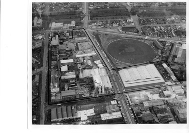 Port Melbourne Historical & Preservation Society
Photograph - Aerial view of J Kitchen & Sons site, Port Melbourne
The source of the images is unknown. The date has been estimated in reference to catalogue items 2989 (approx 1945) and 2990 (approx 1970) - both aerial photos of the area.Two black and white aerial photos of J Kitchen & Sons factory prrecinct, approximately 1960s. .01- Looking towards the East with Ingles St in the centre and Port Melbourne cricket/football ground on the right. Rail line is at the top. The Kitchen property is outlined. .02 - Looking towards the North with Port Melbourne cricket/football ground at the bottom, Kitchens (outlined) in the centre and other industrial to the North.built environment - industrial, industry - manufacturing, sport - australian rules football, business and traders - soaps/candles, j kitchen & sons pty ltd, port melbourne football and cricket ground, north port oval -
 Port Melbourne Historical & Preservation Society
Photograph - 124 Ross Street, Port Melbourne, Jack Bolt, 23 Dec 2012
Ten photos of 124 Ross St, formerly the home of "Mary the Cat Lady" (Mary Jones) The property is boarded up and fenced off prior to sale and demoltion. Mary was the subject of a one page entry (page 39) in "Women of Port Melbourne : Guide to the Exhibition" which included a photo of the houses and a sketch of Mary. Pictures of the site post demolition are Catalogue number 3467.01-.03built environment - domestic, domestic life, mary the cat lady, mary jones, jack bolt, women of port melbourne -
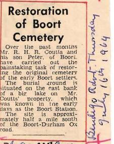 Bendigo Historical Society Inc.
Newspaper - HARRY BIGGS COLLECTION: RESTORATION OF BOORT CEMETERY
Newspaper article on cream coloured paper with red biro outlining the article with a cross at the four corners. Hand written at the side in blue biro is "Bendigo Advertiser July 16th 1964. The Article is about the Restoration of Boort Cemetery by Mr. R. H. R. Coutts and Peter Coutts of Boort. The burial ground is situated on Mr Coutts property which was known in the early days as Boort Station.Bendigo Advertisermemorials, graveboards, boort cemetry, boort cemetery, mr r. h. coutts, boort station. -
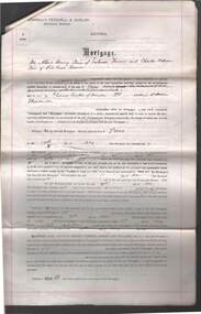 Bendigo Historical Society Inc.
Document - CONNELLY, TATCHELL, DUNLOP COLLECTION: A.H. & C.M. SIMS TO T. LUXTON
Mortgage document between Albert Henry & Charles William Sims of Pine Grove to T. Luxton Esq. dated 4th. January 1907, for land at Kerang. Two handwritten letters pinned to document. Also enclosed letter from Sims to Messrs Connolly Tatchell Dunlop re Barr Creek property, Gannawarra and Kerang . Letter from W.F. Boldt to Mr. J. Smalley.business, legal, connelly, tatchell and dunlop, a.h. & c.w. sims, luxton, pine grove, w.f.boldt, j. smalley, barr creek, gannawarra, kerang -
 Kew Historical Society Inc
Plan - Subdivision Plan, Kewdene Estate, 1937-1939
Pru Sanderson, in her groundbreaking ‘City of Kew Urban Conservation Study : Volume 2 - Development History’ (1988), summarised the periods of urban development and subdivisions of land in Kew. The periods that she identified included 1845-1880, 1880-1893, 1893-1921, 1921-1933, 1933-1943, and Post-War Development. These periods were selected as they represented periods of rapid growth or decline in urban development. An obvious starting point for Sanderson’s groupings involved population growth and the associated economic cycles. These cycles also highlighted urban expansion onto land that was predominantly rural, although in other cases it represented the decline and breakup of large estates. A number of the plans in the Kew Historical Society’s collection can also be found in other collections, such as those of the State Library of Victoria and the Boroondara Library Service. A number are however unique to the collection.The Kew Historical Society collection includes almost 100 subdivision plans pertaining to suburbs of the City of Melbourne. Most of these are of Kew, Kew East or Studley Park, although a smaller number are plans of Camberwell, Deepdene, Balwyn and Hawthorn. It is believed that the majority of the plans were gifted to the Society by persons connected with the real estate firm - J. R. Mathers & McMillan, 136 Cotham Road, Kew. The Plans in the collection are rarely in pristine form, being working plans on which the agent would write notes and record lots sold and the prices of these. The subdivision plans are historically significant examples of the growth of urban Melbourne from the beginning of the 20th Century up until the 1980s. A number of the plans are double-sided and often include a photograph on the reverse. The advertisement for the ‘Kewdene Estate’ subdivision is pasted over a photograph of a property for sale. This is typical of the reuse of promotional materials in the period during, and subsequent to World War I. The subdivision included 14 lots bordered by Belmore Road, Birtles Street and Giles Street. On the other side of the subdivision [Glass] Creek is noted. The subdivision plan also shows part of the Outer Circle Railway and Deepdene Railway Station.subdivision plans - east kew, kewdene estate, belmore road -- kew east (vic.), giles street -- kew east (vic.) -
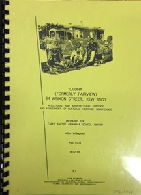 Kew Historical Society Inc
Document, Allan Willingham, Cluny (Formerly Fairview) 34 Wrixon Street, Kew 3101: A cultural and architectural history and assessment of cultural heritage significance / Allan Willingham, 2006
Research Report on Fairview, Cluny, held in the KHS Reference Files. Research report, prepared by Allan Willingham for Carey Baptist Grammar School in 2006, into Cluny (formerly Fairview) 34 Wrixon Street, Kew 3101. The cultural and architectural history and assessment of cultural heritage includes a summary of the building's current heritage status, a history of the property, biographical portraits of the principal owners, an architectural history, an assessment of its cultural heritage significance, a statement of conservation policy and appendices.fairview -- wrixon avenue -- kew (vic.) -
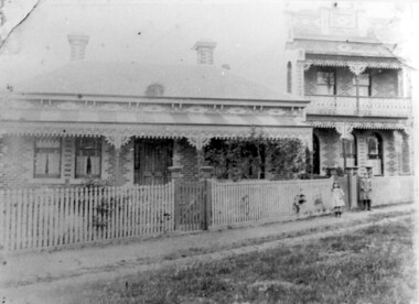 Surrey Hills Historical Society Collection
Photograph, 'Maitland', 1 Bedford Avenue, Surrey Hills, c 1900, 1900
Maitland' was built in 1889 for Thomas Zeplin, who was a Professor of Music. He owned all the land bound by Union Road, Wilson and Montrose Streets and the railway line. 1 Bedford Avenue stayed in family ownership until purchased by Camberwell Council in 1986, initially for a car park. However it was renovated to become part of Surrey Hills Neighbourhood Centre. It was opened on 23 November 1990. No 3 Bedford Avenue was built for Thomas Zeplin's daughter and named 'Mervyl' or 'Merryl'. Mrs Brodecky (donor) was the great-granddaughter of Thomas Zeplin. The 2 girls are granddaughters of Thomas Zeplin. Electoral roll information: 1972 & 1977: Albert Vojteck Brodecky, manager, 1 Bedford Avenue. 1977: Ray Nanette Brodecky. There are 2 copies. Thomas had this built for his son and family. The house was occupied by his family, though sometimes rented out. His great-grand-daughter Mrs. A. Brodecky sold to the Camberwell Council in 1986. This was the only surviving photo in the family after the fire. Courtesy: Mrs. A. BrodeckyBlack and white photo of 2 houses taken from the street front. On the LHS is a Victorian double-fronted single-storey villa of Hawthorn brick construction, with wrought iron lacework to the veranda, slate roof and picket fence, with an established garden. Next door at No 3 is a double-storey Victorian terrace with a similar fence and building materials. There are 2 young girls standing in front between the properties.maitland, bedford avenue, 1900, surrey hills neighbourhood centre, victorian style, mervyl, merryl, mr thomas zeplin, mrs nanette brodecky, mr albert vojteck brodecky