Showing 4736 items matching "1881-1959"
-
 Ringwood and District Historical Society
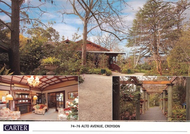
Document, Real Estate History of "Shadowood", 74-76 Alto Avenue, Croydon, Victoria
Folder of Estate Agent's notes compiled in preparation for property auction, 11th October, 2008. Two-page history of "Shadowood", display photo of house with floor plan dating from circa 1920s, copies of LANDATA title documents. Map of Wicklow Hills subdivision, including Alto Avenue, Elesmere Avenue, Glenora Avenue, Wicklow Avenue, and railway line to Lilydale. Title Vol 1323 Fol 264412 Allotment 43C Parish of Warrandyte - Ann McKean, dated 6th October, 1881. Title Vol 1937 Fol 387367 Part of Allotment 43C Parish of Warrandyte - Richard Bonynge Kelly, 11th August, 1887. Title Vol 2728 Fol 543569 Part of Allotment 43C Parish of Warrandyte - Thomas Robertson, 27th July, 1898. Title Vol 4161 Fol 832181 Part of Allotment 43C Parish of Warrandyte - John Gordon Robertson, 4th November, 1918. Title Vol 4490 Fol 897808 Lots 82 and 83, Plan of Subdivision 7478 - Elizabeth Rutherford Morell, 12th August, 1921. Title Vol 4617 Fol 923322 Lot 82, Plan of Subdivision 7478 - Flora Clapperton, 23rd September, 1922. Title Vol 8409 Fol 533, part of Lot 82, Plan of Subdivision 7478 - Hugh Ravenscroft Hastings Wettenhall and Sybella Anne Wettenhall, 1st May, 1962. -
 Bendigo Historical Society Inc.
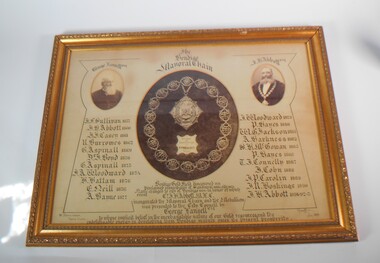
Memorabilia - FRAMED IMAGE OF BENDIGO MAYORAL CHAIN
Large framed item. At the centre a photograph of the Bendigo Mayoral Chain designed and manufactured by F. Prescott, jeweller, Bendigo At the right a photo of George Lansell esq. and on the left a photo of J.H. Abbott esq. A list of Mayor is underneath the two photos, starting from the left J.F. Sullivan 1857, J.H. Abbott 1860, J.J. Casey 1861, R. Burrows 1862, G. Aspinall 1869, J. Boyd 1870, G. Aspinall 1873, J.A. Woodward 1874, H.Hattam 1876, E. Neil 1876, A. Bayne 1877, J.A. Woodward 1879, P. Hayes 1880, W.G. Jackson 1881, A. Harkness 1882, S.H. McGowan 1885, P. Hayes 1886, T.J. Connelly 1887, J. Cohn 1888, J.P. Carolin 1889, J,R. Hoskins 1890, J.H. Abbott 1891-92-95. Under the Mayoral chain the words: Bendigo gold fields discovered 1851. Proclaimed municipality of Sandhurst 1855 and city in 1871. Name changed to City of Bendigo in honor of which event cnr. J.H Abbott inaugurated the mayoral chain and the medallion was presented to the City Council by George Lansell esq. To whose implicit belief in the inextinguishable nature of our gold resource and the indefatigable energy in developing them Bendigo manly owes its present prosperity. July 1893, W. Honeybone Town Clerk and signed by F. Prescott.bendigo, council, mayoral chain, from dudley house stored at bendigo art gallery from 2000, returned to bhs 03/02/2023 -
 Victorian Interpretive Projects Inc.
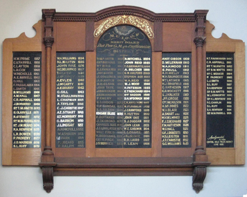
Honour Board (photograph), Clare Gervasoni, MUIOOF Honour Board, 2013
The original Honour Board for the Castlemaine branch of the Manchester Unity Independent Order of Oddfellows was hanging in the Castlemaine Market Building in 2013.Colour photograph of a timber honour board for the Provincial Grand Masters of the Castlemaine Branch of the Manchester Unity Independent order of Oddfellows. The Provincial Grand Masters are: 1859 Wal Smith 1861 George Farroll 1862 William Bird 1863 G.J. Fawkner 1864 Joseph Davie 1865 J. Collings 1866 J.D. Hatch 1867 S.H. Clark 1868 John Tate 1869 J. Mackenzie 1870 J.H. Dickinson 1871 F. Emery 1872 H. London 1873 C.F. Randal 1874 H.S. Hilton 1875 Edgar Slee 1876 Francis Rotanzi 1877 J. Desmond 1878 Charles Slee 1879 J.S. Unklater 1880 William Field 1881 W. Broughall 1882 George H. Page 1883 J.S. Horner 1884 R. Mitchell 1885 John Reid 1886 C.C Servante 1888 A. Belcher 1889 G.W. Halford 1890 Stephen Box 1891 W.A. Reid 1892 W.J. Wood 1893 H. Paterson 1894 E. Trenchard 1895 Robert Maddin 1896 D.H. McDonach 1897 C.W. Armstrong 1898 M. O'Loughlan 1899 J. Crawford 1900 R. Hutton 1901 John Oke 1902 D.J. Duggan 1903 john Lean 1904 W.E. Goodwin 1905 S.S. graves 1906 J.H. Liscombe 1907 R.H. Laird 1908 R. Leanmanchester unity independent order of oddfellows, muioof, castlemaine, -
 RMIT GSBL Justice Smith Collection
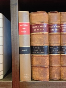
Journal series, Butterworth & Co, Victorian reports, 1878
Previous owners: T. H. Smith, T. W. SmithNo. of volumes: 185 Volume range: 1878-2008 Missing volumes: 1881-1883 & 1891 Previous titles include: Victorian law reports Victorian law times Wyatt & Webb's law reports Wyatt, Webb & A'Beckett's law reports A'Beckett's reserved Williams practice Also includes: 1861-1996 Consolidated index : A-H 1861-1996 Consolidated index : I-Z 1861-1996 Consolidated tables Consolidated index and tables of cases 1966-1973 together with Victorian Statutes annotations 1968-1973 : cumulative supplement Cumulative supplement index and tables : 1997 - 2000 & 1997 - Vol. 5 & 1997 - Vol. 10 Editors: Webb, G. H. F. (1878-1886) Davis, P. S. (1886-1887) Burnett Box, J. (1888-1905) Moule, W. H. (1905-1906) Duffy, F. G. (1907-1913) Davis, A. H. (1913-1928) Richardson, J. A. (1929-1936) Joske, P. E. (1936-1956) Anderson, K. (1956-1969) Fogarty, J. F. (1969-1975) Archibald, A. C. (1976-1982) Karkar, J. H. (1982-1994) Pearce, M. R. (1995-2002) Tracey, R. R. S. (2002-2005) MacLean, D. M. (2005-2007) Maker, L. W. (2006-2008)ISSN: 00425214law reports; digests; etc -- victoria -
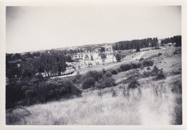 The Beechworth Burke Museum
Photograph, 1960s
This photo was taken in the 1960s from a northeast position looking down towards Lake Sambell, the caravan park, and the surrounding area. This photo was taken during a period of rejuvenation for the lake area including the opening of the caravan park in 1959 and the swimming pool area in 1961 (this pool is just visible in the centre of the photo). The popularity of caravanning in Australia exploded during this post-war period of the late 1950s and 1960’s. This popularity was driven by multiple factors, including: the stopping of fuel rations, the accessibility of car ownership through the manufacturing of affordable cars, technological developments in caravan design, and the increase in prosperity and leisure time for many Australians. Lake Sambell is an artificial lake that was developed on the previous site of the Rocky Mountain Mining Company workings and was officially opened by Minister for Lands, Mr Baily, on October 5, 1928. The disused and unattractive remains of the mine were converted into a recreational area intended for swimming, boating, and fishing. The lake is named after Mr L.H. Sambell, shire engineer and secretary of the Forward Beechworth Committee, who advocated for the enhancement of Beechworth into a tourist destination and was central to the planning and establishment of the lake. Funding for the project was raised by both competition funds and donations. Since the construction in 1928 several engineering issues have arisen. In 1939 the water levels were low, and the lake was considered both an eyesore and ‘mudhole’, Beechworth Shire Council sort funding to raise the height of the lake six feet to improve the quality of water. Throughout the 1940s the Beechworth Swimming Club tried to raise awareness and funds to address the structural engineering issues and improve swimming facilities at the lake. R.E. Carter, similar to L.H. Sambell, was a shire engineer who advocated the importance of positioning Beechworth as a tourist destination. Carter held the position from 1954-63 and organised many improvements to the Lake Sambell area including the caravan park in 1959, the lake swimming pool in 1961, water skiing and boating facilities, and increased the lake surface are in 1964. These improvements were financed mainly by grants from the Tourist Development Authority. This photograph is of historical significance as it documents Lake Sambell and the surrounding area in the 1960s after a phase of enhancements to improve the appearance and usability for both the people of Beechworth and tourists. It is also of social significance in providing an insight into the increase in leisure time and access to travel during a period of post-war prosperity.Black and white rectangle photograph printed on matte photographic paper and unmounted.Reverse: 1 / [logo KODAK/ VELOX/ PAPER] / C798 / 3535lake sambell, lake sambell caravan park, lake sambell swimming pool, caravan park, caravanning 1960s, rocky mountain mining company, l.h. sambell, r.e. carter, beechworth swimming club, forward beechworth committee, minister of lands, tourist development authority, lake swimming, swimming, boating, fishing, water skiing, beechworth 1960s, lake sambell fishing, lake sambell boating -
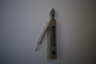 Warrnambool and District Historical Society Inc.
Thermometer, bath and holder, Early 20th century
This item belonged to Dr Horace Holmes. It is a floating thermometer used to determine when bath water was suitable for use. The reference to Dr Forbes is to John Forbes, a Scottish physician who recommended therapeutic bathing at a time when taking a bath at home or in a hospital was not a common practice (19th century). Dr Horace Iles Holmes (1877-1959) was born and educated in Tasmania and completed a medical degree at Melbourne University. He commenced a practice in Warrnambool in 1906 and was the Honorary Medical Officer at the Warrnambool Hospital and Warrnambool’s Health Officer. His practice was at ‘Ierne’, at the corner of Spence and Kepler Streets. He was an early member of the Royal Australian College of Surgeons and was prominent in community affairs (foundation president of Warrnambool Rotary Club, a member of the local Masonic Lodge for over 50 years, Warrnambool Hospital Committee member, long-term Trustee of the Warrnambool Methodist Church and President of the Lyndoch Hostel for the Aged Committee) Dr Holmes also had agricultural interests and enjoyed fishing, golf and bowls. This is an important medical item from the collection of Horace Iles Holmes, a doctor who was prominently associated with the professional and community life of Warrnambool for well over 50 years. This is a thermometer with a glass tube containing mercury with funnel endings. A piece of paper with gradations and printed matter is rolled up inside the tube. The thermometer is encased in an unpainted wooden container which has a handle and a hollow middle for taking the thermometer readings. ‘Dr Forbes Specifications’ ‘Hot, Warm, Tepid, Temp, Cool, Cold Bath, Freezing’ dr horace holmes, warrnambool, hospital equipment, thermometers, history of warrnambool -
 Tatura Irrigation & Wartime Camps Museum
Rose Bowl, 1956
This trophy was initiated at T.LC. in 1956, donated by Mr H.S. (Tib) Reilly to attract prominent district & Melbourne players to the annual tournament on Australia Day weekend. The conditions were that any player winning the event 3 times would hold the trophy permanently and Mr Reilly undertook to provide a replacement. Mrs Val Constable (nee Huxtable) won the trophy outright for the first time in 1962 and she has donated it to the museum to honour Mr Reilly's contribution to the Tatura community. Mr Reilly was a prominent businessman, J.P. and very active in promoting the development of Tatura. Winners from 1956-1962: 1956 Mrs N. Nethersole, 1957 Miss P. Radford, 1958 Miss V. Huxtable, 1959 Mrs D. Constable, 1960 Mrs N. Nethersole, 1961 Miss M. Burke, 1962 Mrs D. Constable. Tatura Lawn Tennis Club Mr H.S. Reilly T.L.T.C. Annual Tennis Tournament (Australia Day).Large silver rose bowl provided by Mr H.S. Reilly to promote the annual tennis tournament (Australia Day). First presented in 1956 and won in perpetuity in 1962. Winners' names inscribed for each year.Tatura Lawn Tennis Club. Ladies Open Singles Championship H.S. Reilly Rose Bowltatura, recreations, sports, tatura lawn tennis club, australia day tennis tournament, h s reilly, val constable nee hustable, mrs n nethersole, miss p radford, mrs d constable, miss m burke -
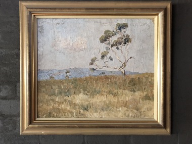 Robin Boyd Foundation
Painting, Arthur Boyd, Wheat Fields Behind Rosebud, 1938
In 1938, Robin Boyd's grandfather Arthur Merric Boyd offered Robin his first commission, a studio for Robin's first cousin Arthur Boyd on the family property at Murrumbeena. This painting by Arthur Boyd was part of Ralph Madder’s estate and inherited by his daughter, Patricia, Robin Boyd's wife. Ralph Madder (1892 - 1986) was Arthur Boyd’s uncle and employed the young Arthur in his calcimine paint factory and bought the occasional painting to help the young artist. This painting dates from a later time when Arthur was living with, and looking after, his aged grandfather Arthur Merric at Rosebud (see the book “The Boyds” by Brenda Niall pages 188-9). “Wheat fields behind Rosebud” did not come to 290 Walsh Street until after Ralph Madder’s death in 1986. Note: Robin Boyd's uncle Merric Boyd (1888-1959) married Patricia’s aunt Doris Gough. This means that Arthur Boyd was a first cousin to both Robin Boyd and Patricia Madder. Landscape in gold wooden frameA.M.B Boyd 1938 on lower right hand sidearthur boyd, arthur merric boyd, robin boyd, walsh st artwork, ohm2022, ohm2022_1 -
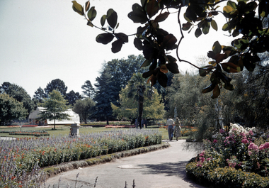 City of Ballarat Libraries
35mm Slide, Keel Glasshouse at the Botancal Gardens circa mid 1950s
A delightfully framed shot of the Botanical Gardens in the mid to late 1950s. We can be reasonably sure of the date of this image because it shows the Keel House conservatory. Designed and fabricated in England, it was then re-assembled in the Ballarat Gardens in 1906. It was purely for display, only allowing public viewing through glass windows at either end. It became known as the Keel House because the roofline resembled a boat hull. The Keel House was replaced in 1959 by Cuthbert House, another conservatory which also did not allow public access. Cuthbert House was replaced in 1995 by the present Robert Clark conservatory, which allows public access for the first time. Note other details in this photograph, the sprinkler at full bore and the little boy hiding behind the sundial. Mrs Bon Strange and her husband Bert were well known Ballarat residents. When Mrs Strange died some years ago, her extensive slide collection was sorted through and those relevant to Ballarat were gifted to the Ballarat Library.greenhouse, glasshouse, keel glasshouse, garden, building, public building, ballarat botanical garden -
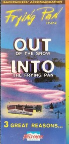 Falls Creek Historical Society
Flyer - Out of the Snow into the Frying Pan, 1995
With the completion of the Kiewa Hydroelectric Scheme in 1959, Falls Creek began to change from being a construction site into an alpine tourism resort. In 1964 the Frying Pan Inn group consisting of Bill Bridgford, Geoff Henke and L G Morrison acquired a license to construct a restaurant. It opened in time for the 1965 season, but the Frying Pan venue was damaged by fire in 1967. Renovations took until 1973 when the Frying Pan Inn reopened. It is now a popular Apres Ski location in the heart of Falls Creek Village. The Frying Pan has always been the central hub of The Bowl and at different times in the past has been the location of the Old Race Hut and also the Ski School Meeting Point. This flyer promotes three benefits of the Frying Pan Inn - its Backpackers' Accommodation, a great location and its nightlife which included live touring bands, comedy nights and Happy Hour. Accommodation included four or six person shared rooms, with breakfast being available at an additional cost.This item is significant because it documents activities and accommodation at a well-known venue at Falls Creek.A coloured flyer to promote the Frying Pan Inn featuring photographic images, basic information about facilities and accommodation tariffs for the winter of 1995.frying pan inn, falls creek accommodation -
 Melbourne Tram Museum
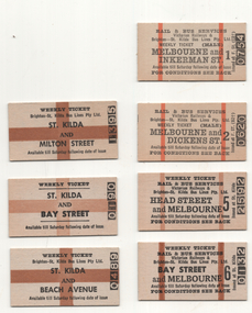
Ephemera - Weekly Tickets - rail and bus St Kilda Bus lines - set of 7, Victorian Railways (VR), 1960s
Following the complete closure of the St Kilda - Brighton Electric street railway (tramway) in 1959, the Brighton St Kilda Bus lines operated a service under a contract with the Victorian Railways with a joint ticketting arrangement. These tickets are weekly tickets for various locations along the former tramway. Those tickets available for Melbourne have the conditions of travel on the rear. The two vertical stripes indicated that the ticket was available to pass through the gates at Flinders St or Spencer St, while the large cross indicated to a ticket checker that the ticket was not available beyond St Kilda station or to pass through a set of gates. All printed on a off white card. All undated. 1 - Melbourne & Inkerman St - No. 0754 - Male 2 - Melbourne and Dickens St - No. 0620 - Male 3 - Head St and Melbourne - No. 25592 4 - Bay St and Melbourne - No. 0132 5 - St Kilda and Milton St - No. 1395 6 - St Kilda and Bawy St - No. 0190 7 - St Kilda and Beach Ave - No. 0489Demonstrates a railway ticketting system that was used on buses and railwaysSet of 7 Edmondson style railway tickets printed as Weekly tickets.railways, tickets, weekly tickets, st kilda brighton electric tramway, buses, brighton - st kilda bus lines -
 Department of Energy, Environment and Climate Action
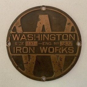
Washington Winch - identification Plate
The Washington Winch sits deep in the forest east of Swifts Creek and is the last one of its particular type left in Australia. It was made by the Washington Iron Works company in Seattle. This unique winch was one of two machines imported in 1920 to operate in the Karri forests of WA. Both machines were later purchased by the Forests Commission after the 1939 bushfires for salvage logging at Toorongo to drive elaborate "high lead" cable systems. This particular machine was later sold to Jack Ezard from Swifts Creek in 1959 where it operated on its current site until about 1961. The fate of the second machine is unknown. It was possibly cannibalised for parts. The Ezards were innovative sawmillers who introduced high lead logging into Victoria. They had owned and operated sawmills in the Warburton area from 1907, before shifting to Erica in Gippsland in 1932. Bulldozers and powerful logging trucks eventually made steam and the Washington Winch redundant. The winch is listed on the State Heritage Register. Only one of its kindBrass identification plate recovered from the Washington Winch near Swifts Creek 21 cm in diameter11 x 14 refers to the double drums The serial number is assumed to be 3832forest harvesting -
 Chelsea & District Historical Society Inc
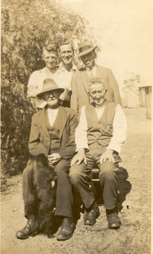
Photograph - The Brown Family, Frederick and Alexander
Seated - Frederick Brown (known as Fred) (1860-1959) and Alexander Brown (known as Alex) (1863 - 1940), are the sons of Hugh Brown, a pioneer of the district. Hugh Brown (1830-1930), born in Ireland, arrived in Adelaide in 1855 and in the Mordialloc district in 1856. Mr Brown brought land in 1866 and built his farmhouse “Pine Vale” in 1870 near the site of the present Mordialloc Secondary College (then part of the property) and extended his property when the swampland was made open for selection in 1871. The property was a market garden and orchard. Hugh Brown married Zillah Baxter (1866) and they had six sons, five living to adulthood. The Brown family increased their land holding until they held a major part of the farmland between Mordialloc Creek to almost the Aspendale Railway Station. The property was a market garden and orchard. Mr Brown took an active interest in the public life of the community, a Justice of the Peace; Councillor of Dandenong Shire for over 30 years, was twice Shire President; and a founding member of the Mordialloc Mechanics Institute. Sepia studio photo of five men, three younger men standing behind two sitting.hugh brown, mordialloc, pioneer, zillah brown, zillah baxter, pine vale, alex brown, alexander brown, fred brown, frederick brown -
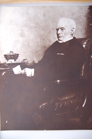 Camperdown & District Historical Society
Photograph - James Dawson, Thomas Rodger, c1881
James Dawson (1806-1900), pastoralist, friend to First Nations people, environmentalist, patron of the Arts and author of "Australian Aborigines" (1881). Dawson came from Bonnytoun, near Linlithgow, Scotland and arrived in Melbourne with his wife, Joan Alexander Park, on 2 May 1840. They made their first home in the colony farming in Port Phillip, near Anderson's Creek on the Yarra River, where their daughter, Isabella was born in 1842, then from 1844, moved to 'Kangatong' station on the Moyne River, east of Macarthur. In 1866 the Dawsons left the Port Fairy district and lived in various residences in Melbourne. By 1868 the family had settled in Camperdown at 'Wuurong', on the banks of Lake Bullen Merri. Unlike most people at the time, Dawson and his daughter shared a deep interest in, and respect for First Nations people. In 1876 James Dawson was appointed local Guardian of the Aborigines in the Camperdown district. He was a prolific letter writer and an early advocate for indigenous rights and was dedicated to exposing injustice and the maltreatment of First Nations people. He had befriended Wombeetch Puyuun (Camperdown George) who was the last of the local Djargurd Wurrung living on Country when he died in February 1883. In 1885 James Dawson erected the Wombeetch Puyuun Monument at Camperdown Cemetery in his memory. His friend's remains were reburied at the foot of the obelisk and the two dates, 1840-1883, mark the 43 years it took for European settlement to displace the Djargurd Wurrung from the Camperdown District.Sepia photograph of an elderly James Dawson taken in Scotland. Front: T. Rodger St. ANDREWS N.B. Back: THOMAS RODGER Photographer ST. ANDREWS ETABLISHED 1849cdhs, isabella dawson, camperdown cemetery, djargurdwurrung, cdhsfirstnations -
 Camperdown & District Historical Society
Book - The James Dawson Scrapbook, c1881
James Dawson (1806-1900), pastoralist, friend to First Nations people, environmentalist, patron of the Arts and author of "Australian Aborigines" (1881). Dawson came from Bonnytoun, near Linlithgow, Scotland and arrived in Melbourne with his wife, Joan Alexander Park, on 2 May 1840. They made their first home in the colony farming in Port Phillip, near Anderson's Creek on the Yarra River, where their daughter, Isabella was born in 1842, then from 1844, moved to 'Kangatong' station on the Moyne River, east of Macarthur. In 1866 the Dawsons left the Port Fairy district and lived in various residences in Melbourne. By 1868 the family had settled in Camperdown at 'Wuurong', on the banks of Lake Bullen Merri. Unlike most people at the time, Dawson and his daughter shared a deep interest in, and respect for First Nations people. In 1876 James Dawson was appointed local Guardian of the Aborigines in the Camperdown district. He was a prolific letter writer and an early advocate for indigenous rights and was dedicated to exposing injustice and the maltreatment of First Nations people. He had befriended Wombeetch Puyuun (Camperdown George) who was the last of the local Djargurd Wurrung living on Country when he died in February 1883. In 1885 James Dawson erected the Wombeetch Puyuun Monument at Camperdown Cemetery in his memory. His friend's remains were reburied at the foot of the obelisk and the two dates, 1840-1883, mark the 43 years it took for European settlement to displace the Djargurd Wurrung from the Camperdown District.The James Dawson Scrapbookcdhs, isabella dawson, camperdown cemetery, djargurdwurrung, cdhsfirstnations -
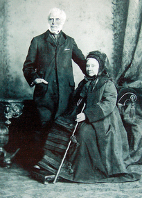 Camperdown & District Historical Society
Photograph - James and Joan Dawson, studio photograph, c1878
James Dawson (1806-1900), pastoralist, friend to First Nations people, environmentalist, patron of the Arts and author of "Australian Aborigines" (1881). He married Joan Alexander Park in 1877. Joan was the niece of the famous African explorer, Mungo Park. James Dawson came from Bonnytoun, near Linlithgow, Scotland and arrived in Melbourne with his wife on 2 May 1840. They made their first home in the colony farming in Port Phillip, near Anderson's Creek on the Yarra River, where their daughter, Isabella was born in 1842, then from 1844, moved to 'Kangatong' station on the Moyne River, east of Macarthur. In 1866 the Dawsons left the Port Fairy district and lived in various residences in Melbourne. By 1868 the family had settled in Camperdown at 'Wuurong', on the banks of Lake Bullen Merri. Unlike most people at the time, the Dawson's shared a deep interest in, and respect for First Nations people. In 1876 James Dawson was appointed local Guardian of the Aborigines in the Camperdown district. He was a prolific letter writer and an early advocate for indigenous rights and was dedicated to exposing injustice and the maltreatment of First Nations people. He had befriended Wombeetch Puyuun (Camperdown George) who was the last of the local Djargurd Wurrung living on Country when he died in February 1883. In 1885 James Dawson erected the Wombeetch Puyuun Monument at Camperdown Cemetery in his memory. His friend's remains were reburied at the foot of the obelisk and the two dates, 1840-1883, mark the 43 years it took for European settlement to displace the Djargurd Wurrung from the Camperdown District.Studio portrait of James and Joan Dawson taken in Australia. cdhs, isabella dawson, camperdown cemetery, djargurdwurrung, cdhsfirstnations -
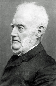 Camperdown & District Historical Society
Photograph - James Dawson, c1878
James Dawson (1806-1900), pastoralist, friend to First Nations people, environmentalist, patron of the Arts and author of "Australian Aborigines" (1881). Dawson came from Bonnytoun, near Linlithgow, Scotland and arrived in Melbourne with his wife, Joan Alexander Park, on 2 May 1840. They made their first home in the colony farming in Port Phillip, near Anderson's Creek on the Yarra River, where their daughter, Isabella was born in 1842, then from 1844, moved to 'Kangatong' station on the Moyne River, east of Macarthur. In 1866 the Dawsons left the Port Fairy district and lived in various residences in Melbourne. By 1868 the family had settled in Camperdown at 'Wuurong', on the banks of Lake Bullen Merri. Unlike most people at the time, Dawson and his daughter shared a deep interest in, and respect for First Nations people. In 1876 James Dawson was appointed local Guardian of the Aborigines in the Camperdown district. He was a prolific letter writer and an early advocate for indigenous rights and was dedicated to exposing injustice and the maltreatment of First Nations people. He had befriended Wombeetch Puyuun (Camperdown George) who was the last of the local Djargurd Wurrung living on Country when he died in February 1883. In 1885 James Dawson erected the Wombeetch Puyuun Monument at Camperdown Cemetery in his memory. His friend's remains were reburied at the foot of the obelisk and the two dates, 1840-1883, mark the 43 years it took for European settlement to displace the Djargurd Wurrung from the Camperdown District.Side portrait of an elderly James Dawson. cdhs, isabella dawson, camperdown cemetery, djargurdwurrung, cdhsfirstnations -
 Victoria Police Museum
Police Stations (Apollo Bay)
Apollo Bay is a coastal town in southwestern Victoria. It is situated on the eastern side of Cape Otway, along the edge of the Barham River and on the Great Ocean Road, in the Colac Otway Shire. The original township was surveyed in 1853 and named Middleton. In 1881 the town was renamed Krambruk which was changed to Apollo Bay in 1898. The Krambruk Police Station was opened on 7 March 1888 in the Southern District on land opposite the site of the current Mechanics' Institute and changed its name to the Apollo Bay Police Station on 1 September 1990. It came under the Barwon District in 1948 and "Lima" Western District from 4 March 1990. In 1930 the police station was located to 29 Nelson Street. It was a seven-roomed weather-board dwelling on three-quarters of an acre of land. It consisted of six rooms of pine, lined and painted; one pantry; one bathroom and wash-house; one hall; one office and one W.C.. There was stabling for one horse and one cell for prisoners. It was staffed by one Mounted Constable. In the early 1970s land was acquired at 31 Nelson Street and a new police station was constructed. This was a three-roomed brick building with a cell block at the rear. By the time it closed in 2005 it had been extended twice. On 17 November 2006 the current Apollo Bay Police Station opened in its current location at 35a Nelson Street, on the corner of Cartwight Street). Outside the peak summer season, the station is open 16 hours per day and staffed by one sergeant and five other members. 3 black & white photos and 2 coloured photospolice stations; apollo bay police station -
Glen Eira Historical Society
Article - VICTORIAN RAILWAYS
File contains 3 items: 1/Original handwritten notes by Leo J Harrington (VR Melbourne) and T O’Callaghan titled ‘Victorian Railways to ‘62’. Notes include dates of electrification of lines, station openings, valuations, railway station names and their origins. Reference to council minutes regarding request to change the name of Elsternwick station to Caulfield in June 1871. 2/Original newspaper article from ‘The Age’ dated 10/06/1978 by Graeme Davidson titled ‘A case study of Railway politics’. Article refers to a publication called ‘Return to Rosstown, Railway, Land Sales and Sugar Beet ventures in Caulfield’ by D. F. ‘Return to Rosstown’ recounts the story of the Rosstown Junction railway and its creator, William Murray Ross. Tells of Ross’ life since coming to Australia from Liverpool and how he prospered as a land speculator owning large tracts of land in Caulfield, the sugar mill and his plans to operate a railway. 3/Original newspaper article (and image) from ‘Moorabbin Standard’ dated 25/11/1981, titled ‘Centenary train to carry mayors’. Article reports that a special train will run from Spencer Street Station to Mordialloc railway Station on Saturday 19/12/1981 to celebrate the centenary of the railway line to Mordialloc. Story mentions that in 1881, the Caulfield to Mordialloc line was a single track and that passengers can also board the special train at Caulfield Station. Image is of steam train with red ‘tait’ carriages (undated).victorian railways, caulfield, glenhuntly, glen huntly, elsternwick, carnegie, murrumbeena, ormond, steam train, glenhuntly road, glen huntly road, ripponlea, north road, rosstown, rosstown junction railway, ross william murray, railways, trains, south caulfield, grange road, railway stations, mirrambeena, caulfield city council, sugar mill, electrification. -
Glen Eira Historical Society
Document - LAND SUBDIVISIONS 1880-1938
This file contains various subdivisions’ advertising flyers and cards. 1/Advertising announcement for auction sale of land (15 lots) at Glenhuntly Tram Terminus, to be held on 29/03/1924. Verso is map of the area (21.5cm x 29cm) 2/Advertising announcement for Trustees’ Auction sale of corner shop sites at Caulfield South near Glenhuntly Road and Hawthorn Roads, 15/11/1927 (21cm x 31cm) 3/Advertising pamphlet (A3) for auction of Cantala Estate, East St. Kilda (32 allotments), between Dandenong, Waiora, and Alma Roads, 21/05/1938 (15.5cm x 28.5cm) 4/Seven advertising postcards relating to auctions of land in Caulfield and Elsternwick. Only one (10 December 1881) with a year on it. (Each 13.5cm x 9cm) 5/Four more advertising postcards relating to auctions of land in Caulfield. One is dated 31/11/1880(?); another 09/02/1905. A third has no date. A fourth postcard is a map of allotments between Orrong, Kooyong, Seymour and Alison Roads, Caulfield, no date (each 13.5cm x 9cm) 6/Large advertising poster (41cm x 52.5cm) for ‘Carnegie Land Sale’ auction of the Egan Estate (near Carnegie Railway Station) on 12 April, no year given, but appears to be circa1900 7/‘Riddell Estate – Plan of Subdivision – Parish of Prahran’ mounted map, no date, probably c. 1900 (16cm x 21cm)auctions, house auctions, land subdivision, land development, subdivisions, caulfield, land subdivisions, east st. kilda, glenhuntly, carnegie, map, ‘new glenhuntly tram terminus estate’, ‘cantala estate’, ‘strathnaver estate’, ‘range estate’, ‘egan estate’, ‘riddell estate’ -
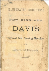 Flagstaff Hill Maritime Museum and Village
Book - Instruction Manual, Illustrated Directions for using the New High Arm Davis Vertical Feed Sewing Machine, 1883-1885
This book of Illustrated Directions was produced for use with the Davis New High Arm Vertical Feed (VF) Sewing Machine. The first model of the High Arm was produced in 1881, and the ‘New’ model, Model 2 VF, was introduced from 1883 and continued at least until 1885, when the Model 3 VF was manufactured. Job Davis, an inventor, showed his Davis Sewing Machine to two brothers in Watertown. The brothers, John and Joseph Shaldon, who founded the Davis Sewing Machine Company in February 1868 in Watertown, New York. The firm moved to Ohio in the 1890. Its early sewing machines were known as the Vertical Feed machines. These machines differed from others, in that there were two presser feet that moved and held the cloth as the needle went in and out of it. This type of action was also called ‘walking foot’ by makers of similar machines. Other machines used a feed dog below the machine’s bed to move the fabric. The Davis Company was awarded a Patents for its improvement to sewing machines. London offices were set up at 54, Queen Victoria Street, London in 1982. It was known as the Vertical Feed Sewing Machine Company. An article published in March 1885 states that the London Manager of the Vertical Feed Sewing Machine Company has 300,000 machines world-wide, including 4,000 in England alone. It claimed that the Auxiliary Forces Uniform and Equipment Company in Limerick, Ireland, was running its machines with steam power and could produce first-class work at the rate of 1,500 stitches per minute. The hand stitched binding of the manual is an example of early book binding processes. The is significant for its relationship to the Davis New High Arm Vertical Feed sewing machine, which was invented in 1866 and became popular in the domestic market. It was also used in industrial conditions as a labour-saving machine, one of the many machines that were part of the Industrial Revolution when steam power replaced manual power in many factories. Paper book with stitched binding. Printed text and illustrations contained within the 42-page booklet. The manual includes drawn diagrams and instructions for use of the Davis New High Arm Vertical Feed Sewing Machine, a foot treadle machine made in the 1880s. Front cover: "ILLUSTRATED DIRECTIIONS for the NEW HIGH ARM DAVIS Vertical Feed Sewing Machine and its Accessories and Attachments"flagstaff hill maritime museum and village, great ocean road, shipwreck coast, sewing machine manual, davis sewing machine, new high arm sewing machine, model 2 vf, vertical feed, sewing machine instructions, sewing machine directions, job davis, john sheldon, joseph sheldon, high arm sewing machine, watertown, new york, vertical feed sewing machine company, treadle, steam sewing machine, auxiliary forces uniform and equipment company, limerick, ireland -
 Flagstaff Hill Maritime Museum and Village
Tool - Tilting Saw Bench, W F & John Barnes, 1874 to 1880
he subject item is a pedal-powered rip saw with a tilting table made in the USA by W.F. & John Barnes Co. of Rockford, Illinois, between 1874 and 1890. The saw's blade moves rapidly in a circular motion and is driven by a pedal that spins a heavy flywheel with a leather belt attached to a gear drive that in turn drives the circular saw blade. The operator holds a wood workpiece on the table and moves it forward so the blade cuts it to the desired width and length. Company History: WF & John Barnes Co. was established in 1869, by making a formal partnership between William F. Barnes and John Barnes in 1872, and then incorporating in 1884. This company was an early manufacturer of pedal-powered equipment. By 1881 they were also making powered machinery such as lathes and pedestal drills. Many companies were making lightweight foot-powered equipment, but Barnes and the Seneca Falls Co. were the only ones to also make professional-grade workshop machines. From the beginning of their existence, they focused on pedal-powered machinery and specialised in making scroll saws. By 1937 the company focus had completely shifted to automotive assembly machinery, and custom-built machinery, machine tools, electrical, hydraulic, and mechanical controls and systems, including nuclear hardware. their production of foot-powered machinery had ceased. In the intervening years, they have got out of manufacturing completely. After a series of ownership changes, their equipment parts and stock were purchased in 1998 by LeBlond Ltd. of Amelia, Ohio. An item that although incomplete gives a snapshot into the manufacture and use of early woodworking machinery before the introduction of electricity or electric motors to power machines.A Treadle powered tilting table saw benchWF & J Barnes, Rockford Ill USA flagstaff hill, warrnambool, shipwrecked-coast, flagstaff-hill, flagstaff-hill-maritime-museum, maritime-museum, shipwreck-coast, flagstaff-hill-maritime-village -
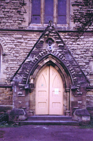 St Kilda Historical Society
Photograph, Christ Church St Kilda exterior - images collection #2
Christ Church was constructed in 1854-57 and designed in Decorated Gothic style by Albert Purchase & Charles Swyer. It was enlarged in 1874 and 1881 to the designs of Sydney W Smith. It is one of four main buildings constructed on land granted to the Church of England in 1855 and named Church Square. The other buildings are the bishop's residence, vicarage and parish hall. Heritage Victoria describes it as a 'rare and significant square in the history of town planning in Victoria which demonstrates the importance of the church to the community'. It is built from rarely used undressed random coursed sandstone from Point King Sorrento. It is located at 14 Acland Street, St Kilda. The triangular rose window is said to have been modelled on Lichfield Cathedral and shows outstanding craftsmanship. According to Heritage Victoria, the only other known example in Victoria is at St Georges Presbyterian Church in East St Kilda, designed by the same architect, Albert Purchas. The Church has a varied collection of stained glass, including work by leading stained glass firms and artists in Victoria in the nineteenth and early twentieth century: Ferguson & Urie, William Montgomery and Brooks Robinson. The 'shipwreck window,' north west transept, is an historically significant memorial window dedicated to Miles and William Dalzell Nicholson, the second and third sons of the Hon. William Nicholson, M.L.A, a Lord Mayor of Melbourne and Premier of Victoria in the 1850s. Miles, died in England on 27 April 1874. His younger brother William died in the wreck of the ‘British Admiral’ off King Island on 23 May 1874. The images show the condition of the church at the time they were taken (c 2012). Signs of deterioration can be seen. The bell is not rung any more because of damage to the stonework.There has been some remedial work since and the National Trust of Australia conducted a heritage restoration appeal.churches, acland street, purchase, swyer, st kilda, christ church -
 Uniting Church Archives - Synod of Victoria
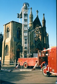
16 August 1988
The foundation stone for the Cairns Memorial Church in East Melbourne was laid on 20 November 1882, and construction began in 1883 to a design produced by architects Reed, Henderson and Smart of Melbourne. The church was named in memory of the Rev. Dr. Adam Cairns (1802-1881), late pastor of Chalmers Church on Eastern Hill. Cairns was born in Scotland and ministered there until coming to Melbourne in 1853, where he served as a minister until 1876. The church in East Melbourne was intended to accommodate those who had seceded from Chalmers Church and formed themselves into a new charge. The original design for 'a handsome and commodious edifice in the early English Gothic style capable of seating 750 persons' was described and illustrated in The Australasian Sketcher (January 1883). The interior was to be octagonal in form, with the organ and choir placed in the southern transept. The first portion of the church was opened in November 1883, but was soon found, under the popular ministry of the Rev. G.D. Buchanan, to be too small for the congregation. A new design by the architects Twentyman and Askew was developed, and the first part of the redesigned building was opened on 5 October 1884. The completed building was opened on 17 April 1887. Built from Barrabool Hills stone with Waurn Ponds freestone dressings, it consisted of a nave and transepts, with raking floor, a substantial undercroft and the base of an incomplete tower and spire to the north-west. The church was gutted by fire in August 1988 and was subsequently redeveloped as an apartment complex. The congregation of Cairns Memorial now worships at Richmond-Collingwood, or at St. Michael's Collins Street. Colour photo showing the partial demolition of the Cairns Memorial Church in Powlett St. East Melbourne after it had been destroyed by fire on 15 August 1988.cairns memorial, dr adam cairns, chalmers church, powlett st. east melbourne, australasian sketcher, reed henderson smart, gothic style, presbyterian, twentyman askew -
 Uniting Church Archives - Synod of Victoria
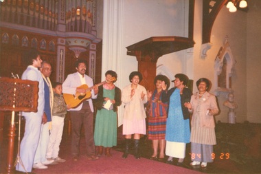
Photograph, 29 September 1984
The foundation stone for the Cairns Memorial Church in East Melbourne was laid on 20 November 1882, and construction began in 1883 to a design produced by architects Reed, Henderson and Smart of Melbourne. The church was named in memory of the Rev. Dr. Adam Cairns (1802-1881), late pastor of Chalmers Church on Eastern Hill. Cairns was born in Scotland and ministered there until coming to Melbourne in 1853, where he served as a minister until 1876. The church in East Melbourne was intended to accommodate those who had seceded from Chalmers Church and formed themselves into a new charge. The original design for 'a handsome and commodious edifice in the early English Gothic style capable of seating 750 persons' was described and illustrated in The Australasian Sketcher (January 1883). The interior was to be octagonal in form, with the organ and choir placed in the southern transept. The first portion of the church was opened in November 1883, but was soon found, under the popular ministry of the Rev. G.D. Buchanan, to be too small for the congregation. A new design by the architects Twentyman and Askew was developed, and the first part of the redesigned building was opened on 5 October 1884. The completed building was opened on 17 April 1887. Built from Barrabool Hills stone with Waurn Ponds freestone dressings, it consisted of a nave and transepts, with raking floor, a substantial undercroft and the base of an incomplete tower and spire to the north-west. The church was gutted by fire in August 1988 and was subsequently redeveloped as an apartment complex. The congregation of Cairns Memorial now worships at Richmond-Collingwood, or at St. Michael's Collins Street. Colour photo showing a group of Fijians singing to a guitar accompaniment in the apse of the Cairns Memorial Church East Melbourne.cairns memorial, dr adam cairns, chalmers church, powlett st. east melbourne, australasian sketcher, reed henderson smart, gothic style, presbyterian, twentyman askew, fijians -
 Uniting Church Archives - Synod of Victoria
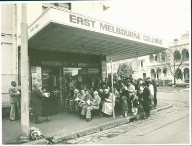
Photograph, 21 August 1988
The foundation stone for the Cairns Memorial Church in East Melbourne was laid on 20 November 1882, and construction began in 1883 to a design produced by architects Reed, Henderson and Smart of Melbourne. The church was named in memory of the Rev. Dr. Adam Cairns (1802-1881), late pastor of Chalmers Church on Eastern Hill. Cairns was born in Scotland and ministered there until coming to Melbourne in 1853, where he served as a minister until 1876. The church in East Melbourne was intended to accommodate those who had seceded from Chalmers Church and formed themselves into a new charge. The original design for 'a handsome and commodious edifice in the early English Gothic style capable of seating 750 persons' was described and illustrated in The Australasian Sketcher (January 1883). The interior was to be octagonal in form, with the organ and choir placed in the southern transept. The first portion of the church was opened in November 1883, but was soon found, under the popular ministry of the Rev. G.D. Buchanan, to be too small for the congregation. A new design by the architects Twentyman and Askew was developed, and the first part of the redesigned building was opened on 5 October 1884. The completed building was opened on 17 April 1887. Built from Barrabool Hills stone with Waurn Ponds freestone dressings, it consisted of a nave and transepts, with raking floor, a substantial undercroft and the base of an incomplete tower and spire to the north-west. The church was gutted by fire in August 1988 and was subsequently redeveloped as an apartment complex. The congregation of Cairns Memorial now worships at Richmond-Collingwood, or at St. Michael's Collins Street. B & W photograph showing the congregation of the Cairns Memorial Church attending a service held under the verandah of the East Melbourne Cellars (Cheers Bottle Shop) after fire had destroyed their church on 15 August 1988.cairns memorial, dr adam cairns, chalmers church, powlett st. east melbourne, australasian sketcher, reed henderson smart, gothic style, presbyterian, twentyman askew, fijians, east melbourne cellars, cheers bottle shop -
 Stawell Historical Society Inc
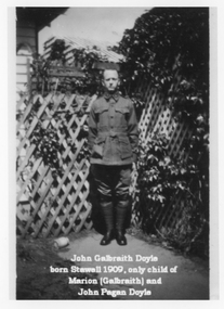
Photograph, Doyle Family Photos with Indentifying names -- 7 Photos
Doyle Family Group photographs plus others. Think a mistake in photograph of soldier in WW1 uniform (photo 2) as more likely Peter Pagan Doyle as John born 1909. Photo 1. Portrait of "John Galbraith Doyle born Stawell 1909, only child of Marion (Galbraith) and John Pagan Doyle". Photo 2. of soldier & portrait photo. "John Galbraith Doyle born Stawell 1909 only child of Marion (Galbraith) and John Pagan Doyle". Photo 3. of wedding group "Origin unknown. At the right is Marion Galbraith, b1881 in Stawell, dau. of Peter Galbraith. The man to her right is thought to be John Pagan Doyle". Photo 4. of house. "Home of Peter Galbraith and family, possibly Patrick Street Stawell. with family members arrayed" Photo 5. family group "Galbraith family at Stawell. Mr. Peter Galbraith, his wife Margaret (Cameron), and 4 children -L-R Norman, Marion, Afton and (in front) Harold. Photo 6. of 8 men. "Source unknown, but possible connected with Stawell of Mines or may be part of Peter Galbraith's assay business. People second from left, back row and second from left, front row appears to be sons of Peter Galbraith". Photo 7. "Marion (Galbraith) Doyle and John Galbraith Doyle (b. Stawell 1909)". Marion only daughter of Peter & Margaret Galbraith nee Cameron born Stawell 1881. Marion married John Pagan Doyle who was Science Director of School of Mines, Stawell 1909. Eight black and white photographs of Galbraith Doyle and Pagan Doyle Family. Two photographs of a soldier in WW1 uniform. (Think a mistake as possible Peter Pagan Doyle). Third photo is of a group of 13 people at a wedding. Fourth photo of a weather board house with a veranda and garden and people on veranda and in garden. Fifth photo Family group. Sixth photo 8 men holding equipment associated with mining but formally dressed. Eight photo of a woman and child holding a cat. Note a mistake on 2 photos, the captions state John Galbraith Doyle was born 1909 at Stawell but he is shown in a WW1 uniform which cannot be him. The soldier must be his father John Pagan Doyle who enlisted 1915 at Stawell. Photo 1. of "John Galbraith Doyle born Stawell 1909, only child of Marion (Galbraith) and John Pagan Doyle". Photo 2. of soldier & portrait photo. "John Galbraith Doyle born Stawell 1909 only child of Marion (Galbraith) and John Pagan Doyle". Photo 3. of wedding group "Origin unknown. At the right is Marion Galbraith, b1881 in Stawell, dau. of Peter Galbraith. The man to her right is thought to be John Pagan Doyle". Photo 4. of house. "Home of Peter Galbraith and family, possibly Patrick Street Stawell. with family members arrayed" Photo 5. family group "Galbraith family at Stawell. Mr. Peter Galbraith, his wife Margaret (Cameron), and 4 children -L-R Norman, Marion, Afton and (in front) Harold. Photo 6. of 8 men. "Source unknown, but possible connected with Stawell of Mines or may be part of Peter Galbraith's assay business. People second from left, back row and second from left, front row appears to be sons of Peter Galbraith". Photo 7. "Marion (Galbraith) Doyle and John Galbraith Doyle (b. Stawell 1909)".stawell -
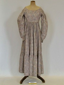 Brighton Historical Society
Clothing - Dress, Day dress, circa 1820
This dress, which was made around 1820, was passed down through five generations of a single family before its donation to Brighton Historical Society in 2007. It originally belonged to a great-grandmother of Margaret Reynolds (1881-1958) of Hertfordshire, England, who herself came into possession of the dress around the early twentieth century. Having no daughters of her own, in 1945 the 64-year-old Margaret sent the dress as a Christmas gift to her niece, Margaret Willoughby Reynolds (1907-1996). In the letter accompanying the parcel, donated to the Society with the dress, the elder Margaret writes that she loves the dress very much but has now outgrown it. She makes reference to her own mother Mary Reynolds (nee Lloyd)'s pleasure at seeing the dress worn, indicating that it may originally have belonged to one of Mary's grandparents. She had two requests of her niece: first, that the younger Margaret wear the dress on Christmas Eve as a treat for her Mary (the letter includes styling advice on how the dress should be worn and accessorised), and second, that she one day pass the dress on to her own daughter or niece. In March 1968, the younger Margaret gifted the dress to her Australian-born niece, Dorothy May England (nee Reynolds, 1924-2013), along with a letter of her own. Dorothy, a Bayside resident, donated the dress and both letters to the Society in 2007. The letters paint a picture of the significance of the dress within the Reynolds family and its journey from England to Australia.A white, mauve, purple, red, and green paisley / floral printed cotton day dress from circa 1820. The day dress features a wide scooped neckline, with a dropped shoulder line. At the head of the sleeve is has three lines of gathering creating a narrow arm hole around the shoulder, flaring out into a leg of mutton sleeve. The sleeve finishes neatly at the wrist with a cuff that secures with two brass hook and eye closures. The dress bodice is open at the centre front and secures with six hook and eye closures to the empire line waist. Over the breast on either side of the opening are six diagonal pleats, pressed and secured facing towards the neck. This pleated detail is on a facing that extends from shoulder to shoulder and finishes with a bound edge. The remainder of the front bodice is plain and secures to the skirt at the empire waistline. The skirt pleats onto a binding, wrapping around the torso and securing to the bodice with eight hook closures. At approximately knee, height the skirt has an additional gathered flounce with the dress finishing at approximately ankle length. From the back, the bodice is plain and the skirt is gathered and sewn to the bodice at Empire line. Alterations to the garment have been made with the addition of hooks and eyes. The garment is generally in good condition although the skirt at the front shows evidence of damage and subsequent repair.day dress, 1820s, migration, dorothy may england, margaret willoughby reynolds, margaret reynolds -
 Bendigo Historical Society Inc.
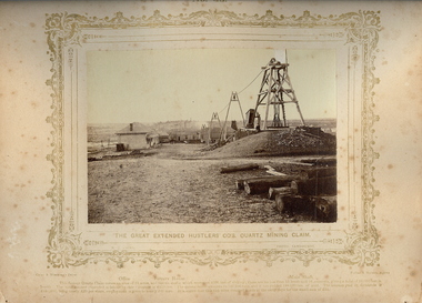
Photograph - VIEWS OF BENDIGO: THE GREAT EXTENDED HUSTLERS CO'S QUARTZ MINING CLAIM, 1875 copy,1970
Sepia photo on cream board. Shows the Great Extended Hustlers Co's. Quartz Mining Claim. In photo, there is an Office, Battery House, Mine Shaft. Three large 'A' frames running a line down to the battery house from the poppet head. Inscription: Above image: 'Views of Bendigo|No.43.'. Below, 'The Great Extended Hustlers Co's. Quartz Mining Claim.', 'N.J.Caire Photo, Sandhurst'. Bottom, 'Casey & Wenborn's Print Forbes & Holmes, Agents',' Office Battery House Main Shaft',' The famous Quartz Claim covers on area of 24 acres, and has six shafts which represent 4000 feet of sinking; there are no less than 13 level and 16 crosscuts, giving a total of 12,000 feet in length. The total amount expended in labour by this Company £228,000. The Quartz raised amounts to 144,500 tons, and it has yielded 188,000 oz's of gold. The amount paid in dividends is £585,600 being nearly £20 per share, employment is given to nearly 200 men. It is stated that this rich mine changed hands in early days for the small sum of £30.'. On Back, RHSV stamp, Bendigo Branch '1959|186'. Nicholas CaireN.J.Caireplace, mining site, great expended hustler quartz mine, see: 'views of bendigo' by n.j.caire -
 Bendigo Historical Society Inc.
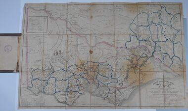
Document - HARRIS COLLECTION: HAMS SQUATTING MAP OF VICTORIA, PORT PHILLIP DISTRICT, NSW
Thomas Ham was a cartographer, engraver, lithographer and publisher in Victoria and Queensland. He compiled and printed several editions of his squatting map, beginning with A map of Australia Felix in 1847 and changing its title to Ham's squatting map of Victoria in 1851. The 1851 edition was accompanied by a key listing the names of all the squatters within squatting districts and counties. Later editions show the existing counties, but some areas of Gippsland and the Australian Alps are still described as 'unsurveyed country'. (State Library Victoria https://www.slv.vic.gov.au/squatting-map-victoria)Folding map enclosed in burgundy cover. Map backed by cloth and bound. Rare, early map of Victoria and neighbouring Port Phillip District of New South Wales. Written on bottom RH corner of map: Ham's Squatting Map of Victoria ( Port Phillip District, New South Wales ) carefully corrected to this date from the Colonial Government Surveys, Crown Lands, Commissioners & Explorers Maps, Private Surveys & c. Respectfully inscribed (with permission ) to His Excellency Sir Chas A. Fitz-Roy Knt, Governor of New South Wales &c &c by his Obedient Servant, The Compiler, 1851. Compiled, engraved and published by Thomas Ham, Melbourne. Proposed and original boundary ( in legend) have been coloured in in blue and pink ink ( later addition ?) Number on map show 'reference to proprietor's Printed on back of map ' J.G. AD 1852, with two cross hatched decorations and two hearts entwined. On other back panel in pencil enclosed in a drawn frame ' G.S.H., 1889, Axedale' (George Harris, Axedale, belongs in Harris Collection) Stamped in purple ink 'Royal Historical Society of Victoria, Bendigo Branch. Written 1959, 53.map, victoria, squatting map