Showing 10533 items
matching lander
-
 Flagstaff Hill Maritime Museum and Village
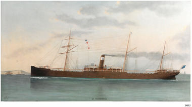
Photograph - Vessel, S.S. Warrnambool, 1998-2003
This photograph and a matching earlier photograph are the images of a painting of the British steamship SS Warrnambool at Dover Strait in the English Channel. The photographs were donated by the painting’s owner, who acquired the 30” x 56” (76 x 142.5 cm) oil on canvas painting in 1998. Both photographs were accompanied by a letter, one written in 2001, and the other in 2003. The letters confirm that the artist of the painting was Charles Keith Miller, signed with the initials “CKM” and dated “1893”. The painting shown in the photographs was a gift to the Town Council of Warrnambool, presented to Warrnambool folks in Melbourne on December 1, 1892, by the Captain of William Lund’s ship SS Warrnambool. The painting was given by Lund in appreciation of the Ladies of Warrnambool who had presented the ship with a ‘house’ flag bearing the Blue Anchor Line’s symbol of a diagonal blue anchor on a white background; the ladies had made the decision to present the flag only a month earlier. A few days later, December 6th, the SS Warrnambool was on its homeward journey to Britain, sailing via Adelaide. It anchored for a short time off the Port of Warrnambool. A boat was launched from Lady Bay to take a group of friends to the ship with a delivery of gifts. After cheers were roused for both the ship and the Captain, the ship continued on its way. The photograph shows the gifted white flag with a diagonal blue anchor flying from the masthead. The same symbol is painted on the ship’s black funnel. The signal flags on the foremast display ‘M’ ‘R’ ‘V’ ‘B’. These letters are most likely the ship’s call number ‘MRVB’. Although the painting was given as a gift in December 1892, it is post-dated “1893”. Perhaps the painting was given earlier than anticipated; or the date added later, but whatever the reason, the provenance of the painting was confirmed at auctions of this painting and other works by the same artist. CHARLES KEITH MILLER 1836-1907:- Captain Charles Miller left his home in Scotland at the age of 15 years for a life at sea. He earned his Master’s Certificate ten years later. After being the captain of sailing ships he moved over to the steamships because they were faster. In 1866 he married and settled in Glasgow. Over the following eleven years he and his wife had five children, then sadly his wife passed away. Captain Miller returned to the sea for a while but in 1888 he gave up his sea life to spend his time as a marine artist. His understanding of seafaring life and vessels, combined with his artistic skills, gave him the ability to produce fine art and several galleries and museums have collections of his sought-after works. S.S. WARRNAMBOOL 1892-1925:- The steamship SS Warrnambool was built in 1892 by the Sunderland Ship Building Company for the Lund Line of London, founded by William Lund in 1869. It efficiently carried both passengers and cargo across the world to Australia, under the command of her master Captain Joshua Edward Iibery, who had many years of experience with the Blue Anchor Line. The company, referred to as the Blue Anchor Line or BAL, owned a fleet of both sail and steamships. The funnels of all of the steamships were painted black, with a white band around the top bearing a diagonal blue anchor and chain. The company’s house flag was also white with a diagonal blue anchor. The SS Warrnambool carried passengers and cargo in a ‘no frills’ service to and from Europe around the Cape of Good Hope, stopping at some ports in between. The ship was involved in bringing home returned solders in 1895. At one time it carried a doctor from Victoria, Australia, to assist at the war front in South Africa. The ship had a very good reputation for its cargo arriving ‘almost always in excellent condition.’ Exported goods from Australia included iron safes, flour, wool, apples, frozen rabbits, butter, cheese, pork, cattle, poultry and sheep. One remarkable delivery contained Ostriches for Queen Victoria and they survived the journey well. The SS Warrnambool was sold in 1900 to the British and South American Steam Navigation Co. Ltd of Liverpool and was renamed ‘Harmodius’. The company was managed by R.P. Houston & Company of London and its Houston Line funnels were red with a black top. The Harmodius was sold in 1919 to K.S.S. Co. Ltd, managed by Kaye Son & Co. Ltd. of Liverpool, and was renamed ‘Kut’. The line had black funnels with a white ‘K’ in a diamond or between white stripes. In 1926 it was purchased by T.W. Ward Ltd. and broken up. NOTE- other vessels named “Warrnambool” Two other vessels carried the name “Warrnambool” (1)- HMAS Warrnambool J202 (1941-1947), a Bathurst Class corvette vessel owned by the Royal Australian Navy, destroyed by a mine. The photograph is significant for its association with the painting "SS Warrnambool" by well-known early 20th century marine artist Charles Keith Miller, whose paintings are well valued. The painting and the photograph of it are namesakes of Warrnambool and are connected through the gifts exchanged between the ship company owner, the City of Warrnambool and the Ladies of Warrnambool; the House Flag and the painting by C K Miller. The image is a good likeness to original photographs of the late-19th to early-20th century steam and sale vessel. Coloured photograph of a painting, the steamship S.S. Warrnambool. The three-masted ship has lowered sails. It is in calm water, land on one side, and other vessels in the water. The ship has four raised signal flags, a house flag and a blue ensign. The funnel also bears the house flags symbol. Smoke emits from the funnel. Figures are visible onboard. There is a signature and a title on the lower edge of the photograph. (Artist of the painting in the photograph was Charles Keith Miller)House flag symbol, [diagonal blue anchor on white background] Text "CKM" and "1893" Text "S. S. WARRNAMBOOL."flagstaff hill, warrnambool, photograph, steam ship warrnambool, flagstaff hill maritime village, shipwreck coast, ss warrnambool, captain, charles keith miller, ckm, 1893, william lund, warrnambool town council, blue anchor line, lund line, ladies of warrnambool, house flag, diagonal blue anchor, captain miller, sunderland ship building company, migrant ship, 1892 ship, home flag, bal, australian export, s.s.warrnambool, dover strait, english chanel, port of warrnambool, lady bay, mrvb, captain charles miller, captain joshua edward iibery, ostriches, queen victoria, british and south american steam navigation co., harmodius, r.p. houston & company, houston line, k.s.s. co. ltd, kaye son & co. ltd, kut, t.w. ward ltd -
 Glenelg Shire Council Cultural Collection
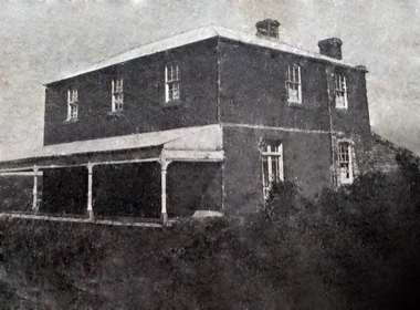
Artwork, other - Engraving / Illustration, n.d
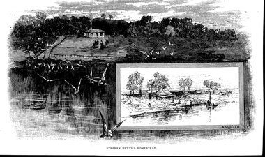
Illustration. Depiction of Steven Henty's homestead, overlooking Portland Bay (view from sea, looking towards land). The dwelling is on the top of a hill with smoke coming out of the chimney and a group of people in front. Birds in flight in the foreground. There is a smaller bordered illustration on the bottom right-hand corner featuring a number of small dwellings near water, two people on a boat and a number of people on the foreshore. Image has been cut from a book, text on reverse of the image.STEPHEN HENTY'S HOMESTEAD Signature in left hand side of main image and signature of the right-hand side of the border of the smaller image. Both are illegible.first european settlers, henty, stephen henty -
 Kiewa Valley Historical Society
Map - Kiewa on the Map, Guide to Kiewa Hydro-Electric Project
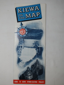
Published by the SECV in 1950. They controlled the roads from Mt Beauty to the Bogong High Plains and all other roads within the Kiewa works area. The roads are not open to general tourist traffic. Conducted tours of the Kiewa area are operated by Eastern Road Lines Pty. Ltd., AlburyThe SECV constructed the KHES and controlled all roads within the Kiewa works area.Large colored map folded in half and then in 3. Front third is mostly blue and white with titles.. When opened the cover has black and white photos beside it with print and 'Please Note'. Also in the other half, a 'Road Map to Kiewa' showing the south eastern side of Australia, mostly yellow (the land) and blue (the sea). Inside the map is a close up map of "Ground Plan of Kiewa Hydro Electric Project' with a 'Key Map Showing Distances'.map of kiewa 1950, khes map -
 Bendigo Historical Society Inc.
Document - H.A. & S.R. WILKINSON COLLECTION: CONTRACT OF SALE
Conditions of sale by private contract dated 19th October, 1942 between D.R. Hay (seller) and H.A. Stirton (buyer) for land situate corner Creek and Hamann Streets, Bendigo, having a frontage of 85 links to Hamann Street by a depth of 134 links to Creek Street and adjoining allotments 6 and 4, and described in right to occupy residence area title No. 5429, together with 4-roomed weatherboard dwelling and all sundry. Price 270 pounds.organization, business, h.a. & s.r wilkinson real estate -
 Bendigo Historical Society Inc.
Document - H.A. & S.R. WILKINSON COLLECTION: CONTRACT OF SALE
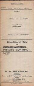
Conditions of sale by private contract dated 19th October, 1933 between Mrs. P.I. Clark (seller) and Miss M. Thompson (buyer) for land situate McIvor Road, Bendigo being lots 2,5 and 6 on plan of subdivision No. 13539 and being Crown allotment 196 and parts of Crown allotments 151,195 and 270A section H described in certificate of title volume 5756 folio 1151098, together with all fences and erections thereon. Price 150 pounds.organization, business, h.a. & s.r wilkinson real estate -
 Bendigo Historical Society Inc.
Document - H.A. & S.R. WILKINSON COLLECTION: CONDITION OF SALE
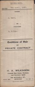
Conditions of sale by private contract dated 7th April, 1943 between J. Kett (seller) and L. R. Toy (buyer) for all those pieces of land situate Panto Street Eaglehawk, being allotments 3,5 and 6 section 13A at Eaglehawk, having a frontage of 100 links to Panton Street and described in certificate of title volume 5159 folio 1031735, together with 7-roomed brick and weatherboard dwelling and all sundry. Price 400 pounds.organization, business, h.a. & s.r wilkinson real estate -
 Bendigo Historical Society Inc.
Document - H.A. & S.R. WILKINSON COLLECTION: CONTRACT OF SALE
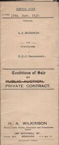
Conditions of sale by private contract dated 17th June, 1930 between A.G. McKenzie (seller) and E.G.S. Rasmussen (buyer) for land situate Havlin Street, Bendigo adjoining Mr. J. Bennett's property and occupied by Mr.. Price as tenant, being part of Crown allotments 392 and 393 section 8 described in certificate of title volume 5514 folio 1102695, together with 5-roomed weatherboard dwelling and all sundry. Price 775 poundsorganization, business, h.a. & s.r wilkinson real estate -
 Bendigo Historical Society Inc.
Document - H.A. & S.R. WILKINSON COLLECTION: CONDITION OF SALE
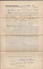
Memorandum of agreement dated 21st May, 1924 between Mr. H. Wilkinson (landlord) and Mrs. M. Hodge (tenant). The tenant agrees to take from the landlord the land & premises situate in Mundy street Bendigo and last occupied by Spencer at the weekly rent of 1 pound and 1 shilling payable fortnightly, such tenancy to commence on the 26th May, 1924 and not cease until 1 week notice in writing shall have been given by either party to the other.organization, business, h.a. & s.r wilkinson real estate -
 Bendigo Historical Society Inc.
Document - EXTRACT FROM UNKNOWN SOURCE: CHARLES SHERRETT, MOUNT ALEXANDER
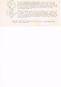
Extract from unknown source re Charles Sherrett, Mount Alexander. This typewritten two paragraphs related to a letter from Captain Lonsdale to the Colonial Secretary (1840) re depasturing of stock on Crown Land at Port Phillip, licences and the mention of Charles Sherrett ''travelling to Mount Alexander'' as place of residence. In a handwritten (crossed out??) note to the side of this typewritten extract is the following: ''Letter of the Town Clerk Bgo 1929 re correct date to celebrate centenary''.document, memo, report, captain lonsdale. licences. charles sherrett.. -
 Bendigo Historical Society Inc.
Document - H. A. & S. R. WILKINSON COLLECTION: CONTRACT OF SALE
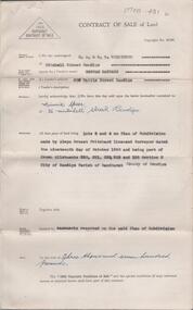
Contract of sale of land dated 29th November, 1950 between Miss H. Barrass (vendor) and Mrs. M. Speer (purchaser). Property: lots 3 and 4 on plan of subdivision made by Alwyn Ernest Pritchard Licensed Surveyor dated the 19th of October, 1950 and being part of Crown allotment 230, 231, 232, 233 and 125 section H, Parish of Sandhurst City of Bendigo. Price: 3,700 pounds. Attached 8 hand written notes.organization, business, h.a. & s.r wilkinson real estate -
 Bendigo Historical Society Inc.
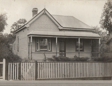
Photograph - T C WATTS & SON COLLECTION: HOUSE 21 RUSSELL STREET, BENDIGO, C1929
Thomas Crouch Watts was born on March 7th. 1865, to Joseph and Susan Watts. Before the real estate business commenced, Thomas and his brother were in partnership as booksellers and stationers in a shop at View Point. Thomas lived in a fine house in Rowan Street, which was called 'Ottawa' Thomas started his real estate business in the early 1900s in a shop in View Street. His daughter Edna was the book keeper and typist, Stewart Watson was the salesman and Stanley Phipps (Edith Lunn's father) was the property manager and valuer. When Thomas Watts died in 1914, his daughter took over the running of the business. She married Stewart Watson in 1918. Eventually the name of the business was changed to Bishop and Earl. From a letter from Edith Lunn re T.C. Watts & Son. 'The firm of T.C. Watts & Son later became Bishop and Earl. When the firm of Bishop and Earl ceased to operate after the death of Edith Lunn's father, S.P. Bishop, Miss. June Parry, Secretary of the BHS was a member of staff. June rescued all the photos of properties listed for sale from the office and placed them into the custody of the BHS.' Black and white original photograph mounted on rectangular grey board. House, weatherboard, corrugated iron roof, gableroof LH side, bullnose verandah, wooden fence, one chimney. On back of photo ' Ferguson, 21 Russell Street, Bendigo.£ 500. ' £525 for house, and £600 for whole of land through to Houston St. 24.7.34' Stamped with T.C. Watts & Son. Sticker attached to bottom of photo board ' April 1929, 21 Russell Street, Bendigo. £750'Frank A. Jeffree, Photo, Bendigo Victoria.place, building, residential, t c watts, real estate -
 Bendigo Historical Society Inc.
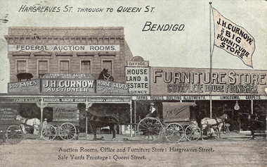
Photograph - HARGREAVES AND QUEEN STREETS, 2nd June 1908
Hand-coloured postcard, Hargreaves through to Queen Streets, Bendigo. Three covered horse-drawn wagons with drivers, in front of Federal Auction rooms, Furniture Store. Large flag on pole - 'J.H. Curnow the Big Furniture Store', 'Office, House Land and Estate Agency', 'Farms, houses, building allotments, linoleums, carpets'. Inscriptions/markings: printed on card - 'Auction Rooms, Office and Furniture Store - Hargreaves Street, Sale Yards Frontage Queen Street.place, streetscape, hargreaves street -
 Bendigo Historical Society Inc.
Document - NORMAN OLIVER COLLECTION: SPEECH NOTES
The Norman Oliver collection. Norman Oliver was three times Mayor of Bendigo - 1950-51, 1964-65, 1970-71. Twenty pages of typed notes for his radio talk. Undated, but in a bundle with others dated 1950-51. Corrections in blue ink. Topics include: flooding in Bendigo, the Engineer's Report, the Aerodrome and land reclamation, decentralised industries, street trees, noxious trades, the Medical Officer's Report, weights and measures, garbage, and new engineering staff.bendigo, council, speech notes, norman joseph oliver , councillor norman oliver. mayor of bendigo. 3bo -
 Ballarat Tramway Museum
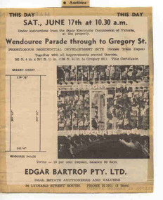
Newspaper, The Courier Ballarat, This Day Auction Notice, 17/06/1972 12:00:00 AM
Newspaper clipping from The Courier, Ballarat, dated Saturday, 17 June 1972 real estate advertisement, This Day Auction Notice, advising that the former SEC depot in Wendouree Parade is to be sold at 10.30am. Agent - Edgar Bartrop. Features an aerial photograph with the site and streets marked on it, along with the dimensions of the land to be sold. One of a large group of newspaper cuttings from John Bainbridge, 7/4/02. See Reg Item 2770 for Bartrop's handout.depot, buildings, auctions, bartrop -
 Bendigo Historical Society Inc.
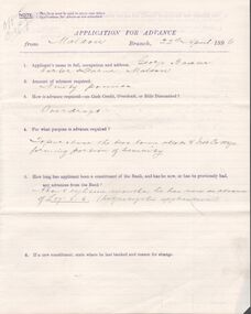
Document - Mortgage and cash credit bond
Copy of a cash credit bond between George Baxter, carter, of Maldon and the bank of New South Wales for ninety pounds. Also, an application for advance and two copies of the mortgage documents. all the documents related to purchase of land in Maldon and are dated 22 April 1896. Also, a brown envelope addressed to The Manager bank of New South Wales, Melbourne from Geo Baxter, carter, Maldon "lapsed security" Some other writing in pencil on the envelope.maldon, mortgage, freehold, baxter, cash credit bond -
 Kew Historical Society Inc
Archive (Sub-series) - Subject File, D'Estaville (Barry Street), 1958
Various partiesReference, Research, InformationSecondary Values (KHS Imposed Order)Sir William Stawell built the house, D’Estaville, in what is now Barry Street, Kew. The subject file about the house includes sundry items including real estate brochures, newspaper articles/clippings, copies of Australian Heritage and the Victorian Historical Journal (2006) in which there are articles on Stawell and the Victorian Constitution, correspondence between the Society and the national Trust and the Historic Buildings Council relating to the vacant land in Sir William Street (1980) and to D’Estaville itself.d'estaville - barry street - kew (vic), sir william stawell, alma figuerola, historic houses - kew (vic)d'estaville - barry street - kew (vic), sir william stawell, alma figuerola, historic houses - kew (vic) -
 Melbourne Tram Museum
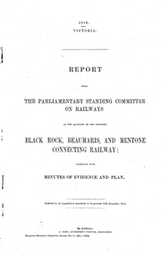
Document - Report, Victorian Parliament, "Report - The Parliamentary Standing Committee on the Proposed Black Rock, Beaumaris and Mentone Connecting Railway.", Dec. 1910
Printed - 10 page foolscap, stapled on left hand side, 2 sections, Victorian State Parliamentary Report titled "Report - The Parliamentary Standing Committee on Railways on the Proposed Black Rock, Beaumaris and Mentone Connecting Railway.", together with minutes of evidence, dated 19/12/1910 References the Black Rock tramway, background of the district, evidence, tramway or railway service, land acquisition, cost of railways or tramways, report from Traffic Officers, costs and recommendations.trams, tramways, sandringham, mentone, beaumaris, railways, tramways, proposals -
 Bendigo Historical Society Inc.
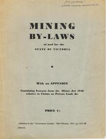
Book - AUSTIN COLLECTION: MINING BY-LAWS OF STATE OF VICTORIA 1958
BHS CollectionPale grey cover, booklet: mining By-Laws of and for the State of Victoria' Priced 1/- , containing extracts from the Mines Act 1958 relative to Claims on Private Land & etc. Written on top in pen 'P.E. Clarke, State Mining Engineer' 37 pages. Contains information regarding a wide range of mining practices e.g. 'dredging and sluicing claims' 'it shall not be lawful for any area exceeding five acres in extent to be held as a dredging claim or as a sluicing claim'.bendigo, mining, mining by-laws -
Bendigo Historical Society Inc.
Book - LANDS OFFICE: INDEX LANDS AND SURVEY
Index lands and Survey. Sandhurst, Kangaroo Flat, Eaglehawk, White Hills, And Nerring. Land Sales, Beginning April 17, 1854. The last entry is dated 23.9.74. markings on spine of book are at top 04 in black, in gold lettering index lands and Survey, in black Bendigo, Eaglehawk, Kangaroo Flat White Hills and Nerring, near the bottom is the letter B in black, a white sticker with the letters VV. Read in conjunction with 2239 (a to g), located in Box 77.lands office, index, survey -
 Warrnambool and District Historical Society Inc.
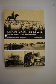
Book, StarPrinting Service Pty ltd, Soldiering On – Caramut and the Soldier Settler Movement, 2018
This book records the history of the post World War Two soldier settlement farms in the Caramut area. Number two in a series of books on Soldier Settlements in Western Victoria.This is a soft cover book of 315 pages. It has a buff-coloured cover with black and white photographs and white printing on the front cover and black printing on the spine. The book includes printed material, black and white photographs, maps and plans. non-fiction This book records the history of the post World War Two soldier settlement farms in the Caramut area. Number two in a series of books on Soldier Settlements in Western Victoria.james affleck, peterborough, soldier settlement, caramut, history of warrnambool, soldier settlement, caramut -
 Eltham District Historical Society Inc
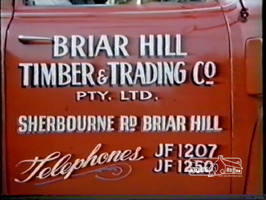
Film - Video (DVD), H.V. Plowman, Briar Hill Timber & Trading Co. Pty. Ltd, c.1956
Briar Hill Timber was associated with the Olympic Village Project being suppliers of all building materials including Flush Panel Doors, Mouldings and Joinery. Briar Hill Timber owned by F. Squire and the Squire family owned a lot of land around Briar Hill and land for forest at Flowerdale. The 16 mm film photographed by H.V. Plowman (converted to DVD) shows all aspects of the operations of Briar Hill Timber from logging of trees, to milling to manufacture of joinery and housing framesMP4 00:13:12; 247MB Converted from DVD converted from VHS video converted from 16mm colour filmbriar hill timber, f. squire, olympic village, 1956 olympic games, timber mill, flowerdale, cinematography, briar hill, h.v. plowman, logging, video recording -
 Greensborough Historical Society
Document - Folder, Peter Simmenauer, Hobson land, edited by Peter Simmenauer, 2018_07
Robert Hobson purchased 148 acres of land in Crown Portion 17 from the Crown Grantee John Brown in 1877, which was sold to George Knowles Parker and John Howard Aylwin in 1887. A major purchaser of this land east of the Greensborough Road was Mary Baird in 1929. Although Baird died in 1944, sales from her estate continued until 1956. The folder Includes relevant Old Law documents and Certificates of Title, as well as a list of sales of LP11599 allotments.Loose-leaf folder of documents - lists and plansrobert hobson, mary baird, hobson street greensborough -
 Orbost & District Historical Society
register, Register of Residence Areas, 10.2.1897 - 4.9.1934
This book is a register of land holders with miners' rights. The correspondence is associated with applications for miners' rights on privately owned land and business sites. They include application fotrms and objections to registrations. The areas referred to are Combienbar, Goongerah, Club Terrace, Wombat Creek and Dundong. One of the privileges under the Mines Act, conferred by the holding of a miner's right until 1935 was that of residence on up to one acre on a gold-fields area. Those occupying a residence area were "deemed in law to be possessed ... of such ... parcels ... and the property therein".This is a useful research tool.A large, heavy book with a grey cloth cover and red spine. The end papers are marbled. The inside pages are ruled in grey with red ruled columns. Entries are hand-written. There are copies of correspondence inside. Details given are the registration number and date, the name of the person, the number of the miner's right and its date, a description of the allotment and any remarks or references to other volumes. Any changes of ownership are shown. The book is mostly unused.register-mining miners-rights -
 Torquay and District Historical Society
Photograph (copy), Bellbrae Cemetery Memorial Exhibition 2015
Photograph shows Llanberris House, built by Joseph and Mary Gundry on Iron Bark Station, west of the Anglesea Geelong Road, off Menzels Road above Spring Creek. The Gundrys took up Iron Bark station in 1844 and subsequently bought up more surrounding land. Just prior to Joseph's death in 1878, the property comprising 7721 acres was offered for sale as well as conditional rights to adjoining land. Llanberis House was a substantial stone dwelling of 2 storeys with 11 rooms.The Gundry family was one of the pioneering European settlers in the Bellbrae Torquay area.Black and white photographbellbrae victoria pioneer families -
 Whitehorse Historical Society Inc.
Photograph, 443 Mitcham Road, Mitcham, 1998
Eric Roger Webb moved to Mitcham with his family in about 1932. They lived at 443 Mitcham Road and owned all the land up to Simpson Street. The land was a grass paddock and he planted native trees and shrubs around the perimeter. The Webbs has three children: Eric, Dean and Donald. Mr Webb worked in the public service. He was a councillor of the Shire of Blackburn and Mitcham and later of the city of Nunawading between 1940 and 1949. He was also a Shire President from 1943-1944.Coloured photograph of a house at 443 Mitcham Road, Mitcham. Tiled roof, verandah, path leading to front door.443 mitcham road, mitcham, houses, webb, eric -
 Bendigo Historical Society Inc.
Document - Fortuna Villa - The Past and the Future
Theodore Batterstedt and his father bought five acres of land on which they built a quartz crushing mill and a two storied, 8 roomed home in 1855. In 1869 they added 2 large rooms to each floor. In 1870 they sold the property to George Lansell. Further additions and renovations too place in 1888' 1890, 1900 and 1907. In 1942 the largely derelict building was compulsorily acquired by the army to house the Land Headquarters Cartographic Company and later the Army Survey Regiment.A 2 page document detailing the history of George Lansell's 'Fortuna' estate.george lansell, fortuna, military -
 Kew Historical Society Inc
Map, Robert Russell, Map Shewing the Site of Melbourne and the Position of the Huts & Buildings Previous to the Foundation of the Township by Sir Richard Bourke in 1837
Map shows the first layout of Melbourne by Government surveyor Robert Russell, who accompanied Governor Richard Bourke in 1837. The surveyed blocks extend from present-day Flinders Street to Lonsdale Street, and Spring Street to Spencer Street, with extensive vacant land west to a salt lake (afterwards Batman's Swamp, later drained), north beyond Flagstaff Hill and south towards South Melbourne. Vegetation coverage is indicated, and tracks and existing buildings and cultivated land are shown.Printed map was created by Day & Haghe, Lithographers to the Queen, sometime after 1838, when the company received its Royal appointment. Copies of the 1837 map exist in several major map collections in Australia; most are uncoloured. This particular map is the earliest in the Kew Historical Society's map collection. It is a nationally significant artefact. Black and white lithographed map hand-coloured in blue and yellow gouache of the town of Melbourne in 1837. In contrast to the original lithograph, the river and the township blocks are coloured blue and yellow. A similar, partly coloured copy is in the collection of the University of Melbourne.maps - melbourne - 1830s, governor sir richard bourke, robert russell - surveyor, cartography -
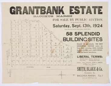 Bacchus Marsh & District Historical Society
Map - Land Sales Plan, Grantbank Estate Bacchus Marsh, 1924
The Grantbank Estate was a parcel of land close to the centre of the shopping area of Bacchus Marsh which was sub-divided and offered for sale in 58 lots on the 13th September, 1924. It comprised an area of 15 acres, being a portion of the Millbank Estate which had been in the hands of the Grant family for 75 years. The lots had frontages to Gisborne Road, Patterson, William and Sutherland Streets. This was a significant sub-division of land and represented a major expansion of residential housing in Bacchus Marsh in the early 20th century.This land sale map is a typical example of housing estate land sales advertising maps produced by real estate agents in this era. The map is significant for the detailed information it provides about when and where land was sold for new housing estates in Bacchus Marsh in the early twentieth century.Printed paper mapland sales bacchus marsh, land subdivsion bacchus marsh, housing estates land sales bacchus marsh, grant family bacchus marsh -
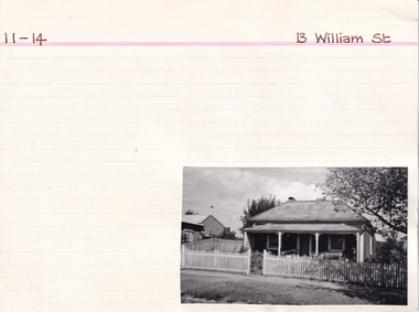 The Beechworth Burke Museum Research Collection
Card (Series) - Index Card, George Tibbits, 13 William Street Beechworth, 1976
George Tibbits, University of Melbourne. Faculty of Architecture, Building and Town & Regional PlanningIndex system that support the research for Beechworth : historical reconstruction / [by] George Tibbits ... [et al]Arranged by street names of BeechworthEach index card includes: street name and number of property, image of property, allotment and section number, property owners and dates of ownership, description of the property according to rate records, property floor plan with dimensions.beechworth, george tibbitsbeechworth, george tibbits -
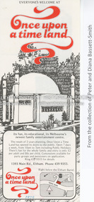 Eltham District Historical Society Inc
Document - Property Binder, 1393 Main Road, Eltham
Flyer, collected 1979, Once Upon a Time Land: pony rides, painting and sculpture, gnomezville, aquarium and reptile house (from collection of Peter and Diana Bassett-Smith).main road, eltham, businesses, once upon a time land