Showing 10531 items
matching land
-
 Bendigo Historical Society Inc.
Document - RESIDENCE AREAS REGISTER: SANDHURST VOLUME 6
Register: hard covered register, maroon material with dark buff spine and corners. Contains A-Z index in front section linked with registration details of residence areas in the Sandhurst district, Sandhurst division. Blue lined pages number 1 - 150 detailing land registrations. Dates from 1 December 1885 to August 1886.place, bendigo, residence areas, bendigo, sandhurst, land registrations, residence areas, land sales -
 Bendigo Historical Society Inc.
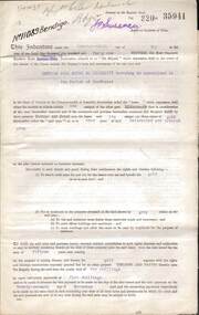
Document - MCCOLL, RANKIN AND STANISTREET COLLECTION: DEBORAH GOLD MINES NL GOLD MINING LEASE DOC, 1941
Document: McColl, Rankin and Stanistreet: Gold Mining Lease Private Land, 11089 Bendigo on front of document., Deborah Gold Mines NL - 3 pages, with map. Lease adjoins Railway Reserve, Breen Street. Transferred to North Deborah Mining Company NL on 9th. October, 1950. No. 11089, Vol 326 Fol 35941.organization, mining, gold mining lease, mccoll, rankin and stanistreet:, deborah gold mines nl, north deborah mining company nl, gold mining, lease -
 Bendigo Historical Society Inc.
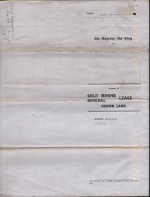
Document - MCCOLL, RANKIN AND STANISTREET COLLECTION: CENTRAL NAPOLEON GOLD MINING CO. N.L, 15th December 1934
Document: Gold Mining Lease Crown Land, No 10260 Bendigo, Entered in the register book vol. 307 fol. 34041, embossed seals of Central Napoleon Gold Mining Co N.L. & King George V, Map: No 10260, Mining district of Bendigo, Parish of Sandhurst, County of Bendigo, During the Reign of King George V.organization, business, industry - mining, mccoll rankin & stanistreet, mining, gold mining, central napoleon -
 National Vietnam Veterans Museum (NVVM)
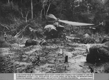
Photograph, Hastily Cut Clearing
A black and white photograph of a helicopter from 161 (Indep) Recce Flight hovers into a hastily cut clearing to land the Commanding Officer Lt Col David Butler, of 6 RAR/NZ (ANZAC) on the Nui May Tao Mountain during Operation Marsden. 6 RAR/NZ (ANZAC) had captured the Viet Cong K76A hospital.photograph, lt col butler, 6 rar/nz, 161 reconnaissance flight, operation marsden, nui may tao mountain, k76a hospital, gibbons collection catalogue -
 Whitehorse Historical Society Inc.
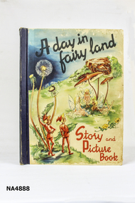
Document - Book, Before Xmas 1950
Book given to Barrie Cerdo-Pavia. husband of Elizabeth for Xmas in 1950 by his brother GrahamA large rectangular book. 'A day in Fairy Land'. Story and picture book. Dark blue spine with front cover with picture of fairies and pixies. Back cover is cream with pixies in centre. There are twenty pages in the book. Inside front cover is inscription 'to dear Barrie with best wishes for a very happy Christmas from Graham. Xmas 1950books, children's -
Whitehorse Historical Society Inc.
Article, Vermont South's salute, 1976
A 'City of Nunawading week' will be staged at Vermont South Shopping Centre. The week's activities will illustrate council sponsored activities.A 'City of Nunawading week' will be staged at Vermont South Shopping Centre. The week's activities will illustrate council sponsored activities. The shopping centre adjoins a large area of council owned land where a big new community centre is planned. the new primary school to be built in Livingstone Road and ready for occupation in 1978 will be planned to fit in with the development.A 'City of Nunawading week' will be staged at Vermont South Shopping Centre. The week's activities will illustrate council sponsored activities. shops, city of nunawading, vermont south shopping centre, livingstone primary school vermont south -
Whitehorse Historical Society Inc.
Certificate - Land Title, McCracken Orchards, 2000
Collection of Certificates of Title and lodged plans covering the land used as an orchard by the McCracken Family 1898 - 1962, comprising Cert. of Title vol 2699, Fol 660; Crown Portion 96, 1864 (part), Crown Portion 96, 1996; lodged plans 3681, 19126, 22255, 22256, 33386, with brief history prepared by P. Simmenauer.mccracken, john, mccracken, george, blackburn south, orchard grove, blackburn south, mccracken avenue, blackburn south, stewart avenue, blackburn south, lawrence street, blackburn south, wilton, edward, canterbury road, blackburn south, barns street, blackburn south, ralph street, blackburn south, horkings street, blackburn south, st ninians uniting church, blackburn south -
Whitehorse Historical Society Inc.
Document, Strathdon Community, 1982
A history of Strathdon Community, Caring for the aged, commenced on land donated by Mrs Mary Matheson.A history of Strathdon Community, Caring for the aged, commenced on land donated by Mrs Mary Matheson. Captain Matheson named the house originally on the estate 'Strathdon' in memory of the barque on which he served his apprenticeship. In 1968 the first section of the building opened. In 1977 Strathdon became part of the Uniting Church. In 1978 the nursing home was completed.A history of Strathdon Community, Caring for the aged, commenced on land donated by Mrs Mary Matheson. community services, strathdon community, miller, marjorie, matheson, mary, matheson estate, forest hill, uniting church, strathdon missionary group, strathdon foothills auxiliary, strathdon (ship) -
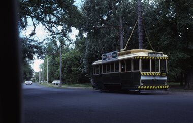 Ballarat Tramway Museum
Slide - 35mm slide/s - set of 3, Frank Londey, Apr. 1985
Set of three 35mm Kodachrome cardboard mount - colour slides by Frank Londey of operations at the BTPS depot and in Wendouree Parade January 1986 or could be 1985 (date on the slide) Perhaps during an organised tour .1 - 14 Northbound in Wendouree Parade approaching Fairy land. .2 - 27 at the depot with 671 behind .3 - 671 in the depot tramways, trams, btps, btm, depot, wendouree parade, tram 14, tram 671, tram 27 -
 Ballarat Tramway Museum
Photograph - Digital image, W. J. Llewelyn, late 1971
Colour digital image taken by W. J. Llewelyn of Donald Campbell's "Bluebird", Sturt St. when the convoy passed through Ballarat Bluebird was one the motor vehicle used in the land world speed record attempts of the era. Shows many people milling around the truck carrying the trailer, barricades. Photo outside the Town Hall.trams, tramways, sturt st, sports, bluebird -
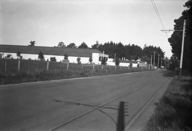 Ballarat Tramway Museum
Negative, Wal Jack, late 1930's
Yields information about Ballarat 's tram depot building from Wendouree Parade and a possible land sale.Negative and Digital image of the Wal Jack Ballarat Negative file of the depot as seen from Wendouree Parade from near the intersection with Forest St. Has a single trucker turning into the depot. There appears to be a sign on the land, possibly advertising it for sale. Shows the buildings after the new front has been put on. Late 1930's. trams, tramways, depot, wendouree parade, sale of land -
 Bendigo Historical Society Inc.
Document - RESEARCH PAPERS: EPSOM HJ JONES SHAMROCK HOTEL
A 14 page document detailing the history of William Davys Jone's family and businesses history regarding his ownership of multiple butchers and the Epsom Shamrock Hotel which was on the corner in front of 27 Howard St and was demolished in 1930, the land is now occupied by many large businesses like Woolworths and Aldi and is now being developed into many storefronts. -
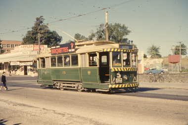 Ballarat Tramway Museum
Slide - 35mm slide/s, Wal Jack, 23/03/1962 12:00:00 AM
Ballarat Tram No. 26, in Barkly St, near Main St. - 23.3.1962. Tram has dash canopy lighting, but small white strip. Has large briquettes roof ad and White Horse scotch whiskey ad on front. In back is vacant block and land and corner store. Young lady walking across the road to catch the tram.'SEC Ballarat, No. 26 in Barkly St. near Main St., Ballarat East, 23/3/62' in blue ink.tramways, trams, ballarat, barkly st, tram 26 -
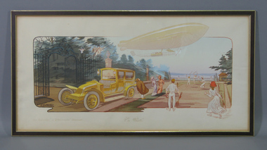 Tennis Australia
Poster, 1915
Reproduction of colour advertising poster for Renault company with title caption: 'EN VISITE'. Depicts a zeppelin about to land close to a tennis court on a terrace. A large motor car is parked nearby. Other text captions: 'LE "LEVRIER" ET "L'HIRONDELLE" RENAULT'. Materials: Ink, Paper, Cardboard, Wood, Glass, Metal, Adhesive labeltennis -
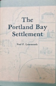 Port Fairy Historical Society Museum and Archives
Book, The Historical Committee Of Portland, The Portland Bay Settlement, 1934
Aboriginal resistance to settlement, Native Police Force, G.A. Robinsons proposal to re-settle Flinders Island people and extracts fom his 1841 expedition report. Contents I. The early navigators and explorers II. Sealers and whalers and tales of the sea III. The Hentys and Victoria's first permanent settlement IV. Early incidents and personalities V. Under government control Vi. Social life and activities VII. The story of the press VIII. Business, professions and industry IX. Hotels and roads X. Sport XI. Environs of Portland XII. Miscellaneous historical items.8vo; pp. x, 285; frontispiece, numerous b/w illustrations, plans and maps two of which are folding, index, appendices including "List of Purchasers at original land sale", "First Election List", "Subscription lists for both First Church of England and First Presbyterian Church", original blue cloth, title in gilt on spinenon-fictionAboriginal resistance to settlement, Native Police Force, G.A. Robinsons proposal to re-settle Flinders Island people and extracts fom his 1841 expedition report. Contents I. The early navigators and explorers II. Sealers and whalers and tales of the sea III. The Hentys and Victoria's first permanent settlement IV. Early incidents and personalities V. Under government control Vi. Social life and activities VII. The story of the press VIII. Business, professions and industry IX. Hotels and roads X. Sport XI. Environs of Portland XII. Miscellaneous historical items.robinson, george augustus, 1791-1866., government policy - initial period and protectionism - 1788-1850., government policy - state and territory - victoria., law enforcement - police - native police., race relations - violent - massacres, murders, poisonings etc. - to 1900., sport., pioneers -- victoria -- portland., portland (w vic sj54-11), portland (vic.) -- history., book -
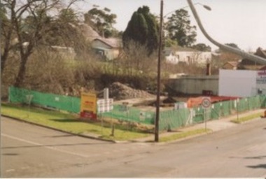 Kilmore Historical Society
Photograph, Mobil Garage, 2006
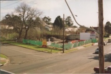
Previously Mobil Garage owned by Danny and Pat D'Elia until 2001. Then demolished in 2006.15cm x 10cm colour photograph of the corner of Lancefield Road and Sydney Street. Printed on matte photographic paper (Kodak brand) Recent demolished building with rubble piled up and green security fencing around the perimeter of the property. Sign for the Willowmavin Estate is visible advertising land sales. Multiple photographs with multiple views available.Printed on back: Development information: Premier -
 Kilmore Historical Society
Photograph, Mobil Garage, 2007
Previously Mobil Garage owned by Danny and Pat D'Elia until 2001. Then demolished in 2006.15cm x 10cm colour photograph of the corner of Lancefield Road and Sydney Street. Printed on matte photographic paper (Kodak brand) Recent demolished building with rubble piled up and green security fencing around the perimeter of the property. Sign for the Willowmavin Estate is visible advertising land sales. Multiple photographs with multiple views available.Printed on the back: Development information: PREMIER -
University of Melbourne, Burnley Campus Archives
Newspaper - Newspaper Cutting, The South Bourke Standard, The Horticultural Society, 1864
Cop[y of article in "The South Bourke Standard" 29 July, 1864 p3. Description of the Annual Meeting of the Society. The December flood had destroyed the fruit tree plantings. The Government had refused a request to grant them more suitable land to the north so part of the ornamental section had to be broken up and planted with fruit trees.the south bourke standard, floods, ornamental garden broken up, fruit trees, fruit trees destroyed, refusal of government funding, government funding -
 Greensborough Historical Society
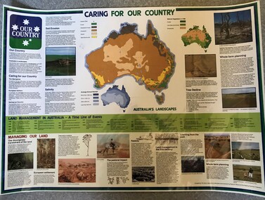
Poster, National Farmer's Federation et al, Caring for our Country, 1988c
A timeline of land management including indigenous care and the impact of European settlement from 1988 to 1987. Includes maps showing present land use and vegetation coverage in 1788. Prepared by Tim Gurry for the National Farmer’s FederationLaminated poster, printed in colour on one side.land management, farming, salinity -
 Whitehorse Historical Society Inc.
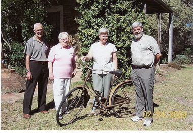
Photograph, Mrs Arthur Hooke's Bicycle
Mr & Mrs Arthur Hooke purchased land in Blackburn in 1914, which they called Wandinong. In 1972 after the death of Mr Hooke, the family donated a large part of the land to the then City of Nunawading to create the Wandinong Bush Park.Coloured photo of the bicycle used by Mrs Arthur Hooke of Blackburn being presented to Bob and Barbara Gardiner of the Whitehorse Historical Society by two of her grandchildren, Bill Ellemor and Christine Pinnegarellemor bill, pinniger, christine, hooke family, bicycles -
 The Beechworth Burke Museum Research Collection
Card (Series) - Index Card, George Tibbits, Ford Street, Beechworth, 1976
George Tibbits, University of Melbourne. Faculty of Architecture, Building and Town & Regional PlanningIndex system that support the research for Beechworth : historical reconstruction / [by] George Tibbits ... [et al]Arranged by street names of BeechworthEach index card includes: street name and number of property, image of property, allotment and section number, property owners and dates of ownership, description of the property according to rate records, property floor plan with dimensions.beechworth, george tibbitsbeechworth, george tibbits -
 Surrey Hills Historical Society Collection
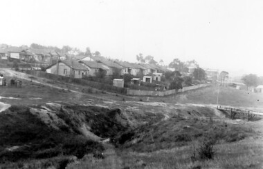
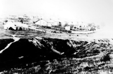
Photograph, Back Creek (later South Surrey Park), c 1936, 1936
This photo was taken at the opening of the footbridge by Sir Winston Dugan in 1936.South Surrey Park was developed on land which had been the property of the Kleinert family. Their land extended from Union Road to Essex Road. They ran horses, ducks and fowls and Emily Kleinert grew flowers. Alan Holt research: Lot 6 was sold to Martin Klienert by Karl Richter in 1860 together with a portion of another adjacent lot. From 1860-1885 Martin worked it as a market garden leasing some land for grazing when it was not required for gardening. He died in 1898. In a formal document, William declared he was the son of Martin "who purchased land in 1860, died in 1898 and the land has been continually occupied by father and family since. It has been cultivated as a market garden; when not being used for gardening it was let for cultivation and grazing." William died in 1939 and the property passed to his sons Martin and Ernest. The family sold the land to the Camberwell Council in the 1950s.This photo is significant as it shows the transition from rural to urban land use in Surrey Hills.Black and white photo taken in the area later known as South Surrey Park. Back Creek is in the foreground. There is a tent on the LHS and approximately 7 houses which front Verdun Street. Some of their backyards face onto the open space along the creek bed.parks and reserves, creeks, south surrey park, civic occasion, official events, back creek, verdun street, 1936, kleinert family, sir winston dugan, topography -
 Surrey Hills Historical Society Collection
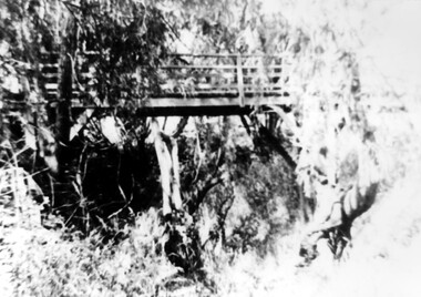
Photograph, Footbridge across Back Creek, 1980, 1980
South Surrey Park was developed on land which had been the property of the Kleinert family. Their land extended from Union Road to Essex Road. They ran horses, ducks and fowls and Emily Kleinert grew flowers. Alan Holt research: Lot 6 was sold to Martin Klienert by Karl Richter in 1860 together with a portion of another adjacent lot. From 1860-1885 Martin worked it as a market garden leasing some land for grazing when it was not required for gardening. He died in 1898. In a formal document, William declared he was the son of Martin "who purchased land in 1860, died in 1898 and the land has been continually occupied by father and family since. It has been cultivated as a market garden; when not being used for gardening it was let for cultivation and grazing." William died in 1939 and the property passed to his sons Martin and Ernest. The family sold the land to the Camberwell Council in the 1950s. The original footbridge was opened by Sir Winston Dugan in 1936.Black and white photo of a wooden footbridge with large trees and shrubs obscuring its surrounds.parks and reserves, creeks, south surrey park, back creek, verdun street, footbridges -
 Greensborough Historical Society
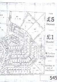
Advertisement, Greenhills Estate, 1923c
The advertisement was used to sell land in the Greenhills area.The plan included details the original street lay out and names applied to them. It also has dimensions of all the blocks of land available and locations and dimensions of easements.A 2 page A3 photoccopy of a real estate advertisement. Nilgreehills, subdivision plan, greensborough -
 Greensborough Historical Society
Photograph - Digital image, Frank Solomon, House among the trees, Greensborough, 1990c
A patch of open land in Greensborough circa 1990Digital copy of colour photographbriar hill, greensborough -
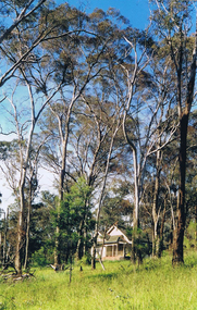
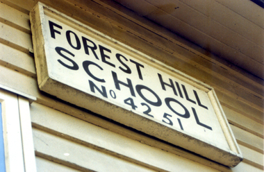
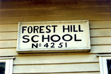 Whitehorse Historical Society Inc.
Photograph, Forest Hill State School, 1/08/1993 12:00:00 AM
School closed , demolished and land sold for housing .Coloured Photo of Forest Hill State School No. 4251.Springvale Road, Forest Hill. Since demolished. Part of a group of 24.forest hill state school. no. 4251 -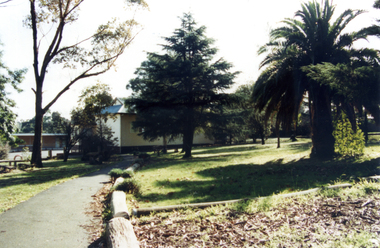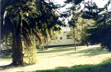
 Whitehorse Historical Society Inc.
Photograph, Forest Hill State School, 1/08/1993 12:00:00 AM
School closed , demolished and land sold for housing .Coloured Photo of Forest Hill State School No. 4251.Springvale Road, Forest Hill. Since demolished. Part of a group of 24.forest hill state school.no. 4251