Showing 6699 items
matching river
-
 Greensborough Historical Society
Article - Newspaper Clipping (copy), Jas Blackburn, The locality of Batman's Treaty with the Port Phillip natives, 09/01/1886
Text of a paper read before the Historical Society of Australia by Jas. Blackburn in 1886. Discusses Batman's Treaty with the Port Phillip traditional owners and the possible site of the signing - on the east side of the River Plenty, NW of Eltham andd 3 miles above the junction of the Plenty with the Yarra River.6p. text.john batman, batman's treaty, port phillip district, plenty river -
 Orbost & District Historical Society
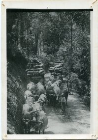
black and white photograph, late 19th - early 20th century
This is a photograph of bullock teams on the Cann Road. out of Cann River, East Gippsland.This is a pictorial record of transport in the mid 18th - early 19th century. Bullock teams could travel in country inaccessible to larger horse - drawn carts or wagon.A black / white photograph of two bullock teams travelling side by side along a bush road.transport-bullocks cann-river -
 Marysville & District Historical Society
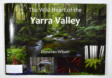
Book, The Wild Heart of the Yarra Valley
A pictorial book of the flora, fauna, rivers, waterfalls and rainforest in the Upper Yarra ValleyPaperback. Front cover has a main photograph of a creek running through a forest. There is also four smaller photographs. They are of a Red Coral Fungi, a Superb Lyrebird, a night time view looking upwards in a grove of trees and a view of a Soft tree fern. The back cover has a photograph of a Superb Lyrebird.yarra valley, upper yarra valley, flora, fauna, photography, rivers, waterfalls, rainforest, nature, donovan wilson -
 Marysville & District Historical Society
Book, The Wild Heart of the Yarra Valley
A pictorial book of the flora, fauna, rivers, waterfalls and rainforest in the Upper Yarra ValleyPaperback. Front cover has a main photograph of a creek running through a forest. There is also four smaller photographs. They are of a Red Coral Fungi, a Superb Lyrebird, a night time view looking upwards in a grove of trees and a view of a Soft tree fern. The back cover has a photograph of a Superb Lyrebird.yarra valley, upper yarra valley, flora, fauna, photography, rivers, waterfalls, rainforest, nature, donovan wilson -
 Greensborough Historical Society
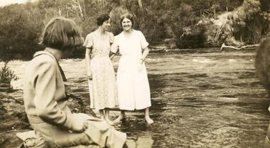
Photograph - Digital image, Myrtle McLaughlin and friends 1935, 1935_
Photograph of Myrtle McLaughlin, Ethyl Bradbury and Dorothy Curtis in 1935. Taken by the river.. The collection contains photographs of friends and relatives from the Greensborough and Eltham areas.Digital copy of black and white photograph.myrtle mclaughlin, ethyl bradbury, dorothy curtis -
 Greensborough Historical Society
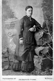
Photograph - Digital Image, Mary Mitchell, 1882c
Mary Mitchell and the Mitchell family lived in Hailes Street on a property that went to the river.Digital copy of black and white studio photograph.mary mithcell, mitchell family -
 Tatura Irrigation & Wartime Camps Museum
Water Wheel Accuracy Tester, Late 1900s
Used by State Rivers and Water Supply Commission prior to their privatisation about 1990.A clear tube with sand inside - similar to an egg timer. Used to measure the accuracy of water wheels over a half minute or less. Measurements marked on outside and related to one revolution. The blue scales relate to small meter outlets(wheels), yellow scales related to large meter outlets(wheels).Figures of rates relating to measurement of water in one revolution.irrigation, victoria state rivers and water supply commission, water wheel -
 Ballarat Heritage Services
Photograph, Views of the Westgate Bridge, 29/11/2022
The Westgate Bridge spans the Yarra River giving access to Melbourne from the West. westgate bridge, melbourne, road, bridge -
 Charlton Golden Grains Museum Inc
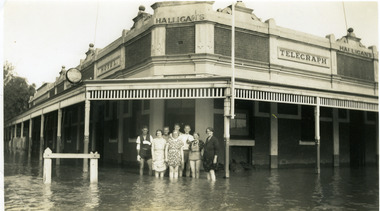
Photograph - Telegraph Hotel in 1939 flood, 1939
Telegraph Hotel in 1939 flood. The river level reached 8.25 metres in April.Black & white photograph of Halligan's Telegraph Hotel in 1939 flood. Corner of Armstrong & Camp Streets. Halligans & staff including Tess Maher (Loughnan) standing in front of hotelAvoca Rover flood Easter 1939. Donated by Mrs T Loughnan.flood, hotels, halligan, telegraph hotel, business, armstrong street, charlton -
 The Beechworth Burke Museum
Photograph - Lantern Slide, c1900
This image shows a view of a properties bordering a river in the vicinity of Beechworth in approximately 1900. Although the exact location of the photograph is yet to be determined, the water source pictured may feed into the bigger system that flows through Beechworth Gorge. A man wearing a hat, possibly the photographer, is silhouetted in the foreground of the picture. Lantern slides, sometimes called 'magic lantern' slides, are glass plates on which an image has been secured for the purpose of projection. Glass slides were etched or hand-painted for this purpose from the Eighteenth Century but the process became more popular and accessible to the public with the development of photographic-emulsion slides used with a 'Magic Lantern' device in the mid-Nineteenth Century. Photographic lantern slides comprise a double-negative emulsion layer (forming a positive image) between thin glass plates that are bound together. A number of processes existed to form and bind the emulsion layer to the base plate, including the albumen, wet plate collodion, gelatine dry plate and woodburytype techniques. Lantern slides and magic lantern technologies are seen as foundational precursors to the development of modern photography and film-making techniques.This glass slide is significant because it provides insight into Beechworth's built environment and natural landscape in the early Twentieth Century, around the time of Australia's Federation. It is also an example of an early photographic and film-making technology in use in regional Victoria in the time period.Thin translucent sheet of glass with a square image printed on the front and framed in a black backing. It is held together by metals strips to secure the edges of the slide.burke museum, beechworth, lantern slide, slide, glass slide, plate, burke museum collection, photograph, monochrome, photographer, beechworth gorge, river, stream, water source, 1900s -
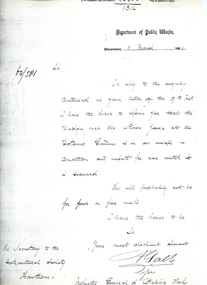 University of Melbourne, Burnley Campus Archives
Letter, Department of Public Works, 11/3/1864
Letter re unsafe state of bridge over Yarra River This is a photocopy of the original letter which was written by A. Gable (?) on behalf of the Inspector General of Public Works. It comments on the unsafe state of the bridge over the Yarra River by the Botanic Gardens. Provided by Diane Nicholas Librarian at Hawthorn Library 1994Letter from Department of Public Works to Secretary of Horticultural Societybridge, yarra river, unsafe bridge, bridge safety melbourne, bridge safety 1800s, a. gable, inspector general of public works -
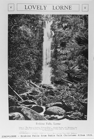 Lorne Historical Society
Pamphlet - Tourist Brochure, Lovely Lorne
The Victorian Railways promoted tourist destinations around Victoria. A folded paper tourist brochure about Lorne The front cover is a coloured painting of Lorne from above the Erskine River towards the main beach. , on the back is a black and white sketch tourist map of the roads, tracks and beauty spots. Inside the first fold are 6 black and white photographs, Cumberland River, Mt St George, Phantom Falls, Cumberland Cliffs, Teddy’s Lookout, leafy walk towards the pier. Inside contains written descriptions of the highlights of Lorne and six black and white photographs, four general views of Lorne, Lover’s Walk, Erskine Falls . souvenirs, victorian railways, publicity -
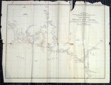 Federation University Historical Collection
Map, British New Guinea, 1893, 1893
The map was surveyed by ship compass, distances by estimation or rate of launch by officers of the Government ; supervised and compiled by J.B. Cameron, G.S. March 1893. This map was in the possession of Charles Carty Salmon (1860-1917), politician, born on 27 July 1860 at Amherst, Victoria. (http://adb.anu.edu.au/biography/salmon-charles-carty-8328 ) Although living in Melbourne Charles Carty Salmon kept property at Talbot. The property was leased, then purchased by the donor's family. A copy of "The Goulburn Weir and its Dependent System of Works" and this map (in a government envelope addressed to Salmon) were left at the property. See http://nla.gov.au/nla.map-rm1894-1 .1) Sketch map showing the rivers and an outline of the coast from Long. 144?30'E. to Long. 146?30'E. Gulf of Papua British New Guinea Scale [ca. 1:316,800]. .2) Large envelope addressed to The Hon Charles Carty Salmon M.P., Talbot, Victoria. The map was folded and stored in this envelope. Map extending from Port Bevan to Kaikavau Pt, showing rivers and notes on soil and vegetation. Relief shown by hachures and spot heights. Also available in an electronic version via the Internet at: http://nla.gov.au/nla.map-rm1894-1 .1) "Enclosure in Despatch No. 32 of 3rd May 1893 - Appendix G.". "Map no. 4 British New Guinea report 1892-93". .2) "This envelope can only be lawfully used by Government Officials on public business. Any use by Officials on private business, or by others under any circumstances, is punishable." "Commonwealth Celebrations. General Secretary's Office, Melbourne."carty salmon, charles carty salmon, new guinea, j.b. cameron -
 Kew Historical Society Inc
Photograph - Zig-Zag Bridge, 1924
Henry Beater Christian (1886-1962) , was a descendant of one of the earliest settler families in Kew. Employed at the Kew Asylum as a 'public servant', he was a skilled amateur photographer, photographing numerous scenes in Kew and on his travels around Victoria. The majority of his photographs date from 1916 to 1929. His finest photographs are housed in two photograph albums. Digital copy of a photograph from page 8 of the 47-page photograph album containing 261 gelatinous silver images, loaned by Diane Washfold with permission given to digitise and hold a copy in our collection. The Zig-Zag Bridge linked the grounds of the Yarra Bend and Kew Asylums. The wooden bridge was constructed in the 1870s and lasted through numerous floods until its destruction in 1929. A horizontal structure, the walkway was reached via a wooden staircase. The steps were requires due to the different levels of the banks on this stretch of the river. The photo is taken from the Kew side of the river. "Zig-Zag Bridge"henry beater christian (1886-1962), landscape photography, kew (vic.) — yarra river, christian-washfold collection, photograph albums, zig-zag bridge -
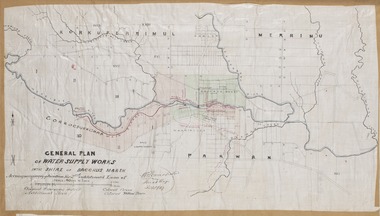 Bacchus Marsh & District Historical Society
Map, General Plan for Water Supply Works, Shire of Bacchus Marsh 1887
Debate about water supply and its planning and development took place in the Bacchus Marsh region from the 1850s through into the twentieth century. This plan was part of documentation to support an application for an additional loan of money from the Ministry of Water Supply to the Bacchus Marsh Shire Water Supply Trust. The plan includes the route of a proposed water channel in the Parwan area, and other features of water supply infrastructure such as the location of standpipes and gates are also shown on the plan.A single page paper map showing a general plan for the supply of water in the Bacchus Marsh area.The plan shows the route of the 'Main Channel' near the Werribee River and a proposed route for a Parwan Channel. The location of 'Dryden's House' near the Werribee River is also shown and the locations of land held by T. (Tom) Oliver and the Racecourse Reserve in Maddingley. Scale 40 chains to 1 inch. The plan is signed by Bacchus Marsh Shire Engineer, W.E. Standfield. The map is pasted into a bound volume containing 76 maps or plans in total. High resolution digital image stored on BMDHS computer network. General Plan of Water Supply Works in the Shire of Bacchus Marsh. Accompanying application for 2nd additional Loan. Original Waterworks district. Additional area. W.E. Standfield, 30/8/87.water supply, water supply maps, water supply bacchus marsh, irrigation, bacchus marsh victoria maps -
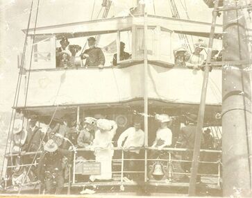 Port Fairy Historical Society Museum and Archives
Photograph
S.s.Casino 1910. The people on the decks are tourists coming from Terang and surrounding areas to spend the day at the seaside. The steamer S.S.CASINO was much loved by the whole Port Fairy community- with the possible exception of some of the fishermen whose boats she ran down! Transport of the large quantities of wool, potatoes, onions, grain, sheep, cattle and other produce grown on the rich lands of the Western District Belfast was served by a plethora of shipping, both sail and steam, but only one of the steamers then in the regular trade (S.S. DAWN) would ever be able to get up the river and reap the cost savings of loading against a wharf. It was not unusual for four steamers to be anchored in the bay at once and for seven or eight different steamers to call during a week. A number of inter-colonial steamers also called to pick up produce for delivery to Melbourne, Sydney and Adelaide. Production in the Western District was increasing and virtually all of that production had to go through one of the western ports in order to reach markets. By 1882 a meeting 15ft. March, 1882, in the office of auctioneer, J.B. HoIden in Cox Street took action and it was unanimously resolved - that the Belfast & Koroit Steamship Company be formed with a capital of £20,000 in 10,000 shares of £2 each". A number of steamers were offered by letter to the fledgling company, including the new and almost sister ships, CASINO and HELEN NICHOLL. The CASINO was on her delivery voyage from England was due to arrive in Warrnambool to load potatoes for Sydney and, initially, arrangements were made for her to call into Port Fairy for inspection by the BKNS Co directors. She eventually proceeded direct to Warrnambool and the Directors inspected her there. Without hesitation they purchased her even though they had to raise a large bank loan to do so. The CASINO arrived in Port Fairy on Saturday, 29th. July, 1882, steaming triumphantly up the Moyne River, and was greeted by crowds, many of whom had driven in from the surrounding countryside, which gave her “loud ringing English cheers". By 1884 the CASINO could not carry all the cargoes available to her and in December of that year the company purchased the new steamer BELLINGER to provide additional capacity. She helped to open up the intermediate ports of Lorne, Apollo Bay and Port Campbell, but the BELLINGER was not really suitable for the trade and she was sold in 1887, leaving the CASINO to operate alone -as she was to do for almost all of the next 45 years. The opening of the railway in 1890 decreased the cargo available to the steamers and the economic depression of the early 1890's worsened the situation. The weak soon began to fall by the wayside and when the Portland & Belfast SN Co. decided to go into liquidation in April 1895, the Belfast & Koroit Company bought the Portland Company's steamer DAWN on advantageous terms, a substantial part of the payment being in BKSN Co shares. The BKNS Co and the Howard Smith Line came into direct head to head competition and nearly forced the BKNS Co out of existence. Cargo dropped to such an extent that in 1899, they reached agreement that only one ship would run and that the ship which ran would pay a weekly amount to the competitor to stay out of the trade. This controlled service ceased in1909, and competition intensified when Howard Smith placed the newly built, larger steamer EUMERALLA on the run. The BKNS Co survived this competition and even prospered during it partly by extending on a more regular basis, the CASINO'S voyages to South Australian ports Port Macdonnell, Kingston, Beachport, Robe and, on occasions Adelaide. There were setbacks when, on 20 October 1924, CASINO went ashore at the Kennett River, near Apollo Bay, and again, in February l929, when she struck a submerged object at Warrnambool and had to be beached. The railways placed great competitive pressure on the small steamship company and this pressure was intensified when the Great Depression slashed the market for Western District produce, BKNS Co struggled on, paying dividends in most years, and the company planned a big celebration for the CASINO'S fiftieth anniversary in the trade on 29th July, 1932. Disaster struck soon after 9 o'clock on the morning of Sunday I0 July, 1932 when the CASINO was lost at Apollo Bay together with the lives of 10 crew members. Black and white photograph of tourists crowded on the decks of s.s.Casino during a sail around the bay for Terang dayship, boat, sea, river, s.s.casino 1910, transport, 1910, wool, onions, grain, sheep, cattle, steam, terang day -
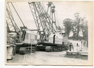 Orbost & District Historical Society
black and white photographs, 1974 - 1976
Construction of the roadway embankment between the bridges across the Snowy River flood plains at Orbost commenced in January 1974 and was completed in November 1976. Pearsons were the bridge contractors for the construction of the Princes Freeway and bridges across the river flood plains at Orbost. Heavy rains and floods held up progress.These photographs are of the construction of a major structure in Orbost. The opening of this Snowy River Bridge was an important development in the accessibility to the township of Orbost.Four black / white photographs of construction sites. 3241.1 is of three cranes and other machinery with six persons. 3241.2 is of workmen working on flooded site. 3241.3 is a photograph of the early stages of construction of a bridge looking towards the township. 3241.4 shows the construction of a roadway between the bridges.construction-snowy-river-bridge bridge-orbost -
 Orbost & District Historical Society
book, Historic Photos, c 1986
This book was compiled by volunteers at the Orbost Visitor Information Centre(Slab Hut) as a reference for visitors.This item is a useful reference tool.A white plastic-covered 2 ring binder with title Historic Photos inside cover. It contains photos of past and present residents , businesses, streets, transport, scenery, bridges and nearby places. It also contains a newspaper - Snowy River Holiday News (1986).orbost-history slab-hut -
 Orbost & District Historical Society
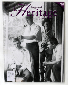
journal, Gippsland Heritage Journal, 2004
This issue edited by Meredith Fletcher.This item is a useful reference for the history of Gippsland.A 64 pp magazine, plastic covered, titled Gippsland Heritage Journal. The front cover is purple with a b/w photograph of the Hamilton Brothers on the verandah of Ensay Station. The magazine contains photographs, articles on the history of Gippsland. It includes a story on "The Snowy River Bandit".On back is a library barcode and a price sticker-$13.20. On the front cover is a call no. 996.65 GIPmagazine-gippsland-heritage-journal history-gippsland snowy-river-bandit -
 Kiewa Valley Historical Society
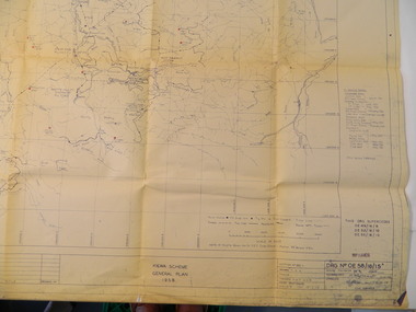
Plan - Kiewa Scheme General Plan 1958, S.E.C.V. Design & Construction Dept. Civil Branch, Dec. 1958
The Kiewa Hydro Electric Scheme was constructed by the State Electricity Commission of Victoria. Draftsmen drew up the plan of the layout as per the instructions from the engineers. The plan was drawn up on a transparency sheet and paper prints run off on a 'dyeline' copier. The 'Chief draftsman' and 'Design engineer' and 'Civil engineers recommended it and approved it. Historic: This plan gives a time line for the work on the Kiewa Hydro Electric Scheme. It is a good example of the work of a draftsman and the copying process in 1958.Large topography map of the area covered by the Kiewa Hydro Electric Scheme in 1958. Mountain peaks are marked in red and named. Rivers, roads, construction infrastructure as well as the main areas / names of construction are named. Signed and dated by employees of the S.E.C.V. working on the scheme.state electricity commission of victoria., kiewa hydro electric scheme, plan, engineer, draftsman -
 Marysville & District Historical Society
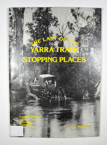
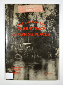
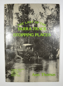
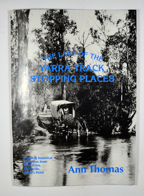
Book, The Last of the Yarra Track Stopping Places, 1980
A history of the stopping points on the Yarra TrackPaperback. Front cover has a black and white photograph of a wagon being pulled by two horses which have stopped to drink from a wide river. The back cover has a black and white photograph of an area of snow with a snow covered bush in the foreground.Inside back cover / From Kim Harley / Cliffton Hill Stamp of Marysville & District / Historical Society Inc / P.O. Box 22 / Marysville 3779marysville, yarra glen, wood's point, history, yarra track -
 Marysville & District Historical Society
Book, The Last of the Yarra Track Stopping Places, 1980
A history of the stopping points on the Yarra TrackPaperback. Front cover has a black and white photograph of a wagon being pulled by two horses which have stopped to drink from a wide river. The back cover has a black and white photograph of an area of snow with a snow covered bush in the foreground.Sticker on front cover / Revised / Edition Stamp of Marysville & District / Historical Society Inc / P.O. Box 22 / Marysville 3779marysville, yarra glen, wood's point, history, yarra track -
 Marysville & District Historical Society
Book, The Last of the Yarra Track Stopping Places, 1980
A history of the stopping points on the Yarra TrackPaperback. Front cover has a black and white photograph of a wagon being pulled by two horses which have stopped to drink from a wide river. The back cover has a black and white photograph of an area of snow with a snow covered bush in the foreground.With Best Wishes / Ann Thomas / 24.10.95 Stamp of Marysville & District / Historical Society Inc / P.O. Box 22 / Marysville 3779marysville, yarra glen, wood's point, history, yarra track -
 Marysville & District Historical Society
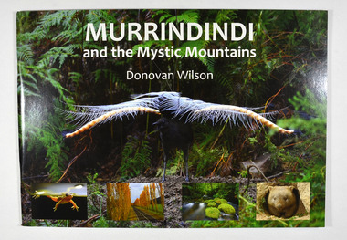
Book, Donovan Wilson, Murrindindi and the Mystic Mountains, Post 2009
A book of photographs of natural attractions, flora and fauna taken in and around the Murrindindi Shire.Paperback. Front cover has a large photograph of a lyrebird in full song. Along the lower edge of the front cover are four photographs; a Spotted March frog, the Gould Memorial Drive, a river and a wombat. Back cover has a photograph of the Cathedral Range at dawn.non-fictionA book of photographs of natural attractions, flora and fauna taken in and around the Murrindindi Shire.murrindindi, victoria, landmarks, flora, fauna, waterfalls, rivers, nature, natural attractions -
 Bendigo Military Museum
Postcard - POSTCARD, PHOTOGRAPHIC, WW1, League of Soldiers Friends, Victoria
1. This card was printed by the "League of soldiers friends - C of E Organisation in Victoria. To help the A.I.F." It has been stamped by the AIF camp PO 19 April 19. 2. Nothing specific.1. Black and white view of ships in a harbour. In the foreground are some tree tops. A big city is in the background. This card has a pre-printed message from Southhampton. 2, Boats in a river/canal. Black and white photo. The water way is in a deep valley.1. Addressed to Miss S. Stuart, Serpentine via Inglewood, Vic, Australia. It is signed by J. Stuart. 18 April 1919. 2. Addressed to Dear Susie, 10 lines text - signed your loving brother Joe.postcards, ww1 -
Glenelg Shire Council Cultural Collection
Print - Contact Print - Wattle Creek Pastoral Scene, 1960-1979
Sheet of 2 black and white contact prints from glass plate negatives. Top: River/Creek ? Wattle Creek running thru reeds and bushland. Bottom: Bridge across Wattle Creek from beach. Botanic Gardens on right, Kingsley in background. -
 Orbost & District Historical Society
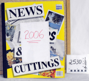
scrap books, 2006 ; 2007
These four scrap books were compiled by Margaret Smith, a long time member of the Orbost & District Historical Society. They were donated by her family after her death in 2015.These items are useful reference tools.Four large scrap books containing clippings from the Snowy River Mail. They are pasted in. Two books, 2529.1 and 2529.2 are for 2007 and 25209.3 and 2529.4 are for 2007. All books are large format books for NEWS & CUTTINGS. they contain personal items and news articles.Labelled 2006 and 2007smith-margaret news-orbost scrap-books -
 Marysville & District Historical Society
Book, The Last of the Yarra Track Stopping Places, 1980
A history of the stopping points on the Yarra TrackPaperback. Front cover has a black and white photograph of a wagon being pulled by two horses which have stopped to drink from a wide river. The back cover has a black and white photograph of an area of snow with a snow covered bush in the foreground.Sticker on front cover / Revised / Edition Stamp of Marysville & District / Historical Society Inc / P.O. Box 22 / Marysville 3779marysville, yarra glen, wood's point, history, yarra track -
 Marysville & District Historical Society
Book, Donovan Wilson, Murrindindi and the Mystic Mountains, Post 2009
A book of photographs of natural attractions, flora and fauna taken in and around the Murrindindi Shire.Paperback. Front cover has a large photograph of a lyrebird in full song. Along the lower edge of the front cover are four photographs; a Spotted March frog, the Gould Memorial Drive, a river and a wombat. Back cover has a photograph of the Cathedral Range at dawn.non-fictionA book of photographs of natural attractions, flora and fauna taken in and around the Murrindindi Shire.murrindindi, victoria, landmarks, flora, fauna, waterfalls, rivers, nature, natural attractions -
 Bendigo Historical Society Inc.
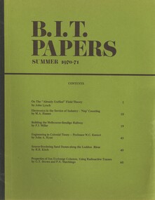
Book - BIT PAPERS, 1971
B.I.T. Papers Summer 1970-71, articles by various contributors, contents include, Building the Melbourne-Bendigo Railway, Engineering in Colonial Times, Source-Bordering Sand Dunes along the Loddon River & others, 66 pages with black and white photographs and maps..history, australian