Showing 3609 items
matching street map
-
 Ballarat Tramway Museum
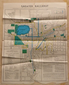
Map, Greater Ballarat Association and George Netherway, "Map of Ballarat", c1950
... Four colour map of Ballarat, showing streets, places... Greater Ballarat, including trams, buses, locations and streets ...Yields information about Greater Ballarat, including trams, buses, locations and streets. Has a strong association with George Netherway.Four colour map of Ballarat, showing streets, places of interest, Parks, tram routes, bus routes, railway lines, prepared by G. C. Netherway, Greater Ballarat Association. Shows suburbs names, location of places of interest, some development north of Howitt St, in Wendouree. Map is part diagrammatic and is not entirely to scale. Includes the Lake Wendouree Rowing course On rear is a road map of the Ballarat area, lists of statistics, beauty spots, look outs, art and culture, points of historical interest, industrial products and recreation. Printed by Waller & Chester on paper produced by Ballarat Paper Mills Pty Ltd. See Reg item 2074 for photographic image of this version of the map. See Reg Item 2776 for another version of this map. Contained originally within Reg Item 5507 at the back of the binder. For items see btm5507 loose items list.pdf John Whiting in an email of 17-9-2021 noted: The rowing course along Lake Wendouree is noted, so perhaps this map is post 1956? The Mt Pleasant tram line is shown to terminate at Morton St, not Cobden St (which of course is incorrect) Someone's come along and drawn in black ink the branch of the View Point tram line!trams, tramways, ballarat, tram routes, bus routes, map, lists -
 Ballarat Tramway Museum
Document - Personal Papers, Wal Jack, 1945
Handwritten notes on the Footscray tram system of the MMTB, April 1945, noting the depot layout, the routes, special services to the Munitions factories, track layouts in various street, cars based at Footscray, cars used on 20/4/1945 to the Munitions, notes on the cars and types, fares and route map along Ballarat Road. Contained originally within Reg Item 5623 at the front of this note book. For items see btm5623 loose items list.pdf.trams, tramways, footscray, mmtb -
 Ballarat Tramway Museum
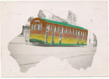
Photograph - Digital image, L.W. Torr Best Street Bowen Hill and Brisbane Q, 4/03/1939 12:00:00 AM
Yields information about Ballarat tram 29 when it was dressed for the Floral Festival and the launch of the tram and how it was used by a small photograph publisher for sales.Digital image from the Wal Jack Ballarat Album of a postcard featuring the 1939 Floral Tram, photograph at the depot, rendered in colour and positioned within an outline of a map of Australia. Wal's notes date it as 4-3-1939. Uses the same base photo similar to 1369, but without the motor bike in the rear. On the rear has a the stamp "L.W. Torr Best Street Bowen Hill, Brisbane Q" See image i2 for rear of photograph. See Reg Item 7000 for a hand coloured image.Stamped on the rear of the photograph "L.W. Torr Best Street Bowen Hills, Brisbane Q" and the date stamp "5 May 1939"trams, tramways, floral tram, decorated trams, depot, tram 29 -
 Queenscliffe Maritime Museum
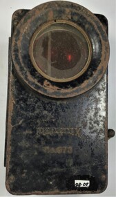
Equipment - Signal Light Box / flashlight
Flashlights where a vital tool for night time map reading, signaling with coloured lenses and many other uses. The blackout during the war also meant for a extended popularity of flashlights. Many carried them onto the streets to see as the streetlights where very rare and to top that of mostly blacked out. Most flashlights where fitted with blinds or coloured lenses to hide the bright light they produced. These coloured lenses where also used to signal between individual soldiers. Mostly used in the 1940s by the military and civilians alike. A small metal light signal box or flashlight.Petrix No. 678signal box, flashlight, petrix 678 -
 Otway Districts Historical Society
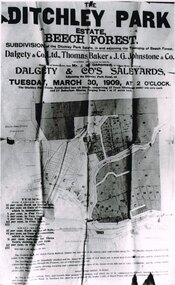
Photograph, Knox Collection, Sale of the Ditchley Park Estate, Beech Forest, 1908
Commercial realities and bushfires caused the Beech Forest community to re-establish itself around the railway station, away from Gardner Hill. This caused John W. Gardner to subdivide his land on the north side of the railway station. One subdivision was created near the Ditchley railway station on the old racecourse site, and another of 25 allotments forming what became Southorn Street. There were very few takers for these lots nor any buyers for the Ditchley subdivision.Photocopy. 260mm x 159mm. An advertisement for the sale of the Ditchley Park Estate, Beech Forest. Under instructions from Mr. J.W. Gardner Dalgety & Co. Ltd. will sell the subdivision of the Ditchley Park Estate on Tuesday, March 30, 1909, at 2 o'clock. A map of Beech Forest township and the Ditchley Park Estate is attached, as are the terms of sale and a description of the area.. beech forest; ditchley park; land sale; advertisment; -
 Colac RSL Sub Branch
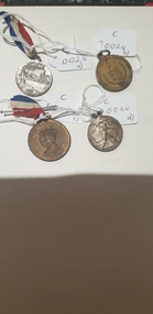
Medal - Medals x 4, a) Centenary of Melbourne medal. b) Borough & Shire of Colac. 1945 Peace & Victory Medal. c) Coronation Medal 1937. d) Victory Medal 1945, NK
Commemorative medallionsmediumRound commemorative medals x 4. a) Silver coloured medal with a with Red, white and blue ribbon. b) Bronze coloured medal. No ribbon c) Bronze " " with a red, white and blue ribbon d) Silver " " . No ribbon a) Front:- Centenary of Melbourne. 1932. Man looking at city skyline. 1835. Back:- Centenary of Victoria. 1934. Sailing ship/shoreline. 1834 b) Front:- Borough & Shire of Colac. Coat of Arms surrounded by wreath and crossed swords. Back:- Peace and Victory. Surrounded by a wreath c) Front:- King George VI & Queen Elizabeth. Portraits of King and Queen Back:- To Commemorate their Majesties' Coronation d) Front:- Man with a sword on a map of Australia. 1945 Back:- Map -
 Colac RSL Sub Branch
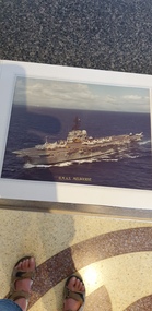
Photograph - Photograph of HMAS Melbourne in a presentation folder, Presentation folder
Photograph of the Australian Aircraft Carrier HMAS MelbourneHigh. Australia does not have an aircraft carrierGray coloured presentation folder with a photo of HMAS Melbourne and map inside Coloured photo of HMAS Melbourne -
 Bendigo Historical Society Inc.
Slide - DIGGERS & MINING. THE CHINESE ON THE GOLD FIELDS, c1850s
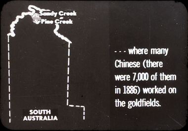
Diggers & Mining. The Chinese on the Gold Fields. Slide: Shows map of South Australia, Sandy Creek and Pine Creek are at the top of the map. Slide; reads . . . Where many Chinese (there were 7,000 of them in 1886) worked on the goldfields. Markings: 3. Used as a teaching aid.hanimounteducation, tertiary, goldfields -
 Bendigo Historical Society Inc.
Slide - DIGGERS & MINING. THE CHINESE ON THE GOLD FIELDS, c1850s
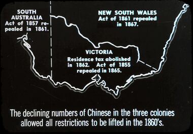
Diggers & Mining. The Chinese on the Gold Fields. Slide: Shows map of Victoria and part of South Australia and New South Wales. South Australia Act. Of 1857 repealed I 1861. New South Wales Act. Of 1861 repealed I 1867. Victoria Residence tax abolished in 1862. Act. Of 1855 repealed in 1865. The declining numbers of Chinese in the three colonies allowed all restrictions to be lifted in the 1860's. Markings: 2 2. Used as a teaching aid.hanimounteducation, tertiary, goldfields -
 Bendigo Historical Society Inc.
Map - OLD TOM MINE, WHIPSTICK
2 copies ( A4 and A3) of Old Tom lease. Map shows Old Tom Reef, old working open cutting, shaft 150 ft., Easter Reef, dam sand heap, water race, 3 other shafts, 120ft., 90ft., and 500 ft. marked on map. Stamped on map '64.3.34' Written on bottom of map in handwriting ' Old Tom Lease, Parish of Huntly, County of Bendigo, Mining district of Sandhurst'bendigo, mining, old tom lease map -
 Bendigo Historical Society Inc.
Document - MCCOLL, RANKIN AND STANISTREET COLLECTION: SITE LEASE, 3rd October, 1950
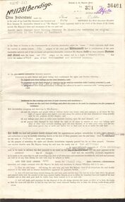
Mining site lease No. 11281. The lease of the site is for Machinery for the South Nell Gwynne Gold Mining Co., includes Map of the site. Dated 2nd September 1950.gold, mining, lease, bendigo, gold mines, mining lease, south nerll gwynne gold mining co. -
 Bendigo Historical Society Inc.
Document - MCCOLL, RANKIN AND STANISTREET COLLECTION: THANET LEASE, 1930's
Manilla folder of documents relating to the application by Herbert Jackson Leed for mining lease No. 10500, called the Thanet Lease. Containing a list of all of the owners of the allotments on the proposed lease and consent forms for them to sign. A map of the lease and of the subdivision of allotments 97 and 92. Various correspondence and application forms.gold, mining, land application, bendigo, gold mining. thanet lease, herbert jackson leed. -
 Bendigo Historical Society Inc.
Slide - DIGGERS & MINING. DIGGERS AND MINERS, c1850s
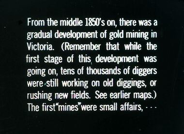
Diggers & Mining. Diggers and miners. From the middle 1850's on, there was a gradual development of gold mining in Victoria. (Remember that while the first stage of this, development was going on, tens of thousands of diggers were still working on old diggings, or rushing new fields. See earlier maps.) The first ''mines'' were small affairs, - - - Markings: 25 994:LIF I. Used as a teaching aid.hanimounteducation, tertiary, goldfields -
 Bendigo Historical Society Inc.
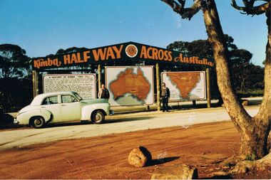
Photograph - PETER ELLIS COLLECTION: PETER ELLIS AND JOHN MEREDITH
Colour photo of Peter Ellis and John Meredith standing in front of the sign at Kimba Half Way Across Australia. There are three signs, one has the History of Kimba, one is a map of Australia and the other is a map with Spencer Gulf printed on it. A green Holden car is parked in front of the History sign.photo, group, male, peter ellis collection, peter ellis, john meredith -
 Bendigo Historical Society Inc.
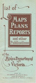
Document - LIST OF MAPS, PLANS, REPORTS PUBLISHED BY MINES DEPARTMENT VICTORIA 1938
Blue booklet, on front ' List of Maps, Plans, Reports and other publications of the Mines Department of Victoria. Issued by Geo Brown Secretary for Mines under the authority of The Hon. E.J. Hogan, MLA, Minister of Mines. Booklet contains list of publications of geological reports, maps etc for Ararat, Ballarat, Beechworth, Bendigo, Castlemaine, Gippsland, Maryborough.Geo Brown, Secretary for Mines under the authority of The Hon.E.J. Hogan, M.L.A. Minister of Mines.organisation, government, geological maps list -
 Bendigo Historical Society Inc.
Document - MCCOLL, RANKIN AND STANISTREET COLLECTION: MINING LEASE NO 10173 GARDEN GULLY SHAFT, 9th March, 1934
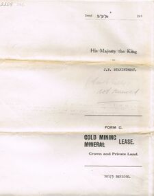
Mining lease 5 page document for lease application 10173, dated 9th March 1934, within area bounded by Don, Barnard Streets up to Mt. Korong Road, area 10 acres. Document signed by John Jepson Stanistreet in the presence of W.A. Kell, Warden's Clerk, Bendigo. Hand coloured plan of lease appended to document, yellow section refers to lease. Marked on map Central Garden Gully shaft. On front of lease ' entered in the Register Book Vol 303 Fol 33698' On back ' His Majesty the King to J.P. Stanistreet (Cent G Gully not renewed written in pencil) Form C Gold Mining Lease Crown and Private Land'gold, mining, garden gully shaft -
 Bendigo Historical Society Inc.
Document - MCCOLL, RANKIN AND STANISTREET COLLECTION: VICTORIAN GOLD ASSOCIATION, 1931
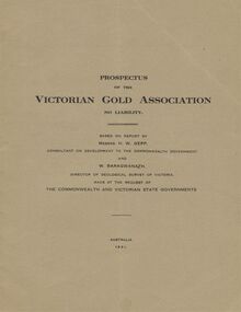
Prospectus of the Victorian Gold Association N.L. Based on a report by Messrs H. W. Gepp Consultant on Development to the Commonwealth Government and W. Baragwanath, Director of the Geological Survey of Victoria. Dated 1931 This company was formed to investigate the Deborah Mine, The Central Nell Gwynne Mine and the Monument Hill Mine. 12 pages including maps and Transverse Sections of the MinesThe Commonwealth and Victorian State Governments. E. Whitehead & Co., Pty., Ltd Printers 21 Equitale Place, Melbourne, C1.gold, mining, prospectus, bendigo, gold mines, victorian gold associatian, deborah mine, central nell gwynne mine, monument hill mine. -
 Bendigo Historical Society Inc.
Document - MCCOLL, RANKIN AND STANISTREET COLLECTION: CENTRAL GARDEN GULLY
Manilla Folder containing correspondence and applications for a mining lease on the Garden Gully Line known as Mumford's Claim, also contains maps of lease numbers 9993, 10173, and 10390 (all on the Garden Gully Line).McColl Rankin & Stanistreet, Charing Cross Bendigogold mining, miners' safety cage, central garden gully, mining, gold mines, bendigo, garden gully, mumfords claim -
 Bendigo Historical Society Inc.
Document - MARKS COLLECTION: ABE LINCOLN CO LEASE
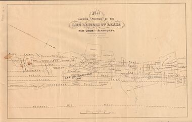
Two copies of plan for Abe Lincoln Co. Lease, New Chum, Sandhurst. One original, one copy. On top of plan 'Plan Showing Position of the Abe Lincoln Co. Lease, New Chum, Sandhurst' under name 'by H.B. Nicholas, Mining Surveyor' Sheepshead Reef, Easter reef, Alfred Reef, Allingham Reef,Adventure Reef, Belle Vue Reef, New Chum Reef, Black Lead, Victoria Reef lines shown on map with mine leases marked. On bottom of map 'Monument Hill Reef' line marked.bendigo, mining, abe lincoln lease -
 Bendigo Historical Society Inc.
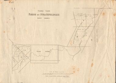
Document - MARKS COLLECTION: MAP OF PARISH OF STRATHFIELDSAYE 1858, 8th September, 1858
... Inc. History House 11 Mackenzie Street Bendigo goldfields MAP ...Buff coloured document. On top 'Country Lands, Parish of Strathfieldsaye, County Unnamed'. On bottom 'Scale 40 chains to an inch. Public Lands Office, Melbourne Sept 8th. 1858. William Collis, Lith ( lithographer )'. Map shows Village Reserve on Emu Creek, road from Sandhurst, Sheepwash Creek and Splitters Creek. Wellington Hotel marked on map near intersection of Sheepwash Creek, Axe Creek and Emu Creek. Axe Creek Pound near Splitters Creek.map, bendigo, parish of strathfieldsaye 1858 -
 Bendigo Historical Society Inc.
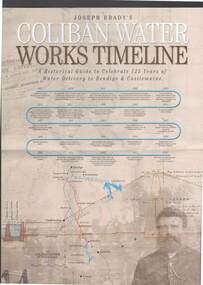
Document - JOSEPH BRADY COLLECTION: COLIBAN SYSTEM OF WATER WORKS PAMPHLET
Three copies of Joseph Brady's Coliban System of Water Works - A Historical Guide to Celebrate 125 Years of Water Delivery to Bendigo & Castlemaine by Coliban Water. Mentioned in the brochure is Gold & Water, The Original Coliban System of Water Works, The Coliban System Today, The Coliban Engineer - Joseph Martin Brady (1828 - 1908), Coliban System of Water Works Key Facts & Figures, The Aqua Project, Historical Guide, Coliban System of Water Works Map, photo of Joseph Brady, Photo of gold diggers and channel works.Coliban Watercivil engineering, water supply, coliban, joseph brady's coliban system of water works, coliban water, the original coliban system of water works, the coliban system today, joseph martin brady 1828 - 1908, gavan prendergast, coliban system of water works key facts & figures, the aqua project, historical guide to 125 years of water delivery to bendigo & castlemaine, map of system -
 Bendigo Historical Society Inc.
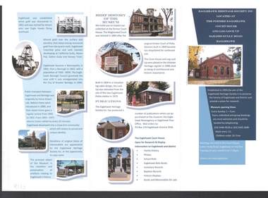
Document - EAGLEHAWK HERITAGE SOCIETY INC BROCHURE
Coloured brochure which contains a brief history of Eaglehawk, opening times for the Museum, a map with points of interest, application for Membership form, a brief history of the Museum, where Publications can be obtained and Research and Displays.eaglehawk heritage society inc brochure, former eaglehawk court house, log lock up, eaglehawk borough council, city of greter bendigo, court of petty sessions, eaglehawk newsagency, eaglehawk post office -
 Bendigo Historical Society Inc.
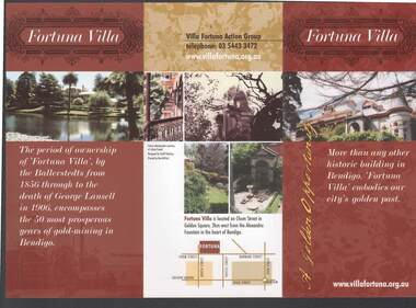
Document - FORTUNA COLLECTION: FORTUNA VILLA
Coloured tri-fold brochure titled Fortuna Villa. There are several coloured photos of the Villa and garden, a short history, information on the Villa Fortuna Action Group and their ideas for its future use. There is also a printed membership form. A small location map is included.bendigo, clubs, fortuna villa, christopher ballerstedt, theodore ballerstedt, 180 mine, george lansell, edith lansell, william beebe, vahland, getzschmann, emil maumann, commonwealth department of defence, the fortuna villa action group, city of greater bendigo, julian prowd, geoff hocking, bart-n-print -
 Bendigo Historical Society Inc.
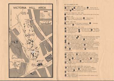
Map - VICTORIA HILL AREA
... Inc. History House 11 Mackenzie Street Bendigo goldfields MAP ...Map of Victoria Hill Area printed on yellow paper. Details of tracks, cuttings, contours (in Metres) and Anticline. Location of mines, open cuts and buildings are shown. Numbers on map are: Ballerstedt's Claim 1 - 5; North Old Chum Co. 6; Lansell's 180, 7,8,11; Battery 9.10.12; Victoria Quartz Co. 13 - 17; Rae's Open Cut and Vicinity 18 - 28, Great Central Victoria Co 29 - 36, Adventure and Advance Area and vicinity 37 - 40 and Victoria Consols Co 41.map, bendigo, victoria hill, victoria hill area, victoria consols, new chum anticline, great central victoria, rae's open cut, w rae's home, victoria quartz, ballerstedt's open cut, lansell's 180, north old chum, central nell gwynne, john brown factory, gold mines hotel, cleopatra needle type chimney, floyd's battery, ballerstedt's 24yd claim, humboldt shaft, wittscheibe's jeweller's shop, luffsman and sterry's claim, victoria hill reserve, mines dept reervation -
 Bendigo Historical Society Inc.
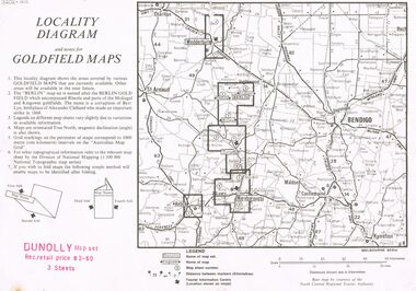
Document - JOAN O'SHEA COLLECTION: LOCALITY DIAGRAM AND NOTES FOR DUNNOLLY GOLDFIELD MAPS
Joan O'Shea Collection. Locality diagram and notes for goldfield maps. Dunolly map set. Wedderburn, Berlin, Dunolly, Maryborough, Avoca.mining, company exploration, dunolly map set. -
 Bendigo Historical Society Inc.
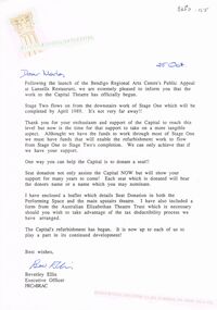
Document - MERLE HALL COLLECTION: CORRESPONDENCE FROM BENDIGO REGIONAL ARTS CENTRE
Correspondence from Bendigo Regional Arts Centre to Merle Hall, Sec Arts Bendigo - 25th Oct (1988) re work to Capital Theatre and Seat Donation; 6 December 1988 re donation from AB of $3000 to Capital Theatre project; November 12 1993 re donation from AB as contribution towards cost of purchasing a map cabinet - handwritten note on letter re the amount of that cheque ?? And comment that the donation never shown in the plaque on the cabinet; 20 June 1997: Reconciliation of the Soul Food recital of Gudrun Beilharz and Peter Bartels (loss). -
 Bendigo Historical Society Inc.
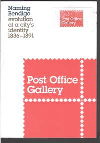
Book - NAMING BENDIGO: EVOLUTION OF A CITY'S IDENTITY 1836 TO1891
Red and white covered booklet titled 'Naming Bendigo evolution of a city's identity 1836 - 1891. It has a sketch map of Bendigo and Golden Square in 1851. It has a number of photos of early paintings, postcards and objects. The Foreword is written by Cr Rod Campbell, Mayor of the City of Greater Bendigo and the Introduction is written by Karen Quinlan, Director. The chapters are titled: Naming Bendigo evolution of a city's identity 1836 - 1891; The Gibson brothers soon renamed the run a popular choice in the 19th century; and to direct that the said place shall be called and known as Sandhurst; endeavoured to ascertain from what source, and at what time, the name of Bendigo arose: "The diggers...at Bendigo are recherché as to names;" and the Exhibition Checklist.event, exhibition, naming bendigo, naming bendigo - evolution of a city's identity 1836-1891, post office gallery, bendigo art galery, studio round, bambra, sandra bruce, karen quinlan, ian hill, national library of australia, city of greater bendigo, elaine harrington, vic lane, reg and judy macdonald, dennis o'hoy, sandhurst trustees, phil wilkins, darren wright, eaglehawk, eppalock, epsom, flora hill, golden square, kangaroo flat, strathfieldsaye, mount alexander run (north, or no 2 - ravenswood run -
 Bendigo Historical Society Inc.
Document - HERITAGE REPORT: FORMER POLICE STATION AND QUARTERS: CALIFORNIA GULLY
Seventeen page Heritage Place Report on the Former California Gully Police Station at 15 Thorpe Street, California Gully. It is the former police station and quarters, former timber stables and timber cottage residence demolished and horse paddock on separate title. Report includes a Statement of Significance, Place History (History of the Area), Policing California Gully Goldfields, History of the Buildings, Chronology of Ownership, Rate Books 1858, - 1867 - 1868, 1895 Borough of Eaglehawk Rates, 1922 Voters Roll, 1952 & 1962 Sands & McDougall Directory Thorpe St California Gully, Comparable Examples, Secondary Sources, Description Conservation Policy Guidelines (Specific), Physical Conditions, Physical Description 1, Map of Early Photo Location, Bendigo Parish Plan circa 1870, Certificate of Title 1950 & 1960. Pge 14 has plans, maps and an aerial photo of 15 Thorpe Street. Page 15 has an aerial photo of 15 Thorpe Street, California Gully with Allotment Size. Page 16 & 17 has photos.heritage, heritage report - former police station and quarters - california gully, city of greater bendigo, wilson & ass, butler, amanda jean, johnson reef shafts no 1 & 2, rose of denmark, princess dagmar, bendigo amalgamated goldfields company, captain frederick standish, royal irish constabulary, e thorpe, campbell, taylor, watson, brown, hosken, mckowne, mcqualter, parker, hicks, eaglehawk municipal council, victorian police force, d bannear, historic mining sites in the sandhurst eaglehawk and raywood mining divisions, department of conservation and natural resources, joshua thorpe, thorpe & co, johnson & co, william thorn, michael thomas, james murdock, edward c brown, francis youlden, gold escort, water police, mounted police, city police (melbourne), geelong police, gold fields police, rural bench constabulary, the people's force, robert haldane, n wild, streets of the borough of eaglehawk, police registration act, william henry mitchell, camp hotel, j o c nieman, j m catarach, g w hosken, margaret hosken nee mckown, majorie alice mcqualter, kellie anne mcqualter, adam joseph doolan, mr hicks, sands & mcdougall, hill george, meeking howard, mcewan frank a, jinks stanley, mccaig mrs eleanor, gordon john l, mcqualter mrs adeline, maher william l, raynor robert, flack john p, whitehead miss a, sang george t, linddsay john p, dyer henry, jackman george a, tibbetts mrs s a, hosken mrs margaret winifred nee mckowne, chaplin frank w, wilson c e, wright george, miller g a, sheyhill basil hugh, marshall r, miles j h, parker w b, barkla w g, nicholls les, cartledge clifford william, cole charles basil, farmers citizens trustees co, bev hanson -
 Bendigo Historical Society Inc.
Slide - DIGGERS & MINING. THE CHINESE ON THE GOLD FIELDS, c1850s
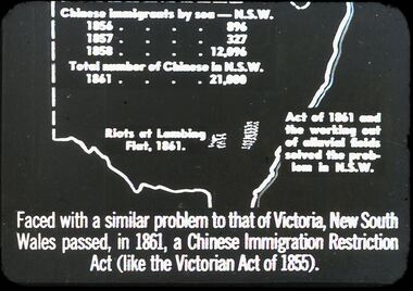
Diggers & Mining. The Chinese on the Gold Fields. Slide: Map of New South Wales. Chinese immigration by sea - N.S.W. 1856 - 896, 1857 - 327, 1858 - 12,096. Total number of Chinese in N.S.W. 1861 - 21,000. Riots of Lambing Flat, 1861. Act of 1861 the working out of alluvial fields solved the problem in N.S.W. Faced with a similar problem to that of Victoria, New South Wales passed, in 1861, a Chinese Immigration Restriction Act (like the Victorian Act of 1855). Markings: 10 994:LIF I. Used as a teaching aid.hanimounteducation, tertiary, goldfields -
 Bendigo Historical Society Inc.
Slide - DIGGERS & MINING. THE CHINESE ON THE GOLD FIELDS, c1870s
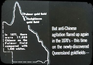
Diggers & Mining. The Chinese on the Gold Fields. Slide: But anti-Chinese agitation flared up again in 1870's - this time on the newly-discovered Queensland goldfields . . . Map on left is of Queensland: Palmer Goldfield, Hodgkinson gold field. In 1877, there were 17,000 Chinese on the Palmer field compared with 1,400 whites. Markings: 7. Used as a teaching aid.hanimounteducation, tertiary, goldfields