Showing 1565 items matching " allotments"
-
 Merbein District Historical Society
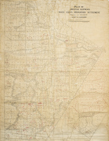
Plan - Plan, Allotments, Plan of Homestead Allotments White Cliffs Irrigation Settlement Parish of Merbein County of Karkarooc
... Plan of Homestead Allotments White Cliffs Irrigation Settlement Parish of Merbein County of Karkarooc...allotments...Written in red pen new owners of allotments...Some red ink added Plan of Homestead Allotments White Cliffs Irrigation Settlement Parish of Merbein County of Karkarooc Plan Plan, Allotments ...Large plan drawn in black ink on cream colour paper with linen backing. Some red ink addedWritten in red pen new owners of allotmentsallotments, merbein, irrigation, whitecliffs, county of karkarooc -
 Emerald Museum & Nobelius Heritage Park
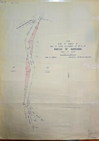
Map - Plan of Survey of Crown Allotments, Healesville - Koo Wee Rup Road, Shire of Berwick, c1969
... Plan of Survey of Crown Allotments, Healesville - Koo Wee Rup Road, Shire of Berwick...Image of Survey of Crown Allotments 61A, 61B & 81E, Parish of Nangana.../Plan of Survey of part of Crown Allotments 61A, 61B and 61E/Parish of Nangana, County of Evelyn/Shire of Berwick/Healesville0KooWeeRup Road.../Plan of Survey of part of Crown Allotments 61A, 61B and 61E/Parish of Nangana, County of Evelyn/Shire of Berwick/Healesville0KooWeeRup Road Image of Survey of Crown Allotments 61A, 61B & 81E, Parish of Nangana Plan of Survey of Crown Allotments, Healesville - Koo Wee Rup Road, Shire of Berwick Map Plan of Survey of Crown Allotments, Healesville - Koo Wee Rup Road, Shire of Berwick ...Image of Survey of Crown Allotments 61A, 61B & 81E, Parish of NanganaC.R.B./Plan of Survey of part of Crown Allotments 61A, 61B and 61E/Parish of Nangana, County of Evelyn/Shire of Berwick/Healesville0KooWeeRup Road -
 Emerald Museum & Nobelius Heritage Park
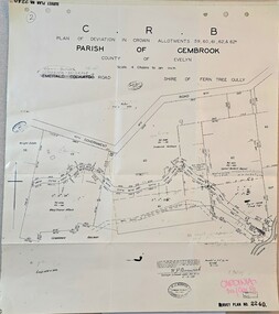
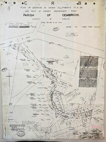
Map - Plan of deviation in Crown Allotments - parish of Gembrook, Gembrook-Belgrave Rd, Alterations to allotments 59, 60, 61,62 & 62A for the formation of Belgrave-Gembrook Rd., 1929, c1929
... Alterations to allotments 59, 60, 61,62 & 62A for the formation of Belgrave-Gembrook Rd., 1929...Image of Plan of deviation in Crown Allotments - parish of Gembrook, Gembrook-Belgrave Rd., allotments 59, 60, 61,62 & 62A...CRB/Plan of deviation in Crown Allotments 59, 60, 61, 62 & 62A/Parish of Gembrook, County of Evelyn/Scale 4 chains to an inch/Gembrook-Belgrave Road/certification of plan (signed) WP BONWICK, Surveyor Licensed under Act 2679/5-2-29/Survey Plan 2240...Emerald Museum & Nobelius Heritage Park 5 Crichton Rd Emerald yarra-valley-and-the-dandenong-ranges CRB/Plan of deviation in Crown Allotments 59, 60, 61, 62 & 62A/Parish of Gembrook, County of Evelyn/Scale 4 chains to an inch/Gembrook-Belgrave Road/certification of plan (signed) WP BONWICK, Surveyor Licensed under Act 2679/5-2-29/Survey Plan 2240 Image of Plan of deviation in Crown Allotments - parish of Gembrook, Gembrook-Belgrave Rd., allotments 59, 60, 61,62 & 62A Alterations to allotments 59, 60, 61,62 & 62A for the formation of Belgrave-Gembrook Rd., 1929 Map Plan of deviation in Crown Allotments - parish of Gembrook, Gembrook-Belgrave Rd., ...Image of Plan of deviation in Crown Allotments - parish of Gembrook, Gembrook-Belgrave Rd., allotments 59, 60, 61,62 & 62ACRB/Plan of deviation in Crown Allotments 59, 60, 61, 62 & 62A/Parish of Gembrook, County of Evelyn/Scale 4 chains to an inch/Gembrook-Belgrave Road/certification of plan (signed) WP BONWICK, Surveyor Licensed under Act 2679/5-2-29/Survey Plan 2240 -
 Emerald Museum & Nobelius Heritage Park
Map - Plan of Deviation in Crown Allotments 57 & 58 Wright Rd. & McNamara Rd. 1929, Property Acquisition Settlement Advice and plan of deviation in crown allotments in Wright Rd. and McNamara Rd, C 1929 & C 1984
... Property Acquisition Settlement Advice and plan of deviation in crown allotments in Wright Rd. and McNamara Rd....Images of map and letter pertaining to land acquisition and deviation plan for crown allotments adjacent to Crown Allotments 57 & 58.../Survey Plan 2239/Owner Roy and Judith Ward/dated 10 September, 1984/Signed P J McCulloch, General Manager Admin/ATTACHED MAP/Plan of Deviation in Crown Allotments 57 & 58and part of the formergovernment road, Parish of Gembrook, county of Evelyn/ certified by W.P. ...BONWICH - 5.2.29 Images of map and letter pertaining to land acquisition and deviation plan for crown allotments adjacent to Crown Allotments 57 & 58 Property Acquisition Settlement Advice and plan of deviation in crown allotments in Wright Rd. and McNamara Rd. ...Images of map and letter pertaining to land acquisition and deviation plan for crown allotments adjacent to Crown Allotments 57 & 58Road Construction Authority/Property Acquisition - Settlement advice letter addressd to General manager of Shire of Sherbrooke, Glanfern Way Upwey/Road - Belgrave-Gembrook Rd./Survey Plan 2239/Owner Roy and Judith Ward/dated 10 September, 1984/Signed P J McCulloch, General Manager Admin/ATTACHED MAP/Plan of Deviation in Crown Allotments 57 & 58and part of the formergovernment road, Parish of Gembrook, county of Evelyn/ certified by W.P. BONWICH - 5.2.29 -
 Merbein District Historical Society
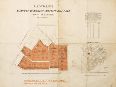
Map - Allotments Extension of Mildura-Merbein Mid-Area, Allotments available, 23 November 1920
... Allotments available...Allotments available to Discharged Soldiers Discharged Soldier's Settlement Act ...Large map, folded in 4, coloured map of Merbein indicating allotments available and locality plan. Scale 10 chain to 1 inch...Butson 23.11.20 Large map, folded in 4, coloured map of Merbein indicating allotments available and locality plan. Scale 10 chain to 1 inch Allotments available Map Allotments Extension of Mildura-Merbein Mid-Area ...Allotments available to Discharged Soldiers Discharged Soldier's Settlement Act Historic Large map, folded in 4, coloured map of Merbein indicating allotments available and locality plan. Scale 10 chain to 1 inchPhoto-Lithographed at Department of lands Survey, Melbourne J. Butson 23.11.20discharged soldiers, ww1, soldier settlement, irrigation -
 Ringwood and District Historical Society
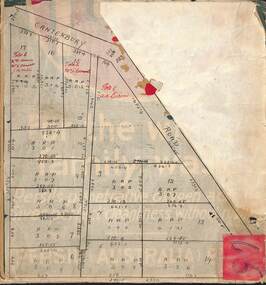
Map, Subdivision Plan of residential allotments on Canterbury Road, Bayswater (later surrounding Miller Road, Heathmont), Victoria - (Undated - circa 1930s)
... Subdivision Plan of residential allotments on Canterbury Road, Bayswater (later surrounding Miller Road, Heathmont), Victoria - (Undated - circa 1930s)...Includes red pen notations marking allotments sold to Mrs A. Harrison, Mrs C Cornwall, J.M. ...Red pen notations mark allotments sold to Mrs A. Harrison, Mrs C Cornwall, J.M. ...Includes red pen notations marking allotments sold to Mrs A. Harrison, Mrs C Cornwall, J.M. ...Hand-drawn map on cardboard backing. Includes red pen notations marking allotments sold to Mrs A. Harrison, Mrs C Cornwall, J.M. Miller, and A.W. Dickson.Red pen notations mark allotments sold to Mrs A. Harrison, Mrs C Cornwall, J.M. Miller, and A.W. Dickson. Later subdivision of the map area took in Miller Road and Atunga Court developments. -
![Map, Plan of Subdivision [Allotments along Lerderderg, George and McFarland Streets]](/media/collectors/5e461d8021ea67224c82f2a1/items/675d7243165f146b8adfc656/item-media/675d72d7165f146b8adfc859/item-fit-380x285.jpg?cb=6) Bacchus Marsh & District Historical Society
Bacchus Marsh & District Historical SocietyMap, Plan of Subdivision [Allotments along Lerderderg, George and McFarland Streets]
... Plan of Subdivision [Allotments along Lerderderg, George and McFarland Streets]...Larger allotments of land are shown extending northwards towards Masons Lane. ...Single page map showing house block size land allotments in the Lerderderg, George Street and McFarland Street area of Bacchus Marsh with larger allotments north of this area towards Masons Lane also shown. ...Bacchus Marsh Victoria Maps Lerderderg Street Land Allotments McFarland Street Land Allotments Single page map showing house block size land allotments in the Lerderderg, George Street and McFarland Street area of Bacchus Marsh with larger allotments north of this area towards Masons Lane also shown. ...This map shows allotments of land on the northern side of Lerderderg Street from Gisborne Road through to the approximate site of the present day Bacchus Marsh Primary School. There are also allotments shown on the southern side of McFarland Street between George Street and Gisborne Road. Larger allotments of land are shown extending northwards towards Masons Lane. Inscribed at the top of the map are the words, 'Plan of Subdivision of Cr Pors (Crown Portions) 12 & 13 & Allotments 1,2,3,4, Block 3, Parish of Korkuperrimul, County of Bourke'. The date of the map has not been established but the absence of the Bacchus Marsh Primary School on the map suggests it may have been produced prior to 1865 when the primary school was built in Lerderderg Street.Single page map showing house block size land allotments in the Lerderderg, George Street and McFarland Street area of Bacchus Marsh with larger allotments north of this area towards Masons Lane also shown. Scale 150 feet to 1 inch. Part of a set of maps which are pasted into a bound volume containing 76 maps or plans in total. High resolution digital image stored on BMDHS computer network. bacchus marsh victoria maps, lerderderg street land allotments, mcfarland street land allotments -
 Bacchus Marsh & District Historical Society
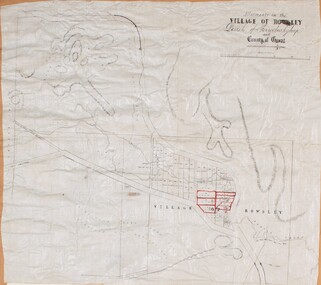
Map, Allotments in the Village of Rowsley, Parish of Gorrocburkghap, County of Grant c.1856
... Allotments in the Village of Rowsley, Parish of Gorrocburkghap, County of Grant c.1856...SLV reference: 'Allotments in the Village of Rowsley, Parish of Gorrocburkghap, County of Grant', by T. ...Allotments 8, and 10-16 are outlined in red ink and allotment 9 has a cross in red ink on it. ...Allotments 8, and 10-16 are outlined in red ink and allotment 9 has a cross in red ink on it. ...Rowsley is a locality 11 kilometers south-west of Bacchus Marsh. The date of this map is uncertain. A very similar map held by the State Library of Victoria (SLV) contains slightly more information than this copy and is dated as an 1856 map. SLV reference: 'Allotments in the Village of Rowsley, Parish of Gorrocburkghap, County of Grant', by T. Nixon, Assistant Surveyor, May 1856 ; Surveyor General’s Office, July 18 1856 (lithographed by R. Meikle). (1856). Melbourne: Surveyor General’s Office. MAPS 820 BJE 1837- ROWSLEY 1856. A single page paper map. A cadastral map of the Village of Rowsley in Victoria, showing numbered land allotments. 57 allotments are shown on the map and some areas set aside as reserves. Allotments 8, and 10-16 are outlined in red ink and allotment 9 has a cross in red ink on it. The map is pasted into a bound volume containing 76 maps or plans in total. High resolution digital image stored on BMDHS computer network. rowsley victoria history, rowsley victoria maps -
 Emerald Museum & Nobelius Heritage Park
Map - Image of Plan of Deviation in Crown Allotments 57 & 58, Belgrave-Gembrook Rd., near Wright Rd. 1929, Plan of Deviation in Crown Allotments 57 & 58, Belgrave-Gembrook Rd., near Wright Rd. 1929, c1929
... Plan of Deviation in Crown Allotments 57 & 58, Belgrave-Gembrook Rd., near Wright Rd. 1929...Crown survey map showing plan of deviation in crown allotments 57 & 58, Belgrave-Gembrook Rd., near Wrights Rd., Parish of Gembrook...CRB/Plan of Deviation in Crown Allotments 57 & 58 and Part of Former Government Road/Parish of Gembrook, County of Evelyn/Belgrave-Gembrook Rd....BONWICK, Surveyor Licensed under Act 2679/5-2-29/Survey Plan No. 2239 Crown survey map showing plan of deviation in crown allotments 57 & 58, Belgrave-Gembrook Rd., near Wrights Rd., Parish of Gembrook Plan of Deviation in Crown Allotments 57 & 58, Belgrave-Gembrook Rd., near Wright Rd. 1929 Map Image of Plan of Deviation in Crown Allotments 57 & 58, Belgrave-Gembrook Rd., near Wright Rd. 1929 ...Crown survey map showing plan of deviation in crown allotments 57 & 58, Belgrave-Gembrook Rd., near Wrights Rd., Parish of GembrookCRB/Plan of Deviation in Crown Allotments 57 & 58 and Part of Former Government Road/Parish of Gembrook, County of Evelyn/Belgrave-Gembrook Rd./Scale 100 foot to an inch/Certification of Plan (Signed) W.P. BONWICK, Surveyor Licensed under Act 2679/5-2-29/Survey Plan No. 2239 -
 Emerald Museum & Nobelius Heritage Park
Map - Survey Map - Municipality Road Classification - Beaconsfield-Emerald Rd. (near Downey Rd.) 1972, Title Survey Division, Crown Description - part of Crown Allotments 39A and 39D, Parish of Gembrook, County of Mornington, c1972
... Title Survey Division, Crown Description - part of Crown Allotments 39A and 39D, Parish of Gembrook, County of Mornington...Image of Crown survey map - changes to allotments bordering Beaconsfield-Emerald Rd. near Downey Rd. in 1972...Title Survey Division/Crown Description/Part of Crown Allotments 39A and 39D, Parish of Gembrook,County of Mornington/Municipality Road Classification - Shire of Berwick, Beaconsfield - Emerald Rd, Upper Beaconsfield - Upper Pakenham Road/John L Dwyer of Fisher Cleeland Turner & Dwyer Pty. ...CLARKE - Principal Title Survey Officer 5.9.72/SP 13072 Image of Crown survey map - changes to allotments bordering Beaconsfield-Emerald Rd. near Downey Rd. in 1972 Title Survey Division, Crown Description - part of Crown Allotments 39A and 39D, Parish of Gembrook, County of Mornington Map Survey Map - Municipality Road Classification - Beaconsfield-Emerald Rd. ...Image of Crown survey map - changes to allotments bordering Beaconsfield-Emerald Rd. near Downey Rd. in 1972Title Survey Division/Crown Description/Part of Crown Allotments 39A and 39D, Parish of Gembrook,County of Mornington/Municipality Road Classification - Shire of Berwick, Beaconsfield - Emerald Rd, Upper Beaconsfield - Upper Pakenham Road/John L Dwyer of Fisher Cleeland Turner & Dwyer Pty. Ltd., 213 King Street, Melbourne - 14 April, 1972/S.R. CLARKE - Principal Title Survey Officer 5.9.72/SP 13072 -
 Bacchus Marsh & District Historical Society
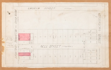
Map, Main Road and Gell Street Allotments
... Main Road and Gell Street Allotments ...The total area of the map encompasses Main Road, Church Street, Lerderderg Street and Gell Street. 36 allotments of land are shown. Three allotments which connect to Main Road are shaded in pink. ...Single page map showing allotments of land along the Main Road (Main Street) and Gell Street areas of Bacchus Marsh. ...Later reports in the Express on 1 November 1873, page 2, column 2 advertised 14 allotments of land in Gell Street for sale. Bacchus Marsh Victoria Maps Gell Street Land Allotments Main Street Land Allotments Single page map showing allotments of land along the Main Road (Main Street) and Gell Street areas of Bacchus Marsh. ...This map shows allotments of land along Gell Street Bacchus Marsh running between Main Road (now called Main Street) and Lerderderg Street. The total area of the map encompasses Main Road, Church Street, Lerderderg Street and Gell Street. 36 allotments of land are shown. Three allotments which connect to Main Road are shaded in pink. The date of the map has not been established but the National Bank building erected in 1865 near the Border Inn is indicated which indicates that the map dates from after 1865. Reports in the Bacchus Marsh Express newspaper on 5 March 1870, page 2, column 6 announced building lots in Gell Street had been withdrawn from sale by the agent J.E. Crook. Later reports in the Express on 1 November 1873, page 2, column 2 advertised 14 allotments of land in Gell Street for sale. Single page map showing allotments of land along the Main Road (Main Street) and Gell Street areas of Bacchus Marsh. Part of a set of maps which are pasted into a bound volume containing 76 maps or plans in total. High resolution digital image stored on BMDHS computer network. bacchus marsh victoria maps, gell street land allotments, main street land allotments -
 Bacchus Marsh & District Historical Society
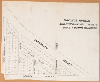
Map, Bacchus Marsh Suburban Allotments Parwan Road Lodge & Dunn's Paddocks 1888
... Bacchus Marsh Suburban Allotments Parwan Road Lodge & Dunn's Paddocks 1888...The auction took place on 23 October 1888. 102 allotments of land from an area known as Lodge and Dunn's paddocks was offered for sale. ...A single page paper map showing allotments of land for sale along the Parwan Road in Maddingley. ...Bacchus Marsh Suburban Allotments Parwan Road Lodge & Dunn's Paddocks 1888 Map Shire of Bacchus Marsh ...This map was created as a plan for an auction of land close to the Bacchus Marsh Railway Station. The auction took place on 23 October 1888. 102 allotments of land from an area known as Lodge and Dunn's paddocks was offered for sale. A single page paper map showing allotments of land for sale along the Parwan Road in Maddingley. The map is pasted into a bound volume containing 76 maps or plans in total. High resolution digital image stored on BMDHS computer network. land sales bacchus marsh, land sales maddingley, bacchus marsh victoria maps, maddingley victoria maps -
 Ringwood and District Historical Society
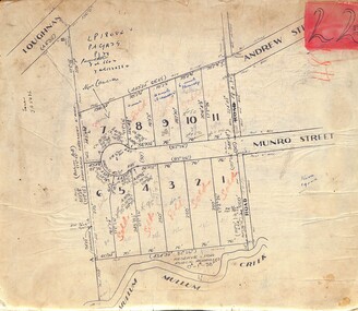
Map, Subdivision Plan of residential allotments in Munro Street, Ringwood, Victoria - (Undated, circa 1920s)
... Subdivision Plan of residential allotments in Munro Street, Ringwood, Victoria - (Undated, circa 1920s)...Map of residential allotments on cardboard backing....Map of residential allotments on cardboard backing. Subdivision Plan of residential allotments in Munro Street, Ringwood, Victoria - (Undated, circa 1920s) Map ...Map of residential allotments on cardboard backing.Handwritten notations include sales information and title references LP1884, Vol 6602, Fol 132038, with number of units on lots 8, 9 and 10. -
Stawell Historical Society Inc
Map, Special Allotments, Reefs, Pleasant Creek
... Special Allotments, Reefs, Pleasant Creek...Special Allotments, Reefs, Pleasant Creek...Stawell Historical Society Inc 46 Longfield St Stawell grampians Stawell Special Allotments, Reefs, Pleasant Creek Special Allotments, Reefs, Pleasant Creek Map ...Special Allotments, Reefs, Pleasant Creekstawell -
 Ringwood and District Historical Society
Map, Subdivision Plan of residential allotments in Caroline Street, Thomas Street, Emerald Street and Ford Street, Ringwood, Victoria - (Undated, circa 1930)
... Subdivision Plan of residential allotments in Caroline Street, Thomas Street, Emerald Street and Ford Street, Ringwood, Victoria - (Undated, circa 1930)....Map of residential allotments on blue cardboard backing....Map of residential allotments on blue cardboard backing. Subdivision Plan of residential allotments in Caroline Street, Thomas Street, Emerald Street and Ford Street, Ringwood, Victoria - (Undated, circa 1930). ...Map of residential allotments on blue cardboard backing.Handwritten title reference notation LP13641. -
 Ringwood and District Historical Society
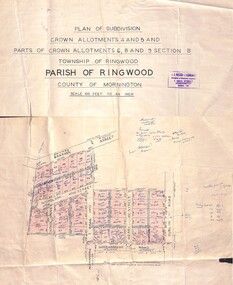
Map - Plan of Subdivision, Crown Allotments 4 and 5, and Parts of Crown Allotments 6, 8 and 9 Section B, Township and Parish of Ringwood, County of Mornington - Salter's Estate East Ringwood Victoria - 1956
... Crown Allotments 4 and 5, and Parts of Crown Allotments 6, 8 and 9 Section B, Township and Parish of Ringwood, County of Mornington - Salter's Estate East Ringwood Victoria - 1956...Land Title map of 51 allotments with property dimensions and handwritten real estate sales notations. ...Land Title map of 51 allotments with property dimensions and handwritten real estate sales notations. ...Land Title map of 51 allotments with property dimensions and handwritten real estate sales notations. Copy of map on cardboard backing - extracted from auction advertisement for Saturday, 10th November (1956).Subdivision includes Railway Avenue, Nicholson Street, Althol Grove (later Morcom Avenue), Illoura Avenue, Tweed Street, Merry Street, and Dublin Road, Ringwood East, Victoria. -
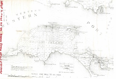 Phillip Island and District Historical Society Inc.
Document, 1869 Crown Land sale and map of Phillip Island showing allotments
... 1869 Crown Land sale and map of Phillip Island showing allotments....Copy of map showing allotments for 1869 land sale and hand written note showing allotments, area, prices for purchases of Robert Anderson and notes on McHaffie land....Listings of auctions at Gemmell, Tuckett & Co., Collins Street, Melbourne 12 February, 1869 Historical Robert Anderson Glen Isla John McHaffie maps Land sales Copy of map showing allotments for 1869 land sale and hand written note showing allotments, area, prices for purchases of Robert Anderson and notes on McHaffie land. 1869 Crown Land sale and map of Phillip Island showing allotments. ...Anderson and McHaffie were prominent early settlers of Phillip Island. These documents were from the estate of Stan Mcfee snr. Listings of auctions at Gemmell, Tuckett & Co., Collins Street, Melbourne 12 February, 1869HistoricalCopy of map showing allotments for 1869 land sale and hand written note showing allotments, area, prices for purchases of Robert Anderson and notes on McHaffie land.robert anderson, glen isla, john mchaffie, maps, land sales -
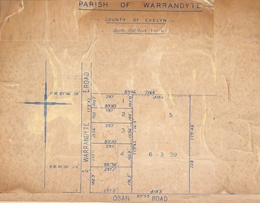 Ringwood and District Historical Society
Map, Subdivision Plan of 5 residential allotments on Warrandyte Road and Oban Road, Ringwood, Victoria - (Undated - pre 1950s)
... Subdivision Plan of 5 residential allotments on Warrandyte Road and Oban Road, Ringwood, Victoria - (Undated - pre 1950s)...Partial copy of Crown Allotment Map on cardboard backing...Partial copy of Crown Allotment Map on cardboard backing Subdivision Plan of 5 residential allotments on Warrandyte Road and Oban Road, Ringwood, Victoria - (Undated - pre 1950s) Map ...Partial copy of Crown Allotment Map on cardboard backingParish of Warrandyte, County of Evelyn. -
Lorne Historical Society
Map - Subdivision Map, J Batten Lithos, Plan of West Lorne Loutitt Bay Allotments IV and V
... Plan of West Lorne Loutitt Bay Allotments IV and V...Black and white printed map on cream paper. The map shows allotments from the Erskine River to the Grand Pacific with an inset of allotments between Smith and Otway Streets. ...Lorne subdivisions Black and white printed map on cream paper. The map shows allotments from the Erskine River to the Grand Pacific with an inset of allotments between Smith and Otway Streets. ...One of the early subdivision maps of Lorne.Black and white printed map on cream paper. The map shows allotments from the Erskine River to the Grand Pacific with an inset of allotments between Smith and Otway Streets. Allotments have the owners names.. The sea baths, Cobb and Co stables , Mountjoys Hotel, the Church of England, the telegraph line to Geelong and the jetty are also marked.lorne, subdivisions, -
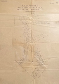 Ringwood and District Historical Society
Map - Plans of Subdivision, Part of Crown Allotments 35 & 39, Parish of Warrandyte
... Part of Crown Allotments 35 & 39, Parish of Warrandyte...Survey maps of stages 1, 2 & 3 of residential allotments in Kalinda Road and Grayling Crescent, Ringwood, Victoria. ...Part of Crown Allotments 35 & 39, Parish of Warrandyte Map Plans of Subdivision ...Survey maps of stages 1, 2 & 3 of residential allotments in Kalinda Road and Grayling Crescent, Ringwood, Victoria. (Undated, circa 1960). Some allotments are marked with real estate information and prices in pre decimal £s.Adshead & McGuire, Land Surveyors L.S. M.I.S. (Aust), 268 Albert Street East Melbourne (Ref 118/2a b &c) Tel 41-6960. The land colored blue is set apart for drainage & sewerage purposes. Reference Marks (R.M's) are Gal Iron Pipes 12"x1". Levels shown are to M.M.B.W. Datum. The land shown hatched is subject to innundation. -
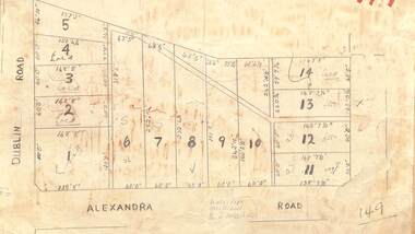 Ringwood and District Historical Society
Map - Subdivision Plan, Residential allotments - Dublin Road and Alexandra Road, Ringwood East, Victoria - (Undated)
... Residential allotments - Dublin Road and Alexandra Road, Ringwood East, Victoria - (Undated)...Hand-drawn map on light cardboard backing - 14 numbered allotments with property dimensions....Hand-drawn map on light cardboard backing - 14 numbered allotments with property dimensions. Residential allotments - Dublin Road and Alexandra Road, Ringwood East, Victoria - (Undated) Map Subdivision Plan ...Hand-drawn map on light cardboard backing - 14 numbered allotments with property dimensions.Handwritten real estate sales notations include lot 12 and lot 13 £550 each. -
Emerald Museum & Nobelius Heritage Park
Map - Municipality Road Classification - Wellington Rd. (part) - Near Kitty Street, Crown Survey map - Crown allotments 106F2 & 106 G1 - Wellington Rd. near Kitty Street, c1972
... Crown Survey map - Crown allotments 106F2 & 106 G1 - Wellington Rd. near Kitty Street...Image of Title survey - Part of Crown Allotments 106F2 and 106G1 - Wellington Road, Shire of Sherbrooke ...CLARKE, Principal Title Survey Officer & Proper Officer 21.6.72 Image of Title survey - Part of Crown Allotments 106F2 and 106G1 - Wellington Road, Shire of Sherbrooke Crown Survey map - Crown allotments 106F2 & 106 G1 - Wellington Rd. near Kitty Street Map Municipality Road Classification - Wellington Rd. ...Image of Title survey - Part of Crown Allotments 106F2 and 106G1 - Wellington Road, Shire of Sherbrooke SP12969/Title Survey Division/Crown Description/Part of Crown Alloments 106F2, 106F3 and 106G1, Parish of Narree Worran, County of Mornington/Municipality Road Classification/Shire of Sherbrooke, Wellington Road/(signed) Rossley Paul Gardner of Kirkpatrick & Webber, 280 Maroondah Highway, Ringwood, 29th March 1972/(Signed) S.R. CLARKE, Principal Title Survey Officer & Proper Officer 21.6.72 -
Merbein District Historical Society
Map, Plan Of Merbein West - Allotments 137-173, 12 Jul.1908
... Plan Of Merbein West - Allotments 137-173...... Allotments...Merbein District Historical Society 36 Box St Merbein the-murray Maps Allotments Merbein West Plan Of Merbein West - Allotments 137-173 Map ...maps, allotments, merbein west -
 Ringwood and District Historical Society
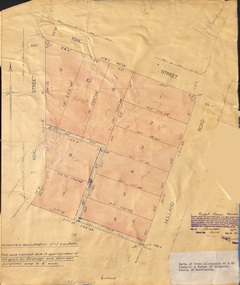
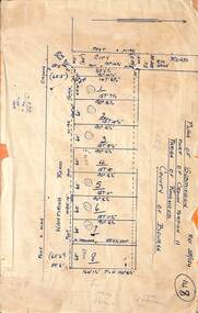
Document - Plan of Subdivision, Parts of Crown Allotments 45 & 46, Township & Parish of Ringwood, County of Mornington - 1950
... Parts of Crown Allotments 45 & 46, Township & Parish of Ringwood, County of Mornington - 1950....Map on manila folder attached to cardboard backing showing residential allotments on King Street and Holland Road, Ringwood East....Parts of Crown Allotments 45 & 46, Township & Parish of Ringwood, County of Mornington - 1950. ...Map on manila folder attached to cardboard backing showing residential allotments on King Street and Holland Road, Ringwood East.Signature of Russell Francis Kinnane, Licensed Surveyor, 4th December, 1950. -
 Ringwood and District Historical Society
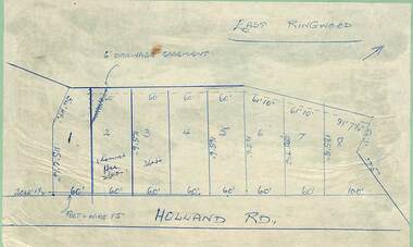
Map - Subdivision Plans, Residential allotments in Holland Road, Ringwood East, Victoria - (Undated - circa 1950s)
... Residential allotments in Holland Road, Ringwood East, Victoria - (Undated - circa 1950s)...Hand-drawn map on light cardboard backing - 8 numbered allotments on Holland Road (north of Everard Road - not shown)....Residential allotments in Holland Road, Ringwood East, Victoria - (Undated - circa 1950s) Map Subdivision Plans ...Hand-drawn map on light cardboard backing - 8 numbered allotments on Holland Road (north of Everard Road - not shown). -
![Map, Plan of Town Allotments Bacchus Marsh [1891-1897]](/media/collectors/5e461d8021ea67224c82f2a1/items/66acc1c90c778f9f64a3daec/item-media/66acc3990c778f9f64a3e09b/item-fit-380x285.jpg?cb=6) Bacchus Marsh & District Historical Society
Bacchus Marsh & District Historical SocietyMap, Plan of Town Allotments Bacchus Marsh [1891-1897]
... Plan of Town Allotments Bacchus Marsh [1891-1897]...This plan of town allotments in Lerderderg Street and Bennett Street also includes the location of many of the buildings, shops, businesses and houses which were present in the retail and business area of Bacchus Marsh in the 1890s. ...A single page paper plan showing allotments of land fronting Lerderderg and Bennett Street. ...Bacchus Marsh Victoria Maps Shops Bacchus Marsh A single page paper plan showing allotments of land fronting Lerderderg and Bennett Street. ...This plan of town allotments in Lerderderg Street and Bennett Street also includes the location of many of the buildings, shops, businesses and houses which were present in the retail and business area of Bacchus Marsh in the 1890s. The precise date of the plan is not known but it must be sometime between 1891 and 1897. The Post Office and the Wesleyan Church are both shown on this plan. Both of these were constructed in 1890. The plan does not show the Baptist Church in Main Street which was constructed in 1898. Hence the date is sometime between 1891 and 1897.This plan of Bacchus Marsh is one of the most detailed visual representations of the location of shops, businesses and houses in the central part of Bacchus Marsh. It provides very precise locations of most of the shops and houses in the town in the 1890s. A single page paper plan showing allotments of land fronting Lerderderg and Bennett Street. Buildings, businesses and houses along most of the streets are identified by hand written annotations. Streets identified on plan: Lerderderg Street - Bennett Street - Main Street - Gell Street - Young Street - Graham Street. Physical boundaries of the map are: North border - Lerderderg Street - South border - Main Street - West border Gell Street - East border - Young Street. The plan is pasted into a bound volume containing 76 maps or plans in total. bacchus marsh victoria maps, shops bacchus marsh -
 Ringwood and District Historical Society
Map, Subdivision Plan - 8 residential allotments south of City Road on Wantirna Road, Ringwood, Victoria - (Undated - circa 1950s)
... Subdivision Plan - 8 residential allotments south of City Road on Wantirna Road, Ringwood, Victoria - (Undated - circa 1950s)...Part of Crown Portion 11, Parish of Ringwood, County of Bourke. Some allotments include real estate sales notations. ...Subdivision Plan - 8 residential allotments south of City Road on Wantirna Road, Ringwood, Victoria - (Undated - circa 1950s) Map ...Hand-drawn map on cardboard backing.Part of Crown Portion 11, Parish of Ringwood, County of Bourke. Some allotments include real estate sales notations. (North arrow incorrectly points east.) -
Linton and District Historical Society Inc
Certificate of Title, Certificate of Title : Crown Allotments 27, 28, 29, 30, Section 4, Township of Linton
... Certificate of Title : Crown Allotments 27, 28, 29, 30, Section 4, Township of Linton...James and Theo Nelson later (1955) acquired Allotment 36, Section 4 which adjoins these allotments...James and Theo Nelson later (1955) acquired Allotment 36, Section 4 which adjoins these allotments Theophilus William Nelson James Adolphus Nelson Certificates of Title Allotments 27 - 30 Township of Linton Copy of Certificate of Title for several adjacent blocks of land on the corner of Clyde Street and Grantley Street in Linton. ...The land was transferred to Theophilus William Nelson and James Adolphus Nelson in 1929. James and Theo Nelson later (1955) acquired Allotment 36, Section 4 which adjoins these allotmentsCopy of Certificate of Title for several adjacent blocks of land on the corner of Clyde Street and Grantley Street in Linton. Copy is comprised of photostat sheets held together by tape.theophilus william nelson, james adolphus nelson, certificates of title, allotments 27 - 30 township of linton -
 Ringwood and District Historical Society
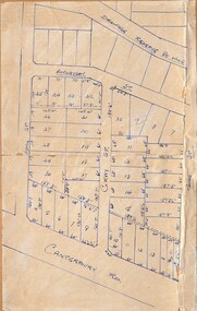
Map - Subdivision Plans, Residential allotments in Canterbury Road, Hume Street, Finlayson Street, Gray Street (later Grayview Avenue), and Thomas Street (later Gracedale Avenue), Ringwood East, Victoria - (Undated - circa 1950s)
... Residential allotments in Canterbury Road, Hume Street, Finlayson Street, Gray Street (later Grayview Avenue), and Thomas Street (later Gracedale Avenue), Ringwood East, Victoria - (Undated - circa 1950s)...Multiple sets of numbered allotments, with un-numbered lots adjoining a drainage reserve north of Finlayson Street....Multiple sets of numbered allotments, with un-numbered lots adjoining a drainage reserve north of Finlayson Street. ...Hand-drawn map on light cardboard backing. Multiple sets of numbered allotments, with un-numbered lots adjoining a drainage reserve north of Finlayson Street. -
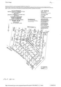 Ringwood and District Historical Society
Document - Subdivision Plan, LP26914 Multiple Crown Allotments, Parish of Ringwood, County of Mornington, Vol 8021 Fol 053 - 1954
... LP26914 Multiple Crown Allotments, Parish of Ringwood, County of Mornington, Vol 8021 Fol 053 - 1954...Part of Crown Allotments 1, 1A, 2, 3, 4, 5, 6, 7, 8, 9, 10, 55, 56, 57. ...Ringwood and District Historical Society 125A Warrandyte Road Ringwood North melbourne Part of Crown Allotments 1, 1A, 2, 3, 4, 5, 6, 7, 8, 9, 10, 55, 56, 57. ...LANDATA Land Victoria plan printout dated 2010Part of Crown Allotments 1, 1A, 2, 3, 4, 5, 6, 7, 8, 9, 10, 55, 56, 57. Section C Crown Allotments 3, 12 & part of 2. Section B Map includes Bedford Road, Government Road (later Bedford Park Road then Hill Street), Marwarra Street and Tooronga Road, Ringwood. (Sheet 1 of 2 - Sheet 2 not included with collection).