Showing 40 items matching " canterbury towers"
-
 Canterbury History Group
Article, No takers yet for Chaucer's & Aged home for Chaucer's
... ... Canterbury Towers...Canterbury History Group 190A Canterbury Road Canterbury melbourne Canterbury Canterbury Road Chaucer's Reception Centre Canterbury Towers Retirement Homes and Villages Two articles from the Progress Press relating to the proposed sale and development of Chaucer's Reception Centre in 2000. ...Two articles from the Progress Press relating to the proposed sale and development of Chaucer's Reception Centre in 2000.Two articles from the Progress Press relating to the proposed sale and development of Chaucer's Reception Centre in 2000.canterbury, canterbury road, chaucer's reception centre, canterbury towers, retirement homes and villages -
Canterbury History Group
Photograph - Public Library Canterbury, c1920s
... ... Canterbury Gardens... Libraries... Towers...Canterbury History Group 190A Canterbury Road Canterbury melbourne Canterbury Canterbury Library Canterbury Road Canterbury Gardens Libraries Towers Verandahs Black and white photograph of the Canterbury Public Library, Canterbury Road Canterbury c1920s Photograph Public Library Canterbury ...Black and white photograph of the Canterbury Public Library, Canterbury Road Canterbury c1920scanterbury, canterbury library, canterbury road, canterbury gardens, libraries, towers, verandahs -
Canterbury History Group
Photograph - Canterbury Lawn Bowling Club members on the green
... Members on the green at 9 Wattle Valley Road Canterbury, the tower of Malone's Hotel can be seen on the skyline.Part of a set of four black and white photographs, names and date unknown....Canterbury History Group 190A Canterbury Road Canterbury melbourne Canterbury Canterbury Lawn Bowling Club Wattle Valley Road Bowling Clubs Malones Hotel Members on the green at 9 Wattle Valley Road Canterbury, the tower of Malone's Hotel can be seen on the skyline.Part of a set of four black and white photographs, names and date unknown. ...Members on the green at 9 Wattle Valley Road Canterbury, the tower of Malone's Hotel can be seen on the skyline.Part of a set of four black and white photographs, names and date unknown.canterbury, canterbury lawn bowling club, wattle valley road, bowling clubs, malones hotel -
Canterbury History Group
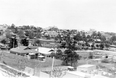
Photograph - Canterbury From the Tower Hotel, c1907
... Canterbury From the Tower Hotel...... Canterbury Road... Tower...Canterbury Road from Malone's Tower Hotel looking west c1907...Canterbury History Group 190A Canterbury Road Canterbury melbourne Canterbury Road from Malone's Tower Hotel looking west c1907 Canterbury Canterbury Road Tower Hotel Canterbury Railway Station Canterbury Gardens E.S & A Bank Goldings Hall J. ...Canterbury Road from Malone's Tower Hotel looking west c1907Black and white photographcanterbury, canterbury road, tower hotel, canterbury railway station, canterbury gardens, e.s & a bank, goldings hall, j. weymouth> ironmonger, pauls pharmacy, baptist church, canterbury library, horse drawn vehicles, railway stations -
Whitehorse Historical Society Inc.
Article, It's over at last for tower, 2015
... The Telstra communication tower on Canterbury Road, Surrey Hills is to be removed and replaced with a monopole structure following community outrage at proposed Heritage protection for the 45 metre tower....Whitehorse Historical Society Inc. 2-10 Deep Creek Road Mitcham melbourne Tower is to be removed and replaced with a monopole structure following community outrage at proposed Heritage protection for the 45 metre tower. Canterbury Road Surrey Hills Telstra The Telstra communication tower on Canterbury Road, Surrey Hills. ...The Telstra communication tower on Canterbury Road, Surrey Hills.The Telstra communication tower on Canterbury Road, Surrey Hills is to be removed and replaced with a monopole structure following community outrage at proposed Heritage protection for the 45 metre tower.The Telstra communication tower on Canterbury Road, Surrey Hills. canterbury road, surrey hills, telstra -
Box Hill Historical Society
Photograph - Aerial Photographs
... The water tower in Elgar Road and the communications tower in Canterbury Road is visible....The water tower in Elgar Road and the communications tower in Canterbury Road is visible. Whitehorse Plaza ANZ Bank Bank Street Station Street Main Street Shopping centres Banks Transport Water towers Telecommunications equipment Aerial photographs Photograph Aerial Photographs ...Aerial photograph of Bank street, Box Hill - looking west - showing the ANZ Bank on the corner of Station Street and Main Street, and Whitehorse Plaza in the background. C.1970's. Railway line visible through the trees. The water tower in Elgar Road and the communications tower in Canterbury Road is visible.whitehorse plaza, anz bank, bank street, station street, main street, shopping centres, banks, transport, water towers, telecommunications equipment, aerial photographs -
 Bendigo Historical Society Inc.
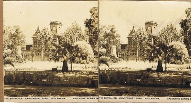
Photograph - OLIVE PELL COLLECTION: CANTERBURY PARK, EAGLEHAWK, 1860's
... A stereoscope card of the entrance to Canterbury Park, Eaglehawk, with the Eaglehawk Post Office showing the clock tower in the back ground, the clock is at 11.07am. ...A stereoscope card of the entrance to Canterbury Park, Eaglehawk, with the Eaglehawk Post Office showing the clock tower in the back ground, the clock is at 11.07am. ...Photograph. A stereoscope card of the entrance to Canterbury Park, Eaglehawk, with the Eaglehawk Post Office showing the clock tower in the back ground, the clock is at 11.07am. The photo was taken from inside the park, showing the entrance gates with its ornate columns, a shrine is to the left with a palm tree and small shrubs in the fore ground.Valentine Seriesphotograph, streetscape, eaglehawk, eaglehawk post office, eaglehawk canterbury park. -
 Bendigo Historical Society Inc.
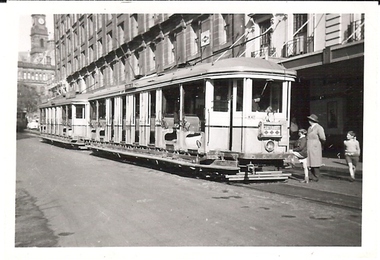
Photograph - BASIL MILLER COLLECTION: TRAM TO CANTERBURY
... Black and white photo of cross seat tram showing destination as Canterbury, man and 2 children standing near front of tram, clock tower in background. ...History House 11 Mackenzie Street Bendigo goldfields PERSON Individual basil miller Black and white photo of cross seat tram showing destination as Canterbury, man and 2 children standing near front of tram, clock tower in background. ...Black and white photo of cross seat tram showing destination as Canterbury, man and 2 children standing near front of tram, clock tower in background. 'LB Manny Collection Photo No 797' stamped on back, '(31)' written in blue ink on back of photo.person, individual, basil miller -
 Ringwood and District Historical Society
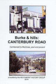
Book, Burke & Hills: Canterbury Road Camberwell to Montrose, by Heathmont History Group - 2014
... Canterbury, then on to Surrey Hills, Box Hill and Forest Hill. Further along past these three "hills" come three "monts" - Vermont, Heathmont and at its other end, Montrose, by then in the foothills of the Dandenongs. Grand homes and churches at one end, major and minor shopping centres along the 25km, factories now where farms were, big box stores, fast food outlets, train stations, resrvoir, traffic, residential stretches, modern apartment blocks, parklands, child-minding centres, sporting ovals, a sewage farm, hotels, quarries, commercial developments, plant nurseries, a golf course, bridges, memorials, Asian food shops, telecommunication towers, bushland, creeks, crossroads, traffic lights, mansions, orchards, swamps ... ...Canterbury, then on to Surrey Hills, Box Hill and Forest Hill. Further along past these three "hills" come three "monts" - Vermont, Heathmont and at its other end, Montrose, by then in the foothills of the Dandenongs. Grand homes and churches at one end, major and minor shopping centres along the 25km, factories now where farms were, big box stores, fast food outlets, train stations, resrvoir, traffic, residential stretches, modern apartment blocks, parklands, child-minding centres, sporting ovals, a sewage farm, hotels, quarries, commercial developments, plant nurseries, a golf course, bridges, memorials, Asian food shops, telecommunication towers, bushland, creeks, crossroads, traffic lights, mansions, orchards, swamps ... ...Soft cover book of 40 pages with spiral wire spine. Compilation of images and descriptive timeline of the geology, geography and European settlement history of Canterbury Road.Soon after beginning at Burke Road Camberwell, Canterbury Road moves into the gentle hills of Canterbury, then on to Surrey Hills, Box Hill and Forest Hill. Further along past these three "hills" come three "monts" - Vermont, Heathmont and at its other end, Montrose, by then in the foothills of the Dandenongs. Grand homes and churches at one end, major and minor shopping centres along the 25km, factories now where farms were, big box stores, fast food outlets, train stations, resrvoir, traffic, residential stretches, modern apartment blocks, parklands, child-minding centres, sporting ovals, a sewage farm, hotels, quarries, commercial developments, plant nurseries, a golf course, bridges, memorials, Asian food shops, telecommunication towers, bushland, creeks, crossroads, traffic lights, mansions, orchards, swamps ... Delaneys Road, renamed Canterbury Road after a 19th century Victorian Governor, is a fascinating study in land use and history as suburban Melbourne has continually diversified and pushed outwards. Compiled by Heathmont History Group, Rita James, Les Prato, Betty Colbert, Jeff Leipold, Gerry Robinson (convenor). -
 Canterbury History Group
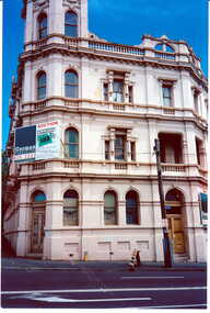
Photograph - Canterbury Road view of the Canterbury Mansions at No. 208 Canterbury Road, Jan Pigot, 1994
... Coloured photograph of the Canterbury Road view of the 3 storey Victorian Building called Canterbury Mansions. Also depicts the corner roof tower and the sold sign after the auction of the building....Canterbury Canterbury Road Shops Victorian Architecture Signs Coloured photograph of the Canterbury Road view of the 3 storey Victorian Building called Canterbury Mansions. Also depicts the corner roof tower and the sold sign after the auction of the building. ...Coloured photograph of the Canterbury Road view of the 3 storey Victorian Building called Canterbury Mansions. Also depicts the corner roof tower and the sold sign after the auction of the building.canterbury, canterbury road, shops, victorian architecture, signs -
Box Hill Historical Society
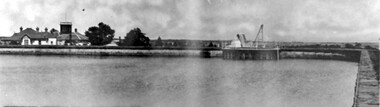
Photograph - Aerial view of the reservoir in Canterbury Road
... Canterbury Road. The photo is looking south over Surrey Hills and the telecommunication tower....Canterbury Road. The photo is looking south over Surrey Hills and the telecommunication tower. ...Aerial view of the reservoir in Canterbury Road. The photo is looking south over Surrey Hills and the telecommunication tower.aerial photographs, canterbury road, surrey hills, telecommunications equipment -
Box Hill Historical Society
Photograph - Water tower, Simon Fox, 1/12/1994
... towers...Buildings...Canterbury...This is a view of the water tower near the corner of Elgar Road and Canterbury Roads, Box Hill South....Water towers Buildings Canterbury Road Elgar Road Box Hill Photograph Water tower Simon Fox ...This is a view of the water tower near the corner of Elgar Road and Canterbury Roads, Box Hill South.water towers, buildings, canterbury road, elgar road, box hill -
 Surrey Hills Historical Society Collection
Book, Raheen: a house and its people, 2007
... Canterbury melbourne Raheen is a 120 year old Victorian house owned by Richard and Jeanne Pratt. Mrs Jeanne Pratt commissioned the book and this copy was presented to Sue Barnett on a visit by members of the Boroondara Historical Societies. The visit was organised by local member Mr Josh Frydenburg. 92p. ill. bibliog., Raheen was a grand two-storey red brick house in the Italianate Style, with a prominent tower and an arcaded loggia on two levels. ...Raheen is a 120 year old Victorian house owned by Richard and Jeanne Pratt. Mrs Jeanne Pratt commissioned the book and this copy was presented to Sue Barnett on a visit by members of the Boroondara Historical Societies. The visit was organised by local member Mr Josh Frydenburg. 92p. ill. bibliog., Raheen was a grand two-storey red brick house in the Italianate Style, with a prominent tower and an arcaded loggia on two levels. This book explores its history, restoration and further development over many years. 92p. ill. bibliog., Raheen was a grand two-storey red brick house in the Italianate Style, with a prominent tower and an arcaded loggia on two levels. This book explores its history, restoration and further development over many years.Endpaper: Surrey Hills Historical Society / Jeanne Pratt / 27/7/2013(mr) ian allen oam, (mr) william lawrence bailieu, ehud barak, (dr) james broadbent, (mr) robert bruce, (mr) george h w bush, (mrs) barbara pierce bush, (mr) arthur calwell, (ms) jane dennithorne, (mr) eamon de valera, (sir) james augustine gobbo, (mr) lloyd hill, (mr) william morris hughes, (lord) (mr) immanuel jakobovits, (mr) philip johnson, (cardinal) (mr) walter kaspar, moshe katsav, (mr) james robert knox, (mr) terence lane, (mr) edward latham, (mr) michael lehany, (dr) (mr) miles lewis, (mr) sam lipski am, (sir) (mr) thomas francis little, (mr) peter lovell, (mr) egidio lunardon, (mr) (cardinal) jean-marie lustiger, (mr) daniel patrick mannix, (sir) (mr) robert gordon menzies, (mr) henry miller, (mr) glen murcutt ao, (mr) benjamin netanyahu, (mr) ngo dinh diem, (mr) phillip nikolitsis, i (eoh) m(eng) pei, (mr) shimon peres, (mr) joseph reed, (mr) yves st laurent, (mr) william salway, (mr) james henry scullin, jessie serle, (mr) justin david simonds, (mrs) heliose waislitz, (miss) heliose pratt, (mr) john wren, (sir) (mr) henry john wrixon, (mr) richard pratt, (mrs) jeanne pratt, raheen, historical buildings, kew, victoria, italianate style, house names -
 Surrey Hills Historical Society Collection
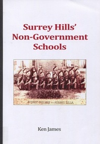
Book, Surrey Hills' Non-Government Schools, 2016
... Surrey Hills Historical Society Collection 190A Canterbury Road Canterbury melbourne Provides background and history of the fifteen non-government (independant) schools in Surrey Hills schools - boroondara st joseph's home and residential school campden ladies college surrey college hessle school ormiston college ladies high school (jessie tait) surrey hills preparatory grammar school surrey hills kindergarten and preparatory school tower house school craighall milverton ladies college our holy redeemer school our lady's primary school st andrew's presbyterian school miss mccleverty's girls high school (Mr) Ken james st brigids jessie tait Provides background and history of the fifteen non-government (independant) schools in Surrey Hills 124p Surrey Hills' Non-Government Schools Book Book Ken James ...Provides background and history of the fifteen non-government (independant) schools in Surrey HillsProvides background and history of the fifteen non-government (independant) schools in Surrey Hills 124pschools - boroondara, st joseph's home and residential school, campden ladies college, surrey college, hessle school, ormiston college, ladies high school (jessie tait), surrey hills preparatory grammar school, surrey hills kindergarten and preparatory school, tower house school, craighall, milverton ladies college, our holy redeemer school, our lady's primary school, st andrew's presbyterian school, miss mccleverty's girls high school, (mr) ken james, st brigids, jessie tait -
 Surrey Hills Historical Society Collection
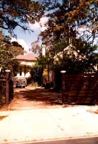
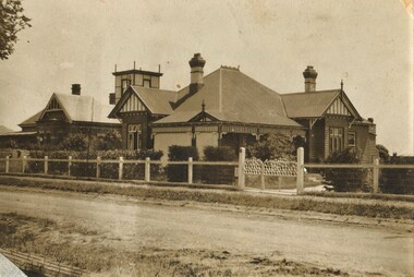
Photograph, Rear of Varndean from Willcyrus Street, 1988, 1988
... Canterbury melbourne Ref: Alan Holt records - This property has had a number of different names throughout its history. William Cook, a farmer, bought the land it stands on in 1876. In 1882 he was rated for a house (not the current one) on 11 acres. The present house was built in 1885 by John Clark, an auctioneer. In 1888 the Tower ...Ref: Alan Holt records - This property has had a number of different names throughout its history. William Cook, a farmer, bought the land it stands on in 1876. In 1882 he was rated for a house (not the current one) on 11 acres. The present house was built in 1885 by John Clark, an auctioneer. In 1888 the Tower Hill estate and the home (Tower Hill Lodge) were auctioned, but the house was not sold. In 1889 the house was purchased by Captain Shepherd. Records show that in 1894 the owners were Mr Thomas and Mrs Hortenzia Howell. They named the house 'Corcovado'. Later they added a study with a corner designed to provide views from the Dandenong Ranges around to Mt Macedon. In 1944 Mr and Mrs Lionel Adams renamed the house 'Varndean'.This is one of the earliest surviving houses in Surrey Hills.A colour photo taken from the street at the rear of a Victorian-style house with ornate chimneys and a slate roof. A parked car is seen in front of the house. The house sits behind a timber fence and is partly hidden by mature shrubs and trees.victorian style, tower hill lodge, corcovado, varndean, tower hill estate, mr william cook, mr john clark, mrs hortenzia howell, mr lionel adams, mrs lionel adams, surrey hills, captain louis shepherd, mr thomas howell -
 Surrey Hills Historical Society Collection
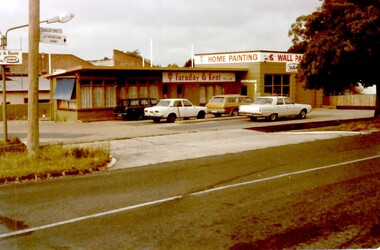
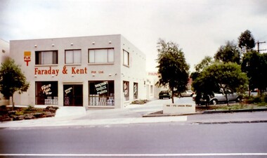
Photograph, Faraday & Kent, 172 Union Road Surrey Hills, 1979
... Surrey Hills Historical Society Collection 190A Canterbury Road Canterbury melbourne This site was previously occupied by a Golden Fleece petrol station and later by Cobb & CO car rental. In Paul Towers ...This site was previously occupied by a Golden Fleece petrol station and later by Cobb & CO car rental. In Paul Towers bought the property from Faraday & Kent, for whom Norm Henderson was the proprietor, in 1996. In 2003 it was bought by Evan Lewis. (NOTE re source: undated note re verbal history given by un-named person).A colour photograph of the corner of Guildford Road and Union Road. There are four cars parked in front of a building. There is a sign identifying Faraday & Kent - home painting and wallpaper.guildford road, surrey hills, faraday & kent, businesses, paint shop, union road, norman henderson, evan lewis, paul towers, norm henderson -
 Surrey Hills Historical Society Collection
Photograph, Surrey Hills looking south-east from the steeple of Holy Trinity Church, 1921, 1921
... The photographer Norman Carter took many photos of Surrey Hills and Mont Albert from the 1920s, in particular of events and activities associated with the Church of England. albany crescent windsor crescent st stephens presbyterian church surrey hills primary school railways stationmasters' houses bedford avenue norman carter edgeware dr percy liddle dr james blakie On back of original: "6-11-21" and in a different hand in biro: "from tower of Holy Trinity Church" Black and white photo taken from the steeple of Holy Trinity Church looking across housing towards the railway line and Albany / Windsor Crescents and on towards Canterbury Road. ...The property in the foreground is 'Edgeware' at 171 Union Road, a house built by the Zeplin family. It became the home / residence of Dr Percy Liddle and later Dr James Landells Blakie. By the time this photo was taken Dr Blakie had moved across the road to 174 Union Road. In the background behind the 2 houses in the foreground is the Surrey Hills Stationmaster's house, sitting behind a picket fence. The Alan Holt register gives a build date of c1915 for this house, which fits stylistically. The first stationmaster was probably Michael Ginnane, who stayed in the area after he retired, moving to 1 Russell Street. This property was listed as 8 Bedford Avenue, the only house on the south side of the road. It was demolished in c1972 to make way for widening of the rail track with a third line. The photographer Norman Carter took many photos of Surrey Hills and Mont Albert from the 1920s, in particular of events and activities associated with the Church of England.Black and white photo taken from the steeple of Holy Trinity Church looking across housing towards the railway line and Albany / Windsor Crescents and on towards Canterbury Road. Surrey Hills Primary School and St Stephens Presbyterian Church feature prominently on the horizon. The stationmaster's cottage is centre left adjacent to a large conifer-like tree, with a white fence delineating the railway yards.On back of original: "6-11-21" and in a different hand in biro: "from tower of Holy Trinity Church"albany crescent, windsor crescent, st stephens presbyterian church, surrey hills primary school, railways, stationmasters' houses, bedford avenue, norman carter, edgeware, dr percy liddle, dr james blakie -
 Surrey Hills Historical Society Collection
Photograph, Union Road looking west from the steeple of Holy Trinity Church, 1922, 1922
... Canterbury melbourne At the edge of the church roof and on the horizon is 'The Knoll' on the corner of Union Road and Wandsworth Road. To the left of this is 297 Mont Albert Road, home of the Michael Parer family and further left is "Quamby", home of the Sherar family. This is easily recognised by the square viewing tower ...At the edge of the church roof and on the horizon is 'The Knoll' on the corner of Union Road and Wandsworth Road. To the left of this is 297 Mont Albert Road, home of the Michael Parer family and further left is "Quamby", home of the Sherar family. This is easily recognised by the square viewing tower located on the west wing of the house. The Sherar family owned 'Quamby' from 1900 until 1925, when it became Mosgiel Private Hospital. Norman Carter took many photos of Surrey Hills and Mont Albert in the 1920s; many associated with events and activities of the Church of England. Black and white photo of taken from the steeple of Holy Trinity Church, during its construction, across Union Road to the north-west. In the foreground immature street trees can be seen and an original telephone pole with white insulators. The street has formed paths and bluestone kerb and channelling. holy trinity anglican church, union road, the knoll, quamby, street trees, telegraph and light poles, mosgiel hospital -
 Surrey Hills Historical Society Collection
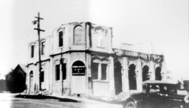
Photograph, Demolition of Tower House Day and Boarding School, Surrey Hills in 1932 (1)
... Rear top centre in blue biro "1932" (crossed out); top RH corner "498" in red biro; centre "Demolition of / Tower House Day & Boarding / cr Canterbury & Broughton Rds / previously Tower House Hotel / originally Royal Hotel / See partner photo...Norman Carter took many photos of Surrey Hills and Mont Albert from the 1920s; many were associated with events and activities of the Church of England. tower house day and boarding school schools education royal hotel hotels construction and demolition dry area licensing polls temperance movement delany's hotel norman carter Rear top centre in blue biro "1932" (crossed out); top RH corner "498" in red biro; centre "Demolition of / Tower House Day & Boarding / cr Canterbury & Broughton Rds / previously Tower House Hotel / originally Royal Hotel / See partner photo ...This building dated back to the 1880s and had previously operated as Delany's Hotel and then the Royal Hotel. It was built near the site of the original Delany's Hotel, built in 1856. The Royal Hotel closed in 1921 after the area voted to be a 'dry area' in the local option poll. Tower House Day and Boarding School operated from 1921 until 1932. Norman Carter took many photos of Surrey Hills and Mont Albert from the 1920s; many were associated with events and activities of the Church of England.Black and white photo of a partially demolished building. The roof and part of the second storey are missing. What remains indicates that it has been a large building in the Victorian style. Along one side at ground level there are 4 arches, perhaps entry to a covered veranda, above which is a colonnade, and perhaps an open veranda on the upper level. There is a mixture of treatments to the surrounds of the windows. On the corner, within an arch which may have once been a doorway, is a sign reading: "TOWER HOUSE / DAY / & / BOARDING SCHOOL". There is a car with a retractable hood in the lower RH Corner of the photo.Rear top centre in blue biro "1932" (crossed out); top RH corner "498" in red biro; centre "Demolition of / Tower House Day & Boarding / cr Canterbury & Broughton Rds / previously Tower House Hotel / originally Royal Hotel / See partner photo."; bottom RH cnr "demol (in red biro) / 20-8-32". All in Jocelyn Hall's handwriting.tower house day and boarding school, schools, education, royal hotel, hotels, construction and demolition, dry area, licensing polls, temperance movement, delany's hotel, norman carter -
 Surrey Hills Historical Society Collection
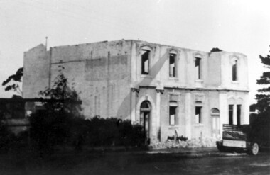
Photograph, Demolition of Tower House Day and Boarding School, Surrey Hills in 1932 (2), 20/08/1932
... Surrey Hills Historical Society Collection 190A Canterbury Road Canterbury melbourne This building dated back to the 1880s and had previously operated as Delany's Hotel and then the Royal Hotel. It was built near the site of the original Delany's Hotel, built in 1856. The Royal Hotel closed in 1921 after the area voted to be a 'dry area'. Tower ...This building dated back to the 1880s and had previously operated as Delany's Hotel and then the Royal Hotel. It was built near the site of the original Delany's Hotel, built in 1856. The Royal Hotel closed in 1921 after the area voted to be a 'dry area'. Tower House Day and Boarding School operated from 1921 until 1932. Norman Carter took many photos of Surrey Hills and Mont Albert from the 1920s; many were associated with events and activities of the Church of England.Black and white photo of a partially demolished building. The roof is missing and there is a pile of rubble along the front wall. What remains indicates that it has been a large building in the Victorian style. There is a mixture of treatments to the surrounds of the windows. On the RHS part of a truck can be seen.Original: Top LH corner in blue biro "see matching photo"; top RH corner "498 / spare"; bottom LH corner in lead pencil "N Carter"; bottom RH corner in blue biro "20-8-32" - all Jocelyn Hall's handwriting.tower house day and boarding school, schools, education, royal hotel, hotels, construction and demolition, dry area, licensing polls, temperance movement, delany's hotel, norman carter -
 Surrey Hills Historical Society Collection
Photograph, Faraday & Kent, 172 Union Road, Surrey Hills, 1983
... Surrey Hills Historical Society Collection 190A Canterbury Road Canterbury melbourne Prior to Faraday and Kent establishing a paint retail business of this site, there was a car hire business called Cobb & Co and prior to this the site was a Golden Fleece Service Station. Paul Towers ...Prior to Faraday and Kent establishing a paint retail business of this site, there was a car hire business called Cobb & Co and prior to this the site was a Golden Fleece Service Station. Paul Towers bought the property from Faraday & Kent, for whom Norm Henderson was the proprietor, in 1996. In 2003 it was bought by Evan Lewis. (NOTE re source: undated note re verbal history given by un-named person).A colour photograph of a two storey building with Faraday & Kent Pty Ltd on the front of the building. A small brick fence has an address on it identifying it as 168-172 Union Road. There are cars parked to the right of the photo and a number of trees.guildford road, surrey hills, faraday & kent, businesses, cars, 1983, paint shop, 1993, cobb & co, 1978, union road, mr norman henderson, car hire, evan lewis, paul towers -
Surrey Hills Historical Society Collection
Folder of real estate advertisements, Folders of real estate advertisements (Streets beginning with T), Various
... Surrey Hills Historical Society Collection 190A Canterbury Road Canterbury melbourne tevelton lane thames street the avenue theodore street thistle street thornton avenue tower street trafalgar street tyndall street A4 folders with individual pockets for each property in streets beginning with T located in Surrey Hills and Mont Albert. ...A4 folders with individual pockets for each property in streets beginning with T located in Surrey Hills and Mont Albert. Folders are ordered by street name and then chronologically by property number. Each property has its own pocket. This may include multiple real estate advertisements collected from sales over time. It may also include copies of any research undertaken by Alan Holt and / or members of the SHNCHC team. These are augmented by cards in the Alan Holt index file and by his property registers of Surrey Hills and Mont Albert.tevelton lane, thames street, the avenue, theodore street, thistle street, thornton avenue, tower street, trafalgar street, tyndall street -
 Surrey Hills Historical Society Collection
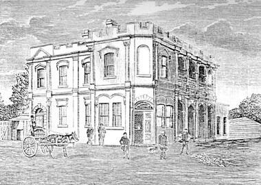
Photograph, Humberstone's Royal Hotel Surrey Hills
... Canterbury Road...Broughton Road...hotels...accommodation...Royal Hotel...Tower...Canterbury and Broughton Road. The hotel was built in 1887 to replace an older hotel (Delany's Hotel) built further east in 1856. It was de-licensed in 1921 after a "Local Option Poll" and became Tower House Day & Boarding School under Miss Marion Beetson from 1922 until 1932. ...Canterbury and Broughton Road. The hotel was built in 1887 to replace an older hotel (Delany's Hotel) built further east in 1856. It was de-licensed in 1921 after a "Local Option Poll" and became Tower House Day & Boarding School under Miss Marion Beetson from 1922 until 1932. ...Humberstone's Royal Hotel was a substantial 2-storey building on the corner of Canterbury and Broughton Road. The hotel was built in 1887 to replace an older hotel (Delany's Hotel) built further east in 1856. It was de-licensed in 1921 after a "Local Option Poll" and became Tower House Day & Boarding School under Miss Marion Beetson from 1922 until 1932. It was demolished in 1932. There were 25 students in the 1920's, mostly boarders from outside Surrey Hills and all primary school students. The school room was detached from the main building and there was 6 acres of playing area. The old bar was the business office, the girls' dormitory the old dining room. Marion Beetson was the teacher, Mary Beetson managed the household. Their father was an Indian Army officer. The younger children wore a school blazer with the T.H.C. badge on the pocket. Miss Susan Kelsall visited to give piano lessons and Prof. Kelsall taught French. Miss Marion Beetson died in Castlemaine on 8 February 1952. Information courtesy of Mrs Louise Bell, Castlemaine, ex-student. See SHP0867a and SHP0867b, photos of Louisa in T.H.C. uniform. Photograph of line sketch of Humberstone's Royal Hotel, Surrey Hills. In the foreground is a horse and cart with 5 men standing in front of the hotel. Main entrance is on the corner of the intersection with large windows. There are 8 on one side and 3 on the other with 4 arches on both upper and ground floors. Turret style edging hides the rooftop with two chimneys visible. Pencilled on back "Spare - have in/ our photo files"delany's hotel, miss marion beetson, humberstone's royalhotel, surrey hills, canterbury road, broughton road, hotels, accommodation, royal hotel, tower house day and boarding school, 1880-1890, mary beetson -
Surrey Hills Historical Society Collection
Map, Contour map of Surrey Hills showing potential sites for the Telecom Tower
... Surrey Hills Historical Society Collection 190A Canterbury Road Canterbury melbourne The PMG / Telecom / Telstra tower was built in 1961-1963 as a relay station to support television and radio links between city and regional broadcasting stations. ...The PMG / Telecom / Telstra tower was built in 1961-1963 as a relay station to support television and radio links between city and regional broadcasting stations. The tower itself was 45 m in height with a 2 storey building for equipment and staff surrounded by garden. From the beginning it was opposed by local residents. The location is said to be the second highest site in Melbourne, sometimes described as Delaney's Hill.Two A3 photocopied sheets of a map showing part of Surrey Hills, roughly between Windsor Crescent and Belmont Street (north / south) and Standard Avenue and Balmoral Crescent (east / west). The map shows contour lines and house sites, 16 of which are numbered. One sheet has been inscribed in top RH corner with notes regarding the significance of the numbers."Contour map of potential sites / for the telecommunications tower which / was eventually sited at 2. / Jock Campbell OBE was our neighbour / at 4 Theodore St when we moved into / the area in 1984. He was responsible in his / job at the PMG in deciding on the /site of the tower - Note site 5 was / behind his (& our) house. / Jack ended his career as Deputy Director / of the PMG. He sat on international committees / after WW2 to decide the split of the electronic / spectrum for radio, TV etc. / His group developed a "mobile phone" using / fixed towers but the phone was a truck full of gear."contour map, telecom tower, maps, jock campbell, john duncan campbell -
Surrey Hills Historical Society Collection
Work on paper - Vertical file on Back Creek, Surrey Hills
... It rises as a spring on the slopes of the hill at the corner of Canterbury Road and Elgar Road in Surrey Hills, the location of a Melbourne Water tower and reservoir. ...It rises as a spring on the slopes of the hill at the corner of Canterbury Road and Elgar Road in Surrey Hills, the location of a Melbourne Water tower and reservoir. ...Back Creek is one of the tributaries of Gardiners Creek. It rises as a spring on the slopes of the hill at the corner of Canterbury Road and Elgar Road in Surrey Hills, the location of a Melbourne Water tower and reservoir. It has been channelled underground from this point in pipes as far as Union Road. South Surrey Park runs along both sides of Back Creek from where the creek crosses Union Rd near Rose Avenue to where it crosses Riversdale Road just west of Through Road. A vertical file containing information about Back Creek in Surrey Hills: 1. 4 colour photos taken in 1983 (1 page). 2. ‘Pipe dreams run their course’, (Boroondara Review ?) 17.4.2013 (1 page). 3. ‘Plan rainchecked for creek impact’, Boroondara Review, 13.3.2013 (2 pages). back creek -
 Surrey Hills Historical Society Collection
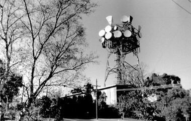
Photo, Telecom tower, Canterbury Road
... Telecom tower, Canterbury Road...tower...telstra...telecom...harding street...canterbury...Telecom tower, Canterbury Road Photo ...This photo of the Telecom Tower was one of a series of photos taken of landmarks and houses of the area by Ken Hall in c1980. The PMG / Telecom / Telstra tower was built in 1961-1963 as a relay station to support television and radio links between city and regional broadcasting stations. The tower itself was 45 m in height with a 2 storey building for equipment and staff surrounded by garden. From the beginning it was opposed by local residents. In response to a Telstra application to replace it with a 40m slimline monopole, the City of Whitehorse controversially sought to have the structure heritage-listed, a move which caused much debate. In May 2015 Council ultimately rescinded its decision and gave permission for demolition, however Telstra deemed the permit conditions to be too restrictive and decided to continue to use the tower. The permit (to replace the tower) expired in September 2017. A black and white photo of local landmark visible from many vantage points in Surrey Hills and surrounding area, as it was built on the high point of the area.telecommunications tower, city of whitehorse, heritage overlay, heritage study, development, pmg tower, telstra, telecom, harding street, canterbury road -
 Surrey Hills Historical Society Collection
Photograph, 10 Pembroke Street, Surrey Hills
... Canterbury melbourne ‘Eignbrook’ at 10 Pembroke Street was built 1904. Until the 1950s this area was the highest spot in the metropolitan area and ships in the Bay could be seen from ground level and views extended almost 360 degrees. A number of homes of this Edwardian period had viewing towers ...‘Eignbrook’ at 10 Pembroke Street was built 1904. Until the 1950s this area was the highest spot in the metropolitan area and ships in the Bay could be seen from ground level and views extended almost 360 degrees. A number of homes of this Edwardian period had viewing towers, the one in the photo being that of ‘Maroondah’ at 12 Pembroke Street. Photo taken by W V Hill. Courtesy: Mr William (Bill) Dempsey. Original sepia photograph of a weatherboard home in the Queen Anne style. It has a steep pitched iron roof. It has a woven wire fence across the front of the property and decorative gates. Mounted on white cardboard photo taped on 2 corners.Back of photo is inscribed “Hills, 10 Pembroke St, Surrey Hills”. Card has written underneath the photo, “10 Pembroke St, Home of Hills family, built 1904”pembroke street, house names, surrey hills, hills family, 'maroondah', 'eignbrook', (mr) w v hill, (mr) william (bill) dempsey, journalist, queen anne style, (mrs) annie hill -
 Surrey Hills Historical Society Collection
Photograph, Surrey Hills Reservoir No 1
... ...canterbury road...tower...Tower Street built in c1892 at a cost of £12,000 to supply higher sections of the area. The builders were Jack and Bob Laudehr, partners in a wood yard in St. Kilda (Vic). They began by delivering firewood but extended to contract work involving timber. Another of their projects was to lay cable tram tracks commencing in Acland Street St. Kilda and running along The Esplanade. The reservoir in Canterbury...Canterbury Rd / Surrey Hills." On the rear in grey lead pencil in Jocelyn Hall's handwriting: "Donor W Dempsey ------------- Keep / (nephew) / [arrow pointing down] / From Miss Hill / 10 Pembroke St SH / This house can be / seen in front of / No 12 which has / tower"...Bill Dempsey's mother was Laura Constance 'Birdie' Hill (1900-1968) who married Albert Dempsey. 1890 water supply mmbw edward d dyer (mr) 10 pembroke street 12 pembroke street surrey hills ivy annie hill (miss) william valentine hill (mr) canterbury road tower street water supply structures and establishments dams and reservoirs jack laudehr (mr) bob laudehr (mr) Below the photo on the front of the postcard on blue biro "Reservor [sic] Canterbury Rd / Surrey Hills." ...Copied by Ken Hall from an early postcard. This is Surrey Hills Reservoir No 1 on the corner of Tower Street built in c1892 at a cost of £12,000 to supply higher sections of the area. The builders were Jack and Bob Laudehr, partners in a wood yard in St. Kilda (Vic). They began by delivering firewood but extended to contract work involving timber. Another of their projects was to lay cable tram tracks commencing in Acland Street St. Kilda and running along The Esplanade. The reservoir in Canterbury Road was a large concrete structure built before the introduction of reinforcements. The excavated material was banked against the sides and pine trees were planted in it to add strength to the embankment. They were paid £2,000 for their work. Construction of Surrey Hills Number 2 Reservoir was completed in 1913 and the accompanying tower was built in 1929. It is assumed that the Miss Hill as the source of the donation (via Bill Dempsey) was Ivy Annie Hill (1902-1984). She was the only female child of William Valentine Dempsey to not marry. Bill Dempsey's mother was Laura Constance 'Birdie' Hill (1900-1968) who married Albert Dempsey.A sepia photograph within a post card of a reservoir on Canterbury Road, Surrey Hills. In the background to the left you can see the top halves of two houses and the tops of some trees. The photo takes up only the central section of the postcard.Below the photo on the front of the postcard on blue biro "Reservor [sic] Canterbury Rd / Surrey Hills." On the rear in grey lead pencil in Jocelyn Hall's handwriting: "Donor W Dempsey ------------- Keep / (nephew) / [arrow pointing down] / From Miss Hill / 10 Pembroke St SH / This house can be / seen in front of / No 12 which has / tower"1890, water supply, mmbw, edward d dyer (mr), 10 pembroke street, 12 pembroke street, surrey hills, ivy annie hill (miss), william valentine hill (mr), canterbury road, tower street, water supply structures and establishments, dams and reservoirs, jack laudehr (mr), bob laudehr (mr) -
 Surrey Hills Historical Society Collection
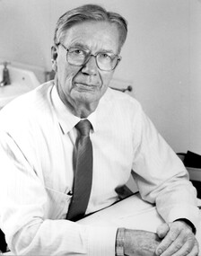
Photograph, Dr George Doery
... George Edward Doery (was one of 3 children of William Henry Doery and wife Theodora M Bartholomew who were married in 1914 and resided from this time until c1963 at 16 Tower Street, Surrey Hills. The Doery family were stalwarts of the Canterbury Baptist Church. ...Surrey Hills Historical Society Collection 190A Canterbury Road Canterbury melbourne George Edward Doery (was one of 3 children of William Henry Doery and wife Theodora M Bartholomew who were married in 1914 and resided from this time until c1963 at 16 Tower Street, Surrey Hills. ...George Edward Doery (was one of 3 children of William Henry Doery and wife Theodora M Bartholomew who were married in 1914 and resided from this time until c1963 at 16 Tower Street, Surrey Hills. The Doery family were stalwarts of the Canterbury Baptist Church. George graduated MBBS from the University of Melbourne in 1949. He married Mary Elizabeth Weller (1922-2004) in 1950. He joined the Mont Albert medical Group and practised there until his retirement, The photo was taken to mark his retirement and appeared in a local newspaper. He died 21/9/2011. A black and white photograph of a man sitting at a desk. He is wearing a shirt and tie and a pair of glasses.george doery (dr), george edward doery (dr), medical practitioners, doctors, mont albert medical group, mary doery (mrs), mary elizabeth doery (mrs), mary weller (miss), mary elizabeth weller (miss), canterbury baptist church -
 Surrey Hills Historical Society Collection
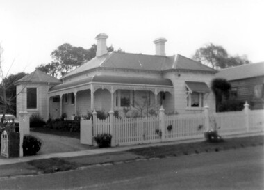
Photograph, 'Garmure', 26 Russell Street, Surrey Hills in 1988
... Surrey Hills Historical Society Collection 190A Canterbury Road Canterbury melbourne ‘Garmure’, 26 Russell Street, Surrey Hills was built c. 1887 and renovated c1988. This photo was taken after renovation of the rear of the house when the corner tower was added. ...‘Garmure’, 26 Russell Street, Surrey Hills was built c. 1887 and renovated c1988. This photo was taken after renovation of the rear of the house when the corner tower was added. Occupants: 1890: Mr Caffin 1910: Miss Agnes Campbell Hutchinson Orr 1930 – 1988: Sextons Miss Orr was born in Hutchesontown, Glasgow to Francis Orr (1834-1859) and Jane McDonald. Her father died soon after her birth and her mother married Thomas Blood. She had a half-brother Robert McDonald Blood. In 1903 she, her brother and mother were living in Boundary Road. She is buried with them in Kew Cemetery. She died aged 57 on 1 December 1926. A black and white photograph of a Queen Anne Style weatherboard house with a return veranda. The roof is corrugated iron. There is a picket fence along the front and a driveway on the left had side of the building.garmure, house names, (mr) - caffin, sexton family, queen anne style, corrugated iron, weatherboard, russell street, surrey hills, (miss) agnes campbell hutchinson orr