Showing 229 items matching " county of bourke"
-
 Sunshine and District Historical Society Incorporated
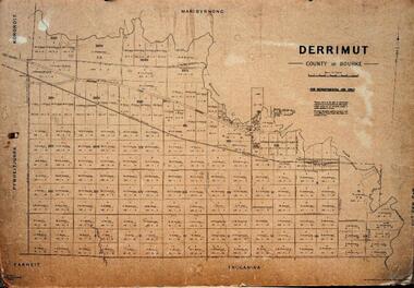
Map - Derrimut, County of Bourke Map, Department of Lands and Survey, circa 1950s
... Derrimut, County of Bourke Map...... County of Bourke...Plan of Parish of Derrimut, County of Bourke, circa late 1950s. Mounted on thick card...."Derrimut, County of Bourke" "For Departmental use only" "By Authority Gourley Government Printer"...Derrimut County of Bourke Map "Derrimut, County of Bourke" "For Departmental use only" "By Authority Gourley Government Printer" Plan of Parish of Derrimut, County of Bourke, circa late 1950s. ..."Derrimut, County of Bourke" "For Departmental use only" "By Authority Gourley Government Printer"derrimut, county of bourke, map -
 Sunshine and District Historical Society Incorporated
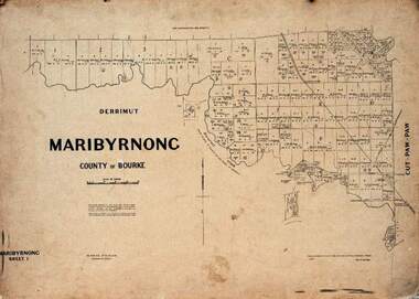
Map - Maribyrnong, County of Bourke Map, Department of Lands and Survey, 1957
... Maribyrnong, County of Bourke Map...... County of Bourke..."Maribyrnong, County of Bourke"...Maribyrnong County of Bourke Map "Maribyrnong, County of Bourke" Plan of Parish of Maribyrnong, Sheet 1 , 1957 on thick card. ..."Maribyrnong, County of Bourke"maribyrnong, county of bourke, map -
 Sunshine and District Historical Society Incorporated
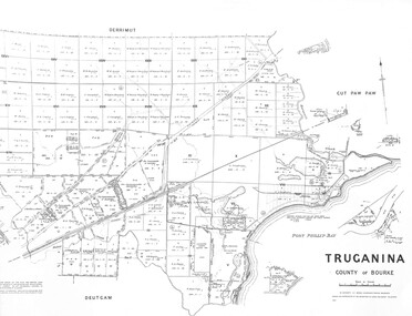
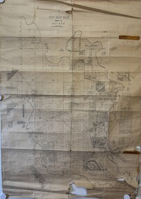
Map - Truganina County of Bourke 1959 Map, Department of Lands and Survey Malbourne, 1959
... Truganina County of Bourke 1959 Map...Map Truganina County of Bourke 1959 Map...Truganina County of Bourke 1959 Map...Truganina Map Truganina County of Bourke 1959 Map Map Truganina County of Bourke 1959 Map Map Truganina County of Bourke 1959 Map Department of Lands and Survey Malbourne ...Truganina County of Bourke 1959 Maptruganina, map -
 Sunshine and District Historical Society Incorporated
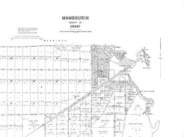
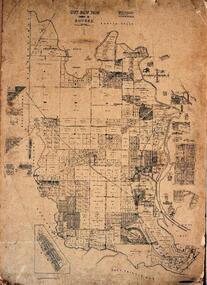
Map - Mambourin County of Bourke 1958 Map, Department of Lands and Survey Malbourne, 1958
... Mambourin County of Bourke 1958 Map...Map Mambourin County of Bourke 1958 Map...Mambourin County of Bourke 1958 Map|Township Of Werribee|Black Forest...Mambourin Mambourin County of Bourke 1958 Map|Township Of Werribee|Black Forest Map Mambourin County of Bourke 1958 Map Map Mambourin County of Bourke 1958 Map Department of Lands and Survey Malbourne ...Mambourin County of Bourke 1958 Map|Township Of Werribee|Black Forestmambourin -
 Sunshine and District Historical Society Incorporated
Map - Parish Of Cut Paw Paw County of Bourke Map, 30th October 1930
... Parish Of Cut Paw Paw County of Bourke Map...Cut Paw Paw County of Bourke Map...Parish Of Cut Paw Paw County of Bourke Map...Cut Paw Paw County of Bourke Map Parish Of Cut Paw Paw County of Bourke Map Large map of the Parish Of Cut Paw Paw County Map Parish Of Cut Paw Paw County of Bourke Map ...Parish Of Cut Paw Paw County of Bourke Mapcut paw paw county of bourke map -
 Sunshine and District Historical Society Incorporated
Map - Cut Paw Paw, County of Bourke Map, Department of Lands and Survey, 1952
... Cut Paw Paw, County of Bourke Map...... County of Bourke...Plan of Parish of Cut Paw Paw, County of Bourke, 1952. Mounted on thick card....Price 2-" Plan of Parish of Cut Paw Paw, County of Bourke, 1952. Mounted on thick card. Map Cut Paw Paw, County of Bourke Map Department of Lands and Survey ..."Drawn and reproduced by Dept of Lands and Survey, Melbourne, Victoria, July 1952. Price 2-"cut paw paw, county of bourke, map -
 Sunshine and District Historical Society Incorporated
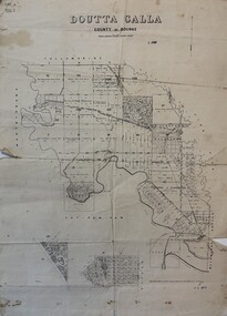
Map - Doutta Galla County of Bourke Map 8th February 1878, Department of Lands and Survey Melbourne by T. F. McGouran, 8th February 1878
... Doutta Galla County of Bourke Map 8th February 1878...Map map showing the allotments of the Doutta Galla County of Bourke includes North Braybrook...Doutta Galla County of Bourke Map 8th February 1878...Map Doutta Galla County of Bourke Map 8th February 1878 Map map showing the allotments of the Doutta Galla County of Bourke includes North Braybrook Map Doutta Galla County of Bourke Map 8th February 1878 Department of Lands and Survey Melbourne by T. ...Doutta Galla County of Bourke Map 8th February 1878map -
 Sunshine and District Historical Society Incorporated
Map - Derrimut County of Bourke, Department of Lands and Survey, 1945
... Derrimut County of Bourke...Plan of Parish of Derrimut, County of Bourke, circa late 1950s. Mounted on thick card....Derrimut, County of Bourke For Departmental use only By Authority Gourley Government Printer...Derrimut Map Derrimut, County of Bourke For Departmental use only By Authority Gourley Government Printer Plan of Parish of Derrimut, County of Bourke, circa late 1950s. ...Derrimut, County of Bourke For Departmental use only By Authority Gourley Government Printerderrimut, map -
 Sunshine and District Historical Society Incorporated
Map - Maribyrnong, County of Bourke, Department of Lands and Survey, 1957
... Maribyrnong, County of Bourke... County of Bourke...Map of Maribyrnong, County of Bourke (block owners) Sheet 1. Prepared by Department of Lands and Survey. ...County of Bourke Map Maribyrnong Map of Maribyrnong, County of Bourke (block owners) Sheet 1. ...county of bourke, map, maribyrnong -
Sunshine and District Historical Society Incorporated
Map - Maribyrnong, County of Bourke, Department of Lands and Survey, 1957
... Maribyrnong, County of Bourke... County of Bourke...Map of Maribyrnong, County of Bourke (block owners) Sheet 2. Prepared by Department of Lands and Survey. ...County of Bourke Map Maribyrnong Map of Maribyrnong, County of Bourke (block owners) Sheet 2. ...county of bourke, map, maribyrnong -
Sunshine and District Historical Society Incorporated
Map - Map of Derrimut, County of Bourke, Department of Lands and Survey, no date
... Map of Derrimut, County of Bourke...... County of Bourke...Map of Derrimut, County of Bourke (block owners) Sheet 2. Prepared by Deptment of Lands and Survey. ...Derrimut County of Bourke Map Map of Derrimut, County of Bourke (block owners) Sheet 2. ...derrimut, county of bourke, map -
Whitehorse Historical Society Inc.
Map, Directory Maps of the County of Bourke, 1892
... Directory Maps of the County of Bourke......Victoria. County of Bourke...Directory maps of the County of Bourke, containing all the Parishes ... also a complete map of the Colony of Victoria, showing all the Counties, Parishes, Railways and stations to date, and the Mallee Blocks. ...Maps Victoria. County of Bourke T.R.B. Morton & Son Directory maps of the County of Bourke, containing all the Parishes ... ...Directory maps of the County of Bourke, containing all the Parishes ...Directory maps of the County of Bourke, containing all the Parishes ... also a complete map of the Colony of Victoria, showing all the Counties, Parishes, Railways and stations to date, and the Mallee Blocks. Lithographed by G.S.B. Bonney for the Victorian Shire Map Company. Scale: 40 chains to the inch.Directory maps of the County of Bourke, containing all the Parishes ...maps, victoria. county of bourke, t.r.b. morton & son -
Port Melbourne Historical & Preservation Society
Map - County of Bourke, Thomas Bibbs, 1866
... County of Bourke...Map of the County of Bourke, 1886...Port Melbourne Historical & Preservation Society Port Melbourne Town Hall 333 Bay Street Port Melbourne melbourne Melbourne Map of the County of Bourke, 1886 Map County of Bourke Thomas Bibbs William Collis ...Map of the County of Bourke, 1886melbourne -
 Bacchus Marsh & District Historical Society
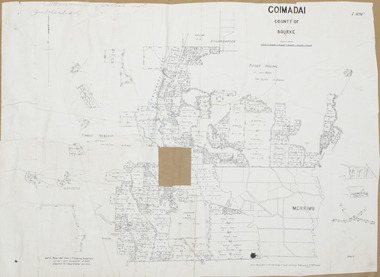
Map, Coimadai Parish Map, County of Bourke. Circa 1890s-1900s
... Coimadai Parish Map, County of Bourke. Circa 1890s-1900s....The cadastral Parish of Coimadai, a subdivision of the County of Bourke, lies directly north of the township of Bacchus Marsh. ...A single page paper map showing the map for the Parish of Coimadai in the County of Bourke. A cadastral map showing parish boundaries and land ownership. ...Coimadai Parish Map, County of Bourke. Circa 1890s-1900s. Map Shire of Bacchus Marsh ...The cadastral Parish of Coimadai, a subdivision of the County of Bourke, lies directly north of the township of Bacchus Marsh. The date of this map is uncertain. T.F. McGauran the person who made a photo-lithographic copy of the map was in charge of photo-lithography at the Victorian Department of Lands and Survey in the late 19th century until about 1910.A single page paper map showing the map for the Parish of Coimadai in the County of Bourke. A cadastral map showing parish boundaries and land ownership. A rectangle shaped area is missing from the centre of the map due to a tear or deliberate excision. The map is pasted into a bound volume containing 76 maps or plans in total. High resolution digital image stored on BMDHS computer network. Photo-lithographed at the Department of Lands and Survey, Melbourne by T.F. McGauran 26.8.[??] NOTE. Photo litho from L.P showing temporary surveys and occupation of land prepared for departmental use onlybacchus marsh region parish plans, coimadai parish maps, coimadai parish plan -
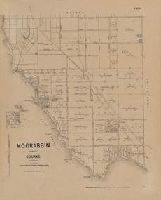 Bayside Gallery - Bayside City Council Art & Heritage Collection
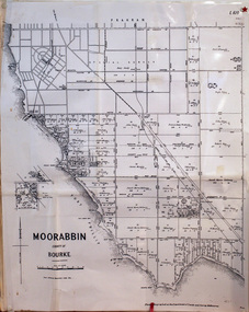
Map, Department of Crown Lands and Survey, Moorabbin, County of Bourke, c. 1918
... Moorabbin, County of Bourke......County of Bourke...The most detail is between Brighton Beach Railway Station (to the north) and just past Rickett's Point (to the south) but the map extends to North Road, Brighton at top. Moorabbin, County of Bourke Map map Department of Crown Lands and Survey ...The cadastral map of the Parish of Moorabbin in Victoria (L.6104) shows parish boundaries and land ownership c. 1918 when Sandringham was a Borough.moorabbin, county of bourke, map, plan, land subdivision, land titles, foreshores, sndringham, hampton, beaumaris, highett, cheltenham, department of lands and survey, land owners, cartographic material, borough of sandringham, brighton -
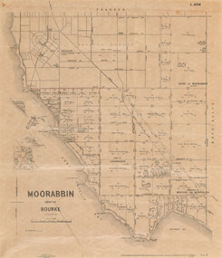 Bayside Gallery - Bayside City Council Art & Heritage Collection
Map, Department of Crown Lands and Survey et al, Moorabbin, County of Bourke, Government Roads, 1920
... Moorabbin, County of Bourke, Government Roads......County of Bourke...Both are set on a cream mount with two window openings. Moorabbin, County of Bourke, Government Roads Map map Department of Crown Lands and Survey W.J. ...The cadastral map of the Parish of Moorabbin in Victoria (L.6104) shows parish boundaries and land ownership 1920 when Sandringham was a Town. The government roads have been coloured in red pencil.moorabbin, county of bourke, map, plan, land subdivision, land titles, foreshores, hampton, beaumaris, highett, cheltenham, department of lands and survey, land owners, cartographic material, brighton, sandringham, town of sandringham, government roads -
 Sunshine and District Historical Society Incorporated
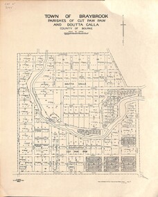
Map - Town of Braybrook Parishes of Cut Paw Paw and Doutta Galla County of Bourke 27th October 1942 Map, Department of Survey Melbourne Victoria, 27th October 1942
... Town of Braybrook Parishes of Cut Paw Paw and Doutta Galla County of Bourke 27th October 1942 Map...Town of Braybrook Parishes of Cut Paw Paw and Doutta Galla County of Bourke 27th October 1942 Map...Braybrook Map Town of Braybrook Parishes of Cut Paw Paw and Doutta Galla County of Bourke 27th October 1942 Map Map Map Town of Braybrook Parishes of Cut Paw Paw and Doutta Galla County of Bourke 27th October 1942 Map Department of Survey Melbourne Victoria ...Town of Braybrook Parishes of Cut Paw Paw and Doutta Galla County of Bourke 27th October 1942 Mapbraybrook, map -
 Sunshine and District Historical Society Incorporated
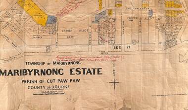
Map - Township of Maribyrnong Maribyrnong Estate Parish of Cut Paw Paw County of Bourke 1925 Map & Town of Braybrook Parish of Cut Paw Paw County of Doutta Galla Map, Department of Lands and Survey Melbourne
... Township of Maribyrnong Maribyrnong Estate Parish of Cut Paw Paw County of Bourke 1925 Map & Town of Braybrook Parish of Cut Paw Paw County of Doutta Galla Map...3188.01 - Township of Maribyrnong Maribyrnong Estate Parish of Cut Paw Paw County of Bourke 20th May 1925 Map|3188.02 - Town of Braybrook Parish of Cut Paw Paw County of Doutta Galla Map 27th October 1942...Maribyrnong 3188.01 - Township of Maribyrnong Maribyrnong Estate Parish of Cut Paw Paw County of Bourke 20th May 1925 Map|3188.02 - Town of Braybrook Parish of Cut Paw Paw County of Doutta Galla Map 27th October 1942 2 maps showing the Township of Maribyrnong 20th May 1925 north of Raleighs Road & Town of Braybrook Parish of Cut Paw Paw County of Doutta Galla Map 1942 Map Township of Maribyrnong Maribyrnong Estate Parish of Cut Paw Paw County of Bourke 1925 Map & Town of Braybrook Parish of Cut Paw Paw County of Doutta Galla Map Department of Lands and Survey Melbourne ...3188.01 - Township of Maribyrnong Maribyrnong Estate Parish of Cut Paw Paw County of Bourke 20th May 1925 Map|3188.02 - Town of Braybrook Parish of Cut Paw Paw County of Doutta Galla Map 27th October 1942maribyrnong -
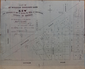 Kew Historical Society Inc
Plan - Framed Subdivision Plan (copy), F Price, Plan of Mr William Derrick's Land, Kew being Subdivision of Part of Section 86, Parish of Boroondara, County of Bourke, 1872, 1872
... Plan of Mr William Derrick's Land, Kew being Subdivision of Part of Section 86, Parish of Boroondara, County of Bourke, 1872...‘Plan of Mr Willia Derrick's Land, Kew being Subdivision of Part of Section 86, Parish of Boroondara, County of Bourke’. This is a copy of the plan held in the State Library of Victoria....Plan of Mr William Derrick's Land, Kew being Subdivision of Part of Section 86, Parish of Boroondara, County of Bourke, 1872 Plan Framed Subdivision Plan (copy) F Price ...William Derrick was an early landowner in Kew, and with James Venn Morgan and James Dannock the purchaser of the parcel of land bounded by Cotham Road, High Street and Mary Street. Derrick Street in Kew is named after him.Map mounted under perspex. ‘Plan of Mr Willia Derrick's Land, Kew being Subdivision of Part of Section 86, Parish of Boroondara, County of Bourke’. This is a copy of the plan held in the State Library of Victoria.kew subdivision plan, john derrick, subdivision plans -- kew (vic.) -
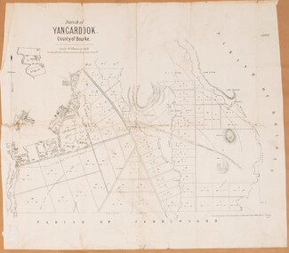 Bacchus Marsh & District Historical Society
Map, Parish of Yangardook, County of Bourke 1876
... Parish of Yangardook, County of Bourke 1876...A single page paper map showing the plan for the Parish of Yangardook in the in the County of Bourke. Scale 40 chains to 1 inch. The map is pasted into a bound volume containing 76 maps or plans in total. ...Parish of Yangardook, County of Bourke 1876 Map Shire of Bacchus Marsh ...The parish of Yangardook lies directly north of the township of Melton. The locality of Toolern Vale lies in the centre of this parish. A single page paper map showing the plan for the Parish of Yangardook in the in the County of Bourke. Scale 40 chains to 1 inch. The map is pasted into a bound volume containing 76 maps or plans in total. High resolution digital image stored on BMDHS computer network. Photo lithographed at the Department of Lands and Survey, Melbourne by J. Noone, 1.8.76yangardook parish maps, toolern vale victoria maps -
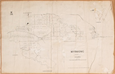 Bacchus Marsh & District Historical Society
Map, Myrniong Parish Map, County of Bourke, 1882
... Myrniong Parish Map, County of Bourke, 1882...A single page paper map showing the map for the Parish of Myrniong in the County of Bourke. A cadastral map showing parish boundaries and land ownership. ...Myrniong Parish Map, County of Bourke, 1882 Map Shire of Bacchus Marsh ...A single page paper map showing the map for the Parish of Myrniong in the County of Bourke. A cadastral map showing parish boundaries and land ownership. The map is pasted into a bound volume containing 76 maps or plans in total. High resolution digital image stored on BMDHS computer network. Photo-lithographed at the Department of Lands and Survey, Melbourne by J. Noone, 17.7.82myrniong parish plan, myrniong parish maps, bacchus marsh region parish plans -
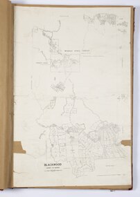
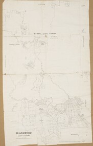 Bacchus Marsh & District Historical Society
Map, Blackwood Parish Map, County of Bourke, 1892
... Blackwood Parish Map, County of Bourke, 1892...A single page paper map showing the map for the Parish of Blackwood in the County of Bourke. A cadastral map showing parish boundaries and land ownership. ...Blackwood Parish Map, County of Bourke, 1892 Map Shire of Bacchus Marsh ...A single page paper map showing the map for the Parish of Blackwood in the County of Bourke. A cadastral map showing parish boundaries and land ownership. The map is pasted into a bound volume containing 76 maps or plans in total. High resolution digital image stored on BMDHS computer network. Photo-lithographed at the Department of Lands and Survey, Melbourne by T.F. McGauran 14.7.92bacchus marsh region parish plans, blackwood parish plan, blackwood parish maps -
 Bacchus Marsh & District Historical Society
Map, Blackwood Parish Map, County of Bourke, 1905
... Blackwood Parish Map, County of Bourke, 1905...A single page paper map showing the map for the Parish of Blackwood in the County of Bourke. A cadastral map showing parish boundaries and land ownership. ...Blackwood Parish Map, County of Bourke, 1905 Map Shire of Bacchus Marsh ...A single page paper map showing the map for the Parish of Blackwood in the County of Bourke. A cadastral map showing parish boundaries and land ownership. The map is pasted into a bound volume containing 76 maps or plans in total. High resolution digital image stored on BMDHS computer network. Photo-lithographed at the Department of Lands and Survey, Melbourne by T.F. McGauran 21.7.05bacchus marsh region parish plans, blackwood parish plan, blackwood parish maps -
 Melbourne Tram Museum
Drawing, "Plan of Survey of Part of Crown Allotments 15 and 16 at Hawthorn, Parish of Boroondara, County of Bourke", 1922
... "Plan of Survey of Part of Crown Allotments 15 and 16 at Hawthorn, Parish of Boroondara, County of Bourke"...Drawing, coloured with water based drawing wash, titled "Plan of Survey of Part of Crown Allotments 15 and 16 at Hawthorn, Parish of Boroondara, County of Bourke". Shows the tram track, Wallen Road, changes around the intersection with Power St, buildings. ..."Plan of Survey of Part of Crown Allotments 15 and 16 at Hawthorn, Parish of Boroondara, County of Bourke" Drawing H. S. McComb ...Drawing, coloured with water based drawing wash, titled "Plan of Survey of Part of Crown Allotments 15 and 16 at Hawthorn, Parish of Boroondara, County of Bourke". Shows the tram track, Wallen Road, changes around the intersection with Power St, buildings. A note at the bottom notes who owns what - MMTB and City of Hawthorn. Prepared by H. S. McComb, licensed Surveyor 6-9-1922. Stored folded.Stamped "Drawing Office" "Office Copy" and in red pencil "Hawthorn" in the bottom right hand corner, and on the rear "Drawing Office" "Office Copy" and "Hawthorn Depot" in pencil.trams, tramways, htt, mmtb, hawthorn depot, plans -
University of Melbourne, Burnley Campus Archives
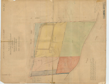
Plan, Plan of Burnley Gardens, City of Richmond, Parish of Jika Jika - County of Bourke, 1927
... Plan of Burnley Gardens, City of Richmond, Parish of Jika Jika - County of Bourke...Plan of Burnley Gardens, City of Richmond, Parish of Jika Jika, County of Bourke. Shows area bounded by Swan St to N, Yarra River to E, Richmond Park on S and W side. ...Plan of Burnley Gardens, City of Richmond, Parish of Jika Jika - County of Bourke Plan ...Plan of Burnley Gardens, City of Richmond, Parish of Jika Jika, County of Bourke. Shows area bounded by Swan St to N, Yarra River to E, Richmond Park on S and W side. Photo-lithographed at Dept. of Lands & Survey by W.J. Butson. Plan shows old orchard, fowl sheds, coops and yards, milking shed, silo, nursery, glasshouse, fattening pens, dairy, garden, orchards area in S.W. area.burnley gardens, orchards, sheds, nursery, silo, dairy -
 Sunshine and District Historical Society Incorporated
Map - Parish of Cut Paw Paw Map County of Bourke, 1952
... Parish of Cut Paw Paw Map County of Bourke...Tony Rigg obtained copies through Brimbank Council Parish CD-ROM in Room 10 Cabinet 4 Drawer Parish of Cut Paw Paw Map (Sheet 2) Map Parish of Cut Paw Paw Map County of Bourke ...Tony Rigg obtained copies through Brimbank CouncilCD-ROM in Room 10 Cabinet 4 Drawerparish -
 City of Moorabbin Historical Society (Operating the Box Cottage Museum)
Document, laminated photocopy of 'Plan of Moorabbin 1850', 1853
... A photocopy of a Map of the Moorabbin , County of Bourke c1850. A3 size laminated...Left corner : MOORABBIN / COUNTY OF / BOURKE...Land Sales proceeded from 1844 as more immigrants established market gardens, farms and varied businesses in 'Moorabbin' This is a photocopy of a Map of the Moorabbin , County of Bourke c1850 showing the 'Henry Dendy Special Survey 1841' dendy henry dendy special survey 1841 brighton moorabbin ormond bentleigh market gardeners pioneers early settlers box william box elizabeth Left corner : MOORABBIN / COUNTY OF / BOURKE A photocopy of a Map of the Moorabbin , County of Bourke c1850. ...Weston Bate, 'A history of Brighton' 1962 informs us that in 1840 Henry Dendy, who was a farmer in Sussex England, paid 5,120 pounds sterling @ 1pound per acre for a 'Special Survey of Land in Port Phillip , Australia. Henry arrived in Australia in 1841 on the frigate 'York' with his wife, son, and three servants. He also took advantage of the Government Assistance of Free Immigrants for Survey Purchasers, to help on his estate and persuaded some Sussex men with their families to follow him. However when Dendy arrived in Port Phillip he found that LaTrobe and Gipps were trying to raise the price of land close to Town to 15pounds per acre. Dendy asked merchant J.B.Were to manage his affairs and they went ahead with plans to subdivide the surveyed land called 'The Brighton Estate' This area of land extended easterly from the Port Phillip Bay to East Boundary Road and from North Road to South Road in the Parish of Bourke Victoria. The Privy Council, England , decide that Henry Dendy could purchase the land at 1pound per acre. Land Sales proceeded from 1844 as more immigrants established market gardens, farms and varied businesses in 'Moorabbin'This is a photocopy of a Map of the Moorabbin , County of Bourke c1850 showing the 'Henry Dendy Special Survey 1841'A photocopy of a Map of the Moorabbin , County of Bourke c1850. A3 size laminatedLeft corner : MOORABBIN / COUNTY OF / BOURKEdendy henry, dendy special survey 1841, brighton, moorabbin, ormond, bentleigh, market gardeners, pioneers early settlers, box william, box elizabeth -
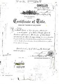 City of Moorabbin Historical Society (Operating the Box Cottage Museum)
Document - Photocopy of Land Title 1881, c1881
... ...county of bourke...This is a Certificate of Title for an acre of land in 'Tucker's Road' purchased by Jabez Gurr in 1881, in the area that was part of the Crown Block known as Henry Dendy's Special Survey 1841, in the Parish of Moorabbin, County of Bourke, Victoria. Following the 'Transfer of Land Statute' allotments in the area of Henry Dendy's Special Survey of 1841 were sold to early settlers. ...3 photocopied pages of the Certificate of Title for approximately 1 acre of land near the corner of Centre Road and Tucker Road, Parish of Moorabbin, County of Bourke, Victoria that was part of the 5,120 acre Henry Dendy Special Survey in Brighton in 1841 and purchased in 1881 by Jabez Gurr. ...City of Moorabbin Historical Society (Operating the Box Cottage Museum) Joyce Park Jasper Road Ormond melbourne This is a Certificate of Title for an acre of land in 'Tucker's Road' purchased by Jabez Gurr in 1881, in the area that was part of the Crown Block known as Henry Dendy's Special Survey 1841, in the Parish of Moorabbin, County of Bourke, Victoria. Following the 'Transfer of Land Statute' allotments in the area of Henry Dendy's Special Survey of 1841 were sold to early settlers. ...This is a Certificate of Title for an acre of land in 'Tucker's Road' purchased by Jabez Gurr in 1881, in the area that was part of the Crown Block known as Henry Dendy's Special Survey 1841, in the Parish of Moorabbin, County of Bourke, Victoria. Following the 'Transfer of Land Statute' allotments in the area of Henry Dendy's Special Survey of 1841 were sold to early settlers. This Certificate of Title shows the passage of history in Moorabbin Shire . Jabez Gurr, a wheelwright, of East Brighton, now Bentleigh East, purchased an acre of land in 'Tucker's Road' , near Centre Road, in 1881. In 1889 he sold to a produce merchant, Robert Smith, and in April 1916 this block was purchased by William Henry George Box, a market gardener and relative of William and Elizabeth Box, who owned the land until 1926. The land was then purchased by Charles John Greenlaw Coates and remained with this family until 1971. All these Family names appear on Councils and Community Boards during the foundation and development of City of Moorabbin3 photocopied pages of the Certificate of Title for approximately 1 acre of land near the corner of Centre Road and Tucker Road, Parish of Moorabbin, County of Bourke, Victoria that was part of the 5,120 acre Henry Dendy Special Survey in Brighton in 1841 and purchased in 1881 by Jabez Gurr. It records subsequent proprietors up to 1971Stamped CANCELLED 12 OCT 1994 (top Right) / Entered in the Register Book / Vol.1245 Fol. 248877/ signed Henry Crowe / Assistant Registrar of Titles / Coat of Arms / VICTORIA / Certificate of Title / UNDER THE ' TRANSFER OF AND STATUTE' /dated ' eleventh day of April one thousand eight / hundred and eighty one' / signed 'Henry Crowe' / Assistant Registrar of Titles/ ENCUMBRANCES REFERRED TO / circular Stamp 'OFFICE OF TITLES VICTORIA' / Drawn and shaded on the left side is the area of land in "Tucker's" Road 3331/3 links fro Centre Road, 150 links x 6662/3 links / The measurements are in linksdendy henry, dendy's special survey 1841, brighton, moorabbin, bentleigh, market gardeners, early settlers, pioneers, wheelwrights, merchants, fruit gardens, markets, smith robert, box william henry george, gurr jabez, county of bourke, victoria, melbourne, land statutes, tucker road, centre road, box william, box elizabeth, box cottage museum -
 Whitehorse Historical Society Inc.
Document, Plan of Blackburn, 1886
... ...county of bourke...Crown grants, Parish of Nunawading, County of Bourke, covers the Blackburn area....Whitehorse Historical Society Inc. 2-10 Deep Creek Road Mitcham melbourne woods john purches edwin james coppin george seth parish of nunawading county of bourke blackburn tranter william orr joseph whitman frank Crown grants, Parish of Nunawading, County of Bourke, Crown grants, Parish of Nunawading, County of Bourke, covers the Blackburn area. ...Crown grants, Parish of Nunawading, County of Bourke,Crown grants, Parish of Nunawading, County of Bourke, covers the Blackburn area.Crown grants, Parish of Nunawading, County of Bourke,woods, john, purches, edwin james, coppin, george seth, parish of nunawading, county of bourke, blackburn, tranter, william, orr, joseph, whitman, frank -
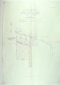 Eltham District Historical Society Inc
Slide - Photograph, Eltham Shire Council, Plan of Subdivision, Part of Crown Portion 3, Parish of Nillumbik, County of Bourke, 1969
... Plan of Subdivision, Part of Crown Portion 3, Parish of Nillumbik, County of Bourke...Eltham District Historical Society Inc 728 Main Rd Eltham melbourne Infrastructure Map Montmorency planning Rattray Road Subdivison Lots Reichelt Avenue C5C, Delbridge, 4 lots, Rattray Road, 4 August 1969 35mm colour positive transparency blue Agfacolour Service plastic mount Plan of Subdivision, Part of Crown Portion 3, Parish of Nillumbik, County of Bourke Slide Photograph Eltham Shire Council ...35mm colour positive transparency blue Agfacolour Service plastic mountC5C, Delbridge, 4 lots, Rattray Road, 4 August 1969infrastructure, map, montmorency, planning, rattray road, subdivison lots, reichelt avenue