Showing 82 items matching " economic growth"
-
 Port Melbourne Historical & Preservation Society
Book, Charles Wilson, The History of Unilever. A Study in economic growth and social change. Vols I & II, 1954
... The History of Unilever. A Study in economic growth and social change. Vols I & II..."The History of Unilever. A Study in economic growth and social change. Vols I & II" Books written by Charles Wilson, Fellow of Jesus College, Cambridge. ...J Kitchen & Sons and Apollo Company in Australia included The History of Unilever. A Study in economic growth and social change. Vols I & II Book Charles Wilson Cassell and Company Ltd Curwen Press ..."The History of Unilever. A Study in economic growth and social change. Vols I & II" Books written by Charles Wilson, Fellow of Jesus College, Cambridge. Published 1954. J Kitchen & Sons and Apollo Company in Australia includedindustry - manufacturing, business and traders - soaps/candles, j kitchen & sons pty ltd, unilever australia (holdings) ltd, apollo candle co -
Federation University Historical Collection
Book - Book - Scrapbook, Ballarat College of Advanced Education: Scrapbook of newspaper cutting, Book 9; March 1981 to September 1981
... ...way to economic growth...Many items are dedicated to the opening of Founder's Hall. . employment advertisements application for enrolment outline of courses wind power at bcae cash outlook gloomy concert to celebrate hall opening grim look for teachers opening of founder's hall conferring of degrees at founder's hall bhp chief at degree conferring way to economic growth education mission from china library award to bcae student helen hately 50 years on college enrolments climb ronald potter winner of a e stohr medal of the institution of engineers stop college cuts political bias denied protest at education cuts graduate tom honeyman at bcae college water supply bcae field trip to western australia lectures for industry bill rofe zig plavina careers in sciences seminar fitness for volunteers study of walnuts a hit siddons plan solar heating thrust william charters inventor jobs that go begging shortage of engineers careers seminar at bcae morgan john retires prints by students on show pam dethridge hard work pays off labor pledge on education unemployment in ballarat bcae student dinner advanced learning program for secondary students first exhibition for eric collins 30 escape bus crash mining cadetship awarded to tom devries bcae open day technology week getting the facts at bcae memorial lecture prof weston bate tertiary education disadvantaged goldrush miners relied on luck more tafe funding 'not enough' equus ready for stage mineral exports vital Book with grey cover, front. ...Newspaper cuttings relating to Ballarat College of Advanced Education. These are from various newspapers and include The Age, Ballarat Courier, The Australian, The Herald. The cuttings cover the period from 12 March 1981 to 1 September 1981. Many items are dedicated to the opening of Founder's Hall. . Book with grey cover, front. Image of draught horses. Spiral bound.employment advertisements, application for enrolment, outline of courses, wind power at bcae, cash outlook gloomy, concert to celebrate hall opening, grim look for teachers, opening of founder's hall, conferring of degrees at founder's hall, bhp chief at degree conferring, way to economic growth, education mission from china, library award to bcae student, helen hately, 50 years on, college enrolments climb, ronald potter winner of a e stohr medal of the institution of engineers, stop college cuts, political bias denied, protest at education cuts, graduate tom honeyman at bcae, college water supply, bcae field trip to western australia, lectures for industry, bill rofe, zig plavina, careers in sciences seminar, fitness for volunteers, study of walnuts a hit, siddons plan solar heating thrust, william charters inventor, jobs that go begging, shortage of engineers, careers seminar at bcae, morgan john retires, prints by students on show, pam dethridge, hard work pays off, labor pledge on education, unemployment in ballarat, bcae student dinner, advanced learning program for secondary students, first exhibition for eric collins, 30 escape bus crash, mining cadetship awarded to tom devries, bcae open day, technology week, getting the facts at bcae, memorial lecture, prof weston bate, tertiary education disadvantaged, goldrush miners relied on luck, more tafe funding 'not enough', equus ready for stage, mineral exports vital -
Glenelg Shire Council Cultural Collection
Poster, 1958
... ... economic growth...Glenelg Shire Council Cultural Collection History House Cliff Street Portland great-ocean-road Retrieved from the files of the former Maritime Discovery Centre Manager at the Portland Visitor Information Centre. ( Note accompanying suggests it was donated by ex-tugman Ross Martin) Portland Harbour Trust loan finance 1958 Portland economic growth economy Front: 1958, Top Right, Pencil Poster promoting investment in the Portland Harbour Trust's £100,000 loan Poster Poster ...Retrieved from the files of the former Maritime Discovery Centre Manager at the Portland Visitor Information Centre. ( Note accompanying suggests it was donated by ex-tugman Ross Martin)Poster promoting investment in the Portland Harbour Trust's £100,000 loanFront: 1958, Top Right, Pencilportland harbour trust, loan, finance, 1958, portland, economic growth, economy -
Whitehorse Historical Society Inc.
Article, Taking up the tough challenge, 1991
... Need for elected officials and the world of business to lead the way for initiating economic growths to lead the way out of recession. ...Need for elected officials and the world of business to lead the way for initiating economic growths to lead the way out of recession. ...Need for elected officials and the world of business to lead the way for initiating economic growths to lead the way out of recession.Need for elected officials and the world of business to lead the way for initiating economic growths to lead the way out of recession. Barry Richardson, flag maker, is one such example.Need for elected officials and the world of business to lead the way for initiating economic growths to lead the way out of recession. richardson, barry, flag manufacturers -
 Seaworks Maritime Museum
Plaque
... Korean writing "Korea Maritime and Port Administration" verso "Vault Beyond the Seas/ on the 13th March 1977/ Park Chung Hee, President/ Our motto, presented by the President on the/ first anniversary of the founding of the Korea Maritime/ and Port Administration represents our mission and our/ inspiration to pace the dynamic economic growth of our/ Republic in joining the ranks of the great maritime/ countries of the world" "WMA 66" "PMA 0262"...Seaworks Maritime Museum 82 Nelson Place Williamstown melbourne Korean writing "Korea Maritime and Port Administration" verso "Vault Beyond the Seas/ on the 13th March 1977/ Park Chung Hee, President/ Our motto, presented by the President on the/ first anniversary of the founding of the Korea Maritime/ and Port Administration represents our mission and our/ inspiration to pace the dynamic economic growth of our/ Republic in joining the ranks of the great maritime/ countries of the world" "WMA 66" "PMA 0262" Small plaque with Korean writing in perspex Plaque ...Small plaque with Korean writing in perspexKorean writing "Korea Maritime and Port Administration" verso "Vault Beyond the Seas/ on the 13th March 1977/ Park Chung Hee, President/ Our motto, presented by the President on the/ first anniversary of the founding of the Korea Maritime/ and Port Administration represents our mission and our/ inspiration to pace the dynamic economic growth of our/ Republic in joining the ranks of the great maritime/ countries of the world" "WMA 66" "PMA 0262" -
 Bendigo Historical Society Inc.
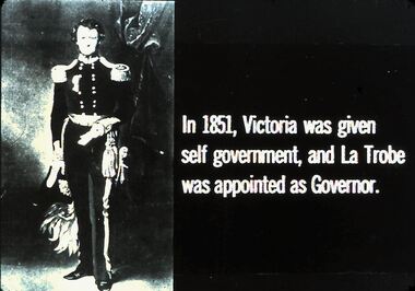
Slide - DIGGERS & MINING. THE GOLD ERA, c1851
... He resigned in 1852 after having difficulty coping with the rapid increase of Victoria's population and economic growth. ...He resigned in 1852 after having difficulty coping with the rapid increase of Victoria's population and economic growth. EDUCATION Tertiary goldfields hanimount Diggers & mining. ...Charles La Trobe (1801-18750 was initially the Superintendent of the Port Phillip District (1839). When Victoria became a separate colony in 1851 La Trobe became the first Lieutenant Governor. He resigned in 1852 after having difficulty coping with the rapid increase of Victoria's population and economic growth. Diggers & mining. The gold era. In 1851, Victoria was given self government, and La Trobe was appointed as Governor. Governor La Trobe is pictured in the slide. Markings 36 994.031 GOL:5. Used as a teaching aid.hanimounteducation, tertiary, goldfields -
 Bendigo Historical Society Inc.
Newspaper - Fortuna Article - "DIGO's new home opens", Nov 13 2008
... The new DIGO facility is expected to promote local employment and economic growth. Defence Minister Joel Fitzgibbon visited Thales Australia, which designs and produces the Bushmaster Protected Mobility Vehicle.Defence recently ordered 293 more Bushmasters, totaling 737 vehicles....The new DIGO facility is expected to promote local employment and economic growth. Defence Minister Joel Fitzgibbon visited Thales Australia, which designs and produces the Bushmaster Protected Mobility Vehicle.Defence recently ordered 293 more Bushmasters, totaling 737 vehicles. bendigo fortuna george lansell digo geospatial intelligence Fortuna Article - "DIGO's new home opens" - The Bendigo Miner Thursday Nov 13 2008 Picutres Julian Prowd This item contains the following: 11217.20a Colour Photo of Joel Fitzgibbon 11217.20b Part of page 5 - Article "DIGO's new home opens" Newspaper Fortuna Article - "DIGO's new home opens" ...The article highlights the opening of the $52 million Defence Imagery and Geospatial Organisation (DIGO) facility in Junortoun, Bendigo, emphasizing its strategic and economic significance The new DIGO centre is the sole provider of geospatial intelligence for Australia's defence and national interests. The facility ensures DIGO remains a world-class organization in geospatial information and services. Bendigo has been important to Australia's defence since 1942, previously hosting Defence mapping at the Fortuna site. Defence spends about $130 million annually in Bendigo on personnel, equipment, services, and facilities. The new DIGO facility is expected to promote local employment and economic growth. Defence Minister Joel Fitzgibbon visited Thales Australia, which designs and produces the Bushmaster Protected Mobility Vehicle.Defence recently ordered 293 more Bushmasters, totaling 737 vehicles.Fortuna Article - "DIGO's new home opens" - The Bendigo Miner Thursday Nov 13 2008 Picutres Julian Prowd This item contains the following: 11217.20a Colour Photo of Joel Fitzgibbon 11217.20b Part of page 5 - Article "DIGO's new home opens" non-fictionbendigo, fortuna, george lansell, digo, geospatial intelligence -
 Bendigo Historical Society Inc.
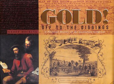
Book - "Gold! Off to the Diggings", 2010
... Gold mining in Australia has a rich history that began in the early 19th century, leading to significant economic growth and population influx during the gold rushes of the 1850s. ...Gold mining in Australia has a rich history that began in the early 19th century, leading to significant economic growth and population influx during the gold rushes of the 1850s. ...A pictorial history of the Australian goldrush. In 1851 Australia's gold rush had begun, and the focus of the world suddenly turned to the hills, gullies and creeks of New South Wales and Victoria as people from all over the world rushed to the diggings. Gold mining in Australia has a rich history that began in the early 19th century, leading to significant economic growth and population influx during the gold rushes of the 1850s. The first documented discovery of gold in Australia occurred in 1823 near Bathurst, New South Wales. However, it wasn't until 1851 that significant gold deposits were found at Ophir, which triggered the first major gold rush. The discovery of payable gold led to a massive influx of prospectors and miners from around the world, particularly during the Victorian Gold Rush. By the mid-1850s, Australia was producing nearly 40% of the world's gold. The gold rushes significantly increased Australia's population, with estimates suggesting that the population tripled from 1851 to 1860 due to the influx of miners and their families. Economic Contributions: Gold mining became a cornerstone of the Australian economy, contributing to export income and the development of infrastructure. The wealth generated from gold mining helped finance the young colonies and led to the establishment of new towns and services."Gold! Off to the Diggings" by Geoff Hocking. Published by New Chum Press in 2010. Hard cover book which is black fabric. Title and author's name in gold on spine. Dust jacket is multi-colored, with different gold mining scenes on front and back. Title written on gold and black on front cover and spine. Printed in Castlemaine, Australia. 320 pp. Glossy pages. Contains both text and black and white images. Has index. ISBN 9780957897236. gold, mining, miners -
 Eltham District Historical Society Inc
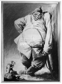
Photograph, Percy Leason, Cartoon "Goliath and the Prodical David", Percy Leason, 1931, 1931
... This political cartoon depicts a black and white drawing; “General Depression”, a large ugly man wearing a German pike helmut, representing the Great Depression which Australians suffered from 1929 through the 1930s with a period of high unemployment, poverty, low profits, deflation, plunging incomes, and lost opportunities for economic growth and personal advancement. This figure overshadows a small man, representing Prime Minster James Scullin with a suitcase labelled “Jim S, London to Australia”. ...Eltham District Historical Society Inc 728 Main Rd Eltham melbourne This political cartoon depicts a black and white drawing; “General Depression”, a large ugly man wearing a German pike helmut, representing the Great Depression which Australians suffered from 1929 through the 1930s with a period of high unemployment, poverty, low profits, deflation, plunging incomes, and lost opportunities for economic growth and personal advancement. This figure overshadows a small man, representing Prime Minster James Scullin with a suitcase labelled “Jim S, London to Australia”. ...This political cartoon depicts a black and white drawing; “General Depression”, a large ugly man wearing a German pike helmut, representing the Great Depression which Australians suffered from 1929 through the 1930s with a period of high unemployment, poverty, low profits, deflation, plunging incomes, and lost opportunities for economic growth and personal advancement. This figure overshadows a small man, representing Prime Minster James Scullin with a suitcase labelled “Jim S, London to Australia”. This is a reference to the PM’s decision to travel to London to seek an emergency loan and to attend the Imperial Conference (a meeting of Prime Ministers of the British Empire) He is holding a sling shot. The image has a “David and Goliath theme” denoting Australia as the underdog, a contest where a smaller, weaker opponent faces a much bigger, stronger adversary. The artist Percy Leason (1889 - 1959) was a painter and cartoonist renowned for his depictions of Australian society in the 1920s and 1930s. He lived in Eltham at his property 'Landscape' which he built in New Street (present day Lavender Park Road) from about 1924 to 1938 when he moved to the USA. In 1931 his cartoons were published in the Melbourne magazine “Table Talk” (although it cannot be confirmed that this one was). The original source of this image for the SEPP collection was the Publisher Thomas Nelson based in Melbourne. This photo forms part of a collection of photographs gathered by the Shire of Eltham for their centenary project book,"Pioneers and Painters: 100 years of the Shire of Eltham" by Alan Marshall (1971). The collection of over 500 images is held in partnership between Eltham District Historical Society and Yarra Plenty Regional Library (Eltham Library) and is now formally known as 'The Shire of Eltham Pioneers Photograph Collection.' It is significant in being the first community sourced collection representing the places and people of the Shire's first one hundred years.Digital image and 4 x 5 inch B&W Negsepp, shire of eltham pioneers photograph collection, percy leason, depression, cartoon, comic, james scullin, david and goliath, drawing, political cartoon -
 Federation University Historical Collection
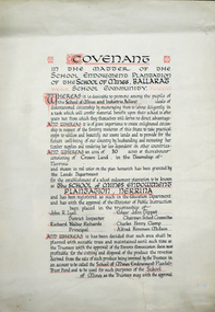
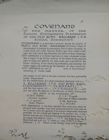
Certificate, Ballarat School of Mines Endowment Plantation, Nerrina Covenant, c1958, c1958
... In some cases, however, these plantations have not been very successful in providing revenue, as the sites are unsuitable for economic growth or the plantations are too small or the location too far from processing centres to allow economic harvesting. ...In some cases, however, these plantations have not been very successful in providing revenue, as the sites are unsuitable for economic growth or the plantations are too small or the location too far from processing centres to allow economic harvesting. ...Throughout the Nerrina district numerous areas of public land were set aside as school endowment plantations as part of various schools’ educational resources. The plantations were initially established to instil through community involvement a love of forests and an appreciation of their value, and in fact many of them are well suited for regular use as a teaching resource of this nature. It was expected that this use will increase as courses embracing various aspects of environmental science are developed. Many school plantations have been planted to radiata pine, and revenue from the sale of produce used to provide amenities required by the schools. In some cases, however, these plantations have not been very successful in providing revenue, as the sites are unsuitable for economic growth or the plantations are too small or the location too far from processing centres to allow economic harvesting. In some instances, radiata pine plantations have failed due to poor management. In 1982 the Land Conservation Council believed that all the existing plantations should be assessed in order to establish their value as a teaching resource. Those not needed or that are unsuitable for teaching purposes for some reason, such as their location, should be terminated. Those planted to radiata pine that have limited value as a teaching resource although satisfactory for wood production may continue to be used for such production, but should be reviewed when the pines are harvested. (http://www.veac.vic.gov.au/reports/354-Ballarat-Study-Area.pdf, acccessed 30/03/2017) The School Endowment Plantation Scheme was established in 1922 as a joint venture between the Education Department and the FCV. It was administered by the Education Department with technical supervision by the Commission. While some plantations were established on private land donated or leased for the purpose, most were established on Crown Lands or Reserved Forest made available, without cost, by the State. (https://www.victoriasforestryheritage.org.au/community/schools.html, accessed 26 September 2020)Covenant in the matter of the School Endowment Plantation of the School of Mines Ballarat School Community.nerrina pine plantation, ballarat school of mines endowment plantation, nerrina, pine plantation, nerrina, john r. lyall, richard w. richards, dick richards, edgar j. tippett, charles h. clamp, alfred k. mcbain, endowment plantation -
 Federation University Historical Collection
Certificate, Ballarat Junior Technical School Old Boys Association Endowment Plantation, c1928, c1928
... In some cases, however, these plantations have not been very successful in providing revenue, as the sites are unsuitable for economic growth or the plantations are too small or the location too far from processing centres to allow economic harvesting. ...In some cases, however, these plantations have not been very successful in providing revenue, as the sites are unsuitable for economic growth or the plantations are too small or the location too far from processing centres to allow economic harvesting. ...The School Endowment Plantation Scheme was established in 1922 as a joint venture between the Education Department and the FCV. It was administered by the Education Department with technical supervision by the Commission. While some plantations were established on private land donated or leased for the purpose, most were established on Crown Lands or Reserved Forest made available, without cost, by the State. (https://www.victoriasforestryheritage.org.au/community/schools.html, accessed 26 September 2020) Throughout the Nerrina district numerous areas of public land were set aside as school endowment plantations as part of various schools’ educational resources. The plantations were initially established to instil through community involvement a love of forests and an appreciation of their value, and in fact many of them are well suited for regular use as a teaching resource of this nature. It was expected that this use will increase as courses embracing various aspects of environmental science are developed. Many school plantations have been planted to radiata pine, and revenue from the sale of produce used to provide amenities required by the schools. In some cases, however, these plantations have not been very successful in providing revenue, as the sites are unsuitable for economic growth or the plantations are too small or the location too far from processing centres to allow economic harvesting. In some instances, radiata pine plantations have failed due to poor management. In 1982 the Land Conservation Council believed that all the existing plantations should be assessed in order to establish their value as a teaching resource. Those not needed or that are unsuitable for teaching purposes for some reason, such as their location, should be terminated. Those planted to radiata pine that have limited value as a teaching resource although satisfactory for wood production may continue to be used for such production, but should be reviewed when the pines are harvested. (http://www.veac.vic.gov.au/reports/354-Ballarat-Study-Area.pdf, acccessed 30/03/2017)Covenant in the matter of the School Endowment Plantation of the Ballarat Junior Technical School Old Boys Association Endowment Plantation.pine plantation, alfred k. mcbain, g.w.e. pearson, i.c. garner, a.m. robinson, h.j. hassell, ballarat junior technical school old boys association endowment plantation, ballarat junior technical school, alumni -
 Bendigo Historical Society Inc.
Newspaper - Fortuna Articles - "A Vision for Fortuna Villa", Feb 20 2009
... Fortuna Villa could become a major asset for Bendigo, enhancing its profile and supporting economic growth. Cultural tourism is highlighted as a rapidly growing sector, with visitors who stay longer and spend more. ...Fortuna Villa could become a major asset for Bendigo, enhancing its profile and supporting economic growth. Cultural tourism is highlighted as a rapidly growing sector, with visitors who stay longer and spend more. ...This document by Beverley Carter, (Lansell family historian) explores the future potential of Fortuna Villa in Bendigo, emphasizing its significance for community, tourism, and economic development. The Defence Department has vacated Fortuna Villa after more than 60 years. There is an opportunity for public ownership, with state or local government having first refusal, ensuring community access. Fortuna Villa could become a major asset for Bendigo, enhancing its profile and supporting economic growth. Cultural tourism is highlighted as a rapidly growing sector, with visitors who stay longer and spend more. The success of recent cultural events in Bendigo, such as the Golden Age of Couture exhibition, demonstrates the city's capacity to attract international attention. The Villa Fortuna Action Group proposes transforming the site into a hub for cultural, commercial, and community activities. Suggested uses include concerts, festivals, exhibitions, heritage tours, retail outlets, community meetings, conferences, weddings, and fine dining. The document references successful models like Abbotsford Convent and Werribee Mansion in Victoria, and Hylands House in the UK, as examples of adaptive reuse. While acknowledging significant short-term costs, the document argues that long-term financial and social benefits outweigh these concerns. The project is seen as a way to diversify the local economy, create jobs, and foster business partnerships.The author rejects the notion that tough economic times should prevent investment, suggesting such projects can help mitigate downturns. Fortuna Villa is presented as a once-in-a-lifetime chance for Bendigo to secure a property that symbolizes the city's golden past. The author stresses the importance of a comprehensive, coordinated approach to tourism in the region, with Fortuna Villa as a potential centerpiece.Urgency: There is a strong call to action, suggesting that the community must act quickly to secure the property before it is lost to others. The document is authored by Beverley Carter, a member of the Lansell family, who is writing a detailed family history and a series on George Lansell and Fortuna Villa, further underlining the site's historical importance.Fortuna Articles - "A Vision for Fortuna Villa" Feb 20 2009 The Bendigo Advertiser by Beverley Carter, photo by Julian Prowd This item contains the following: 11217.36a Colour Photo of Fortuna 11217.36b Part of Page 14 - "A Vision for Fortuna Villa" 11217.36c Part of Page 14 - "A Vision for Fortuna Villa"non-fictionbendigo, fortuna, george lansell, villa fortuna action group, beverley carter -
 Flagstaff Hill Maritime Museum and Village
Book - Reference Book/History, Henry Smith Williams, The Historians History of the World Vol 10 set 1 - Edited by Henry Smith Williams L.L.D. Published by “The Times” 1908, 1908
... While religious unity is credited with consolidating the fragmented Spanish kingdoms of Castile and Aragon, the text critiques that the Spanish Inquisition as a force eventually stifled intellectual growth and economic diversity by expelling the Jews and Spanish Muslims or their descendants who had become baptised Christians from Spain. ...While religious unity is credited with consolidating the fragmented Spanish kingdoms of Castile and Aragon, the text critiques that the Spanish Inquisition as a force eventually stifled intellectual growth and economic diversity by expelling the Jews and Spanish Muslims or their descendants who had become baptised Christians from Spain. ...The 1908 edition of The Historians' History of the World is a monumental work of Edwardian scholarship, representing a specific era of "universal history" where the goal was to synthesise all human knowledge into a single narrative. Volume 10 specifically focuses on the Late “Middle Ages” and the “Renaissance period”, particularly in Italy and Spain. Starting with the clash of civilisations, Islam vs. Christianity.The Book is part of a 25 volume set with red cloth bindings and gold filigree design to rib.non-fictionThe 1908 edition of The Historians' History of the World is a monumental work of Edwardian scholarship, representing a specific era of "universal history" where the goal was to synthesise all human knowledge into a single narrative. Volume 10 specifically focuses on the Late “Middle Ages” and the “Renaissance period”, particularly in Italy and Spain. Starting with the clash of civilisations, Islam vs. Christianity. flagstaff hill, warrnambool, shipwrecked-coast, flagstaff-hill, flagstaff-hill-maritime-museum, maritime-museum, shipwreck-coast, flagstaff-hill-maritime-village, the historians history of the world vol 10 set 1, book -
 Kiewa Valley Historical Society
Book - Sketch Book, Circa 1918
... economic factors and mores were also similar. This item demonstrates the relocation of one family from Tasmania to the Kiewa Valley. The expansion in population into the Kiewa valley was quite erratic and significant population growth only came after the increase in population brought into the area by the SEC Vic Hydro Scheme introduced to quench the demand for Victoria's electricity. 1918's educational sketchbook 1918 children's sketchbook On the outside cover and contained within a thick boarder. ...This childhood sketchbook of the 1918 era details the emphasis placed upon a skill of brushwork that portrayed part of the students natural environment both in Tasmanian schools and Victorian schools, especially rural schools. The close bondage between students and their environment was a reflection on the early "hands on" approach in child education. Abstract art or teaching aids which could not be identified with physical properties available to students at this period in time were of lesser value. The ability of the student to identify the artistic value of local nature eg. local plants and flowers was especial important to rural based school children who had limited excursion opportunities available to visit town/city based botanical gardens and museums. This brushwork book is very significant to the Kiewa Valley as it demonstrates that childhood relocations from one State to another were not detrimental to the students overall scholastic development. The rural environment in Tasmania was not that far removed from the rural environment of the Kiewa Valley. The skills taught in both regions were still the same and the socio-economic factors and mores were also similar. This item demonstrates the relocation of one family from Tasmania to the Kiewa Valley. The expansion in population into the Kiewa valley was quite erratic and significant population growth only came after the increase in population brought into the area by the SEC Vic Hydro Scheme introduced to quench the demand for Victoria's electricity.This book has a brown cover with black print and designs on a 150 gsm cardboard. Each page is of the same thickness as the cover but is of paper.On the outside cover and contained within a thick boarder. "EDUCATION DEPARTMENT" and below this in smaller print "TASMANIA" below this "THE TASMANIAN BRUSHWORK BOOK". Below this "FOR CLASSES IV., V., AND VI" Below this "NAME" SCHOOL" At the bottom 2 1/2d1918's educational sketchbook, 1918 children's sketchbook -
 Kiewa Valley Historical Society
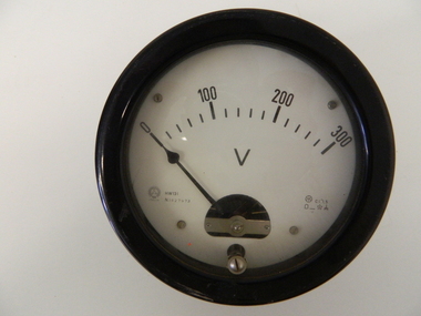
Meter Volt, mid to late 1900's
... This evolution in the valley created a change, not only in the "physical" landscape but also the socio-economic expansion which permitted other "tourist" based industries into the valley. kiewa valley tourism victorian alps alternate energy supplies alpine population growth Manufacturer's logo "CSG" underneath "ITALIA" This analog volt meter has two metal rods protruding from the "back" of instrument with screw on points for the negative and the positive leads allowing the "current" to flow across the calibrated resistors to indicate on the "face" side the strength of the voltage "power". ...This analog voltmeter is quite a large (industrial type) apparatus which permits the easy monitoring of electrical variations within the large SEC Victoria Hydro Scheme's electrical generators. These generators are powered by the hydro force of "stored" water at a higher altitude. The establishment of both the NSW and Victorian Hydro schemes was achieved from the mid 1900's to the 1960's. At this point in time the need for additional power sources to quench both an industrial and domestic demand for electricity was purely an economic and not and environmental (carbon reduction) factor. This hydro scheme was instigated by "the Government of the day" as a bold move and was the major force of the World War II refugee and "technical" workforce inclusion of skilled and unskilled migration into the Australian environment. Although this mass "invasion" of workers with families was thought of in some circles as intrusive, the expansion of population post war years and its integration into the Australian rural sector, produced the multi- lingual multi-cultural diversity of later years. This voltmeter is very significant to the Kiewa Valley as its use was introduced during the Kiewa Hydro Scheme. Although only a small apparatus it was part of the explosion of human resources into the valley. This influx of population transformed the region from that of a basically quiet rural region to one which evolved into both an industrial and a larger residential community. This evolution in the valley created a change, not only in the "physical" landscape but also the socio-economic expansion which permitted other "tourist" based industries into the valley. This analog volt meter has two metal rods protruding from the "back" of instrument with screw on points for the negative and the positive leads allowing the "current" to flow across the calibrated resistors to indicate on the "face" side the strength of the voltage "power". The "face" of the instrument has a zero point and then five evenly graduated marks from Zero to the "100, 200 and 300" marked points of measures. A large "V" below these pointers indicates that they represent levels of voltage. Three small screws hold the "face" in place. At the back of the meter is an aluminium "clasp" with three protruding screws (positioning fasteners) and a a screw tightening fixture for the correct fastening of the "clasp" into the correction location on the meter "board".Manufacturer's logo "CSG" underneath "ITALIA"kiewa valley tourism, victorian alps, alternate energy supplies, alpine population growth -
 Kiewa Valley Historical Society
Meter Millivolt, after 1950
... This evolution in the Kiewa Valley created a change, not only in the "physical" landscape(better roads and infrastructure), but also the socio-economic growth within the Valley allowing other "tourist" based industries to expand within the valley and Alpine areas. kiewa valley tourism victorian alps alternate energy supplies alpine population growth On the face of the millivolt compartment , and at the top "TO BE USED WITH DIAL HORIZONTAL TEMP. ...This milli-volt meter was manufactured after 1950 and used by the SEC Vic (Kiewa Hydro Electricity Scheme) from that date until late 1900's. It was used to measure very small voltages associated with the operation of the various Hydro Generators. The readings were able to be shown by the resistor in use in the current circuit. During this time period, high quality testing instruments were either sourced from Europe or England.This milli-volt meter is very significant to the Kiewa Valley as it was used by those electrical technicians, who were part of the Kiewa Hydro Scheme. An "off spin" from the Scheme was the beginning of an explosion in "human" resources into the Kiewa Valley. This influx of population transformed the region from that of a basically quiet rural region to one which evolved into both industrial and larger residential community. This evolution in the Kiewa Valley created a change, not only in the "physical" landscape(better roads and infrastructure), but also the socio-economic growth within the Valley allowing other "tourist" based industries to expand within the valley and Alpine areas.This millivolts DC meter was used in the 1950's. It is contained in a wooden box and has two coloured (red/black, positive and negative) screw tight knobs which have bake-lite connections. It also has a covered (black tin) view meter marked from zero to 10 millivolts. Underneath this and within a round bake-lite is a small adjustment screw. The top of the box is fastened onto the main structure by six brass screws. The back of the structure is fastened by eight brass screws and there are four small bake-lite rest knobs.On the face of the millivolt compartment , and at the top "TO BE USED WITH DIAL HORIZONTAL TEMP. COEF. +- .08 % PER oC. Underneath the scale "MILLIVOLTS D.C. F.G." (LEAD RESIS. .05 OHMS)" underneath and to the left "MADE IN ENGLAND BY" "EVERSHED & VIGNOLES Ltd" and to the right "No. 857842" underneath Regd. TRADE MARK MEGGERkiewa valley tourism, victorian alps, alternate energy supplies, alpine population growth -
 Kiewa Valley Historical Society
Meter Multi General Purpose, circa mid to late 1900's
... economic and not and environmental (carbon reduction) factor. This hydro scheme was instigated by "the Government of the day" as a bold move and was the major force of the World War II refugee and "technical" workforce inclusion of skilled and unskilled migration into the Australian environment. Although this mass "invasion" of workers with families was thought of in some circles as intrusive, the expansion of population post war years and its integration into the Australian rural sector, produced the multi- lingual multi-cultural diversity of later years. sec vic kiewa hydro scheme alternate energy supplies alpine population growth Front "H&B ELIMA" and to the right Elavi 15n. 0n the front side is a label "STATE ELECTRICITY COMMISSION OF VICTORIA TRANSMISSION DEPT E.C.No." ...This general purpose Multi-meter was manufactured after 1950 and used by the SEC Vic (Kiewa Hydro Electricity Scheme) from that date until late 1900's. It was used to measure very small voltages associated with the operation of the various Hydro Generators. The readings were able to be shown by the resistor in use in the current circuit. During this time period, high quality testing instruments were either sourced from Europe or England. This particular meter was manufactured in the Netherlands. This type of "old" analogue meter was replaced by digital meters whose electronic components are a fraction of the size of the older analogue ones.This analog General Purpose multi-meter is quite a large (for handheld mobile) apparatus which permits the easy monitoring of electrical variations within the large SEC Victoria Hydro Scheme's electrical generators. These generators are powered by the hydro force of "stored" water at a higher altitude. The establishment of both the NSW and Victorian Hydro schemes was achieved from the mid 1900's to the 1960's. At this point in time the need for additional power sources to quench both an industrial and domestic demand for electricity was purely an economic and not and environmental (carbon reduction) factor. This hydro scheme was instigated by "the Government of the day" as a bold move and was the major force of the World War II refugee and "technical" workforce inclusion of skilled and unskilled migration into the Australian environment. Although this mass "invasion" of workers with families was thought of in some circles as intrusive, the expansion of population post war years and its integration into the Australian rural sector, produced the multi- lingual multi-cultural diversity of later years.This General Purpose Multimeter is an analogue meter i.e. it has a needle arm that moves across a scale of divisions. This is a large(hand held) device due to the mechanical movement system within and the large size of its electronic components of its circuitry.There are two black bake-lite push buttons operating the wire inserts Positive/negative leads at the top. The meter (protected with a glass window) has clearly marked graduations (top - volts, bottom amperes). Below this are two bake-lite dials (left "potentiometer the right one measuring range selector). Below this is a "dial" switch to input the desired resistance measuring range "V" Front "H&B ELIMA" and to the right Elavi 15n. 0n the front side is a label "STATE ELECTRICITY COMMISSION OF VICTORIA TRANSMISSION DEPT E.C.No." On the bottom of the base is a stenciled layout of the battery "layout" including the fuse . The information notice is presented in five languages starting with German, English,French, Italian, Spanish and Dutchsec vic kiewa hydro scheme, alternate energy supplies, alpine population growth -
 Kiewa Valley Historical Society
Case for G.P. Multimeter, Circa 1950
... economic and not and environmental (carbon reduction) factor. This hydro scheme was instigated by "the Government of the day" as a bold move and was the major force of the World War II refugee and "technical" workforce inclusion of skilled and unskilled migration into the Australian environment. Although this mass "invasion" of workers with families was thought of in some circles as intrusive, the expansion of population post war years and its integration into the Australian rural sector, produced the multi- lingual multi-cultural diversity of later years. sec vic kiewa hydro scheme alternate energy supplies alpine population growth On the front bottom and below the clasp is a tag "STATE ELECTRICITY COMMISSION OF VICTORIA TRANSMISSION DEPT." ...This leather case holder for a general purpose Multi-meter( KVHS 0307 (A)) was manufactured after 1950 and used by the SEC Vic (Kiewa Hydro Electricity Scheme) from that date until late 1900's. It was used to measure very small voltages associated with the operation of the various Hydro Generators. The readings were able to be shown by the resistor in use in the current circuit. During this time period, high quality testing instruments were either sourced from Europe or England. This particular carry case was manufactured in the Netherlands. This carry case for an analog General Purpose multi-meter which is quite a large (for a handheld mobile) apparatus.The bag however permits the easy monitoring of electrical variations within the large SEC Victoria Hydro Scheme's electrical generators. These generators are powered by the hydro force of "stored" water at a higher altitude. The establishment of both the NSW and Victorian Hydro schemes was achieved from the mid 1900's to the 1960's. At this point in time the need for additional power sources to quench both an industrial and domestic demand for electricity was purely an economic and not and environmental (carbon reduction) factor. This hydro scheme was instigated by "the Government of the day" as a bold move and was the major force of the World War II refugee and "technical" workforce inclusion of skilled and unskilled migration into the Australian environment. Although this mass "invasion" of workers with families was thought of in some circles as intrusive, the expansion of population post war years and its integration into the Australian rural sector, produced the multi- lingual multi-cultural diversity of later years.This leather case is to provide protection for this mobile G.P. Multimeter, therefore it is made from thick leather. It has a carrying strap from a thick "D" chromed link. This link is fastened to the main cover by a looped leather strip with a black coloured rivet. All the fasteners are either chrome or black coloured rivets. The front, which when opened back exposes fully the inside of the case. It is clip fastened to the lower section of the front piece which also can be pushed back allowing the meter to be removed from the frontal position. There is a strip retaining strap slightly higher from the mid point. This is fasted by a black press stud. There are two "L" shaped tin protrusions allowing the meter to slide only down the case until it rests on these shelves. This provides for an empty space for minimal storage,.On the front bottom and below the clasp is a tag "STATE ELECTRICITY COMMISSION OF VICTORIA TRANSMISSION DEPT."sec vic kiewa hydro scheme, alternate energy supplies, alpine population growth -
 Eltham District Historical Society Inc
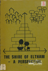
Book, Shire of Eltham, The Shire of Eltham - A Perspective, July 1981
... growth. Characteristics of the population - size and distribution, age / sex, natural increase, migration. Socio-Economic...growth. Characteristics of the population - size and distribution, age / sex, natural increase, migration. Socio-Economic ...This report was produced by the Shire of Eltham (Planning Department) following a population study of the Shire. It also includes other areas of general interest. The Document contents includes Present and Future - Population - Housing - Residential Lands - Social Characteristics - Development and History. Includes maps, tables and diagrams. Part 1: The Existing situation - introduction, the Shire of Eltham, physical characteristics, historical development, population growth. Characteristics of the population - size and distribution, age / sex, natural increase, migration. Socio-Economic Factors: socio-economic status, employment/workforce, education, other social factors. Housing/ building statistics: characteristics of Housing stock, current residential trends, other types of building activity. Residential Land: existing vacant lots, estimated additional lots. Part 2: The Future. Land availability, the future population.The Shire of Eltham Council resolved on publication of this report "to commend it to the ratepayers as a most valuable resource document". It provides a comprehensive statistical review of the Shire of Eltham, Victoria in 1981 with some population and development predictions for the future.Spiral bound, soft cover, includes indexBarcode and identification markings including stamped "WITHDRAWN" from Heidelberg Regional Library Serviceshire of eltham, planning, population -
NMIT (Northern Melbourne Institute of TAFE)
Book: Melbourne’s North – the new knowledge economy Melbourne’s North – the new knowledge economy 2009
... economic zone. The report includes recommendations and benchmarks that will support growth and quality employment outcomes for the region into the future as it undergoes the transition into a knowledge economy. ...economic zone. The report includes recommendations and benchmarks that will support growth and quality employment outcomes for the region into the future as it undergoes the transition into a knowledge economy. ...Melbourne’s North – the new knowledge economy is a study commissioned by NORTH Link and the Northern Metropolitan Melbourne Area Consultative Sub-Committee with seed funding from the Victorian Government Department of Innovation, Industry and Regional Development and matching funding from industry, education and local government in Melbourne’s North. It was prepared by National Institute of Economic and Industry Research. The report provides a detailed analysis of the Melbourne’s North regional economy and builds on the previous report, Growing Melbourne’s North – developing an integrated economy. It concludes that the region can achieve significant economic and social benefits if stakeholders share resources and cooperate across local government boundaries to form a discrete economic zone. The report includes recommendations and benchmarks that will support growth and quality employment outcomes for the region into the future as it undergoes the transition into a knowledge economy. Consultants National Institute of Economic and Industry Research (NIEIR), Carmine Consulting ISBN 978-0-9803994-4-3 northern melbourne region, nmit -
 Monbulk RSL Sub Branch
Book, Penguin Books, The coming of the Third Reich, 2004
... Monbulk RSL Sub Branch 48 Main Road Monbulk yarra-valley-and-the-dandenong-ranges Germany - Politics and government 1933-1939 Germany - Nazi party n 1900, Germany was one of modernity's great success stories: The most progressive and dynamic nation in Europe, it was the only country whose rapid economic growth and innovation rivaled that of the United States. ...n 1900, Germany was one of modernity's great success stories: The most progressive and dynamic nation in Europe, it was the only country whose rapid economic growth and innovation rivaled that of the United States. Its political culture was far less authoritarian than Russia's and less anti-Semitic than France's. Representative institutions thrived, and competing political parties and elections were a central part of life. How, then, could it be that in little more than a generation this stable modern country would fall into the hands of Adolf Hitler and the violent, racist, extremist political movement he led, a movement that would lead Germany and then all of Europe into utter moral, physical, and cultural ruin?" "There is no story in twentieth-century history more important to understand, and Richard Evans has written the definitive account for our time. A masterful synthesis of a vast body of scholarly work integrated with important new research and interpretations, Evans's history restores drama and contingency to the rise to power of Hitler and the Nazis, even as he shows how ready Germany was by the early 1930s for such a takeover to occur. Its citizens were angry and embittered by military defeat and economic ruin, and its young democracy undermined by a civil service, an army, and a law enforcement system deeply alienated from the new order. The electorate was beset by growing extremism and panic about communism; and the small but successful Jewish community was subject to wide-spread suspicion and resentment. In the end, though nothing about what happened was preordained, Germany proved to be fertile ground for Nazism's ideology of hatred.Index, bibliography, ill, maps, p.335.non-fictionn 1900, Germany was one of modernity's great success stories: The most progressive and dynamic nation in Europe, it was the only country whose rapid economic growth and innovation rivaled that of the United States. Its political culture was far less authoritarian than Russia's and less anti-Semitic than France's. Representative institutions thrived, and competing political parties and elections were a central part of life. How, then, could it be that in little more than a generation this stable modern country would fall into the hands of Adolf Hitler and the violent, racist, extremist political movement he led, a movement that would lead Germany and then all of Europe into utter moral, physical, and cultural ruin?" "There is no story in twentieth-century history more important to understand, and Richard Evans has written the definitive account for our time. A masterful synthesis of a vast body of scholarly work integrated with important new research and interpretations, Evans's history restores drama and contingency to the rise to power of Hitler and the Nazis, even as he shows how ready Germany was by the early 1930s for such a takeover to occur. Its citizens were angry and embittered by military defeat and economic ruin, and its young democracy undermined by a civil service, an army, and a law enforcement system deeply alienated from the new order. The electorate was beset by growing extremism and panic about communism; and the small but successful Jewish community was subject to wide-spread suspicion and resentment. In the end, though nothing about what happened was preordained, Germany proved to be fertile ground for Nazism's ideology of hatred.germany - politics and government 1933-1939, germany - nazi party -
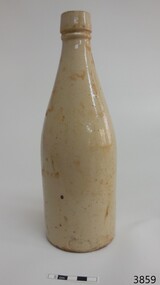 Flagstaff Hill Maritime Museum and Village
Ceramic - Stoneware Bottle, Henry Kennedy Pottery, Late 1800s to early 1900s
... The pottery’s growth to this point was reflected in the eighteen kilns the largest pottery kilns then recorded in Scotland. However, the disruption of the First World War and the combined effects of subsequent economic depression, US prohibition, hygiene regulations and competition from alternative materials posed severe challenges for stoneware potteries in the post-war years as they competed with each other for diminishing markets. ...The pottery’s growth to this point was reflected in the eighteen kilns the largest pottery kilns then recorded in Scotland. However, the disruption of the First World War and the combined effects of subsequent economic depression, US prohibition, hygiene regulations and competition from alternative materials posed severe challenges for stoneware potteries in the post-war years as they competed with each other for diminishing markets. ...This bottle was made in Scotland and recovered decades later from a shipwreck along the coast of Victoria. It may have been amongst the ship's cargo, its provisions or amongst a passenger's personal luggage. It is now part of the John Chance collection. Stoneware bottles similar to this one were in common use during the mid-to-late 19th century. They were used to store and transport. The bottles were handmade using either a potter's wheel or in moulds such as a plaster mould, which gave the bottles uniformity in size and shape. The bottle would then be fired and glazed in a hot kiln. Makers often identified their bottles with the impression of a small symbol or adding a colour to the mouth. The manufacturer usually stamped their bottles with their name and logo, and sometimes a message that the bottle remained their property and should be returned to them. The bottles could then be cleaned and refilled. The Barrowfield pottery was founded in 1866 by Henry Kennedy, an Irish native, in the Camlachie district east of Glasgow, close to the Campbellfield and Mount Blue potteries. It is believed that Kennedy started with just one kiln but by 1871 was employing forty men and six boys and such was the success of the enterprise that by 1880, no less than eight kilns were in operation and a year later one hundred and the pottery was employing eighteen people. Stoneware bottle production was a mainstay of the pottery and over “1500 dozen” were being turned out daily along with other wares, including 30-gallon ironstone containers. With so many kilns in operation, six hundred saggars were required every week but, unlike some potteries, these were made on the premises from Garnkirk and Glenboig fire clays. Pottery production reaches a high scale which presented a high risk of fire and Barrowfield was no exception. In April 1884 heat from a kiln set fire to the roof resulting in significant structural damage, the loss of unfinished wares alone amounting to £10,000 a very substantial sum in 1884. The pottery recovered from this reverse but then Henry Kennedy died in July 1890. The terms of his will indicated that he and his sons John and Joseph were partners and this was reflected in a change of title in the 1891-92 Post Office Directory to Henry Kennedy & Sons. Despite the growth of the business there was still space enough, however, to allow china, earthenware and glass retailers Daniel and John McDougall to commence production of their Nautilus wares there in 1894, the success of which allowed them to soon move to permanent quarters at the empty Saracen Pottery, Possil. In around 1900 John Kennedy left to resurrect the liquidated Cleland Pottery and although Barrowfield remained listed as Henry Kennedy & Sons, brother Joseph was in control. In 1911 Henry Kennedy & Sons Ltd was formed, with two of the four directors being the Kennedy brothers. The pottery’s growth to this point was reflected in the eighteen kilns the largest pottery kilns then recorded in Scotland. However, the disruption of the First World War and the combined effects of subsequent economic depression, US prohibition, hygiene regulations and competition from alternative materials posed severe challenges for stoneware potteries in the post-war years as they competed with each other for diminishing markets. Competitors such as Eagle and Caledonian Potteries fell by the wayside and finally, Barrowfield closed in 1929. This stoneware bottle is historically significant for its manufacture and use in the late 19th to the early 20th century. The bottle is also significant as it was recovered by John Chance, a diver, from a wreck on the coast of Victoria in the 1960s-70s. Items that come from several wrecks along Victoria's coast have since been donated to the Flagstaff Hill Maritime Village’s museum collection by his family, illustrating this item’s level of historical value. Stoneware was produced at Barrowfield pottery for the domestic and export markets, with South America being a large market. Barrowfield stoneware can be found throughout the world. Its longevity and abundant production makes the subject item a significant addition to the Flagstaff Hill Maritime Museum collection.Bottle, salt glazed stoneware, beige, some discolouration above base. Chip on base and on neck. Inscriptions stamped near base.Makers lozenge stamped, H Kennedy Barrowfield Pottery GLASGOW at base.flagstaff hill, warrnambool, flagstaff hill maritime museum, maritime museum, shipwreck coast, flagstaff hill maritime village, great ocean road, john chance, h kennedy pottery, stoneware, ironstone, pottery, barrowfield glasgow -
 Flagstaff Hill Maritime Museum and Village
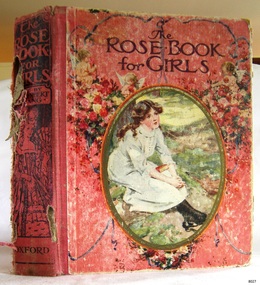
Book - Fiction, Mrs Herbert Strang, editor, The Rose Book for Girls, 1916
... In addition, the book is notable for its connection to the McCullagh family, a prominent farming family whose contributions supported the social and economic growth of the local district. This historical association enriches its value, situating the book within the broader narrative of community progress and pioneer achievement in the area, and highlighting its place within a tradition of religious life and community building. ...Alma McCullagh was a student at the Presbyterian Sabbath School located in Dennington, near Warrnambool. In January, around 1928, she received a book as an award from R. Conn, her Sabbath School teacher, in recognition of her involvement and achievements at the school. The exact year of this award is based on available records: in January 1928, Alma was presented with a prize by R. Conn, whereas by 1930, the role of awarding prizes had passed to F. Jones. Alma was probably the granddaughter of James McCullagh (1831–1911) and Elizabeth Eccles (1831–1909), who were pioneering settlers in the region. James and Elizabeth married in 1856 and established their home at Oak Grove, Yangery, Illowa from 1859, residing there until their deaths. One of their sons, William McCullagh (1873–1940), married Margaret Jane Russell (1879–1981). William and Margaret continued the family tradition, making their home at Oak Grove as well. They raised eleven children, with Alma likely being among the youngest of their children.The book, “The Rose Book for Girls”, edited by Mrs Herbert Strang, represents an example of literature accessible to older girls during the early 20th century. It was specifically selected as an end-of-year award, recognising consistent attendance at Sabbath School. Such choices highlight the role of books in supporting the educational and moral development of young women during this period. The book is important as a connection to the early township of Dennington, a community distinguished by its established school and church. This association reflects the values the community placed on education and religious instruction. The book’s significance is further enhanced by its relationship with colonial pioneer families in Australia, particularly those from Victoria and the Warrnambool district in southwest Victoria. It is a tangible link to the history and legacy of these early settlers, who were instrumental in shaping the regional development. In addition, the book is notable for its connection to the McCullagh family, a prominent farming family whose contributions supported the social and economic growth of the local district. This historical association enriches its value, situating the book within the broader narrative of community progress and pioneer achievement in the area, and highlighting its place within a tradition of religious life and community building.The Rose Book for Girls A collection of short stories by various authors Edited by Mrs Herbert Strang Publisher: Henry Frowde, Hodder & Stoughton, London Printer: Morrison & Gibb Ltd., Tanfield, Edinburgh, Scotland, UK Date: 1916 Hardcover book. Deep pink front and back covers, decorated with garlands of pink and white flowers, cupids and blue ribbons. The front has a cameo with a seated girl in white, with a book in her lap. Details on the spine: title, author, publisher and a sketched female in 19th-century dress holding a fan. The fly page shows details of the book and has a black and red sketch of two seated girls, one reading, the other stitching. Twenty-five books are listed on the Contents page, as well as the printer's details. Within the book are several colourful sketches. Inscriptions include the name of the book's previous owner, Alma McCullagh.Front loose-end paper: "Presbyterian Sabbath School, Dennington. Prize Awarded to: Alma McCullagh. January. (year is unreadable, circa 1928) R. Conn, Teacher"flagstaff hill, flagstaff hill maritime museum and village, warrnambool, maritime museum, maritime village, great ocean road, shipwreck coast, book, the rose book for girls, mrs herbert strang, short stories, henry frowde, hodder & stoughton, london, morrison & gibb ltd, 1916, alma mccullagh, james mccullagh, elizabeth eccles mccullagh, ca. 1928, dennington, southwest victoria, warrnambool district, presbyterian sabbath school, presbyterian sunday school, dennington presbyterian church, book award, book prize, book presentation, r. conn, sabbath school superintendent -
 Flagstaff Hill Maritime Museum and Village
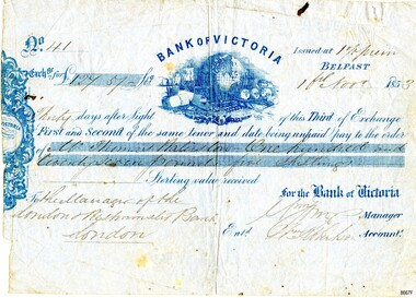
Currency - Banknote Belfast, Bank of Victoria, 1853
... This promissory note records the early colonial system of banking and reflects the economic growth and entrepreneurship of the South West Region of Victoria. ...The promissory note issued at Belfast, now Port Fairy, Victoria by the “Bank of Victoria” is an early example of currency issued by a private bank. This note was issued in 1853 the same year that the bank commenced business in Belfast. Details of the first production of a banknote backed by the Australian Government occurred on 1 May 1913 following the "Australian Notes Act of 1910" (Australian National Museum). The first building the Bank of Victoria purchased in Belfast was of timber and later sold. Smith & Watts Architects advertised for tenders in the Melbourne Argus on Thursday 29/4/1869 for the erection of a substantial building that is now occupied by Moyne Shire Council in Cox Street. A meeting of the Directors of the Bank of Victoria elected on 1 October 1852. A ballot took place for four directors resulting in Wm. Highett Esq. Wm F. Splatt, Esq. M.L.C., Alex. Wilson, Esq. and W.H. Tuckett” elected as Directors. It was reported from a later meeting in “The Argus” Melbourne on 3 August 1853 that a branch had opened in Swanston Street, Melbourne on 3rd January 1852 with Henry Miller as Chairman of the Board and J. Matheson as the Manager; followed by Geelong on 12 August 1852. Then at the request of “influential inhabitants”, the Belfast branch commenced on 11 May 1853, which had “already met with very general support and encouragement”. This was a colonial bank at the time of vast pastoral runs and gold speculation – how "Mr Thomas [....ton?]" came by his fortune of One Hundred and Twenty-Seven Pound and five shillings can only be wondered at until further research reveals the story. This promissory note records the early colonial system of banking and reflects the economic growth and entrepreneurship of the South West Region of Victoria.Banknote of fine paper. There is a fold multi-crease down the centre top to bottom, lighter creasing across the top and angular creasing to the bottom left and right-hand corners. Yellow spotting is visible across the object breaking through the grey blue colour of the paper. A dark ink blot appears near the top right-hand corner. The left-hand side of the banknote is uneven. The back of the document has darker spotting, a used dirty look patina and some insect spotting. Horizontal crease markings can be seen creating quarter marks. The front of the banknote reads: "No.41/ Exch.ge for £127.57- Bank of Victoria/Issued at 1% prem/Thirty days after Sight of this Third of Exchange/First and Second of the same tenor and date being unpaid pay to the order of/Mr. Thomas [Raliston?]/One hundred and twenty seven pounds five shillings Sterling silver received/To the Manager of the London Westminister Bank London/for the Bank of Victoria [signed?] Manager/Ent.d [?] Robertson Account.t. The blue printed Bank of Victoria logo features a world globe, sailing ships, wool bails, sheep, colonial building and mining tools. flagstaff hill, warrnambool, maritime village, maritime museum, flagstaff hill maritime museum and village, shipwreck coast, great ocean road, promissory notes, bank notes, bank of victoria, smith & watts, smith & watts architects, 1853, william highett, william f. splatt, alex wilson, w.h. tuckett, henry miller, money miller, belfast (now port fairy), banknote -
Broadmeadows Historical Society & Museum
Document - Municipal Overview, Broadmeadows Municipal and Industrial Profile, mid-20th century
... Broadmeadows Historical Society & Museum 21 Pearcedale Parade Broadmeadows melbourne This document reflects the historical growth of Broadmeadows from its proclamation in the mid 19th century through to significant industrial expansion in the mid 20th century, documenting key employers and urban development trends. The document is significant as a consolidated historical reference that documents the expansion of Broadmeadows, particularly its industrial base, contributing to an understanding of local economic and social development. ...This document reflects the historical growth of Broadmeadows from its proclamation in the mid 19th century through to significant industrial expansion in the mid 20th century, documenting key employers and urban development trends.The document is significant as a consolidated historical reference that documents the expansion of Broadmeadows, particularly its industrial base, contributing to an understanding of local economic and social development.Printed paper document, single sheet.Printed text throughout document. Handwritten inscriptions visible.broadmeadows (vic.), municipal history, industrial development, urban growth, local government, city of broadmeadows, 1880-1981 -
Broadmeadows Historical Society & Museum
Photograph - Group Photo, Classic Studios Victoria, Jacana Primary School - Students and Staff Photograph, 2006, 2006
... growth, and government housing programs. Over the decades, Jacana Primary evolved alongside its community, reflecting the changing social and cultural landscape of the area. By the 1990s and early 2000s, the school had become a vibrant and inclusive environment, welcoming students from a wide range of cultural and socio-economic backgrounds. ...growth, and housing expansion. This photograph reflects the school’s enduring commitment to inclusion, diversity, and community engagement. By the early 2000s, Jacana Primary had become a vibrant educational environment, welcoming students and staff from a wide range of cultural and socio-economic backgrounds. ...Jacana Primary School was established in 1959 during a period of rapid suburban expansion in Melbourne’s northern corridor. Situated in the suburb of Jacana, the school was part of a broader post-war initiative aimed at delivering accessible public education to communities shaped by migration, industrial growth, and government housing programs. Over the decades, Jacana Primary evolved alongside its community, reflecting the changing social and cultural landscape of the area. By the 1990s and early 2000s, the school had become a vibrant and inclusive environment, welcoming students from a wide range of cultural and socio-economic backgrounds. This diversity was embraced through inclusive teaching practices, multicultural celebrations, and student leadership initiatives such as the junior student council. The 2006 photograph captures a moment near the end of the school’s operation, showcasing the unity and shared purpose of its students and staff. It highlights the school’s role not only as a place of learning but also as a centre for community building, civic engagement, and social support. Although Jacana Primary School closed in the early 2000s, its legacy endures through archival materials like this photograph. These records offer valuable insights into the role of public education in shaping community identity and fostering social cohesion during a transformative period in Melbourne’s suburban history. The 2006 Students and Staff photograph from Jacana Primary School is a historically significant visual record that captures the final chapter of a school deeply embedded in Melbourne’s northern suburban landscape. Established in 1959 during a wave of post-war development, Jacana Primary was part of a broader initiative to provide accessible public education to communities shaped by migration, industrial growth, and housing expansion. This photograph reflects the school’s enduring commitment to inclusion, diversity, and community engagement. By the early 2000s, Jacana Primary had become a vibrant educational environment, welcoming students and staff from a wide range of cultural and socio-economic backgrounds. The image documents the collaborative spirit and shared purpose that defined the school’s ethos, highlighting its role as both a learning institution and a centre of social cohesion. As one of the final visual records before the school’s closure, the photograph holds particular significance. It offers insight into the lived experiences of students and educators during a transformative period in Melbourne’s suburban history and stands as a testament to the lasting impact of public education in fostering community identity and resilience.A colour photograph mounted on matte Paper with a purple border(Blue Label) PH - 5383 Classic Studios VIC order: p337249 / Frame x Jacana whole school item 4 Kodak Professional / Endura Paper. papier. papel / Professional images are/ copyright protected / Dutch copyright Gerschütz jacana primary school, education, photograph, group photograph, 2006, students and staff, jacana -
 Kew Historical Society Inc
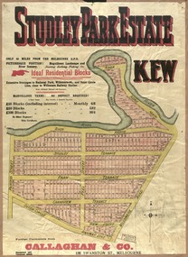
Plan, Studley Park Estate, 1910
... An obvious starting point for Sanderson’s groupings involved population growth and the associated economic cycles. These cycles also highlighted urban expansion onto land that was predominantly rural, although in other cases it represented the decline and breakup of large estates. ...An obvious starting point for Sanderson’s groupings involved population growth and the associated economic cycles. These cycles also highlighted urban expansion onto land that was predominantly rural, although in other cases it represented the decline and breakup of large estates. ...Prue Sanderson, in her groundbreaking ‘City of Kew Urban Conservation Study : Volume 2 - Development History’ (1988), summarised the periods of urban development and subdivisions of land in Kew. The periods that she identified included 1845-1880, 1880-1893, 1893-1921, 1921-1933, 1933-1943, and Post-War Development. These periods were selected as they represented periods of rapid growth or decline in urban development. An obvious starting point for Sanderson’s groupings involved population growth and the associated economic cycles. These cycles also highlighted urban expansion onto land that was predominantly rural, although in other cases it represented the decline and breakup of large estates. A number of the plans in the Kew Historical Society’s collection can also be found in other collections, such as those of the State Library of Victoria and the Boroondara Library Service. A number are however unique to the collection.The Kew Historical Society collection includes almost 100 subdivision plans pertaining to suburbs of the City of Melbourne. Most of these are of Kew, Kew East or Studley Park, although a smaller number are plans of Camberwell, Deepdene, Balwyn and Hawthorn. It is believed that the majority of the plans were gifted to the Society by persons connected with the real estate firm - J. R. Mathers and McMillan, 136 Cotham Road, Kew. The Plans in the collection are rarely in pristine form, being working plans on which the agent would write notes and record lots sold and the prices of these. The subdivision plans are historically significant examples of the growth of urban Melbourne from the beginning of the 20th Century up until the 1980s. A number of the plans are double-sided and often include a photograph on the reverse. A number of the latter are by noted photographers such as J.E. Barnes.Coloured lithograph of a subdivision plan of the Studley Park Estate, bordered by Yarra, Willsmere Road and the Outer Circle Railway line. The estate was listed in 1910 and was the subject of a planning dispute between the developer and the Town of Kew in relation to flood levels and the suitability of the land for housing. In many cases the names of streets were subsequently changed. The layout was also affected by the creation of the Eastern Freeway. A newspaper report of the day described the subdivision as a: "GOLDEN OPPORTUNITY. We are pleased to submit for PRIVATE SALE that magnificent ESTATE, situated only 4 1/2 miles from the Melbourne General Post Office, STUDLEY PARK ESTATE. KF/NV. Doubtless the CHEAPEST LAND EVER OFFERED having extensive frontages to the prettiest spot on the River Yarra and the National Park, commanding lovely river and landscape views, and acknowledged to be the finest land available so close to the city. The PRICES ARE EXTREMELY MODERATE; The TERMS ARE SIMPLY MARVELLOUS. NO DEPOSIT. NO DEPOSIT. NO DEPOSIT. Allotments and prices to suit everyone."subdivision plans - kew, studley park estate -
 Kew Historical Society Inc
Plan, Studley Heights Estate, 1936
... An obvious starting point for Sanderson’s groupings involved population growth and the associated economic cycles. These cycles also highlighted urban expansion onto land that was predominantly rural, although in other cases it represented the decline and breakup of large estates. ...An obvious starting point for Sanderson’s groupings involved population growth and the associated economic cycles. These cycles also highlighted urban expansion onto land that was predominantly rural, although in other cases it represented the decline and breakup of large estates. ...Pru Sanderson, in her groundbreaking ‘City of Kew Urban Conservation Study : Volume 2 - Development History’ (1988), summarised the periods of urban development and subdivisions of land in Kew. The periods that she identified included 1845-1880, 1880-1893, 1893-1921, 1921-1933, 1933-1943, and Post-War Development. These periods were selected as they represented periods of rapid growth or decline in urban development. An obvious starting point for Sanderson’s groupings involved population growth and the associated economic cycles. These cycles also highlighted urban expansion onto land that was predominantly rural, although in other cases it represented the decline and breakup of large estates. A number of the plans in the Kew Historical Society’s collection can also be found in other collections, such as those of the State Library of Victoria and the Boroondara Library Service. A number are however unique to the collection.Subdivision plans are historically important documents used as evidence of the growth of suburbs in Australia. They frequently provide information about when the land was sold on which a built structure was subsequently constructed as well as evidence relating to surveyors and real estate and financial agents. The numerous subdivision plans in the Kew Historical Society's collection represent working documents, ranging from the initial sketches made in planning a subdivision to printed plans on which auctioneers or agents listed the prices for which individual lots were sold. In a number of cases, the reverse of a subdivision plan in the collection includes a photograph of a house that was also for sale by the agent. These photographs provide significant heritage information relating house design and decoration, fencing and household gardens.The ‘Studley Heights Estate’ on the South Side of Studley Park Road was launched in 1936. The seventeen allotments in the subdivision fronted Hyton Crescent and Studley Park Road.subdivision plans - kew, studley heights estate -
![Monnington [Estate], 1935](/media/collectors/550653872162f11fb04854aa/items/5907eb86d0ce0c14e82385c8/item-media/5907ecafd0ce0c14e823e87f/item-fit-380x285.jpg?cb=6) Kew Historical Society Inc
Kew Historical Society IncPlan - Subdivision Plan, Monnington [Estate], 1935, 1935
... An obvious starting point for Sanderson’s groupings involved population growth and the associated economic cycles. These cycles also highlighted urban expansion onto land that was predominantly rural, although in other cases it represented the decline and breakup of large estates. ...An obvious starting point for Sanderson’s groupings involved population growth and the associated economic cycles. These cycles also highlighted urban expansion onto land that was predominantly rural, although in other cases it represented the decline and breakup of large estates. ...Pru Sanderson, in her groundbreaking ‘City of Kew Urban Conservation Study : Volume 2 - Development History’ (1988), summarised the periods of urban development and subdivisions of land in Kew. The periods that she identified included 1845-1880, 1880-1893, 1893-1921, 1921-1933, 1933-1943, and Post-War Development. These periods were selected as they represented periods of rapid growth or decline in urban development. An obvious starting point for Sanderson’s groupings involved population growth and the associated economic cycles. These cycles also highlighted urban expansion onto land that was predominantly rural, although in other cases it represented the decline and breakup of large estates. A number of the plans in the Kew Historical Society’s collection can also be found in other collections, such as those of the State Library of Victoria and the Boroondara Library Service. A number are however unique to the collection.Subdivision plans are historically important documents used as evidence of the growth of suburbs in Australia. They frequently provide information about when the land was sold on which a built structure was subsequently constructed as well as evidence relating to surveyors and real estate and financial agents. The numerous subdivision plans in the Kew Historical Society's collection represent working documents, ranging from the initial sketches made in planning a subdivision to printed plans on which auctioneers or agents listed the prices for which individual lots were sold. In a number of cases, the reverse of a subdivision plan in the collection includes a photograph of a house that was also for sale by the agent. These photographs provide significant heritage information relating house design and decoration, fencing and household gardens.The first subdivision of Monnington took place in 1935. At that time, Monnington and 10 new allotments were offered for sale bordering Adeney and Marshall Avenues. In this subdivision plan, Monnington is one of 13 lots for sale. The subdivision created the irregular land holding of Monnington today. The excision of southwest corner of Monninton was caused by the need to have regular allotments facing the curve in Marshall Avenue.monnington - adeney avenue -- kew (vic.), subdivision plans -- kew (vic.) -
 Kew Historical Society Inc
Plan - Subdivision Plan, Goldthorns House Estate, 1940
... An obvious starting point for Sanderson’s groupings involved population growth and the associated economic cycles. These cycles also highlighted urban expansion onto land that was predominantly rural, although in other cases it represented the decline and breakup of large estates. ...An obvious starting point for Sanderson’s groupings involved population growth and the associated economic cycles. These cycles also highlighted urban expansion onto land that was predominantly rural, although in other cases it represented the decline and breakup of large estates. ...Pru Sanderson, in her groundbreaking ‘City of Kew Urban Conservation Study : Volume 2 - Development History’ (1988), summarised the periods of urban development and subdivisions of land in Kew. The periods that she identified included 1845-1880, 1880-1893, 1893-1921, 1921-1933, 1933-1943, and Post-War Development. These periods were selected as they represented periods of rapid growth or decline in urban development. An obvious starting point for Sanderson’s groupings involved population growth and the associated economic cycles. These cycles also highlighted urban expansion onto land that was predominantly rural, although in other cases it represented the decline and breakup of large estates. A number of the plans in the Kew Historical Society’s collection can also be found in other collections, such as those of the State Library of Victoria and the Boroondara Library Service. A number are however unique to the collection.The Kew Historical Society collection includes almost 100 subdivision plans pertaining to suburbs of the City of Melbourne. Most of these are of Kew, Kew East or Studley Park, although a smaller number are plans of Camberwell, Deepdene, Balwyn and Hawthorn. It is believed that the majority of the plans were gifted to the Society by persons connected with the real estate firm - J. R. Mathers and McMillan, 136 Cotham Road, Kew. The Plans in the collection are rarely in pristine form, being working plans on which the agent would write notes and record lots sold and the prices of these. The subdivision plans are historically significant examples of the growth of urban Melbourne from the beginning of the 20th Century up until the 1980s. A number of the plans are double-sided and often include a photograph on the reverse. A number of the latter are by noted photographers such as J.E. Barnes.The first subdivision of Goldthorns created the Goldthorns Hill Estate. Following that subdivision, seven additional lots were offered between Normanby Road, Argyle Road and Lady Loch’s Drive on the proviso that the estate, including Goldthorns was not sold as a single lot. The subdivision plan advises that the lots are situated in one of the most charming and popular residential areas in Kew and is surrounded by modern homes. Typically, the subdivision plan proposes the advantage of its proximity to Cotham Road and the tram to Collins Street. Because of the elevation of Goldthorns, much is made of the ‘bright, sunny and extensive outlook to the Northern Ranges’ and that it overlooks the Yarra Valley. One of the more interesting aspects of the plan is that it shows the outline of Goldthorns in the mid to late 1920s. Its profile today remains virtually the same."Goldthorns" House Estate at topsubdivision plans - kew, goldthorns house estate