Showing 329 items matching " excavations"
-
 Ringwood and District Historical Society
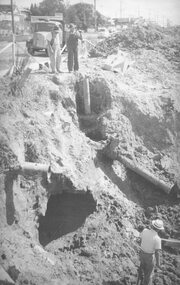
Photograph, Maroondah Highway East, Ringwood- 963. Excavations for Ringwood Lake overflow
... Maroondah Highway East, Ringwood- 963. Excavations for Ringwood Lake overflow....Written on rear of backing sheet, "Excavations for Ringwood Lake overflow- 1963."...Black and white photograph (2 copies- 1 large, 1 smaller) Maroondah Highway East, Ringwood- 963. Excavations for Ringwood Lake overflow. Photograph ...Black and white photograph (2 copies- 1 large, 1 smaller)Written on rear of backing sheet, "Excavations for Ringwood Lake overflow- 1963." -
 Ringwood and District Historical Society
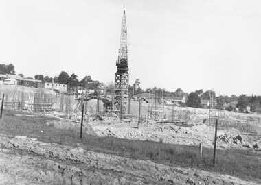
Photograph, Excavations for Maroondah Hospital - 1973
... Excavations for Maroondah Hospital - 1973....Typed below photograph, "Excavations for Maroondah Hospital" and written on backing sheet, "1973"....Excavations for Maroondah Hospital - 1973. Photograph ...Typed below photograph, "Excavations for Maroondah Hospital" and written on backing sheet, "1973". -
 Ringwood and District Historical Society
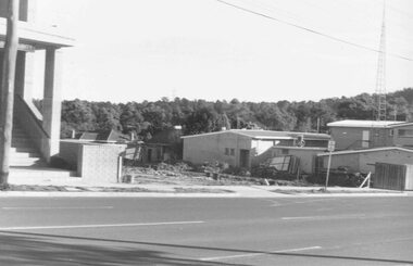
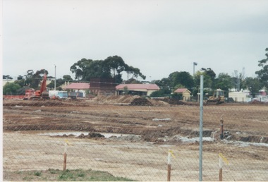
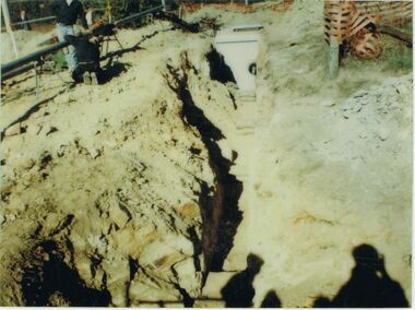
Photograph, Ringwood Street Ringwood. The excavations preparing for buildings next to social security buildings. 1981
... Ringwood Street Ringwood. The excavations preparing for buildings next to social security buildings. 1981...Ringwood St. The excavations preparing for buildings next to social security buildings....Ringwood St. The excavations preparing for buildings next to social security buildings. ...Written on back of photograph, "30/6/81. Ringwood St. The excavations preparing for buildings next to social security buildings. -
 Wodonga & District Historical Society Inc
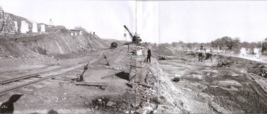
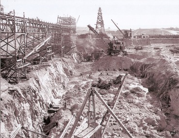
Album - Hume Reservoir Australia Album - Excavations for foundations of spillway, September 1921
... Hume Reservoir Australia Album - Excavations for foundations of spillway, September 1921....HUME RESERVOIR. 6. Excavation in progress for foundations of outlet and spillway sections of dam. ...Hume Reservoir Australia Album - Excavations for foundations of spillway, September 1921. ...This set of photos is from a leather bound album bearing the inscription "HUME RESERVOIR AUSTRALIA" plus 'The Rt. Hon. L. C. M. S. Amery, P. C., M .P.' all inscribed in gold. It was presented to The Rt. Hon. L. C. M. S. Amery, P. C., M. P, Secretary of State for Dominion Affairs on the occasion of his visit to the Hume Reservoir on 2nd November 1927. This album is of local and national significance as it documents the planning and development of the Hume Reservoir up to 1927. It was the largest water reservoir in the British Empire. The album records the pioneering engineering work that went into its construction.DEPARTMENT OF PUBLIC WORKS, N.S.W. RIVER MURRAY WATERS SCHEME. HUME RESERVOIR. 6. Excavation in progress for foundations of outlet and spillway sections of dam. September 1921.hume reservoir australia, river murray waters scheme, hume weir diagrams, hume plan details -
 Wodonga & District Historical Society Inc
Album - Hume Reservoir Australia Album - Excavations for foundations inside coffer dam, January 1927
... Hume Reservoir Australia Album - Excavations for foundations inside coffer dam, January 1927...HUME RESERVOIR. 21. Excavations for foundations inside coffer dam. ...HUME RESERVOIR. 21. Excavations for foundations inside coffer dam. ...This set of photos is from a leather bound album bearing the inscription "HUME RESERVOIR AUSTRALIA" plus 'The Rt. Hon. L. C. M. S. Amery, P. C., M .P.' all inscribed in gold. It was presented to The Rt. Hon. L. C. M. S. Amery, P. C., M. P, Secretary of State for Dominion Affairs on the occasion of his visit to the Hume Reservoir on 2nd November 1927. This album is of local and national significance as it documents the planning and development of the Hume Reservoir up to 1927. It was the largest water reservoir in the British Empire. The album records the pioneering engineering work that went into its construction.DEPARTMENT OF PUBLIC WORKS, N.S.W. RIVER MURRAY WATERS SCHEME. HUME RESERVOIR. 21. Excavations for foundations inside coffer dam. New South Wales. January 1927. Cofferdams are temporary structures used where construction is being carried out in areas submerged in water. They are most commonly used to facilitate the construction or repair of dams, piers and bridges. To divert the river, a Coffer Dam was built across the old bed above and below the Dam site and tying into the end of the concrete wall built inside the levee bank. This completely surrounded the remainder of the site of the Dam and south wing wall, including an area of 12½ acres. hume reservoir australia, river murray waters scheme, hume reservoir construction, coffer dam -
 Ringwood and District Historical Society
Photograph, Maroondah Highway East, Ringwood. Excavations for Ringwood Lake overflow, 1963
... Maroondah Highway East, Ringwood. Excavations for Ringwood Lake overflow, 1963....Black and white photograph (3 copies- 2 large, 1 small) Maroondah Highway East, Ringwood. Excavations for Ringwood Lake overflow, 1963. ...Black and white photograph (3 copies- 2 large, 1 small)Written below one photograph: "Ringwood Lake overflow pipe (under Maroondah Highway) - 1963". Typed below a similar image: "Overflow from Ringwood Lake- 1963." -
 Ringwood and District Historical Society
Photograph, Maroondah Highway East, Ringwood- 1963. Excavations for Ringwood Lake overflow
... Maroondah Highway East, Ringwood- 1963. Excavations for Ringwood Lake overflow. ...Black and white photograph (2 copies- 1 large, 1 smaller) Maroondah Highway East, Ringwood- 1963. Excavations for Ringwood Lake overflow. Photograph ...Black and white photograph (2 copies- 1 large, 1 smaller)Typed on rear of backing sheet of large photograph: "Ringwood lake overflow pipe. (Passing under Maroondah Highway). 1963. -
 Nillumbik Historical Society Incorporated
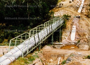
Photograph - Colour photograph, Aqueduct Excavations and Pipeline over Plenty River
... Aqueduct Excavations and Pipeline over Plenty River...Nillumbik Historical Society Incorporated 10 Nillumbik Square Diamond Creek melbourne diamond creek state school diamond creek nillumbik school Colour photograph Aqueduct Excavations and Pipeline over Plenty River Photograph Colour photograph ...Colour photographdiamond creek state school, diamond creek, nillumbik school -
 Bendigo Art Gallery
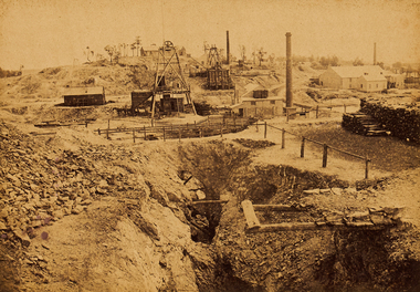
Photograph - Work on paper, Nicholas CAIRE, View of North Old Chum Claim, showing surface Excavations, 1875
... View of North Old Chum Claim, showing surface Excavations...View of North Old Chum Claim, showing surface Excavations Photograph Work on paper Nicholas CAIRE ...Inscribed on original mountcard, l.l., gold letterpress, "N.J. CAIRE". Not dated.albumen, photograph, bendigo, sandhurst, regional victoria, goldfields, township, city -
 Villa Alba Museum
Document, Villa Alba Museum Archaeological Test Excavations, 2002
... Villa Alba Museum Archaeological Test Excavations...Villa Alba Museum Archaeological Test Excavations Document ...A preliminary report on archaeological test excavations, conducted on 5 & 7 September 2002 by Maddy Atkinson (Ripple Arc). The purpose of the excavations was twofold. Firstly, to conduct subsurface testing at Villa Alba to determine the presence, location and depth below ground of archaeological remains relating to a number of landscape features identified in historical plans, photographs, survey field books and aerial photographs. Secondly, soils surrounding the Villa Alba mansion, which have been found to be contaminated with lead will need to be removed up to a depth of up to 0.6 metres. Removal of deposits from the site may have an adverse impact on any archaeological remains existing below the surface.Contents: Acknowledgements / Abbreviations / List of figures / List of tables / List of plates / Introduction / Historical context / Methodology / Results and interpretations / Discussion / Recommendations / References / Appendix 1 - Plates / Appendix 2 - Content list / Appendix 3 - Copy of Heritage Victoria permit.non-fictionA preliminary report on archaeological test excavations, conducted on 5 & 7 September 2002 by Maddy Atkinson (Ripple Arc). The purpose of the excavations was twofold. Firstly, to conduct subsurface testing at Villa Alba to determine the presence, location and depth below ground of archaeological remains relating to a number of landscape features identified in historical plans, photographs, survey field books and aerial photographs. Secondly, soils surrounding the Villa Alba mansion, which have been found to be contaminated with lead will need to be removed up to a depth of up to 0.6 metres. Removal of deposits from the site may have an adverse impact on any archaeological remains existing below the surface. conservation studies, conservation reports, archaeological reports, villa alba museum -
Villa Alba Museum
Document, Maddy Maitri (Maitri Archaeology), Villa Alba Landscape Reconstruction: Archaeological Test Excavations Phase 2, 2002
... Villa Alba Landscape Reconstruction: Archaeological Test Excavations Phase 2...Villa Alba Landscape Reconstruction: Archaeological Test Excavations Phase 2 Document Maddy Maitri (Maitri Archaeology) ...This document documents the results of archaeological excavations conducted within the grounds of Villa Alba in Kew, by Maddy Maitri (Maitri Archaeology) in October 2002. The testing was conducted as part of the design development stage of a proposed landscape reconstruction. The broad aim of subsurface testing at Villa Alba was to determine the presence, location and depth below ground of archaeological remains relating to a number of landscape features identified in historical plans, photographs, survey field books and aerial photographs. This information would then be used by the landscape architect in the development of a design which approximates the 1880s/1890s landscape of Villa Alba.Contents: Acknowledgements / Abbreviations / List of figures / List of tables / List of plates / Introduction / Historical context / Methodology / Results and interpretations / Discussion / Recommendations / References / Appendix 1 - Plates / Appendix 2 - Content list / Appendix 3 - Copy of Heritage Victoria permit. This document documents the results of archaeological excavations conducted within the grounds of Villa Alba in Kew, by Maddy Maitri (Maitri Archaeology) in October 2002. The testing was conducted as part of the design development stage of a proposed landscape reconstruction. The broad aim of subsurface testing at Villa Alba was to determine the presence, location and depth below ground of archaeological remains relating to a number of landscape features identified in historical plans, photographs, survey field books and aerial photographs. This information would then be used by the landscape architect in the development of a design which approximates the 1880s/1890s landscape of Villa Alba.villa alba - archaeology, villa alba - garden reconstruction, 2002 -
Villa Alba Museum
Document, Maddy Atkinson (Ripple Arc), Villa Alba Museum Landscape Reconstruction Archaeological Test Excavations, 2002
... Villa Alba Museum Landscape Reconstruction Archaeological Test Excavations...Villa Alba Museum Landscape Reconstruction Archaeological Test Excavations Document Maddy Atkinson (Ripple Arc) ...This report documents the results of archaeological test excavations conducted within the grounds of Villa Alba in Kew. Archaeological testing was commissioned by the Villa Alba Museum Management Committee as part of the design development stage of a proposed landscape reconstruction. The project was directed by Maddy Atkinson in consultation with Jeremy Smith (Heritage Victoria) and James Broadbent (landscape architect for VAMI Inc). The field team consisted of undergraduates and graduate volunteers from La Trobe University, Monash University, the University of Melbourne and Holmesglen TAFE. Archaeological testing took place on Monday 8th April and Wednesday 10th 2002.Contents: Acknowledgements / Abbreviations / List of figures / List of tables / List of plates / Introduction / Historical context / Methodology / Results and interpretations / Discussion / Recommendations / References / Appendix 1 - Plates / Appendix 2 - Content list / Appendix 3 - Copy of Heritage Victoria permit.non-fictionThis report documents the results of archaeological test excavations conducted within the grounds of Villa Alba in Kew. Archaeological testing was commissioned by the Villa Alba Museum Management Committee as part of the design development stage of a proposed landscape reconstruction. The project was directed by Maddy Atkinson in consultation with Jeremy Smith (Heritage Victoria) and James Broadbent (landscape architect for VAMI Inc). The field team consisted of undergraduates and graduate volunteers from La Trobe University, Monash University, the University of Melbourne and Holmesglen TAFE. Archaeological testing took place on Monday 8th April and Wednesday 10th 2002.villa alba - archaeology, villa alba - garden reconstruction, 2002 -
 Kiewa Valley Historical Society
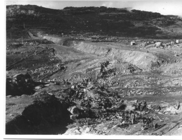
Photograph of Rocky Valley, Rocky Valley showing Dam Excavation, c1948-1951
... Rocky Valley showing Dam Excavation...A black and white photograph showing the excavation of the dam at Rocky Valley looking towards Heathey's Spur...Hand written on the back of photograph in blue ink "Rocky Valley showing dam excavation" ...Shows the extent of the project undertaken and the fact that a lot of the work was done manually by pick and shovel - note the workmen using picks and sledge hammers on the lower half of the photo. rocky valley dam wall picks sledge hammers Hand written on the back of photograph in blue ink "Rocky Valley showing dam excavation" A black and white photograph showing the excavation of the dam at Rocky Valley looking towards Heathey's Spur Rocky Valley showing Dam Excavation Photograph of Rocky Valley Photograph probably taken by Mr. ...This photograph was taken during construction of the Rocky Valley Dam and wall. Work was commenced in early 1947 but had to be suspended during winter and then resumed in October. Work continued in 1948 with the establishment of work facilities and, at the dam site, the river was diverted through a temporary pipeline. Rocky Valley and associated spillway and outlet works were completed in 1959.A pictorial record of the construction of the rock and earth filled dam wall at Rocky Valley. Shows the extent of the project undertaken and the fact that a lot of the work was done manually by pick and shovel - note the workmen using picks and sledge hammers on the lower half of the photo.A black and white photograph showing the excavation of the dam at Rocky Valley looking towards Heathey's SpurHand written on the back of photograph in blue ink "Rocky Valley showing dam excavation" rocky valley, dam, wall, picks, sledge hammers -
Tatura Irrigation & Wartime Camps Museum
Photograph, Goulburn Waranga Main Channel Construction, 1957
... Large black and white photograph - dry mounted to cream board. Channel excavation scene - with excavator operating in mid distance, tractor with rooter in foreground....Below photo: "Goulburn Waranga Main Channel Construction / Channel excavation in progress / 200 W. Bucyrus Dragline, D.8 Caterpillar Tractor with rooter with "Gradall"...Channel excavation scene - with excavator operating in mid distance, tractor with rooter in foreground. ...Photo taken by the photographer for Victoria State Rivers and Water Supply Commission of the Goulburn Waranga main channel in 1957.Large black and white photograph - dry mounted to cream board. Channel excavation scene - with excavator operating in mid distance, tractor with rooter in foreground.Below photo: "Goulburn Waranga Main Channel Construction / Channel excavation in progress / 200 W. Bucyrus Dragline, D.8 Caterpillar Tractor with rooter with "Gradall"goulburn, waranga, irrigation, photo, victoria state rivers and water supply commission -
 Stawell Historical Society Inc
Photograph, Davis Open Cut Stawell showing the uncovered 19th Century shaft
... Davis Open Cut Stawell showing 19th Century shaft uncovered by recent excavations by Western Mining....Black and white photograph of a mining scene. a open excavation - featuring a open hole in the bank. ...Stawell Historical Society Inc 46 Longfield St Stawell grampians Davis Open Cut Stawell showing 19th Century shaft uncovered by recent excavations by Western Mining. stawell mining Black and white photograph of a mining scene. a open excavation - featuring a open hole in the bank. ...Davis Open Cut Stawell showing 19th Century shaft uncovered by recent excavations by Western Mining.Black and white photograph of a mining scene. a open excavation - featuring a open hole in the bank. Woodland vegetation at the tip of the bank.stawell mining -
 Eltham District Historical Society Inc
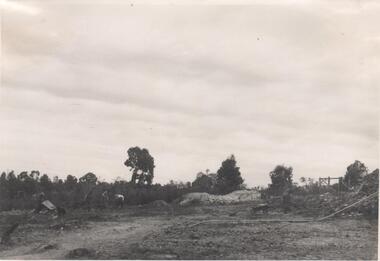
Photograph, Pasture with new road
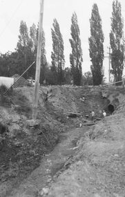
... Probably one of a series of photos (not identified in EDHS collection) showing purpurted excavation works, possibly road making. No date ...Back: "N.B. the left hand side of the excavation was once used in a similar manner but is once more under pasture." 17 ...Probably one of a series of photos (not identified in EDHS collection) showing purpurted excavation works, possibly road making. No date peter bassett smith kangaroo ground road making pasture farm Back: "N.B. the left hand side of the excavation was once used in a similar manner but is once more under pasture." 17 1 colour photograph Pasture with new road Photograph ...Probably the Bassett-Smith property at Menzies Road, Kangaroo Ground. Probably one of a series of photos (not identified in EDHS collection) showing purpurted excavation works, possibly road making. No date 1 colour photographBack: "N.B. the left hand side of the excavation was once used in a similar manner but is once more under pasture." 17 peter bassett smith, kangaroo ground, road making, pasture, farm -
 Sunbury Family History and Heritage Society Inc.
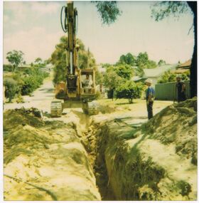
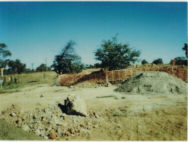
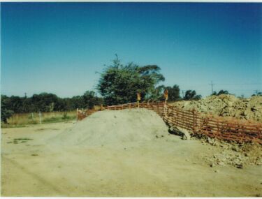
Photograph, 2000
... Excavation work began to remove the grasslands and trees on the railway land on the west side of the Sunbury Station to make way for commercial development on that side of the line....A non-digital coloured photograph of excavation work in operation on land which has cyclone fencing around its perimeter. ...Sunbury railway station A non-digital coloured photograph of excavation work in operation on land which has cyclone fencing around its perimeter. ...Excavation work began to remove the grasslands and trees on the railway land on the west side of the Sunbury Station to make way for commercial development on that side of the line.A non-digital coloured photograph of excavation work in operation on land which has cyclone fencing around its perimeter. There are buildings in the middle distance beyond the work site.sunbury railway station -
Tatura Irrigation & Wartime Camps Museum
Photograph, Goulburn Waranga Main Channel Construction, 1957
... Large black and white photograph - dry mounted to cream board. Channel excavation scene - with excavator bucket in operation, right foreground. ...Bucket / Looking towards off-take at Goulburn Weir / Completed Excavation in Background....Channel excavation scene - with excavator bucket in operation, right foreground. ...Photo taken by the photographer for Victoria State Rivers and Water Supply Commission of the Goulburn Waranga main channel in 1957.Large black and white photograph - dry mounted to cream board. Channel excavation scene - with excavator bucket in operation, right foreground. Two men, one arm raised, pointing, in left foregroundBelow photo: "Goulburn Waranga Main Channel Construction / Bucyrus 200 W. Excavator with 6 c. yd. Bucket / Looking towards off-take at Goulburn Weir / Completed Excavation in Background.goulburn, waranga, irrigation, photo, victoria state rivers and water supply commission -
Tatura Irrigation & Wartime Camps Museum
Photograph, Goulburn Waranga Main Channel Construction, 1957
... Large black and white photograph - dry mounted to cream board. Channel excavation scene with excavator in right foreground, bucket scooping earth in middle foreground, two small figures of men working mid-distance....Bucket / Looking towards off-take at Goulburn Weir / Completed Excavation in Background....Bucket / Looking towards off-take at Goulburn Weir / Completed Excavation in Background. Large black and white photograph - dry mounted to cream board. ...Photo taken by the photographer for Victoria State Rivers and Water Supply Commission of the Goulburn Waranga main channel in 1957.Large black and white photograph - dry mounted to cream board. Channel excavation scene with excavator in right foreground, bucket scooping earth in middle foreground, two small figures of men working mid-distance.Below photo: "Goulburn Waranga Main Channel Construction / Bucyrus 200 W. Excavator with 6 c. yd. Bucket / Looking towards off-take at Goulburn Weir / Completed Excavation in Background.goulburn, waranga, irrigation, photo, victoria state rivers and water supply commission -
Tatura Irrigation & Wartime Camps Museum
Photograph, Goulburn Waranga Main Channel Construction, 1957
... Large black and white photograph - dry mounted to cream board. Channel excavation scene with excavator, bucket upraised, in right foreground. ...Bucket / Looking towards off-take at Goulburn Weir / Completed Excavation in Background....Channel excavation scene with excavator, bucket upraised, in right foreground. ...Photo taken by the photographer for Victoria State Rivers and Water Supply Commission of the Goulburn Waranga main channel in 1957.Large black and white photograph - dry mounted to cream board. Channel excavation scene with excavator, bucket upraised, in right foreground. Two men looking at something, left foreground. Two small figures mid distance.Below photo: "Goulburn Waranga Main Channel Construction / Bucyrus 200 W. Excavator with 6 c. yd. Bucket / Looking towards off-take at Goulburn Weir / Completed Excavation in Background.goulburn, waranga, irrigation, photo, victoria state rivers and water supply commission -
Tatura Irrigation & Wartime Camps Museum
Photograph, Goulburn Waranga Main Channel Construction, 1957
... Large black and white photograph - dry mounted to cream board. Channel excavation scene - with excavator bucket in operation / Man operation machine right foreground / Several small indistinct figures mid distance working in channel bed....Bucket / Looking towards off-take at Goulburn Weir / Completed Excavation in Background....Bucket / Looking towards off-take at Goulburn Weir / Completed Excavation in Background. Large black and white photograph - dry mounted to cream board. ...Photo taken by the photographer for Victoria State Rivers and Water Supply Commission of the Goulburn Waranga main channel in 1957.Large black and white photograph - dry mounted to cream board. Channel excavation scene - with excavator bucket in operation / Man operation machine right foreground / Several small indistinct figures mid distance working in channel bed.Below photo: "Goulburn Waranga Main Channel Construction / Bucyrus 200 W. Excavator with 6 c. yd. Bucket / Looking towards off-take at Goulburn Weir / Completed Excavation in Background.goulburn, waranga, irrigation, photo, victoria state rivers and water supply commission -
Tatura Irrigation & Wartime Camps Museum
Photograph, Goulburn Waranga Main Channel Construction, 1957
... Large black and white photograph - dry mounted to cream board. Channel excavation scene - with excavator operating right mid distance, scoop bucket operating top of earth wall left mid distance, supervised by figure on top of earth wall....Bucket / Looking towards off-take at Goulburn Weir / Completed Excavation in Background."...Bucket / Looking towards off-take at Goulburn Weir / Completed Excavation in Background." Large black and white photograph - dry mounted to cream board. ...Photo taken by the photographer for Victoria State Rivers and Water Supply Commission of the Goulburn Waranga main channel in 1957.Large black and white photograph - dry mounted to cream board. Channel excavation scene - with excavator operating right mid distance, scoop bucket operating top of earth wall left mid distance, supervised by figure on top of earth wall.Below photo: "Goulburn Waranga Main Channel Construction / Bucyrus 200 W. Excavator with 6 c. yd. Bucket / Looking towards off-take at Goulburn Weir / Completed Excavation in Background."goulburn, waranga, irrigation, photo, victoria state rivers and water supply commission -
 St Kilda Historical Society
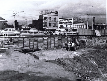
Photograph, Excavation work at St Kilda Junction during reconstruction of traffic lanes 28/3/1967, c.1967
... Excavation work at St Kilda Junction during reconstruction of traffic lanes 28/3/1967...hand written on back: Excavation work at St Kilda Junction during reconstruction of traffic lanes Photo filed 28.3.1967...Excavation work at St Kilda Junction during reconstruction of traffic lanes. ...St Kilda Historical Society St Kilda Branch Library 150 Carlisle Street St Kilda melbourne hand written on back: Excavation work at St Kilda Junction during reconstruction of traffic lanes Photo filed 28.3.1967 Excavation work at St Kilda Junction during reconstruction of traffic lanes. ...hand written on back: Excavation work at St Kilda Junction during reconstruction of traffic lanes Photo filed 28.3.1967black and white matt photograph good condition unmountedExcavation work at St Kilda Junction during reconstruction of traffic lanes. Photo filed 28.3.1967. H71. L3290. Copyright. This photograph may not be reproduced without permission in writing from the Editor of "The Age". 250 Spencer Street, Melbourne and 39/41 York st, Sydney. -
 Bendigo Historical Society Inc.
Photograph - Napoleon Reef Gold Mine Battery Site, 1936
... Written in pencil on back of photograph: ' Battery excavations started 22/9/36' and 'excavations started'....Napoleon Gold Mine Napoleon Reef Gold Mine Written in pencil on back of photograph: ' Battery excavations started 22/9/36' and 'excavations started'. ...The Napoleon (BML) gold mine (1932) was located beside McDougall Road, Golden Gully, between Martin and Hattam Street. It had a depth of 921 feet. It was one of the latest and most lavish of Bendigo's mines. Plant and equipment were electrically driven. The four-compartment shaft, extra large by goldfield's standards, measured 17 feet 6 inches by 5 feet 2 inches and was cement lined below 900 feet instead of being red gum boxed as was the usual practice. The workshop was equipped to carry out all repairs for the equally lavish BML mines on the Nell Gwynne and Carshalton reefs. (The Gold Mines of Bendigo, Book 2, Arthur Victor Palmer)Significant to mining history of Bendigo.Black and white photograph. Image shows flat, open landscape with four large eucalypt trees in centre of image. Four men working with shovels on left hand side of image, one man with wheelbarrow and dog alongside. Wooden framed structure on right hand side. Written in pencil on back of photograph: ' Battery excavations started 22/9/36' and 'excavations started'.napoleon gold mine, napoleon reef gold mine -
 Bendigo Historical Society Inc.
Photograph - CASTLEMAINE GAS COMPANY COLLECTION: PHOTO EXCAVATION
... Excavation at Unknown Location...ORGANISATION Industry gas and fuel Polaroid Excavation at Unknown Location Photograph CASTLEMAINE GAS COMPANY COLLECTION: PHOTO EXCAVATION ...Excavation at Unknown LocationPolaroidorganisation, industry, gas and fuel -
Glenelg Shire Council Cultural Collection
Slide - Slide - Construction Portland/Cashmore Airport, c. 1980
... Coloured slide. Deep excavation. Crane about to lift black fuel tank; Excavator, on far bank of excavation. ...Glenelg Shire Council Cultural Collection History House Cliff Street Portland great-ocean-road Coloured slide. Deep excavation. Crane about to lift black fuel tank; Excavator, on far bank of excavation. ...Coloured slide. Deep excavation. Crane about to lift black fuel tank; Excavator, on far bank of excavation. Workman with barrow in foreground. Wooden form for concrete work, angling down into excavation. -
 Bendigo Historical Society Inc.
Photograph - CASTLEMAINE GAS COMPANY COLLECTION: PHOTO EXCAVATION
... Excavation - Location and Date Unknown...History House 11 Mackenzie Street Bendigo goldfields ORGANISATION Industry gas and fuel Kodak Excavation - Location and Date Unknown Photograph CASTLEMAINE GAS COMPANY COLLECTION: PHOTO EXCAVATION ...Excavation - Location and Date UnknownKodakorganisation, industry, gas and fuel -
 Bendigo Historical Society Inc.
Photograph - CASTLEMAINE GAS COMPANY COLLECTION: PHOTO EXCAVATION
... Unknown Location and Date - Excavation...ORGANISATION Industry gas and fuel Polaroid Unknown Location and Date - Excavation Photograph CASTLEMAINE GAS COMPANY COLLECTION: PHOTO EXCAVATION ...Unknown Location and Date - ExcavationPolaroidorganisation, industry, gas and fuel