Showing 417 items matching " field family"
-
 Eltham District Historical Society Inc
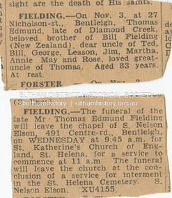
Folder, Fielding, 1955-1957
... Folder of information on Fielding family of Research...Yandell Mrs McLennan Robert Wingrove Rose Chapel St katherine's Church Folder of information on Fielding family of Research Fielding Folder ...Folder Contents 1. Newspaper clippings: Death and Funeral notices; Thomas Edmund Fielding, Publication unknown, Nov. 1957 2. Letter: L. C. Yandell to Thomas Fielding, 21 September 1955 requesting information pertaining to the history of St Katerine's Church, St Helena and Rose ChapelFolder of information on Fielding family of Researchdeath notice, funeral notice, thomas edmund fielding, tom fielding collection, jim beale, l.c. yandell, mrs mclennan, robert wingrove, rose chapel, st katherine's church -
 Bendigo Historical Society Inc.
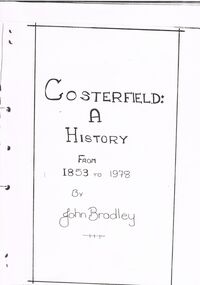
Document - COSTERFIELD: A HISTORY FROM 1853 TO 1978
... ... Field Family...Includes mining history of North Costerfield and South Costerfield Mines; information on Coster family and Field family; coach services to Costerfield; Post Office services; schools in Costerfield; churches at Costerfield; (Indian) hawkers; shops and hotels; boarding houses; blacksmiths; Police in Costerfield; Scheelite mine; Sport; Costerfield Band; Public halls; Cemetery; farmers of the area. ...History House 11 Mackenzie Street Bendigo goldfields GOLD Goldfields Costerfield Costerfield Mines Coster Family Field Family Post Office Cemetery Football Boarding houses Blacksmith Hotels and Shops. ...''COSTERFIELD: A HISTORY FROM 1853 TO 1978'' - PAPER BY JOHN BRADLEY A Paper for History Dip II (where?). 22 handwritten pages with additional pages of photographs. Includes mining history of North Costerfield and South Costerfield Mines; information on Coster family and Field family; coach services to Costerfield; Post Office services; schools in Costerfield; churches at Costerfield; (Indian) hawkers; shops and hotels; boarding houses; blacksmiths; Police in Costerfield; Scheelite mine; Sport; Costerfield Band; Public halls; Cemetery; farmers of the area. Page of acknowledgements; Bibliography; Reproduction (poor) of photographs of early photograph of Costerfield (1890); miners at 'Big Antimony Mine , 1912'; Bombay Mine; various buildings; football club membership 'tickets'; auction advertisement - mining plant, 1902; sale of mining equipment 1941; engine room at the Costerfield Mine 1939; race between motorbike and horse and jinker; school photo - various years 1910-1914; football teams; sketches of public hall and Brown's Mine Tavern (and Billiard Rooms).John Bradleygold, goldfields, costerfield, costerfield mines, coster family, field family, post office, cemetery, football, boarding houses, blacksmith, hotels and shops. brown's mine tavern, big antimony mine. -
 Stawell Historical Society Inc
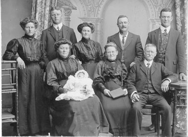
Photograph, Fielding Family Stawell 1911 -- Studio Portrait
... Portrait - Fielding Family Stawell 1911...Stawell Historical Society Inc 46 Longfield St Stawell grampians Portrait - Fielding Family Stawell 1911 Stawell Fielding Family Stawell 1911 -- Studio Portrait Photograph ...Portrait - Fielding Family Stawell 1911stawell -
 Greensborough Historical Society
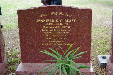
Photograph - Digital image, Marilyn Smith, Grave of Jennifer Kay Beasy, St Helena Cemetery, 25/12/1999
... The grave of Jennifer Kay Beasy (died 25/12/1999), (nee Oakley) a descendant of the Fielding family)...Greensborough Historical Society 34A Glenauburn Road Lower Plenty Lower Plenty melbourne The grave of Jennifer Kay Beasy (died 25/12/1999), (nee Oakley) a descendant of the Fielding family) St Helena Cemetery was originally the burial place of the Beale family and friends. ...The grave of Jennifer Kay Beasy (died 25/12/1999), (nee Oakley) a descendant of the Fielding family)St Helena Cemetery was originally the burial place of the Beale family and friends. The first burials took place in the 1850s. There are now over 200 burials.Digital copy of colour photographst helena cemetery, jennifer kay beasy -
 Eltham District Historical Society Inc
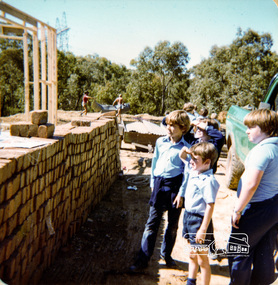
Photograph, Excursion to Fields house next to school early in year, Eltham Christian School, 1982, 1982
... Excursion to Fields family house under construction next to school early in year, Eltham Christian School, 1982. ...Eltham District Historical Society Inc 728 Main Rd Eltham melbourne Excursion to Fields family house under construction next to school early in year, Eltham Christian School, 1982. ...Excursion to Fields family house under construction next to school early in year, Eltham Christian School, 1982. From a series of photographs (some cropped) from a magnetic photo album relating to the staff, students and activities of the Eltham Christian School which operated as part of the Eltham Christian Church at Nyora Road, Eltham. See also entries for each photograph.3 colour photographseltham christian school, nyora road, buildings, construction, field house -
 Stawell Historical Society Inc
Photograph, Mick Walsh, Mick Walsh Stawell Studio Colour Negatives, 1975 to 1986
... Shane Martin & Franklin Family Spencer & Martin 1948 Melbourne Cup Great Western Races 1982 Pakistan Versus Country XI Cricket 6/1/82 Leanne Ross & Daryl Smith Marlene Jones & Stan Kluzek Leanne Seary & Ian Adams Mr & Mrs Alf Paulett family Committee Girls Jim & Eileen Barton 2/11/81 Jamie Pickering & Warren Hope Christine Ryan & Ron Boshuizen Wendy Slorach & Stephen Barrow Fielding Family Geoff & Julie Conboy Mc Leod Dellar Wedding Yvonne Currie ...Shane Martin & Franklin Family Spencer & Martin 1948 Melbourne Cup Great Western Races 1982 Pakistan Versus Country XI Cricket 6/1/82 Leanne Ross & Daryl Smith Marlene Jones & Stan Kluzek Leanne Seary & Ian Adams Mr & Mrs Alf Paulett family Committee Girls Jim & Eileen Barton 2/11/81 Jamie Pickering & Warren Hope Christine Ryan & Ron Boshuizen Wendy Slorach & Stephen Barrow Fielding Family Geoff & Julie Conboy Mc Leod Dellar Wedding Yvonne Currie Photography Mick Walsh 52 Patrick Street Stawell Colour negatives of families, weddings and other. ...Negatives from Stawell Photographer. Discarded from Penna Print Ararat. Son contacted and gave approval for Stawell Historical Society to keep them. Only those of a non personal nature scanned. Shane Martin & Franklin Family Spencer & Martin 1948 Melbourne Cup Great Western Races 1982 Pakistan Versus Country XI Cricket 6/1/82 Leanne Ross & Daryl Smith Marlene Jones & Stan Kluzek Leanne Seary & Ian Adams Mr & Mrs Alf Paulett family Committee Girls Jim & Eileen Barton 2/11/81 Jamie Pickering & Warren Hope Christine Ryan & Ron Boshuizen Wendy Slorach & Stephen Barrow Fielding Family Geoff & Julie Conboy Mc Leod Dellar Wedding Yvonne Currie Colour negatives of families, weddings and other. Nineteen Lever Arch Folders Mick Walsh 52 Patrick Street Stawellphotography -
 Eltham District Historical Society Inc
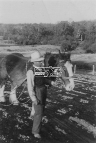
Photograph, Guildo Fabbro, Falkiner Street, Eltham with Clydesdale horse
... The area in Bell Street opposite the Eltham High School was purchased by the State Government is recent years and is called Fabbro Fields. The Fabbro Family operated their farm in Bell Street, Eltham. ...The area in Bell Street opposite the Eltham High School was purchased by the State Government is recent years and is called Fabbro Fields. The Fabbro Family operated their farm in Bell Street, Eltham. fabbro's farm guido fabbro bell street clydesdale horse 1 black and white photograph Guildo Fabbro, Falkiner Street, Eltham with Clydesdale horse Photograph Photograph ...Guildo Fabbro, Falkiner Street, Eltham with Clydesdale horse with harness in field. The site of the Fabbro farm (Diamond Creek side land) is now called Barrack Bushlands. It is doubtful that Fabbro's farm holding was ever called Barrak Park, This title is fairly recent after the Shire of Eltham purchased the land, including the last section in 1993/94. About this time the area on the west side of Falkiner Street was purchased by a private developer and developed as housing. The area in Bell Street opposite the Eltham High School was purchased by the State Government is recent years and is called Fabbro Fields. The Fabbro Family operated their farm in Bell Street, Eltham. 1 black and white photographfabbro's farm, guido fabbro, bell street, clydesdale horse -
 Eltham District Historical Society Inc
Photograph, Maurie Fabbro at age 20 at Fabbro's farm in Bell Street, Eltham, 1940, 1940
... The area in Bell Street opposite the Eltham High School was purchased by the State Government is recent years and is called Fabbro Fields. The Fabbro Family operated their farm in Bell Street, Eltham. ...The area in Bell Street opposite the Eltham High School was purchased by the State Government is recent years and is called Fabbro Fields. The Fabbro Family operated their farm in Bell Street, Eltham. ...The site of the Fabbro farm (Diamond Creek side land) is now called Barrack Bushlands. It is doubtful that Fabbro's farm holding was ever called Barrak Park, This title is fairly recent after the Shire of Eltham purchased the land, including the last section in 1993/94. About this time the area on the west side of Falkiner Street was purchased by a private developer and developed as housing. The area in Bell Street opposite the Eltham High School was purchased by the State Government is recent years and is called Fabbro Fields. The Fabbro Family operated their farm in Bell Street, Eltham. Maurice Joseph Fabbro (Mario) was born 19 January 1920 and passed away 19 November 20091 black and white photographfabbro's farm, maurice fabbro -
 Eltham District Historical Society Inc
Photograph, From left: Unknown, Mario Fabbro and possibly Helen Skipper, Bell Street, Eltham
... The area in Bell Street opposite the Eltham High School was purchased by the State Government is recent years and is called Fabbro Fields. The Fabbro Family operated their farm in Bell Street, Eltham. ...The area in Bell Street opposite the Eltham High School was purchased by the State Government is recent years and is called Fabbro Fields. The Fabbro Family operated their farm in Bell Street, Eltham. fabbro's farm bell street eltham maurice fabbro farming helen skipper vegetables 1 black and white photograph From left: Unknown, Mario Fabbro and possibly Helen Skipper, Bell Street, Eltham Photograph Photograph ...At Bell Street, Fabbro Farm, Eltham; From left: Unknown, Mario Fabbro and possibly Helen Skipper, standing in the middle of a vegetable crop. The site of the Fabbro farm (Diamond Creek side land) is now called Barrack Bushlands. It is doubtful that Fabbro's farm holding was ever called Barrak Park, This title is fairly recent after the Shire of Eltham purchased the land, including the last section in 1993/94. About this time the area on the west side of Falkiner Street was purchased by a private developer and developed as housing. The area in Bell Street opposite the Eltham High School was purchased by the State Government is recent years and is called Fabbro Fields. The Fabbro Family operated their farm in Bell Street, Eltham. 1 black and white photographfabbro's farm, bell street, eltham, maurice fabbro, farming, helen skipper, vegetables -
 Eltham District Historical Society Inc
Photograph, Fabbro's farm, Bell Street, Eltham, c.1990s
... The area in Bell Street opposite the Eltham High School was purchased by the State Government is recent years and is called Fabbro Fields. The Fabbro Family operated their farm in Bell Street, Eltham. ...The area in Bell Street opposite the Eltham High School was purchased by the State Government is recent years and is called Fabbro Fields. The Fabbro Family operated their farm in Bell Street, Eltham. fabbro's farm bell street eltham artichokes barak farm 1 colour photograph printed with white border Fabbro's farm, Bell Street, Eltham, c.1990s Photograph Photograph ...Fabbro's farm and house, Bell Street, Eltham, c.1990s. A crop of artichokes were planted on the farm at this time. The site of the Fabbro farm (Diamond Creek side land) is now called Barrack Bushlands. It is doubtful that Fabbro's farm holding was ever called Barrak Park, This title is fairly recent after the Shire of Eltham purchased the land, including the last section in 1993/94. About this time the area on the west side of Falkiner Street was purchased by a private developer and developed as housing. The area in Bell Street opposite the Eltham High School was purchased by the State Government is recent years and is called Fabbro Fields. The Fabbro Family operated their farm in Bell Street, Eltham. 1 colour photograph printed with white borderfabbro's farm, bell street, eltham, artichokes, barak farm -
 Eltham District Historical Society Inc
Photograph, Artichokes growing at Bell Street, Eltham, c.1990s
... The area in Bell Street opposite the Eltham High School was purchased by the State Government is recent years and is called Fabbro Fields. The Fabbro Family operated their farm in Bell Street, Eltham. ...The area in Bell Street opposite the Eltham High School was purchased by the State Government is recent years and is called Fabbro Fields. The Fabbro Family operated their farm in Bell Street, Eltham. fabbro's farm bell street eltham artichokes barak farm 1 colour photograph printed with white border Artichokes growing at Bell Street, Eltham, c.1990s. ...Fabbro's farm and house, Bell Street, Eltham, c.1990s. A crop of artichokes were planted on the farm at this time. The site of the Fabbro farm (Diamond Creek side land) is now called Barrack Bushlands. It is doubtful that Fabbro's farm holding was ever called Barrak Park, This title is fairly recent after the Shire of Eltham purchased the land, including the last section in 1993/94. About this time the area on the west side of Falkiner Street was purchased by a private developer and developed as housing. The area in Bell Street opposite the Eltham High School was purchased by the State Government is recent years and is called Fabbro Fields. The Fabbro Family operated their farm in Bell Street, Eltham. 1 colour photograph printed with white borderfabbro's farm, bell street, eltham, artichokes, barak farm -
 Eltham District Historical Society Inc
Photograph, Maurice Fabbro with artichokes growing at Bell Street, Eltham, c.1990s. Maurie is in his 70s
... The area in Bell Street opposite the Eltham High School was purchased by the State Government is recent years and is called Fabbro Fields. The Fabbro Family operated their farm in Bell Street, Eltham. ...The area in Bell Street opposite the Eltham High School was purchased by the State Government is recent years and is called Fabbro Fields. The Fabbro Family operated their farm in Bell Street, Eltham. fabbro's farm bell street eltham artichokes barak farm maurice fabbro 1 colour photograph printed with white border Maurice Fabbro with artichokes growing at Bell Street, Eltham, c.1990s. ...Fabbro's farm and house, Bell Street, Eltham, c.1990s. A crop of artichokes were planted on the farm at this time. The site of the Fabbro farm (Diamond Creek side land) is now called Barrack Bushlands. It is doubtful that Fabbro's farm holding was ever called Barrak Park, This title is fairly recent after the Shire of Eltham purchased the land, including the last section in 1993/94. About this time the area on the west side of Falkiner Street was purchased by a private developer and developed as housing. The area in Bell Street opposite the Eltham High School was purchased by the State Government is recent years and is called Fabbro Fields. The Fabbro Family operated their farm in Bell Street, Eltham. 1 colour photograph printed with white borderfabbro's farm, bell street, eltham, artichokes, barak farm, maurice fabbro -
 Eltham District Historical Society Inc
Photograph, Antonio and Angelina Casonato and family
... The area in Bell Street opposite the Eltham High School was purchased by the State Government is recent years and is called Fabbro Fields. The Fabbro Family operated their farm in Bell Street, Eltham. ...The area in Bell Street opposite the Eltham High School was purchased by the State Government is recent years and is called Fabbro Fields. The Fabbro Family operated their farm in Bell Street, Eltham. fabbro's farm bell street eltham farming vegetables Angelina Casonato Antonio Casonato Fabbro family Fabbro farm Fabbro fields 1 black and white photograph reproduction print (low quality) Antonio and Angelina Casonato and family Photograph Photograph ...Antonio and Angelina Casonato with their four children and a baby cousin taken with lettuces growing on the river flat at Bell Street, Fabbro Farm (Fabbro Fields) in front of Eltham High School in the late 1960s. The site of the Fabbro farm (Diamond Creek side land) is now made up of Fabbro Fileds and Barrack Bushlands. This title is fairly recent after the Shire of Eltham purchased the land, including the last section in 1993/94. About this time the area on the west side of Falkiner Street was purchased by a private developer and developed as housing. The area in Bell Street opposite the Eltham High School was purchased by the State Government is recent years and is called Fabbro Fields. The Fabbro Family operated their farm in Bell Street, Eltham. 1 black and white photograph reproduction print (low quality)fabbro's farm, bell street, eltham, farming, vegetables, angelina casonato, antonio casonato, fabbro family, fabbro farm, fabbro fields -
 Eltham District Historical Society Inc
Photograph, At Bell Street, Eltham; from left: Helen Skipper, Matcham Skipper, Sonia Skipper and possibly Myra Skipper
... The area in Bell Street opposite the Eltham High School was purchased by the State Government is recent years and is called Fabbro Fields. The Fabbro Family operated their farm in Bell Street, Eltham. ...The area in Bell Street opposite the Eltham High School was purchased by the State Government is recent years and is called Fabbro Fields. The Fabbro Family operated their farm in Bell Street, Eltham. fabbro's farm bell street eltham farming helen skipper vegetables matchcam skipper myra skipper sonia skipper 1 black and white photograph At Bell Street, Eltham; from left: Helen Skipper, Matcham Skipper, Sonia Skipper and possibly Myra Skipper Photograph Photograph ...At Bell Street, Fabbro Farm, Eltham; From left: Helen Skipper, Matcham Skipper, Sonia Skipper and possibly Myra Skipper, standing in the middle of a vegetable crop. The site of the Fabbro farm (Diamond Creek side land) is now called Barrack Bushlands. It is doubtful that Fabbro's farm holding was ever called Barrak Park, This title is fairly recent after the Shire of Eltham purchased the land, including the last section in 1993/94. About this time the area on the west side of Falkiner Street was purchased by a private developer and developed as housing. The area in Bell Street opposite the Eltham High School was purchased by the State Government is recent years and is called Fabbro Fields. The Fabbro Family operated their farm in Bell Street, Eltham. 1 black and white photographfabbro's farm, bell street, eltham, farming, helen skipper, vegetables, matchcam skipper, myra skipper, sonia skipper -
 Eltham District Historical Society Inc
Photograph, At Bell Street; from left: Maurie Fabbro, Myra Skipper, Unknown, Arthur Munday, Ian Robertson. Helen Comprione in front
... The area in Bell Street opposite the Eltham High School was purchased by the State Government is recent years and is called Fabbro Fields. The Fabbro Family operated their farm in Bell Street, Eltham. ...The area in Bell Street opposite the Eltham High School was purchased by the State Government is recent years and is called Fabbro Fields. The Fabbro Family operated their farm in Bell Street, Eltham. fabbro's farm guido fabbro bell street arhur munday eltham helen comprione ian robertson maurice fabbro myra skipper picking farming 1 black and white photograph At Bell Street; from left: Maurie Fabbro, Myra Skipper, Unknown, Arthur Munday, Ian Robertson. ...At Bell Street, Fabbro Farm, Eltham; from left: Maurie Fabbro, Myra Skipper, Unknown, Arthur Munday, Ian Robertson. Helen Comprione in front - probably helping to pick a crop. The site of the Fabbro farm (Diamond Creek side land) is now called Barrack Bushlands. It is doubtful that Fabbro's farm holding was ever called Barrak Park, This title is fairly recent after the Shire of Eltham purchased the land, including the last section in 1993/94. About this time the area on the west side of Falkiner Street was purchased by a private developer and developed as housing. The area in Bell Street opposite the Eltham High School was purchased by the State Government is recent years and is called Fabbro Fields. The Fabbro Family operated their farm in Bell Street, Eltham. 1 black and white photographfabbro's farm, guido fabbro, bell street, arhur munday, eltham, helen comprione, ian robertson, maurice fabbro, myra skipper, picking, farming -
 Eltham District Historical Society Inc
Photograph, Maurice Fabbro and his mother Regina (wife of Guido) taken at home in Falkiner Street, Eltham
... The area in Bell Street opposite the Eltham High School was purchased by the State Government is recent years and is called Fabbro Fields. The Fabbro Family operated their farm in Bell Street, Eltham. ...The area in Bell Street opposite the Eltham High School was purchased by the State Government is recent years and is called Fabbro Fields. The Fabbro Family operated their farm in Bell Street, Eltham. ...Maurice Fabbro and his mother Regina (wife of Guido) taken at home in Falkiner Street, Eltham. Regina passed away 21/03/1986 age 92 and is buried at Eltham Cemetery. (source: http://www.elthamcemetery.com/index.php/deceased-search) The site of the Fabbro farm (Diamond Creek side land) is now called Barrack Bushlands. It is doubtful that Fabbro's farm holding was ever called Barrak Park, This title is fairly recent after the Shire of Eltham purchased the land, including the last section in 1993/94. About this time the area on the west side of Falkiner Street was purchased by a private developer and developed as housing. The area in Bell Street opposite the Eltham High School was purchased by the State Government is recent years and is called Fabbro Fields. The Fabbro Family operated their farm in Bell Street, Eltham. Eltham, Falkiner Street, Maurice Fabbro, Regina Fabbro1 colour photographfabbro's farm, bell street, eltham, maurice fabbro, regina fabbro -
 Melbourne Legacy
Badge - Legacy badge wallet, Legacy badges
... A small wallet of badges donated back to Melbourne Legacy by the family of Field Marshall Sir Thomas A Blamey (who was once a Patron of Legacy) and his son Lt. ...Melbourne Legacy 293 Swanston Street Melbourne melbourne A small wallet of badges donated back to Melbourne Legacy by the family of Field Marshall Sir Thomas A Blamey (who was once a Patron of Legacy) and his son Lt. ...A small wallet of badges donated back to Melbourne Legacy by the family of Field Marshall Sir Thomas A Blamey (who was once a Patron of Legacy) and his son Lt. Col. Thomas R Blamey who was an active supporter of Legacy throughout his life, especially on the Mornington Peninsula. The folder contains 21 badges of various colours and donation values. One green enamel on metal badge marked 10 pounds or 20 dollars - oldest one as pre-decimal. With a clip on back. One green enamel on metal badge marked $20. With a clip on back Four orange enamel elongated shape stick pin marked $25 Four blue enamel shield shape stick pin marked $10 Two yellow enamel pentagon stick pin marked $5 One yellow plastic pentagon badge on short pin $5 Three blue plastic torch badges on short pin $1 Three red plastic torch badges on short pin $2 One pink plastic torch badge marked $2 One pink plastic rectangle badge marked $2 One gold with red enamel Widows broch missing its pin. Various manufacturing dates but all produced by AJ Parkes.Shows that the Blamey family supported Legacy with badge day.Dark brown thick cardboard folder with sponge inside to hold badges. 21 Legacy badges and one Legacy Widows broch.badges, blamey -
 Warrnambool and District Historical Society Inc.
Wedding Dress, 1942
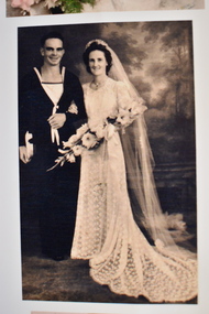
... The photograph shows the wedding of Field James (Jim) Heazlewood and Mavis Marie McDonald who were married on 23/12/1942 This dress is of of some significance as it is not only a lovely example of a 1940s wedding dress but it has local provenance, being worn by a Warrnambool person, Ena Todd when she married another Warrnambool identity, Jack Heazlewood in 1942. vintage clothing todd & heazlewood families, warrnambool This is a white lace dress with a fitted bodice, a square neckline and a lace band at the waist edged with satin. ...This wedding dress came from the estate of Ena Heazlewood. Born in Warrnambool in 1920 Mary Josephine (Ena) Todd was a hairdresser at Josephine’s Salon in Warrnambool. In 1942 she married a Warrnambool man, Jack Heazlewood, a stoker on the H.M.A.S. Sydney at the time. She was wearing this wedding dress. The dress was also worn by two other brides – Ena’s sister-in-law. Mavis McDonald when she married Jim Heazlewood in December 1942 and her sister Rita Todd when she married Bill Kane in 1947 (the bodice of the dress was altered for Rita’s wedding). The photograph shows the wedding of Field James (Jim) Heazlewood and Mavis Marie McDonald who were married on 23/12/1942This dress is of of some significance as it is not only a lovely example of a 1940s wedding dress but it has local provenance, being worn by a Warrnambool person, Ena Todd when she married another Warrnambool identity, Jack Heazlewood in 1942. This is a white lace dress with a fitted bodice, a square neckline and a lace band at the waist edged with satin. The dress has set-in long sleeves with a press stud clips at the wrists. The waist at the back has a loose band of lace material. The skirt is slightly flared and is floor length at the front with a cotton net frill edging, now slightly tattered. The dress at the back has a wide rounded train with a net frill edging. The side ends of the train have inserted lace panels. The dress is slightly yellowed with age. vintage clothing, todd & heazlewood families, warrnambool -
 Warrnambool and District Historical Society Inc.
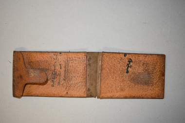
Artefact, Field Wallet, Early 20th century
... field wallet that belonged to Rolf Crawley. He was an engineer, surveyor and architect in private practice in Warrnambool and also the engineer for the Shire of Warrnambool from 1935 to 1968. His grandfather, father and uncle were also engineers, working in that capacity or as the Shire Secretary for the Shire of Warrnambool, with the Crawley family recording a total of 132 years service to the Shire. ...field wallet that belonged to Rolf Crawley. He was an engineer, surveyor and architect in private practice in Warrnambool and also the engineer for the Shire of Warrnambool from 1935 to 1968. His grandfather, father and uncle were also engineers, working in that capacity or as the Shire Secretary for the Shire of Warrnambool, with the Crawley family recording a total of 132 years service to the Shire. ...This is a field wallet that belonged to Rolf Crawley. He was an engineer, surveyor and architect in private practice in Warrnambool and also the engineer for the Shire of Warrnambool from 1935 to 1968. His grandfather, father and uncle were also engineers, working in that capacity or as the Shire Secretary for the Shire of Warrnambool, with the Crawley family recording a total of 132 years service to the Shire. The Shire of Warrnambool existed from 1863 to 1994. The wallet came into the possession of Michael Hand who took over the private surveying business of Rolf Crawley in Warrnambool. The Warrnambool and District Historical Society acquired the wallet, along with several ledgers and other Crawley memorabilia from the estate of Michael Hand. This wallet is of interest as it was owned and used by Rolf Crawley when he was doing field work in connection with his surveying and engineering jobs either in private practice or as the Shire of Warrnambool engineer in the 20th century. This is a brown leather wallet in two sections that fold over and close with a flap or tongue that inserts into a strip of leather stitched into the cover. The two sections have extra pieces of leather that are stitched on to make compartments. These contain three pieces of thick card folded over. These cards have rough notes and figures handwritten on them. Inside the wallet is a hand-printed name. The wallet is much scuffed and stained. ‘Rolf L. Crawley L. S. Shire Hall Warrnambool’rolf crawley, warrnambool, shire of warrnambool -
 Warrnambool and District Historical Society Inc.
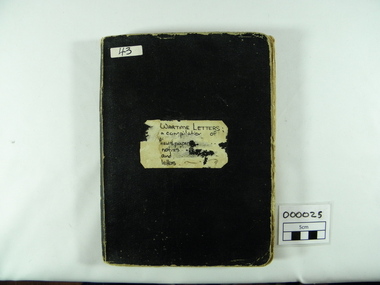
Archive - Scrapbook, Wartime Letters a compilation of newspapers, notices and letters, 1914-1930's
... family and pasted into the exercise book, possibly by Jessie Bonnett. The book has been transcribed and republished by the Warrnambool and District Historical Society under the title Fields Of War. ...family and pasted into the exercise book, possibly by Jessie Bonnett. The book has been transcribed and republished by the Warrnambool and District Historical Society under the title Fields Of War. ...These letters etc were initially printed in the Warrnambool Standard and other newspapers during the First World War. They were collected by the Bonnett family and pasted into the exercise book, possibly by Jessie Bonnett. The book has been transcribed and republished by the Warrnambool and District Historical Society under the title Fields Of War. It contains the names of over six hundred soldiers from the Warrnambool District.This represents a valuable insight into the lives, experiences and feelings of WWI soldiers and nurses and their families. It has value in the individual letters collected with many of the originals no longer surviving but also as a collection. It has strong social and historical significance.Black cloth covered, rectangular, thick exercise book with lined page with glue and string binding. A recycled book with original mathematics notation overlaid by newspaper clippings pasted in three columns per page. Includes photographs, letters, poems, related cuttings and notices. WARTIME LETTERS a compilation of newspapers/notices/and/letterswartime letters, newspapers, jessie bonnett, letters, photographs, poetry, first world war, warrnambool standard -
 Bendigo Military Museum
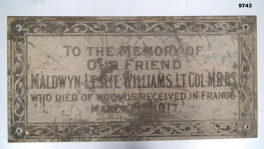
Plaque - MEMORIAL PLAQUE, WW1, C G Roeszler & Son, Post WW1
... Field Ambulance Unit. Wounded near Bapaume 2nd March 1917; died from wounds 3rd March 1917. Buried at Dernancourt Cemetery, France. The engraver of the plaque was C.G. Roeszler & Son of Melbourne. This business was founded in 1869 and is still family...Field Ambulance Unit. Wounded near Bapaume 2nd March 1917; died from wounds 3rd March 1917. Buried at Dernancourt Cemetery, France. The engraver of the plaque was C.G. Roeszler & Son of Melbourne. This business was founded in 1869 and is still family ...Born in Castlemaine 1886. Maldwyn L. Williams (Leslie) was a prominent doctor in Bendigo, both at Bendigo Base Hospital and in private practice. He played several games in the Victorian Football League (VFL) whilst at university. Enlisted in Citizens Military Force in 1909 as Captain in Royal Australian Army Medical Corps. Promoted to Major in 1913. Sept 1915 - appointed Major in regular army, 8th Field Ambulance Unit. Nov 1915 - sailed for Egypt; June 1916 - sailed for Marseilles. Jan 1917 - promoted to Lt. Colonel and command of 1st Field Ambulance Unit. Wounded near Bapaume 2nd March 1917; died from wounds 3rd March 1917. Buried at Dernancourt Cemetery, France. The engraver of the plaque was C.G. Roeszler & Son of Melbourne. This business was founded in 1869 and is still family-owned and trading today. This company is responsible for many examples of engraving around Melbourne, including work on the 1928 Ringwood Memorial Clock and in St Paul's Cathedral in Flinders St, Melbourne. Rectangular metal plaque, possibly brass. 4cm border featuring botanical motif. A flower with eight round petals at each corner - each flower has a 0.7cm hole at its centre. Decoration and inscription engraved and filled with black material, possibly shellac or enamel paint which is degraded, cracking, and loose.Main inscription: "TO THE MEMORY OF/OUR FRIEND/MALDWYN LESLIE WILLIAMS. LT. COL, M.B,B.S./WHO DIED OF WOUNDS RECEIVED IN FRANCE/MARCH 3RD ['RD" is in smaller font and higher that other letters with a dot beneath] 1917.' Bottom right: "C.G. ROESZLER & SON MELB".plaque, memorial -
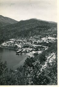 Kiewa Valley Historical Society
Photo - Bogong Township, March 1944
... In 1940 Field Headquarters for the Kiewa Scheme were established at Bogong with office, workshop facilities and accommodation for workmen, staff and some families constructed. ...Kiewa Valley Historical Society Mount Beauty Information Centre 31 Bogong High Plains Rd Mt Beauty high-country In 1940 Field Headquarters for the Kiewa Scheme were established at Bogong with office, workshop facilities and accommodation for workmen, staff and some families constructed. ...In 1940 Field Headquarters for the Kiewa Scheme were established at Bogong with office, workshop facilities and accommodation for workmen, staff and some families constructed. (There had been a 'tent camp' on this site in 1939 but was destroyed by bushfires) Construction of accommodation continued until 1947. A total of 40 houses plus a hostel for single staff, post office, police station, medical centre and primary school all with water and sewerage and electricity supply. The staff hostel was known as Kiewa House and is now occupied by the Education Department. Lake Guy was named after Mr. L.T. Guy who was the Resident Engineer in charge of construction work and associated activities on the Kiewa area. He held this position from 1939 to November 1946 when he was transferred to Head Office. The Bogong Township was developed firstly as an accommodation centre (base camp) for construction workers employed under the Kiewa Hydroelectric Scheme. Due to the influx of European workers into the Township the beautification of the immediate surrounds (gardens etc.) had a distinct European flavour. This environment has been very beneficial for tourism in later years. At the completion of the scheme, in the 1960's, the village was opened to public/tourism use. Strict environmental control has not allowed for any extensive redevelopment in tourist accommodation and basically restricted it to the accommodation initially built for the construction workers. Activities such a bike riding, snow skiing, restricted horse riding and bush walking on the Alpine plains and mountains are now a viable part of the Kiewa Valley Tourist Industry. The lake is one of the many water storage reservoirs used to supply the power stations their main power to run the huge turbines generating the final product, electricityBlack and white photograph of Bogong Township taken March 1944Handwritten on the back of photo - Township March '44bogong village, secv -
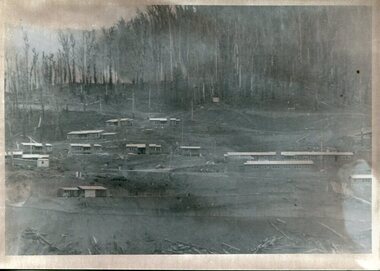 Kiewa Valley Historical Society
Photograph - Bogong Village (7 copies), Approx 1940
... In 1940 Field Headquarters for the Kiewa Scheme were established at Bogong with office, workshop facilities and accommodation for workmen, staff and some families constructed. ...Kiewa Valley Historical Society Mount Beauty Information Centre 31 Bogong High Plains Rd Mt Beauty high-country In 1940 Field Headquarters for the Kiewa Scheme were established at Bogong with office, workshop facilities and accommodation for workmen, staff and some families constructed. ...In 1940 Field Headquarters for the Kiewa Scheme were established at Bogong with office, workshop facilities and accommodation for workmen, staff and some families constructed. (There had been a 'tent camp' on this site in 1939 but was destroyed by bushfires) Construction of accommodation continued until 1947. A total of 40 houses plus a hostel for single staff, post office, police station, medical centre and primary school all with water and sewerage and electricity supply. The staff hostel was known as Kiewa House and is now occupied by the Education Department. Lake Guy was named after Mr. L.T. Guy who was the Resident Engineer in charge of construction work and associated activities on the Kiewa area. He held this position from 1939 to November 1946 when he was transferred to Head Office. The Bogong Township was developed firstly as an accommodation centre (base camp) for construction workers employed under the Kiewa Hydroelectric Scheme. Due to the influx of European workers into the Township the beautification of the immediate surrounds (gardens etc.) had a distinct European flavour. This environment has been very beneficial for tourism in later years. At the completion of the scheme, in the 1960's, the village was opened to public/tourism use. Strict environmental control has not allowed for any extensive redevelopment in tourist accommodation and basically restricted it to the accommodation initially built for the construction workers. Activities such a bike riding, snow skiing, restricted horse riding and bush walking on the Alpine plains and mountains are now a viable part of the Kiewa Valley Tourist Industry. The lake is one of the many water storage reservoirs used to supply the power stations their main power to run the huge turbines generating the final product, electricity. Evidence can be seen of the 1939 bushfires.Set of 7 identical black and white photographs of Bogong Village after 1939 bush firesHandwritten on the back of one photo - Bogong Village approx. 1940, after 1939 bush fires. Staff residences to left. Kiewa House, General offices and test lab to the right. Hand drawn map on the back of one photo.bogong village, secv -
 Kiewa Valley Historical Society
Photo - Bogong Village Township, October 8, 1946
... In 1940 Field Headquarters for the Kiewa Scheme were established at Bogong with office, workshop facilities and accommodation for workmen, staff and some families constructed. ...Kiewa Valley Historical Society Mount Beauty Information Centre 31 Bogong High Plains Rd Mt Beauty high-country In 1940 Field Headquarters for the Kiewa Scheme were established at Bogong with office, workshop facilities and accommodation for workmen, staff and some families constructed. ...In 1940 Field Headquarters for the Kiewa Scheme were established at Bogong with office, workshop facilities and accommodation for workmen, staff and some families constructed. (There had been a 'tent camp' on this site in 1939 but was destroyed by bushfires) Construction of accommodation continued until 1947. A total of 40 houses plus a hostel for single staff, post office, police station, medical centre and primary school all with water and sewerage and electricity supply. The staff hostel was known as Kiewa House and is now occupied by the Education Department. Lake Guy was named after Mr. L.T. Guy who was the Resident Engineer in charge of construction work and associated activities on the Kiewa area. He held this position from 1939 to November 1946 when he was transferred to Head Office. The Bogong Township was developed firstly as an accommodation centre (base camp) for construction workers employed under the Kiewa Hydroelectric Scheme. Due to the influx of European workers into the Township the beautification of the immediate surrounds (gardens etc.) had a distinct European flavour. This environment has been very beneficial for tourism in later years. At the completion of the scheme, in the 1960's, the village was opened to public/tourism use. Strict environmental control has not allowed for any extensive redevelopment in tourist accommodation and basically restricted it to the accommodation initially built for the construction workers. Activities such a bike riding, snow skiing, restricted horse riding and bush walking on the Alpine plains and mountains are now a viable part of the Kiewa Valley Tourist Industry. The lake is one of the many water storage reservoirs used to supply the power stations their main power to run the huge turbines generating the final product, electricityBlack and white photograph of Bogong Village which appeared in the Herald Sun newspaper on October 8, 1946. Page 13Handwritten on the back - Town of Bogong on a rugged mountain slope above Lake Guy. State Electricity Committee workers on the Kiewa Hydro Electric scheme live here in all electric homes. Stamped on the back - Copyright Not for reproduction Herald Sun Feature Service Melbourne Australiabogong village; lake guy; kiewa hydro electric scheme -
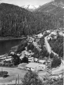
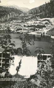 Kiewa Valley Historical Society
Postcard - Lake Guy and Bogong Village
... In 1940 Field Headquarters for the Kiewa Scheme were established at Bogong with office, workshop facilities and accommodation for workmen, staff and some families constructed. ...Kiewa Valley Historical Society Mount Beauty Information Centre 31 Bogong High Plains Rd Mt Beauty high-country In 1940 Field Headquarters for the Kiewa Scheme were established at Bogong with office, workshop facilities and accommodation for workmen, staff and some families constructed. ...In 1940 Field Headquarters for the Kiewa Scheme were established at Bogong with office, workshop facilities and accommodation for workmen, staff and some families constructed. (There had been a 'tent camp' on this site in 1939 but was destroyed by bushfires) Construction of accommodation continued until 1947. A total of 40 houses plus a hostel for single staff, post office, police station, medical centre and primary school all with water and sewerage and electricity supply. The staff hostel was known as Kiewa House and is now occupied by the Education Department. Lake Guy was named after Mr. L.T. Guy who was the Resident Engineer in charge of construction work and associated activities on the Kiewa area. He held this position from 1939 to November 1946 when he was transferred to Head Office. The Bogong Township was developed firstly as an accommodation centre (base camp) for construction workers employed under the Kiewa Hydroelectric Scheme. Due to the influx of European workers into the Township the beautification of the immediate surrounds (gardens etc.) had a distinct European flavour. This environment has been very beneficial for tourism in later years. At the completion of the scheme, in the 1960's, the village was opened to public/tourism use. Strict environmental control has not allowed for any extensive redevelopment in tourist accommodation and basically restricted it to the accommodation initially built for the construction workers. Activities such a bike riding, snow skiing, restricted horse riding and bush walking on the Alpine plains and mountains are now a viable part of the Kiewa Valley Tourist Industry. The lake is one of the many water storage reservoirs used to supply the power stations their main power to run the huge turbines generating the final product, electricityBlack and white photographic postcard of Lake Guy and Bogong Village. Kiewa Hydro electric Project (showing Junction Dam in front)Handwritten on the back of postcard ' Like most of our camps, this looks like something from the Canadian Rockies' Stamped on the back - Valentine's Post Card A genuine photographlake guy, bogong village, secv -
 Kiewa Valley Historical Society
Photo - Bogong Township, September 1953
... In 1940 Field Headquarters for the Kiewa Scheme were established at Bogong with office, workshop facilities and accommodation for workmen, staff and some families constructed. ...Kiewa Valley Historical Society Mount Beauty Information Centre 31 Bogong High Plains Rd Mt Beauty high-country In 1940 Field Headquarters for the Kiewa Scheme were established at Bogong with office, workshop facilities and accommodation for workmen, staff and some families constructed. ...In 1940 Field Headquarters for the Kiewa Scheme were established at Bogong with office, workshop facilities and accommodation for workmen, staff and some families constructed. (There had been a 'tent camp' on this site in 1939 but was destroyed by bushfires) Construction of accommodation continued until 1947. A total of 40 houses plus a hostel for single staff, post office, police station, medical centre and primary school all with water and sewerage and electricity supply. The staff hostel was known as Kiewa House and is now occupied by the Education Department. Lake Guy was named after Mr. L.T. Guy who was the Resident Engineer in charge of construction work and associated activities on the Kiewa area. He held this position from 1939 to November 1946 when he was transferred to Head Office. The Bogong Township was developed firstly as an accommodation centre (base camp) for construction workers employed under the Kiewa Hydroelectric Scheme. Due to the influx of European workers into the Township the beautification of the immediate surrounds (gardens etc.) had a distinct European flavour. This environment has been very beneficial for tourism in later years. At the completion of the scheme, in the 1960's, the village was opened to public/tourism use. Strict environmental control has not allowed for any extensive redevelopment in tourist accommodation and basically restricted it to the accommodation initially built for the construction workers. Activities such a bike riding, snow skiing, restricted horse riding and bush walking on the Alpine plains and mountains are now a viable part of the Kiewa Valley Tourist Industry. The lake is one of the many water storage reservoirs used to supply the power stations their main power to run the huge turbines generating the final product, electricityBlack and white photograph of Bogong Township taken from Little Arthur fire track. September 1953Faded handwritten inscription on back - Bogong Township taken from Little Arthur fire track. Sept 1953bogong village, secv -
 Kiewa Valley Historical Society
Photo - First Bogong Camp, September 1950
... In 1940 Field Headquarters for the Kiewa Scheme were established at Bogong with office, workshop facilities and accommodation for workmen, staff and some families constructed. ...Kiewa Valley Historical Society Mount Beauty Information Centre 31 Bogong High Plains Rd Mt Beauty high-country In 1940 Field Headquarters for the Kiewa Scheme were established at Bogong with office, workshop facilities and accommodation for workmen, staff and some families constructed. ...In 1940 Field Headquarters for the Kiewa Scheme were established at Bogong with office, workshop facilities and accommodation for workmen, staff and some families constructed. (There had been a 'tent camp' on this site in 1939 but was destroyed by bushfires) Construction of accommodation continued until 1947. A total of 40 houses plus a hostel for single staff, post office, police station, medical centre and primary school all with water and sewerage and electricity supply. The staff hostel was known as Kiewa House and is now occupied by the Education Department. Lake Guy was named after Mr. L.T. Guy who was the Resident Engineer in charge of construction work and associated activities on the Kiewa area. He held this position from 1939 to November 1946 when he was transferred to Head Office. The Bogong Township was developed firstly as an accommodation centre (base camp) for construction workers employed under the Kiewa Hydroelectric Scheme. Due to the influx of European workers into the Township the beautification of the immediate surrounds (gardens etc.) had a distinct European flavour. This environment has been very beneficial for tourism in later years. At the completion of the scheme, in the 1960's, the village was opened to public/tourism use. Strict environmental control has not allowed for any extensive redevelopment in tourist accommodation and basically restricted it to the accommodation initially built for the construction workers. Activities such a bike riding, snow skiing, restricted horse riding and bush walking on the Alpine plains and mountains are now a viable part of the Kiewa Valley Tourist Industry. The lake is one of the many water storage reservoirs used to supply the power stations their main power to run the huge turbines generating the final product, electricityBlack and white photo of Bogong Village. September 1950Handwritten on the back - 1st Bogong Camp. SEC Kiewa Scheme Sept 1950bogong camp, bogong village, secv -
 Kiewa Valley Historical Society
Photo - Bogong Village Township
... In 1940 Field Headquarters for the Kiewa Scheme were established at Bogong with office, workshop facilities and accommodation for workmen, staff and some families constructed. ...Kiewa Valley Historical Society Mount Beauty Information Centre 31 Bogong High Plains Rd Mt Beauty high-country In 1940 Field Headquarters for the Kiewa Scheme were established at Bogong with office, workshop facilities and accommodation for workmen, staff and some families constructed. ...In 1940 Field Headquarters for the Kiewa Scheme were established at Bogong with office, workshop facilities and accommodation for workmen, staff and some families constructed. (There had been a 'tent camp' on this site in 1939 but was destroyed by bushfires) Construction of accommodation continued until 1947. A total of 40 houses plus a hostel for single staff, post office, police station, medical centre and primary school all with water and sewerage and electricity supply. The staff hostel was known as Kiewa House and is now occupied by the Education Department. Lake Guy was named after Mr. L.T. Guy who was the Resident Engineer in charge of construction work and associated activities on the Kiewa area. He held this position from 1939 to November 1946 when he was transferred to Head Office. The Bogong Township was developed firstly as an accommodation centre (base camp) for construction workers employed under the Kiewa Hydroelectric Scheme. Due to the influx of European workers into the Township the beautification of the immediate surrounds (gardens etc.) had a distinct European flavour. This environment has been very beneficial for tourism in later years. At the completion of the scheme, in the 1960's, the village was opened to public/tourism use. Strict environmental control has not allowed for any extensive redevelopment in tourist accommodation and basically restricted it to the accommodation initially built for the construction workers. Activities such a bike riding, snow skiing, restricted horse riding and bush walking on the Alpine plains and mountains are now a viable part of the Kiewa Valley Tourist Industry. The lake is one of the many water storage reservoirs used to supply the power stations their main power to run the huge turbines generating the final product, electricityBlack and white photograph of Bogong Village from across Lake Guy. Photo mounted on buff cardbogong village, secv -
 Kiewa Valley Historical Society
Photographs x 2 - 1. Mt Beauty Camp 2. Bogong Camp, Photo 1 - September 1950
... Bogong Camp - In 1940 Field Headquarters for the Kiewa Scheme were established at Bogong with office, workshop facilities and accommodation for workmen, staff and some families constructed. ...Bogong Camp - In 1940 Field Headquarters for the Kiewa Scheme were established at Bogong with office, workshop facilities and accommodation for workmen, staff and some families constructed. ...Mt Beauty Camp- The new State Electricity Commission construction camp at the head of the Kiewa Valley was for workmen on the second power station in the project expected to be the most modern and best equipped in Australia… In contrast to the early Kiewa days of horses and canvas tents, the new camp, with its modern amenities, compared favourably with any country town. Administration of the Kiewa Scheme was moved from Tawonga to Mount Beauty in 1946. The first house in Mount Beauty, in Hollonds Street, was occupied by the co-op store manager from November 1946. The new Mess Hall at Mt Beauty was opened with much ceremony in early November 1946. The houses up to Nelse street were erected from 1946 onward and then the township was extended beyond Nelse Street in 1950. The workmen's camp was enlarged in 1950 to the extent of providing accommodation for a total of 1,200. Bogong Camp - In 1940 Field Headquarters for the Kiewa Scheme were established at Bogong with office, workshop facilities and accommodation for workmen, staff and some families constructed. (There had been a 'tent camp' on this site in 1939 but was destroyed by bushfires) Construction of accommodation continued until 1947. A total of 40 houses plus a hostel for single staff, post office, police station, medical centre and primary school all with water and sewerage and electricity supply. The staff hostel was known as Kiewa House and is now occupied by the Education Department. Lake Guy was named after Mr. L.T. Guy who was the Resident Engineer in charge of construction work and associated activities on the Kiewa area. He held this position from 1939 to November 1946 when he was transferred to Head Office. Both Bogong Village and Mt Beauty were developed to accommodate workmen on the Kiewa Hydro Electric Scheme but have since become centres for tourism and a range of outdoor activities.1. Black and white photograph of Mount Beauty Camp taken in September 1950 2. Black and white photograph of Bogong Village Camp1. Written on the back in grey lead - Sept 1950. Mt Beauty Camp. HT Cooper own taking 2. Stamped on back of photograph - Copyright. Not for reproduction. Herald Sun feature Service. Melbourne Australiamt beauty camp, bogong camp, secv