Showing 10737 items matching " goldfields south"
-
 Bendigo Historical Society Inc.
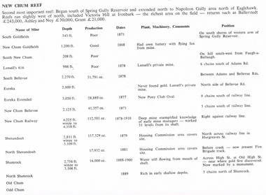
Document - LONG GULLY HISTORY GROUP COLLECTION: NEW CHUM REEF
... ... New Chum Goldfields... South...Mines mentioned are: South Goldfields, New Chum Goldfields, South New Chum, Lansell's 616, South Bellevue, Eureka, Eureka Extended, New Chum Bellevue, New chum Railway, Shenandoah, North Shenandoah, Shamrock, Old Chum, Little Chum, Young Chum, Craven, Garibaldi, Ellesmere, South Old Chum, New Chum Consolidated, North Ellesmere, New Chum United, Lansell's 222, Lansell's Fortuna, Lazarus, West End, Pioneer, Old Chum, New Chum Victoria, North Old Chum, Lansell's Big 180, Sterry, Victoria Quartz, South Adventure, Great Central Victoria, Ballerstedt No 3, Adventure, Humbold, British and American, Midway, Victoria Consuls, Victoria absorbed by Ironbark, Hercules and Energetic, Victoria Pilot, North Hercules and Energetic, Great Extended Hercules, Pearl, Southern Victoria, Great Extended Victoria, Young Victoria, New Catherine Victoria, Weatern Victoria, New Victoria St Mungo, Surprise, Mystery, Duke of Edinburgh, New St Mungo, Duchess Tribute, South Devonshire, Duchess of Edinburgh, West United Devonshire, Albert, United Devonshire, Saxon and Celt, Hopewell, Prince of Wales, Phoenix, Unicorn, South St Mungo, Princess Alice, Lady Barkly, North Devonshire, Ranzeau, St Mungo, Dublin and Cornwall, Sadowa, Eastwood, Ellenborough, Belmont and Saxeby, Snobs Hill, York and Durham, La bElle, Old Williams United, Arcadia, Williams United, South Catherine, Central Catherine, Catherine United, Murchison, New Franklin, Catherine Extended, Pony Club Oval, Housing Commission, Mt Alvernia Hospital, Fortuna, Lunt, Army Survey Unit, Wybrandt, John Brown Factory, Canterbury, Hercules and Energetic and the North Red White and Blue....History House 11 Mackenzie Street Bendigo goldfields BENDIGO History long gully history group The Long Gully History Group - New Chum Reef Ballerstedt Ashley and Noy Grant South Goldfields New Chum Goldfields South New Chum Lansell's 616 South Bellevue Eureka Eureka Extended New Chum Bellevue New chum Railway Shenandoah North Shenandoah Shamrock Old Chum Little Chum Young Chum Craven Garibaldi Ellesmere South Old Chum New Chum Consolidated North Ellesmere New Chum United Lansell's 222 Lansell's Fortuna Lazarus West End Pioneer Old Chum New Chum Victoria North Old Chum Lansell's Big 180 Sterry Victoria Quartz South Adventure Great Central Victoria Ballerstedt No 3 Adventure Humbold British and American Midway Victoria Consuls Victoria absorbed by Ironbark Hercules and Energetic Victoria Pilot North Hercules and Energetic Great Extended Hercules Pearl Southern Victoria Great Extended Victoria Young Victoria New Catherine Victoria Weatern Victoria New Victoria St Mungo Surprise Mystery Duke of Edinburgh New St Mungo Duchess Tribute South Devonshire Duchess of Edinburgh West United Devonshire Albert United Devonshire Saxon and Celt Hopewell Prince of Wales Phoenix Unicorn South St Mungo Princess Alice Lady Barkly North Devonshire Ranzeau St Mungo Dublin and Cornwall Sadowa Eastwood Ellenborough Belmont and Saxeby Snobs Hill York and Durham La bElle Old Williams United Arcadia Williams United South Catherine Central Catherine Catherine United Murchison New Franklin Catherine Extended Pony Club Oval Housing Commission Mt Alvernia Hospital Fortuna Lunt Army Survey Unit Wybrandt John Brown Factory Canterbury Hercules and Energetic North Red White and Blue Six pages titled New Chum Reef. ...Six pages titled New Chum Reef. No number on the first page, the others are 109 to 113. Mentions location of the reef and some of the rich mines. The mines are mentioned in a table with the Name of Mine; Depth; Production; Dates; Plant, Machinery, Comments and Position. Ballerstedt, Ashley and Noy, and Grant were three of the successful miners. Mines mentioned are: South Goldfields, New Chum Goldfields, South New Chum, Lansell's 616, South Bellevue, Eureka, Eureka Extended, New Chum Bellevue, New chum Railway, Shenandoah, North Shenandoah, Shamrock, Old Chum, Little Chum, Young Chum, Craven, Garibaldi, Ellesmere, South Old Chum, New Chum Consolidated, North Ellesmere, New Chum United, Lansell's 222, Lansell's Fortuna, Lazarus, West End, Pioneer, Old Chum, New Chum Victoria, North Old Chum, Lansell's Big 180, Sterry, Victoria Quartz, South Adventure, Great Central Victoria, Ballerstedt No 3, Adventure, Humbold, British and American, Midway, Victoria Consuls, Victoria absorbed by Ironbark, Hercules and Energetic, Victoria Pilot, North Hercules and Energetic, Great Extended Hercules, Pearl, Southern Victoria, Great Extended Victoria, Young Victoria, New Catherine Victoria, Weatern Victoria, New Victoria St Mungo, Surprise, Mystery, Duke of Edinburgh, New St Mungo, Duchess Tribute, South Devonshire, Duchess of Edinburgh, West United Devonshire, Albert, United Devonshire, Saxon and Celt, Hopewell, Prince of Wales, Phoenix, Unicorn, South St Mungo, Princess Alice, Lady Barkly, North Devonshire, Ranzeau, St Mungo, Dublin and Cornwall, Sadowa, Eastwood, Ellenborough, Belmont and Saxeby, Snobs Hill, York and Durham, La bElle, Old Williams United, Arcadia, Williams United, South Catherine, Central Catherine, Catherine United, Murchison, New Franklin, Catherine Extended, Pony Club Oval, Housing Commission, Mt Alvernia Hospital, Fortuna, Lunt, Army Survey Unit, Wybrandt, John Brown Factory, Canterbury, Hercules and Energetic and the North Red White and Blue.bendigo, history, long gully history group, the long gully history group - new chum reef, ballerstedt, ashley and noy, grant, south goldfields, new chum goldfields, south new chum, lansell's 616, south bellevue, eureka, eureka extended, new chum bellevue, new chum railway, shenandoah, north shenandoah, shamrock, old chum, little chum, young chum, craven, garibaldi, ellesmere, south old chum, new chum consolidated, north ellesmere, new chum united, lansell's 222, lansell's fortuna, lazarus, west end, pioneer, old chum, new chum victoria, north old chum, lansell's big 180, sterry, victoria quartz, south adventure, great central victoria, ballerstedt no 3, adventure, humbold, british and american, midway, victoria consuls, victoria absorbed by ironbark, hercules and energetic, victoria pilot, north hercules and energetic, great extended hercules, pearl, southern victoria, great extended victoria, young victoria, new catherine victoria, weatern victoria, new victoria st mungo, surprise, mystery, duke of edinburgh, new st mungo, duchess tribute, south devonshire, duchess of edinburgh, west united devonshire, albert, united devonshire, saxon and celt, hopewell, prince of wales, phoenix, unicorn, south st mungo, princess alice, lady barkly, north devonshire, ranzeau, st mungo, dublin and cornwall, sadowa, eastwood, ellenborough, belmont and saxeby, snobs hill, york and durham, la belle, old williams united, arcadia, williams united, south catherine, central catherine, catherine united, murchison, new franklin, catherine extended, pony club oval, housing commission, mt alvernia hospital, fortuna, lunt, army survey unit, wybrandt, john brown factory, canterbury, hercules and energetic, north red white and blue -
 Bendigo Historical Society Inc.
Document - MINING REPORTS - DIAMOND HILL - NELL GWYNNE LINE
... ... Goldfields Ext'd... South...Mines mentioned are:- North Bendigo, Nell Gwynne, Goldfields North, Goldfields Ext'd, South Concord and the Concord....Mines mentioned are:- North Bendigo, Nell Gwynne, Goldfields North, Goldfields Ext'd, South Concord and the Concord. Document MINING REPORTS - DIAMOND HILL - NELL GWYNNE LINE ...Handwritten notes with name of mine, height of sill and depth of bottom level. Four mines have the name of a gully beside them. Mines mentioned are:- North Bendigo, Nell Gwynne, Goldfields North, Goldfields Ext'd, South Concord and the Concord.document, gold, mining reports, diamond hill nell gwynne line, north bendigo, nell gwynne, goldfields north, goldfields ext'd, south concord, concord -
 Bendigo Historical Society Inc.
Document - MINING REPORTS - FOURTH COMPARTMENT INTRODUCED
... ... Goldfields South...History House 11 Mackenzie Street Bendigo goldfields DOCUMENT Gold Mining Reports Fourth Compartment Introduced Mines Report 1909 page 117 Hustlers Reef No 1 Park Shaft New Chum Goldfields Goldfields South North Central Nell Gwynne Nell Gwynne Goldfields Consolidated Goldfields North New Bendigo Goldfields Propy Nell Gwynne Bdgo G'Fields Propy Goldfields Extended South Concord Lansell's Concord South Red White & Blue North Red White & Blue Victoria Quartz Victoria Consols Lazarus New Chum & Victoria Carlisle Cornish United United Ulster South Concord New Chum Railway Red White & Blue Ext'd New Golden Fleece North New Moon New Moon South Moon Clarence United New Argus Specimen Hill Williams United Golden Age (Shellback Shaft) Johnsons No 2 Confidence Ext'd Callman & Tachhi Needle Shaft Catherine Reef Ext'd Bruhn's Consolidated New Argus New Prince of Wales Handwritten list of mines in Bendigo and Eaglehawk with the depth when the fourth compartment was introduced. ...Handwritten list of mines in Bendigo and Eaglehawk with the depth when the fourth compartment was introduced. Number of Shafts with fourth Compartment. Total at end of year 1908, 22, total at end of year 1909 - 42 - or an increase of 20 for the year. This is approximately 40% of all the working shafts on the year.document, gold, mining reports, fourth compartment introduced, mines report 1909 page 117, hustlers reef no 1 park shaft, new chum goldfields, goldfields south, north, central nell gwynne, nell gwynne, goldfields consolidated, goldfields north, new bendigo goldfields propy, nell gwynne bdgo g'fields propy, goldfields extended, south concord, lansell's concord, south red white & blue, north red white & blue, victoria quartz, victoria consols, lazarus, new chum & victoria, carlisle, cornish united, united ulster, south concord, new chum railway, red, white & blue ext'd, new golden fleece, north new moon, new moon, south moon, clarence united, new argus, specimen hill, williams united, golden age (shellback shaft), johnsons no 2, confidence ext'd, callman & tachhi, needle shaft, catherine reef ext'd, bruhn's consolidated, new argus, new prince of wales -
 Bendigo Historical Society Inc.
Document - The Ninnes Grave, Robin Hill Estate. 150th Anniversary with family history notes
... Document broken up into subheadings - 'Coming to Australia', 'To the Goldfields', 'Life in South Australia', 'The Headstone and the Grave', and 'For Consideration'....Document broken up into subheadings - 'Coming to Australia', 'To the Goldfields', 'Life in South Australia', 'The Headstone and the Grave', and 'For Consideration'. ...Single A4 page. Relates to the Ninnes Grave, Robin Hill Estate, Bendigo. 150 Anniversary. Typed notes. Defines the history of the Ninnes family from Cornwall. Document broken up into subheadings - 'Coming to Australia', 'To the Goldfields', 'Life in South Australia', 'The Headstone and the Grave', and 'For Consideration'.ninnes grave, robin hill estate -
 Federation University Historical Collection
Object - Candle Remnant, Candle remnant from early Two Ballarat mines, c1860 ?
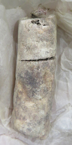
... Picked up by Donald Doyles Mather whilst cleaning out Ballarat South Goldfield Co's Leviathan Shaft when reopening "Great Leviathan in in the year 1948. ...Barker Library (top floor) Mount Helen goldfields From the Britannia Mine (Ballarat) Candle remnants from early Ballarat mines are quite rare. mining candle lard great leviathan donald mather cambrian hill great leviathan quartz mining company .2) Piece of Candle The Great Leviathan Quartz Mining CosMine at Cambrian Hill near Ballarat. Picked up by Donald Doyles Mather whilst cleaning out Ballarat South ...From the Britannia Mine (Ballarat) Candle remnants from early Ballarat mines are quite rare..1) White/cream candle remnant. Candle mold seams are evident. Stored in green pharmaceutical tin with screw lid. (?) Found when removing for filling motor spaces Camp Street. .2) white candle remnant from the Britannia Mine at Cambrian Hill held in a 'Barker Cake Container; tin. A handwritten note inside the tin indicates 'Piece of Candle from Mullock's Britannia Mine. Ballarat. .2) Piece of Candle The Great Leviathan Quartz Mining CosMine at Cambrian Hill near Ballarat. Picked up by Donald Doyles Mather whilst cleaning out Ballarat South Goldfield Co's Leviathan Shaft when reopening "Great Leviathan in in the year 1948. The candle was last used by miners in the Great Leviathan in the drive where found Year G. Leviathan Closed down "______" mining, candle, lard, great leviathan, donald mather, cambrian hill, great leviathan quartz mining company -
 Bendigo Historical Society Inc.
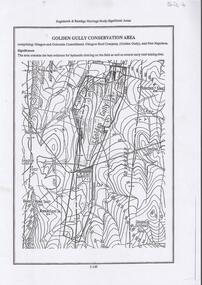
Document - DIAMOND HILL, GOLDEN GULLY COSERVATION AREA
... The area is significant because it contains the 'best evidence for hydraulic sluicing on the field as well as several early reef mining sites' On top of page 'Eaglehawk & Bendigo Heritage Study, Significant areas' Mines marked on page: Goldfields Extended shaft South Concord shaft Concord shaft Morning Light shaft Hansel and Mundy shaft...The area is significant because it contains the 'best evidence for hydraulic sluicing on the field as well as several early reef mining sites' On top of page 'Eaglehawk & Bendigo Heritage Study, Significant areas' Mines marked on page: Goldfields Extended shaft South Concord shaft Concord shaft Morning Light shaft Hansel and Mundy shaft Document DIAMOND HILL, GOLDEN GULLY COSERVATION AREA ...Map of Golden Gully conservation area comprising Glasgow and Golconda Consolidated, Glasgow Reef Company (Golden Gully) and New Napoleon. The area is significant because it contains the 'best evidence for hydraulic sluicing on the field as well as several early reef mining sites' On top of page 'Eaglehawk & Bendigo Heritage Study, Significant areas' Mines marked on page: Goldfields Extended shaft South Concord shaft Concord shaft Morning Light shaft Hansel and Mundy shaftbendigo, mining, golden gully -
 Bendigo Historical Society Inc.
Photograph - Aerial photographs of parts of Bendigo 1934, 1934
... The photos cover the City Centre and are mainly of the goldfields on the south side of the city; the extent of which covers approximately the four corners of Myers Flat, Maiden Gully, Mandurang and One Tree Hill. ...The photos cover the City Centre and are mainly of the goldfields on the south side of the city; the extent of which covers approximately the four corners of Myers Flat, Maiden Gully, Mandurang and One Tree Hill. ...AERIAL SHOTS OF PARTS OF BENDIGO 1934 Catalogue No.10584 This document contains scans of a unique set of aerial photographs that were taken over the City of Bendigo on Friday 12th January 1934, at about midday. The photographs were commissioned by Bendigo Mines Limited during their exploration and mining program designed to revitalize the Bendigo Goldfield. The photographs were given to the Victorian Mines Department sometime in the 1950s. The photographs were taken at a relatively low level of about 4000 feet. This gives a very detailed picture of Bendigo as it was in the 1930s. The photos cover the City Centre and are mainly of the goldfields on the south side of the city; the extent of which covers approximately the four corners of Myers Flat, Maiden Gully, Mandurang and One Tree Hill. Streets, roads and places of interest have been identified as best as possible in December 2023. There are 44 maps, and each references the adjoining maps.Typed Notes with CD The CD is one of two and contains a set of 46 images: The folder named "High_Resolution_800dpi" contains the original digital files that were produced by scanning the photographic prints (About A3 size) at 800 dpi using a high quality, large pformat, roll scanner. These files may be too large for some computers. A second CD contains a direstory called "Low_Resolution_300dep" The images in the folder names "Low_Reolution_300dpr" have a lower resolution (300 dpi) and have been rotated 90 degrees clockwise so that the Northern margin of each image is a the top of the screen. Clive Willman Senior Geologist Geological Survey of Victoriahistory, bendigo, bendigo mines, bendigo maps, bendigo aerial photos -
 Warrnambool and District Historical Society Inc.
Book, The Miner’s Right, 1922
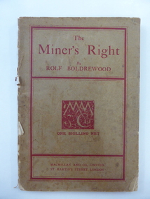
... This book about the New South Wales goldfields was written by Rolf Boldrewood in 1890. ...Warrnambool and District Historical Society Inc. 2 Gilles Street (south of Merri St) Warrnambool great-ocean-road This book about the New South Wales goldfields was written by Rolf Boldrewood in 1890. ...This book about the New South Wales goldfields was written by Rolf Boldrewood in 1890. It is retained because the author played a significant part in Warrnambool’s history. Rolf Boldrewood, the pen name of Thomas Browne, first came to the Warrnambool district in 1842, visiting the Bolden brothers’ property, Grasmere. He camped on the banks of the Merri River for about six months and described the area, including Warrnambool Bay, some years later in his book Old Melbourne Memories. In 1844 Thomas Browne established the property, Squattleseamere near Bessiebelle, north west of Portland. He remained there for ten years then moved to New South Wales. The last forty years of his life were spent writing and he became well-known for the classic Australian novel, Robbery Under Arms. This book is retained because it is a 19th century example of the writings of Rolf Boldrewood. He is important in Warrnambool’s early history as he was in the area in the early 1840s. His account of the area at that time is the most important one we have of the area that was later to be the site of the new settlement of Warrnambool.This is a soft cover book of 188 pages. The cover is brown with red edging and lettering and is partly detached from the binding. The spine is partly missing. The pages are dog-eared and there is some foxing. The text is printed in two columns to a page. Frank J. Donovanrolf boldrewood (thomas browne), bolden brothers in the warrnambool area, warrnambool history, the miners right -
 Sunshine and District Historical Society Incorporated
Archive - Aboriginal First Nation and Archaelogy
... Newspaper Article Brimbank Independent 6 May 1997 Aboriginal reconciliation meeting at St Albans|Typed Letter 8 June 1982 Victoria Archaelogical Survey|Typed Letter 10 June 1982 Survey of Archaelogical Sites in the Melbourne Metropolitan Area|Newspaper Article Herald Sun 18 September 1994 Before the white man|Newspaper Article Advocate 30 June 1999 We re rockin on Rock of Ages - Volcanic rock from the banks of the Kororoit Creek|Newspaper Article Advocate 20 June 2000 History revealed Aboriginal artefacts on a West Sunshine site|Typed Report First Residents of Melbourne's Western Region by Gary Presland|Brochure First Residents of Melbourne's Western Region by Gary Presland|Flyer The Melbourne and Metropolitan Archaeological Survey|Flyer John Bateman and the Aborigines|Flyer and Time A Celebration of Victoria's Submerged Archaelogical Heritage|Flyer Aborigines in the Gellibrand Hill area|Program 9 Octoberr 1981 Archaelogy|Handmade Map 1997 Brimbank Dreamtime Festival 22nd March 1997 - Map of Festival Layout at Brimbank Park|Newspaper Article Advocate 20 April 2013 Call for leaders to take a stand|Typed Letter 2010 Preliminary Report on Aboriginal Artefacts found in Albion and Ardeer by Robert Jackson|Brimbank Together Yes Acknowledging our history embracing our future poster - Use by Brimbank Council at The Hunt Club Community Centre|Newspaper Article Weekly Times 2 July 2002 A cultural experience for students Maribyrnong Primary School|Newspaper Article Living Museum 10 October 2001 Project forges links between cultures|The Advocate 20th April - Call for leaders to take a stand Colleen Marion|Booklet The Voice to Parliament|Booklet The Voice to Parliament Your Questions answered|Brochure Yes23 It's time to recognise Aboriginal and Torres Strait Islander Peoples in the Consititution throug a voice information sheets|Your official referendum booklet|Flyer How to vote yes campaign cards|Newspaper Article Herald Sun 15 October 2023 Time to Unite after the referendum defeat|Newspaper Article Herald Sun 16 October 2023 How Australia Voted|Brochure Brimbank council wants a better future for Aboriginal and Torres Strait Islander people|Brochure council for Aboriginal Reconciliation Working Together|Email La Trobe University Branch 4 March 2001|Typed Letter 13 March 1991 The Aboriginal Programme Exchange|Typed Letter 20 April 2000 Union of Australian Women|Typed Letter August 2000 Union of Australian Women Newsletter|Magazine Dissent Spring 2000 Aborigines reconciliation racial prejudice|Brochure Talking Together Women and Reconciliation|Brochure A National Action Network|Brochure High Court Decision on Native Title|Brochure Running Discussion Groups|Brochure Dealing with the Media|Brochure Contacts and Resources|Program The Western Metropolitan Region NAIDOC Program 2007|Newspaper Article The Age 25 May 1991 The Jawoyns troubled dreaming|Newsletter AEQUA Equal Employment Opportunity Newsletter 12 August 1981 Aboriginal employment in the APS on the up|Photocopy of Photograph Off Opie Road near Brachnell Place|Brochure Brimbank News Issue 10 2023 Be Bold Festival 7 October 2023|Typed Notes Uluru Statement from the Heart|Newspaper Article The Age 18 January 2001 William Barak|Newspaper Article The Star 17th October 2006 Special day for youth Karen Jackson|Newspaper Article Lalor Star March 1980 Aboriginal Treaty|Typed Letter Womens International Leagure for Peace and Freedom November 1979|Newspaper Article The Age 17 April 1997 Rednecks using Wik debate to grab new rights|Flyer Support Workers Claims for Stolen Wages and Return the Stolen wages for Workers and their families and Support Wage Justice Return the Stolen Wages|Handwritten Letter from Leo Prestia 27 January|List of Aboriginal Organisatons February 2004|Newspaper Article A Saturday Reflection|Postcard Pitchi Richi Sanctuary Alice Springs|Postcard Pitchi Richi Sanctuary Alice Spring|Invitation The Mayor and Councillors of Moreland City Council Connections Land and people|Notes Address Selina Aborignes|Booklet Recognition The Way forward An Issues paper from the Ausralian Catholic Social Justice Council|Newspaper Article The Age 21 January 1980 Signs of ancient man found in threatened valley|Form Australians for Native title reconciliation|Booklet Vic Uni News June 1997 Jindi woraback joining together|Newspaper Article The Age 17 April 1997 Black network hears Wik plan|Booklet Australian Institute for a Just Sustainable Peaceful Future Native Title Implications for Land management April 1997 Discussion Paper Number 11|Typed Notes Parliament of Australia Department of the Parliamentary Library current Information Digest Education and Welfare 14 January 1973 Aborigines Government Policy|Koori music and the Multicultural choir 13 July|Typed Notes 4 February 2004|Flyer State of Shock A new film by David Bradbury|Newspaper Article 21 October 1997 The Age Metro Arts and Life Heritage voting for a Trust you can trust6|Typed Letter from Parliament of Australia The Senate Hon Margaret Reynolds 15 September 1997 Native title Amendment bill 1997|Typed notes What are the International implications of Australias proposed legislative response to the Wik decision 16 May 1997|Newspaper Article The Age 11 October 1980 CRA and the Aborigines|Newspaper Article The Age 27 October 1980 Lost languages of the Aborigine|Program Western Metropolitan Region NAIDOC Committee 6 October 2004|Typed Notes How the English Language is used to put Aborigines down Deny us rights or Is Employed as a Political Tool Against Us|Flyer Australias for Reconciliation Study Circle The Footscray Community Arts Centre|Newspaper Article Weekly Times 4 December 2001 Smoking marks opening|Flyer Save The Racial Discrimination Act The Law for All of Us|Flyer Freedom fund for 1988 Dont Celebrate 1988 White Australia Has a Black History|Typed Notes 4 May 1997 Area Meeting on Aboriginal Reconciliation 20 May 1997 Why Reconciliation|Newspaper Article Sunday Press 17 July 1988 Hes black hes white and hes Browned off|Handwritten list Morning Tea with Yolande Klempprier 5 December 1979|Typed Notes Interim Consultative Committee Western Region Community Legal Centre|Brochure Aboriginal Myths and Legends from the Goldfields to the South West of Western Australia|Brochure Messagestick Conserve or Destroy May 1980 Voume 5 No 1|Brochure Aboringinal Women's Task Force "We need to know what you think"|Newspaper Article The Age 27th February 1980 Aboriginal skeleton found by workmen Barries Rd Melton|Newspaper Article 18th September 1985 Only maternal instricts have saved Aboriginal race from destruction says Hollows|Newspaper Article Star Weekly 26th March 2024 New Indigenous name for Sydenham Park "Yaluk barring Park"|Newspaper Article Star Weekly 30th July 2024 - New name for park|Newspaper Artilce 9th January 2024 Abandoning January 26 - Brimbank Council will no longer hold citizenship cermonies on January 26...Aborigine Aboriginal First Nation Newspaper Article Brimbank Independent 6 May 1997 Aboriginal reconciliation meeting at St Albans|Typed Letter 8 June 1982 Victoria Archaelogical Survey|Typed Letter 10 June 1982 Survey of Archaelogical Sites in the Melbourne Metropolitan Area|Newspaper Article Herald Sun 18 September 1994 Before the white man|Newspaper Article Advocate 30 June 1999 We re rockin on Rock of Ages - Volcanic rock from the banks of the Kororoit Creek|Newspaper Article Advocate 20 June 2000 History revealed Aboriginal artefacts on a West Sunshine site|Typed Report First Residents of Melbourne's Western Region by Gary Presland|Brochure First Residents of Melbourne's Western Region by Gary Presland|Flyer The Melbourne and Metropolitan Archaeological Survey|Flyer John Bateman and the Aborigines|Flyer and Time A Celebration of Victoria's Submerged Archaelogical Heritage|Flyer Aborigines in the Gellibrand Hill area|Program 9 Octoberr 1981 Archaelogy|Handmade Map 1997 Brimbank Dreamtime Festival 22nd March 1997 - Map of Festival Layout at Brimbank Park|Newspaper Article Advocate 20 April 2013 Call for leaders to take a stand|Typed Letter 2010 Preliminary Report on Aboriginal Artefacts found in Albion and Ardeer by Robert Jackson|Brimbank Together Yes Acknowledging our history embracing our future poster - Use by Brimbank Council at The Hunt Club Community Centre|Newspaper Article Weekly Times 2 July 2002 A cultural experience for students Maribyrnong Primary School|Newspaper Article Living Museum 10 October 2001 Project forges links between cultures|The Advocate 20th April - Call for leaders to take a stand Colleen Marion|Booklet The Voice to Parliament|Booklet The Voice to Parliament Your Questions answered|Brochure Yes23 It's time to recognise Aboriginal and Torres Strait Islander Peoples in the Consititution throug a voice information sheets|Your official referendum booklet|Flyer How to vote yes campaign cards|Newspaper Article Herald Sun 15 October 2023 Time to Unite after the referendum defeat|Newspaper Article Herald Sun 16 October 2023 How Australia Voted|Brochure Brimbank council wants a better future for Aboriginal and Torres Strait Islander people|Brochure council for Aboriginal Reconciliation Working Together|Email La Trobe University Branch 4 March 2001|Typed Letter 13 March 1991 The Aboriginal Programme Exchange|Typed Letter 20 April 2000 Union of Australian Women|Typed Letter August 2000 Union of Australian Women Newsletter|Magazine Dissent Spring 2000 Aborigines reconciliation racial prejudice|Brochure Talking Together Women and Reconciliation|Brochure A National Action Network|Brochure High Court Decision on Native Title|Brochure Running Discussion Groups|Brochure Dealing with the Media|Brochure Contacts and Resources|Program The Western Metropolitan Region NAIDOC Program 2007|Newspaper Article The Age 25 May 1991 The Jawoyns troubled dreaming|Newsletter AEQUA Equal Employment Opportunity Newsletter 12 August 1981 Aboriginal employment in the APS on the up|Photocopy of Photograph Off Opie Road near Brachnell Place|Brochure Brimbank News Issue 10 2023 Be Bold Festival 7 October 2023|Typed Notes Uluru Statement from the Heart|Newspaper Article The Age 18 January 2001 William Barak|Newspaper Article The Star 17th October 2006 Special day for youth Karen Jackson|Newspaper Article Lalor Star March 1980 Aboriginal Treaty|Typed Letter Womens International Leagure for Peace and Freedom November 1979|Newspaper Article The Age 17 April 1997 Rednecks using Wik debate to grab new rights|Flyer Support Workers Claims for Stolen Wages and Return the Stolen wages for Workers and their families and Support Wage Justice Return the Stolen Wages|Handwritten Letter from Leo Prestia 27 January|List of Aboriginal Organisatons February 2004|Newspaper Article A Saturday Reflection|Postcard Pitchi Richi Sanctuary Alice Springs|Postcard Pitchi Richi Sanctuary Alice Spring|Invitation The Mayor and Councillors of Moreland City Council Connections Land and people|Notes Address Selina Aborignes|Booklet Recognition The Way forward An Issues paper from the Ausralian Catholic Social Justice Council|Newspaper Article The Age 21 January 1980 Signs of ancient man found in threatened valley|Form Australians for Native title reconciliation|Booklet Vic Uni News June 1997 Jindi woraback joining together|Newspaper Article The Age 17 April 1997 Black network hears Wik plan|Booklet Australian Institute for a Just Sustainable Peaceful Future Native Title Implications for Land management April 1997 Discussion Paper Number 11|Typed Notes Parliament of Australia Department of the Parliamentary Library current Information Digest Education and Welfare 14 January 1973 Aborigines Government Policy|Koori music and the Multicultural choir 13 July|Typed Notes 4 February 2004|Flyer State of Shock A new film by David Bradbury|Newspaper Article 21 October 1997 The Age Metro Arts and Life Heritage voting for a Trust you can trust6|Typed Letter from Parliament of Australia The Senate Hon Margaret Reynolds 15 September 1997 Native title Amendment bill 1997|Typed notes What are the International implications of Australias proposed legislative response to the Wik decision 16 May 1997|Newspaper Article The Age 11 October 1980 CRA and the Aborigines|Newspaper Article The Age 27 October 1980 Lost languages of the Aborigine|Program Western Metropolitan Region NAIDOC Committee 6 October 2004|Typed Notes How the English Language is used to put Aborigines down Deny us rights or Is Employed as a Political Tool Against Us|Flyer Australias for Reconciliation Study Circle The Footscray Community Arts Centre|Newspaper Article Weekly Times 4 December 2001 Smoking marks opening|Flyer Save The Racial Discrimination Act The Law for All of Us|Flyer Freedom fund for 1988 Dont Celebrate 1988 White Australia Has a Black History|Typed Notes 4 May 1997 Area Meeting on Aboriginal Reconciliation 20 May 1997 Why Reconciliation|Newspaper Article Sunday Press 17 July 1988 Hes black hes white and hes Browned off|Handwritten list Morning Tea with Yolande Klempprier 5 December 1979|Typed Notes Interim Consultative Committee Western Region Community Legal Centre|Brochure Aboriginal Myths and Legends from the Goldfields to the South West of Western Australia|Brochure Messagestick Conserve or Destroy May 1980 Voume 5 No 1|Brochure Aboringinal Women's Task Force "We need to know what you think"|Newspaper Article The Age 27th February 1980 Aboriginal skeleton found by workmen Barries Rd Melton|Newspaper Article 18th September 1985 Only maternal instricts have saved Aboriginal race from destruction says Hollows|Newspaper Article Star Weekly 26th March 2024 New Indigenous name for Sydenham Park "Yaluk barring Park"|Newspaper Article Star Weekly 30th July 2024 - New name for park|Newspaper Artilce 9th January 2024 Abandoning January 26 - Brimbank Council will no longer hold citizenship cermonies on January 26 Collection documents relating to Aboriginal First Nation and Archaelogy in the district Archive Aboriginal First Nation and Archaelogy ...Newspaper Article Brimbank Independent 6 May 1997 Aboriginal reconciliation meeting at St Albans|Typed Letter 8 June 1982 Victoria Archaelogical Survey|Typed Letter 10 June 1982 Survey of Archaelogical Sites in the Melbourne Metropolitan Area|Newspaper Article Herald Sun 18 September 1994 Before the white man|Newspaper Article Advocate 30 June 1999 We re rockin on Rock of Ages - Volcanic rock from the banks of the Kororoit Creek|Newspaper Article Advocate 20 June 2000 History revealed Aboriginal artefacts on a West Sunshine site|Typed Report First Residents of Melbourne's Western Region by Gary Presland|Brochure First Residents of Melbourne's Western Region by Gary Presland|Flyer The Melbourne and Metropolitan Archaeological Survey|Flyer John Bateman and the Aborigines|Flyer and Time A Celebration of Victoria's Submerged Archaelogical Heritage|Flyer Aborigines in the Gellibrand Hill area|Program 9 Octoberr 1981 Archaelogy|Handmade Map 1997 Brimbank Dreamtime Festival 22nd March 1997 - Map of Festival Layout at Brimbank Park|Newspaper Article Advocate 20 April 2013 Call for leaders to take a stand|Typed Letter 2010 Preliminary Report on Aboriginal Artefacts found in Albion and Ardeer by Robert Jackson|Brimbank Together Yes Acknowledging our history embracing our future poster - Use by Brimbank Council at The Hunt Club Community Centre|Newspaper Article Weekly Times 2 July 2002 A cultural experience for students Maribyrnong Primary School|Newspaper Article Living Museum 10 October 2001 Project forges links between cultures|The Advocate 20th April - Call for leaders to take a stand Colleen Marion|Booklet The Voice to Parliament|Booklet The Voice to Parliament Your Questions answered|Brochure Yes23 It's time to recognise Aboriginal and Torres Strait Islander Peoples in the Consititution throug a voice information sheets|Your official referendum booklet|Flyer How to vote yes campaign cards|Newspaper Article Herald Sun 15 October 2023 Time to Unite after the referendum defeat|Newspaper Article Herald Sun 16 October 2023 How Australia Voted|Brochure Brimbank council wants a better future for Aboriginal and Torres Strait Islander people|Brochure council for Aboriginal Reconciliation Working Together|Email La Trobe University Branch 4 March 2001|Typed Letter 13 March 1991 The Aboriginal Programme Exchange|Typed Letter 20 April 2000 Union of Australian Women|Typed Letter August 2000 Union of Australian Women Newsletter|Magazine Dissent Spring 2000 Aborigines reconciliation racial prejudice|Brochure Talking Together Women and Reconciliation|Brochure A National Action Network|Brochure High Court Decision on Native Title|Brochure Running Discussion Groups|Brochure Dealing with the Media|Brochure Contacts and Resources|Program The Western Metropolitan Region NAIDOC Program 2007|Newspaper Article The Age 25 May 1991 The Jawoyns troubled dreaming|Newsletter AEQUA Equal Employment Opportunity Newsletter 12 August 1981 Aboriginal employment in the APS on the up|Photocopy of Photograph Off Opie Road near Brachnell Place|Brochure Brimbank News Issue 10 2023 Be Bold Festival 7 October 2023|Typed Notes Uluru Statement from the Heart|Newspaper Article The Age 18 January 2001 William Barak|Newspaper Article The Star 17th October 2006 Special day for youth Karen Jackson|Newspaper Article Lalor Star March 1980 Aboriginal Treaty|Typed Letter Womens International Leagure for Peace and Freedom November 1979|Newspaper Article The Age 17 April 1997 Rednecks using Wik debate to grab new rights|Flyer Support Workers Claims for Stolen Wages and Return the Stolen wages for Workers and their families and Support Wage Justice Return the Stolen Wages|Handwritten Letter from Leo Prestia 27 January|List of Aboriginal Organisatons February 2004|Newspaper Article A Saturday Reflection|Postcard Pitchi Richi Sanctuary Alice Springs|Postcard Pitchi Richi Sanctuary Alice Spring|Invitation The Mayor and Councillors of Moreland City Council Connections Land and people|Notes Address Selina Aborignes|Booklet Recognition The Way forward An Issues paper from the Ausralian Catholic Social Justice Council|Newspaper Article The Age 21 January 1980 Signs of ancient man found in threatened valley|Form Australians for Native title reconciliation|Booklet Vic Uni News June 1997 Jindi woraback joining together|Newspaper Article The Age 17 April 1997 Black network hears Wik plan|Booklet Australian Institute for a Just Sustainable Peaceful Future Native Title Implications for Land management April 1997 Discussion Paper Number 11|Typed Notes Parliament of Australia Department of the Parliamentary Library current Information Digest Education and Welfare 14 January 1973 Aborigines Government Policy|Koori music and the Multicultural choir 13 July|Typed Notes 4 February 2004|Flyer State of Shock A new film by David Bradbury|Newspaper Article 21 October 1997 The Age Metro Arts and Life Heritage voting for a Trust you can trust6|Typed Letter from Parliament of Australia The Senate Hon Margaret Reynolds 15 September 1997 Native title Amendment bill 1997|Typed notes What are the International implications of Australias proposed legislative response to the Wik decision 16 May 1997|Newspaper Article The Age 11 October 1980 CRA and the Aborigines|Newspaper Article The Age 27 October 1980 Lost languages of the Aborigine|Program Western Metropolitan Region NAIDOC Committee 6 October 2004|Typed Notes How the English Language is used to put Aborigines down Deny us rights or Is Employed as a Political Tool Against Us|Flyer Australias for Reconciliation Study Circle The Footscray Community Arts Centre|Newspaper Article Weekly Times 4 December 2001 Smoking marks opening|Flyer Save The Racial Discrimination Act The Law for All of Us|Flyer Freedom fund for 1988 Dont Celebrate 1988 White Australia Has a Black History|Typed Notes 4 May 1997 Area Meeting on Aboriginal Reconciliation 20 May 1997 Why Reconciliation|Newspaper Article Sunday Press 17 July 1988 Hes black hes white and hes Browned off|Handwritten list Morning Tea with Yolande Klempprier 5 December 1979|Typed Notes Interim Consultative Committee Western Region Community Legal Centre|Brochure Aboriginal Myths and Legends from the Goldfields to the South West of Western Australia|Brochure Messagestick Conserve or Destroy May 1980 Voume 5 No 1|Brochure Aboringinal Women's Task Force "We need to know what you think"|Newspaper Article The Age 27th February 1980 Aboriginal skeleton found by workmen Barries Rd Melton|Newspaper Article 18th September 1985 Only maternal instricts have saved Aboriginal race from destruction says Hollows|Newspaper Article Star Weekly 26th March 2024 New Indigenous name for Sydenham Park "Yaluk barring Park"|Newspaper Article Star Weekly 30th July 2024 - New name for park|Newspaper Artilce 9th January 2024 Abandoning January 26 - Brimbank Council will no longer hold citizenship cermonies on January 26aborigine, aboriginal, first nation -
 Warrnambool and District Historical Society Inc.
Administrative record - Debtors' Ledger, early 20th century
... south of Merri St) Warrnambool great-ocean-road This ledger contains details of debts owed by people in the Warrnambool district. It dates from 1906 to 1916. The compiler of the ledger is unknown. Many of the debtors are Chinese, mostly working as market gardeners in the north Warrnambool area and the debts usually concerned rents and the supply of agricultural items such as chaff. These Chinese, many of whom came from the Victorian goldfields ...This ledger contains details of debts owed by people in the Warrnambool district. It dates from 1906 to 1916. The compiler of the ledger is unknown. Many of the debtors are Chinese, mostly working as market gardeners in the north Warrnambool area and the debts usually concerned rents and the supply of agricultural items such as chaff. These Chinese, many of whom came from the Victorian goldfields, operated market gardens and businesses in the town of Warrnambool from the 1870s to the 1930s or 40s.This ledger is of interest because of the names of people listed as debtors and in particular the names of Chinese working in the district. The ledger is thus a valuable research tool. This is a ledger with a thick card cover in a mottled pattern in red, black, blue and yellow colours The spine, which has some damage, is covered in a maroon coloured leather. The pages are ruled with red lines and the entries are handwritten in ink. There are some loose pages.Debtor's Ledger C.L.warrnambool chinese market gardeners, warrnambool, chinese -
 Warrnambool and District Historical Society Inc.
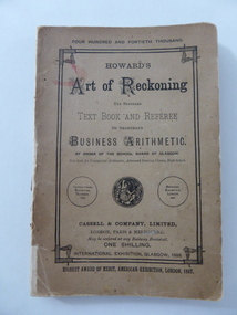
Book, Howard's Art of Reckoning, 1892
... goldfields of U.S.A. and a bigamous marriage he published ‘The Art of Reckoning’ which was highly successful in Britain and U.S.A. He was able to pay back the money he had embezzled. He advertised that he was a Fellow of the Society of Science, Letters and Art, London, but this was a profit-making society owned by an individual and enabled members to wear academic dress and use the title of ‘Professor’. Ostler had in reality no academic qualifications. In the early 1890s he lectured on his ideas on mathematical calculation and publicized his four books in India, Egypt, Palestine and South...south of Merri St) Warrnambool great-ocean-road This book was written by C. Frusher Howard in 1874 and this copy is the 1892 edition. C. Frusher Howard was the alias of Joseph Ostler (‘Frusher’ was his mother’s maiden name) and he was the first district secretary of the Moorabbin Roads Board. He absconded with its funds in 1867. After some time in the goldfields ...This book was written by C. Frusher Howard in 1874 and this copy is the 1892 edition. C. Frusher Howard was the alias of Joseph Ostler (‘Frusher’ was his mother’s maiden name) and he was the first district secretary of the Moorabbin Roads Board. He absconded with its funds in 1867. After some time in the goldfields of U.S.A. and a bigamous marriage he published ‘The Art of Reckoning’ which was highly successful in Britain and U.S.A. He was able to pay back the money he had embezzled. He advertised that he was a Fellow of the Society of Science, Letters and Art, London, but this was a profit-making society owned by an individual and enabled members to wear academic dress and use the title of ‘Professor’. Ostler had in reality no academic qualifications. In the early 1890s he lectured on his ideas on mathematical calculation and publicized his four books in India, Egypt, Palestine and South Africa. In 1896 he returned to Australia and at the 1896-7 Warrnambool Industrial and Art Exhibition Howard gave daily lectures on mathematical calculations and illustrated these with the aid of a blackboard. The inscription in this book does not appear to have any local significance but the book is of interest because the author, C. Frusher Howard, was a lecturer at the Warrnambool Industrial and Art Exhibition of 1896-7. This is a soft cover book of 142 pages. There are several pages at the back of the book advertising other books published by Cassell and Company. The cover is brown with an ornate border on the front cover and black printing on the front cover, spine and back cover. The lettering on the spine has been mostly worn away. The first page has a black and white sketch of the author, C. Frusher Howard, in academic dress. The inscription is handwritten in black ink. ‘C.F. Hamilton, South Heathcote, 1893’ c. frusher howard (joseph ostler), joseph ostler, c. frusher howard -
 Bendigo Military Museum
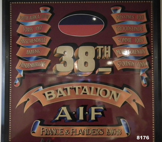
Honour Board - 38th BN BATTLE HONOURS, Unknown
... Bendigo Military Museum 37 - 39 Pall Mall Bendigo goldfields This board shows there are 7 Battle Honours which includes South Africa 1898 - 1902. ...This board shows there are 7 Battle Honours which includes South Africa 1898 - 1902. This is due to Lineage pre the formation of the 38th BN in June 1916 in Bendigo. Refer Cat No 4435 for the actual 38th Bn Colours. This item is on display in the rear foyer entrance of the Bendigo District RSL in Havilah Road. Refer Cat No 8141P for the history of donation and placement across the RSL.Large board with brown/red background with ornate edge all round, each side are the Battle Honours of the Battalion in scroll formation, at the top central is the Colour Patch of the Battalion, the “38th” under that then”Battalion AIF”, at the bottom in a scroll is “France & Flanders 1916 - 18”brsl, smirsl, bdrslinc, 38th, battle honours -
 Bendigo Military Museum
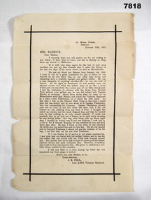
Letter - LETTER OF CONDOLENCE, Q.M.S. J.K. Paul, Victorian Regiment, 11 Jan 1901
... goldfields Letter in relation to unidentified soldier. Son of Mrs. Barbour, presumably a member of the Victorian Regiment, who died of illness during the Boer War during the year of 1900 in South Africa. ...Letter in relation to unidentified soldier. Son of Mrs. Barbour, presumably a member of the Victorian Regiment, who died of illness during the Boer War during the year of 1900 in South Africa. Believed to be Private Robert Barbour S/N 94, who died of Enteric Fever at Bloemfontein on 6 May 1900.Faded white paper with black borders. Detailed black typed letter outlining last days of the son of Mrs Barbour who died from illness in the Boer War.boer war, 1900, letter of condolence, disease, private barbour -
 Warrnambool and District Historical Society Inc.
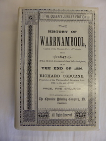
Book, The History of Warrnambool by Richard Osburne, 1980
... Warrnambool and District Historical Society Inc. 2 Gilles Street (south of Merri St) Warrnambool great-ocean-road Richard Osburne (1825-1895) came to Warrnambool in 1847, a pioneer resident in the new settlement. In 1851, with John Wilkinson, he founded Warrnambool’s first newspaper, the Warrnambool Examiner, and issued it weekly for some months until he left the town for the goldfields. ...Richard Osburne (1825-1895) came to Warrnambool in 1847, a pioneer resident in the new settlement. In 1851, with John Wilkinson, he founded Warrnambool’s first newspaper, the Warrnambool Examiner, and issued it weekly for some months until he left the town for the goldfields. Returning in 1853 he resumed publication of the Examiner and continued it, intermittently in its last few years, until 1880. He was acknowledged in his day as the Father of the Warrnambool Press and was a dominant figure in Warrnambool’s early history. He was associated with the establishment of the Aboriginal Reserves, Fire Brigade, Mechanics’ Institute, Warrnambool Council, National School, Presbyterian Church, Public Wants Committee, Villiers Building Society, Fish Protection Society, Dramatic Club, Cricket Club, Otway Gold Exploration Syndicate and other institutions. In 1882 he went to live in Melbourne, returning to publish his ‘History of Warrnambool’ in 1887, a Queen’s Jubilee publication. Richard Osburne’s book is a seminal work of the 19th century history of Warrnambool and its importance cannot be over-emphasized. The original copies of this book are now hard to get and are very valuable. This facsimile is kept because the facsimiles are also now becoming rare and they are good examples of the way a facsimile is reproduced and the reason for the existence of this particular reprint– the importance and usefulness of Osburne’s history and the need to make it accessible to researchers today.This is a facsimile edition (1980) of Richard Osburne's book on the history of Warrnambool from 1847 to 1886. It is a hard cover buff-coloured book with gold lettering on the spine. The dust cover is cream-coloured paper with black writing. Inside the cover is a map of southwest Victoria (1880). There are five fold-up inserts (sketches, diagrams etc), a number of business advertisements, sepia photographs and sketches and an index. The dust cover includes information on the author. There are 25 chapters, a foreword by the Prime Minister of Australia, Malcolm Fraser and a Preface The proceeds of the book reprint went to Flagstaff Hill Maritime Village.This is a facsimile edition (1980) of Richard Osburne’s book on the history of Warrnambool from 1847 to 1886. It is a hard cover buff-coloured book with gold lettering on the spine. The dust cover is cream–coloured paper with black writing. Inside the cover is a map of southwest Victoria (1880). There are five fold-up inserts (sketches, diagrams etc), a number of business advertisements, sepia photographs and sketches and an index. The dust cover includes information on the author. There are 25 chapters, a foreword by the Prime Minister of Australia, Malcolm Fraser and a Preface The proceeds of the book reprint went to Flagstaff Hill Maritime Village.richard osburne, the history of warrnambool, warrnambool examiner -
 Warrnambool and District Historical Society Inc.
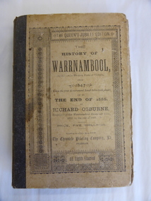
Book, The History of Warrnambool by Richard Osburne, 1887
... Warrnambool and District Historical Society Inc. 2 Gilles Street (south of Merri St) Warrnambool great-ocean-road Richard Osburne (1825-1895) came to Warrnambool in 1847, a pioneer resident in the new settlement. In 1851, with John Wilkinson, he founded Warrnambool’s first newspaper, the Warrnambool Examiner, and issued it weekly for some months until he left the town for the goldfields. ...Richard Osburne (1825-1895) came to Warrnambool in 1847, a pioneer resident in the new settlement. In 1851, with John Wilkinson, he founded Warrnambool’s first newspaper, the Warrnambool Examiner, and issued it weekly for some months until he left the town for the goldfields. Returning in 1853 he resumed publication of the Examiner and continued it, intermittently in its last few years, until 1880. He was acknowledged in his day as the Father of the Warrnambool Press and was a dominant figure in Warrnambool’s early history. In 1882 he went to live in Melbourne, returning to publish his ‘History of Warrnambool’ in 1887.This book is highly significant as it is an original copy of one of the most important books written on Warrnambool’s history by one of Warrnambool’s most important early settlers (published 1887). Original copies are extremely rare now. The book was given to D.B. Sellars by his first cousin, John Murray, who was Warrnambool’s Parliamentary representative for over 30 years and Premier of Victoria from 1909 to 1912. John Murray’s signature is in the book and this is an important addition. The provenance therefore is of the highest significance. No details are available on the recipient of the book or the donor of the book to the Historical Society. This is an original copy of Richard Osburne’s book on the history of Warrnambool from 1847 to 1886. It is a hard cover buff-coloured book of 284 pages with additional Melbourne and Warrnambool advertisements at the book. There is one fold-up insert (four of the original missing) There are a Preface and Notes from the Author ('To the public in general’ and ‘To my personal friends in the Warrnambool district’)Inside front cover: Mr D.B. Sellars from John Murray (in pencil – Premier of Victoria 1909-1912, 1st cousin of D.B.Sellars, Uncle David) Donated to the Historical Society of Warrnambool in memory of Miss Clemintine MacDonald of Maffra, who died April 1979, aged 91 years. Given by Mrs M.Allen (niece) 72 Grange Road, Sandringham, 3191, 22-7-80 john murray, richard osburne, history of warrnambool -
 Warrnambool and District Historical Society Inc.
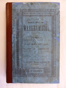
Book, The History of Warrnambool, 1887
... Warrnambool and District Historical Society Inc. 2 Gilles Street (south of Merri St) Warrnambool great-ocean-road Richard Osburne (1825-1895) came to Warrnambool in 1847, a pioneer resident in the new settlement. In 1851 with John Wilkinson, he founded Warrnambool’s first newspaper, the Warrnambool Examiner and issued it weekly for some months until he left the town for the goldfields. ...This is an original copy of Richard Osburne’s book on the history of Warrnambool from 1847 to 1886. It is a hard cover blue-coloured book of 284 pages with additional Melbourne and Warrnambool advertisements at the end of the book. There is one fold-up insert (four of the original are missing). There are a Preface and Notes From the Author (‘To the public in general’ and ‘To my personal friends in the Warrnambool district’). richard osburne, history of warrnambool, warrnambool history, warrnambool 1886 -
 Bendigo Military Museum
Award - MEDAL RIBBON BAR, VIETNAM
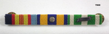
... goldfields Part of the Cooper Collection. Details of "Keith Cooper's" service 3798359. National Service, served Vietnam 12th Field Regt Light Aid detachment (LAD) 11/3/71 - 30/10/71. Signed on into the regular army and served for 25 years. Discharged with the rank of WO.1 class. Cooper Collection Keith Cooper Vietnam War Medal ribbons Award Medal ribbon bar consisting of three ribbons attached to an aluminum strip. The rear has two brass clips. Medals represented L-R: Vietnam Medal, Long Service Medal, South ...Part of the Cooper Collection. Details of "Keith Cooper's" service 3798359. National Service, served Vietnam 12th Field Regt Light Aid detachment (LAD) 11/3/71 - 30/10/71. Signed on into the regular army and served for 25 years. Discharged with the rank of WO.1 class.Medal ribbon bar consisting of three ribbons attached to an aluminum strip. The rear has two brass clips. Medals represented L-R: Vietnam Medal, Long Service Medal, South Vietnam Campaign Medal.cooper collection, keith cooper, vietnam war, medal ribbons, award -
 Bendigo Military Museum
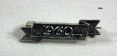
Award - BADGE - SOUTH VIETNAM CAMPAIGN MEDAL, Unknown
... goldfields Part of the Cooper Collection. See Catalogue No. 7868 for details of "Keith Cooper", 3798359 service details. Vietnam War Awards Badge South ...Part of the Cooper Collection. See Catalogue No. 7868 for details of "Keith Cooper", 3798359 service details.Silver coloured metal pin with '1960' embossed on front. Pin and clip attached for fixing to South Vietnam Campaign Medal.Embossed on front "1960".vietnam war, awards, badge, south vietnam campaign metal, cooper collection, keith cooper -
 Bendigo Military Museum
Document - VIETNAM PAPERS - HERDMAN
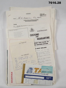
... goldfields 5. Pocketbook issued to Australian Troops during the Vietnam War. Contents include: The War in South Vietnam, The People, Government Services, Armed Services, Viet Cong, Vietnamese Language, Useful information. 14. ...5. Pocketbook issued to Australian Troops during the Vietnam War. Contents include: The War in South Vietnam, The People, Government Services, Armed Services, Viet Cong, Vietnamese Language, Useful information. 14. Details of Australia V US. Hill climb with program of Events, 22nd February 1970. 15. Details of dog races with fields listed on a six race program - 20th February 1970. 18. Document details departure itinerary (ex SVN) for K.J. HERDMAN. 27. Notebook contains names and addresses of US service personnel. Papers related to "Kevin John Herdman's" visit to South Vietnam from 18th February to 4th March 1970. Part of the Kevin John Herdman, No. 397661 Collection. See Cat. No. 5942P for details of his service. 27. Collection of documents related to K.J. Herdman. 1. Two page TAA flight ticket. Text in blue coloured type. Two baggage tickets stapled to front. 2. Single diary page with torn edge. Handwritten flight itinerary in section dated 16th February. 3. Two page QANTAS flight ticket. Text in red and black type. Flight details printed in purple type. 4. Printed flier outlining Australian Customs and Quarantine regulations. Recipient's name handwritten in black ink. 5. Green coloured soft cover pocketbook. 74 pages with cut edges. Black and white diagrams. Text in black type. 6. Small pamphlet with black type. Written in Vietnamese. 7. Foolscap sized 5 page document stapled on top LHC. Text in black type. Title "VISITS BY CMF OFFICERS TO VIETNAM". 8. A4 sized one page document with text in black type on one side only. Two sided pamphlet on blue paper stapled to top LHC. Black type on pamphlet. Title "NINE RULES FOR AUSTRALIAN ARMY FORCES IN VIETNAM." 9. Two page A4 sized document with text in black type. Text on one side of each page. Title "AUSTRALIAN FORCE VIETNAM, RTA BRIEFING NOTES - QANTAS CHARTER, SAIGON/SYDNEY". 10. Foolscap signed proforma oriented in landscape. Title: AUSTRALIAN MILITARY FORCES, VISITS BY CMF OFFICERS TO SYN". Details of personnel in black type. 11. Quarto sized two page document with printing on one side. Text in black type. Staple in top LHC. Title: "CMF VISITOR - LT. K.J. HERDMAN, (ITINERARY FOR LT. K.J. HERDMAN)". 12. Quarto sized two page document with printing on one side. Text in black type. Staple in top LHC. Title: " CMF VISITOR - LT K.J. HERDMAN (ITINERARY FOR LT. K.J.HERDMAN)" 13. A4 sized document with text in black type. Text on one side only. Title: CMF VISITOR - LT. K.J. HERDMAN". 14. Foolscap sized document with text in black type. Printing on one side. Title: "LONG HI HILL CLIMB". 15. Quarto sized document with text in black type. Printing on one side. Title: "DAT DO DOGS". 16. Foolscap sized 9 page document with text on one side. Printing in black type. Pages stapled together in top LHC. Title: "1 ATF G INSTRUCTIONS 14/69, SUPPLIES, POL AND AMMUNITION HOLDINGS". 17. A4 sized document with text on one side. Printing in black type. TITLE; "AMENDMENT 1 TO Q INSTRUCTION 14/69, DATED 23 OCT 69". 18. A4 SIZED DOCUMENT WITH TEXT ON BOTH SIDES. PRINTING IN BLACK TYPE. 19. Foolscap sized 3 page document with staple in top LHC. Text on page 1 in black type. Text on pages 2 & 3 in purple type. Pages are entitled "TEMA FLYING PROGRAMME - CH 47". 20. Foolscap sized 7 page document with text in black type. Printing on one side. Title: " OPERATIONS BREF - DET 52 SUP PL RAASC, REPUBLIC SOUTH VIETNAM (1967-69)", Dated 20 Sept, 69. 21. Foolscap sized 2 page document with text in black type. Printing on one side. Pages stapled on top LHC. Title: " Q INSTRUCTION 15/69, RETURN OF PRODUCE, " Dated 16 Oct 69. 22. Foolscap sized single page document with text in black type. Printing on one side. Title: " Q INSTRUCTION 19/69, RETURN AND DISPOSAL OF UNSERVICEABLE AMMUNITION" Dated 5 Nov 69. 23. Foolscap sized single page proforma with text and lines in black. No handwritten details. Title: "26 TRANSPORT COY RAASC VEHICLE SERVICEABILITY/AVAILABILITY STATE". 24. Foolscap sized single page proforma with text and lines in black. No handwritten details. Title: "DAILY EMPLOYMENT STATE, 85 TPT PL RAASC". 25. Foolscap sized single page document. Text and lines in purple. Reproduced on a spirit duplicator. Title: "INDENTING PROGRAMME FRESH". 26. Foolscap sized single sheet proforma with text and lines in black. No handwritten details. Title: DAILY MAINT MOVEMENT PLANNING TABLE". Printing on both sides. 27. Red and white covered note book. Title on front and details on back in black type. Lined pages. Handwritten information on most pages. 28. Illustrated Christmas Card. Illustration features an angel and the three Magi. Printing on inside in black. Handwritten message in black ink. 1. Passenger details handwritten in blue, carbon copy. 2. Itinerary notes handwritten in blue ink. 3. Handwritten in black ink: "CAPT K.J. HERDMAN". Flight details printed in purple coloured text. 4. Handwritten in black ink : "KEVIN JOHN HERDMAN". 7. Handwritten in black ink on page 1: LT. K. HERDMAN, 6 Coy RAASC, 17 Feb 70." Handwritten in black ink on last page: "1. Ensure teeth are all O.K., 2. Have you still got your tags Identity? (Signature). 11. Handwritten on top RHC of page 1: "CAPT A". 12. Handwritten on top RHC of page 1: "LT HERDMAN". 27. Handwritten notes in black ink on various pages. 28. Handwritten in black ink on inside of card: "Hello Kevin, Perhaps you remember the 62nd Trans. Company at Long Bing? I completely enjoyed your brief stay. If you are ever in the U.S. do stop by. Have a Merry Christmas to you and yours. Margo and Jack Olsen." vietnam war, army, training notes, kevin john herdman -
 Bendigo Military Museum
Uniform - JACKET, SERVICE DRESS, SAME BROWNE BELT, ARMY, Australian Defence Industries, 1966
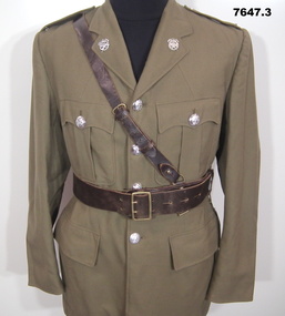
... goldfields 3. Sam Browne Belt issued to "V101972 LT. E. HUMPHREYS" - AR AUSTRALIA 31/8 - 1970. Uniform Army Service dress Sam Browne Belt 1. Manufacturers information on label. Black ink print "E.W. P/LTD/SOUTH ...3. Sam Browne Belt issued to "V101972 LT. E. HUMPHREYS" - AR AUSTRALIA 31/8 - 1970.1. Jacket - Khaki wool/polyester fabric, Service dress style with belt, silver colour plastic buttons with shank and split pin. Buttons have raised emblem - Armoured Corps. Collar, shoulder epaulettes with silver "1AR" Metal insignia badge - 1st Armoured Regiment; four front pockets, top two with buttons and two metal press studs on flap, lower with flap. Two lapel badges, metal, Armoured Corps. Green colour polyester fabric lining with white cotton manufactureres label - inside right. 2. Belt, Khaki colour wool/polyester fabric, with brass colour metal buckle, brown plastic buttons and leather belt keepers. 3. "Sam Browne" belt, consists of waist belt and shoulder strap, brown colour leather with brass buckle, studs and keepers.1. Manufacturers information on label. Black ink print "E.W. P/LTD/SOUTH AUSTRALIA/1966/ ^/SIZE 42 LONG/ CLASS 8505/66-019-8493/ ARMY NO/ NAME/ DRY CLEAN ONLY/ REPRESS USING IRON AND DAMP/ CLOTH OR MEDIUM TO HOT/ STEAM IRON/ CREASE UPPER HALF OF LAPELS/ ONLY" Handwritten blue ink pen "V101972 LT E. HUMPHREYS/ 1-AR AUSTRALIA/ 31/8 - 1970" uniform, army, service dress, sam browne belt -
 Bendigo Military Museum
Uniform - JACKET, SERVICE DRESS, ARMY, Australian Defence Industries, 1965
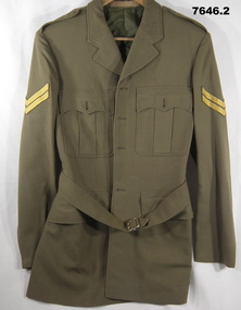
... goldfields Uniform issued to Spr 1. Berry. Reg No. 314007. Uniform Army Service dress Manufacturers information on labels, black ink print. From top to bottom labels; 1. "KENTISH/ SOUTH ...Uniform issued to Spr 1. Berry. Reg No. 314007.1. Jacket, Khaki colour, wool/polyester fabric. Service dress style with belt. No buttons, collar, shoulder epaulettes, four front pockets, top two with button hole and two metal press studs on flap, lower with flaps. Rank insignia on upper sleeve - two stripes, Corporal. Green colour polyester fabric lining with four white cotton manufacturers labels - inside left. 2. Belt, Khaki colour, wool/polyester fabric with gold colour plastic buckle, green plastic buttons and leather belt keepers.Manufacturers information on labels, black ink print. From top to bottom labels; 1. "KENTISH/ SOUTH AUSTRALIA 1965/ ^". 2. "SIZE 39 REGULAR/ CLASS 8405/ 66-019-8464" 3. "REGIMENTAL NO/ NAME" HANDWRITTEN IN BLACK INK "314007/ Spr BERRY" 4. "DRY CLEAN ONLY/ REPRESS USING IRON AND DAMP/ CLOTH OR MEDIUM TO HOT/ STEAM IRON/ CREASE UPPER HALF OF LAPELS/ ONLY" Handwritten in black ink pen "BERRY I.".uniform, army, service dress -
 Bendigo Military Museum
Photograph - Visit by the Chief of the General Staff to the Army Survey Regiment, Fortuna, Bendigo, 1979
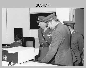
... goldfields This is a set of 14 photographs of a visit to the Army Survey Regiment, Fortuna, Bendigo on the 5th of June 1979 by the Chief of the General Staff (CGS) Lieutenant General Sir Donald Dunstan AC, KBE, CB. He was accompanied by his wife. They were escorted through the production areas of the Army Survey Regiment by the CO LTCOL Bob Skitch. Lieutenant General Sir Donald Dunstan AC, KBE, CB was an esteemed Australian Army officer, who was CGS from 1977 to 1982. Upon retirement from the Army in 1982, he was appointed to the position of Governor of South ...This is a set of 14 photographs of a visit to the Army Survey Regiment, Fortuna, Bendigo on the 5th of June 1979 by the Chief of the General Staff (CGS) Lieutenant General Sir Donald Dunstan AC, KBE, CB. He was accompanied by his wife. They were escorted through the production areas of the Army Survey Regiment by the CO LTCOL Bob Skitch. Lieutenant General Sir Donald Dunstan AC, KBE, CB was an esteemed Australian Army officer, who was CGS from 1977 to 1982. Upon retirement from the Army in 1982, he was appointed to the position of Governor of South Australia from 1982 to 1991. LTCOL Bob Skitch was the CO of the Army Svy Rgt from 1976 to 1980. Also featuring in these photos is MAJ Peter Eddy, who was the OC of Air Survey Squadron. He was later promoted to LTCOL and was CO of the Army Svy Rgt from 1981 to 1982. See item 6035.9P for photos of the CGS’s presentation of the Defence Force Service Medal to four recipients.This is a set of 14 photographs of a visit by the Chief of the General Staff to the Army Survey Regiment Fortuna, Bendigo on the 5th of June 1979. The photographs were printed on photographic paper and are part of the Army Survey Regiment’s Collection. They were scanned at 300 dpi. .1) - Photo, black and white, 1979. Tour of Air Survey Squadron. L to R: unidentified, LTGEN General Sir Donald Dunstan AC, KBE, CB; OC MAJ Peter Eddy, unidentified. .2) - Photo, black and white, 1979. Tour of Air Survey Squadron. LTGEN General Sir Donald Dunstan AC, KBE, CB; views 3D stereoscopic aerial photography on a Zeiss (Jena) Stecometer. OC MAJ Peter Eddy is on his right. .3) - Photo, black and white, 1979. Tour of Air Survey Squadron. L to R: unidentified, CO LTCOL Bob Skitch, OC MAJ Peter Eddy, LTGEN General Sir Donald Dunstan AC, KBE CB viewing an aerial photograph. WO1 Brian Mead and others are operating a Wild PUG4 point transfer device. .4) - Photo, black and white, 1979. Enlargement of photo .3). Tour of Air Survey Squadron. L to R: unidentified, CO LTCOL Bob Skitch, OC MAJ Peter Eddy, LTGEN General Sir Donald Dunstan AC, KBE CB viewing an aerial photograph. .5) - Photo, black and white, 1979. Tour of Air Survey Squadron. LTGEN General Sir Donald Dunstan AC, KBE, CB; and unidentified technician view 3D stereoscopic aerial photography on a Wild B8 stereo plotter. .6) - Photo, black and white, 1979. Tour of Air Survey Squadron. L to R: OC MAJ Peter Eddy LTGEN General Sir Donald Dunstan AC, KBE CB; CO LTCOL Bob Skitch, view the output of a verification plot on an AUTOMAP 1 Gerber 1442 drum plotter. .7) - Photo, black and white, 1979. Tour of Air Survey Squadron. L to R: CO LTCOL Bob Skitch, unidentified aide de camp officer, LTGEN General Sir Donald Dunstan AC, KBE CB; OC MAJ Peter Eddy discuss aero triangulation planning documents. CAPT Don Maskew in background. .8) - Photo, black and white, 1979. Tour of Cartographic Squadron. L to R: CPL Dennis Learmonth, acting OC CAPT Bob Roche, CAPT Eddy Schulze, LTGEN General Sir Donald Dunstan AC, KBE CB; SSGT John ‘JB’ Barrie discuss cartographic map compilation procedures .9) - Photo, black and white, 1979. Tour of Cartographic Squadron. L to R: Tech WO WO1 Roger Rix, acting OC CAPT Bob Roche, CAPT Eddy Schulze, unidentified visitor, Mrs Dunstan with examples of map products. .10) - Photo, black and white, 1979. Tour of Cartographic Squadron. L to R: CPL Terry Danger, CO LTCOL Bob Skitch, LTGEN General Sir Donald Dunstan AC, KBE CB; discuss terrain embossing (hill shading) procedures. .11) - Photo, black and white, 1979. Tour of Cartographic Squadron. L to R: CO LTCOL Bob Skitch, LTGEN General Sir Donald Dunstan AC, KBE CB; acting OC CAPT Bob Roche, SSGT Dick Manley, CAPT Don Maskew and CAPT Steve Cooper in background. SPR Cheryl Lofthouse is retouching blemishes on a map separation film negative. .12) - Photo, black and white, 1979. Tour of Lithographic Squadron. L to R: CAPT Stan Vote, unidentified aide de camp officer, CO LTCOL Bob Skitch, LTGEN General Sir Donald Dunstan AC, KBE CB; MAJ Sam Schwartz EXCH-US, LT John Harrison discuss bulk map printing processes with an Ultra-MAN-III Printing Press. .13) - Photo, black and white, 1979. Officers Mess L to R: LTGEN General Sir Donald Dunstan AC, KBE CB; with CO LTCOL Bob Skitch. .14) - Photo, black and white, 1979. Officers Mess L to R: MAJ Peter Eddy, LTGEN General Sir Donald Dunstan AC, KBE CB..1P to .14P – no annotationsroyal australian survey corps, rasvy, army survey regiment, army svy regt, fortuna, asr -
 Bendigo Military Museum
Photograph - Army Survey Regiment - Defence Force Service Medal Presentations, Fortuna Villa, Bendigo, 1979
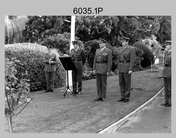
... Bendigo Military Museum 37 - 39 Pall Mall Bendigo goldfields This is a set of nine photographs of Defence Force Service Medal presentations by the Chief of the General Staff (CGS) Lieutenant General Sir Donald Dunstan AC, KBE, CB; at the Army Survey Regiment, Fortuna, Bendigo on the 5th of June 1979. The photos were taken next to the flagpole in Fortuna Villa’s front garden. Upon retirement from the Army in 1982, Lieutenant General Sir Donald Dunstan AC, KBE, CB; was appointed to the position of Governor of South ...This is a set of nine photographs of Defence Force Service Medal presentations by the Chief of the General Staff (CGS) Lieutenant General Sir Donald Dunstan AC, KBE, CB; at the Army Survey Regiment, Fortuna, Bendigo on the 5th of June 1979. The photos were taken next to the flagpole in Fortuna Villa’s front garden. Upon retirement from the Army in 1982, Lieutenant General Sir Donald Dunstan AC, KBE, CB; was appointed to the position of Governor of South Australia from 1982 to 1991. On this occasion the CGS presented the Defence Force Service Medal to WO2 Alex Cairney, WO1 Bob Mason and WO2 Ken Slater for 15 years of efficient remunerated service in the Australian Army. It is likely the unidentified UK Exchange senior NCO was the recipient of the UK Army’s equivalent service medal. Other key staff appearing in these photos are LTCOL Bob Skitch was the CO of the Army Svy Rgt from 1976 to 1980 and WO1 Aub Harvey, who was RSM from 1976 to 1982. MAJ Don Swiney MBE was later promoted to LTCOL and was CO of the Army Svy Rgt from 1985 to 1987. He was subsequently promoted to Colonel and was Director of the Royal Australian Survey Corp from November 1988 to January 1991, and the honorary position as Colonel Commandant from January 1993 to January 1996. See item 6034.14P for photos of the CGS’s tour through the production areas of the Army Svy Rgt.This is a set of nine photographs of Defence Force Service Medal presentations by the Chief of the General Staff (CGS) at the Army Survey Regiment, Fortuna, Bendigo on the 5th of June 1979. The photographs were printed on photographic paper and are part of the Army Survey Regiment’s Collection. They were scanned at 300 dpi. .1) - Photo, black and white, 1979. L to R: RSM WO1 Aub Harvey, CAPT Don Maskew, CGS LTGEN General Sir Donald Dunstan AC, KBE, CB; MAJ Don Swiney MBE, CO LTCOL Bob Skitch. .2) - Photo, black and white, 1979. Foreground L to R: CO LTCOL Bob Skitch, MAJ Don Swiney MBE, CGS LTGEN General Sir Donald Dunstan AC, KBE, CB; CAPT Don Maskew. Background L to R: WO2 Ken Slater, WO2 Alex Cairney, WO1 Bob Mason, unidentified UK Exchange senior NCO. .3) - Photo, black and white, 1979. L to R: WO2 Ken Slater, WO2 Alex Cairney, WO1 Bob Mason, unidentified UK Exchange senior NCO. .4) & .5) - Photo, black and white, 1979. L to R: WO2 Ken Slater, CGS LTGEN General Sir Donald Dunstan AC, KBE, CB; CAPT Don Maskew, MAJ Don Swiney MBE, CO LTCOL Bob Skitch. .6) - Photo, black and white, 1979. L to R: RSM WO1 Aub Harvey, unidentified UK Exchange senior NCO, , CGS LTGEN General Sir Donald Dunstan AC, KBE, CB; MAJ Don Swiney MBE, CO LTCOL Bob Skitch, unidentified aide de camp officer. .7) - Photo, black and white, 1979. L to R: RSM WO1 Aub Harvey, WO2 Alex Cairney, CAPT Don Maskew, LTGEN General Sir Donald Dunstan AC, KBE, CB; MAJ Don Swiney MBE, CO LTCOL Bob Skitch, unidentified aide de camp officer, unidentified photographer. .8) - Photo, black and white, 1979. L to R: RSM WO1 Aub Harvey, CAPT Don Maskew, WO1 Bob Mason, LTGEN General Sir Donald Dunstan AC, KBE, CB; MAJ Don Swiney MBE, CO LTCOL Bob Skitch, unidentified aide de camp officer, unidentified RAAF officer, MAJ Peter Eddy. .9) - Photo, black and white, 1979. L to R: WO1 Bob Mason, WO2 Ken Slater, RSM WO1 Aub Harvey, WO2 Alex Cairney, unidentified UK Exchange senior NCO..1P to .14P – no annotationsroyal australian survey corps, rasvy, army survey regiment, army svy regt, fortuna, asr -
 Bendigo Military Museum
Uniform - JACKET, SERVICE DRESS, ARMY, Australian Defence Industries, 1971
... Bendigo Military Museum 37 - 39 Pall Mall Bendigo goldfields Uniform Army Service Dress Manufacturers information on label - black ink print. "E.W. P/LTD/ SOUTH ...Jacket, khaki colour, wool/polyester fabric. Service dress style. No belt or buttons. Collar, shoulder epaulettes, four front pockets - top two with buttonhole and two metal press studs on flap, lower with flap. Rank Insignia on top sleeve - crown and stripes for Staff Sergeant. Lining - khaki polyester fabric with manufacturers label inside left. Label white cotton fabric.Manufacturers information on label - black ink print. "E.W. P/LTD/ SOUTH AUSTRALIA/ 1971/ ^/ SIZE 39 SHORT/ CLASS 8405/ 66-019-8482/ ARMY NO./ NAME/.DRY CLEAN ONLY/.REPRESS USING IRON AND DAMP/ CLOTH OR MEDIUM TO HOT/ STEAM IRON/. CREASE UPPER HALF OF/ LAPELS ONLY"uniform, army, service dress -
 Bendigo Military Museum
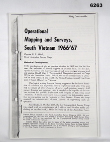
Booklet - Operational Mapping and Surveys - South Vietnam 1966/67, Royal Australian Survey Corps
... goldfields Report written for the "Australian?" Army Journal. This report describes in some detail the Australian 1st Topographical Survey Troop from its initial formation in Oct 1965 through its deployment to South Vietnam in May 1966 and its Operational activities during 1966/67 in support of the 1st Australian Task Force. ...Report written for the "Australian?" Army Journal. This report describes in some detail the Australian 1st Topographical Survey Troop from its initial formation in Oct 1965 through its deployment to South Vietnam in May 1966 and its Operational activities during 1966/67 in support of the 1st Australian Task Force.A4 booklet, stapled in top left corner. "SSgt Learmonth" written on front cover.royal australian survey corps, rasvy, fortuna, army survey regiment, army svy regt, asr, 1st topographical survey troop, south vietnam -
 Bendigo Military Museum
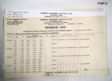
Document - MECHANICAL TEST RESULTS WW2, Thompson's Engineering and Pipe Works, 1942
... goldfields By referring to Cat No 7237.2 will bring up all items associated with Thompsons. Gun Barrel Tests PDR Anti- tank. Signed off by (?) Martin. This is a set of 3 sheets of steel tests on 6 PDR anti-tank gun tests. From Thompsons Engineering & Pipe Co. Lt Castlemaine to General Motors Holden, South ...By referring to Cat No 7237.2 will bring up all items associated with Thompsons.This is a set of 3 sheets of steel tests on 6 PDR anti-tank gun tests. From Thompsons Engineering & Pipe Co. Lt Castlemaine to General Motors Holden, South Aust A/C Ministry of Munitions. 1. Barrel NRS 2483 - 2484 - 2498 - 2499 - Dated 1943. 2. Barrel NRS 1809 - 1812 - 1826 - 1827 - Dated 1942. 3. Barrel NRS 1876 - 1877 - 1859 - 1871 - Dated 1943.Signed off by (?) Martin.gun barrel tests, pdr anti- tank. -
 Bendigo Military Museum
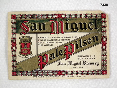
Souvenir - BEER LABEL
... Bendigo Military Museum 37 - 39 Pall Mall Bendigo goldfields San Miguel was a common brand of beer in South East and East Asia, brewed in Manila, Phillipines. ...San Miguel was a common brand of beer in South East and East Asia, brewed in Manila, Phillipines. Item in the collection of Richard William McGILVERY, RAAF. Refer Cat No. 7287P for his service details, photos and awards.Beer bottle label on white paper. Edging on front is pattern of plants in white and red. Trade name of "San Miguel" across top in red and black on gold background and type of beer in same configuration below. Location of brewery in small black writing and brewery emblem. Measure of contents listed below. A number stamped on back.No. “14272 D” stamped on back.bcof, souvenir, beer, richard william mcgilvery -
 Bendigo Military Museum
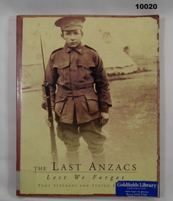
Book - BIOGRAPHY, ANZACS, Tony STEPHENS, "THE LAST ANZACS", 1996
... Goldfields Library/CORPORATION" blue, white, black adhesive label and print on front, spine and back. Soft cover book. Cover - cardboard, yellow and brown colour background. Black, brown and colour print on front, spine and back. Illustrated, front sepia photograph of a young soldier standing with rifle in right hand. 106 pages - cut, plain, white colour gloss paper. Illustrated black/brown and white photographs and maps. "THE LAST ANZACS" Book BIOGRAPHY, ANZACS Tony STEPHENS Steven SIEWERT Fremantle Arts Centre Press South ...Soft cover book. Cover - cardboard, yellow and brown colour background. Black, brown and colour print on front, spine and back. Illustrated, front sepia photograph of a young soldier standing with rifle in right hand. 106 pages - cut, plain, white colour gloss paper. Illustrated black/brown and white photographs and maps."Goldfields Library/CORPORATION" blue, white, black adhesive label and print on front, spine and back.publications, books, military history, biographies, ww1 -
 Bendigo Military Museum
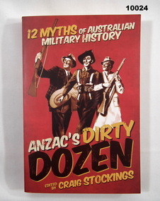
Book - ANTHYOLOGY, MILITARY MYTHS, Craig Stockings, 'ANZAC'S DIRTY DOZEN", 2012
... goldfields From Title Page, "ANZAC'S DIRTY/ DOZEN/ 12 MYTHS OF AUSTRALIAN MILITARY HISTORY" Publications Books Military History Anthology Soft cover book. Cover - cardboard, red colour background with white, yellow and black print on front, spine and back. Illustrated - sepia drawings from Military posters. Front - three persons, two holding rifles, one in uniform. Back - two persons, one in uniform, second holding a rifle. 335 pages - cut, plain, white colour paper. No illustrations. 'ANZAC'S DIRTY DOZEN" Book ANTHYOLOGY, MILITARY MYTHS Craig Stockings New South ...From Title Page, "ANZAC'S DIRTY/ DOZEN/ 12 MYTHS OF AUSTRALIAN MILITARY HISTORY"Soft cover book. Cover - cardboard, red colour background with white, yellow and black print on front, spine and back. Illustrated - sepia drawings from Military posters. Front - three persons, two holding rifles, one in uniform. Back - two persons, one in uniform, second holding a rifle. 335 pages - cut, plain, white colour paper. No illustrations. publications, books, military history, anthology -
 Bendigo Military Museum
Photograph - PHOTOGRAPHIC NEGATIVES & POUCH, V.E. Giudice, 1917
... goldfields On board trip to Europe 1917, WW1 by "Vincent Emelio Giudice". Refer Cat No. 10031P for details. Part of the collection of William (Bill) Thomason. Cat No. 4136P. Vincent Emelio Giudice William (Bill) THOMASON Collection Negatives WW1 Stamped "Specially prepared - referring to 12 pieces. Ref No. 6986 3 1/2 x 2 1/2." Also has instructions for development. 1. Black cellulose negative photo of soldiers on board ship travelling to Europe on a troop convoy. 2. Black cellulose negative photo of boat off the Cape in South ...On board trip to Europe 1917, WW1 by "Vincent Emelio Giudice". Refer Cat No. 10031P for details. Part of the collection of William (Bill) Thomason. Cat No. 4136P.1. Black cellulose negative photo of soldiers on board ship travelling to Europe on a troop convoy. 2. Black cellulose negative photo of boat off the Cape in South Africa. 3. Tattered brown envelope containing the two negatives.Stamped "Specially prepared - referring to 12 pieces. Ref No. 6986 3 1/2 x 2 1/2." Also has instructions for development.vincent emelio giudice, william (bill) thomason collection, negatives, ww1