Showing 30 items matching " loddon creek"
-
 Bendigo Historical Society Inc.
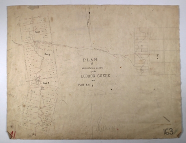
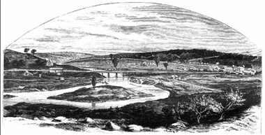
Map - LODDON CREEK, Circa 1860
... LODDON CREEK...... loddon Creek...Map: Plan of agricultural lands upon the Loddon Creek in the parish of Shelbourne...History House 11 Mackenzie Street Bendigo goldfields MAP Bendigo agricultural lands Agricultural Lands loddon Creek Shelbourne Map: Plan of agricultural lands upon the Loddon Creek in the parish of Shelbourne Map LODDON CREEK ...Map: Plan of agricultural lands upon the Loddon Creek in the parish of Shelbournemap, bendigo, agricultural lands, agricultural lands, loddon creek, shelbourne -
 Bendigo Historical Society Inc.
Map - SALISBURY WEST : COUNTY OF BENDIGO, 3-3-1944
... Salisbury, County of Bendigo, County of Gladstone, Powlett, Yarrayne, Bridgewater, Inglewood, River Loddon, Bullabul Creek, Glenalbyn, Kurting. By Authority H.E. ...Salisbury, County of Bendigo, County of Gladstone, Powlett, Yarrayne, Bridgewater, Inglewood, River Loddon, Bullabul Creek, Glenalbyn, Kurting. By Authority H.E. ...Map. Salisbury, County of Bendigo, County of Gladstone, Powlett, Yarrayne, Bridgewater, Inglewood, River Loddon, Bullabul Creek, Glenalbyn, Kurting. By Authority H.E. Daw, Government Printer, Melbourne. Drawn and reproduced at the Department of Lands and Survey, Melbourne., 3-3-1944. Price 5/-. (number 94 in map cupboard 1)H.E. Daw, Government Printer, Melbourne.map, bendigo, salisbury west -
Bendigo Historical Society Inc.
Map - SALISBURY WEST : COUNTY OF BENDIGO, 24-6-24
... Salisbury, County of Bendigo, County of Gladstone, Powlett, Yarrayne, Bridgewater, Inglewood, Glenalbyn, Kurting, River Loddon, Bulabul Creek. By authority A.J. Mullett, Government Printer, Melbourne. ...Salisbury, County of Bendigo, County of Gladstone, Powlett, Yarrayne, Bridgewater, Inglewood, Glenalbyn, Kurting, River Loddon, Bulabul Creek. By authority A.J. Mullett, Government Printer, Melbourne. ...Map. Salisbury, County of Bendigo, County of Gladstone, Powlett, Yarrayne, Bridgewater, Inglewood, Glenalbyn, Kurting, River Loddon, Bulabul Creek. By authority A.J. Mullett, Government Printer, Melbourne. Photo-Lithographed at the Department of Lands and Survey, Melbourne by W.J. Butson, 24-6-24. Price 1/-. (number 116 in map cupboard 1)A.J. Mullett, Government Printer, Melbourne.map, bendigo, salisbury west -
Bendigo Historical Society Inc.
Map - BRIDGEWATER : COUNTY OF BENDIGO, 6-10-27
... Bridgewater, County of Bendigo, Inglewood, Salisbury, Derby, Leichardt, Yarraberb, Yarrayne, Bullock Creek, Loddon River, Sandhurst and Inglewood Railway. ...Bridgewater, County of Bendigo, Inglewood, Salisbury, Derby, Leichardt, Yarraberb, Yarrayne, Bullock Creek, Loddon River, Sandhurst and Inglewood Railway. ...Map. Bridgewater, County of Bendigo, Inglewood, Salisbury, Derby, Leichardt, Yarraberb, Yarrayne, Bullock Creek, Loddon River, Sandhurst and Inglewood Railway. Photo-Lithographed at the Department of Lands and Survey Melbourne by W.J. Butson, 6-10-27. Price 1/-. (number 53 in map cupboard 1)W.J. Butsonmap, bendigo, bridgewater -
Bendigo Historical Society Inc.
Map - JANIEMBER EAST : COUNTY OF BENDIGO, 15-1-34
... Janiember East, County of Bendigo, Jarklan, Pompapiel, Yarrayne, Powlet, Janiember West, Serpentine Creek, Caney's Blind Creek Long Plain Creek, Loddon River. By authority : H.J. Green, Govt. ...Janiember East, County of Bendigo, Jarklan, Pompapiel, Yarrayne, Powlet, Janiember West, Serpentine Creek, Caney's Blind Creek Long Plain Creek, Loddon River. By authority : H.J. Green, Govt. ...Map. Janiember East, County of Bendigo, Jarklan, Pompapiel, Yarrayne, Powlet, Janiember West, Serpentine Creek, Caney's Blind Creek Long Plain Creek, Loddon River. By authority : H.J. Green, Govt. Printer, Melbourne. Drawn and reproduced at the Department of Lands and Survey, Melbourne, Victoria. Price 2/-. 15-1-34. (number 45 in map cupboard 1)H.J. Green, Govt. Printer, Melbourne.map, bendigo, janiember east -
 Ballarat Heritage Services
Photograph - Colour, Vaughan Chinese Cemetery, 2017, 16/07/2017
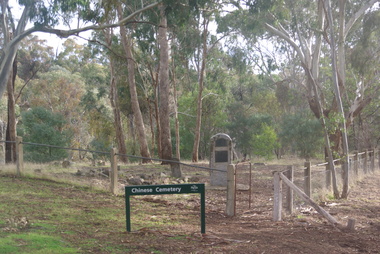
... Established during the great Mount Alexander alluvial gold rush of 1852-54 the cemetery is located on a small hill overlooking one of the richest spots on the goldfield (the junction of Fryers Creek and Loddon River). The location of the cemetery was chosen because it was a convenient piece of ground where gold was not likely to be discovered, and burials were mainly of Chinese miners. ...Ballarat Heritage Services PO Box 2209 Bakery Hill Post Office goldfields Established during the great Mount Alexander alluvial gold rush of 1852-54 the cemetery is located on a small hill overlooking one of the richest spots on the goldfield (the junction of Fryers Creek and Loddon River). The location of the cemetery was chosen because it was a convenient piece of ground where gold was not likely to be discovered, and burials were mainly of Chinese miners. ...Established during the great Mount Alexander alluvial gold rush of 1852-54 the cemetery is located on a small hill overlooking one of the richest spots on the goldfield (the junction of Fryers Creek and Loddon River). The location of the cemetery was chosen because it was a convenient piece of ground where gold was not likely to be discovered, and burials were mainly of Chinese miners. It remained in use until 1857. The cemetery was restored in 1929 using money raised within the Chinese communities of Bendigo and Castlemaine. Colour photograph of the Chinese Cemetery at Vaughan. vaughan, vaughan springs, vaughan chinese cemetery, chinese -
 Eltham District Historical Society Inc
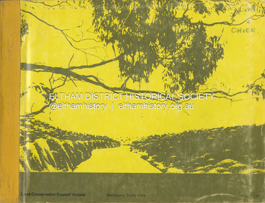
Book, Land Conservation Council, Report on the Melbourne Study Area, December 1973
... It is divided into four main sections: Introduction, Characteristics of environment, main forms of land use and description of 24 specific blocks in the study area which include Torquay, Brisbane Ranges, Werribee, Wombat, Loddon, Romsey, Puckapunyal, Strathbogie, Eildon, Disappointment, Break O'Day, Black Range, Cerberean, Upper Goulburn, Kinglake, Donna Buang, Upper Yarra, Thomson, Dandenongs, Bunyip-Latrobe, Shady Creek, Tyers, Westernport and Strzelecki. ...This report is one of a series describings the physical nature of the land and its environment, examines the likely forms of land use, and assesses the hazards associated with these uses. It is divided into four main sections: Introduction, Characteristics of environment, main forms of land use and description of 24 specific blocks in the study area which include Torquay, Brisbane Ranges, Werribee, Wombat, Loddon, Romsey, Puckapunyal, Strathbogie, Eildon, Disappointment, Break O'Day, Black Range, Cerberean, Upper Goulburn, Kinglake, Donna Buang, Upper Yarra, Thomson, Dandenongs, Bunyip-Latrobe, Shady Creek, Tyers, Westernport and Strzelecki. The Land Conservation Act 1970 established the Land Conservation Council whose functions is to "carry out investigations and make recommendations to the Minister with respect to the use of public land in order to provide for the balanced use of land in Victoria. This report sets out to describe and assess the natural resources of the public lands in the Melbourne area and provides a factual basis on which members of the community may base submissions to the [Land Conservation] Council of Victoria.444 pagesnon-fictionThis report is one of a series describings the physical nature of the land and its environment, examines the likely forms of land use, and assesses the hazards associated with these uses. It is divided into four main sections: Introduction, Characteristics of environment, main forms of land use and description of 24 specific blocks in the study area which include Torquay, Brisbane Ranges, Werribee, Wombat, Loddon, Romsey, Puckapunyal, Strathbogie, Eildon, Disappointment, Break O'Day, Black Range, Cerberean, Upper Goulburn, Kinglake, Donna Buang, Upper Yarra, Thomson, Dandenongs, Bunyip-Latrobe, Shady Creek, Tyers, Westernport and Strzelecki. The Land Conservation Act 1970 established the Land Conservation Council whose functions is to "carry out investigations and make recommendations to the Minister with respect to the use of public land in order to provide for the balanced use of land in Victoria. This report sets out to describe and assess the natural resources of the public lands in the Melbourne area and provides a factual basis on which members of the community may base submissions to the [Land Conservation] Council of Victoria.land use, kinglake, thomson valley, conservation, public lands -
 Bendigo Historical Society Inc.
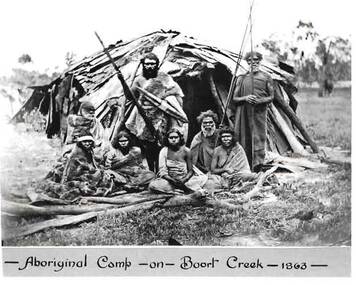
Photograph - HARRY BIGGS COLLECTION: PHOTO OF ABORIGINAL CAMP
... Creek... Prince Charles... Jajoweroung or Loddon Tribe...The Jajoweroung or Loddon Tribe of Blacks. Aboriginal Camp - on Boort Creek, 1863. Names of Aborigines - Left to Right. ...Creek - 1863 -' Photo is inside envelope 2400 418a. On the back of photo 2400 419a the following is hand written in blue ink. The Jajoweroung or Loddon ...Black and white photo of a group of Jajoweroung or Loddon Aboriginal people in front of their camp. The group consists of four women sitting behind some wooden branches and four men all in native dress. Two men are standing holding spears and two are sitting. The male standing to the left is Prince Charlie and standing to the right is Batten. Behind them is a hut made of bark and sticks. On the bottom of the photo is printed in black ink 'Aboriginal Camp - on - Boort Creek - 1863 -' Photo is inside envelope 2400 418a. On the back of photo 2400 419a the following is hand written in blue ink. The Jajoweroung or Loddon Tribe of Blacks. Aboriginal Camp - on Boort Creek, 1863. Names of Aborigines - Left to Right. Women sitting in front row - Lizzie, Caroline, Maryanne, Kitty. The two men sitting behind the women - Adam, Nero. The two men standing back row - Prince Charlie, Batten. Photo is in envelope 2400.418aphoto, group, aboriginal camp boort creek, boort creek, prince charles, jajoweroung or loddon tribe -
 Bendigo Historical Society Inc.
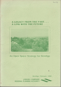
Book - A LEGACY FROM THE PAST.. A LINK WITH THE FUTURE - AN OPEN SPACE STRATEGY FOR BENDIGO, 1988
... Loddon-Campaspe Regional Planning Authority, February 1988. Illustrated with maps, B&W photos and sketches. Main chapters 1. Open Space and Bendigo 2. An Open Space System - water courses and Bendigo Creek...Loddon-Campaspe Regional Planning Authority, February 1988. Illustrated with maps, B&W photos and sketches. Main chapters 1. Open Space and Bendigo 2. An Open Space System - water courses and Bendigo Creek ...32 page soft cover booklet 'A Legacy from the Past… a Link with the Future. An Open Space Strategy for Bendigo' Prepared for the Bendigo Sub-Regional Committee of the Loddon-Campaspe Regional Planning Authority, February 1988. Illustrated with maps, B&W photos and sketches. Main chapters 1. Open Space and Bendigo 2. An Open Space System - water courses and Bendigo Creek 3. The Provision of Public Open Space 4. Study Conclusions and Proposals.Evan Jonesregional planning authority, open space, bendigo council -
Bendigo Historical Society Inc.
Map - TARNAGULLA : COUNTY OF BENDIGO, 13-5-22
... County of Bendigo, County of Gladstone.Inglewood, Glenalbyn, Kingower, Moliagul, Waanyarra, Laaneoorie, Woodstock, Loddon River, Township of Tarnagulla, Township of Newbridge, Township of Llanelly, Dunolly to Inglewood Railway, Tarnagulla Rifle Range, Laurie Station, Bullabul Creek, Arnold Township, Arnold Railway Station. ...County of Bendigo, County of Gladstone.Inglewood, Glenalbyn, Kingower, Moliagul, Waanyarra, Laaneoorie, Woodstock, Loddon River, Township of Tarnagulla, Township of Newbridge, Township of Llanelly, Dunolly to Inglewood Railway, Tarnagulla Rifle Range, Laurie Station, Bullabul Creek, Arnold Township, Arnold Railway Station. ...Map. County of Bendigo, County of Gladstone.Inglewood, Glenalbyn, Kingower, Moliagul, Waanyarra, Laaneoorie, Woodstock, Loddon River, Township of Tarnagulla, Township of Newbridge, Township of Llanelly, Dunolly to Inglewood Railway, Tarnagulla Rifle Range, Laurie Station, Bullabul Creek, Arnold Township, Arnold Railway Station. Photo-Lithographed at the Department of Lands and Survey, Melbourne by W.J. Butson, 13-5-22.Price 1/-.By authority A.J. Mullett, Government Printer, Melbourne. (number 118 in map cupboard 1)A.J. Mullett, Government Printer, Melbourne.map, bendigo, tarnagulla -
Bendigo Historical Society Inc.
Map - TARNAGULLA : COUNTY OF BENDIGO, 1959
... Tarnagulla, County of Bendigo, County of Gladstone, Inglewood, Glenalbyn, Kingower, Moliagul, Painswick, Waanyarra, Laanecoorie, Woodstock, Derby, Loddon River, Dunolly to Inglewood Railway, Laurie Railway Station, Township of Tarnagulla, Tarnagulla Rifle Range, Township of Llanelly, Arnold Railway Station, Bullabul Creek, Kangderaar Creek, Township of Newbridge. ...Tarnagulla, County of Bendigo, County of Gladstone, Inglewood, Glenalbyn, Kingower, Moliagul, Painswick, Waanyarra, Laanecoorie, Woodstock, Derby, Loddon River, Dunolly to Inglewood Railway, Laurie Railway Station, Township of Tarnagulla, Tarnagulla Rifle Range, Township of Llanelly, Arnold Railway Station, Bullabul Creek, Kangderaar Creek, Township of Newbridge. ...Map. Tarnagulla, County of Bendigo, County of Gladstone, Inglewood, Glenalbyn, Kingower, Moliagul, Painswick, Waanyarra, Laanecoorie, Woodstock, Derby, Loddon River, Dunolly to Inglewood Railway, Laurie Railway Station, Township of Tarnagulla, Tarnagulla Rifle Range, Township of Llanelly, Arnold Railway Station, Bullabul Creek, Kangderaar Creek, Township of Newbridge. By authority A.C. Brooks, Government Printer, Melbourne. Drawn and reproduced at the Department of Lands and Survey, Melbourne, 1959. (number 117 in map cupboard 1)A.C. Brooks, Government Printer, Melbourne.map, bendigo, tarnagulla -
 Bendigo Historical Society Inc.
Document - EXTRACT FROM THE BENDIGO INDEPENDENT APRIL 16 1887: MYERS FAMILY/MYERS CREEK, 16th April, 1887
... Reference to Mr Campbell, Bullock Creek Hotel and Station; Mr John Catto (Loddon homestead); Mouat Bros (Yarraberb Station) M'Intyre (squatter of Kangaroo Flat and Big Hill) ; Buzza's Paddock (Myers' Flat). ...Reference to Mr Campbell, Bullock Creek Hotel and Station; Mr John Catto (Loddon homestead); Mouat Bros (Yarraberb Station) M'Intyre (squatter of Kangaroo Flat and Big Hill) ; Buzza's Paddock (Myers' Flat). ...Extract from the Bendigo Independent April 16 1887 re Myers Family/Myers Creek. Titled The local dawn of civilization - A Pre-auriferous pioneer. Settlement by William and Thomas Myers. Story of settlement of area told by first wife of William Myers (Mrs Hayward). Recollection of Mrs Hayward's re the naming of Bendigo ( ('bendy-go'). Reference to Mr Campbell, Bullock Creek Hotel and Station; Mr John Catto (Loddon homestead); Mouat Bros (Yarraberb Station) M'Intyre (squatter of Kangaroo Flat and Big Hill) ; Buzza's Paddock (Myers' Flat). Mention of Superintendent Gilbert and Dr Backhaus.Bendigo Independentperson, individual, myers family, myers flat police station, buzz's paddock, bullock creek hotel and station, port phillip, myers creek. -
 Bendigo Historical Society Inc.
Document - CONNELLY, TATCHELL, DUNLOP COLLECTION: LEGAL PAPERS, 1889 - 11895
... Loddon. Re costs. 8 - 1910 - McNamara John, Mosquito Creek. Costs re Foy. 9 - 1895 - Letter to The Officer in Charge of Police, Raywood - Albert C Dungey? ...Loddon. Re costs. 8 - 1910 - McNamara John, Mosquito Creek. Costs re Foy. 9 - 1895 - Letter to The Officer in Charge of Police, Raywood - Albert C Dungey? ...Document. Connelly, Tatchell & Dunlop. Legal papers. 1 - 1892 - Wishart D, Macorna. Re costs. 2 - 1892 - McKoene, deceased. Notes concerning. 3 - 1892 - Echuca Shire. Re costs. 4 - 1891 - Pierce & Perry. Re costs. 5 - 1891 - Hopkinson, deceased. Re costs. 6 - Irrigable Estates to Prior. Re costs. 7 - 1889 - 1891 - Shire of East Loddon. Re costs. 8 - 1910 - McNamara John, Mosquito Creek. Costs re Foy. 9 - 1895 - Letter to The Officer in Charge of Police, Raywood - Albert C Dungey? (? Const. 4008). Mentions G H Lezard. 10 - 1890 - Letter dated 15 Jul 1890 signed S?T?M? (surname unreadable - (?ath). 11 - 1894 - Letter dated 20 April 1894 written by Fordyce? Joseph acting for liquidator.cottage, miners, connelly, tatchell & dunlop, wishart d, mckoene, echuca shire, pierce & perry, hopkinson, irrigable estates, prior, shire of east loddon, mcnamara john, foy, officer in charge of police raywood, dungey? a c, lezard g h, fordyce jos., prior m a mrs -
 Federation University Historical Collection
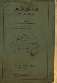
Book, Stanley B. Hunter, Memoirs of the Geological Survey of Victoria No 7., The Deep Leads of Victoria, 1909
... loddon system...clunes...creswick...spring hill...bullarook...castlemaine - daylesford...majorca...carisbrook...timor...burnt creek...Contents include tunnelling, deep sinking, the Chiltern Method, the Ballarat Method, Stawell, Ararat, Moyston, Raglan, Wimmera, Landsborough, Avoca, Ballarat West Leads, Berry-Moolort-Loddon Lead System, Clunes, Creswick, Bullarook Affluent, Corinella, Daylesford-Castlemaine Tributary, Majorca-Carisbrook tributary, Huntly, Coliban, Campaspe, Rutherglen., Smythesdale, Durham Lead, Tanjil, Evolution of Mining Machinery, size of claims, Definition of a Deep Lead, Discovery of Gold in Victoria, Geographical Position of Deep Leads, Water in Deep Leads, Methods of Deep Lead Mining, Cost of Deep Lead Mining, Stawell, Ararat, Moyston, Raglan, Wimmera, Landsborough, Avoca, Ballarat West, Berry, Springs Hill, Loddon Valley, Charlotte Plains, , Timor, Burn Creek, Huntly, Colinan, Goulburn, Ovens Valley, Chiltern, Indigo, Morrison's Lead, Plans include: geological Map of Stawell, ararat, Raglan and Landsborough; Kempson's Freehold Mine, Stawell; Geological Map of Beaufort, Avoca, Maryborough, Ballarat west, Berry-Moolort, Loddon, Creswick, Marong, &c; Cardigan Propriety Gold Mine; Working Miners United Gold Mine, Homebush; Hepburn Deep Lead Plan; Madame Berry West Mine; West Berry Consols Mine; Spring Hill and Central Leads; Berry Consols Extended Mine; Loddon Valley Goldfields; Chalk's No 3 Mine; Charlotte Plains Considated Mine; Duke United Mine; Geological Map of Bendigo, Huntley, Campaspe, Malmsbury, Kyneton, trentham, &c; Geological Map of Chiltern, Rutherglan, Eldorado, Beechworth, &c; Chiltern Valley Gold Mine; Wallace Chiltern Valley Consols Mine; great Southern and Chiltern Valley United Mine; great Northern extended Consols; Prentice and Southern deep Leads; Glenfine South Gold Mine; Geological map of Pitfield, Rokewood, Mt Mercer, Ballark, Meredith, &c.; McEvoy Mine; Dargo . . . . . . . . . . . . . . . . . . . . . . . ...Barker Library (top floor) Mount Helen goldfields mining deep leads squire tools gold panning gold cradle cradling puddling tubbing mining shaft shaft sinking whip horse whip whim horse whim chalk's no. 1 mine, maryborough mining cage shaft mining trucks maryborough washdirt puddler tunnelling deep sinking chiltern method of working ballarat method of working sampling washdirt. gravels balmoral mt william stawell moyston great western ararat raglan wimmera valley landsborough cardigan haddon beaufort waterloo avoca lamplough caralulup ballarat west ballarat smythesdale glenfine illabarook durham lead morrison's lead bullengarook berry-moolort-loddon system clunes creswick spring hill bullarook castlemaine - daylesford majorca carisbrook timor burnt creek tributary tarnagulla marong rheola inglewood huntly coliban campaspe goulburn lead system ovens valley system mitta mitta kiewa valley tarago tanjil moondarra bogong dargo high plains Pink paper covered book by Stanley Hunter, Engineer in Charge of Boring Operations. ...Pink paper covered book by Stanley Hunter, Engineer in Charge of Boring Operations. Contents include tunnelling, deep sinking, the Chiltern Method, the Ballarat Method, Stawell, Ararat, Moyston, Raglan, Wimmera, Landsborough, Avoca, Ballarat West Leads, Berry-Moolort-Loddon Lead System, Clunes, Creswick, Bullarook Affluent, Corinella, Daylesford-Castlemaine Tributary, Majorca-Carisbrook tributary, Huntly, Coliban, Campaspe, Rutherglen., Smythesdale, Durham Lead, Tanjil, Evolution of Mining Machinery, size of claims, Definition of a Deep Lead, Discovery of Gold in Victoria, Geographical Position of Deep Leads, Water in Deep Leads, Methods of Deep Lead Mining, Cost of Deep Lead Mining, Stawell, Ararat, Moyston, Raglan, Wimmera, Landsborough, Avoca, Ballarat West, Berry, Springs Hill, Loddon Valley, Charlotte Plains, , Timor, Burn Creek, Huntly, Colinan, Goulburn, Ovens Valley, Chiltern, Indigo, Morrison's Lead, Plans include: geological Map of Stawell, ararat, Raglan and Landsborough; Kempson's Freehold Mine, Stawell; Geological Map of Beaufort, Avoca, Maryborough, Ballarat west, Berry-Moolort, Loddon, Creswick, Marong, &c; Cardigan Propriety Gold Mine; Working Miners United Gold Mine, Homebush; Hepburn Deep Lead Plan; Madame Berry West Mine; West Berry Consols Mine; Spring Hill and Central Leads; Berry Consols Extended Mine; Loddon Valley Goldfields; Chalk's No 3 Mine; Charlotte Plains Considated Mine; Duke United Mine; Geological Map of Bendigo, Huntley, Campaspe, Malmsbury, Kyneton, trentham, &c; Geological Map of Chiltern, Rutherglan, Eldorado, Beechworth, &c; Chiltern Valley Gold Mine; Wallace Chiltern Valley Consols Mine; great Southern and Chiltern Valley United Mine; great Northern extended Consols; Prentice and Southern deep Leads; Glenfine South Gold Mine; Geological map of Pitfield, Rokewood, Mt Mercer, Ballark, Meredith, &c.; McEvoy Mine; Dargo . . . . . . . . . . . . . . . . . . . . . . . mining, deep leads, squire, tools, gold panning, gold cradle, cradling, puddling, tubbing, mining shaft, shaft sinking, whip, horse whip, whim, horse whim, chalk's no. 1 mine, maryborough, mining cage, shaft, mining trucks, maryborough, washdirt, puddler, tunnelling, deep sinking, chiltern method of working, ballarat method of working, sampling washdirt. gravels, balmoral, mt william, stawell, moyston, great western, ararat, raglan, wimmera valley, landsborough, cardigan, haddon, beaufort, waterloo, avoca, lamplough, caralulup, ballarat west, ballarat, smythesdale, glenfine, illabarook, durham lead, morrison's lead, bullengarook, berry-moolort-loddon system, clunes, creswick, spring hill, bullarook, castlemaine - daylesford, majorca, carisbrook, timor, burnt creek tributary, tarnagulla, marong, rheola, inglewood, huntly, coliban, campaspe, goulburn lead system, ovens valley system, mitta mitta, kiewa valley, tarago, tanjil, moondarra, bogong, dargo high plains -
 Federation University Historical Collection
Book, Mines Department, Victoria, Deep Leads of Victoria, 1937, 1937
... loddon system...clunes...creswick...spring hill...bullarook...castlemaine - daylesford...majorca...carisbrook...timor...burnt creek...Contents include Ballarat, berry Consols, Canadian Lead, Castlemaine-Daylesford System, Chiltern, Duke of Cornwall Mine, Dyke's Freehold, Frenchman's Lead, Garibaldi Shaft, Glenfine, Guidlford, Hepburn Estate Co., Hepburn Home Paddock, Italian Gully, Henderson's Lead, Langi Logan, Leigh Consols, Sebastopol Plateau; Talbot, Woady Yalloak, A definition of a deep lead, formation of deep leads, water in deep leads, methods of deep lead mining (Tunnelling, Deep sinking, Chiltern method of working, Ballarat method of working), sampling washdirt and gravels, Balmoral, Mt William, Stawell, Moyston, Great Western, Ararat, Raglan, Wimmera Valley, Landsborough, Cardigan, Haddon, Beaufort, Waterloo, Avoca, Lamplough, Caralulup, Ballarat West, Ballarat, Smythesdale, Glenfine, Illabarook, Durham Lead, Morrison's Lead, Bullengarook, Berry-Moolort-Loddon System, Clunes, Creswick, Spring Hill, Bullarook, Castlemaine - Daylesford, Majorca, Carisbrook, Timor, Burnt Creek Tributary, Tarnagulla, Marong, Rheola, Inglewood, Huntly, Coliban, Campaspe, Goulburn Lead System, Ovens Valley System, Mitta Mitts, Kiewa Valley, Tarago, Tanjil, Moondarra, Bogong, Dargo High Plains, glossary...Barker Library (top floor) Mount Helen goldfields mining deep leads mines department squire leigh consols chiltern duke of cornwall mine dyke's freehold frenchman's lead garibaldi shaft glenfine guidlford hepburn estate co. hepburn home paddock italian gully henderson's lead langi logan sebastopol plateau talbot woady yalloak tunnelling deep sinking chiltern method of working ballarat method of working sampling washdirt. gravels balmoral mt william stawell moyston great western ararat raglan wimmera valley landsborough cardigan haddon beaufort waterloo avoca lamplough caralulup ballarat west ballarat smythesdale illabarook durham lead morrison's lead bullengarook berry-moolort-loddon system clunes creswick spring hill bullarook castlemaine - daylesford majorca carisbrook timor burnt creek tributary tarnagulla marong rheola inglewood huntly coliban campaspe goulburn lead system ovens valley system mitta mitta kiewa valley tarago tanjil moondarra bogong dargo high plains Charcoal green soft covered book of 64 pages. ...Charcoal green soft covered book of 64 pages. Contents include Ballarat, berry Consols, Canadian Lead, Castlemaine-Daylesford System, Chiltern, Duke of Cornwall Mine, Dyke's Freehold, Frenchman's Lead, Garibaldi Shaft, Glenfine, Guidlford, Hepburn Estate Co., Hepburn Home Paddock, Italian Gully, Henderson's Lead, Langi Logan, Leigh Consols, Sebastopol Plateau; Talbot, Woady Yalloak, A definition of a deep lead, formation of deep leads, water in deep leads, methods of deep lead mining (Tunnelling, Deep sinking, Chiltern method of working, Ballarat method of working), sampling washdirt and gravels, Balmoral, Mt William, Stawell, Moyston, Great Western, Ararat, Raglan, Wimmera Valley, Landsborough, Cardigan, Haddon, Beaufort, Waterloo, Avoca, Lamplough, Caralulup, Ballarat West, Ballarat, Smythesdale, Glenfine, Illabarook, Durham Lead, Morrison's Lead, Bullengarook, Berry-Moolort-Loddon System, Clunes, Creswick, Spring Hill, Bullarook, Castlemaine - Daylesford, Majorca, Carisbrook, Timor, Burnt Creek Tributary, Tarnagulla, Marong, Rheola, Inglewood, Huntly, Coliban, Campaspe, Goulburn Lead System, Ovens Valley System, Mitta Mitts, Kiewa Valley, Tarago, Tanjil, Moondarra, Bogong, Dargo High Plains, glossarymining, deep leads, mines department, squire, leigh consols, chiltern, duke of cornwall mine, dyke's freehold, frenchman's lead, garibaldi shaft, glenfine, guidlford, hepburn estate co., hepburn home paddock, italian gully, henderson's lead, langi logan, sebastopol plateau, talbot, woady yalloak, tunnelling, deep sinking, chiltern method of working, ballarat method of working, sampling washdirt. gravels, balmoral, mt william, stawell, moyston, great western, ararat, raglan, wimmera valley, landsborough, cardigan, haddon, beaufort, waterloo, avoca, lamplough, caralulup, ballarat west, ballarat, smythesdale, illabarook, durham lead, morrison's lead, bullengarook, berry-moolort-loddon system, clunes, creswick, spring hill, bullarook, castlemaine - daylesford, majorca, carisbrook, timor, burnt creek tributary, tarnagulla, marong, rheola, inglewood, huntly, coliban, campaspe, goulburn lead system, ovens valley system, mitta mitta, kiewa valley, tarago, tanjil, moondarra, bogong, dargo high plains -
Federation University Historical Collection
Book, Historic Sites Survey: North Central Study Area, 1979, 1979
... loddon united waterworks trust...gouldburn weir...carisbrook lock-up...history of tree planting in streets...history of public reserves...r.u. nicholls nurseryman...thomas lang...francis moss...ballarat botanical gardens...ballarat school of mines botanical gardens...lake wendouree...victoria park, ballarat...muont holled smith...ballaarat old cemetery planting...eastern oval...ballarat east botanical gardens...ballarat east town hall gardens...eureka stockade reserve...ballarat observatory plantings...yarrowee creek...Barker Library (top floor) Mount Helen goldfields The North Central Study Area included the Shires of Avoca, Bet Bet, east Loddon, Goulburn, Untly, Kara Kara, Korong, Maldon, Marong, Metcalfe, McIvor, Newstead, Strathfieldsaye, Stawell, Talbot, Clunes, Tullaroop and Waranga. castlemaine mount alexander goldfield maldon percydale warrenmang moliagul tarnagulla stuart mill the whipstick whroo rushworth graytown ironbark forest st arnoaud new bendigo landsborough inglewood kurting wedderburn wehla kooroora langham flat mcintyre rheola diamond hill fosterville coliban water works green gully newstead muckleford forest costerfield graytown bailieston waranga irrigaiton system eucalyptus distillery mia mia bridge korokubeal township researce concegella slate quarry chewton fryerstown kingower timor talbot majorca carisbroook clunes st arnaud taradale icomos dunolly limestone castlemaine slate quarry harcourt granite taradale railway viaduct loddon united waterworks trust gouldburn weir carisbrook lock-up history of tree planting in streets history of public reserves r.u. nicholls nurseryman thomas lang francis moss ballarat botanical gardens ballarat school of mines botanical gardens lake wendouree victoria park, ballarat muont holled smith ballaarat old cemetery planting eastern oval ballarat east botanical gardens ballarat east town hall gardens eureka stockade reserve ballarat observatory plantings yarrowee creek plantings yarrowee bluestone channels ballarat woollen mill band and albion mullock heap black hill plantings yarrowee creek channels canadian creek channel specimen vale channel poverty point reserve union jack reserve buninyong imperial mine, buninyong victoria street plantings bridge mall sturt street gardens ballarat avenue of honour plantings white flat oval plantings camp street elms burnt creek 153 page book with white plastic binding. ...The North Central Study Area included the Shires of Avoca, Bet Bet, east Loddon, Goulburn, Untly, Kara Kara, Korong, Maldon, Marong, Metcalfe, McIvor, Newstead, Strathfieldsaye, Stawell, Talbot, Clunes, Tullaroop and Waranga. 153 page book with white plastic binding. It is an historic sites survey for the North Central Study Area commissioned by the Land Conservation Council, the Ministry for COnservation and the Australian Heritage Commission. castlemaine, mount alexander goldfield, maldon, percydale, warrenmang, moliagul, tarnagulla, stuart mill, the whipstick, whroo, rushworth, graytown ironbark forest, st arnoaud, new bendigo, landsborough, inglewood, kurting, wedderburn, wehla, kooroora, langham flat, mcintyre, rheola, diamond hill, fosterville, coliban water works, green gully, newstead, muckleford forest, costerfield, graytown, bailieston, waranga irrigaiton system, eucalyptus distillery, mia mia bridge, korokubeal township researce, concegella slate quarry, chewton, fryerstown, kingower, timor, talbot, majorca, carisbroook, clunes, st arnaud, taradale, icomos, dunolly, limestone, castlemaine slate quarry, harcourt granite, taradale railway viaduct, loddon united waterworks trust, gouldburn weir, carisbrook lock-up, history of tree planting in streets, history of public reserves, r.u. nicholls nurseryman, thomas lang, francis moss, ballarat botanical gardens, ballarat school of mines botanical gardens, lake wendouree, victoria park, ballarat, muont holled smith, ballaarat old cemetery planting, eastern oval, ballarat east botanical gardens, ballarat east town hall gardens, eureka stockade reserve, ballarat observatory plantings, yarrowee creek plantings, yarrowee bluestone channels, ballarat woollen mill, band and albion mullock heap, black hill plantings, yarrowee creek channels, canadian creek channel, specimen vale channel, poverty point reserve, union jack reserve buninyong, imperial mine, buninyong, victoria street plantings, bridge mall, sturt street gardens, ballarat avenue of honour plantings, white flat oval plantings, camp street, elms, burnt creek -
Whitehorse Historical Society Inc.
Map, Yarra River, n.d
... Whitehorse Historical Society Inc. 2-10 Deep Creek Road Mitcham melbourne aveling grace nutt t.h. yarra river Copy of fold-out map 'Loddon 25' included in 'Lilydale', by Grace Aveling. ...Copy of fold-out map 'Loddon 25' included in 'Lilydale', by Grace Aveling. Based on T.H. Nutt's original survey of the Yarra River, 1839.aveling, grace, nutt, t.h., yarra river -
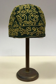 Kew Historical Society Inc
Headwear - Green Cotton & Yellow Silk Ribbon Smoker's or Lounge Cap, 1860s
... Intriguingly the entry in the Gazetteer claims that the electoral division of Vaughan began at the junction of the Middleton Creek and the Loddon River, so perhaps the cap might have belonged to a member of a significant local family. ...Intriguingly the entry in the Gazetteer claims that the electoral division of Vaughan began at the junction of the Middleton Creek and the Loddon River, so perhaps the cap might have belonged to a member of a significant local family. ...The context in which the hat was made and worn assists in establishing its potential historic significance. 'Bailliere's Victorian Gazetteer and Road Guide containing the most recent and accurate information as to every place in the Colony' (1870), describes the village of Vaughan as being located on the road from Daylesford to Castlemaine. In 1870 the Vaughan was deemed to be entirely a gold mining area, gold having been discovered in the district in 1853. Intriguingly the entry in the Gazetteer claims that the electoral division of Vaughan began at the junction of the Middleton Creek and the Loddon River, so perhaps the cap might have belonged to a member of a significant local family. In 1870, Vaughan had a population of about 1000 persons and included almost 300 dwellings. Articles from newspapers, published on Trove refer frequently to a Mr Middleton as a litigant in court cases before the Vaughan Court in the 1860s. By the 1870s, the Mt Alexander Mail, in an article on ‘Mining: The Pioneer Wheel’ describes the success of Mr Middleton and his Middleton’s Reef Gold Quartz Mining Company, which had built the largest water wheel in the Colony. The wheel was 20’ in diameter and 2’ wide. Quartz mining as practiced by companies such as Middleton’s had become necessary after the exhaustion of alluvial quartz mining deposits in the 1860s. So we can probably establish a link between the cap and a significant mining identity in the period in which the article was made. The historical significance of the cap is only one part of the story. Caps such as the Middleton example can also be items of aesthetic significance as they were typically, examples of women’s work, using published patterns in magazines such as the Ladies Home Magazine. While women might follow or adapt a published pattern, their choice of materials reflected what was available locally. The fine hand stitching on this example is evidence of high quality domestic needlework. The maker crafted the cap from five triangular pieces of cotton cloth, each piece lined with a faded yellow net. The net provides some stiffening for the cap and has a functional purpose in that it anchors the hand-stitched, looped design of yellow silk ribbon that decorates the surface of the cap. Gentleman’s smoking (lounging) cap believed to have been made in c.1860-69. The conical hat is made of a dark green cotton fabric embroidered with narrow ribbon of a paler green silk. The unlined rimless hat is made of four pieces of fabric. There is no evidence of the hat at one stage featuring a tassle. The original donation record noted that the cap had been made for, and was worn by, a Mr Middleton, of Vaughan in Central Victoria. Nilhats, smokers hats, men's clothing -
 Ballarat Heritage Services
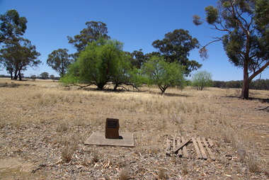
Photograph - School site, Site of the former Kurting State School, 2016, 10/01/2016
... Creek State School in 1893 and then in 1928 became the Powlett State School. The school burnt down in 1944 with school being held in the hall until the end of 1945. In 1946, the children of the area were bused to Inglewood. [Kurting - 808, Kurting - 2026 and Kurting - 2353] kurting kurting state school kurting primary school Site of Kurting State School N0. 2026 1878 - 1947 Project of Loddon Shire Council 2-4-2000 A plaque indicating the site of the Kurting Primary School. ...The Kurting State School No 2353 opened in 1881. The name changed to Hope Creek State School in 1893 and then in 1928 became the Powlett State School. The school burnt down in 1944 with school being held in the hall until the end of 1945. In 1946, the children of the area were bused to Inglewood. [Kurting - 808, Kurting - 2026 and Kurting - 2353]A plaque indicating the site of the Kurting Primary School. Site of Kurting State School N0. 2026 1878 - 1947 Project of Loddon Shire Council 2-4-2000kurting, kurting state school, kurting primary school -
 Ballarat Heritage Services
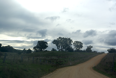
Photograph - Photograph - Colour, Clare Gervasoni, Tarilta, 2017, 16/07/2017
... It was originally Kangaroo Flat, being located where the Kangaroo Creek enters the Loddon River. It was surveyed and named in 1864. ...It was originally Kangaroo Flat, being located where the Kangaroo Creek enters the Loddon River. It was surveyed and named in 1864. ...Tarilta is a rural locality and former gold-mining town 12 km south of Castlemaine, 4 km north-west of Guildford and 3 km north-east of Vaughan. The last gold mining activity took place around the 1880s. It was originally Kangaroo Flat, being located where the Kangaroo Creek enters the Loddon River. It was surveyed and named in 1864. Gold was discovered at Tarilta in 1853. The Tarilta School was opened in 1860 in a Wesleyan chapel, and closed i n1925. In 1864 a township was surveyed and named Tarilta, the word being derived from an Aboriginal expression thought to mean kangaroo. In 1865 Bailliere’s Victorian gazetteer described Tarilta as being an alluvial and quartz gold-mining town with three quartz-crushing mills, three horse-puddling machines and two hotels. The elevated nature of the land around Tarilta made it accessible only by horse and dray, or on horseback. Colour photograph of Tarilta in Central Victoria. tarilta, central victoria, landcape -
 Ballarat Heritage Services
Photograph - Image, Guildford, Victoria, 1867
... GUILDFORD Is a small township situated at the junction of Campbell's Creek and the Loddon. It is about seven miles from Castlemaine, on the road from that town to Ballaarat and Daylesford. ...Ballarat Heritage Services PO Box 2209 Bakery Hill Post Office goldfields guildford loddon river GUILDFORD Is a small township situated at the junction of Campbell's Creek and the Loddon. ...Black and white image of Guildford, near Castlemaine, VictoriaGUILDFORD Is a small township situated at the junction of Campbell's Creek and the Loddon. It is about seven miles from Castlemaine, on the road from that town to Ballaarat and Daylesford. The land near the Loddon is very rich, and as a large number both of theoretical and practical miners believe that a rich goldfield underlies the surface basalt, there is every probability of Guildford being ere an important goldfield. A large area of land in the neighbourhood has been already worked, principaIy by Chinamen, who until very recently mustered in great force in the locality. (Illustrated Adelaide Post, 23 March 1867)guildford, loddon river -
Tarnagulla History Archive
Photocopies: Historical Tarnagulla letters, 1859-1874
... Two page letter from John Papineau of Sandy Creek to the Surveyor General regarding gazetting of land for a racecourse 3 miles from Newbridge next to the Loddon, and further gazetting to protect cemetery area at Tarnagulla from gold miners. ...Two page letter from John Papineau of Sandy Creek to the Surveyor General regarding gazetting of land for a racecourse 3 miles from Newbridge next to the Loddon, and further gazetting to protect cemetery area at Tarnagulla from gold miners. ...Murray Comrie Collection. Photocopies of seven historical handwritten letters associated with Tarnagulla. Original letters are all 19th Century. Whereabouts of originals unknown. Copies probably made by Murray Comrie in the 1960s. 1. Character reference for David Renshaw written by Thomson & Comrie (1874?) - 1 copy 2. Letter to Melbourne Postmaster from William ______ about an advertisement (1860) - 3 copies 3. Two page letter from John Papineau of Sandy Creek to the Surveyor General regarding gazetting of land for a racecourse 3 miles from Newbridge next to the Loddon, and further gazetting to protect cemetery area at Tarnagulla from gold miners. (August 1859) Original may be in Lands Dept - 2 copies 4. Letter from the Postmaster Sandy Creek to same at Melbourne regarding daily mail despatch times (March 1860) - 3 copies 5. Letter to the Mayor and Councillors of the Borough of Tarnagulla from Prince Alfred? thanking them for welcoming him during his visit (1867). Original may be in Hall. - 3 copies 6. Letter to the Dept of Lands and Survey, Melbourne from John Papineau of Sandy Creek. States that he has enclosed a copy of his August 2nd letter. (1859) - 4 copies 7. Letter to David Renshaw from Parliament House. Appears to be a character reference. Dated 3rd October 1874 - 2 copies of page 1 only, no second page. tarnagulla, residents, renshaw, papineau, post office, newbridge, racecourse, cemetery, thomson, comrie -
Tarnagulla History Archive
News clipping: Our Loddon Valley Aborigines - The Jajowrongs, Our Loddon Valley Aborigines - The Jajowrongs, June 23, 1981
... Tarnagulla History Archive Tarnagulla Public Hall 69-71 Commercial Rd Tarnagulla goldfields Murray Comrie Collection. central victoria dja dja wurrung djadjawurrung indigenous australians indigenous history traditional owners names naming maryborough area bet bet creek birthing tree talbot rock wells A double page article from The Advertiser (Maryborough) newspaper of June 23, 1981 with article about the Indigenous traditional owners of the region, the Djadjawurung and sites of cultural significance . Our Loddon ...Murray Comrie Collection. A double page article from The Advertiser (Maryborough) newspaper of June 23, 1981 with article about the Indigenous traditional owners of the region, the Djadjawurung and sites of cultural significance . central victoria, dja dja wurrung, djadjawurrung, indigenous australians, indigenous history, traditional owners, names, naming, maryborough area, bet bet creek, birthing tree talbot, rock wells -
Tarnagulla History Archive
Registration of Birth form, 1871
... Creek/Tarnagulla Post and Telegraph Office in the later 20th Century, during building works. Donald Clark Collection. Registration of Birth form for: Child's name: William Alfred Hiatt Date of Birth: 25th September 1871 Place of birth: Waanyarrra Loddon Father: George Edward Hiatt Mother: Nesa (nee Bennett) Registration of Birth form ...A large lot of papers, including this and many other birth and death registration forms, were apparently found in the ceiling cavity of the Sandy Creek/Tarnagulla Post and Telegraph Office in the later 20th Century, during building works. Donald Clark Collection. Registration of Birth form for: Child's name: William Alfred Hiatt Date of Birth: 25th September 1871 Place of birth: Waanyarrra Loddon Father: George Edward Hiatt Mother: Nesa (nee Bennett) -
Tarnagulla History Archive
Registration of Birth form, 1871
... Creek/Tarnagulla Post and Telegraph Office in the later 20th Century, during building works. Donald Clark Collection. Registration of Birth form for: Child's name: John Fyfe Date of Birth: 28th January 1872 Place of birth: Newbridge Loddon Marong Shire Father: James Fyfe Mother: Mary Agnes (nee Naughton) Registration of Birth form ...A large lot of papers, including this and many other birth and death registration forms, were apparently found in the ceiling cavity of the Sandy Creek/Tarnagulla Post and Telegraph Office in the later 20th Century, during building works. Donald Clark Collection. Registration of Birth form for: Child's name: John Fyfe Date of Birth: 28th January 1872 Place of birth: Newbridge Loddon Marong Shire Father: James Fyfe Mother: Mary Agnes (nee Naughton) -
Tarnagulla History Archive
Registration of Birth form, 1872
... Creek/Tarnagulla Post and Telegraph Office in the later 20th Century, during building works. Donald Clark Collection. Registration of Birth form for: Child's name: Julia Margaret Frank Date of Birth: 27th March, 1872 Place of birth: Loddon Bet Bet Shire Father: John Frank Mother: Margaret Frank (nee Derby) Registration of Birth form ...A large lot of papers, including this and many other birth and death registration forms, were apparently found in the ceiling cavity of the Sandy Creek/Tarnagulla Post and Telegraph Office in the later 20th Century, during building works. Donald Clark Collection. Registration of Birth form for: Child's name: Julia Margaret Frank Date of Birth: 27th March, 1872 Place of birth: Loddon Bet Bet Shire Father: John Frank Mother: Margaret Frank (nee Derby) -
Tarnagulla History Archive
Registration of Birth form, 1871
... Creek/Tarnagulla Post and Telegraph Office in the later 20th Century, during building works. Donald Clark Collection. Registration of Birth form for: Child's name: Emma B. Bool Date of Birth: 23rd July, 1871 Place of birth: Loddon ...A large lot of papers, including this and many other birth and death registration forms, were apparently found in the ceiling cavity of the Sandy Creek/Tarnagulla Post and Telegraph Office in the later 20th Century, during building works. Donald Clark Collection. Registration of Birth form for: Child's name: Emma B. Bool Date of Birth: 23rd July, 1871 Place of birth: Loddon B.B. (Bet Bet) Father: Frederick Bool Mother: Elizabeth Ellen Bool (nee Hockey) -
Tarnagulla History Archive
Registration of Birth form, 1872
... Creek/Tarnagulla Post and Telegraph Office in the later 20th Century, during building works. Donald Clark Collection. Registration of Birth form for: Child's name: Walter Henry Classon Date of Birth: 8th March, 1872 Place of birth: Newbridge Loddon Father: John August Classon Mother: Elizabeth (Maiden name: section damaged 'Was____') Registration of Birth form ...A large lot of papers, including this and many other birth and death registration forms, were apparently found in the ceiling cavity of the Sandy Creek/Tarnagulla Post and Telegraph Office in the later 20th Century, during building works. Donald Clark Collection. Registration of Birth form for: Child's name: Walter Henry Classon Date of Birth: 8th March, 1872 Place of birth: Newbridge Loddon Father: John August Classon Mother: Elizabeth (Maiden name: section damaged 'Was____') -
Tarnagulla History Archive
Registration of Birth form, 1870s
... Creek/Tarnagulla Post and Telegraph Office in the later 20th Century, during building works. Donald Clark Collection. Registration of Birth form for: Child's name: Frederick Surrey Erwin Date of Birth: 4th October, 1871 Place of birth: Loddon Newbridge Father: Henry Erwin Mother: Julia Erwin (nee Baldwin) Registration of Birth form ...A large lot of papers, including this and many other birth and death registration forms, were apparently found in the ceiling cavity of the Sandy Creek/Tarnagulla Post and Telegraph Office in the later 20th Century, during building works. Donald Clark Collection. Registration of Birth form for: Child's name: Frederick Surrey Erwin Date of Birth: 4th October, 1871 Place of birth: Loddon Newbridge Father: Henry Erwin Mother: Julia Erwin (nee Baldwin) -
 Bendigo Historical Society Inc.
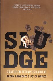
Book - "Sludge. Disaster on Victoria's Goldfields", 2019
... Sludge submerged Victoria's grapevines near Bendigo, filled Laanecoorie Reservoir on the Loddon River and flowed down from Beechworth over thousands of hectares of rich agricultural land. Children and animals drowned in sludge lakes. The mining effluent contaminated three-quarters of Victoria's creeks and rivers. ...Sludge submerged Victoria's grapevines near Bendigo, filled Laanecoorie Reservoir on the Loddon River and flowed down from Beechworth over thousands of hectares of rich agricultural land. Children and animals drowned in sludge lakes. The mining effluent contaminated three-quarters of Victoria's creeks and rivers. ...Gold made Victoria rich, but that came with disastrous results for the land - engulfing it in flood of sand, gravel and silt that gushed out of mines. This environmental devastation still affects the rivers and flood plains. Victorians had a name for this mining waste - 'Sludge'. Sludge submerged Victoria's grapevines near Bendigo, filled Laanecoorie Reservoir on the Loddon River and flowed down from Beechworth over thousands of hectares of rich agricultural land. Children and animals drowned in sludge lakes. The mining effluent contaminated three-quarters of Victoria's creeks and rivers. "Sludge. Disaster on Victoria's Goldfields" by Susan Lawrence and Peter Davies. Published by La Trobe University Press in conjunction with Black Inc. in 2019. Soft cover. Front cover is gold in color with title and author's names in black and white with small image of two gold prospectors. Back cover and spine also gold in color. 307 pp. Printed by McPherson's Printing Group. Contains both text and black and white images. ISBN 9781760641108. gold, mining waste, sludge, mining