Showing 1777 items matching " map document"
-
 Victorian Aboriginal Corporation for Languages
Book, Ian D Clark, Place names and land tenure : windows into Aboriginal landscapes : essays in Victorian Aboriginal history, 1998
... maps, document reproductions...Victorian Aboriginal Corporation for Languages 33 Saxon Street Brunswick melbourne Djab Wurrung Ngengen Wurrung Koroitgundidj Dhauwurud Wurrung Djab Wurrung Barababaraba Daung Wurrung Taungurung Dja Dja Wurrung Jardwadjali Jodajoda Yorta Yorta Nguri-illam Wurrung Waywurru Koroit Buangor Mt Eccles Mt Napier Langi Ghiran Grampians National Park massacres clan organization land tenure George Augustus Robinson Samuel Carter Aldo Massola Alfred William Howitt maps, document reproductions This work is a collection of twelve essays that are concerned with place names, clan organisation and local and regional Aboriginal history. ...This work is a collection of twelve essays that are concerned with place names, clan organisation and local and regional Aboriginal history.maps, document reproductionsdjab wurrung, ngengen wurrung, koroitgundidj, dhauwurud wurrung, djab wurrung, barababaraba, daung wurrung, taungurung, dja dja wurrung, jardwadjali, jodajoda, yorta yorta, nguri-illam wurrung, waywurru, koroit, buangor, mt eccles, mt napier, langi ghiran, grampians national park, massacres, clan organization, land tenure, george augustus robinson, samuel carter, aldo massola, alfred william howitt -
 Victorian Aboriginal Corporation for Languages
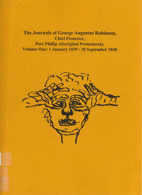
Book, Ian D Clark, The journals of George Augustus Robinson, Chief Protector, Port Phillip Aboriginal Protectorate : volume one : 1 January 1839 - 30 September 1840, 1998
... maps, document reproductions, b&w illustrations, word lists...Victorian Aboriginal Corporation for Languages 33 Saxon Street Brunswick melbourne George Augustus Robinson Port Phillip colonisation maps, document reproductions, b&w illustrations, word lists Transcription of G. ...Transcription of G. A. Robinson?s journals for the period 01/01/1839 - 30/09/1840. Includes some reproductions of sketches, and some wordlists of Aboriginal languages and Aboriginal personal and place names.maps, document reproductions, b&w illustrations, word listsgeorge augustus robinson, port phillip, colonisation -
 Victorian Aboriginal Corporation for Languages
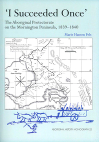
Book, Marie Hansen Fels, I succeeded once : the Aboriginal Protectorate on the Mornington Peninsula, 1839-1840, 2011
... maps, document reproductions, b&w illustrations, colour illustrations, colour photographs...Victorian Aboriginal Corporation for Languages 33 Saxon Street Brunswick melbourne Boon wurrung Yarra Mission William Thomas maps, document reproductions, b&w illustrations, colour illustrations, colour photographs 1. ...1. The writings of William Thomas 2. The Context 3. The record of observation 4. Tubberubbabel, Protectorate head station 5. Kangerong, Protectorate second station 6. Buckkermitterwarrer, Protectorate third station 7. Kullurk, the Bonurong choice for a reserve 8. The raid into Gippsland and the massacres remembered 9. Manufacturing industry on the Mornington Peninsula, 'the successful plan at Arthurs Seat' 10. Death of Johnny and his burial on the foreshore at McCrae 11. The abduction between Arthurs Seat and Point Nepean, and Yankee Yankee's return 12. Thomas' translations.maps, document reproductions, b&w illustrations, colour illustrations, colour photographsboon wurrung, yarra mission, william thomas -
 Victorian Aboriginal Corporation for Languages
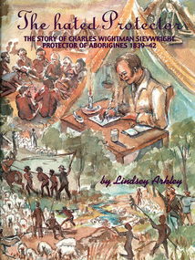
Book, Lindsey Arkley, The hated protector : the story of Charles Wightman Sievwright, protector of Aborigines 1839-42, 2000
... maps, document reproductions, b&w photographs, colour photographs, b&w illustrations...Victorian Aboriginal Corporation for Languages 33 Saxon Street Brunswick melbourne Charles Wightman Sievwright racial policies British colonial history race relations Victorian history maps, document reproductions, b&w photographs, colour photographs, b&w illustrations "The hated Protector" tells for the first time the real story behind the extraordinary experiences of Charles Sievwright, Assistant Aboriginal Protector from 1839-42 in what was then part of the British colony of New South Wales, but is now the Western District of the Australian state of Victoria. ..."The hated Protector" tells for the first time the real story behind the extraordinary experiences of Charles Sievwright, Assistant Aboriginal Protector from 1839-42 in what was then part of the British colony of New South Wales, but is now the Western District of the Australian state of Victoria. Sievwright, an Edinburgh-born former British army officer, lived in the bush with his young family as he tried to save the Aborigines of the District from extinction. In doing so, he would isolate himself from the rest of his fellow whites. The hated Protector tells of this process. The book should appeal to anyone interested in British colonial and Australian history, particularly in the years of first contact between British settlers and the Aborigines. More broadly, it should also appeal to anyone interested a story of one man's battle against overwhelming odds, where the price of failure was numerous deaths. It is a story of hatred, prejudice, courage, determination, and hope. In telling Sievwright's story, Lindsey Arkley draws largely on original archival material, including official reports, journals and letters, found in Melbourne, Sydney, Hobart, Edinburgh and London. Most has never before been published. The archival material is supplemented by contemporary newspaper accounts, and some oral history. Full notes are given to all sources, and the book is indexed and lavishly illustrated with drawings by Joan Bognuda, as well as about 80 paintings and samples of documents. Contents: 1. In the bush 2. "Equal and indiscriminate justice" 3. "A few doses of lead" 4. "A curse to the land" 5. "The most unpopular man" 6. Retaliation 7. A hostage debate 8. Hallucinations 9. A mass escape 10. Possessors of the soil 11. Move to Keilambete 12. Bureaucratic 13. "A hideous pandemonium" 14. Divine visitations 15. Pay backs 16. Explanations 17. A squatter on trial 18. Claptrap and deceit 19. The black cap - 20. To Mt Rouse 21. "The impending evil" 22. In the balance 23. An arrest at Mt Rouse 24. A fair moral name 25. Roger's trial 16. Intensified evidence 27. A declaration of war 28. Mr Cold Morning 29. Holding ranks 30. To rags 31. Fightback 32. Return to London 33. The inquiry 34. Judgement 35. And what remains.maps, document reproductions, b&w photographs, colour photographs, b&w illustrationscharles wightman sievwright, racial policies, british colonial history, race relations, victorian history -
 Victorian Aboriginal Corporation for Languages
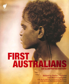
Book, Rachel Perkins, First Australians : an illustrated history, 2008
... maps, document reproductions, b&w illustrations, colour illustrations, colour photographs, b&w photographs...Victorian Aboriginal Corporation for Languages 33 Saxon Street Brunswick melbourne colonisation race relations Australian Aboriginal history pictorial histories maps, document reproductions, b&w illustrations, colour illustrations, colour photographs, b&w photographs "A landmark history of Indigenous Australia which accompanies a major nine part Australian television series. ..."A landmark history of Indigenous Australia which accompanies a major nine part Australian television series. It combines the most rigorous academic research with capitvating contemporary story-telling. Richly illustrated book that includes images of the landscape, evocative ninteenth-century photography and Aboriginal art. Written by Australia's leading Indigenous historian and public intellectuals"--Provided by publisher.maps, document reproductions, b&w illustrations, colour illustrations, colour photographs, b&w photographscolonisation, race relations, australian aboriginal history, pictorial histories -
 Sunshine and District Historical Society Incorporated
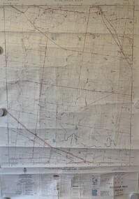
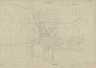
Map - Sydenham West Topographic Map, Vicmap, 1977
... ... Map Document...Sydenham West Topographic Club Topographic Map Document Sydenham West 7822-4-2 Zone 55 1:25000 1977 Topographic Map Printed topographic map of the Sydenham West region Map Sydenham West Topographic Map Vicmap ...Sydenham West 7822-4-2 Zone 55 1:25000 1977 Topographic Mapsydenham west topographic club, topographic, map document -
 Warrnambool and District Historical Society Inc.
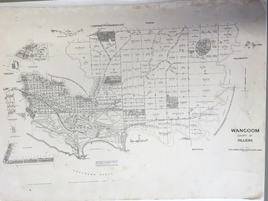
Document: Map, Map Wangoom County of Villiers, 1955
... Document: Map...There are scuff and dirt marks on the map but it is otherwise in good condition. Map Wangoom County of Villiers Document: Map ...This map contains the names, acreage details and dates of the original property owners of the Parish of Wangoom (County of Villiers), excluding the township of Warrnambool. It also has details of the Crown Lands adjoining the Merri and Hopkins Rivers. This is a most important map as it has details on the original property owners. It is a most valuable research tool and is one of our most-used maps.This is a map, printed in black and white and mounted on cardboard. Where there was intensive land ownership the details have been reproduced in larger print on the margins of the map. There are scuff and dirt marks on the map but it is otherwise in good condition.‘Wangoom, County of Villiers’wangoom, warrnambool, county of villiers -
 Victorian Aboriginal Corporation for Languages
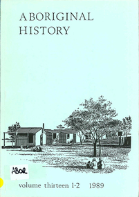
Periodical, Australian National University Department of Pacific and Southeast Asian History, Aboriginal history, 1989
... b&w photographs, maps, charts, document reproductions...Victorian Aboriginal Corporation for Languages 33 Saxon Street Brunswick melbourne b&w photographs, maps, charts, document reproductions Aboriginal history Periodical Australian National University Department of Pacific and Southeast Asian History ...b&w photographs, maps, charts, document reproductions -
 Peterborough History Group
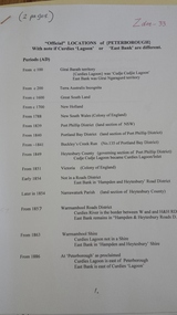
Document - Names of town and locations
... Photocopied pages, map, typed documents...Peterborough History Group Peterborough great-ocean-road copy of gazetting of the town, history of names within the district, history of the street names in Peterborough Photocopied pages, map, typed documents Document Names of town and locations ...copy of gazetting of the town, history of names within the district, history of the street names in PeterboroughPhotocopied pages, map, typed documents -
 Federation University Historical Collection
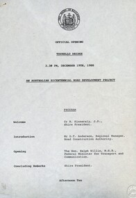
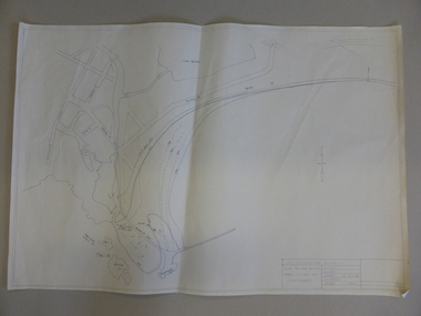
Document - Documents, Tourello: Opening of Tourello Bridge; Tourello Hunt Club, 1909; Tourello Tennis Club; Government Land Auction, 1855
... Maps and typed documents...Anderson Ralph Willis Creswick Maps and typed documents Tourello: Opening of Tourello Bridge; Tourello Hunt Club, 1909; Tourello Tennis Club; Government Land Auction, 1855 Document Documents ...Maps and typed documentstourello bridge, hunt club, tennis club, government land auctions, talbot, clunes, coghill, lenaghan, peter lalor, r. kinnersly, d.t. anderson, ralph willis, creswick -
 Clunes Museum
Document - FOLDER
... FOLDER OF OLD SHIRE MAPS AND DOCUMENTS TALBOT AND CLUNES SHIRE, ETC, ETC....Clunes Museum 36 Fraser Street enter building through Collins Place Clunes goldfields LOCAL HISTORY FOLDER SHIRE OF TALBOT AND CLUNES FOLDER OF OLD SHIRE MAPS AND DOCUMENTS TALBOT AND CLUNES SHIRE, ETC, ETC. ...FOLDER OF OLD SHIRE MAPS AND DOCUMENTS TALBOT AND CLUNES SHIRE, ETC, ETC.local history, folder, shire of talbot and clunes -
Croydon Conservation Society Inc.
Archive, Garden Suburb Estate, Croydon - Archive Collection - Parent Record
... Archive records; maps, plans, documents relating to Garden Suburb Estate, Croydon...Archive records; maps, plans, documents relating to Garden Suburb Estate, Croydon Garden Suburb Estate, Croydon - Archive Collection - Parent Record Archive ...Archive records; maps, plans, documents relating to Garden Suburb Estate, Croydon -
 Bendigo Historical Society Inc.
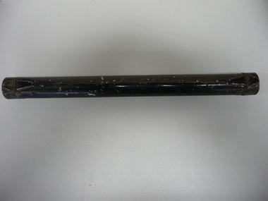
Accessory - METAL CYLINDER
... Metal cylinder for storing map or documents with hinged lid on both ends, painted black....History House 11 Mackenzie Street Bendigo goldfields DOMESTIC EQUIPMENT Containers document Metal cylinder for storing map or documents with hinged lid on both ends, painted black. ...Metal cylinder for storing map or documents with hinged lid on both ends, painted black.domestic equipment, containers, document -
 Warrnambool and District Historical Society Inc.
Document - Map, Soil conservation authority:plan of high water marks at Lady Bay Warrnambool, 1984
... This map documents the changing state of Lady Bay from around 1870 until 1976. ...Warrnambool and District Historical Society Inc. 2 Gilles Street (south of Merri St) Warrnambool great-ocean-road This map documents the changing state of Lady Bay from around 1870 until 1976. ...This map documents the changing state of Lady Bay from around 1870 until 1976. It depicts the changing high water mark over that period and the main outlet of the Merri River in 1872 and 1976.This map provides a useful and significant insight into the ever changing face of Lady Bay from the 1870’s through to 1980’s. Cream paper map drawn with black ink showing Lady Bay and South Warrnambool section of Warrnambool. In lower RH corner Soil conservation AuthorityPlan of High water marks at Lady Bay Warrnambool. Drawn P.D. 19.1/84. Scale 1:3600. Written on back in black pencil: Lady Bay Historical HWM lady bay map, merri river 1872- 1976, merri river 1872- 1976, history of warrnambool -
 Bendigo Military Museum
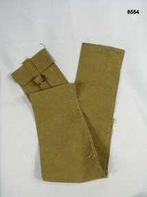
Equipment - CARRY BAG, Unknown
... Long narrow khaki holdall carry bag, most likely used to carry maps or documents....TUPPER Long narrow khaki holdall carry bag, most likely used to carry maps or documents. Equipment CARRY BAG ...Long narrow khaki holdall carry bag, most likely used to carry maps or documents.N. TUPPERpasschendaele barracks trust, holdall, carry bag -
 Melbourne Tram Museum
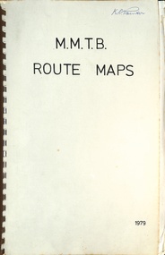
Map, Melbourne & Metropolitan Tramways Board (MMTB), MMTB Route Maps, 1979
... Book - brown comb binding, card and clear plastic covers containing both bound and unbound maps and documents....Book - brown comb binding, card and clear plastic covers containing both bound and unbound maps and documents. MMTB Route Maps Map Melbourne & Metropolitan Tramways Board (MMTB) ...Series of colour maps for various tram and bus routes, dated 1979. Also contained, not scanned are letters, reports, and specifications for printing these maps for use in shelters etc. Some have the Transport Information Centre telephone printed on them. Some are finished with a plastic laminate finish on either one or both sides. Show the major cross streets, parks, schools, other tram routes, major stop numbers, and railway lines. See also item 3909 for another example of these. Trams 1 - City route guide - R9/77 - showing all route numbers and destinations that passed through the CBD. 2 - Bourke St tram routes - R4/77 - East Brunswick Blyth St and East Preston Tyler St and intermediate routes, routes 95, 96, 97, 90, 89 and 88. 3 - Malvern, East Malvern, Carnegie, and East Brighton Tram Routes (from St Kilda Junction) - R1/79 - shows routes 5, 3, 67, 66, 61, 62, and 64. 4 - Elizabeth St tram routes - R12/77 - Essendon Airport, West Maribyrnong, North Coburg lines, routes 50, 58, 60, 54, 57, 52. 49, 59, 18, 20 and 19 5 - Flinders St tram routes - R5/78 - North Balwyn, East Burwood, routes 48, 40, 41, Hartwell, 28, 74 and 75 6 - Kew - St Kilda Beach - R1/79 - Route 69. 7 - Mont - Albert City - R11/77, shows routes 43. 47. 45. 44 8 - St Kilda Rd Tram Routes R12/77 - details South Melbourne Beach, route 1 and route 2 and St Kilda Beach routes 15, 16, and 55 otherwise shows where the various routes branch off St Kilda Road 9 - Batman Ave tram routes - R9/77 - Wattle Park, North Richmond and Prahran - routes 70, 71, 78 and 79. 10 - Footscray - Moonee Ponds - R3/81 - Route 82 11 - Swanston St tram guide - R1/79 - lists all routes and route numbers that branch or cross Swanston St between Grattan St and St Kilda Junction. 12 - Toorak Camberwell and Glen Iris tram route with Camberwell Junction and Malvern Town Hall, R1/79, routes 8, 7, 6, 72, and 73 shown. 13 - West Preston - Beach tram routes - R12/77 - routes 10, 11, 9 and 12, 14 - William St tram routes - R12/77 - Route 55, 56, and 63 - South Melbourne Depot and Domain. Buses 1 - Footscray, Sunshine, Deer Park, Nth Altona & Fishermans Bend - R2/79 2 - Box Hill bus routes to Templestowe, Heidelberg & East Kew - R6/78 - notes superseded by R3/82 3 - Plan of Russell St Melbourne bus departure bays. 4 - Box Hill, Mitcham & Ringwood bus routes to East Doncaster & Warrandyte - R3/82 5 - City - Warrandyte & East Doncaster bus routes - R3/82 & R6/78 6 - Bulleen - City - Port Melbourne - Garden City Bus route - R6/78 7 - North Altona - City bus route - 11/78 8 - Clifton Hill - Elsternwick - R2/79 9 - La Trobe - Northland - West Heidelberg - City Bus Service via East Freeway - 11/79 and R3/81 10 - Box Hill, Mitcham & Ringwood Bus Routes to East Doncaster & Warrandyte - R10/84 - with the Metropolitan Transit logo.Yields information about tram and bus routes in late 1970s early 1980s.Book - brown comb binding, card and clear plastic covers containing both bound and unbound maps and documents.K C Painter on front cover in ink.tramways, mmtb, tram routes, maps, bus routes, route numbers, routes, route guide -
Camberwell Historical Society
Document (Item), Gwen McWilliam, Along the High Street, again, 1994
... A4 document containing maps...Camberwell Historical Society 25 Inglesby Road Camberwell melbourne Camberwell Melbourne High Street A4 document containing maps Along the High Street, again Document Document Gwen McWilliam ...camberwell, melbourne, high street -
 Bendigo Military Museum
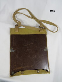
Equipment - FIELD CASE, MAP, Unknown
... Maps or documents are held in place by adjustable slide over clips. ...Bendigo Military Museum 37 - 39 Pall Mall Bendigo goldfields Passchendaele Barracks Trust Field case Maps and documents Khaki over the shoulder field case for maps or documents. ...Khaki over the shoulder field case for maps or documents. The backing base is covered in cotton khaki material with bottom press stud closure buttons. Maps or documents are held in place by adjustable slide over clips. On the inside of the cover there are six sewn in narrow pockets for pens, pencils and relevant recording items.passchendaele barracks trust, field case, maps and documents -
 Peterborough History Group
Document - Principles and Methods of History, Principles and Methods of History, Aboriginal Clans and Language
... Printed A4 document, photocopied maps...Aboriginal clan information baradh clan girai wurrung peterborough 3270 Printed A4 document, photocopied maps Principles and Methods of History, Aboriginal Clans and Language Document Principles and Methods of History ...Academic description of Ken Clements' approach to research. Aboriginal clan informationPrinted A4 document, photocopied mapsbaradh clan, girai wurrung, peterborough 3270 -
Croydon Conservation Society Inc.
Archive, Wicklow Hills Estate Croydon - Archive Collection - Parent Record
... Archive records, documents, maps relating to Wicklow Hills Estate, Croydon...Archive records, documents, maps relating to Wicklow Hills Estate, Croydon Wicklow Hills Estate Croydon - Archive Collection - Parent Record Archive ...Archive records, documents, maps relating to Wicklow Hills Estate, Croydon -
 Wycheproof & District Historical Society Inc.
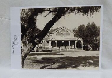
Photograph, Wycheproof Court House, (estimated); mid to late 19th century
... It is now a 'Place of Deposit' for paper based products, maps, documents and photographs, and the home of the Wycheproof and District Historical Society Inc. ...It is now a 'Place of Deposit' for paper based products, maps, documents and photographs, and the home of the Wycheproof and District Historical Society Inc. ...The Court House opened as a court of petty sessions in 1890 and closed as a court in the early 1980s. It is now a 'Place of Deposit' for paper based products, maps, documents and photographs, and the home of the Wycheproof and District Historical Society Inc. The local Craft Group met at the Court House between 1982 and 2010. The Buloke Shire Council oversees the maintenance of the building.The Court House is No H 1656 on the Victorian Heritage Register. It is the one of only two buildings with this listing in Wycheproof, and characteristic of the type of building constructed in the early days of settlement in Wycheproof. The architecture is of aesthetic value and although some restoration work has taken place to maintain the structure, it remains in good condition and with some of the original furnishings intact.Sepia print of the Wycheproof-Court-House. It was constructed during 1889/90 and commissioned on September 23,1890 as a court-of-petty-sessions. A simple form of Court House built of red-face-brick but embellished by stepped brick work in the principal gable and by the traverse veranda with elaborate frieze and gabled pavilions that protect the street facade. The roof is of slate.Nonecourt house, wycheproof heritage 1890, petty sessions, building, red face brick, gabled pavilions -
 Bacchus Marsh & District Historical Society
Map, Plan of Survey of Part of Crown Allotment 9, Parish of Korkuperrimul, 1890
... This map documents a transfer of an allotment of land in Clarke Street Bacchus Marsh in 1890. ...Bacchus Marsh & District Historical Society Lerderderg Library Main Street Bacchus Marsh This map documents a transfer of an allotment of land in Clarke Street Bacchus Marsh in 1890. ...This map documents a transfer of an allotment of land in Clarke Street Bacchus Marsh in 1890. Clarke Street is located on the eastern side of Bacchus Marsh not far from Main Street and Crook Street. It is now known as Candeloro Street. The map indicates J. Booth as the owner of the land and H. Simpson as the occupier. Next to this allotment is a an allotment of land owned by J. Elmore,Single page map showing Crown allotment 9, Parish of Korkuperrimul, County of Bourke. Scale 100 feet to inch. Part of a set of maps which are pasted into a bound volume containing 76 maps or plans in total. High resolution digital image stored on BMDHS computer network. At bottom of map: I hereby certify that I have made this survey expressly for the purpose of an application under the Transfer of Land Statute that this plan is correct. Barry B???, Lic. Surveyor, 16.10.90bacchus marsh victoria maps, clarke street bacchus marsh maps -
 Wodonga & District Historical Society Inc
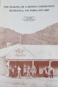
Book - The Making of a Mining Community: Bethanga, Victoria 1875 - 1885
... It consists of 94 pages including images, maps and document extracts....It consists of 94 pages including images, maps and document extracts. The Making of a Mining Community: Bethanga, Victoria 1875 - 1885 Book The Making of a Mining Community: Bethanga, Victoria 1875 - 1885 ...A publication by La Trobe University to support the teaching of V.C.E History Unit 1: Local History. It is presented as 6 investigations focused on aspects of community through a case study of the Upper Bethanga district in Northeast Victoria from 1875 to 1885.A publication by La Trobe University to support the teaching of V.C.E History Unit 1: Local History. It consists of 94 pages including images, maps and document extracts.A publication by La Trobe University to support the teaching of V.C.E History Unit 1: Local History. It is presented as 6 investigations focused on aspects of community through a case study of the Upper Bethanga district in Northeast Victoria from 1875 to 1885.local history, vce resources, bethanga community, bethanga history -
 Bendigo Historical Society Inc.
Document - ALBERT RICHARDSON COLLECTION: NEW CHUM RAILWAY MINE, GOLDEN SQUARE
... Three-page typed document plus map. Document details location and history of the New Chum Railway Mine, Golden Square and includes: depth of shaft, size of lease, locality, poppet legs, winding engine, engine houses, crushing battery, best gold obtained, prominence, and total gold production and dividends. ...History House 11 Mackenzie Street Bendigo goldfields BENDIGO Mining new chum railway gold mine Three-page typed document plus map. Document details location and history of the New Chum Railway Mine, Golden Square and includes: depth of shaft, size of lease, locality, poppet legs, winding engine, engine houses, crushing battery, best gold obtained, prominence, and total gold production and dividends. ...Three-page typed document plus map. Document details location and history of the New Chum Railway Mine, Golden Square and includes: depth of shaft, size of lease, locality, poppet legs, winding engine, engine houses, crushing battery, best gold obtained, prominence, and total gold production and dividends. References provided. Document forms part of research referred to in Albert Richardson's paper 2264.70.bendigo, mining, new chum railway gold mine -
 Ballarat Tramway Museum
Map - Ballarat, State Electricity Commission of Victoria - Electricity Supply Department, Map of Ballarat, 1930s
... Produced by the SEC as a map template for documenting the Ballarat Tramway System....Produced by the SEC as a map template for documenting the Ballarat Tramway System. ...Produced by the SEC as a map template for documenting the Ballarat Tramway System.Print of a drawing showing in very good detail, a map of Ballarat. Was used as a template by the SEC to document items such as tramway and bus routes.SEC template map; "Ballarat". Drawn 1930s. Original dyeline print.Original dyeline print.provincial tramways, state electricity commission of victoria, map, ballarat, ballarat tramways -
 Greensborough Historical Society
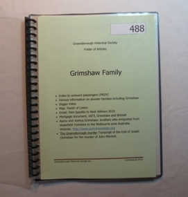
Folder, Grimshaw Family, 1849o
... Passenger indexes; maps; mortgage document 1873 Grimshaw and Britnell; history of Aaron and Joshua Grimshaw; Greensborough murder: transcript of the trial of Josiah Grimshaw for the murder of John Mitchell....Greensborough Historical Society 34A Glenauburn Road Lower Plenty Lower Plenty melbourne Passenger indexes; maps; mortgage document 1873 Grimshaw and Britnell; history of Aaron and Joshua Grimshaw; Greensborough murder: transcript of the trial of Josiah Grimshaw for the murder of John Mitchell. ...Passenger indexes; maps; mortgage document 1873 Grimshaw and Britnell; history of Aaron and Joshua Grimshaw; Greensborough murder: transcript of the trial of Josiah Grimshaw for the murder of John Mitchell.History of the origins of this Greensborough family.20-page plastic binder, spiral bound, clear cover. Contains documents relating to the Grimshaw family.Collected by Greensborough Historical Society. Folder commenced 2012.grimshaw family -
Croydon Conservation Society Inc.
Archive, Eastfield Estate Ringwood - Archive Collection - Parent Record
... Archive records; documents, plans, maps etc relating to the Eastfield Estate in Ringwood...Archive records; documents, plans, maps etc relating to the Eastfield Estate in Ringwood Eastfield Estate Ringwood - Archive Collection - Parent Record Archive ...Archive records; documents, plans, maps etc relating to the Eastfield Estate in Ringwood -
Croydon Conservation Society Inc.
Archive, Hewish Estate Croydon - Archive Collection - Parent Record
... Archive records; documents, plans, maps etc relating to the Hewish Estate in Croydon...Archive records; documents, plans, maps etc relating to the Hewish Estate in Croydon Hewish Estate Croydon - Archive Collection - Parent Record Archive ...Archive records; documents, plans, maps etc relating to the Hewish Estate in Croydon -
 Peterborough History Group
Document - Resources for Aboriginal information, 2013-2020
... Looseleaf folder containing photocopies of various documents, maps, extracts from books all pertaining to the aboriginal prehistory of the Peterborough area....Peterborough History Group Peterborough great-ocean-road Collection of documents from various sources put into one folder Significant because it directs the reader to sources of further research about the aboriginal culture in the district. girrai wurrung peterborough aboriginal history Looseleaf folder containing photocopies of various documents, maps, extracts from books all pertaining to the aboriginal prehistory of the Peterborough area. ...Collection of documents from various sources put into one folderSignificant because it directs the reader to sources of further research about the aboriginal culture in the district.Looseleaf folder containing photocopies of various documents, maps, extracts from books all pertaining to the aboriginal prehistory of the Peterborough area.girrai wurrung, peterborough aboriginal history -
 Peterborough History Group
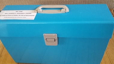
Document - Ken Clements Research Folder, 2014
... A comprehensive collection of documents, maps, book extracts and newspaper articles pertaining to the history of Peterborough. ...Peterborough History Group Peterborough great-ocean-road A comprehensive collection of documents, maps, book extracts and newspaper articles pertaining to the history of Peterborough. ...A comprehensive collection of documents, maps, book extracts and newspaper articles pertaining to the history of Peterborough. Researched and arranged by Ken Clements.An extensively researched collection of information in various forms indexed and arranged chronologically, portraying the timeline of Peterborough from Pre white settlement to 2014.Indexed expanding document folder containing individually researched information collated and indexed by Ken Clements.peterborough 3270