Showing 31 items matching " moliagul"
-
 Federation University Historical Collection
Map, Moliagul
... Moliagul...moliagul...Barker Library (top floor) Mount Helen goldfields moliagul welcome stranger nugget printed map with hand colouring Moliagul Map Map ...printed map with hand colouringmoliagul, welcome stranger nugget -
 Federation University Historical Collection
Document - Notes, James Stirling, Report on the Mining Features of Portion of the Moliagul and Dunolly Districts, 1899
... Report on the Mining Features of Portion of the Moliagul and Dunolly Districts...moliagul...Barker Library (top floor) Mount Helen goldfields moliagul dunolly 5 pages of photocopied and handwritten notes (located with 04473) Report on the Mining Features of Portion of the Moliagul and Dunolly Districts Document Notes James Stirling ...5 pages of photocopied and handwritten notes (located with 04473)moliagul, dunolly -
 Bendigo Historical Society Inc.
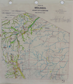
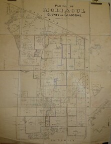
Map - JACK FLYNN COLLECTION: MOLIAGUL, 7/02/1931
... ...Moliagul...Map: Township of Moliagul, Parish of Moliagul, County of Gladstone. ...History House 11 Mackenzie Street Bendigo goldfields MAP Gladstone township Moliagul Map: Township of Moliagul, Parish of Moliagul, County of Gladstone. ...Map: Township of Moliagul, Parish of Moliagul, County of Gladstone. Parish plan.map, gladstone, township, moliagul -
 Bendigo Historical Society Inc.
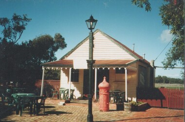
Photograph - EDITH LUNN COLLECTION: MOLIAGUL GENERAL STORE
... Moliagul...Moliagul General Store, relocated to Bendigo Pottery. 13A Exterior of the old store, sited at Bendigo pottery. 13B Notice on the history of the old store and Moliagul. ...Moliagul Bendigo Pottery Edith Lunn Moliagul General Store, relocated to Bendigo Pottery. 13A Exterior of the old store, sited at Bendigo pottery. 13B Notice on the history of the old store and Moliagul. ...Moliagul General Store, relocated to Bendigo Pottery. 13A Exterior of the old store, sited at Bendigo pottery. 13B Notice on the history of the old store and Moliagul. Welcome Stranger gold nugget found at Moliagul in 1869. Re John Flynn was born here in 1880.Edith Lunnmoliagul, bendigo pottery -
 Bendigo Historical Society Inc.
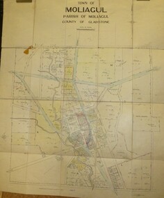
Map - JACK FLYNN COLLECTION: MOLIAGUL, October 1946
... ...Moliagul...Map: Parish of Moliagul, Sheet 1, County of Gladstone. Parish plan....History House 11 Mackenzie Street Bendigo goldfields MAP Gladstone parish plan Moliagul Map: Parish of Moliagul, Sheet 1, County of Gladstone. ...Map: Parish of Moliagul, Sheet 1, County of Gladstone. Parish plan.map, gladstone, parish plan, moliagul -
 Federation University Historical Collection
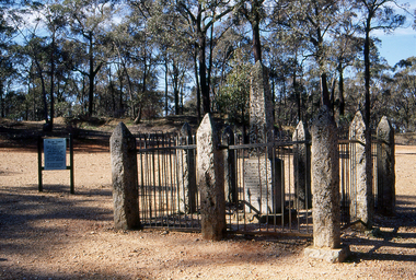
Slide, Welcome Stranger Monument, c1970
... The first recorded discovery of gold in Moliagul was in September 1852 and, before long, the area was flooded with over 4,000 miners. ...Photograph of the monument for the Welcome Nugget, a large gold nugget found by John Deason and Richard Oates at Moliagul....Barker Library (top floor) Mount Helen goldfields The first recorded discovery of gold in Moliagul was in September 1852 and, before long, the area was flooded with over 4,000 miners. ...The first recorded discovery of gold in Moliagul was in September 1852 and, before long, the area was flooded with over 4,000 miners. Two of those miners, John Deason and Richard Oates, had arrived in Bendigo in 1954 seeking their fortune. After eight years of little success, the friends moved to Moliagul and pegged a puddling claim. On 05 February 1869, Deason discovered a nugget near the roots of a tree, just 3cm beneath the soil. With the help of Oates, he uncovered the largest recorded alluvial gold nugget – known as the Welcome Stranger. The 61cm x 31cm nugget was taken to Dunolly to be measured on the bank’s scales, however at 69kg the gold needed to be broken on an anvil to actually fit on the scales.Photograph of the monument for the Welcome Nugget, a large gold nugget found by John Deason and Richard Oates at Moliagul.Obelisk inscription Welcome Stranger Nugget On this spot the largest nugget of gold in the world was discovered on the 5th February 1869 by John Deason and Richard Oates. Weight 2316 oz, Value £9553 Erected by the Mines Department 1897 Henry Foster Minister of Mines, D. J. Duggan M.L.A. Member for Dunollywelcome nugget, welcome nugget monument, john deason, richard oates -
 Bendigo Historical Society Inc.
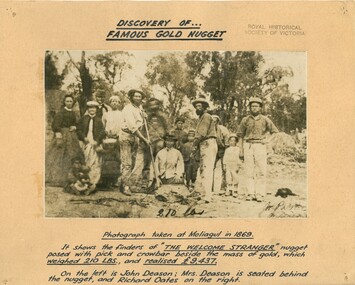
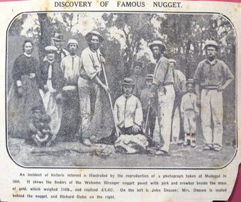
Photograph - MOUNTED PHOTOGRAPH OF THE DISCOVERY OF FAMOUS GOLD NUGGET 'WELCOME STRANGER' AT MOLIAGUL IN 1869
... ...Moliagul...Mounted black and white photograph of the discovery of gold, the "The Welcome Stranger" nugget at Moliagul in 1869 Nugget weighed 210 lbs. and realised £9,437. ...Gold mining Moliagul Welcome Stranger nugget Mounted black and white photograph of the discovery of gold, the "The Welcome Stranger" nugget at Moliagul in 1869 Nugget weighed 210 lbs. and realised £9,437. ...Mounted black and white photograph of the discovery of gold, the "The Welcome Stranger" nugget at Moliagul in 1869 Nugget weighed 210 lbs. and realised £9,437. Photograph shows the finders John Deason, his wife Mrs. Deason & Richard Oates Photo stamped "Royal Historical society of Victoria" Rear has a newspaper cutting of the event, with photograph, from the Argus September 9th, 1926gold mining, moliagul, welcome stranger nugget -
 Uniting Church Archives - Synod of Victoria
Photograph
... John Flynn Memorial, Moliagul. Gladys Smith and Bill Lidgett...John Flynn Memorial, Moliagul. Gladys Smith and Bill Lidgett Gladys Smith and Bill Lidgett Photograph ...Gladys Smith and Bill LidgettJohn Flynn Memorial, Moliagul. Gladys Smith and Bill Lidgett -
 Uniting Church Archives - Synod of Victoria
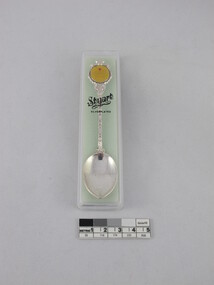
Souvenir teaspoon
... On front: "JOHN FLYNN MOLIAGUL CENTENARY 1880-1980" On reverse: "Stuart"...Uniting Church Archives - Synod of Victoria 54 Serrell Street Malvern East melbourne john flynn On front: "JOHN FLYNN MOLIAGUL CENTENARY 1880-1980" On reverse: "Stuart" G070.1 Souvenir teaspoon with the yellow disc with an image of a bi-plane and text in G070.2 a plastic presentation box. ...G070.1 Souvenir teaspoon with the yellow disc with an image of a bi-plane and text in G070.2 a plastic presentation box.On front: "JOHN FLYNN MOLIAGUL CENTENARY 1880-1980" On reverse: "Stuart"john flynn -
 Bendigo Historical Society Inc.
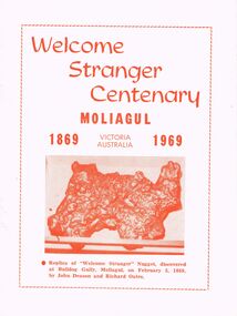
Document - WELCOME STRANGER CENTENARY, MOLIAGUL, VICTORIA, 5 Feb, 1969
... This booklet was prepared by Ronald L Carless, of Moliagul, Via Dunolly, and is dedicated to the gold miners who pioneered the Mount Moliagul goldfield....Document WELCOME STRANGER CENTENARY, MOLIAGUL, VICTORIA ...Welcome Stranger Centenary, Moliagul, Victoria, Australia 1869 1969. Replica of 'Welcome Stranger' Nugget, discovered at Bulldog Gully, Moligaul, on February 5, 1869, by John Deason and Richard Oates. History of gold nuggets in Australia in particular the 'Welcome Stranger.' 7 black and white photos. 1st photo is a group taken on site where the 'Welcome Stranger' nugget was discovered at Bulldog Gully, Moliagul, in February, 1869. John Deason is shown holding the shovel, and Richard Oates has the pick. Mrs Deason is seated on the ground. The gross weight of the nugget was 2,520 ounces. The nugget sold for 9,553 pounds and was 98.66 per cent pure gold. Henry Lawson's description of a goldfield would have been typical of Moliagul during the hectic goldrush days a century ago:- ''The yellow mounds of bullock With the spots of red and white, The scattered quartz that glistened Like diamonds in light; The azure line of ridges, The bush of darkest green, The little homes of calico That dotted all the scene.'' This booklet was prepared by Ronald L Carless, of Moliagul, Via Dunolly, and is dedicated to the gold miners who pioneered the Mount Moliagul goldfield.event, back to, welcome stranger centenary, welcome stranger centenary, victoria, australia 1869 1969. discovered at bulldog gully, moligaul, 5, 1869, john deason richard oates. gold nuggets in australia' black and white photos. mrs deason. gross weight of the nugget was 2, 520 ounces. the nugget sold for 9, 553 pounds 98.66 per cent pure gold. henry lawson's:- ''the yellow mounds of bullock with the spots of red and white -
 Bendigo Historical Society Inc.
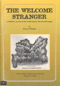
Book - BOOK: THE WELCOME STRANGER - A DEFINITIVE ACCOUNT OF THE WORLDS LARGEST ALLUVIAL GOLD NUGGET, 1999
... This alluvial gold nugget was discovered in 1869 at Moliagul, by Cornish miners, John Deason and Richard Oates. ...History House 11 Mackenzie Street Bendigo goldfields This alluvial gold nugget was discovered in 1869 at Moliagul, by Cornish miners, John Deason and Richard Oates. ...This alluvial gold nugget was discovered in 1869 at Moliagul, by Cornish miners, John Deason and Richard Oates. It's gross weight was 109.51 kg and net weight of gold was 72.02 kg. It was melted down and the ingots sent to the Bank of England.Softcover book with gold coloured cover with a sketch of the Welcome Stranger nugget on the front and a blurb on the back. Contains 50 pages covering the history, myths, geology, details of the discoverers and the discovery of the nuggett. Contains black and white photographs and sketches.Terry F Pottergold -
 Bendigo Historical Society Inc.
Newspaper - JACK PERRY COLLECTION: NEWSPAPER LIGHTNING HILL
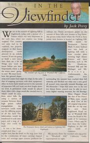
... Ida Heathcote, Pyramid Hill, Mt. Moliagul and Mt. Korong....Ida Heathcote, Pyramid Hill, Mt. Moliagul and Mt. Korong. Newspaper JACK PERRY COLLECTION: NEWSPAPER LIGHTNING HILL ...Newspaper article, Bendigo Weekly, on Lightning Hill and Permanent Survey Markers, their importance in mapping, drainage and sewerage planning. Marker on Lightning Hill shows distance and direction to Mr. Ida Heathcote, Pyramid Hill, Mt. Moliagul and Mt. Korong.person, individual, jack perry, lightning hill, permanent survey markers, windmill hill -
 Bendigo Historical Society Inc.
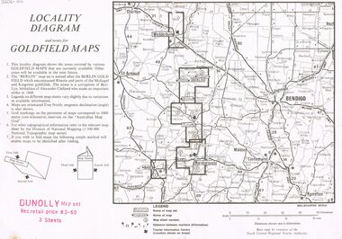
Document - JOAN O'SHEA COLLECTION: LOCALITY DIAGRAM AND NOTES FOR DUNNOLLY GOLDFIELD MAPS
... The Berlin field encompassed Rheola and parts of the Moliagul and Kingower goldfields. The name 'Berlin' is a corruption of Byrr Lyn, birthplace of Alexander Clelland who made an important strike in 1868....The Berlin field encompassed Rheola and parts of the Moliagul and Kingower goldfields. The name 'Berlin' is a corruption of Byrr Lyn, birthplace of Alexander Clelland who made an important strike in 1868. ...This locality diagram shows the areas covered by various goldfield maps. The Berlin field encompassed Rheola and parts of the Moliagul and Kingower goldfields. The name 'Berlin' is a corruption of Byrr Lyn, birthplace of Alexander Clelland who made an important strike in 1868.Joan O'Shea Collection. Locality diagram and notes for goldfield maps. Dunolly map set. Wedderburn, Berlin, Dunolly, Maryborough, Avoca.mining, company exploration, dunolly map set., berlin, kingower, wedderburn, gold mining -
 Eltham District Historical Society Inc
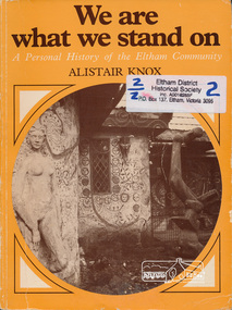
Book, Adobe Press, We are what we stand on : a personal history of the Eltham community / by Alistair Knox, 1980
... The chapters include: Justus Jorgensen & Montsalvat; the metamorphosis of the middle-class; the pise-de-terre connection; early building experiences; historic landmarks; the mud-brick revival; the Tarnagulla Dunolly Moliagul triangle; the Socio-Aesthetic Society; the renaissance of the Australian film industry; the Eltham inhabitants & their environment; the rediscovery of the Indigenous landscape; the Dunmoochin episode; the Dunmoochin potters; Clifton Pugh's success; the coming of the corporate state....Eltham District Historical Society Inc 728 Main Rd Eltham melbourne The chapters include: Justus Jorgensen & Montsalvat; the metamorphosis of the middle-class; the pise-de-terre connection; early building experiences; historic landmarks; the mud-brick revival; the Tarnagulla Dunolly Moliagul triangle; the Socio-Aesthetic Society; the renaissance of the Australian film industry; the Eltham inhabitants & their environment; the rediscovery of the Indigenous landscape; the Dunmoochin episode; the Dunmoochin potters; Clifton Pugh's success; the coming of the corporate state. justus jorgensen clifton pugh social customs ISBN: 0949909009 Paperback; xiii, 143 p. : ill. ...The chapters include: Justus Jorgensen & Montsalvat; the metamorphosis of the middle-class; the pise-de-terre connection; early building experiences; historic landmarks; the mud-brick revival; the Tarnagulla Dunolly Moliagul triangle; the Socio-Aesthetic Society; the renaissance of the Australian film industry; the Eltham inhabitants & their environment; the rediscovery of the Indigenous landscape; the Dunmoochin episode; the Dunmoochin potters; Clifton Pugh's success; the coming of the corporate state.Paperback; xiii, 143 p. : ill. ISBN: 0949909009justus jorgensen, clifton pugh, social customs -
 Tarnagulla History Archive
Article: The Strangers 110th birthday, The Strangers 110th birthday, February 3, 1979
... moliagul...Tarnagulla History Archive Tarnagulla Public Hall 69-71 Commercial Rd Tarnagulla goldfields Murray Comrie Collection. moliagul gold nuggets prospecting welcome stranger One page of the Bendigo Advertiser with article titled 'The Strangers 110th birthday'. ...Murray Comrie Collection. One page of the Bendigo Advertiser with article titled 'The Strangers 110th birthday'. About the Welcome Stranger. moliagul, gold, nuggets, prospecting, welcome stranger -
 Bendigo Historical Society Inc.
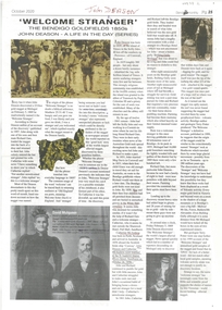
Newspaper - Newspaper article re john Deason - A Life in the Day Series, "Welcome Stranger" The Bendigo Goldfields 1850s, John Deason - A Life in the Day (Series)
... Left the Bendigo Goldfields for Bulldog Gully Moliagul. Discovered the Welcome Stranger nugget 5 February 1869. ...Left the Bendigo Goldfields for Bulldog Gully Moliagul. Discovered the Welcome Stranger nugget 5 February 1869. ...John Deason born 1829 on island of Tresco in the Scilly Isles. 1841 worked in Cornish tin mine. 1851 married Meg Davis, along with Richard Oates travelled to Bendigo Goldfields. By 1858 Meg and the four children were dead. John married Catherine McAndrew 28 October 1858. Left the Bendigo Goldfields for Bulldog Gully Moliagul. Discovered the Welcome Stranger nugget 5 February 1869. Newspaper article from The Bendigo Monthly October 2020 Page 25, Includes copies of photographs and other newspaper articles within the story. Story of John Deason, and the discovery of the Welcome Stranger Gold Nugget. -
 Bendigo Historical Society Inc.
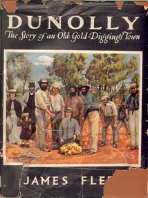
Book - ALEC H CHISHOLM COLLECTION: ''DUNOLLY, THE STORY OF AN OLD GOLD-DIGGINGS TOWN''
... Coloured copy of the photo of the discovery of the 'Welcome Stranger' nugget at Moliagul in 1869 opposite title page....Coloured copy of the photo of the discovery of the 'Welcome Stranger' nugget at Moliagul in 1869 opposite title page. Book ALEC H CHISHOLM COLLECTION: ''DUNOLLY, THE STORY OF AN OLD GOLD-DIGGINGS TOWN'' ...Book. ALEC H CHISHOLM COLLECTION. 160 page hardcover 'coffee table' book on the history of the gold rushes at Dunolly and surrounding district by James Flett. Includes 7 maps and 41 illustrations. Published in 1956 by the Poppet Head Press and printed by George H Barrow & Co., Melbourne. Catalogue sticker ''2256 FLE'' on spine. Coloured copy of the photo of the discovery of the 'Welcome Stranger' nugget at Moliagul in 1869 opposite title page.James Flettbooks, collections, history, alec h chisholm collection, james flett, dunolly, gold rush -
Bendigo Historical Society Inc.
Map - TARNAGULLA : COUNTY OF BENDIGO, 13-5-22
... County of Bendigo, County of Gladstone.Inglewood, Glenalbyn, Kingower, Moliagul, Waanyarra, Laaneoorie, Woodstock, Loddon River, Township of Tarnagulla, Township of Newbridge, Township of Llanelly, Dunolly to Inglewood Railway, Tarnagulla Rifle Range, Laurie Station, Bullabul Creek, Arnold Township, Arnold Railway Station. ...County of Bendigo, County of Gladstone.Inglewood, Glenalbyn, Kingower, Moliagul, Waanyarra, Laaneoorie, Woodstock, Loddon River, Township of Tarnagulla, Township of Newbridge, Township of Llanelly, Dunolly to Inglewood Railway, Tarnagulla Rifle Range, Laurie Station, Bullabul Creek, Arnold Township, Arnold Railway Station. ...Map. County of Bendigo, County of Gladstone.Inglewood, Glenalbyn, Kingower, Moliagul, Waanyarra, Laaneoorie, Woodstock, Loddon River, Township of Tarnagulla, Township of Newbridge, Township of Llanelly, Dunolly to Inglewood Railway, Tarnagulla Rifle Range, Laurie Station, Bullabul Creek, Arnold Township, Arnold Railway Station. Photo-Lithographed at the Department of Lands and Survey, Melbourne by W.J. Butson, 13-5-22.Price 1/-.By authority A.J. Mullett, Government Printer, Melbourne. (number 118 in map cupboard 1)A.J. Mullett, Government Printer, Melbourne.map, bendigo, tarnagulla -
Bendigo Historical Society Inc.
Map - TARNAGULLA : COUNTY OF BENDIGO, 1959
... Tarnagulla, County of Bendigo, County of Gladstone, Inglewood, Glenalbyn, Kingower, Moliagul, Painswick, Waanyarra, Laanecoorie, Woodstock, Derby, Loddon River, Dunolly to Inglewood Railway, Laurie Railway Station, Township of Tarnagulla, Tarnagulla Rifle Range, Township of Llanelly, Arnold Railway Station, Bullabul Creek, Kangderaar Creek, Township of Newbridge. ...Tarnagulla, County of Bendigo, County of Gladstone, Inglewood, Glenalbyn, Kingower, Moliagul, Painswick, Waanyarra, Laanecoorie, Woodstock, Derby, Loddon River, Dunolly to Inglewood Railway, Laurie Railway Station, Township of Tarnagulla, Tarnagulla Rifle Range, Township of Llanelly, Arnold Railway Station, Bullabul Creek, Kangderaar Creek, Township of Newbridge. ...Map. Tarnagulla, County of Bendigo, County of Gladstone, Inglewood, Glenalbyn, Kingower, Moliagul, Painswick, Waanyarra, Laanecoorie, Woodstock, Derby, Loddon River, Dunolly to Inglewood Railway, Laurie Railway Station, Township of Tarnagulla, Tarnagulla Rifle Range, Township of Llanelly, Arnold Railway Station, Bullabul Creek, Kangderaar Creek, Township of Newbridge. By authority A.C. Brooks, Government Printer, Melbourne. Drawn and reproduced at the Department of Lands and Survey, Melbourne, 1959. (number 117 in map cupboard 1)A.C. Brooks, Government Printer, Melbourne.map, bendigo, tarnagulla -
 Bendigo Historical Society Inc.
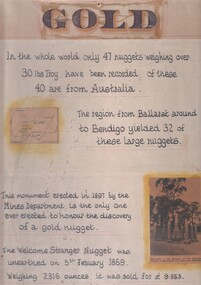
Document - 'GOLD' POSTER WITH DESCRIPTION OF NUGGETS
... A photo of the monument to the discovery of the 'Welcome Stranger' nugget found 1 1/4 miles from Moliagul in the bottom corner....A photo of the monument to the discovery of the 'Welcome Stranger' nugget found 1 1/4 miles from Moliagul in the bottom corner. Document 'GOLD' POSTER WITH DESCRIPTION OF NUGGETS ...Poster heading - 'Gold' - 'In the whole world, only 47 nuggets weighing over 30lbs Troy have been recorded. Of these 40 are from Australia. The region from Ballarat around to Bendigo yielded 32 of these large nuggets. This monument erected in 1897 by the Mines Department, is the only one ever erected to honour the discovery of a gold nugget. The 'Welcome Stranger' nugget was unearthed on 5th February, 1869, weighing 2316 ounces and it was sold for 9.553 pounds'. Poster includes a map of Victoria depicting the main gold mining areas, also mention of gypsum, and tin in northern Victoria. A photo of the monument to the discovery of the 'Welcome Stranger' nugget found 1 1/4 miles from Moliagul in the bottom corner.document, gold -
 Federation University Historical Collection
Book, Memoirs of the Geological Survey of Victoria No 11. The Maryborough Goldfield, 1913, 1913
... ...moliagul...Barker Library (top floor) Mount Helen goldfields maryborough memoirs of the geological survey of victoria d.j. mahony maryborough goldfield geology faults welcome nugget richard oates mrs deason moliagul larkinville nugget m. larcombe john deason eucalypts Pink soft covered book of 76 pages and 7 plates. ...Pink soft covered book of 76 pages and 7 plates. Includes two loose newsclips .2) The Larkinville Nugget (The Age 21 Jan 1931) .3) Discovery of the Welcome Nuggetmaryborough, memoirs of the geological survey of victoria, d.j. mahony, maryborough goldfield, geology, faults, welcome nugget, richard oates, mrs deason, moliagul, larkinville nugget, m. larcombe, john deason, eucalypts -
 Bendigo Historical Society Inc.
Document - TAILINGS MAGAZINE 1966: ''EARLY DAYS IN THE TARNAGULLA DISTRICT''
... ... Moliagul...Haines Bulabul Creek Soho Foundry Mr Cheetham Mr Andrew Mitten Arnolds Bridge Newbridge Moliagul DDunolly Goldfields Historical Society Author: Don Clark. ...''Early Days in the Tarnagulla District'' (from two issues of 'Tailings' magazine-the monthly newsletter published by the Goldfields Historical Society, 1966). Two pages relate to this topic although it is stated that the second issue would lead to more in the third. However, , the third page is another page from the Tailings magazine but not related to the area. Author of material - Don Clark, Llanelly. Many references to people and locations in the areaGoldfields Historical Society Author: Don Clark.bendigo, history, goldfields historical society, tailings, goldfields historicl society, cheese factory irishtown, murphy's creek, mr w. haines, bulabul creek, soho foundry, mr cheetham, mr andrew mitten, arnolds bridge, newbridge, moliagul, ddunolly -
 Bendigo Historical Society Inc.
Slide - Images by Arthur Pulfer, 1957-1970
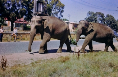
... Twenty Slides of Bendigo: 7795.5a Market Gardens - possibly North Bendigo 7795.5b North Deborah Mine photo taken from Breen Street 1958 7795.5c Laying the track to get the engine into the park, looking down Mitchell Street Bendigo 7795.5d R766 in the Victorian Railways Institute Park Railway Place Bendigo 7795.5e On the Methodist Church Steps Arnold street Bendigo 7795.5f Caralulup Hotel near Talbot Victoria 7795.5g Miner's Hut at Moliagul 7795.5h Tolmer's Gold Route Victoria to South Australia 7795.5i Basket Lunch - White Hills Botanical Gardens - St johns 100 year celebrations 7795.5j White Hills Swimming Pool February 1970 7795.5k White Hills Botanical Gardens Bendigo 7795.5l Bendigo Show Parade 1958 7795.5n Bullens Circus Bendigo February 1966 7795.5o The old Lockup Eaglehawk Bendigo September 1967 7795.5p The old Golden Gully Hotel Diamond Hill Road, Bendigo 7795.5q Roseview Pethards Home 407 High Street Golden Square Bendigo 25th March 1957 7795.5r House - possibly on the Midland Highway Epsom, Bendigo - 8 April 1955 7795.5s The Big Tree Sedgwick Road March 1972 7795.5t Kangaroo Flat Bus Lines mini bus 7795.5m The Arrival of the Cobb and Co Coach in Bendigo September 1963 7795.5n Bullens Circus Bendigo February 1966 - two elephants walking along the Bendigo Creek...Twenty Slides of Bendigo: 7795.5a Market Gardens - possibly North Bendigo 7795.5b North Deborah Mine photo taken from Breen Street 1958 7795.5c Laying the track to get the engine into the park, looking down Mitchell Street Bendigo 7795.5d R766 in the Victorian Railways Institute Park Railway Place Bendigo 7795.5e On the Methodist Church Steps Arnold street Bendigo 7795.5f Caralulup Hotel near Talbot Victoria 7795.5g Miner's Hut at Moliagul 7795.5h Tolmer's Gold Route Victoria to South Australia 7795.5i Basket Lunch - White Hills Botanical Gardens - St johns 100 year celebrations 7795.5j White Hills Swimming Pool February 1970 7795.5k White Hills Botanical Gardens Bendigo 7795.5l Bendigo Show Parade 1958 7795.5n Bullens Circus Bendigo February 1966 7795.5o The old Lockup Eaglehawk Bendigo September 1967 7795.5p The old Golden Gully Hotel Diamond Hill Road, Bendigo 7795.5q Roseview Pethards Home 407 High Street Golden Square Bendigo 25th March 1957 7795.5r House - possibly on the Midland Highway Epsom, Bendigo - 8 April 1955 7795.5s The Big Tree Sedgwick Road March 1972 7795.5t Kangaroo Flat Bus Lines mini bus 7795.5m The Arrival of the Cobb and Co Coach in Bendigo September 1963 7795.5n Bullens Circus Bendigo February 1966 - two elephants walking along the Bendigo Creek Slide Images by Arthur Pulfer. ...Arthur William Pulfer was born on 18 April 1918, in Bendigo, Victoria, Australia, his father, Harold Victor Pulfer, was 30 and his mother, Elsie Maud Rumball, was 26. He married Norma Stewart in Bendigo, Victoria, Australia. He died on 6 March 2001, in his hometown, at the age of 82, and was buried in the Bendigo Cemetery. ROSEVIEW 407 High Street, Golden Square Bendigo "Roseview" was designed by Godfrey Eathorne and constructed in 1939. It is one of the few Streamline Moderne houses in the Central Goldfields region, and was one of the earliest constructed in the Bendigo region. It is an outstanding example of this style of housing. It resembles an ocean liner, and reflects the emphasis on the streamlining of methods of transportation. It utilizes both flat and curved surfaces and has little external ornamentation. The use of materials such as rounded glass windows and metal window and door frames reflects an innovative approach to construction consistent with the style. "Roseview" was constructed on a large scale, with large and spacious rooms. It reflects the prominent social status and wealth of the original owner, together with the desire for a building in 'the latest' style which was sure to attract attention and prominence in the region. It has been maintained largely in original condition. CARALULUP HOTEL 'The Sun' dated January 17, 1941 on the back. It states that 'The licence of Caralulup Hotel, near Talbot, has been surrendered, thus severing an 80 year association with the district' State Library of Victoria TOLMER GOLD ESCORT ROUTE The gold rush in New South Wales and Victoria left few able miners in South Australia. Bad economic conditions saw more than 15,000 men leave the Kapunda and Burra mines by the end of 1851. Alexander Tolmer, Commissioner of Police in 1852 proposed that the gold won by South Australians should be brought back to South Australia under an escort consisting of only a few men. In March a Gold Escort was on its way back to Adelaide with almost 6,000 ounces of gold for the vaults of the Treasury Building. After this successful trip Tolmer led two other escorts before handing over his duties. A total of eighteen gold escorts were made, the last one during November and December 1853 when Inspector Wyndham was in charge. You’ll find Gold Escort Route Monuments between Meningie, Coonalpyn and Tintinara.Many images from by Arthur Pulfer copied to slides. Twenty Slides of Bendigo: 7795.5a Market Gardens - possibly North Bendigo 7795.5b North Deborah Mine photo taken from Breen Street 1958 7795.5c Laying the track to get the engine into the park, looking down Mitchell Street Bendigo 7795.5d R766 in the Victorian Railways Institute Park Railway Place Bendigo 7795.5e On the Methodist Church Steps Arnold street Bendigo 7795.5f Caralulup Hotel near Talbot Victoria 7795.5g Miner's Hut at Moliagul 7795.5h Tolmer's Gold Route Victoria to South Australia 7795.5i Basket Lunch - White Hills Botanical Gardens - St johns 100 year celebrations 7795.5j White Hills Swimming Pool February 1970 7795.5k White Hills Botanical Gardens Bendigo 7795.5l Bendigo Show Parade 1958 7795.5n Bullens Circus Bendigo February 1966 7795.5o The old Lockup Eaglehawk Bendigo September 1967 7795.5p The old Golden Gully Hotel Diamond Hill Road, Bendigo 7795.5q Roseview Pethards Home 407 High Street Golden Square Bendigo 25th March 1957 7795.5r House - possibly on the Midland Highway Epsom, Bendigo - 8 April 1955 7795.5s The Big Tree Sedgwick Road March 1972 7795.5t Kangaroo Flat Bus Lines mini bus 7795.5m The Arrival of the Cobb and Co Coach in Bendigo September 1963 7795.5n Bullens Circus Bendigo February 1966 - two elephants walking along the Bendigo Creekhistory, bendigo, james lerk collection, golden square high school, dragon loong, white hill botanical gardens, 407 high street bendigo, r766 engine, bullens circus, caralulup, moligual, bendigo show, tolmer's gold route, kangaroo flat bus lines, eaglehawk lockup, arnold street methodist church, elephants, arthur pulfer -
Federation University Historical Collection
Document, Zelda Martin, Central Victorian Goldmining towns - Boom Towns or Ghost Towns?, c1996
... ...Moliagul...Randell Majorca: *Brief History *Official Post Office Directory 1869 - Name / Occupation/ Address Maldon (Tarrangower): *Brief History Part 1 *Brief History Part 2 *Post Office Directory *List - Alphabetical Order by Names plus Business and Trade (Tarrangower Times Oct/1858) *List - Alphabetical Order by Trade plus Name and Business *Directory - Name / Occupation / Dwelling Maryborough: *Worsley Cottage - built by Arthur Worsley, a contractor in stonework in 1894 [.11] Resource No. 4 Blue Display Book titled Towns 4 Moliagul to Stawell Moliagul: *Brief History *Moligul Legislative Assembly (Voting?) ...Randell Majorca: *Brief History *Official Post Office Directory 1869 - Name / Occupation/ Address Maldon (Tarrangower): *Brief History Part 1 *Brief History Part 2 *Post Office Directory *List - Alphabetical Order by Names plus Business and Trade (Tarrangower Times Oct/1858) *List - Alphabetical Order by Trade plus Name and Business *Directory - Name / Occupation / Dwelling Maryborough: *Worsley Cottage - built by Arthur Worsley, a contractor in stonework in 1894 [.11] Resource No. 4 Blue Display Book titled Towns 4 Moliagul to Stawell Moliagul: *Brief History *Moligul Legislative Assembly (Voting?) ...Zelda Martin was a PhD candidate at the University of Melbourne.[.1] 4th item in light blue display book titled Research Approach/Overview of Chapters/Confirmation of Canditure/Chapters1,2,3&4 of proposed thesis. *Twenty-seven page article on Victorian goldfields towns titled: Central Victorian Goldmining Towns - Boom Towns or Ghost Towns. The article was written during the author's PhD study. It outlines the context methodology, and resources and the chapters of the proposed thesis: (1) Central Victorian Goldmining Towns - The Context (2) Contemporary Views of the Factors Necessary for Town Growth (3) Outward Manifestations of Town Growth (4) The Trappings of Government (5-9) The Main Towns and Their Hinterland. [.2] 5th item in Light Blue display book as above item. *Chapter 1 of proposed thesis titled 'Pick, Shovel and Tin Dish Mining.' Covers in Section A: Central Victoria - Pre 1851: Aborigines in Central Victoria, Squatters, and Government. Section B: The years 1851-1854: The Early Gold Rushes, Government Reaction, Township Surveys, Legislation, Town Development, Local Government and Early Settlement. [.3] 6th item in Light Blue display book as above item. *2A of proposed thesis titled 'Contemporary Views of the Factors Necessary for Town Growth'. Similar information to Chapter 1 plus extra re towns and maps. Sections: Introduction, Context of Place - Geographical Towns Listed, The Context of Time - Pre1851 Aborigines, Governance of Port Phillip, The Squatters, The Villages of Central Victorian Highlands, Conclusion, Condensed Version of Chapter2B. [.4] 7th item in Light Blue display book as above item. *Chapter2B of proposed thesis. Sections: Area of Research, Schools, Banks, Newspapers, Progress Association, Town Development - Sandhurst (Bendigo), Ballarat, Castlemaine,, Maryborough, Ararat and Stawell. [.5] 8th item in Light Blue display book as above item. *Chapter 3 of proposed thesis titled 'Outward Manifestations of Town Growth'. Sections: Introduction, Contemporary Writing, Educationalists, The Bankers, The Townsfolk, Current Theory, General Theories of Urban Development, and Conclusion. [.6] 9th item in Light Blue display book as above item. *Chapter 4 of proposed thesis titled 'Trappings of Government' Sections: Introduction, Early Government Attitudes to Mining and Town Development, Law and Order, Township Surveys, Legislation, Local Government, Transport and Communication, The People and Lobbyists. [.7] 10th item in Light Blue display book as above item. *'The Rise and Fall of Central Victorian Goldmining Towns'. Includes a map showing main Goldfields, a table showing towns and villages at two points in time - 1857 and 1871; a Bibliography of Primary and Secondary Sources. [.8] Resource No1. Black display book titled Local Towns 1 : Alma: *Brief history *Directory *Maps Amphitheatre / Mountain Hut: *Brief History Post Office Directory Ararat: *Brief History *Post Office Directory 1869 - Alphabetical Listing by Occupation *Ararat - Prominent Citizens of 1858 *Langi-Morgala Museum Avoca: *Brief History *Excerpts from 'Avoca The Early Years', Margery and Betty Beavis; pg1 - Beginnings; pg11 - The Midas Touch; pg25 - Local Gold Escorts; pg27 - A Town is Born; pg51- The Administration of Justice; pg53 - The Ways of the Law; pg61 - News of the Day; pg65 - A Time to Play; pg72 - Land Ownership *Post Office Directory (Bailliere's) 1869 *Tourism Map and Information of area *Historic Avoca - A 5.5km Tour *Avoca & the Pyrenees Region - information pamphlet Ballarat: *Early History of Ballarat - Ballarat Historical Society, Publication No.1: origin of the name; Ballaarat - the Beginning; Fabulous Yields from the Ballaarat Goldfield; *Streetscape Lydiard Street. *Hand drawn map showing Leigh River, Old Portland Bay Road, plaque on road to Colac; etc. *Newspaper article re 'The Theatre Royal' ( which stood in the vicinity of the current Owen Williams store) - 'The News'15/04/1998 *Article - 'Ballarat's Mechanics' Institute Lives On' Ballarat Courier, 14/09/1985 *Article - Standing the Test of Time' The News 17/11/1993 re The Mechanics Institute & picture of the Reading Room *'Ballarat a Study of a City, Phyllis Reichl, pub. Nelson, 1968; no.3 place, time and people field studies series *Investigator Vol.33 No.2, 1998 Geelong Historical Society. Article on pg75 describes Ballarat in 1861 *Folded poster - 'Ballarat 100' a history of telegraph communication, pub. Telecom. Beaufort (Fiery Creek): *Brief history *Post Office Directory [.9] Resource No.2 Black Folder Titled Towns cont.No2 Bendigo (Sandhurst): *'Family & Local History at the Bendigo Library - 1851-2001 150 years of gold'. *Bendigo Government Camp in 1853 illustration; key to sketch and names of Government officers stationed there *Excerpts from 'Bendigo and Vicinity' Adolph Haman *The Bendigo Goldfield Registry - pgs 1-7 Introduction *Excerpt: 'Breaking the Grip' *Excerpt: The Most Go-Ahead Place *Excerpts from 'History of Bendigo' - anti license agitation; laying out of town; proposed railway; gold calls and dividends; the Sandhurst Municipality; journalism *Bibliography Blackwood: *Excerpts from 'Aspects of Early Blackwood - The Goldfield, the Landmarks, the Pioneers' Alan J Buckingham and Margaret F Hitchcock, JG Publishing,1980 Buninyong: *A Brief History *Investigator Vol1 No.2 Feb 1966 Geelong Historical Society. Pg3 - Article re gold escort route - Mt Alexander to Adelaide - (see a simple monument on the Western Highway a few miles out of Horsham. Pg 15 - Ballarat Excursion - re the finding of gold. *Three articles published by Buninyong and District Historical Society Inc: (Magpie Exploration; Finding Gold In The Green Hills; Magpie Exploration; Burnt Bridge to Cargarie to Mt Mercer) *Copies of newspaper articles/items *Buninyong Street Directory Carisbrook: *In the Beginning There Was Carisbrook *The History of the Carisbrook Racecourse Carngham / Snake Valley: *Brief History *Directory Castlemaine: *Directory 1865-1866 - Alphabetical and Street *Poster - Castlemaine A Contemporary Guide "The Great Centre" 1866 - A Contemporary Guide to the Fascinating Past *Pamphlet - Castlemaine District Community Hospital *Map - Castlemaine, Maldon & Surrounding Districts *Map and Information - The Dry Diggings Track - a 55kl walk among historic goldfields relics ( Castlemaine Fryerstown Vaughan Mt Franklin Hepburn Daylesford) *Postcard - Former Court House *Directory 1867 - Alphabetical, Trade [.10] Resource No.3 Grey folder Titled Towns 3 Creswick to Maryborough Creswick: *Brief History *Booklet - "Creswick Cemetery Walk" *Booklet - The Buried Rivers of Gold Heritage Trail Creswick *Creswick Historical Museum Information Sheet *Chronological History of Creswick *Alphabetical Directory of the Borough of Creswick *Creswick's Creek Directory 1856 *Historic Creswick Walking Tour *A Brief Account of the Schools of Creswick - Past and Present *100 Years of Railway Travel in Creswick *The Berry Deep Leads *The Spence Home at Jackass Gully in the Creswick State Forest ( William Guthrie Spence - Pioneer) *The New Australian Mine and the 1882 Disaster *Creswick District News, Issue 7, July August 1999 *The Creswick Miners Walk - Information and Map *Maps Chewton: *Brief History *Directory Clunes: *Brief History *Clunes Street Directory Daylesford: *Brief History *Notable Bushfires in Daylesford District Over More Than a Century - "Black Thursday" 1851; 1862; 1899; the Disastrous Hepburn Fire of 1906; 1939; 1944; 1969. *Post Office Directory -Daylesford and Hepburn Dunolly / Inkerman: *Brief History *Directory *Pamphlet - Goldfields Historical Museum *Pamphlet - Historic Dunolly - Victoria's Best Kept Secret *Map of Gold Workings at Dunolly Area - showing where the main gold rushes occurred *Brief History - Inglewood *Directory - Inglewood - Name Occupation, Dwelling Kingower: *Brief History *Directory - Name / Ocupation / Dwelling Linton / Happy Valley / Piggoreet: *Brief History *Directory - Lintons McIvor: *"A History of the Shire and the Township of Heathcote" by J.O. Randell Majorca: *Brief History *Official Post Office Directory 1869 - Name / Occupation/ Address Maldon (Tarrangower): *Brief History Part 1 *Brief History Part 2 *Post Office Directory *List - Alphabetical Order by Names plus Business and Trade (Tarrangower Times Oct/1858) *List - Alphabetical Order by Trade plus Name and Business *Directory - Name / Occupation / Dwelling Maryborough: *Worsley Cottage - built by Arthur Worsley, a contractor in stonework in 1894 [.11] Resource No. 4 Blue Display Book titled Towns 4 Moliagul to Stawell Moliagul: *Brief History *Moligul Legislative Assembly (Voting?) List - Names and Occupations *Moliagul Victorian Post Office Directory 1868 - Name / Ocupation / Address / Comments *"The Welcome Stranger" gold nugget *The Sunday School *The Welcome Stranger Discovery Walk - information and map Moonambel (Mountain Creek) Redbank *Brief History *List of names extracted from advertisments of the Pioneer and Mountain Creek Advertiser 16/02/1861. *Bailliere's Directory 1869 - Alphabetical List of Name / Occupation / Place St Arnaud: *Brief History Sebastapol: *Brief History *Directory 1869 - Alphabetical by Name; plus occupation and address. Browns and Scarsdale: *Brief History *Browns Street Directory - Name and Occupation Smythesdale: *Brief Description *Smythesdale Street Directory -Name and Occupation Stawell (Pleasant Creek) *Brief History *Victorian Official Post Office Directory - Name /Occupation / Dwelling *Chronology - 1841-1920 *Production of gold statistics - 1879 - 1900 *Big Hill *Extracts from "The Golden Years of Stawell". Chapt 1 - Stawell's Coming Out. Capt. 2 - The Gold Rush. Caapt.3 - Cradle of Democracy. Chapt.4 - The Reefs Becomes Stawell. Chapt. 5 - Rushing In. Chapt.6 - The Pioneers. Chapt 7 - The Decade of Optimism. [.12] Resource No. 5: Blue Display Book titled 'Towns Steiglitz to the The Golden Triangle. Steiglitz: Brief History Victorian Post Office Directory 1869 *Map of Steiglitz *List of maps relevant to Steiglitz history *Information 6 tables of data from "Reports of Mining Surveyors Talbot (Back Creek) Brief History Taradale: Post office Directory 1869 - Name/Occupation/Street. Also list in alphabetical order by Occupation Taradale *Chronological Reference to Taradale Mines *Water - The Coliban System of Waterworks *Joseph Brady *The Syphon Tarnagulla (Sandy Creek) *Brief History *Tarnagulla Businessmen Cameos to give depth to advertisments in 'The Tarnagulla Courier' various issues 1864-1871 *Directory - Name/Occupation /Address *List - Name/Business/Trade Wedderburn (Koorong) *Brief History *List - Name/Occupation The Golden Triangle: *The Early Rushes - Wedderburn / Moliagul / Sandy Creek - Tarnagulla / Jones Creek - Waanyarra / Kingower / Dunolly - Goldsborough / Inglweood *Census of 1857 - Population / Occupations *1858-1871 - A Time of Consolidation- Wedderburn / Moliagul / Sandy Creek- Tarnagulla / Arnold *Census 1871 - Population *Information gleaned from the census data - Demographics / Population / Occupations / marital / Birthplace / Religion / Literacy/ Occupation and Housing Cameos *Graphs - Birthplace of settlers /Male-Female Ratio / Married males / Children under 15 as Percentage of Population / Religion *Census 1857 - Statistical data *Maps *Bibliography [.13] Resource No. 6 - Black Display Book Information and Research in Central Victoria including: *Banking - Research from ANZ Bank Archives *Institutions - also includes articles listed from the Ballarat Times Newspaper *Australian mining History Association - A.M.H.A. Bibliography *Australia's Mining History * Bibliography - Land Surveys Victoria - *1853 Administration (Statistics and Other) includes: schools / ministers of religion / police / military / local administration / licences for sale of spirits / distances between various Victorian gold fields. * Victoria Government Gazette (Copy) - N0. 116, 12/12/1854 includes: Gold Felds Commission of Enquiry & No. 85, 15/09/1854 - Addresses presented to the Lieutenant Governor (Sir Charles Hotham) during his tour through the Gold Fields of Victoria,1854. Addresses on behalf of : the people of Bendigo; Members of the Church of England, Bendigo; Members of the Wesleyan Church on the Bendigo Gold Fields; Bendigo Gold District General Hospital; the Bendigo Prospecting Association; Committee of the Bendigo Local Exhibition; Bendigo District Medical Association; Coloured Americans Resident at Bendigo; German Inhabitants of Bendigo; Landowners, Inhabitants, and Miners of Castlemaine; Inhabitants of Forest Creek; Inhabitants of Heathcote and Gold Miners of McIvor; Residents and landholders of the District of Bacchus Marsh; Inhabitants of Kilmore and Vicinity. *Gold Fields Correspondence 1853: letter from Lieutenant Colonel Valiant, (Officer commanding the Troops in Victoria) to the Lieutenant Governor re threatened disturbance at Sandhurst (Bendigo) regarding the Gold License Fee. * Extracts from a book "Victoria" re Gold Fields Commission of Enquiry involving mainly Ballarat and Castlemaine and a chapter titled 'A Tour to the Victorian Gold-Fields' *Lists of central Victorian newspapers - listed by date published 1851to 1874; by first date available to State Library. *A list of cities and towns showing County, population in 1861 &1871, and municipal status. [.14] Resource no.7. Black display book. *Reference: Papers presented to Parliament Victoria - 1859-1860 4 volumes - relevant sections copied. Contains information on Branches of Government. General / Finance / Gold / Gazette / Commission and Warrant / Statistic. *Gold Fields Act. In accordance with the Act the gold fields are divided into six districts - Ballaarat, Castlemaine , Sandhurst, Avoca, Ararat, and Beechworth.. Official staff in each gold district consists of a Resident Warden, Wardens, Wardens' Clerks, Bailiffs, Chinese Protectors, Chinese Interpreters, and Mining Surveyors. *Gold Receiver *Gaols *Police magistrates and Clerks of Petty Sessions, etc. *Field Branch *Immigration and Emigration Overland - Chinese - 1859 *Population on the Goldfields *The Geological Survey - The Government Geologist is assisited by staff from four branches - the office Branch; the Publishing Branch; the Field Branch and the Museum Branch. *Commission to Enquire Into Sludge dated 10/02/1859 (Some sections copied) - Report to the Honorable Chief Commissioner of Public Works, Melbourne re the mode of carrying the sludge from the puddling mills in Sandhurst without interfering with the drainage of the town and the roads in the neighbourhood. [.15] Resource No.8: Camel display book titled Resource No. 8. Aborigines *Lists of book titles - +"Readings in Victorian prehistory" +"The Aborigines of Port Phillip" +Aboriginal languages and clans" +"A History of the Port Phillip District" +"Langi Ghiran 1: Aboriginal Rock...." +"Koorie History: sources for aboriginal studies in the State Library of Victoria", ed. Tom Griffiths, Melb. Friends of the State Library, 1989 +"The Public Lands of Australia Felix"; settlement and land appraisal in Victoria1834-91 with special reference to the Western Plains", J.M.Powell, Melb. Oxford University Press 1970 +*Bibliography of the Victorian Aborigines' from the earliest manuscripts to 31st December 1970, Massoa, Aldo, Melb. Hawthorn Press, 1971 +"Aborigines in Colonial Victoria, 1836-1886", M.F. Christie, Sydney University Press, 1979 +"Urban and Industrial Australia: readings in Human Geography" ed J.M. Powell, Melb. Sorrett Pub. 1974 *Extracts: -Processes of Pioneer Settlement - The Squatting Occupation of Victoria, 1834-60. J.M. Powell -Areal Variations in the Class Structure of the Central-Place Hierarchy. P. Scott - Volume1 and Volume 2: Notes Relating to the Habits of the Natives of Other Parts of Australia and Tasmania. Compiled from various sources for the Government of Victoria by R Brough Smyth. John Curry, O'Neil, Melb. 1st pub. Melb. 1876. p31-45 - Numbers and Distribution of the Aborigines in Victoria -Victorian Aborigines 1835-1901 - A Resource Guide to the Holdings of the Public Record Office, Victoria; published by the Government Information Centre 1984. *History of the Aboriginal Artefacts Displayed in the Daylesford Museum. F. G. Powell (4 page pamphlet) *Letter to Zelda Martin from Peter Lovett, Cultural Officer, Ballarat & District Aboriginal Co- Operative, 05/02/1997 *Map: Ian Clarke Victorian Tribunal Boundary Map - Clans of Central Victoria. *Victorian Rock Art and Mythology - Article about Mount Langhi Ghiran and myths of the Tjapwarong people. *Two Aboriginal myths relating to the Grampians - 'The Monster Emu' / 'The Aquisition of Fire', by the Aborigines in the Grampians Areas *Article titled (chapter 8) Ballarat - information re camping sites in the region. Lake Wendouree / Lake Burrumbeet (includes a myth) / Mt Bunninyong / Lal Lal / Pitfield / Mount Elephant / Mount Egerton / Meredith / Lake Goldsmith / Lake Learmonth / Ercildoune *Notes on the Aborigines of the Wider Ballarat Region plus European names=Aboriginal names. John Morris 26/07/1995 *Role of Aborigines in Town Development in Central Victoria. Mentions Native Police Force est. in Port Phillip 1842 and Central Board for Aborigines est. 1860 *The Grave of King Billy. (Frank Wilson) Pamphlet. *Camping Places in Central and Northern Victoria. Article re Lake Burrumbeet site. *Programme for the Unveiling of Memorial Cairn for Edward Stone Parker 1802-1865. Note portrait not accurate. Accurate portrait is available in the book "A Successful Failure A Trilogy The Aborigines and Early Settlers", Edgar Morrison, Graffiti Publications, 2002. * Large envelope addressed to Mr G Netherway containing newspaper cuttings regarding the life of Edward Stone Parker, the unveiling of the Memorial Cairn as mentioned above, articles titled 'Episodes from Our Early Days' (Edgar Morrison, Yandoit)- The Black's School, A School At Last and The Final years. Also a typed page titled 'Historical Background to E.S.Parker's Career. Includes an interesting tale titled 'When the cat lay doggo' re laying power leads for the unveiling ceremony at the memorial site. [.16] green display folder titled 'Research Aids' *List of references to Commissioners' & W'ardens' Reports (formerly held at La Trobe Library Archives, now at Public Records Office [PRO]). Indicates town referred to / date of report / name of camp if different to town. * Archive information re Anglican Records *Movement around the Goldfields - Miners and Storekeepers - usefulness of newspapers in providing information - areas covered - Castlemaine, Maldon, Ararat, Stawell, Tarnagulla, Dunolly. *Port Phillip /Victoria Directories 1839/1867 - Chronological list of Directories included in this series. *"Notes on the History of Local Government in Victoria" A.W. Greig Melb. University Press 1925 - Photo-copied extract p5-p40. (Source - Deakin University Library) - Introduction by W.Harrison Moore. Section 1 - Development in New South Wales Before Separation. Section 2 - Development in Victoria After Its Separation from New South Wales. Hand written notations: 'roads, markets, and local government 1855 on' ;'opportunity of squatters in parliament' and 'opportunities of matters in parliament p33' * Notes on the Establishment of Surveyor General's Department 1851and Commissioner of Crown Lands and Survey. * Newspaper articles from The Argus, 1849, re the discovery of gold in the Pyrenees region. * Excerpt - a report on schools - A.B.Orlebar, Inspector; re the need for permanent school buildings rather than tents. *Excerpt from - 'Approaches to Urban History', Sean Glynn: The Case for Caution * Except from - 'The Urban Sprinkle', Weston Bate: Country Towns and Australian Regional History *Reference- 'The History of Land Tenure in the Colony of Victoria', John Quick. References the Haines Land Bill, land tenure and Land Leagues. [.17] Light blue envelope folder titled 'Birtchnell's Ballarat, etc. Directory 1862 *Contains various directories for Smythesdale, Buninyong, Clunes, Brown's and Creswick. [.18] Red envelope folder no.2 titled Victorian Gazetteer *Selected pages from 1869 Victorian Gazetteer on A4 paper (with a handwritten note questioning if some pages are from 1868 Victorian Gazetteer as appears to be different sizes - A3 pages.) Information includes locations and descriptions of towns, hotels, banks, communications and populations. (Does not include names, residences and occupations) [.19] Red Envelope folder titled Bailliere's Official Post Office Directory 1868 (or1869 or a mixture of both?) *Preface *Contains a selection of pages of towns highlighted in yellow in the the index *Work on this directory was commenced in 1867. *Information includes: Municipalities - mayors and councilors; lists of towns naming male inhabitants and their occupations. [.20]Yellow manila folder titled Post Grad Seminar Presentation 1996 *Gives some background to Zelda Martin's proposed thesis and why she chose the topic Gold Mining Towns Boom or Bust [.21] A3 display book - No. 1A * A list of 'Relevant Newspapers collected: The Tarrangower Times and Maldon Advertiser (first published 1858) Includes dates 1858-1867. The Mount Alexander Mail. Includes dates 1854-1866 The Tarnagulla Courier. Includes dates from1864-1871 Dunolly and Burnt Creek Express. Includes dates from 1862-1871 * Selection of newspaper pages from The Mount Alexander Mail 1854 to 1856, mostly showing advertisements for businesses and services provided to that community. [.22] A3 display book - No. 1B * Selection of newspaper pages from The Mount Alexander Mail 1857 to 1866, mostly showing advertisements for businesses and services provided to that community. [.23] A3 display book -No. 2 * Selection of newspaper pages from The Tarnagulla Courier 1864 to 1871, mostly showing advertisements for businesses and services provided to that community. [.24] A3 display book - No. 3 *Selection of newspaper pages from The Tarrangower Times (and Maldon and Newstead) Advertiser 1858 to1867, mostly showing advertisements for businesses and services provided to that community. [.25] A3 display book - No.4 * Selection of newspaper pages from The Dunolly and Burnt Creek Express; and The Dunolly and Betbetshire Express 1862 to 1871, mostly showing advertisements for businesses and services provided for that community. [.26] A3 display book - No.5 Includes: * Bryce Ross's Diggings Directory. Includes instructions for using this directory. This directory was used by "all persons having connexion or desiring to communicate with 'working parties, private friends, or Stores at the Diggings." As a directory for each area wwas completed it was published in each month's issue of Bonwick's "Digger's Magazine." Years c1852/1853. This Directory commences first at the head of Forest Creek. Includes a directory for Bendigo and Ballarat. Of interest at the end of the Bendigo and Ballarat directory is a list of the number of storekeepers, butchers, doctors, smiths, eating houses, lemonade sellers and chapels. * The Castlemaine Directory and Book of General Information Comprehending Glass's Model Calendar for the Two Years 1862 and1863. "zelda martin, victorian goldfield towns, bendigo, castlemaine, ballarat, maldon, stawell, ararat, maryborough, creswick, avoca, heathcote, banks, bank of australasia, union bank of australia, government camp, sandhurst, water supply, tarnagulla, talbot, back creek, mountain creek, police court, carisbrook, dunolly, thompson's foundry, charles clacy, anthony trollope, robert cecil, mount alexander, urbanisation, national schools, education, govenrment, industry, railway, transport, settlement, land settlement in central victoria, steiglitz, joseph brady, the new australian mine, berry deep leads, william guthrie spence, creswick state forest, arthur worsley, worsley cottage, the welcome stranger, moliagul, moonambel, redbank, st arnaud, sebastapol, brown's, scarsdale, clunes, chewton, daylesford, bushfires, inkerman, inglewood, kingower, lintons, happy valley, piggoreet, mcivor, majorca, tarrangower, taradale, the coliban system, the syphon, sandy creek, wedderburn, koorong, arnold, jones creek, waanyarra, the golden triangle, census 1857, blackwood, buninyong, durham lead, magpie, carngham, snake valley, alma, amherst, daisy hill, amphitheatre, mountain hut, beaufort, fiery creek, counties, population, gold fields commission of enquiry1854, william westgarth, gold license fee, lieutenant colonel valiant, administration of the victorian gold fields, commission to enquire into sludge 1859, e.s. parker, edward stone parker, edgar morrison, mount franklin protectorate, dja dja wurrung, memorial cairn, franklinford, mt franklin memorial cairn, jajowurrong, dja dja wurung, tjaowarong, wothowurong, assistant protectors, daylesford museum, buluk, rock art - grampians, aboriginal mythology - grampians, aborigines, first nations people, mount franklin, aboriginal artifacts, lake burrumbeet, native police force, central board of aborigines, yandoit, commissioners' reports, wardens' reports, port phillip/victoria directories 1839-1867, local government - victoria 1853/1854, surveyor general's department - 1850's, victorian schools 1850's, a.b.orlebar, haines land bill, william charles haines, wilson gray, land tenure, land leagues, victorian gazetteer, the tarrangower times and maldon advertiser - 1858-1867, the mount alexander mail 1854-1866, the tarnagulla courier 1864, dunolly and burnt creek express 1862-1871, bryce rose's diggings directory, the castlemaine directory 1862-1863 -
Federation University Historical Collection
Book, Historic Sites Survey: North Central Study Area, 1979, 1979
... ...moliagul...Barker Library (top floor) Mount Helen goldfields The North Central Study Area included the Shires of Avoca, Bet Bet, east Loddon, Goulburn, Untly, Kara Kara, Korong, Maldon, Marong, Metcalfe, McIvor, Newstead, Strathfieldsaye, Stawell, Talbot, Clunes, Tullaroop and Waranga. castlemaine mount alexander goldfield maldon percydale warrenmang moliagul tarnagulla stuart mill the whipstick whroo rushworth graytown ironbark forest st arnoaud new bendigo landsborough inglewood kurting wedderburn wehla kooroora langham flat mcintyre rheola diamond hill fosterville coliban water works green gully newstead muckleford forest costerfield graytown bailieston waranga irrigaiton system eucalyptus distillery mia mia bridge korokubeal township researce concegella slate quarry chewton fryerstown kingower timor talbot majorca carisbroook clunes st arnaud taradale icomos dunolly limestone castlemaine slate quarry harcourt granite taradale railway viaduct loddon united waterworks trust gouldburn weir carisbrook lock-up history of tree planting in streets history of public reserves r.u. nicholls nurseryman thomas lang francis moss ballarat botanical gardens ballarat school of mines botanical gardens lake wendouree victoria park, ballarat muont holled smith ballaarat old cemetery planting eastern oval ballarat east botanical gardens ballarat east town hall gardens eureka stockade reserve ballarat observatory plantings yarrowee creek plantings yarrowee bluestone channels ballarat woollen mill band and albion mullock heap black hill plantings yarrowee creek channels canadian creek channel specimen vale channel poverty point reserve union jack reserve buninyong imperial mine, buninyong victoria street plantings bridge mall sturt street gardens ballarat avenue of honour plantings white flat oval plantings camp street elms burnt creek 153 page book with white plastic binding. ...The North Central Study Area included the Shires of Avoca, Bet Bet, east Loddon, Goulburn, Untly, Kara Kara, Korong, Maldon, Marong, Metcalfe, McIvor, Newstead, Strathfieldsaye, Stawell, Talbot, Clunes, Tullaroop and Waranga. 153 page book with white plastic binding. It is an historic sites survey for the North Central Study Area commissioned by the Land Conservation Council, the Ministry for COnservation and the Australian Heritage Commission. castlemaine, mount alexander goldfield, maldon, percydale, warrenmang, moliagul, tarnagulla, stuart mill, the whipstick, whroo, rushworth, graytown ironbark forest, st arnoaud, new bendigo, landsborough, inglewood, kurting, wedderburn, wehla, kooroora, langham flat, mcintyre, rheola, diamond hill, fosterville, coliban water works, green gully, newstead, muckleford forest, costerfield, graytown, bailieston, waranga irrigaiton system, eucalyptus distillery, mia mia bridge, korokubeal township researce, concegella slate quarry, chewton, fryerstown, kingower, timor, talbot, majorca, carisbroook, clunes, st arnaud, taradale, icomos, dunolly, limestone, castlemaine slate quarry, harcourt granite, taradale railway viaduct, loddon united waterworks trust, gouldburn weir, carisbrook lock-up, history of tree planting in streets, history of public reserves, r.u. nicholls nurseryman, thomas lang, francis moss, ballarat botanical gardens, ballarat school of mines botanical gardens, lake wendouree, victoria park, ballarat, muont holled smith, ballaarat old cemetery planting, eastern oval, ballarat east botanical gardens, ballarat east town hall gardens, eureka stockade reserve, ballarat observatory plantings, yarrowee creek plantings, yarrowee bluestone channels, ballarat woollen mill, band and albion mullock heap, black hill plantings, yarrowee creek channels, canadian creek channel, specimen vale channel, poverty point reserve, union jack reserve buninyong, imperial mine, buninyong, victoria street plantings, bridge mall, sturt street gardens, ballarat avenue of honour plantings, white flat oval plantings, camp street, elms, burnt creek -
Federation University Historical Collection
Reports, Big Cat sightings (dates), 1989
... ...moliagul...Barker Library (top floor) Mount Helen goldfields australian mythical animals collection david waldron dse big cats panthers pumas nuggety gippsland black cats tasmanian tiger marysville wood's point thylacine south gippsland felid gippsland big cat kelvin healey peter hall sherbrooke forest woodside walaces flat mountain lion heyfield mt taylor walhalla mt selma warrnambool kyneton korumburra canadian forest grampians panton hill beaconsfield apollo bay forrest victoria valley rapanyup dargo inglewood doncaster east tidal river cape bridgewater walkerville dooen st arnaud lake bung bong mitta mitta moliagul emerald kinglake cape otway dereel leonard's hill daylesford korweinguboora lal lal noojee eltham lancefield trentham daisy hill tanjil south wonthaggi cockatoo warrenheip greendale howqua lake buchan melville caves portland mt elephant morwell navarre yarram yandoit moonambel maryborough taravale coghill's creek trentham carisbrook inglewood warrenmang yarragon creswick emerald stawel clunes majorca heathcote talbot daylesford newham broadford peter chapple Research of dated sightngs of Big cats in Victoria from 1868-1989. ...Research of dated sightngs of Big cats in Victoria from 1868-1989. australian mythical animals collection, david waldron, dse, big cats, panthers pumas, nuggety, gippsland, black cats, tasmanian tiger, marysville, wood's point, thylacine, south gippsland, felid, gippsland big cat, kelvin healey, peter hall, sherbrooke forest, woodside, walaces flat, mountain lion, heyfield, mt taylor, walhalla, mt selma, warrnambool, kyneton, korumburra, canadian forest, grampians, panton hill, beaconsfield, apollo bay, forrest, victoria valley, rapanyup, dargo, inglewood, doncaster east, tidal river, cape bridgewater, walkerville, dooen, st arnaud, lake bung bong, mitta mitta, moliagul, emerald, kinglake, cape otway, dereel, leonard's hill, daylesford, korweinguboora, lal lal, noojee, eltham, lancefield, trentham, daisy hill, tanjil south, wonthaggi, cockatoo, warrenheip, greendale, howqua, lake buchan, melville caves, portland, mt elephant, morwell, navarre, yarram, yandoit, moonambel, maryborough, taravale, coghill's creek, trentham, carisbrook, inglewood, warrenmang, yarragon, creswick, emerald, stawel, clunes, majorca, heathcote, talbot, daylesford, newham, broadford, peter chapple -
 Bendigo Historical Society Inc.
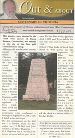
Newspaper - Newspaper articles by Ken Arnold, Out &About, 2000 - 2003
... The Welcome Stranger. Moliagul 8.3.02 86. Campbell’s Creek Reserve 15.3.02 87. ...The Welcome Stranger. Moliagul 8.3.02 86. Campbell’s Creek Reserve 15.3.02 87. ...Ken Arnold is a Bendigo author and publisher.A series of one hundred and thirty-five articles written by Ken Arnold and published in the Bendigo Weekly between 2000 and 2003. Each article has a topic or theme and includes historical information and details. Each article includes a photograph. The articles are stored in a red vinyl covered two ring A5 folder. Index below. Number Article Name Date 1. Centenary of Victoria 19.5.00 2. Storm Water Drain 26.5.00 3. Granite Rollers 2.6.00 4. Poverty Mine 9.6.00 5. Golden Monument. St Arnaud 16.6.00 6. Turner Statue 7.7.00 7. Gold Monument. High St Golden Square 30.6.00 8. Gold Monument. Howard Square Bendigo 14.7.00 9. Lansell Statue 21.7.00 10. Shelbourne West School 18.8.00 11. Mologa’s State Schools 25.8.00 12. Salinity Stone. Pyramid Hill 1.9.00 13. Cairn. Carisbrook 8.9.00 14. Commemorative Markers. Taradale 15.9.00 15. Burke Monument. Castlemaine 22.9.00 16. Cairn. Harcourt area 29.9.00 17. Cairn Marks Gold Route 6.10.00 18. Volcanic Rock Cairn. Woodstock 13.10.00 19. Garfield Water Wheel 20.10.00 20. Anticline. Castlemaine 27.10.00 21. Lawson Bridge 10.11.00 22. Plaque. Sutton Grange area 17.11.00 23. Memorial Cairn. Maryborough 1.12.00 24. Lonely Grave 8.12.00 25. Moonlight Flat Church 5.1.01 26. Historic Church. Near Tullaroop reservoir 12.1.01 27. Granite Statue. Castlemaine 19.1.01 28. Marker. Near Tullaroop reservoir 25.1.01 29. Church Site. Mologa 2.2.01 30. Church Site. Mologa 9.2.01 31. Plaque. Mologa 16.2.01 32. Mincha School 23.2.01 33. Historic Marker. Mincha 2.3.01 34. Expedition Marker. Pyramid Hill 9.3.01 35. Irrigation Marker. Tragowel 16.3.01 36. Mologa School Sites 23.3.01 37. Cairn. Pyramid Hill 30.3.01 38. Plaque. Pyramid Hill 6.4.01 39. Bristol Hill Lookout Tower. Maryborough 12.4.01 40. Eppalock Reservoir 20.4.01 41. Colbinabbin Cairn 27.4.01 42. Mount Macedon Cross 4.5.01 43. Memorial Gateway. Macedon 11.5.01 44. Cairn. Daylesford 18.5.01 45. Grave. Carlsruhe 25.5.01 46. Water Tower. Elmore 1.6.01 47. State School Site. Glenalbyn 8.6.01 48. Cairn. Kanya 15.6.01 49. Lonely Grave. Wedderburn 22.6.01 50. Church Cairn. Glenalbyn 29.6.01 51. Kamarooka School 6.7.01 52. Granite Marker. Moyston 13.7.01 53. Memorial Park. Kerang 20.7.01 54. Water Plaque. Bears Lagoon 27.7.01 55. Cemetery. Bears Lagoon 3.8.01 56. Race Monument 10.8.01 57. Cairn. Pyalong 17.8.01 58. Cairn. In memory of Edward Parker 24.8.01 59. Mt Macedon 31.8.01 60. Mt Macedon Cairn 7.9.01 61. Expedition Pass. Chewton 14.9.01 62. Granite Archway. St Arnaud 21.9.01 63. Stuart Mill School Site 28.9.01 64. School Site. Beazley’s Bridge 5.10.01 65. Fosterville 12.10.01 66. Barnadown 19.10.01 67. Salisbury School Site 26.10.01 68. Cricket History at Wattle Flat 2.11.01 69. School Site. Waterloo Plains 9.11.01 70. Carapooee School Site 11.01 71. Turkish Gun. Maldon 11.01 72. Kooreh 30.11.01 73. Marnoo East School 7.12.01 74. Bulgana Site 14.12.01 75. Emu School 21.12.01 76. Kooroocheang 4.1.02 77. Church Site. Gre Gre North 11.1.02 78. Carmens Tunnel. Maldon 18.1.02 79. Monument. Maldon 25.1.02 80. Woodfull Plaques. Maldon 1.2.02 81. Carapooee. St Peters Anglican Church 8.2.02 82. Cairn. Kingower 15.2.02 83. Cob & Co Stopover. Rheola 22.2.02 84. Flynn Monument 1.3.02 85. The Welcome Stranger. Moliagul 8.3.02 86. Campbell’s Creek Reserve 15.3.02 87. Mine. Fryerstown 22.3.02 88. Escott Grave. Near Chewton 28.3.02 89. School No 808. Kurting area 5.4.02 90. Graves. Bendigo Creek 10.5.02 91. School. Fish Point, Benjeroop North 17.5.02 92. Old Township. Diggora 24.5.02 93. Diggora West (1) 31.5.02 94. Diggora West (2) 7.6.02 95. School No 2735. Gower East 14.6.02 96. Pannoomilloo 21.6.02 97. Kamarooka Settlement 28.6.02 98. Mincha West State School No 1931 5.7.02 99. Bridges. Arnold 12.7.02 100. Woodvale 19.7.02 101. A Famous Son of Raywood. Jack Donaldson 26.7.02 102. Tandarra Area Schools 2.8.02 103. Dingee 9.8.02 104. Avonmore 30.8.02 105. Myola East School 6.9.02 106. Colbinabbin West 13.9.02 107. Colbinabbin West School 20.9.02 108. Runnymede area 27.9.02 109. Wanalta 4.10.02 110. School Sites. Between Wanalta and Carop 11.10.02 111. Burramboot 18.10.02 112. Kangaroo Chair. 25.10.02 113. Mincha South 1.11.02 114. Woodlands Church 8.11.02 115. School site. Sylvaterre 15.11.02 116. Terrick Terrick 22.11.02 117. Leitchville 29.11.02 118. Pennyweight Cemetery. Castlemaine 6.12.02 119. Mincha Area 13.12.02 120. Musk School 20.12.02 121. Dowie Park. Carisbrook 3.1.03 122. Neereman School Site 10.1.03 123. Bald Rock 17.1.03 124. Sylvaterre School Site 24.1.02 125. Carlsruhe 31.1.02 126. Athenaeum. Maldon 7.2.03 127. School. Mincha West 14.2.03 128. Yarraberb 21.2.03 129. Settlement Marker. Ravenswood Estate 28.2.03 130. Comini Reserve. Ravenswood 7.3.03 131. Ironbark and Gold Track. Whroo 14.3.03 132. Burke and Wills Obelisk. Castlemaine 21.3.03 133. James Cook Statue. Myers St Bendigo 28.3.03 134. St Marys Church. Axedale 4 .4.03 135. Butter Factory Site. Warragamba 11.4.03 events, monuments, historical sites, landmarks -
 Ballarat Heritage Services
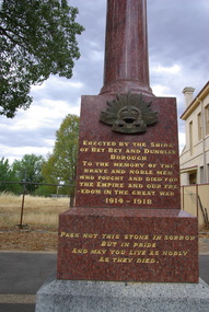
Photograph - War Memorial, Lisa Gervasoni, Dunolly War Memorial, 2025, 1921
... I gave all the Dunolly boys your best wishes and they all wish to be remembered to you— also the same remembrance from Dave Millar, who used to play football for Dunolly from Moliagul. He is in our battalion, having come over with reinforcements. ...I gave all the Dunolly boys your best wishes and they all wish to be remembered to you— also the same remembrance from Dave Millar, who used to play football for Dunolly from Moliagul. He is in our battalion, having come over with reinforcements. ...The Dunolly World War One Memorial Pillar, located in front of the Town Hall on Broadway Street, and was unveiled on November 18th 1921. The pillar is topped by an urn and rests on a square concrete plinth, which lists the names ninety-four locals who died serving during the First World War. On Friday afternoon the Premier, accompanied by Messrs. Pennington and Groves, M's.L.A., visited Dunolly, and unveiled a soldiers' memorial — a polished granite column on a square base, erected by the residents at a cost of £300. It bears the names of 94 district soldiers who were killed in action. The Premier, who is a native of Dunolly, referred to his early associations with the town and district. Speaking of the valiant service rendered by the Australian soldiers in the great war, he paid a tribute to those who enlisted from the country districts. He was not one of those who would withhold national memorials to the fallen because provision had not been made for all who had returned. It was right and proper to have these memorials as silent reminders of the great sacrifice made by the many as a lasting tribute to their memory. Messrs. Groves and Pennington and local clergymen also spoke. The school children sang O God, Our Help in Ages Past, and a bugler sounded the Last Post after the unveiling. The shire president entertained the visitors and committee at dinner. The Age (Melbourne), 19 November 1921. Colour photograph of the Dunolly War Memorial. Front Inscription "Erected by the Shire of Bet Bet and Dunolly Borough To the memory of the brave and noble men who fought and died for the Empire and our freedom in the Great War 1914 - 1918. Pass not this stone in sorrow but in pride, and may you live as nobly as they died." "Private L. Polinelli has written several letters to his mother at Dunolly, dated from from Tel el Kebir from January 13th till the 22nd. He had written every day or two, and this example, is a very fine one. He explains why there was an interval some weeks during which he sent no letters. This was just before the evacuation of Gallipoli, and no-one was permitted to send letters at such a critical time, as there were fears that carefully arranged plans might leak out in some way. Gallipoli had been evacuated on the 19th December, which happened to be Private Polinelli's 24th birthday, and he has cause, he says, to remember that birthday particularly, when this important movement, in which he participated, was so success-fully carried out. He was in the best of health. They had been on Lemnos Island for two weeks after leaving Galilipoli, and while there they got billeted and numerous gifts from Australia, which gave great delight. He (Private Polinelli) had got a big mail - 35 letters and a number of parcels. Both Norman Watson and himself were feeling well, although they had a pretty rough time at the front, but they were feeling better every day. Further letters speak of the arrival in Egypt and the Australian being encamped at Tel el Kebir, 40 miles from Cairo. He states that W. Lyndon had returned from England and was with them. He (W. Lyndon) looks splendid and had had a splendid time in England and Scotland. He saw Jack Lewis in England, and thinks he was to return to Australia. Reference is made to the Rev. Father Goidanich who was with their brigade, and who had been wounded at the front, but was all right again. Father Goidanich is well-known in this district. The letters were written in good spirits and many references were made to friends in Dunolly and district. A friend in Dunolly has received a letter from Private L. Polinelli, which is dated February 3rd, and written 'from the Arabian Desert.' This covers a vast extent of country, so that there is no use in speculating as to the locality, and portions of the letter which possibly would have given some indication have bean 'censored.' Private Polinelli wrote that Norman Watson and Himself were in the best of health and have stook the life well. They are right out of civilisation at time of writing. He referred to their Dtsojourns at Lemoos Island, where Christmas was spent, and where the billies and puddings assisted much in their enjoyment. But they were glad to leave Lemnos Island. After being in camp at Tel el E-bir for two weeks they were sent to where they were at the time of writing, all being in good xxxx and the open country suiting them well. He speaks with admiration of the desert work done by the camels so very largely used. The censoring was very strict so that he could not give much news. After alluding to the return to splendid health of W. Lyndon from England, he says he saw a lot of others from round Dunolly on returning to Egypt, including Tom Fishlock, R. Johnson, and J. Taylor, and some others from Betley, and all looked well. He had also seen Erie Williamson a few times, and he looked splendid. He concludes with remembrances to friends, and from himself and Norman Watson to the Loyal Prince Alfred Lodge." (Dunolly and Betbetshire Express and County of Gladstone Advertiser, Tue 14 Mar 1916) "SOLDIER'S LETTERS PRIVATE L. POLINELLI A friend in Dunolly has received another interesting letter from Private L Polinelli, son of Mrs J Davis, South Dunolly. It is from "Somewhere in France," and is dated July 23rd. He remarks with regret that a good deal of the soldiers' mail from Australia went down in the Arabia, and then goes on to say:- "Norman is back here with us again now and looking well. He had a splendid time over in England after he was able to get out of bed. It was two years on the 18th of this month (January) since Norman and I enlisted, and we celebrated the occasion by having a bit of an evening out. I am very pleased that he is back; we spend most of our time together. We are at present out of the line having a spell in a village, so we are not having a bad time just now but we will soon be going into the trenches again. I met Wally Bell a few days ago; they were going into the line to relieve our brigade. We did not have time to have a long talk. He looks rather thin, but he was always that way. He is feeling well, and wishes to be remembered to his friends in Dunolly. I also met C. Game the same day; he looked well but, as he was also going into the line, we could not have much of a talk J. Hughes and C. Atherton are also over here now; I often see them. W. Lyndon and T. Miles are well ; I was speaking to them yesterday. We are having very bad weather over here now ; it is either raining or snowing every day. The snow was about a fool deep a few days ago. When the rain comes after it, it makes things muddy, The mud is very bad over here; it takes us all our time to struggle through it in places. We will all be very glad when the winter is over. I was over in England on furlough last month, and had a splendid time. The people over there do all they can to give us a good time. I had several invitations to visit different people, and those that we did visit gave us a splendid time. At the place where I was staying they always had a guide waiting of a morning to show us any place of interest that we wanted to see. There was also always a supply of free tickets to the different theatres if we wanted them ; so you see that they go to some expense to give ns a good time. When they know yon are from France you are sure of a hearty welcome. was up in Scotland, and spent five days in Edinburgh. It is a very pretty place, especially when it is seen from Edinburgh Castle, which is on a high bill overlooking the place. We veil through the Castle; also Holyrood Palace. There are a lot of interesting things to be seen in the two places connected with the history of Scotland. It was snowing very heavily while v« were in Scotland, and we bad some fine snowballing with the Scotch people. I greatly enjoyed the trip to Scotland. It would take a very long time to see all round London. I saw a lot of the old historical places there, which were very interesting. The fogs are very bad in London. I had an experience of a London fog one day; it was the heaviest they experienced for a number of years. We could only see a few yards ahead of us. Nearly everyone carried torches; it looked very funny. . . . There are nearly always as many women drinking in the bars as men; it struck me as being very strange, a bit different to what we are used to in Australia, a trip through some parts of London is a real eye-opener to us. It is interesting to watch the traffic in some of the business parts of London it moves along in one big mass. It is a wonder that a lot more accidents do not happen. I saw Australia House, where the High Commissioner has his office, in the Strand. It is not yet finished. It looks a very fine place, and when completed will be 'some' place. Both Norman and I are well, and send remembrances to friends." (Since this letter was written we have had the sad news of the death from wounds of Privates Atherton and Hughes, and that Sergeant Miles and Corporal Norman Watson have been wounded.) (Dunolly and Betbetshire Express and County of Gladstone Advertiser , Friday 13 April 1917, page 2) "Private L Polinelli, from some of whose previous letters we have published interesting extracts, has written to a friend in Dunolly, the letter being from France, and dated April 28th. Private Polinelli says among other things, "I am pleased to say that, Norman (Watson), Les (Anderson) and myself are in the best of health. We now have been in France some time. It is a terrible place for rain ; It has been raining all the time we have been here. It has also been very cold, snowing at times, but it is starting to "fine up" now, and the last few days have been splendid. I hope it keeps like that for a while, as it makes things very miserable in the trenches when it is so wet. We get a few days spell out of the trenches every now and again; so things are not as bad here as they were at Gallipoli. It is not so lively here so far as it was over there either. I am sorry to say that Jack Sanderson, who had been Will Lyndon's mate since they joined the forces, got killed during a bombardment last night. He was terribly knocked about with a shell. I saw W. Lyndon to-day and he was telling me all about it. He seemed terribly cut up over it, and so am I, as I was with Jack a lot over at Gallipoli after Will got sent away sick. He was always bright and cheerful, always had a smile up whenever I met him. I feel very sad about it. We will do all we can to make the Germans pay for it. You will most likely know him, as be used to live in Dunolly before going to Bendigo. Will Lyndon had a narrow escape also, as he was not very far from where the shell burst. He escaped with a bit of a shock, otherwise he is in the best of health. We have a good time among the French people when we are out of the trenches. They do all they can to make us feel at home. I am getting quite expert at speaking French. They smile at us a treat trying to speak French, but we generally make ourselves understood and have a good time among them. It is very rarely we see a young Frenchman, they being all away fighting. The women do all the work on the farms themselves, and deserve every credit for it. . . . I was sorry to hear about the death of Nurse M'Mahon; she was a grand old nurse. I heard that her daughter Nelly was nurse in a hospital on Lemnos Island, and when we were there I went to two of the hospitals to try to see her, but she did not happen to be at either, and I had no time to visit any of the others, so I did not see her. I was also sorry to hear about Mrs Rokahr, as she has left so many little ones behind. (Reference is made to other happenings in Dunolly.) So far I am pleased to say Norman and I have had the luck not to have had a day's illness; I think we are very fortunate, as such a lot get sent to the hospital ill. We are also lucky to have escaped the bullets and shells so far. I hope that luck sticks to us. I am sorry that, owing to the censorship, I cannot give you any interesting news of our trip over to France and the places we have seen. I will have to keep that till I get back to Dunolly again. . . . I have just heard that the battalion that Teddy Game is in has arrived, so I am going to look him up first chance I get." (The letter concludes with remembrances to members of the Lodge and other friends.) (Dunolly and Betbetshire Express and County of Gladstone Advertiser, Tuesday 13 June 1916, page 3) "PRIVATE L POLINELLI Another very interesting letter has been received by a friend in Dunolly from Private L. Polinelli, from France dated May 4th, 1916- Private Polinelli says-" I was glad that you got the letter I wrote from the Arabian Desert. The Censor must have crossed a good deal of it out. They seem to cross out a lot more than is really necessary. We left out there all of a sudden, and in a very short while found ourselves over here. It does not take them very long to make a move. I was saying in the last letter that I was going to try and find " Teddy " Game. I met him a few days ago and had a good yarn with him; he looks real well. I also met S. Prew, and "Ted" Smyth and his son Ernie. They all looked splendid, and are in the same battalion. "Ted" Smyth sticks to it well, and looks better than he ever looked. They will be under fire for the first time in a few days. S. Prew was hit in the landing at Gallipoli, but be is quite well now. W. Smythe, who is in our brigade is well ; I see him very often. " Les " Peart is not with us now; he has joined a Pioneer battalion, and I have not seen him since he joined it. I gave all the Dunolly boys your best wishes and they all wish to be remembered to you— also the same remembrance from Dave Millar, who used to play football for Dunolly from Moliagul. He is in our battalion, having come over with reinforcements. I see him every day and he wished to be remembered to you. A brother of Mr A. J. Williamson, manager of the Bank of Victoria, Dunolly, is also in this battalion. He is a great friend of mine ; we often have a talk about Dunolly. He was not well a little while ago, having to go into a hospital, but is all right again and is back with me. Eric Williamson, son of Mr A. J. Williamson is over here ; Norman (Watson) saw him a few days ago and said he looked well. Norman has been a corporal for some time. I was also offered stripes lately, but preferred to remain a private. There is a lot of worry and running about when you are an N.C.O., so I think I will remain as I am. ... So football is about done this season. I don't think they should cut it right out. I suppose some of them have to stay at home, so they ought to have some amusement. I would very much like to have a game, but I think I would just about forget how to play now. It is very amusing for us to read some of the soldiers letters in the Australian papers. . . l told you in the last letter about xxx young "Jack "Sanderson ; I was terribly sorry about him." Private Polinelli mentions in a letter to his sister in Dunolly that he happened to be beach at Gallipoli where the late Lord Kitchener was xxxxx addressed the' soldiers and' xxxxxx to them the message from the King. Private Polinelli states that he was very proud to have been one of those addressed by the great man. He and Norman Watson have never been a day out of the lines since arriving first in Egypt. It is intended to grant special leave to all those who have been kept so close to their posts xxx three months, and they are looking forward to this relaxation with keen anticipation, hoping to visit England and Scotland. (Dunolly and Betbetshire Express and County of Gladstone Advertiser, Tue 27 Jun 1916) "SOLDIER'S LETTERS. CORPORAL L. POLINELLI. Two letters have been received by Mrs J. Davis, South Dunolly, from her son, Corporal L. Polinelli, both written subsequent to the time when he was wounded, as reported when word was received at the time. Corporal Polinelli writes from No. 12 General Hospital, Rouen, France, and his first letter is dated 7th May. He stated that he was in hospital, he having been wounded in the arm and shoulder on 3rd May. He continued— " It is not a bad wound, and will not take long to heal up, as it is a clean wound. I was very lucky to get out of the fight alive, as I was buried by a shell explosion about an hour before I was wounded. It was very rough, and the noise of all the shells was terrible. Four men were killed by the same shell that wounded me, so I was fortunate. I am feeling a bit " shook up," and my head is aching from the concussion of the shells, but after a few days' spell in bed here I will be feeling just the thing again. So you need not worry about me ; a week or two will see me quite right again. We are having very nice warm weather just now-pleasant change after all the bad weather we have had." The second letter is dated May 12, Corporal Polinelli saying— "I am getting along splendidly ; the wound is healing up fast, so it will not be very long before I am quite right. The doc-tor, the other day said it would be better not to take the piece of shell out of my shoulder yet, and that it would not interfere with me in any way ; so perhaps l will always carry it about with me. He feared lest taking it out at that time would interfere with an artery. Rouen, where the hospital is, is a very pretty city. They give us leave to visit all the places when we are well enough. It is a nice spell here, away from the firing line. We have nothing to trouble us at all, so I will soon be just the thing again. When I got buried by a shell it shook me up a good deal. I felt it far more than the wound I got after; but it has not done me any harm, as I feel hardly any effects now. My good luck sticks to me in getting out of it so lightly. I hope you are not worrying at all about me, as I am all right. We are having beautiful weather over here— sunny days just like the Australian spring. . . . The sisters in the hospital are very nice, and treat us well. They have a lot of work to do, as a good few men have been wounded lately. I would have liked to have been sent over to England, but they are not sending many over there now. They treat as many as they can in France on account of attacks on hospital ships. I would have been able to have a good time with Norman (Watson) had l got over. He was just about all right when I heard from him last." Corporal Polinelli sends kind remembrances to friends." (Dunolly and Betbetshire Express and County of Gladstone Advertiser, Friday 6 July 1917, page 2) "SOLDIERS' LETTERS. CORPORAL L. POLINELLI. The following letter, dated from London on December 27; has been received by a friend in Dunolly from Corporal L. Polinelli (son of Mrs J. Davis, South Donolly), who, at the time of writing, after long and hard service at the front, was on furlough in England. After an introduction he says:— I am having a very good time. I went over to Ireland for five days, spending the most of the time in Dublin. I like the place very much. War appearances are not so conspicuous in Ireland as in England. The hotels are open all day, and a good meal can be obtained anywhere, which is more than can be got in England. The war seems to be making things very bad in England. It is very hard to get a good meal in London ; everything is so restricted. The only way to get a good meal is to go into two places. The people have to line up outside the shops for hours to get sugar, tea, and butter, and then they sometimes fail to get any. So many of our boats getting sunk is the cause of it. If things continue to go on in this way I am afraid that there is a very hard time in store for the people in England. Several people that I have spoken to say that they are just beginning to feel the pinch now. I was in London while an air raid was on a few days ago; it caused a lot of excitement among the people. Ten were killed and 70 wounded in the raid. I was about half a mile from where the bombs fell, so I was pretty right. I thought I had left the war behind in France, but it seems to be on over here at times also. I spent Christmas day with a family at Grantham, a town between London and Newcastle; they were very nice people. I had a very enjoyable time with them. I went to a dance in the evening and enjoyed it very much. It was a bit strange for a start, as it is the first dance I have been to since Norman and I had the send off at Dunolly in January, 1915. They do the dances a bit different over here to what they are done in Australia, and that made it worse still. I went through Guinness's Brewery while I was in Dublin. It is a wonderful place, and covers 55 acres of ground. I got a great surprise when I was starting on my leave in France. We were taken to the station we had to start from in a motor lorry, and who should the driver of the lorry be but Syd. Richards (son of Mr W. Richards, South Dunolly), who used to work at the Post Office in Dunolly. I rode on the front with him, so we had a good yarn. I did not know that be had joined, so was surprised to see him. He has grown a lot since I saw him last, and is looking well. Norman and Bill Lyndon were both well when I left France. We had been having a good spell near Messines, in Flanders, but they will be in the trenches by now. We have been round about Ypres for this last four months, and had some pretty rough times there. dunolly, dunolly war memorial, l. polinelli, bet bet, world war one, world war two, j. deledio, b. battilana, c. fitzgerald, f.s. kendall, j.h. hogan, p. zampatti, louisa davis, louisa gervasoni, bill lyndon, norman lyndon, sydney lindsay -
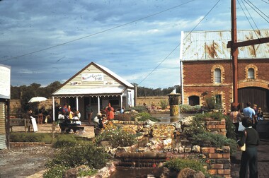 Bendigo Historical Society Inc.
Slide - CHS, BENDIGO POTTERY, EPSOM, BENDIGO, 1978
... History House 11 Mackenzie Street Bendigo goldfields SLIDE Bendigo bendigo pottery CHS Bendigo Pottery Epsom Bendigo Moliagul General Store 1978 Slide. CHS, Bendigo Pottery, Epsom, Bendigo. ...Slide. CHS, Bendigo Pottery, Epsom, Bendigo. Moliagal General Store, weatherboard, pottery stables to the right. Date:4.78slide, bendigo, bendigo pottery, chs, bendigo pottery, epsom, bendigo moliagul general store 1978 -
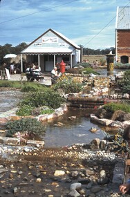 Bendigo Historical Society Inc.
Slide - CHS, BENDIGO POTTERY, EPSOM, BENDIGO, 1978
... History House 11 Mackenzie Street Bendigo goldfields SLIDE Bendigo bendigo pottery - moliagul store CHS Bendigo Pottery Epsom Bendigo Moliagal General Store stables pond Slide. ...Slide. CHS, Bendigo Pottery, Epsom, Bendigo. Weatherboard Moliagal General Store with the edge of the stables to the right, pond in foreground. Date: 4.78slide, bendigo, bendigo pottery - moliagul store, chs, bendigo pottery epsom bendigo moliagal general store stables pond